geology of the montane zone of central … · geology of the montane zone of central colorado with...
TRANSCRIPT
GEOLOGY OF THE MONTANE ZONE OFCENTRAL COLORADO —With Emphasis on Manitou Park USDA Forest Service
Research Paper RM-113October 1973
BySteven R. Marcus
Rocky Mountain Forest andRange Experiment Station
Forest ServiceU.S. Department of Agriculture
rAbstract
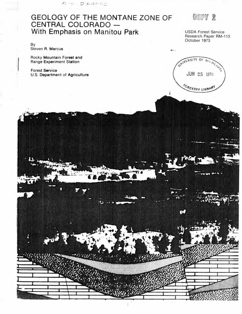
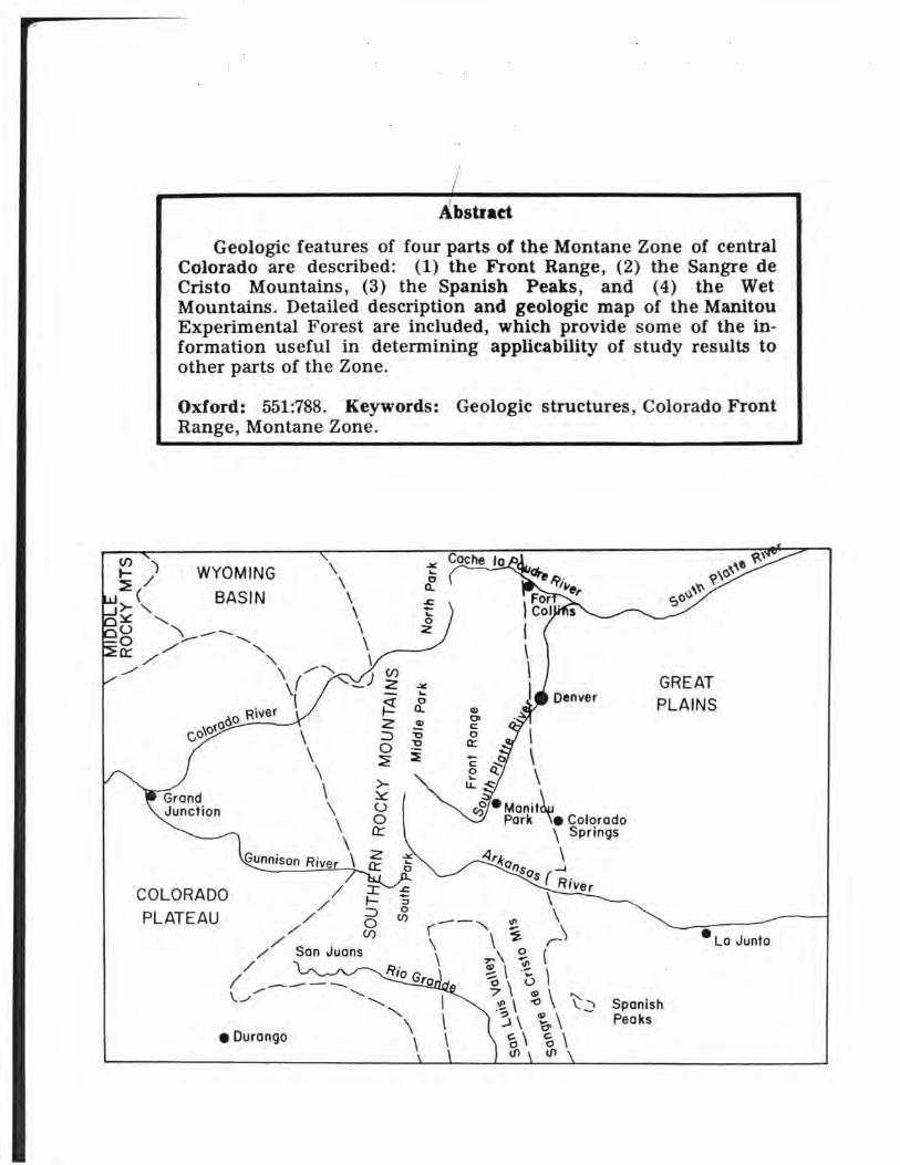
Geologic features of four parts of the Montane Zone of centralColorado are described: (1) the Front Range, (2) the Sangre deCristo Mountains, (3) the Spanish Peaks, and (4) the WetMountains. Detailed description and geologic map of the ManitouExperimental Forest are included, which provide some of the in-formation useful in determining applicability of study results toother parts of the Zone.
Oxford: 551:788. Keywords: Geologic structures, Colorado FrontRange, Montane Zone.
ManitouPark \ Colorado
\s
COLORADOPLATEAU
USDA Forest ServiceResearch Paper RM-113 October 1973
GEOLOGY OF THE MONTANE ZONE OF CENTRAL COLORADO-
With Emphasis on Manitou Park
by
Steven R. Marcus, Associate Geologist
Rocky Mountain Forest and Range Experiment Station1
Central headquarters maintained in cooperation with Colorado State Univer-sity, at Fort Collins.

Contents
Page
Front Range 1Igneous and Metamorphic Petrology 1Boulder Creek Granite 2Silver Plume Granite 2Pikes Peak Granite 2Metamorphic Rocks 3Structure 3Geologic History and Development of the Area 3Physiography 5
Sangre de Cristo Mountains 5Spanish Peaks 7Wet Mountains 7Manitou Park 10
Setting 10Stratigraphy 10Igneous Petrology 16Structure 17Geologic History 17Physiography 18
Setting of Manitou Park in the Front Range 19Literature Cited . ..19

GEOLOGY OF THE MONTANE ZONE OF CENTRAL COLORADO
With Emphasis on Manitou Park
Steven R. Marcus
Use of the Montane Zone of central Coloradofor residential development and recreation isincreasing rapidly. These activities, plus theneed for a high level of management of allnatural resources, place great demands on landmanagers and other decisionmakers. Complexdecisions that involve people and their use ofthe resources must be made with knowledge ofthe effect of one activity on many others. Aseries of studies is underway to provide decision-makers with facts and tools that will help themdo a better job. This publication provides asummary of some of the information that isbasic to these studies.
Most of the Montane Zone of centralColorado occurs on four geologic units: (1) theFront Range, (2) the Sangre de Cristo Mountains,(3) the Spanish Peaks, and (4) the Wet Moun-tains. Each is described in this Paper. Detailedstudies of Montane Zone resources are beingconducted at the Manitou Experimental Forest,west of Colorado Springs. Geologic featureson and near the Experimental Forest, theManitou Park area, are described in detail.Decisionmakers throughout the Montane Zoneof Colorado can compare conditions at ManitouPark with those of their area of interest. Thisprovides one means of determining how wellresults of studies may be extrapolated to theirarea.
Front Range
Igneous and Metamorphic Petrology
The Front Range extends from the Wyomingborder to just south of Denver on the easternslope of the Colorado Rockies, and trends fromdirectly north-south to N. 20° W. It consists ofa wide variety of metamorphic and graniticrocks. Since the granitic rocks intrude themetamorphic layers, the metamorphics are there-fore older.
There are three major granitic plutons inthe Front Range: Pikes Peak Granite in thesouth, and Boulder Creek and Silver PlumeGranites in the northern two-thirds (fig. 1).
According to radiometric data cited by Hedgeet al. (1967), the Boulder Creek Granite is theoldest, Silver Plume Granite intermediate, andPikes Peak Granite is the youngest. There areonly minor differences in composition betweenthe different granitic types (Lovering andGoddard 1950); one difference is that PikesPeak Granite is slightly richer in silica than theothers (table 1).
WyomingColorado
re
Pikes Peak
enver
Sherman
Silver Plume
Boulder Creek
0510 20miles
Figure 1.—Granites of the Front Range.

Table 1.--Chemical composition of the granites of the Front Range (after Lovering and Goddard 1950)
Specimen
1. Boulder Creek granite from the. fifth level of the Cold Springmine close to the new shaft, about 3 miles northeast of Neder-land . -.
2. Local syenitic facies of the Pikes Peakpranite, Ajax miuc, level6. Believed to he related to gneissic aplite.1
3. Gneissic apliie near the breast of ihe Lilly tunnel, Clyde mine,about 2 miles north-northeast of Xederland
4 Pike< Peak granite from Sentinel Point Pikes Peak Colo *5. Pikes Peak granite from Platte Canyon, Jefferson County,
Colo 26. Silver Plume granite, Silver Plume, Colo.3 . _7. Fresh pre-Cambrian Silver Plume cranite from the Climax
district, Colo.48. Loncs Peak granite, Longs Peak, Colorado.3 ,9. Longs peak granite from Sta. 191 South St. Vraiu Highway *_._
10. Mount Olvmpus granite. Glen Comfort3Average of 4 and 5Average of G, 7, S, 9, and 10
Specimen
1. Boulder Creek granite from the fifth level of the Cold Springmine close to the new shaft, about 3 miles northeast of Neder-
2. Local syenitic facies of the Pikes Peak granite, Ajax mine, levelG. Believed to be related to gnei^ic aplite *
3. Gneissic aplite near the breasl of the Lilly tunnel, Clyde mine,
5. Pikes Peak granite from Platte Caiivou, Jefferson County,Colo 2
7. Fresh pre-Cambrian Silver Plume granite from the Climaxdistrict Colo *
SiO:
68.71
66.20
66.3177 03
77 0267.38
70.8371.1470.8571.4077.0270.32
PjOs
0 16
25
0 32Tr
32
15193036
Tr26 1
1
A1:O.
14.9
14.3
• 15.012 0
11 615.2
14.416.015.116.311.817.4.
SOa
0
Fe,03
3 1.02
3 ! 2.09
- 1.350 .76
3 ' 322 1.49
1 .353 .004 .65i .151 .54I .53
1
S (total)
Tr?
0.04
06
01
03
FeO
2.07
1.93
2.71.86
1.092.58
2.94.80
1.571.71.97
1.92
ZrOj
0.02
MpO
1.50
.89
1.03.04
.141.12
.56
.13
.64
.31
.09
. 55
Cl
Tr.
0.04
.01
CaO!
2.01
1.39
2.06.80
1.242.12
64.94.71
1.401.021.16
F
(?)
0.36
.25
Na:0
2.85
2.58
2.483.21
2.852.73
2.445.132.444.593.033.47
FeSi
0.12
K;0
5.14
7.31
5.964.92
5. 215.41
6.213.746.093.245.064.49
MnO
0.13
Tr.
.04
.01
.02
.02Tr..02
H:O-
0.14
.48
0.06.14
.01
.04
.09
.06
.11
.07
.06
BaO
0.18
Tr.
.14
.02
.06
Tr..04
HiO
0.56
.83
0.90.30
.35
.39
1.34.50.77.22.32.64
PrO
Tr.
Ti02
0.02
.65
0.66.13
.70
.24
.17
.31
.36
.06
.36
Li O
Tr.
Tr.
Tr.
CO,
0.46
.36
O.P8
.18
.03
!09
.10
100.17
99.74
99.93100.55
99.8599.82
100.2298.9099.98
100.30
' Oeolojty and gold denosits of the Cripple Creek district, Colo.: U.S. Oeol. Survey * U. S. Geol. Survey Bull. 816-C, p. 225,1933.Prof. Paper 54, p. 45, 190R.
' U. S. Geol. Survey, Geol. Ath«, Castle Fock folio (Xo. 198), p. 3, 1915.' Geol. Soc. America Bull., vol. 45, p. 320. 1934.
NOTE.—Analyses 1, 3. and 7, by J. O. Fairchild; 2 and 4, by W. F. Hillebnmd; 5,by H. N. Stokes; 6, by R. B. Ellestad; 8 and 10, by D. K. Higgins; 9, by T. Kameda.
Boulder Creek Granite
This granite is consistently light gray todark gray, faintly banded to gneissic, andbiotite rich. Strung-out aggregates of blackbiotite and embayed grains of K-feldspar dis-tinguish the outcrops. The fresh rock is mediumto coarse grained, massive, and tough. Itdisintegrates to gray or rusty gravel of biotite-flected quartz and feldspar crystals. Pegmatitesof Boulder Creek genesis contain books ofbiotite.
Silver Plume Granite
This granite occurs in five small batholiths,numerous plutons, and many dikes and sillsin the eastern flank of the Front Range. Thegranites that compose the Log Cabin, LongsPeak-St. Vrain, Kenosha, and Cripple Creekbatholiths and Indian Creek plutons are variants
of the typical granite of the Silver Plume bath-olith and have a common magmatic source.Typical, fresh Silver Plume-type granite ismassive, hard, and tough. It is flesh coloredto tan, fine to medium grained, and produceslittle gravel. Pegmatites genetically related toSilver Plume-type granites are fresh, fleshcolored to gray, and consist mostly of abundantsmoky quartz, flesh-colored potash feldspar,and silver-colored muscovite.
Pikes Peak Granite
The Pikes Peak batholith crops out over80 percent, or about 1,250 square miles, of thesouthern third of the Front Range, while theSherman batholith covers less than 150 squaremiles of the north end. These two granites arenearly identical in mineral content, texture,color, and response to weathering.

Metamorphic Rocks
The unit of biotite gneiss along the south-eastern margin of the central Front Range isconsidered the lowest unit in the area. TheIdaho Springs layer, a lenticular layer of micro-cline-quartz-plagioclase-biotite gneiss, overliesthe biotite gneiss. This unit pinches out indepth and to the south, but appears to thickentoward the east. Another layer that differs fromthe lowest exposed biotite gneiss, mainly incontaining less granite gneiss and pegmatite,overlies the Idaho Springs layer. Above thisunit is the Central City layer of microcline-quartz-plagioclase-biotite gneiss, a unit thatappears to be uniformly thick throughout thenortheastern part of the central Front Rangebut pinches out southwest of Idaho Springs.Above the Central City layer is a thick succes-sion of biotite gneiss, the most widespreadunit at the surface in the area. It includes alenticular layer of quartz diorite gneiss. Theuppermost unit in the region is a thick bodyof microcline-plagioclase-biotite gneiss calledthe Lawson layer. All told, about 13,500 feet ofmetamorphic strata are exposed in the centralFront Range area (Moench et al. 1962).
Structure
The Front Range is a complexly faulted,anticlinal, partly fault-bounded arch. The mainbody of the Range is composed of Precambriancrystalline rocks consisting of highly meta-morphosed metasedimentary rocks that havebeen intruded by granitic masses of at leastthree generations. This Precambrian belt is 30to 40 miles wide throughout the length of theRange. The uplift is bounded by several gentlydeformed structural basins containing sedimen-tary rocks ranging in age from Cambrian toTertiary. The east flank is clearly marked bythe Denver Basin, an asymmetric downwarpwith the axis close to the Front Range. On thesouth the Range ends at the Canon City embay-ment, with the Wet Mountains considered asa separate unit. The west flank is less clearlydefined by two elongated basins, South Parkand North Park, and by a more complex inter-mediate basin, Middle Park. At the Wyomingborder, the Front Range merges into theLaramie and Medicine Bow Ranges (Harms1965).
Elevations of the Precambrian surface withinthe surrounding basins and on the prominentpeaks of the Range indicate a maximum reliefof about 21,000 feet. This maximum occurs nearDenver where, in the Denver Basin, the crystal-
line basement lies at about 7,000 feet below sealevel in contrast to the 14,260-foot summit ofMount Evans. Although the elevation contrastsare less along other segments of the margin,relief on the Precambrian surface of 10,000 feetor more is common (Harms 1965).
The margins of the Front Range are typi-cally marked by major faults and/or steepmonoclines. Most of these faults are reverse anddip toward the center of the Range. In areaswhere no major faults are known, monoclineswith dips commonly more than 30° form themargin of the Range. Prominent hogbacks ofresistant Paleozoic and Mesozoic strata form anarrow foothills belt in the zone of steep dipsnear the mountains, but dips decrease basin-ward to a few degrees within a few miles. Thismeans that a large part of the structural reliefbetween basins and peaks is concentrated withinnarrow belts by large reverse faults and steepmonoclines (Harms 1964).
Geologic History and Developmentof the Area
Following complex deformation and intru-sion during the Precambrian, erosion reducedthe Front Range area to low relief. As noted byCrosby (1895) the Precambrian surface is verysmooth.
In the early Paleozoic, the Front Rangearea was stable. Earliest Paleozoic depositionin Colorado was in Late Cambrian time whenthe Sawatch sandstone was deposited. Othermarine sandstones and carbonates followeddeposition of the Sawatch. They extend overbroad areas and represent a period of stability.No lower Paleozoic sediments are present inthe central and northern Front Range, andPennsylvanian sediments rest directly on thePrecambrian basement rocks. The southernFront Range area, with preserved lowerPaleozoic sediments, has been called the Colo-rado Sag. It behaved differently than adjacentareas which are referred to as the Transconti-nental Arch. Lower Paleozoic beds are exposedin a broken linear belt extending from ParryPark to Canon City, with a second beltextending along the east side of Manitou Park.No basins of deposition developed at this time,and the marine carbonates and sandstone showlittle facies change.
In Pennsylvanian time there was a pro-nounced uplift in the area that was called theAncestral Rockies. This exposed the Precam-brian core, and rapid stream erosion and sub-sequent deposition produced the arkosic andconglomeratic Fountain Formation. Widespread
overlap unconformities were produced alongthe Front Range margins. The area of greatestuplift was slightly more northwest trendingthan the present Front Range, though occupyingmuch the same position. To the north andsouth, Fountain sediments rest on successivelyolder beds until the Fountain is in contact withthe Precambrian at Parry Park and south ofCanon City.
There is a general absence of major deforma-tion in areas adjacent to the uplift. Thisindicates positive movements without broadlateral belts of deformation. In this respect, thePennsylvanian uplift resembles the Laramideuplift, although igneous activity is absent. Thecoarse clastic wedges of the Pennsylvanian andLower Permian require an uplift of only about2,000 to 3,000 feet, and based upon this, the latePaleozoic uplift can be considered a tectonicallymild feature bordered by narrow fault zones ormonoclines. Tectonic stability returned to thearea at the end of the Paleozoic when burial ofthe uplift began.
A mild epeirogenic uplift occurred in Mid-Triassic time, indicated by the truncation ofLower Triassic and Permian beds. Also, Mid-and Upper-Triassic beds are absent in an areacentering upon the Wet Mountains. During theLate Cretaceous, this area became part of amajor marine basin and approximately 10,000feet of shale and siltstone, with some sandstoneand limestone, was deposited. Structurally, theFront Range lost its identity at this time, anddeposition was more or less continuous. Themost significant erogenic movement in the post-Cambrian history of the Front Range, theLaramide orogeny, began at the end of theCretaceous. Marine inundation ended with aregressive sequence of sandstones and coalscalled the Laramie Formation. Structural move-ment began at this time, and arkosic andtuffaceous sands and conglomerates floodedoutward from the Front Range into the DenverBasin and South Park. Angular unconformitieslocally record the severity of the orogeny. Anexample of this severity is the fact that theUpper Cretaceous Laramie sandstone is overlainby Upper Cretaceous and Paleocene Dawsonarkose with an angular discordance of 40° a fewmiles north of Colorado Springs. The nature ofthe Late Cretaceous and Eocene sediments alsoattest to the significance of the Laramideorogeny. These sediments are coarse, conglom-eratic, contain volcanic fragments and tuffs, andare coarsest at the edges of the Front Range,becoming finer grained farther away. Post-Miocene deformation appears limited to regionalwarping, so it is apparent that major orogenic
movement ended in Miocene time. The presentday Front Range owes its height to orogenicuplift, but it was shaped by the erosionalagents of wind, water, and ice.
The various sedimentary beds in the foot-hills and plains are not described here sincethey are not part of the Front Range proper.
The tectonic origin of the Front Range andits structural implications are a subject ofdebate. There are two major theories, onebasedon lateral compression, the other on verticaluplift. Harms (1964) supports the vertical uplifttheory. Some reasons he gives are the milddeformation of adjacent basins, the fact thatuplift is concentrated in relatively narrow beltsalong the margins of the Range, the high reliefbetween mountains and basins of the Precam-brian surface, the symmetry of the Range, andthe large reverse faults and narrow monoclinesalong its margins.
The Laramide and late Paleozoic uplifts areof similar origin though not corresponding inoutline. The zones of weakness that defineLaramide structure rarely occupy positions thatmark Paleozoic or Precambrian deformation.There is little evidence that early structurescontrolled later movements.
The Cenozoic geomorphic history of theFront Range, from Thornbury (1965), is asfollows:
1. Development of the Front Range duringthe Laramide Revolution began with the forma-tion of a broad anticlinal arch contemporan-eously with the downwarping of the DenverBasin. Dikes, sills, and extrusive sheets areevidence for local volcanic activity at this time.
2. Truncation of the Front Range anticlineduring Eocene, Oligocene, and Miocene timeduring a period of intermittent uplift was ac-companied by deposition in the Denver Basinand Great Plains. During one of the periods ofless rapid uplift, the Flattop peneplain wasproduced. This peneplain is represented byridges extending 1,500 to 2,000 feet above theRocky Mountain erosion surface. Rising abovethe Flattop remnants are numerous peaks risingabove 12,000 feet and forming a distinct axisfrom northern Colorado to south of Denver.
3. During a period of relative quiescence inPliocene time, the widespread Rocky Mountainpeneplain formed. This peneplain rises graduallyfrom an elevation of about 8,000 feet at theedge of the Front Range to around 10,000 feetat the crest of the range. The sedimentsremoved from the mountains to produce thiserosion surface were deposited to the east and
may have overlapped onto the eastern edge ofthe Precambrian core.
4. Widespread regional uplift initiatederosion which removed most of the Tertiarysediments from the Colorado Piedmont areaeast of the Front Range and some of the Meso-zoic sediments. This uplift also caused canyoncutting in the crystalline rock belt.
5. Alternating periods of valley cutting andpedimentation in the foothills during Pleistocenetime formed a number of gravel-capped pedi-ments and terraces. These erosional surfacescan be traced a short distance back intothe mountains.
6. Periods of glaciation occurred in thehigh mountains, modifying valley profiles andproducing glacial outwash that was carried downinto the foothills and deposited as gravel capson the Pleistocene terraces. Alternation ofcutting and deposition in the foothills and onthe plains was in response to the periods ofglaciation in the mountains.
7. Recent erosion began at the end of thePleistocene.
Physiography
Eleven different erosion cycles have beenpostulated in the Cenozoic development of theFront Range (Van Tuyl and Lovering 1934).Theearly cycles were terminated mainly by erogenicuplift, the intermediate cycles by combinedlocal and regional uplift, and the later cyclesby epeirogenic uplift, glacially caused climaticchanges, or both. Evidence for these cyclesincludes the presence of benches or strathsalong streams, accordant summits, and imper-fect peneplain surfaces.
In the eastern portion of the Range manybroad "parks" of comparatively gentle relief,partly or entirely surrounded by more ruggedareas, occur in that portion of the mountainsvarying in elevation from about 6,500 to 10,000feet. In the case of Manitou Park, the less re-sistant areas represent outliers of sedimentaryrocks which were either folded or faulted downinto the crystalline rocks. The other parks,however, such as Estes Park, appear to haveformed upon crystalline rocks. They might repre-sent the western limits of broad valleys formedduring earlier erosion cycles. Modification byrock decay, stream erosion, sheet erosion, andpedimentation also may have had some effectin the formation of these parks. There seems tobe little relationship between the character ofthe underlying bedrock and the developmentand preservation of erosion surfaces in the area.
Sangre de Cristo Mountains
The Sangre de Cristo Range extends fromnorth-central New Mexico to south-centralColorado as a long, narrow, rugged range; inColorado it is bounded on the east bythe Arkansas River Valley, Wet Mountain Valley,and Huerfano Park, while on the west it isbounded by the broad, flat San Luis Valley. Tothe north, the Range terminates at the ArkansasRiver near Salida.
Although the Sangre de Cristo Mountainsare the frontal range at the southern end of theRocky Mountains, they are classified with thewestern granite belt rather than the FrontRange.
Geologically, the Sangre de Cristos consistof a core of Precambrian schists, gneisses, peg-matites, granites, and diorite, along with whatis one of the most complexly folded belts ofsedimentary rocks in the southern Rockies onits eastern side. The sedimentary rocks rangefrom Ordovician to Cretaceous (Thornbury1965). The belt of deformed sediments com-prises most of the Range in the north, but inthe south the sediments are confined mainly tothe foothills belt. The Precambrian rocks, whichmake up the western part of the Range southof Blanca Peak, are partially covered withTertiary lavas.
Structurally, the northern Sangre de CristoRange is a fault block uplifted along a con-cealed, high-angle fault that separates the Rangefrom the San Luis Valley to the west. The sedi-mentary layers strike north-northwest, nearlyparallel to the trend of the Range, and dip east30° or more, forming the east flank of theLaramide Sawatch arch. Numerous high-anglestrike faults are present. Faulting is more prom-inent than folding. Structures other than Pre-cambrian are Laramide or younger in age. Thewest slope of the Range is much steeper thanthe east slope, and forms a linear eroded scarpthroughout its length bounding the San LuisValley.
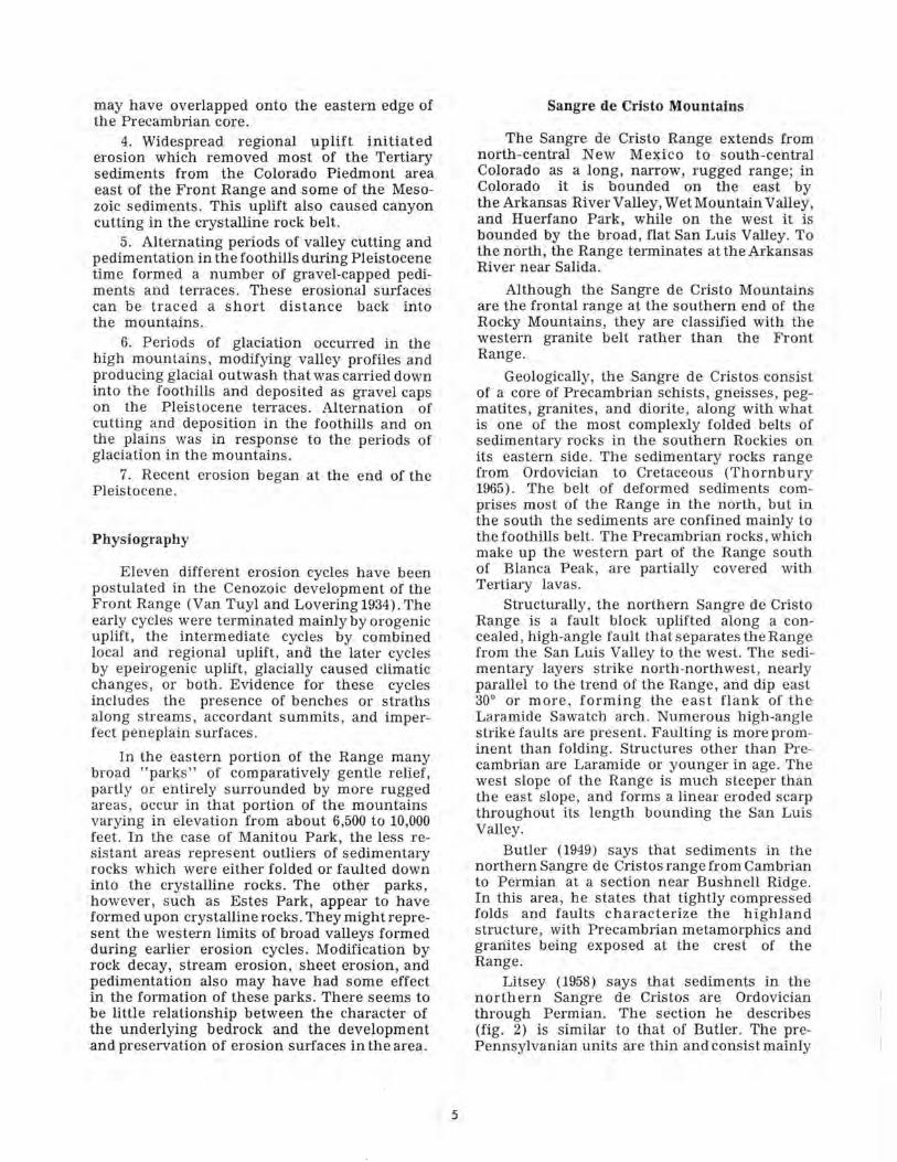
Butler (1949) says that sediments in thenorthern Sangre de Cristos range from Cambrianto Permian at a section near Bushnell Ridge.In this area, he states that tightly compressedfolds and faults characterize the highlandstructure, with Precambrian metamorphics andgranites being exposed at the crest of theRange.
Litsey (1958) says that sediments in thenorthern Sangre de Cristos are Ordovicianthrough Permian. The section he describes(fig. 2) is similar to that of Butler. The pre-Pennsylvanian units are thin and consist mainly
IAGE
CENOZOIC
PE
NN
. A
ND
PE
RM
IAN
PE
NN
SY
LV
AN
IAN
A
ND
PE
RM
IAN
(?
)
PENN.
z
a.a.CO
vtVI
z
1UJo
OR
DO
VIC
IAN
PRE-CAMBRIAN
FORMATION
SANGRE DE CRISTO
FORMATION
MINT URN
FORMATION
KERBER FORMATION
LEADVILLE
LIMESTONE
Dyer
CHAFFEE dolomitemem.
Portingquart? He mem.
FREMONT
FORMATION
HARDING
SANDSTONE
MANITOU
FORMATION
CRYSTALLINE
ROCKS
THICKNESS
V£\
:-.*/ ..*'. •/
•".-. .* :>.'•-
|festli^J
i * i1- !
1 1
1 1>l 1
111 1
1 1
/"•""V* -/*/-/ . /
~7 — ~X~
gg
ooin10
o0oCO
0-150'
^ '%ro1
\O
Vto
^^fW-SH'
/ /
4 /
/ /
/ *// /
/ /
/ * /
/ /
* / /y __/
m
IOto
(0en
10
zfEfLE^T j;
/•/ '
*'t 'f\
V
I
CO
;
i
DESCRIPTION
Glacial grovel and alluvium
Arkosic conglomerate interbedded with redmicaceous sandstone ond thin limestones.
Orob sandstones and fine conglomeratesinterbedded. All are massive. Thinlimestone at top.
Sandstone ond coaly shale.
Limestone, massive, medium gray.Contains black chert nodules.
Dolomite, fine- groined., a lmost l i thographic,w e a t h e r s g ray i sh yel low.
Quar tz i te ond sandy shale.
Dolomite, thick~ bedded or massive,medium gray, somewhat f oss t l i f e rous .
Ouortzite, thick- to thin- bedded, sof tshaly 2one at base. Fish p la tes at lop.
Dolomite, crystal l ine, w e a t h e r s mediumlight g ray or yel lowish gray. Layersof chert common.
Hornblende gneiss and qua r t z biotite gneissintrude d by grani te.
Figure 2.—Paleozoic section in northern Sangre de Cristo Mountains (after Litsey 1958).
of limestone and dolomite with some quartzite,sandstone, and shale. The lithology indicatesstable shelf deposition. Pennsylvanian andPermian rocks were deposited as a thick seriesof clastic sediments in a geosyncline. TheOrdovician Manitou Formation is found here.It is the only formation in the area that isdistinctly correlated with one of the formationsat Manitou Park. Here it rests on crystallinePrecambrian rocks consisting of hornblende
gneiss and quartz biotite gneiss intruded bygranite, whereas at Manitou Park it rests onSawatch quartzite. The Manitou Formation hereis 121 to 197 feet thick, and consists of thin-bedded, siliceous dolomite. In some places theFormation is predominantly limestone or dolo-mitic limestone. Locally, there are sands orshales at the base. It is mostly fine to mediumgrained and generally medium bedded (2 inchesto 2 feet). Fresh surfaces are medium gray;
weathered surfaces light to yellowish gray. ThePennsylvanian-Permian Sangre de Cristo Forma-tion is basically an arkosic conglomerate andmight be partially equivalent to the FountainFormation.
The Precambrian crystalline rocks of theregion represent an ancient complex of gneissicmetasediments invaded by granite of at leasttwo types and ages. West of the Pleasant ValleyFault the Precambrian rocks are metasedimen-tary, ranging from basic hornblende gneissesto acidic schists and quartzites. East of thePleasant Valley Fault the Precambrian is com-posed almost entirely of Pikes Peak Granite withsmall inclusions of metasediments and SilverPlume Granite.
The Tertiary tectonic history of the northernSangre de Cristo Range includes at least threedistinct phases of deformation. The presentrange is the eastern flank of two earlier, largeruplifts.
The first phase of deformation began in LateCretaceous as a broad domal uplift, whichbecame elevated enough by Paleocene time tocause gravity sliding of Permian and Pennsyl-vanian sediments along bedding plant thrusts.Displacement is 10 to 15 miles on the north-eastern and eastern flanks of the uplift. Blockuplift of the San Luis Valley area caused asecond stage of thrusting along boundary faultswhich extended eastward into the site of thepresent Range. This stage of thrusting foldedthe earlier thrusts and caused some deformationin the eastern foothills. A block which rose inthe northeast interfered with thrusting andprobably caused the high-angle faults found inthe northern end of the Range. Collapse of theSan Luis Valley uplift along steep portions ofthe second-stage thrusts began in Miocene andcontinues at present, as shown by Recent faultscarps in alluvium, along the western marginof the Range.
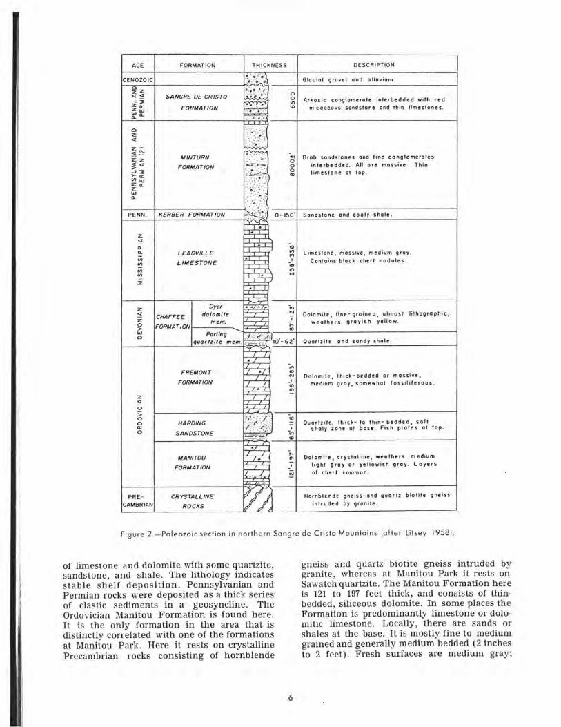
Spanish Peaks
The Spanish Peaks, located just east of theSangre de Cristo Range, are famous for theirunusual system of radial dikes. These dikesextend out from the peaks a distance of 25miles or more (fig. 3). The peaks are borderedon the east by a sloping platform that extendsup to an altitude of nearly 10,000 feet. Toweringabove this platform is the main bulk of themountain. On the platform is a coarse, boulderyfanglomerate, consisting mainly of whiteporphyry. This platform has been dissected toa depth of 500 feet by valleys which extend tothe foot of the mountain, but a short distancefrom the mountain they open out into broad,
shallow, parklike valleys. Conclusive evidenceof glaciation was found at only one locality onthe Spanish Peaks, the north flank of WestPeak. Sediments in the area range from UpperCretaceous to Eocene.
The igneous geology of the Spanish Peaksconsists of two stocks that cut through the LateCretaceous and early Eocene strata, surroundedby an immense number of dikes and sills. Thestocks have broken through an asymmetricsyncline whose east limb is nearly horizontaland whose west limb is vertical or even hasbeen overturned to the east so that locally itdips westward. Each stock is surrounded by asystem of radial dikes.
The East Peak stock consists of: (1) whitegranite porphyry containing phenocrysts ofquartz and feldspar, together with a little horn-blende and biotite, in a phaneritic groundmass,and (2) granodiorite porphyry, containing acces-sory augite and biotite, which is intrusive intothe granite porphyry and, therefore, younger.At the summit, the granodiorite is plutonic.Oligoclase is abundant, with lesser amounts ofanorthoclase, augite, and biotite.
The West Peak stock, although much smallerthan that of East Peak, consists of plutonicrock of several facies of syenodiorite. Thesummit is a pyroxene syenodiorite. The rock,comprising the bulk of the West Peak stock,contains oligoclase, augite, hypersthene, redbiotite, anorthoclase, and minor amounts ofinterstitial quartz.
Between the two peaks is a blackishcordieritic hornfels, formed by the meta-morphism of an arenaceous shale. The igneousintrusions occurred during one of the laterphases of the Laramide Revolution (earlyTertiary).
The area is heavily timbered, mostly secondgrowth. The lower slopes support a densegrowth of pinyon and juniper, while the higherslopes support pine forests with spruce, fir, oraspen as the elevation rises.
Wet Mountains
The Wet Mountains, located just south ofthe Front Range and the Canon City embay-ment, extend northwest-southeast about 50miles and are about 20 miles in width. Theyform the central unit of an en echelon patternwith the Sangre de Cristo Range to the westand the Front Range to the north. There is aclose genetic relationship with the Front Range.
The core of the southern Wet Mountainsconsists partially of Precambrian metasedimen-tary gneiss and schist concordantly foliated withgranite gneiss. These rocks developed by meta-

r
Figure 3.—Structural map of the Spanish Peaks area (after Knopf 1936).
morphic alternation during intrusion of thegranitic San Isabel batholith and accessorysmaller plutons. These plutons are probablyoffshoots of the San Isabel batholith, which isdated at about 1.5 billion years.
Structurally, the southern Wet Mountainsform a southeast-plunging anticline. They were
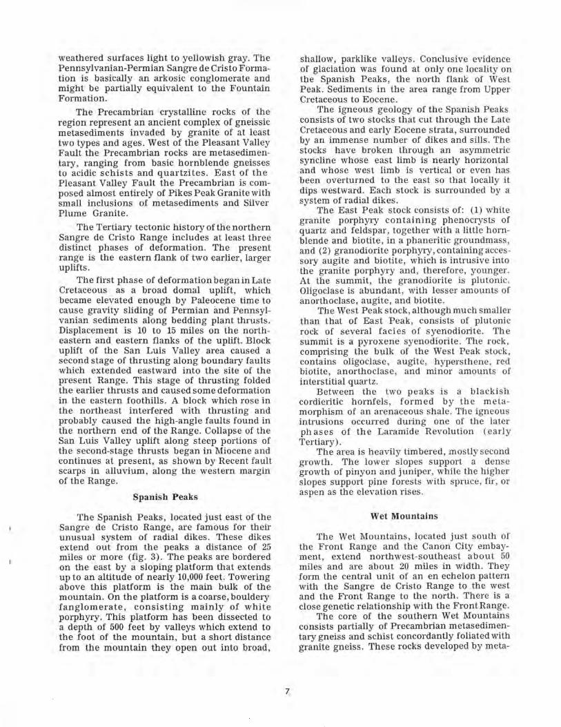
uplifted to their present elevation from middleTertiary through Pleistocene. Uplift occurredin stages along major high-angle boundaryfaults and by slight displacement along themany joints in the area. The age of the sedi-ments ranges from Permo-Pennsylvanian toRecent (fig. 4).
AGE
QUATER-NARY
TERT
IARY
n
^
JURASSIC
PENNSYL-VAN'IAN-
PERMIAN
PR£CAMBRIal>
U7iQnp<
PLIOCENEunr.nnf
MIOCENE
EOCENE
PALEOCEHE
UPPER
LCWER
UPPER
unnanf
fCHMCIOH
ALLUVIUM
TERend
COoral
onal
RACE GRAVELty
NGLOMERATEty
VOLCANICROCKS
ty
FARISITAFORMATION
HUERPANOFORMATION
CUCHARAFOHMATION
PO
oralPI
NIO
BRA
RA
M
»
ISDN CANYONFORMATION
FftRE SHALE
SMOKY HILLKARL
FORT HAYSLIMESTONE
CARLILESHALE
GREENHORNLIMESTONE
GRANEROSSHALE
DAKOTASANDSTONE
PURGATOIREFORMATION
MORRISONFORMATION
orrai
SAN
oralc
ENTRADASANDSTONEtyGRE DE CRISTO
FORMATION
ty
RYSTALLINEROCK
LITHOLOGY
'T^TTTf
>•.'.»•>'?„' -•".-'-<— i-x -i-Ls.« » . » . ' r ' *.,...<? . • .* •.~- ..*.••• •<i>V- iir^— ocsv^^^S~^~*~\?^l°."°-~.~-
'"•' "i" '-"•* '."•'..'
f-i '•Q:"TV*' "i--^Si£»y» . "-. * . j, * . -7". 7.".-.,-.-.:
^.r^:-1;^^* ' ' . "• "
• ' • ' o .". o : ° • ' ..
~—~~ ~ I.
_Xlil^lZJE-r*-, ' i *T 1 , f '
-_i_ --!_ -__r-^J^
.~! r -'~n ~~-+? -^^.-r"=.— -1~~--
"- /L~I-J
" " *-• " ' •
• . "• . -•- •, o -
. ^-- a- ;• •. .-;
• . ""..'• . -". '., o'_T " — **~ •*• i_
^ •£.—3" -":"
:^~:^^:
'•''.•' -°-. ' ' a • ' * •'. » ' . • o •' =
•_ • ' ' O • '
* • '. ' - ' ".*
^3
THICKNESS
IN FEET
Varies
25*
25 *
300 *
1 000 T
2.800
400
1 300
1-800
700
50
200
50
225*
250
50 „
325 «
35 *
7 000-1-
Unknown
DESCRIPTION
Unconsolidated gravel, send,silt and clay along streams
Poorly sorted gravel alongfoothill*
Silica cemented eonglonerat*Tilth Precambrlan fragnents
Porpl\yritlc v«sicular (in ptrt)andesite lava underlain bylacustrine rhyollte tuff
Poorly consolidated heterogeneousyelloK-bronTi ocngl omerate
Unite to buff arkosic sandstoneIntrrbedded «ith reddishbrown to greer. raidstone
Conglomeratic arkose tilthpartings of nudstone
Brotm conglomeratic arkvsaar.d aidstone
Calcareous concretionary grayshale
White to yellow calcareousforaminlferal shale
-Unite lithographic limestonewith shale partings
Dark calcareous (hale ar.d silt-etone with arkecle «andston«at top (Codell n«tb«r}
BluiBh-gray llthogrtphlo line-stone and calctreeuei shale
Dark carbonaceous shale withbentonlte partings
White -to -yellow quartz sand-stone
Gray-white conglomeratic sand-stone
Midstone with feldspathlolltblc sandctone
Massive calcareous quartzsandstone.
Reddish-brewn nudstone abcvegray ar.d brown eonglorieratlearkoslo sandstone, eiltstone,and shale.
Gneisses and schists intrudedby grenltes
Figure 4.—Section of the Wet Mountains area (after Boyer 1962).
The metamorphosed sediments representa sedimentary sequence which is probably inter-layered with volcanic rocks. They have under-gone moderate to high-grade regionalmetamorphism that produced amphibolite,hornblende, biotite gneiss, schist, and granitegneiss. The gneisses and schists are the oldest
and are possibly related to the Idaho SpringsFormation.
Another major part of the Precambrianareaconsists of band, stringers, and lenses of meta-morphic rocks which are closely layered withgranitic material.
The youngest Precambrian rocks are igneousbodies, mostly granitic, which cover half of thearea. The most extensive igneous outcrop isthe San Isabel batholith.
The gneissic granite is medium grained withabundant quartz and microcline, each of theseminerals accounting for more than 30 percentof the rock. Sodium-rich oligoclase constitutes10 to 15 percent of the rock. Mafics contributea low percentage. The rock weathers into sharp,angular-jointed blocks, rather than into roundedor smooth-faced boulders as do the othergranites found in the area. The gneissic graniteis found in the southern end of the Range.
The San Isabel Granite, covering 20 percentof the southern Wet Mountains, consists of twodistinct facies. The more common type is coarseporphyrytic granite cropping out in large bluffsand ridges; less common is a uniformly medium-grained phase. The composition of both typesis similar, with quartz accounting for 25 percentof the rock, microcline about 25 to 30 percent,oligiclase 20 percent, and biotite 15 percent.Prominent accessory minerals are apatite andsphene. The San Isabel Granite extends through-out most of the length of the Wet Mountains.
Manitou Park
Setting
The Manitou Park Basin is a fault outlierabout 30 miles long and 4 miles wide, borderedon the west by the Ute Pass Fault and on theeast by the Devils Head Fault and RampartRange (Boos and Boos 1957). Fowler (1952)called this eastern fault the Mt. Deception Fault.The southern part of the Manitou Park Basincontains an area of relatively soft sedimentsfaulted down below the general summit level.The sedimentary structure is basically a west-ward dipping homocline or monocline. Reliefin the area is approximately 1,600 feet, rangingfrom 9,200 feet in the Rampart Range to theeast to about 7,600 feet in the Trout CreekValley (Sweet 1952). Trout Creek is the onlypermanent stream in the area, though intermit-tent streams flow in most of the larger gulches.Drainage in the area is north-northwest towardthe South Platte River which eventually emptiesinto the Missouri River. In the southern partof the Basin, the Pikes Peak Granite is coveredwith Paleozoic sediments dipping west. Abovethese sediments is a gravelly soil derived mostlyfrom granite. In the northern half of the Basin,Pikes Peak Granite is not covered by anyPaleozoic sediments, though it is covered by adeep layer of Quaternary alluvium.
Stratigraphy
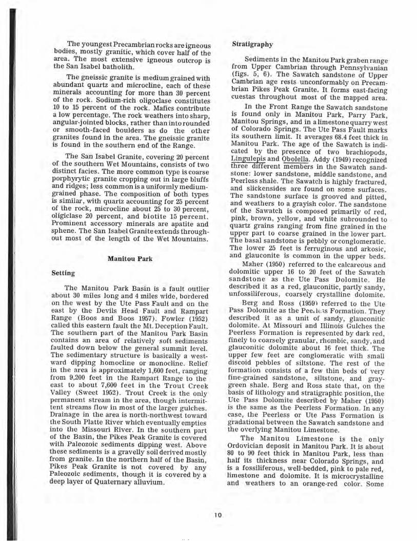
Sediments in the Manitou Park graben rangefrom Upper Cambrian through Pennsylvanian(figs. 5, 6). The Sawatch sandstone of UpperCambrian age rests unconformably on Precam-brian Pikes Peak Granite. It forms east-facingcuestas throughout most of the mapped area.
In the Front Range the Sawatch sandstoneis found only in Manitou Park, Parry Park,Manitou Springs, and in a limestone quarry westof Colorado Springs. The Ute Pass Fault marksits southern limit. It averages 68.4 feet thick inManitou Park. The age of the Sawatch is indi-cated by the presence of two brachiopods,Lingulepis and Obolella. Addy (1949) recognizedthree different members in the Sawatch sand-stone: lower sandstone, middle sandstone, andPeerless shale. The Sawatch is highly fractured,and slickensides are found on some surfaces.The sandstone surface is grooved and pitted,and weathers to a grayish color. The sandstoneof the Sawatch is composed primarily of red,pink, brown, yellow, and white subrounded toquartz grains ranging from fine grained in theupper part to coarse grained in the lower part.The basal sandstone is pebbly or conglomeratic.The lower 25 feet is ferruginous and arkosic,and glauconite is common in the upper beds.
Maher (1950) referred to the calcareous anddolomitic upper 16 to 20 feet of the Sawatchsandstone as the Ute Pass Dolomite. Hedescribed it as a red, glauconitic, partly sandy,unfossiliferous, coarsely crystalline dolomite.
Berg and Ross (1959^ referred to the UtePass Dolomite as the Peeiless Formation. Theydescribed it as a unit of sandy, glauconiticdolomite. At Missouri and Illinois Gulches thePeerless Formation is represented by dark red,finely to coarsely granular, rhombic, sandy, andglauconitic dolomite about 16 feet thick. Theupper few feet are conglomeratic with smalldiscoid pebbles of siltstone. The rest of theformation consists of a few thin beds of veryfine-grained sandstone, siltstone, and gray-green shale. Berg and Ross state that, on thebasis of lithology and stratigraphic position, theUte Pass Dolomite described by Maher (1950)is the same as the Peerless Formation. In anycase, the Peerless or Ute Pass Formation isgradational between the Sawatch sandstone andthe overlying Manitou Limestone.
The Manitou Limestone is the onlyOrdovician deposit in Manitou Park. It is about80 to 90 feet thick in Manitou Park, less thanhalf its thickness near Colorado Springs, andis a fossiliferous, well-bedded, pink to pale red,limestone and dolomite. It is microcrystallineand weathers to an orange-red color. Some
10
fossils described by Fowler (1952) at the fishhatchery exposure are Apheorthis, Nanorthis,Sinuites, a cystoid plate, Hystricurus, Finkeln-
Age
Pennsylvania
Mississippian
Devonian
Ordovician
Cambrian
Precambrian
+ .+
"'/M*s.l
Formation
Fountain
Madison
Williams Canyon
Manitou
Ute Pass member
Sawatch
Pikes Peak Granite
Figure 5.—Stratigraphic section of Manitou Park area.
burgia, a prorocycloceras cephalopod, Kainella,and Leiestegium manitouensis. This suite indi-cates a Lower Ordovician age.
Petrographic evidence indicates that theManitou Formation originated in an environ-ment of low to moderate energy. The particlesshow evidence of rounding and abrasion, butthe energy level of the depositional environmentwas not sufficient to remove much of themicrocrystalline material except during briefperiods of high energy. Some of the mineralsformed in place include dolomite, calcite, chert,limonite, hematite, and glauconite. The dolomitepercentage in the samples studied by Swett(1964) ranged from 45 to 95. The dolomite canbe recognized by its buff color in contrast tothe grayish color of limestone. Chert is alsopresent. Thin-section studies show evidence offive post-depositional alterations of the originallimestone: (1) Grain growth caused by recry-stallization of microcrystalline calcite to sparrycalcite, (2) dolomitization, (3) silicification rang-ing from partial void filling to formation ofchert layers, (4) the addition of calcite to thechert and dolomite layers, and (5) oxidation ofiron-bearing minerals to limonite and hermatite.
The Devonian-Mississippian Williams Can-yon Limestone is of uncertain thickness andseparated by nonconformities from the Missis-sippian Madison Limestone above and theOrdovician Manitou Limestone below. TheWilliams Canyon, named for its type sectionexposed near the Cave of the Winds in WilliamsCanyon, consists of thin, pale, reddish purpleto gray mottled limestone and dolomite, con-taining partings of gray calcareous shale. Theupper 2 to 4 feet is a medium-grained sand-stone (Maher 1950). Maher dates the WilliamsCanyon as Mississippian by lithologic correla-tion with subsurface units of eastern Colorado.Brainerd et al. (1933) considered it Devonian,and correlated it with the Chaffee Formation ofcentral Colorado.
Blocks of the Williams Canyon Limestoneare intermingled with the Madison Limestonedue to folding and faulting. The WilliamsCanyon is more dolomitic than the Madison andalso softer. Soils developed from the WilliamsCanyon are dark gray to nearly black. They arerelatively high in clay and have a good abilityto hold water. Nitrogen and potassium levels areadequate for growing most plants, but phos-phorus is deficient. Lime content is high, andthe pH is about 8.0, similar to that of Madison-derived soils.
The Mississippian-Madison Formation over-lies the Williams Canyon Limestone unconf orm-ably. The upper surface of the Madison isirregular with a well-developed buried karsttopography due to post-Madison and pre-Foun-
11

?»mfcR&s
12

pfa5f~7
•Wr'--x&>;%W%^v ,rv$$m$&
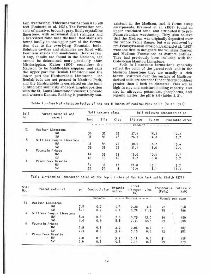
Legend
Quaternary Alluvium
Pennsylvanian Fountain
Lowest terrace
Intermediate terrace
Highest terrace
Paleozoic Limestones(Ord-Miss )
Cambrian Sawatch Sandstone
Precambrian Pikes Peak Granite
-fr ~,i i 'N'\ i - - -J s'^Z ilf immm*^7^t^ferfcS5i//-V-
MANITOU
EXPERIMENTAL FOREST
Figure 6.—Geologic map of Manitou Experimental Forest.Stippled (gray) areas indicate private land within theForest area.
13
tain weathering. Thickness varies from 0 to 200feet (Brainerd et al. 1933). The Formation con-sists of massive, brown to gray, finely crystallinelimestone, with occasional chert stringers anda brecciated zone near the base. Red stains arefound locally in the upper part of the Forma-tion due to the overlying Fountain beds.Solution cavities and sinkholes are filled withFountain shales and sandstones. Because few,if any, fossils are found in the Madison, agecannot be determined more precisely thanMississippian. Maher (1950) considers theMadison to be Middle-Mississippian, and callsthe upper part the Beulah Limestone and thelower part the Hardscrabble Limestone. TheBeulah beds are not present in Manitou Park,and the Hardscrabble is correlated on the basisof lithologic similarity and stratigraphic positionwith the St. Louis Limestone of eastern Coloradoand western Kansas. Bedding is practically non-
existent in the Madison, and it forms steepescarpments. Brainerd et al. (1933) found anupper brecciated zone, and attributed it to pre-Pennsylvanian weathering. They also believethat the Madison was originally deposited overthe whole Front Range, but was removed bypre-Pennsylvanian erosion. Brainerd etal. (1933)were the first to designate the Williams Canyonand Madison Formations as distinct entities.They had previously been included with theOrdovician Manitou Limestone.
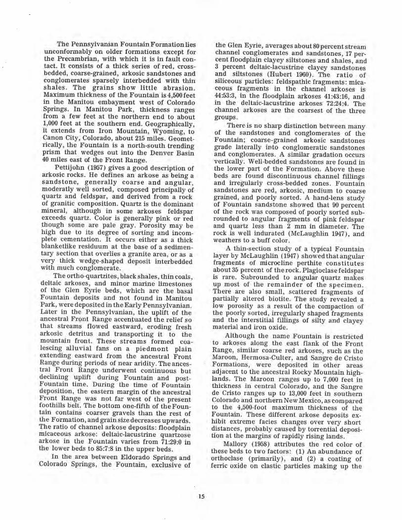
Soils in limestone formations generallyreflect the color of the parent rock, and in theMadison Limestone they are usually a richbrown. Scattered over the surface of Madison-derived soils are rounded flint or cherty bouldersgreater than 1 inch in diameter. This soil ishigh in clay and moisture-holding capacity, andalso in nitrogen, potassium, phosphorus, andorganic matter; the pH is 8.0 (tables 2, 3).
Table 2.—Physical characteristics of the top 6 inches of Manitou Park so i ls (Smith 1971)
Soil Parent material andNo. aspect
12 Madison LimestoneNWSW
4 Williams Canyon LimestoneNWSW
6 Fountain ArkoseNWSW
1 Pikes Peak GraniteNWSW
Soil texture
Sand Silt
36 3231 41
31 4539 39
44 3365 19
47 3655 36
Table 3. — Chemical characteristics of the top
1 Parent material
12 Madison LimestoneNWSW
4 Will i a m s Canyon LimestoneNWSW
6 Fountain ArkoseNWSW
1 Pikes Peak Granite• NW
SW
pH
7.88.1
8.08.0
6.97.3
7.06.6
Conductivity
mnho/cm
0.70.7
0.80.9
0.50.6
0.60.6
class
Clay
3228
2422
2316
179
6 inches
Organicmatter
- - -
5.46.1
7.68.8
2.23.4
5.75.6
Soil
1/3 atm
moisture characteristics
15 atm Available water
27.4 15.226.7 14.0
30.1 16.731.1 18.6
18.0 10.314.7 8.0
24.817.4
of Manitou
Totalnitrogen
(N)
Percent -
0.200.24
0.290.33
0.060.10
0.110.13
15.1
Park
Lime
6.1
soils (Smith
Phosphorus(P2°s)
12.212.7
13.412.5
7.76.7
9.711.3
1971)
Potassium(K20)
Pounds per acre
3.611.9
13.012.3
0.40.8
0.60.6
7278
2629
2112
3119
958766
450508\7
383
438279
14
The Pennsylvanian Fountain Formation liesunconformably on older formations except forthe Precambrian, with which it is in fault con-tact. It consists of a thick series of red, cross-bedded, coarse-grained, arkosic sandstones andconglomerates sparsely interbedded with thinshales. The grains show little abrasion.Maximum thickness of the Fountain is 4,500 feetin the Manitou embayment west of ColoradoSprings. In Manitou Park, thickness rangesfrom a few feet at the northern end to about1,000 feet at the southern end. Geographically,it extends from Iron Mountain, Wyoming, toCanon City, Colorado, about 215 miles. Geomet-rically, the Fountain is a north-south trendingprism that wedges out into the Denver Basin40 miles east of the Front Range.
Pettijohn (1957) gives a good description ofarkosic rocks. He defines an arkose as being asandstone, generally coarse and angular,moderatly well sorted, composed principally ofquartz and feldspar, and derived from a rockof granitic composition. Quartz is the dominantmineral, although in some arkoses feldsparexceeds quartz. Color is generally pink or redthough some are pale gray. Porosity may behigh due to its degree of sorting and incom-plete cementation. It occurs either as a thickblanketlike residuum at the base of a sedimen-tary section that overlies a granite area, or as avery thick wedge-shaped deposit interbeddedwith much conglomerate.
The ortho-quartzites, black shales, thin coals,deltaic arkoses, and minor marine limestonesof the Glen Eyrie beds, which are the basalFountain deposits and not found in ManitouPark, were deposited in the Early Pennsylvanian.Later in the Pennsylvanian, the uplift of theancestral Front Range accentuated the relief sothat streams flowed eastward, eroding fresharkosic detritus and transporting it to themountain front. These streams formed coa-lescing alluvial fans on a piedmont plainextending eastward from the ancestral FrontRange during periods of near aridity. The ances-tral Front Range underwent continuous butdeclining uplift during Fountain and post-Fountain time. During the time of Fountaindeposition, the eastern margin of the ancestralFront Range was not far west of the presentfoothills belt. The bottom one-fifth of the Foun-tain contains coarser gravels than the rest ofthe Formation, and grain size decreases upwards.The ratio of channel arkose deposits: floodplainmicaceous arkose: deltaic-lacustrine quartzosearkose in the Fountain varies from 71:29:0 inthe lower beds to 85:7:8 in the upper beds.
In the area between Eldorado Springs andColorado Springs, the Fountain, exclusive of
the Glen Eyrie, averages about 80 percent streamchannel conglomerates and sandstones, 17 per-cent floodplain clayey siltstones and shales, and3 percent deltaic-lacustrine clayey sandstonesand siltstones (Hubert 1960). The ratio ofsiliceous particles: feldspathic fragments: mica-ceous fragments in the channel arkoses is44:53:3, in the floodplain arkoses 41:43:16, andin the deltaic-lacustrine arkoses 72:24:4. Thechannel arkoses are the coarsest of the threegroups.
There is no sharp distinction between manyof the sandstones and conglomerates of theFountain; coarse-grained arkosic sandstonesgrade laterally into conglomeratic sandstonesand conglomerates. A similar gradation occursvertically. Well-bedded sandstones are found inthe lower part of the Formation. Above thesebeds are found discontinuous channel fillingsand irregularly cross-bedded zones. Fountainsandstones are red, arkosic, medium to coarsegrained, and poorly sorted. A hand-lens studyof Fountain sandstone showed that 90 percentof the rock was composed of poorly sorted sub-rounded to angular fragments of pink feldsparand quartz less than 2 mm in diameter. Therock is well indurated (McLaughlin 1947), andweathers to a buff color.
A thin-section study of a typical Fountainlayer by McLaughlin (1947) showed that angularfragments of microcline perthite constitutesabout 35 percent of the rock. Plagioclase feldsparis rare. Subrounded to angular quartz makesup most of the remainder of the specimen.There are also small, scattered fragments ofpartially altered biotite. The study revealed alow porosity as a result of the compaction ofthe poorly sorted, irregularly shaped fragmentsand the interstitial fillings of silty and clayeymaterial and iron oxide.
Although the name Fountain is restrictedto arkoses along the east flank of the FrontRange, similar coarse red arkoses, such as theMaroon, Hermosa-Culter, and Sangre de CristoFormations, were deposited in other areasadjacent to the ancestral Rocky Mountain high-lands. The Maroon ranges up to 7,000 feet inthickness in central Colorado, and the Sangrede Cristo ranges up to 13,000 feet in southernColorado and northern New Mexico, as comparedto the 4,500-foot maximum thickness of theFountain. These different arkose deposits ex-hibit extreme facies changes over very shortdistances, probably caused by torrential deposi-tion at the margins of rapidly rising lands.
Mallory (1958) attributes the red color ofthese beds to two factors: (1) An abundance oforthoclase (primarily), and (2) a coating offerric oxide on clastic particles making up the
15

rock. McLaughlin (1947) attributes the red colorto the presence of iron oxides, which may beonly a stain on the grain surfaces or may occuras interstitial cementing material.
Soils developed from the Fountain aresimilar to those developed from the Pikes PeakGranite, from which it was largely derived. Bothare infertile (table 3). The pedestals found inthe area do not appear to have been importantin the development of the soil.
Soils on northerly and easterly exposureshave more pronounced zones than those onsoutherly and westerly exposures. Southerlyexposures also generally have a ponderosa pinecover, while northern slopes contain mostlyDouglas-fir, a few ponderosa pines, and anoccasional aspen.2
In general, soil erosion in the Rocky Moun-tains is severe only where remnants of the pre-Wisconsin soils are extensive. The differencebetween the soils of pre-Wisconsin, Wisconsin,and Recent age in the Rockies are best shownby the difference in weathering of the morainesand other deposits of those ages. In Recentdeposits, pebbles are fresh; in Wisconsindeposits they may have a weathered rind; andin pre-Wisconsin deposits they may be alteredto clay (Hunt 1967).
Overlying the Fountain Formation andcovering the major portion of the Manitou ParkBasin is an accumulation of coarse, angularmaterial which has either been washed down-slope from the granitic and Paleozoic outcrops,or deposited by intermittent streams duringheavy rains and spring runoff. These depositsare approximately 10 to 25 feet thick. In theManitou Experimental Forest, these depositsform a large alluvial fan with an apex in thePaleozoic hogbacks of sec. 25, T. 11 S., R. 69 W.(Sweet 1952), just southeast of the Forest. Onthe west side of the Basin the gravels are com-posed of granitic detritus with fragments of aultbreccia intermixed, while on the east side thereis an admixture of lower Paleozoic material withthe granitic debris. The deposits are Quaternaryin age and cover the Ute Pass Fault linethrough most of its extent. The lateral movementof the fault activity must antedate the alluvialdeposits.
^ Fox, C. J., J. Y. Nishimura, R. F. Bauer, C. R.Armstrong, and R. F. Willmot. 1962. Soil survey reportof wildlife habitat study area, Manitou ExperimentalForest, Colorado. 26 p. (Unpublished report on file atRegion 2 office, USDA For. Serv., Denver, Colo.)
Igneous Petrology
Pikes Peak Granite is the only Precambrianrock in the area. In Manitou Park it is part ofa large batholith of coarse, even-grained toporphyritic pink rock consisting mostly of micro-cline and quartz.
Biotite occurs in clusters and large flakesand is the most important accessory mineral.Other accessory minerals are oligoclase, feldspar,zircon, apatite, allanite, magnetite, fluorite, andrutile. The red-pinkish color of the rock is dueto a pigment of hydrous iron oxide whichcolors the feldspars. The feldspar and quartzgrains are relatively large, and conspicuousfeldspar phenocrysts are common, often attain-ing a diameter of several inches. Some areas ofPikes Peak Granite, however, contain feldspargrains little more than 0.25 inch long. Percentageof constituents, according to Ma thews (1900), isquartz 33.4 percent, microcline feldspar 53.3percent, biotite 10.7 percent, and oligoclase feld-spar 2.6 percent.
Fine-grained granite dikes cut the Pikes PeakGranite in places. They are red to pink in colorand very poor in mica. Feldspars dominate inthese dikes (Peterson 1964).
Also cutting the Pikes Peak Granite are anumber of pegmatite dikes. The pegmatitescontain microcline, orthoclase, albite, oligoclase,quartz, biotite, muscovite, and accessory min-erals in very large individual grains, oftensegregated in different parts of the dikes. Theyare most abundant near the Platte River.
Age determinations based on Pb-U ratiosgive an age of about 1 billion years for thePikes Peak Granite (Fowler 1952). This comparesto Hutchinson's (1964) finding of 995 millionyears for the porphyritic aplitic facies of thePikes Peak batholith.
Pikes Peak Granite has basically the samecomposition and grain size as the other majorgranites of the Front Range. However, PikesPeak Granite is distinctively more susceptibleto weathering and erosion than the BoulderCreek or Silver Plume Granites. It weatherstypically into rounded masses, with greatcurving plates breaking away from the dome-like outcrops in the process of exfoliation.Weathering by disintegration forms an angulargravel that is widely distributed as a mantle onlong, low divides. Weathering of the granite isso general that only about 10 percent of thearea in Manitou Park underlain by granite con-tains outcrops.
Biotite is the most easily decomposed of theconstituent minerals of the granite. As itweathers, iron is set free, staining the other
16

minerals. The weathered rock shows everygradation from green through pink to deep red,the red being caused by iron oxide staining.The depth of the weathered layer averages 25feet, due both to ease of weathering and thefact that some of the surfaces were subject toerosion during Cambrian times.
The terraces in Manitou Park are coveredwith gravels derived mostly from Pikes PeakGranite, though the bases of the terraces havesome reworked Fountain material mixed in,since they are underlain by Fountain beds. Theterrace deposits also weather very easily.
Soils developed from Pikes Peak Graniteare pinkish or reddish in the lower parts oftheir profiles as an inheritance from the parentmaterials. The percentage of particles greaterthan 2 mm in size is greater than for any ofthe soils developed on sedimentary layers inthe area (Smith 1971). The soil is a gravelly,sandy loam with a low clay content. Availablewater is slightly higher than for the Fountain-derived soil. Nitrogen, potassium, and phos-phorus are deficient. The surface soil is neutralor slightly acidic, with acidity increasing withdepth (tables 2, 3).
Structure
Manitou Park is a fault outlier: an outcropof younger rocks isolated by faulting in an areaof older rocks. The sedimentary structure con-sists of a westward-dipping homocline or mono-cline except for sharp drag along the fault atthe west edge of the block.
The dominant structures in Manitou Parkare faults. The area is bounded on the east byMt. Deception Fault (Fowler 1952), and on thewest by the Ute Pass Fault. In the Basin itself,there are no folds. The most significant struc-tural feature in the area is the Ute Pass Faultzone, about 30 miles long and 800 to 1,700 feetwide. Fine-grained, calcium-rich breccia is foundin the northern part of the fault zone, whilelarger uncemented breccia is found in the centraland southern parts. In places, the zone can betraced by the presence of weathered or iron-stained belts in the granite. The fault plane isalmost vertical with a possible eastward dip.Both horizontal and vertical movement hasoccurred along this fault plane. The west blockhas been upthrown with respect to the eastblock, with an estimated maximum vertical dis-placement of up to several thousand feet andminimum of several hundred feet. The horizon-tal displacement is not known. On the westernside, the upthrown block of Pikes Peak Graniteforms a prominent fault scarp.
There was a tremendous amount of shearingin the Ute Pass Fault zone. Movement began inthe Precambrian and continued until Miocene-Pliocene time. Sweet (1952) states that thefaulting is late Tertiary or early Pleistocene.
The Mt. Deception Fault zone on the eastside of Manitou Park is closely related to theUte Pass Fault zone. The trends of both faultzones are parallel for most of their extent. Thesediments dip most steeply just to the west ofthe fault and then flatten out farther west. Thewest block is downthrown, probably a high-anglereverse fault dipping steeply to the east. Otherminor faults in the area include the TroutCreek Fault, which extends for about 5 miles ina north-south direction halfway between the UtePass and Mt. Deception Faults, and the FishHatchery Fault, which connects the Ute PassFault with the Trout Creek Fault. Scott3 re-ferred to the Mt. Deception Fault as a branchof the Ute Pass Fault. Harms (1965) refers tothe east side of the Manitou Park Basin as amonoclinal flexure rather than a fault.
Geologic History
The major events in the geologic historyof the Manitou Park area, as determined bySweet (1952), are:
1. Development of a peneplain on the sur-face of the Pikes Peak Granite before Late Cam-brian time.
2. Advance of the Late Cambrian sea fromthe west around the margins of the FrontRange highland, and deposition of the SawatchSandstone.
3. Change in depositional conditions with-out uplift, and deposition of the Early OrdovicianManitou Limestone.
4. Retreat of the sea at the end of Manitoudeposition and erosion of the area during theremainder of the Ordovician, Silurian, and prob-ably part of the Devonian.
5. Submergence in Devonian time, anddeposition of the Williams Canyon Limestonesand Sandstones.
6. Emergence and erosion during the LateDevonian and possibly the very Early Mis-sissippian.
7. Submergence in the Early Mississippian,and deposition of the Madison Limestone.
Personal communication with Glenn R. Scott, U. S.Geological Survey, Denver Federal Center, Colorado, 1972.
17

8. Uplift with mountain-building during theEarly Pennsylvanian, and deposition of theFountain Formation as a thick series of coarseclastic sediments around the margins of themountain mass.
9. No record of the remainder of thePaleozoic and the entire Mesozoic.
10. A period of uplift and mountain-buildingat the close of the Cretaceous. The foldingwhich occurred at this time probably formedthe Manitou Park syncline.
11. Peneplanation on the surface of the FrontRange mountains, and deposition of a thickseries of stream gravels in Manitou Park bystreams flowing eastward across the erosionalsurface.
12. Late Tertiary uplift.13. Active stream erosion during the Quater-
nary, with development of narrow erosionalsurfaces along the major streams of ManitouPark during the Pleistocene.
Physiography
The topography of the area is mature,highly dissected, and well drained. -The streamsform a dendritic pattern in the east wherehomogeneous outcrops of granite are found.Here the relief is complex, with drainagewaysextending almost to the tops of the mountains,leaving only narrow summits. Limestone terrainis characterized by a trellis or blocky drainagesystem. Secondary drainages many times branchout perpendicular to the main drainage, formingblocks of gently sloping or rounded hills.
Broscoe (1959) divides the area in and nearManitou Park into four geomorphic districts:(1) The Pikes Peak Granite-pre-Pennsylvanianoutcrop area of the Rampart Range, which herefers to as the Rampart Range granite area;(2) the widely spread outcrop area of PikesPeak Granite west of the Ute Pass Fault, whichhe calls the Rule Creek granite area; (3) anarea of widespread Oligocene gravels in thevicinity of the town of Divide; and (4) the low-land of the Manitou Park Basin which is under-lain by the Fountain Formation.
Both the Rampart Range and Rule Creekgranite areas are heavily forested. On weather-ing, Pikes Peak Granite forms large, roundedmasses, which are surrounded by a very coarsegravel called grus. The soil developed on thismaterial is very coarse and permeable. Inseveral places, such as at the head of WhiteSpruce Gulch, drainage ditches from the Ram-part Range Road have been diverted into naturaldrainageways. Increased discharge at the headof the washes has caused active gullying. With
the exception of man-disturbed areas, however,there is little erosion in the granite area. Anyinequilibrium in the granite terrain is more inthe direction of alluviation, rather than gullying.Broscoe (1959) considers the Rampart Rangeand Rule Creek areas to be unlikely sources forthe sediment presently being deposited inManitou Park Lake.
The area of gravel near Divide is similar tothe granite areas, with its gravelly soil and lackof erosion, except for the man-disturbed areas.Therefore, Broscoe (1959) considers the mostlikely source of sediment in the area to be theManitou Park Basin, with its extensive alluvialterrace and floodplain deposits.
Three terraces are found in the ManitouPark Basin (fig. 6), an oldest high terrace, anintermediate terrace, and a youngest lowterrace (Broscoe 1959). These terraces aredeveloped on areas underlain by the FountainFormation. The highest surface is preservedonly in scattered ridges and benches. Remnantsof this terrace stand approximately 80 to 100feet above the intermediate terrace. All of theterraces are cut by numerous small channels.Many of the courses of the Trout Creek drain-age system are underlain by Quaternaryalluvium. Sweet (1952) called the highest terracegravel the Woodland Park Formation and con-sidered it to be of Tertiary age, though hethought the terrace developed in the Pleistocene.
Most of the second or intermediate terraceremnants west of highway 67 are near the westboundary of the Experimental Forest. The oldeststage of physiographic development on thelowest terrace, with a relatively flat slope, isfound west of but near the highway. Here theridges have been worn down to produce agently rolling slope. West of the oldest stage,the low terrace consists of a mature, much dis-sected area with many ridges and gullies.Further west is a youthful area where ridgesand gullies are just beginning to develop. Theslopes on the different terraces vary from 4° to8° with a trend of about N. 70° E. This trendaccounts for the general northeast trend of theridges and gullies. All three terraces wereoriginally cut in Fountain arkose.
Pedestals, weirdly shaped remnants of theFountain arkose, are scattered throughout westof highway 67 and around Manitou Park Lake.They represent remnants of the next higherterrace which has been eroded away in thesurrounding area. Pedestals are not as common
** Retzer, John L. 1949. Soils and physical conditionsof Manitou Experimental Forest. 123 p. (Unpublishedreport on file at Rocky Mt. For. and Range Exp. Stn.,USDA For. Serv., Fort Collins, Colo.)
18
east of the highway, but outcrops of Fountainarkose are numerous, especially in northernportions of the area. Since the pedestals arebeing worn down, it is not possible to deter-mine their original height and, therefore, theheight of the next higher terrace in the adja-cent area. Currently, the pedestals range from20 to 50 feet in height, and strike approximatelynorth-south and dip to the west. It is notknown just why the pedestals remained whilesurrounding layers were eroded away, but onepossibility could be that the pedestals have aslightly more durable cement than did theadjacent layers.
The pedestals, with their orange colorstanding in sharp contrast against the greenbackground of the surrounding forest, add tothe scenic beauty of the area. Near theRainbow Falls Road, Trout Creek has cutthrough an outcrop of Fountain arkose and leftorange cliffs about 100 feet high. Also, inMissouri Gulch the stream has cut a canyonabout 150 feet deep, exposing the contactbetween the Sawatch Sandstone and the PikesPeak Granite.
Setting of Manitou Park in the Front Range
Manitou Park is unique in that it is a struc-turally depressed block containing a Paleozoicsedimentary formation, while the otherparklikeareas in the Front Range were formed byerosional processes in crystalline rocks. Thesoils of Manitou Park are mostly of graniticorigin, and, therefore, differ from other soilsin the Front Range only because of theirderivation from the distinctive Pikes PeakGranite. The erosive qualities of soils derivedfrom Pikes Peak Granite make it imperative thatextreme caution be exercised whenever anyalteration of the surface profile is planned forroad construction, housing developments, orother disturbance.
Reestablishment of shrubs and grasses isvery slow on Pikes Peak and Fountain-derivedsoils. Once these plants are removed, the soilbecomes greatly weakened. The soils are heldtogether mostly by mats of needles droppedfrom the trees. Tramping on these soils isharmful and should be minimized to protectthe area. Residential development would mostlikely cause a severe erosional problem. A goodidea of the severe erosion potential in this areacan be obtained by observing residential devel-opment just south of the town of Divide.
These restrictions apply not only to theManitou Experimental Forest lands, but to anyFront Range lands having soils derived fromPikes Peak Granite. The sedimentary forma-tions in the area of the Experimental Forestare encountered nowhere else in the FrontRange and are of minimal importance.
Literature Cited
Addy, Richard V.1949. Cambrian stratigraphy of the southern
Front Range, Colorado. Geol. Soc. Am.Bull. 60:1959. (Abstr.)
Berg, Robert R., and Reuben James Ross, Jr.1959. Trilobites from the Peerless and Man-
itou formations, Colorado. J. Paleontol.33:106-119.
Boos, M. F., and C. Maynard Boos.1957. Tectonics of eastern flank and foothills
of Front Range, Colorado. Am. Assoc. Pet.Geol. Bull. 41:2603-2676.
Boyer, Robert E.1962. Petrology and structure of the southern
Wet Mountains, Colorado. Geol. Soc. Am.Bull. 73:1047-1069. ,
Brainerd, A. E., H. L. Baldwin, Jr., and I. A.Keyte.1933. Pre-Pennsylvanian stratigraphy of
Front Range in Colorado. Am. Assoc. Pet.Geol. Bull. 17:375-396.
Broscoe, Andy J.1959. Quantitative analysis of longitudinal
stream profiles of small watersheds. Colum-bia Univ. Dep. Geol. Tech. Rep. 18, Con-tract N60NR 271-30, 73 p.
Butler, Charles R.1949. Geology of the northern part of the
Sangre de Cristo Mountains, Colorado. Geol.Soc. Am. Bull. 60:1959-1960. (Abstr.)
Crosby, W. 0.1895. Sandstone dikes accompanying the
great fault of Ute Pass, Colorado. Bull.Essex Inst. 27:113-147.
Fowler, W. A.1952. Geology of the Manitou Park area,
Douglas and Teller Counties, Colorado. M.S. Thesis, 92 p. Univ. Colo., Boulder.
Harms, J. C.1964. Structural history of the southern Front
Range. The Mt. Geol. 1:93-101.Harms, John C.
1965. Sandstone dikes in relation to Laromidefaults and stress distribution in the southernFront Range, Colorado. Geol. Soc. Am.Bull. 76:981-1002.
19
Hedge, Carl E., Zell E. Peterman, and W. O.Braddock.1967. Age of the major Precambrian regional
metamorphism in the Northern FrontRange, Colorado. Geol. Soc. Am. Bull.78:551-558.
Hubert, John F.1960. Syngenetic bleached borders on detrital
red beds of the Fountain formation, FrontRange, Colorado. Geol. Soc. Am. Bull.71:95-98.
Hunt, Charles R.1967. Physiography of the United States.
480 p. W.H. Freeman and Co., San Francisco.Hutchison, Robert M.
1964. Time-span and field time relations ofPikes Peak batholith and its wall rocks.Geol. Soc. Am. Spec. Pap. 76:277. (Abstr.)
Knopf, Adoph.1936. Igneous geology of the Spanish Peaks
region, Colorado. Geol. Soc. Am. Bull.47:1727-1784.
Litsey, Linus R.1958. Stratigraphy and structure of the north-
ern Sangre de Cristo Mountains, Colorado.Geol. Soc. Am. Bull. 69:1143-1177.
Lovering, T. S., and E. N. Goddard.1950. Geology and ore deposits of the Front
Range, Colorado. U.S. Geol. Surv. Prof.Pap. 223, 319 p, 120 illus.
McLaughlin, Kenneth P.1947. Pennsylvanian stratigraphy of the Col-
orado Springs quadrangle, Colorado. Am.Assoc. Pet. Geol. 31:1936-1981.
Maher, John C.1950. Detailed sections of pre-Pennsylvanian
rocks along the Front Range of Colorado.U.S. Geol. Surv. Circ. 68, 20 p.
Mallory, W. W.1958. Pennsylvanian coarse arkosic redbeds
and associated mountains in Colorado.
of true mountain-
p. 17-20. In Rocky Mt. Assoc. Geol., Symp.on Pennsylvanian rocks of Colorado andadjacent areas.
Mathews, Edward B.1900. The granitic rocks of the Pikes Peak
quadrangle. J. Geol. 8:214-240.Moench, R. H., J. E. Harrison, and P. K. Sims.
1962. Precambrian folding in the IdahoSpring-Central City area, Front Range, Col-orado. Geol. Soc. Am. Bull. 73:35-58.
Peterson, Warren L.1964. Geology of the Platte Canyon quad-
rangle, Colorado. U.S. Geol. Surv. Bull.1181-C, p. C1-C23.
Pettijohn, F. J.1957. Sedimentary rocks. 2d ed. 718p. Harper
and Bros., New York.Smith, Dwight.
1971. Growth responsesmahogany (Cercocarpus montanus) on foursoil types within the Front Range of Colo-rado. Ph.D. Diss., 150 p. Utah State Univ.,Logan.
Sweet, W. C.1952. Geology of the southern part of Man-
itou Park, Colorado. M.S. Thesis, 94p.Univ.Iowa, Iowa City.
Swett, Keene.1964. Petrology and paragenesis of the
Ordovician Manitou Formation along theFront Range of Colorado. J. Sediment. Pet.34:615-624.
Thornbury, William D.1965. Regional geomorphology of the United
States. 609 p. John Wiley and Sons, Inc.,New York.
Van Tuyl, F. M., and T. S. Lovering.1934. Physiographic development of the
Front Range. Geol. Soc. Am. Bull.46:1291-1350.
Agriculture—CSU, Ft. Collins 20