geology of the alberni - nanaimo lakes … · the geology and structure of tarea are summarized in...
TRANSCRIPT
GEOLOGY OF THE ALBERNI - NANAIMO LAKES AREA, VANCOUVER ISLAND*
(92F/lW, 92F/2E and part of 92F/7)
By N.W.D. Massey and S.J. Friday
KEYWORDS: Vancouver Island, Sicker Group, Duck Lake Formation, Cowichan uplift, thrusts, massive sulphide, gold.
INTRODUCTION A 4.year program of 150 000.scale regional mapping was
initiated by the Geological Survey Branch in southern Van- couver Island in 1986, under the CanadaiBritish Columbia Mineral Development Agreement. The program was planned to cover three I:50 000 NTS sheets centred on the main Sicker Group outcrop area within the Cowichan uplift (Fig- ure l-8-1). The 1988 field season saw the completion of the field component of this project. Previous mapping in the Cowichan Lake (9X/16) and Duncan (928113) areas has been reported on (Massey and Friday, 1987, 1988) and released as Open Files (Massey ef nl., 1987, 1988).
During 1988, fieldwork was concentrated in the area around Fourth Lake (92iFl W) and west to Albemi Inlet (92F/2E), extending northwards to Home Lake (92Fi7). Road access is good with Highway 4 passing through the northern part of the area and the Bamfield road running along the western margin. An extensive network of logging roads, in various states of upkeep, provides access along most of the valleys and adjacent slopes.
PREVIOUS WORK The Sicker Group was first defined as the Mount Sicker
Series by Clapp (Clapp, 1912; Clapp and Cooke, 1917) within the Duncan area, although erroneously interpreted as younger than the Karmutsen Formation (Vancouver Series). Later workers in the Buttle Lake and Cowichan Lake areas recognized that the Sicker Group is indeed older (Gunning, 1931; Fyles, 1955). Muller and colleagues mapped large portions of Vancouver Island including the Albemi area (Muller and Carson, 1969). Detailed investigations of the China Creek area were reported on by Stevenson (1945).
Stratigraphic studies of the Sicker Group were conducted by Yale (1963, 1964, 1969) and Muller (1980). A major revision of the stratigraphy of the Sicker Group of the Cowichan uplift has been suggested by Sutherland Brown, based on I:50 000 mapping in the Albemi-Barnfield corridor undertaken by the Geological Survey of Canada in support of the LITHOPROBE I Project (Sutherland Brown and Yorath, in preparation; Sutherland Brown et al., 1986). A similar revision has also been made independently by Juras in the Buttle Lake uplift (Juras, 1987). Biostratigraphic and radio- metric dating of the rocks of southern Vancouver Island has been summarized by Muller and Jeletzky (1970), Brandon et a[., (1986), and Armstrong et al., (unpublished preprint).
REGIONAL SETTING The Albemi-Nanaimo Lakes area is situated at the north-
western end of the Cowich.an uplift, one of a series of major geanticlines constituting the structural ~fabric of southern Vancouver Island (Figure l-8-1). The area lies within the Wrangellia terrane, which on Vancouver Island comprises three thick volcano-sedimentary cycles (Paleozoic Sicker Group, Upper Triassic Vancouver Group and the Jurassic Bonanza Croup) overlapped by late Creta~xous sedimenls of the Nanaimo Group. The geology and structure of the tarea are summarized in Figures I-8-2 and l-8-3.
STRATIGRAPHY The oldest rocks in the area belong to the Paleozoic Sit:ker
Group (Figure l-8-2) which contains volcanic and sedimen- tary units ranging in age from Middle Devonian(?) I,O Early Permian. These are intmdc:d by mafic sills and dykes coeval with overlying basaltic volcanics of the Late Triassic .<a~- mutsen Formation. Micritic limestone of the Quatsino For- mation and volcanic rocks of the Early Jurassic Bonanza Group overlie the Karmutsen Formation. All these sequences have been subsequently intruded by granodioritic stocks of the Middle Jurassic Island intrusions. La Cretaceous sedi- ments of the Nanaimo Group lie unconformably on the older sequences and are the principal host to Late(?) Ewene porphyry sills.
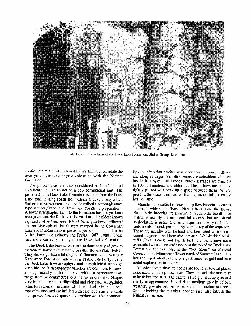
SICKER GROUP
Since the initial work of Clapp (1912) there have been several attempts to formally subdivide the Sicker Group. Muller (1980) proposed four subdivisions which, in ascend- ing stratigraphic order, are the Nitinat Fol:mation, the N:yra Formation, an informal sediment-sill unit and the Buttle Lake Formation. Recent paleontological and ratlio- chronological studies (Brandon er al., 1986). coupled with newer mapping (Sutherland Brown et al., 1986; Sutherland Brown and Yorath, 1985; Juras, 1987), have thrown some doubt on these subdivisions and their uniwrsal appticabi .ity. New stratigraphic subdivisions have been proposed by Sutherland Brown for the Cowichan uplift, based on work in the Albemi area (Sutherland Brown and Yorath, in prepua- tion). Apart from one major change outl,ined below, these formationat subdivisions hwe also proven to be applicable in the Cowichan Lake and Duocan areas and have been adopted for this project (Massey and Friday, 1988; Massey et al., 1987, 1988). A composite stratigraphic section for the Sicker Group in the Albemi-Nanaimo Lakes area is illustrated in Figure I-8-4.

Sutherland Brown has also suggested that the Sicker Group be redefined to include only the lower volcanic- volcaniclastic rocks, with the younger epiclastic sediments and limestones comprising a new Buttle Lake Group. There is great merit in this suggestion although, for convenience, the older, broader usage of “Sicker Group” has been retained here.
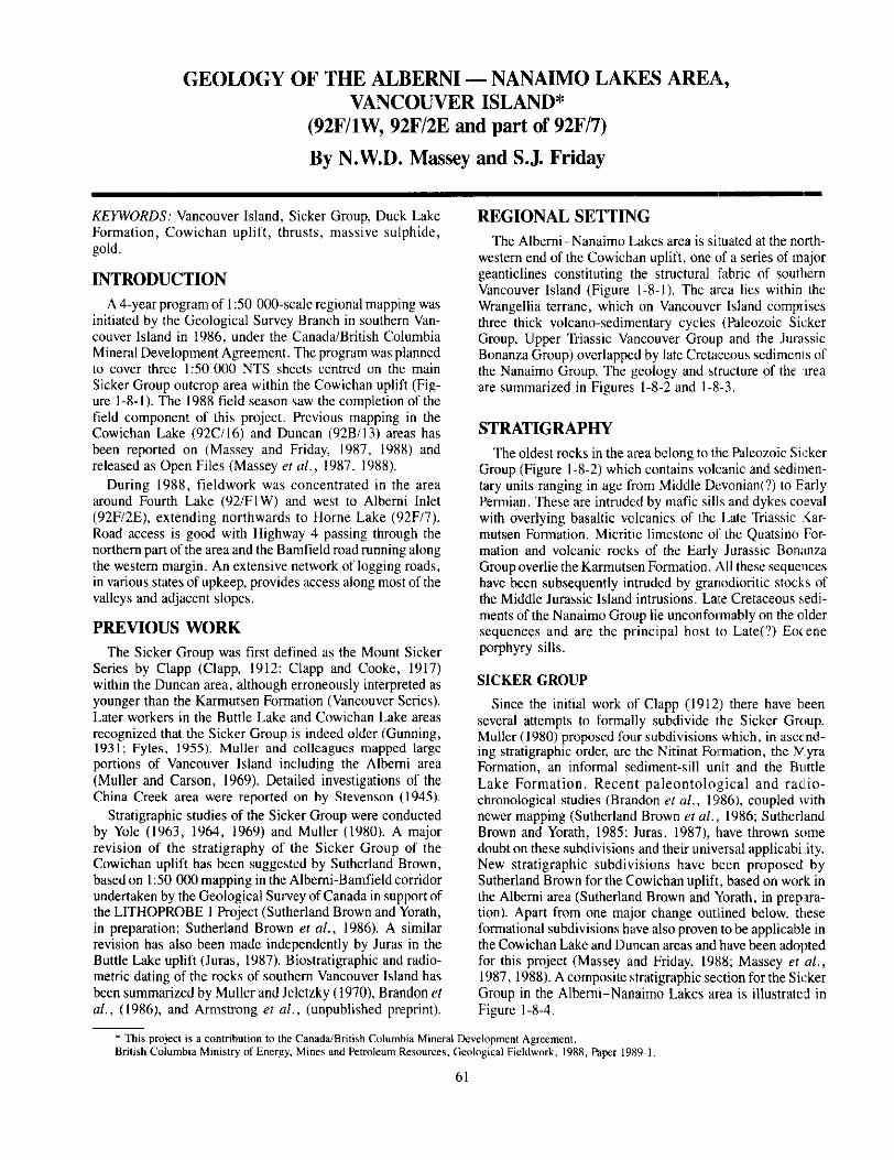
DUCK LAKE FORMATION This is a newly defined stratigraphic unit within the Sicker
Group, comprising a dominantly pillowed basalt sequence. Amygdaloidal basalts within the Sicker Group of the Cowichan uplift were first described by Fyles (1955) but were not formally separated as a stratigraphic unit. The
pillow laws were ascribed by Muller and Carson (I 969) to the Karmutsen Formation and to either the Sicker Group or Kamutsen Formation by Laanela (1966). Sutherland Brown (1986, and Sutherland Brown and Yorath, in preparation) recognized that these pillows were of Sicker Group age but included them within the McLaughlin Ridge Formation.
Detailed mapping on behalf of Westmin Resources Lim- ited on the Debbie property in the early 1980s documented a package of pillowed basalts that passed up through a discon- tinuous unit of cherts and felsic tuffs into pyroxene- plagioclase-phyric flows and volcaniclastics (R. Walker, per- sonal communication, 1988). The whole package was thought to be part of the Myra Formation, using Muller’s terminology, and younger than the Nitinat Formation. The results of mapping on a more regional scale by the authors
50
126’ 125’ 124’ I I 1
r-32
w Sicker Group
Buttle Lake Uplift Cowichan Uplift ” Nanoose Uplift
Port Alberni
49’
0 , 2;5 5p
Kilometres I
WI’ dL!l Victoria 0
126’ 125’ 124’
. 49’
Figure 1-8-I: Location of the Sicker Project area, southern Vancouver Island, in relation to the three major geanticlinal uplifts cored by Sicker Group rocks (after Brandon er al.. 1986). 1986.88 field seasons are indicated.
62

12445 n430 124’15
Figure l-8-2: Geology of the Albemi-Nanaimo Lakes ama,
NITINAT FORMATION MCLAUGHLIN RIDGE FORMATION
Overlying the Duck Lake Formation is the Nitinat Forma- tion, a volcanic package characterized by pyroxene-feldspar- porphyritic basaltic andesites, typically occurring as ag- glomerates, breccias, lapilli tuffs and crystal tuffs. However, pyroxene-phyric, amygdaloidal, pillowed and massive flows are developed in several areas, for example Nitinat pdss and the West Fork of the Nitinat River. Pyroxenes may be large, up to I centimetre in diameter, euhedral to subhedral, and comprise 5 to 20 per cent of the rock. They are variably uralitized. Plagioclase is often as abundant as pyroxene, but phenocrysts are usually smaller, ranging up to 5 millimetres in diameter. Amygdules present in flows and clasts in coarser pyroclastics are infilled with chlorite, quartz, epidote or calcite. Non-pyroxene-phyric breccia, tuffaceous sandstone and laminated tuff are also found locally, interbedded with the pyroxene-phyric rocks.
This volcanic unit is equivalent to the Nitinat Formation of Muller ( 1980).
1 The Nitinat Formation passes upwards transitionally into
the McLaughlin Ridge Formation, a sequence of vol- caniclastic sediments dominated by thickly bedded, massive tuffites and lithic tuffites with interbedded laminated tuffaceous sandstone, siltstone and argillite (Figure l-8-4). Associated breccias and lapilli tuffs are usually heterolithic and include aphyric and porphyritic (feldspar, pyroxene, hornblende) lithologies, commonly mafic to intermediate in composition. Felsic tuffs are rare.
The McLaughlin Ridge Formation is equivalent to the lower parts of the Myra Formation of Muller (1980).
CAMERON RIVER FORMATION
The upper part of the Sicker Group is made up of a dominantly epiclastic and bioclastic sedimentary sequence comprising the Cameron River, Mount Mark and St Mary’s

Lake formations (Figure l-8-4). This sedimentary package is apparently conformable on the underlying volcanics along the northeastern limb of the Cowichan uplift, for example, in the upper Cameron River valley and the Chemainus valley, but is unconformable along the southwestern limb both in the Albemi and Cowichan areas.
The Cameron River Formation comprises mostly thin- bedded, often cherty sediments. These vary from green and red ribbon cherts, black chetty argillites, green and white cherty tuffs, grey and green siltstones and argillites, to thicker bedded green volcanic sandstones. Chert breccias with a sandy matrix occur near the base of the formation; intercalated argillite and calcarenite beds up to I metre thick, dominate the upper part.
The Cameron River Formation is equivalent to the upper parts of Muller’s Myra Formation together with the sedi-
ments of the informal xdiment-sill unit (Muller, lS80). Chronologically, it is comlative, in part, with the volcanics of the Thelwood and Flower Ridge formations of the Rattle Lake upift (Juras, 1987) :and probably with units PSc and PSd of the Nanoose uplift (Sutherland I3rown and Yorath, 1985).
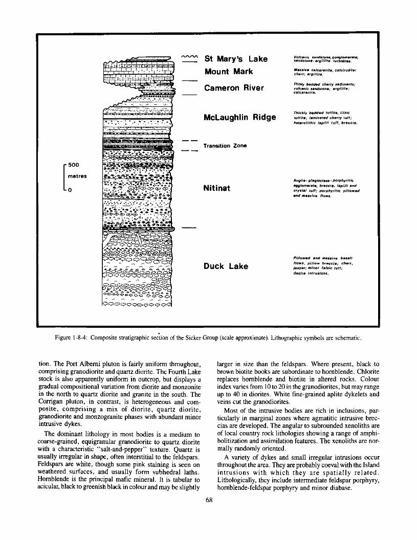
MOUNT MARK FORMATION The Mount Mark Formation conformably overlies and
laterally interfingers with the Cameron River Formation. However, in places along the southwest limb of the uplift, for example west of Rift Creek and on the south slope,; of Douglas Peak. it lies dirc:ctly and unconformably on the lower Sicker Group volcanics.
The formation consists of massive limestone beds ,with minor argillite and chat interbeds. The limestones are well
65

bedded, varying from about 15 centimetres up to about 5 metres thick (Plate l-8-4). They are predominantly bio- elastic calcarenites and calcimdites. rich in broken crinoid stems ranging up to 2 centimetres in diameter. Bryozaa, brachipods, pelecypods, corals and trilobites have also been reported from these rocks (Y&z, 1963, 1965). Fossil clasts are often replaced by silica and weather positively. Some limestone outcrops contain many thin chert beds developed by siliceous replacement of limestone. Thin black argillite and shale beds are developed in places, and maroon tuffaceous shales are seen in the basal part of the sequence in the Home Lake area.
The Mount Mark Formation is the equivalent of the Buttle Lake Formation of Muller (1980) and other authors (for example, Yale, 1969).
ST MARY'SLAKEFORMATION The St Mary’s Lake Formation conformably overlies the
Mount Mark limestones. It is, however, only extensively preserved in three localities - St Mary’s Lake, the west branch of the Cameron River, and the southwest slopes of Douglas Peak. It is cut out elsewhere by the unconformity beneath the Karmutsen Formation.
The formation comprises brownish weathering, grey sand- stone and black argillite graded beds, volcanic sandstones
and pebble conglomerates, black cherty argillite, greenish chert and minor jasper. Conglomerates contain volcanic and tlat angular cherty argillite clasts. Scouring, load structures, normal and inverse grading, slumping and disrupted bedding are all observed in these sediments.
The St Mary’s Lake Formation is probably equivalent to supra-limestone pillowed volcanics and minor sediments seen in the Nanoose uplift (Sutherland Brown and Yorath, 1985. and in preparation) and possibly to the Henshaw For- mation of the Buttle Lake uplift (Jeffrey 1967).
VANCOUVERGROUP
KARMUTSENFORMATION Basaltic volcanics of the Karmutsen Formation underlie
large parts of the map area, particularly around Mount Arrowsmith in the northeast, Mount Mark in the northwest and the Museum Creek area in the southwest. They comprise orange-brown-weathering pillowed flows, pillow breccias and hyaloclastite breccias interbedded with massive flows and sills. Typically the basal& are feldspar phyric, often with ragged or glomeroporphyritic feldspars in a fine-grained groundmass. Pillows are usually large, I to 2 m&es in diameter, with thick chloritic s&ages and abundant intra- pillow hyaloclastite and quartz. Amygdules are common and are infilled with chlorite, calcite or epidote.
Plate l-8-2: Pillow breccia. Duck Lake Formation Sicker Group. Rift Creek area.
Plate l-8-3: Well-bedded felsic tuffs. Duck Lake Formation, Sicker Group, Microwave Tower.
66

Diabase and gabbro dykes of probable Triassic age are widespread in the area, intruding Sicker Group rocks of all types. They are medium to coarse-grained diabase, gabbro, and leucogabbro with minor diorite, equigranular to por- phyritic with feldspar phenocrysts. The glomeroporphyritic clusters typical of gabbros in the Duncan area (Massey and Friday, 1988) are rare in the Albemi area. Mafic phenocrysts are absent.
UPPER VANCOUVER GROUP
Outcrops of the Quatsino, Parson Bay and Sutton forma- tions are restricted in the map area. Massive, pale-weather- ing, dark grey micrite of the Qua&o Formation outcrops along the Bamfield road south of Parsons Creek. A massive, poorly bedded limestone, with abundant silicified corals and other fossils along bedding planes, is associated with medium-grained, grey, limey sandstone on the south side of Mount Spencer. These rocks probably belong to the Parson Bay and Sutton formations. Cobbles of Parson Bay Forma- tion(?) black calcareous argillite with ammonite remains are also found in the creeks draining this area.
BONANZAGROUP
Bonanza Group volcanic rocks overlie the Upper Vancou- ver Group sediments and are similarly restricted in outcrop. On Mount Spencer, basal, pale green feldspar-crystal tuffs and maroon tuffs and lapilli tuffs are overlain by pyroxene- feldspar crystal and crystal lapilli tuffs.
NANAIMO GROUP
Clastic sediments of the Nanaimo Group unconformably overlie older volcanic units and the Island intrusions. They are most thickly developed in the Albemi valley, although poorly exposed. except around the margin, due to Quatem- ary cover. Other major outcrop areas are around Labour Day Lake and the Cameron River-Summit Lake area. The sediments of the Nanaimo Group constitute major tining- upward cycles (Muller and Jeletzky 1970), of which the first, the Comox-Haslam, is developed in the map area.
COMOXFORMATION The basal Benson member of the Comox Formation is a
coarse, poorly bedded pebble and boulder conglomerate which is absent in many places. The conglomerates have rounded clasts which consist of a variety of volcanic and intrusive lithologies of immediate local origin; larger boul- ders are often angular. Minor red hematitic siltstone interbeds are occasionally seen.
Overlying sandstones are medium to coarse grained, grey with rusty weathered surfaces. They contain feldspar crystals and abundant lithic fragments, mostly volcanic rocks of local provenance. Black plant-fragments are characteristic of many beds. Calcareous cement is common. A few granule and pebble conglomerate beds are interbedded with the sand- stones. Several sandstone beds yielded abundant fossil faunas, including gastropod& pelecypods and possible bro- ken ammo&s and nautiloids.
HASLAM FORMATION The Haslam Formation consists of characteristic rusty
weathering, black argillite and siltstone. It is fine to silty. often poorly bedded and friable, fracturing to pencil-shaped pieces. Interbeds of fine to medium-grained. grey silty sand- stone up to I metre thick may occur within the argillit:s. Calcareous concretions may be found and replacement was extensive enough in one outcrop southwe:rt of Mount F’atli- cant to result in a massive limestone that grades laterally mto argillite. Fossils are present within the Haslam Fomtation. though poorly preserved due to the ubiquitous pencil-and- rod fracturing, and include gastropods, pelecypods. am- monites and plant material.
INTRUSIONS
ISLAND INTRUSIONS
Several granodioritic plutons and stocks of Middle Jurassic age occur in the area. These b’adies are usually elongate in shape, although the Fourth Lake stock is roughly circular. The intrusions show considerable lithological varia-
TABLE I-8-1 COMPARISON OF PILLOW LAVAS IN THE DUCK LAKE AND
KARMUTSEN FORMATIONS
Duck Lake Formation Karmutsen Formation ---
Lithology Green-grey to maroon. Black-wea8heri”g mastty aphyric basalt, orange-brown. feldspar variolites cornman. ba,salts (feldspan feldspar basalt less ragged) dominate. abundant. aphyric basalts
cmnnmn. Vwioiites rare.
67
St Mary’s Lake Mount Mark
Cameron River
McLaughlin Ridge
Transition Zone
Nitinat
Duck Lake
lug,.. p,.+d.** PxPh”lilk .*9,orn .,.I., b,.GCi,, IaPpi,,, ,“d srr,,., tu,,; po,Dh”,,liS pi,,o.ed .“d “,.s,,re ,,o*s.
Figure l-8-4: Composite stratigraphic se&n of the Sicker Group (scale approximate). Lithographic symbols are schematic.
tion. The Port Albemi pluton is fairly uniform throughout, comprising granodiorite and quartz diorite. The Fourth Lake stock is also apparently uniform in outcrop, but displays a gradual compositional variation from diorite and monzonite in the north to quartz diorite and granite in the south. The Conigan pluton, in contrast, is heterogeneous and com- posite, comprising a mix of diorite, quartz diorite, grancdiorite and monzogranite phases with abundant minor intrusive dykes.
The dominant lithology in most bodies is a medium to coarse-grained, equigranular granodiorite to quartz diorite with a characteristic “salt-and-pepper” texture. Quartz is usually irregular in shape, often interstitial to the feldspars. Feldspars are white, though some pink staining is seen on weathered surfaces, and usually form subhedral laths, Hornblende is the principal mafic mineral. It is tabular to acicular, black to greenish black in colour and may be slightly
68
larger in size than the feldspars. Where present, black to brown biotite books are subordinate to hornblende. Chlorite replaces hornblende and biotite in altered rocks. Colour index varies from 10 to 20 in the grancdiorites, but may range up to 40 in diorites. White fine-grained aplite dykelets and veins cut the granodiorites.
Most of the intrusive bodies are rich in inclusions, par- ticularly in marginal zones where agmatitic intrusive brec- cias are developed. The angular to subrounded xenoliths are of local country rock lithologies showing a range of amphi- bolitization and assimilation features. The xenoliths are nor- mally randomly oriented.
A variety of dykes and small irregular intrusions occur throughout the area. They are probably coeval with the Island intrusions with which they are spatially related. Lithologically, they include intermediate feldspar porphyry, hornblende-feldspar porphyry and minor diabase.
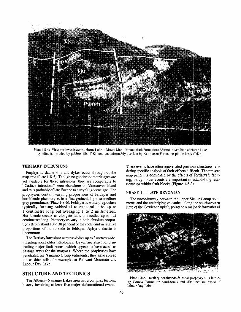
TERTIARY INTRUSIONS
Porphyritic dacite sills and dykes occur throughout the map area (Plate l-8-5). Though no geochronometric ages are yet available for these intrusions, they are comparable to “Catface intrusions” seen elsewhere on Vancouver Island and thus probably of late Eocene to early Oligocene age. The prophyries contain varying proportions of feldspar and hornblende phenocrysts in a fine-grained, light to medium grey groundmass (Plate l-8-6). Feldspar is white plagioclase typically forming subhedral to euhedral laths up to I centimetre long but averaging I to 2 millimetres. Hornblende occurs as elongate laths or needles up to I .5 centimetres long. Phenocrysts vary in both absolute propa- tions (from about 10 to 30 per cent of the rock) and in relative proportions of hornblende to feldspar. Aphyric da& is u”commo”.
The Tertiary intrusions occur as dykes up to 3 metres wide, intruding most older lithologies. Dykes are also found in- truding major fault zones, which appear to have acted as passage ways for the magmas. Where the porphyria have penetrated the Nanaimo Group sediments, they have spread out as thick sills, for example, at Pdtlicant Mountain and Labour Day Lake.
STRUCTUREANDTECTONICS The Albemi-Nanaimc Lakes area has a complex tectonic
history involving at least five major deformation4 events.
These events have often rejuvenated previous structures ren- dering specific analysis of their effects difficult. The present map pattern is dominated by the effects of Tertiary(?) fault- ing, though older events are important in atablishing, rela- tionships within fault blocks (Figure l-8-3).
PHASE 1 - LATE DEVOYIAN
The unconformity between the upper Sicker Group scd- meow and the underlying vo’lcanics, along ,the southwestern limb of the Cowichan uplift, points to a major deformatioral
Plate l-8-5: Tertiary hornblende-feldspar porphyry sills intmd- ing Comox Formation sandslones and siltstones,southwest of Labour Day Lake.
69
event taking place in late Devonian to earliest Mississippian times. Specific effects of this deformation are difficult to document with any certainty in the map area. In the Peak Lake area of McLaughlin Ridge, a fan-shaped array of north- northeast-trending folds with steep to overturned limbs runs contrary to, and appears to be deformed by, later southeast- trending structures. These north-northeast-trending folds may be of Late Devonian age.
PHASE 2 - MIDDLE PERMIAN - PRE-MIDDLE TRIASSIC
All Sicker Group rocks have been affected by a series of southeast-trending, upright to overturned, southwest-verg- ing folds with abundant parasitic minor folds. Major fold axes are often difficult to locate in the field but can be estimated from regional map patterns. Overturning of beds is seen locally in minor folds throughout the area and on the southern limb of a regional anticlinal fold in the Nitinat River area (see Fig l-8-3). The folds are truncated by the overlying Karmutsen Formation (Plate l-8-4).
Penetrative axial planar foliation is generally absent throughout most of the area. However, Sicker Group vol- canics to the west of the Mineral Creek fault and south of the Lacy fault have a well-developed nonh-nonhwest-trending schistosity with generally steep northeasterly dips. Rare chlorite crenulation lineations and elongation of pillows are subhorizontal to shallow dipping.
Faulting accompanied or postdated folding. On McLaughlin Ridge several north to northeast-trending faults crosscut the folds, but are themselves truncated by Tert- ary(?) faults. Their age is unknown but may be pre-Triassic. On the east side of the West Cameron River valley, small- scale faults offset Sicker Group sediments but do not affect the unconformably overlying Kamutsen Formation.
PHASE 3 - LATE TRIASSIC
Extensive crustal dilation accompanied the evolution of Kamwtsen Formation law and intrusions. However, defor- mation specifically associated with this event has not yet been documented within the Albemi area.
PHASE 4 - MIDDLE JURASSIC
Regional-scale warping of Vancouver Island produced the three major geanticlinal uplifts cored by Sicker Group rocks (Figure l-8-1). including the Cowichan uplift. Plutons and stocks of the Middle Jurassic Island intrusions are often elongate parallel to the uplifts, although they apparently show little or no affects of the deformation themselves, suggesting the intrusions were syntectonic to postdefonna- tion. Uplift and erosion followed sometime in the Late Jurassic to Middle Cretaceous, establishing the pre-Nanaimo Group topography.
PHASE 5 -TERTIARY(?)
Large-scale northwesterly trending thrusts cut the map area into several slices (Figure l-8-3). Two major fault zones are recognized. The Cameron River fault tuns southeast along the Cameron River valley, north of Labour Day Lake, past Third Lake and down Dunsmuir Creek to join the Fulton
tault. To the northwest, the fault splits. A northern splay (Qualicum River fault) continues to the west of Home Moun- tain and along the Qualicum River valley, and a southern splay (Lacy fault) runs west near Summit Lake and northwest to Lacy Lake and Esary Lake. The Beaufort fault zone trends southeast along the Beaufort Ranges, passes just east of Bainbridge Lake and Patlicant Mountain and down Rift Creek valley, continuing to the southwest as the Cowichan fault. This fault zone contains several splays.
Where exposed, these thrusts are high-angle reverse faults which dip between 45 and 90 degrees to the east or north- northeast. Slip planes may be relatively sharp and narrow, but wide schistose zones have formed in receptive lithologies and splays and imbricate zones are well developed. The thrusts generally place older rocks over younger and become listric at mid-cmstal depths (Sutherland Brown and Yorath, 1985). Displacements along fault planes are undetermined. Lithological and stratigraphical comparison along the Cam- eron River fault suggests that offsets are probably in the order of 5 to 10 kilometres horizontally and 1 to 2 kilometres vertically. Other faults are not expected to differ markedly from this. Direction of motion is suspected to be westwards: slickensides on fault planes indicate latest movement was horizontal and northwesterly directed.
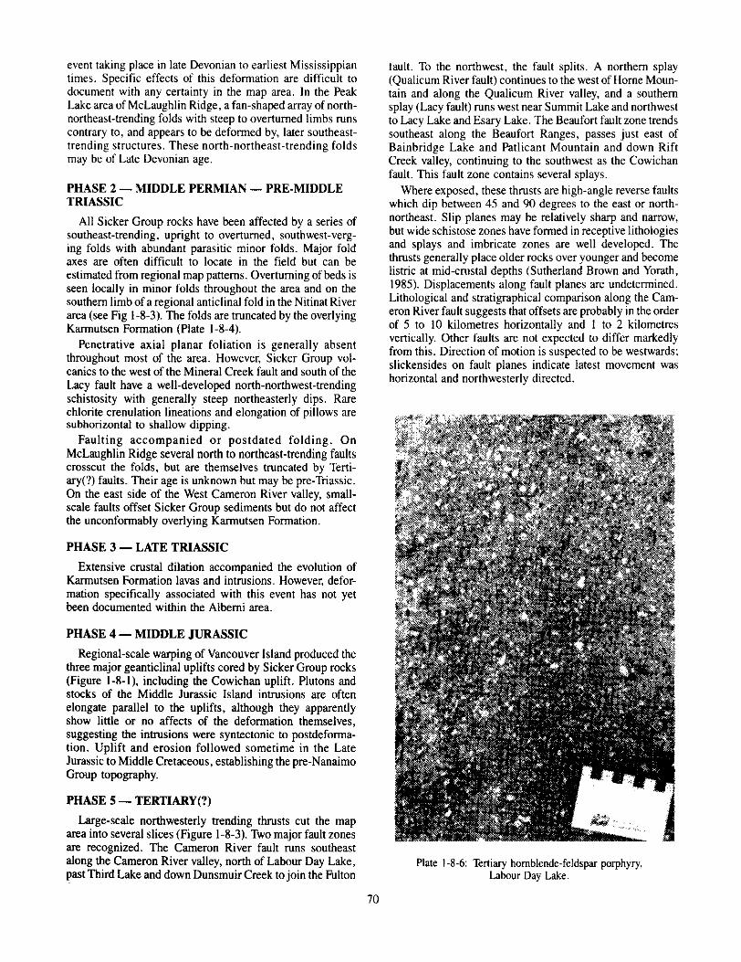
Plate l-8-6: Tertiary hornblende-feldspar porphyry, Lahour Day Lake.
70
The Henry Lake fault connects the Cameron River and Beaufort fault zones, and may have a similar reverse fault geometry although this is speculative at this time. The north- trending Mineral Creek fault offsets the Cameron River and Beaufort faults. It is a subvertical shear zone with apparent sinistral displacements of less than I kilometre. Vertical displacements are undetermined.
The age of faulting is unknown at this time. The faulting involves sediments of the Nanaimo Group as young as the Cedar District Formation. However, the faults are intruded by Tertiary porphyry dykes which show only minor late-stage brittle fracturing. It is suspected that most of the faulting took place during the Tertiary (pre-Oligocene), possibly during crustal shortening accompanying the accretion of the Pacific Rim and Crescent terranes to the south and west ofthe project area.
METAMORPHISM The metamorphic grade in the area is generally quite low,
but increases with the age and structural position of the rocks. Nanaimo Group sediments are essentially unmetamorphosed showing only diagenetic alteration in detrital iron oxides and calcareous cements. Basalts of the Karmutsen Formation show amygdule infillings and veins of chlorite, calcite, epi- dote and quartz, and alteration assemblages typical of the prehnite-pumpellyite facies. Intrusive rocks are unaltered except in chloritic shear zones.
Sediments of the Sicker Group are essentially un- metamorphosed except where involved in intense shearing where chlorite and sericite have developed along foliation planes. Sicker Group volcanic rocks, however, show the effects of greenschist metamorphism. Intermediate to mafic rocks have chloritic schistose matrixes with epidote alteration of feldspars and variable uralitization of pyroxenes. Second- ary quartz, calcite, chlorite and epidote are common in veins and amygdules.
Jurassic granodiorite stocks and plutons in the map area show only sporadic development of contact metamorphic aureoles around their perimeters. The effects of this are most vividly illustrated in the skaming of limestone of the Mount Mark Formation around the Fourth Lake stock. Minor homfelsing of volcanics and sediments is apparent around some smaller stocks, for example in the upper Franklin River valley, and amphibolitization of xenoliths is common.
MINERAL DEPOSITS Exploration and mining in the Albemi-Nanaimo Lakes
area started as early as 1862 with small-scale placer-gold mining on China Creek. Activity increased in the 1890s. principally along Albemi Inlet, China Creek, Mineral Creek and in King Solomon Basin. Several gold veins were staked and modest production was acheived from the Victoria prop- erty. A lull in exploration ensued until the 1930s when prospecting for gold was renewed, resulting in limited pro- duction from the Victoria, Havilah, Thistle, WWW and Black Panther claims (see Table l-8-2). Activity declined again after World War 11. The 1960s witnessed another round
TABLE l-8-2 MINERAL. PRODUCTtON IN THE ALEIERNI AREA
Vicroria ,898, 1934-36 365 9.425 1.679 88 Havilah ,936 & ,939 949 8.056 43.66Y 1.92s 5~751~ Thistle 1938-42 f>.?83 85374 65.969 3OY.088 Black Panther 1947-48. 1YSO ..715 lS.R32 29.642 226 5 S8H www ,899, ,935, I”6 14.650 lSSS2 24 1 1w
1940-41 BDQ ,940 I 62 156 1, Kitchrner ,929 168 124 653 s.366
of exploration, focused on the search for porphyry copper and iron-copper skam deposits, and the regional evaluation of the Esquimalt and Nacaimo Railway Land Grant. No production resulted, howewx The present cycle of expl~~ra- tion followed the discovery of the HW po:lymetallic massive sulphide orebody at Buttle Lake. All areas of Sicker Group outcrop in the Albemi-Nanaimo Lakes area have since t’een staked and numerous exploration targets (defined by milling companies and local prospectors. Extensive drilling has tseen carried out on many properties and Westmin Resources L.im- ited collared a 2.kilometre exploration adit on the Mineral Creek zone in 1988.
Several types of mineral deposit are present in the Albemi~Nanaimo Lakes area.
Volcanogenic, polymetnllic massive rulphides and ex- halative oxides: Polymetallic massive sulphide deposits have been a major target within the Sicker Group since the successful development of the Westmin Resources Limited mine in the Buttle Lake area in the late 1960s. Within the Cowichan uplift, deposits have been found associated with felsic volcanics in the McLaughlin Ridge Formation (for example, Lara, Mount Sicker). However, in the Albemr :xea the McLaughlin Ridge Formation is dominated by mafic to intermeditate volcaniclastic sediments and appears barren of syngenetic mineralization.
Chats, jaspers, manganiferous chats and massive sul- phides of probable exhalative origin are found within the map area, occurring interbeddcd with and werlying pillowed basalts of the Duck Lake Formation. Minor felsic tuffs lmay overlie them. The most important showing so far discovered in this unit is the “900 Zone” on Westmin Resource’s Debbie property. A lean iron formation with a magnetite-rich base 1s locally isoclinally folded with fold axes plunging soah- southeast. Beneath and crosscutting the chat horixxl is a quartz-vein stockwork which may be younger (Tertiary “) in age. Native gold, pyrite, mzlgnetite and arsenopyrite occur in quartz veinlets in the chert and jasper and also in murow carbonate veinlets that crosscut the quartz veinlets. Similar iron amd manganese-rich chats have been prospected in the Summit-Home Lake area, for example, Lacy Lake, and occur at many other localities, for example, upper Cnina Creek and the Butler Peak-Green Mountain area (Moun~aini Jubilee property).
71

15 I Figure l-8-5: Distribution of mineral deposits in the Albemi-Nanaimo Lakes area. I Volcanogenic polymetallic massive sulphides and
exhalative oxides; II Gold-bearing quartz-carbonate veins along shears; III Copper-molybdenum veins and stockworks: IV Other base-metal veins; V Iron-copper skams; VI Epigenetic quartz-arsenic(-antimony) veins: VII Other mineral deposits.
Massive sulphides also OCCUT at this stratigraphic level, although they may have been remobilized during later shear- ing. The major areas of development are on McLaughlin Ridge (Regina, Cop Creek) and in the Nitinat River - Raft Creek area (Kitkat, Raft). Sulphides are also reported in felsic volcanics on the Main/Railway showing north of Stokes. None of these occurrences has yet proven economic.
Gold-bearing pyrite-cbalcopyrite-quartz-carbonate veins along shears: As in the Cowichan Lake and Duncan areas, many of the faults and shears cutting the Albemi- Nanaimo Lakes map area are veined by rusty orange- weathering quartz-carbonate. The more economically impor- tant veins are localized along the Tertiary(?) thrusts and
crossfaults, for example, the Victoria vein on the Mineral Creek fault and the Black Panther vein on the Beaufort fault zone. The quartz veins are variable in strike length and range up to about 1 metre wide. Carbonate alteration zones up to several metres wide border the veins and may extend into the hangingwall and footwall. Mineralization has taken place episodically during motion on the faults, with earlier veins and alteration being disrupted and reveined. Unaltered por- phyry dykes often crosscot veins, suggesting mineralization is pre-Late Tertiary in age. Commonly reported sulphides are pyrite, pynhotite, chalcopyrite and arsenopyrite. Sphalerite and galena are less common. The carbonate is principally ankerite and calcite. Clots of dark green fuchsite or mari- posite OCCUI occasionally with the carbonate. Gold is found
72

both in the discrete quartz veins and in the alteration haloes where it appears to be associated with the sulphides.
Most of the mineral production in the area has been from these quartz-carbonate shear-zone deposits and they are pres- ently the targets of much exploration activity, for example, the Debbie (Mineral Creek zone), Thistle, Black Panther and Lizard Lake properties.
Copper-molybdenum quartz veins and stockworks: Sulphide-bearing quartz veins occur in granodiorite and ad- jacent country rock on several properties in the map area. Most of these are associated with the Corrigan Creek pluton (for example, Andy and WWW), but other showings have been found in the Mount McQuillan stock (Sol and Havilah), the Fourth Lake stock (Surprise and WO 7). the Nanaimo Lakes batholith (Louishman-Maureenah) and the Mount Buttle stock (Allies and Close). Most of the showings are veins but well developed stockwork features are seen on the Andy property and disseminated sulphides on the Starlight. The quartz veins generally contain pyrite or pyrrhotite with chalcopyrite and lesser molybdenite.
Other base-metal veins: Several chalcopyrite-pyrite- quartz vein deposits are hosted in Sicker Group (Rush and Nan), Karmutsen Formation (Lofstrom and Qualicum) or Bonanza Group (Union Jack and MOR) lithologies. Al- though poorly documented, these veins appear to be related to shears but lack the ankeritic alteration associated with the Late Eocene(?) gold-copper veins, and are not obviously related to Jurassic stocks. The PD showing consists of sphalerite-arsenopyrite-bearing veins in Mount Mark Forma- tion limestone. Undoubtedly, several ages and styles of min- eralization arc grouped together here and more documenta- tion is needed to separate them.
Skams: Jurassic Island intrusion granodiorites often pro- duce skams when they intrude limey rocks and skaming may be associated with some of the copper-molybdenum vein deposits (Mary), and with the mined ore at the Thistle mine (Stevenson 1945). Iron-copper skams, similar to those in the Cowichan area (Blue Grouse) are also found in the Albemi- Nanaimo Lakes area. These received scune attention in the past for their copper potential but are now undergoing re- evaluation for gold (Ettlinger and Ray, 1987). The host rocks include limestones from both the Mount Mark Formation (Skam and Tangle 1) and the Quatsino Formation (Kitchen@ as well as limey units within the upper part of the Karmutsen Formation. Sulphides (pyrite, chalcopyrite) and iron oxides (magnetite) occur as irregular pods, lenses and veins within the talc-silicate skam. Gangue minerals include yellow to brown garnet, dark green pyroxene, epidote. calcite, quartz and chlorite.
On the Villalta property, the main exploration target is a stratiform aurifeous hematitic cap developed on the skam. This subhorizontal cap unconformably overlies post-skam karstic collapse breccias, although hematite veins crosscut the skam and hematite also replaces garnet. The cap is overlain by Nanaimo Group conglomerate and may be of middle Cretaceous age.
Epigenetic quartz-arsenic(-antimony) veins: Realgar, stibnite and pyrite are variably developed in Tertiary sills and Haslam Formation argillites on at least two properties (Coal
and Grizzly) in the area. Strong to moderate clay-carbonate alteration and silicification accompany the mineralization and affect the porphyry sills :and the argillites. Mineralization on the Coal claims is probably spatially related to the Mor- iarty fault. These veins, although slightly younger, are pr&a- bly genetically related to the quartz-ankerite shear veins of Group 2 above.
Other deposits: Various nonmetallic deposits have been exploited in the area, particularly Quaternary gravels for aggregate. Marble was quar:ied on the Home Lake property. Subeconomic grades of clay, shale, rhodonite and limestone have been reported from various localities in the area.
ACKNOWLEDGMENTS The authors acknowledge the enthusiastic and capable
assistance provided by Janet Riddell and Sa.ndra Dumais both in the field and the office. Invaluable d:iscussions of the regional geology with Atho~l Sutherland Brown, Christopher Yorath, Timothy England, Stephen Juras and many ott.ers have enriched this project. This season’s fieldwork could not have proceeded without the cooperation of MacMillan- Bloedel Lirnited (Cameron Division) and Crown Forest Lim- ited (Nanaimo Lakes Divi,rion). This manuscript ws im- proved by editorial suggestions of John Newell and Brian Grant.
REFERENCES Armstrong, R.L., Isachsen., C., and Scott. K. (1986): Rb-Sr
and Sr Isotopic Study and U-Pb Dzing of Vancouver Group Igneous Rocks ;and Related Island Intrusions and of the Coast Plutonic Complex and Early Cenoi:oic Igneous Rocks of Vancouver Island, British Columbia, Unpublished Preprint.
Bran~!w, M.T., Orchard, M.J., Parrish, R.R., Sutherland iirown, A., and Yorath, C.J. (1986): Fossil Ages and Isotopic Dates from the Paleozoic ISicker Group and Associated Intrusive Rocks, Vancower Island, British Columbia, in Currem: Research, Part A, Geological Survq of Canada, Fqm 86-IA, pages 683.696.
Clapp, C.H. (1912): Southam Vancouver Ilsland, Geological Surwy of Canada, Memoir 13, 208 pages.
Clapp, C.H. and Cooke, H.C. (1917): Sooke and Duncan Map-areas, Vancouwr Island, Geo@ical Survr;~ c,f Canada, Memoir 96,445 pages.
Ettlinger, A.D. and Ray, G.E. (1987): Gold-enriched Skarn Deposits of British Columbia, B.C. A4inistry of Energy Mine.! and Petrolrum Resources, Geological Fit:ld- work, 1987, Paper 19X8-1, pages 263.279.
Fyles, J.T. (1955): Geology of the Cowichan Lake Area, Vancouver Island, Br:!tish Columbia, B.C. Ministry of Energy, Mines and Petroleum Reso~~rces, Bulletin 37, 79 pages.
Gunning, H.C. (1931): Bllttle Lake Map-area, Vancouver Island, G~olo+zl Surve)~ of Canada, Summary Report 1930, Part A, pages :;6-78.
Jeffrey, W.G. (1967): Buttle Lake, B.C. !dinisrv of Energy, Mines and Perroleun~ Resources, Open File Report, June 21.67.
73

Juras, S. (1987): Geology of the Westmin Resources Myra Falls Mine-area, Vancouver Island, British Columbia, Unpublished Ph.D. Thesis, The Universiry of British Columbia.
Laanela, H. (1966): Mineral Occurrences on E. & N. Land Grant, Vancouver Island, internal company reports for Gunnex Limited, B.C. Ministry of Energy, Mines and Petroleum Resources, Property Files.
Massey, N.W.D. and Friday, S.J. (1987a): Geology of the Cowichan Lake Area, Vancouver Island (92Cil6), B.C. Ministry of Energy, Mines and Petroleum Resources, Geological Fieldwork 1986, Paper 1987.1, pages 223-229.
Massey, N.W.D., Friday, S.J., Tercier P.E. and Rublee V.J. (1987b): Geology of the Cowichan Lake Area, NTS 92Ci16, B.C. Ministry of Energy, Mines and Petroleum Resources, Open File 1987-2.
- (1988~~): Geology of the Chemainus River- Duncan Area, Vancouver Island (92Ci16; 928/13), B.C. Ministry of Energy, Mines and Petroleum Re- sources, Geological Fieldwork 1987, Paper 1988-1, pages 81-91.
Massey, N. W.D., Friday, S.J., Tercier, P.E., and Potter, T.E. (1988b): Geology of the Duncan and Chemainus River Area, NTS 928113 and 92C/l6E, B.C. Ministry of Energy, Mines and Petroleum Resources, Open File 1988.8.
Muller, J.E. (1980): The Paleozoic Sicker Group of Vancou- ver Island, British Columbia, Geological Survey of Canada, Paper 79.30, 23 pages.
Muller, J.E. and Carson, D.J.T. (1969) Geology and Mineral Deposits of Albemi Map Area, Vancouver Island and Gulf Islands, Geological Survey of Canada, Paper 68-50, 52 pages (includes Map 17-1968).
Muller, J.E., and Jeletzky, J.A. (1970): Geology of the Upper Cretaceous Nanaimo Group, Vancouver Island and Gulf Islands, British Columbia, Geological Survey of Can- ada, Paper 69-25, 77 pages.
Stevenson, J.S. (1945): Geology and Ore Deposits of the China Creek Area, Vancouver Island, British Colum- bia, B.C. Ministry of Energy, Mines and Petroleum Resources, Annual Report, 1944, pages 5-26.
Sutherland Brown, A. and Yorath, C.J. (1985): LITHOPROBE Profile Across Southern Vancouver Is- land: Geology and Tectonics, in Field Guides to Geology and Mineral Deposits in the Southern Cana- dian Cordillera, Geological Society of America, Cor- dilleran Section Meeting, Vancouver, B.C., May 1985.
Sutherland Brown, A. and Yorath, C.J. (in preparation): Stmtigraphy, in LITHOPROBE Phase 1, Southern Van- couver Island: Geology and Geophysics, Yorath, C.J. (Editor), Geological Survey of Canada, Bulletin.
Sutherland Brown, A., Yorath, C.J., Anderson, R.G., and Dam, K. (1986): Geological Maps of Southern Vancou- ver Island, LITHOPROBE 1, Geolqical Survey of Canada, Open File 1272, IO sheets.
Yale, R. W. (1963): An Early Permian Fauna from Vancouver Island, British Columbia, Bulletin, Canadian Pe- troleum Geologists, Volume I I, pages 138-149.
~ (1964): A Faunal and Stratigraphic Study of Upper Paleozoic Rocks of Vancouver Island, British Colum- bia, Unpublished Ph.D. Thesis, The University ofBrit- ish Columbia.
~ (1969): Upper F’aleozoic Stratigraphy of Vancou- ver Island, British Columbia, Geological Association of Canada, Proceedings, VoIume 20, pages 30-40.
74