geology and ground-water resources of the. macon …
TRANSCRIPT

GEORGIA
STATE DIVISION OF CONSERVATION
DEPARTMENT OF MINES, MINING AND GEOLOGY
GARLAND PEYTON, Director
19 Hunter Street, Atlanta, Georgia
THE GEOLOGICAL SURVEY Bulletin No. 72
GEOLOGY AND GROUND-WATER RESOURCES OF THE.
MACON AREA, GEORGIA
by
H. E. LeGrand
Prepared by the
United States Geological Survey
in cooperation with
Georgia Department of Mines, Mining, and Geology
ATLANTA
1962

GEORGIA
STATE DIVISION OF CONSERVATION
DEPARTMENT OF MINES, MINING AND GEOLOGY
GARLAND PEYTON, Director
19 Hunter Street, Atlanta, Georgia
THE GEOLOGICAL SURVEY Bulletin No. 72
GEOLOGY AND GROUND-WATER RESOURCES OF THE
MACON AREA, GEORGIA
by
H. E. LeGrand
Prepared by the
United States Geological Survey
in cooperation with
Georgia Department of Mines, Mining, and Geology
ATLANTA
1962

LETTER OF TRANSMITTAL Department of Mines, Mining and Geology
His Excellency, S. Ernest Vandiver Governor of Georgia and Commissioner Ex-Officio State Division of Conservation Atlanta, Georgia
Dear Governor Vandiver:
March 1, 1962
I have the honor to submit herewith Georgia Geological Survey Bulletin No. 72 "Geology and Ground-Water Resources of the Macon Area, Georgia" by H. E. LeGrand of the Ground Water, Water Resources Division, United States Geological Survey.
This is a comprehensive report covering Bibb, Crawford, Houston, Macon, Peach, Schley, and Taylor Counties. The report includes a discussion of the geology and ground-water resources and maps showing geologic and well locations. The maps also show the principal mineral deposits and quarries known in the six-county area. The report is a companion piece to Bulletin 52 and 64 which cover a similar part of the State.
I believe this report is a valuable contribution to the future development of Georgia.
Very respectfully yours,
Garland Peyton Director

CONTENTS
Page
Abstract ________________________ ---------------------------------------------------------------Introduction _____________________ ------------------------------------------- __________________________________ _ Geography ________ _______________________________ ---------------------------------------------------
Drainage ______________________ --------------------------------- -------------------------------------Precipitation _____________________________ ---------------------------------------- _____________ _
Geology ______________ _____ ______________________________ _ ______________________ _
Development of the Coastal Plain province ____________________________________ _ General stratigraphy __________________________________________________________________________ _ Development of soils _______________________________ ---------------------------------------------
1 3 4 5 6 7 7 7 9
Ground-water hydrology _____________________________________________________________________________________ 11 Summary of hydrologic cycle ______________________________________________________ _
Occurrence and movement of ground water ______________ _ Artesian system _________ _ _______________________________ _
Relation of geology and ground water to streamflow __ Chemical character of ground water.. ________________________ _ Use of Ground water__ _ __________________ _
11 11 12 13 16 19
Methods of withdrawing ground water ______________________________ _ -------------------------- 20 Geologic formations and their water-bearing properties __ 21
Pre-Cretaceous rocks _____ ------------------------------------- 21 Cretaceous deposits -------------------------------------------------------- ------------------------- 23 Tuscaloosa formation ___________________________ _ 23 Cusseta sand ______________________________________________ -------------------------------------------------------- 24
Ripley formation_______________________ ______________ 24
Providence sand ____________ -------------------------------------------------------------------------- 24 Ground water in the Cretaceous deposits _ 25 Tertiary deposits_____________________ _ ________________________ _ ------------------------ 27
Midway group__ _ ________________ _ 27 Tuscahoma sand ______________ _ ------------------------------------------------- 27 Tallahatta formation ______________________ _
Gosport sand____________________ --------------------------------------Deposits of late Eocene age ___________ -------------------------------------------------
Residuum ____________________________________ --------------------------------
27 28 29 30
Ground water in deposits of late Eocene age 30 Suwannee limestone ___________________ _ __________________________________________ 31
Surficial deposits______________ ---------------------------- _________________ 33 County descriptions______________________ _ _________________________________________________________ 34 Bibb County_____________________________ ______________ _ ____________________________ 35
Geography ________________ -------------------------------------------------------------- 35 Geology _ ---------------------------------- __ __________________ ___________________ 36 Ground water____ ______________ -------------------------------------------- _____________ 36
Crawford County_________________________________ _ _____ ------------------------------------------ 38
Houston County_____________ ------------------------------------------------------------------- 44 Macon County ____ ------------------------------------------------------------- 51 Peach County___ --------------------------------------------- -------------------------------- 56 Schley County ___ ----------------------------------------------------------- ____________ __________________ 61 Taylor County __________________________________________ ---------------------------- ________________________ 63
Selected bibliography ---------------------------------------------------------------------------------- 68
III

ILLUSTRATIONS
Page
Figure 1. Map of Georgia showing Macon area and areas in previous reports ___ -------------------------------- ___________________________ Pocket
2. Geologic map of the Macon area, Georgia ___________________________ Pocket
3. Diagram showing generalized surface and subsurface features in the eastern half of the Macon area _ 8
4. Diagram showing the common occurrence of a stream cutting through a water-table aquifer and into the uppermost artesian aquifer__ ______________ ___ __________ _______ 15
5. Columnar sketch of formations in the Macon area 22
6. Map showing wells and location of ground-water sup-plies in the Macon area, Georgia _________ Pocket
TABLES
Page
Table 1. Chemical analyses of ground water, Macon area, Georgia 18
2. Use of ground water in Macon area, 1959 _ _ 22
3. Records of wells in Bibb County______ _ ___ 39, 40
4. Records of wells in Crawford County______ _ _________ _43
5. Records of wells in Houston County ________________________________ _49, 50
6. Records of wells in Macon County ___ _ _ ____ 57, 58
7. Records of wells in Peach County ------------- - 60
8. Records of wells in Schley County _ _ _______ 64
9. Records of wells in Taylor County __ ------------------------ _______________ 67
IV

GEOLOGY AND GROUND-WATER RESOURCES OF THE MACON AREA, GEORGIA
By H. E. LeGrand
ABSTRACT
This report concerns the geology and ground-water resources of an area of 2,055 square miles in central Georgia, including Bibb, Crawford, Houston, Macon, Peach, Schley, and Taylor Counties. The seven-county area, conveniently called the Macon area for the largest city, is within the Coastal Plain province.
Relatively unconsolidated strata of Late Cretaceous to Recent age slope gently to the southeast. The overall structure in the Coastal Plain is relatively simple. Underlying the sedimentary formations are igneous and metamorphic rocks, which crop out in the northern part of the area and which extend northward through much of north-central Georgia to form the Piedmont province.
Several formations of Cretaceous age are present, but they are less distinctive than in the adjacent Chattahoochee Valley on the west. The Tuscaloosa formation is the oldest sedimentary formation exposed on the Coastal Plain. Above it, in ascending order, are the Ripley and Providence formations, also of Late Cretaceous age. The Tuscaloosa and Providence formations are composed of poorly bedded and massive deposits of sand and light-colored clay, the sand and clay occurring separately and also mingled to varying degrees. The Ripley contains much sand in the northern, or updip, part of its outcrop area, but, in its typical development, it is composed of dark-colored bedded clay. The Blufftown and Eutaw formations have been identified between the Tuscaloosa and Ripley formations from wells in the southern part of the Macon area, but these formations cannot be mapped in the Cretaceous outcrop belt.
Deposits of Tertiary age, which overlie the Cretaceous, crop out in the southern part of the area. These deposits attain no great thickness although they thicken appreciably toward the southeast. Of the Tertiary sediments, those of late Eocene age, including the Ocala limestone, residuum derived from solution of it, and the contemporaneous Barnwell formation, are the most
'~ widespread. Toward the east, these late Eocene deposits overlap

2 GEORGIA GEOLOGICAL SURVEY BULLETIN 72
much of the Cretaceous, thereby narrowing the Cretaceous outcrop area.
The preponderance of sand in the Cretaceous beds and the relatively high permeability of these sands, which permit the ready percolation of a large part of about 45 inches of precipitation each year into the underground reservoir, results in exceedingly large potential yields from wells deriving water from Cretaceous beds. Although few wells have tested the available supply, many wells can be expected to yield more than 800 gpm (gallons per minute), both in the outcrop area and downdip to the south under cover of younger sediments. A perennially dependable yield of several million gallons of water a day is available for withdrawal from each square mile throughout most of the Coastal Plain.
The deposits of Tertiary age furnish adequate water for domestic supplies, but no effort has been made to develop larger supplies from them because large supplies are available from underlying Cretaceous deposits. Valleys, which cut through the thin Tertiary deposits, allow considerable diffuse leakage of water, in consequence of which potential yields from them are not generally great.

INTRODUCTION
The area described in this report, for convenience called the Macon area, includes seven counties lying in the drainage basins of the Ocmulgee and Flint Rivers along the inner margin of the Coastal Plain in Georgia. These counties are Bibb, Crawford, Houston, Macon, Peach, Schley, and Taylor (fig. 1).
An investigation of the geology and ground-water resources of the area was begun in April 1948 and was continued intermittently until February 1949. Some additional field work was done in February 1960. Records of wells were obtained in all the towns and in most of the rural areas.
This investigation precedes any large development of ground water in the area and represents a preliminary hydrologic study in that no large-scale tests have been made to determine the quantity of water that can be withdrawn from the aquifers. The geology of the area was mapped in order to study qualitatively the ground-water conditions, as each formation possesses some degree of individuality both geologically and hydrologically.
This study is a part of a continuing ground-water investigation being made in cooperation with the Georgia Department of Mines, Mining and Geology by the U.S. Geological Survey.
The information obtained from well drillers has been valuable in the understanding of the ground-water conditions of the area, and it is with their help that this report is possible. S. M. Herrick, of the U. S. Geological Survey, supplied several stratigraphic well logs and other unpublished subsurface information. Captain Garland Peyton, Director, Georgia Department of Mines, Mining and Geology, gave helpful suggestions and assistance in the preparation of the report.

GEOGRAPHY The area described in this report lies along the inner margin
of the Coastal Plain. The northern part of Bibb, Crawford, and Taylor Counties is in the Piedmont province. Separating the Piedmont from the Coastal Plain is an arbitrary line generally known as the Fall Line, along which, in some States, streams descend in a zone of falls from rather resistant crystalline rocks of the Piedmont to less resistant rocks of the Coastal Plain. In the area studied, no falls occur along the streams in this zone, but the term Fall Line may be retained to delimit the two provinces generally.
The Piedmont province is an upland area of moderate relief, the highest parts of which rise to about 800 feet above sea level in the area studied. The land slopes gently to the south, and the major drainage is southward. Locally the tributary streams are closely spaced and fan out in random style. In the interstream area, the gently rolling terrane is mantled by thick soils of moderate fertility.
South of the Piedmont province, deposits of Cretaceous age crop out in an east-west belt (fig. 2), producing a distinctive type of topography and referred to as the Sand Hills. The area is mantled by loose, incoherent sand and is very hilly; the lightcolored sandy hills rise to nearly 800 feet in western Taylor County. Streams are more widely spaced in the Piedmont and have cut valleys as deep as 300 feet below the upland. Deep, precipitous gullies are actively encroaching upon the upland areas, where sand is removed at the gully heads by rainwash and deposited in the gully bottoms as subaerial deltas (Veatch and Stephenson, 1911, p. 30) or "sand streams." The sand of the undisturbed Cretaceous deposits and the "sand streams" are so permeable that runoff from precipitation is slight. Rain may move the sandy material downslope a short way, but the downward percolation of water limits its erosive power. Parts of the interstream areas have not yet been attacked by advancing gullies and stand fully as high as the hills of the Piedmont farther north. Moisture is not readily retained in the infertile sandy soils, resulting in a sparser cover of vegetation than is generally found in the southeastern States.
The Fort Valley Plateau represents the outcrop area of Eocene deposits. The plateau forms a belt south of the Sand Hills and is characterized by deep-red clayey soil and flat topography which is only slightly dissected. It is typically displayed in Peach County near Fort Valley. The plateau appears to be a

GEOLOGY AND GROUND-WATER RESOURCES-MACON AREA, GA. 5
plain of solution, beneath the surface of which ground water has dissolved a layer of preexisting limestone. A few shallow depressions on the plateau are evidence of the solution action. The flatness of the area has helped to retard leaching of the soil, and crops tend to grow better than on the leached soils of the Sand Hills area farther north. The Fort Valley Plateau is the peach-growing center of the State, the northern limit of peach orchards representing the northern limit of the plateau.
An upland area in the southern part of Houston County is separated from the lower lying Fort Valley Plateau by a northfacing escarpment. This upland is similar to the Tifton Upland, which covers much of the Coastal Plain southward. The upland has not been subjected to solution subsidence as has been the Fort Valley Plateau, and the difference in altitude of these two subprovinces of the Coastal Plain approximates the thickness of limestone removed by solution near the base of the scarp.
Drainage
The Macon area lies within the drainage basins of the Ocmulgee and Flint Rivers, which flow in more or less parallel courses southward in consequence of the regional slope. Both rivers rise in the Piedmont Plateau near Atlanta.
The Ocmulgee River flows southward through eastern Bibb County and forms the eastern boundary of Houston County. The streams flowing into the Ocmulgee have prevailing southeast courses and include Tobesofkee, Echeconnee, and Big Indian Creeks. These creeks rise very close to the Flint River and appear to have pushed the divide between the Flint and Ocmulgee westward. Almost all small tributaries flow southward to join the larger creeks at an acute angle. The flood plain of the Ocmulgee is generally about 2 miles wide.
Flint River separates Crawford from Taylor County and flows southward through Macon County. Like the Ocmulgee, Flint River has no large tributaries from the east. The larger tributaries, all flowing southeastward to join the Flint, are Patsiliga, Whitewater, and Buck Creeks. The water of these tributaries is clear because of the purity of sands over which it flows. The scarcity of streams from the east has minimized erosion to the extent that a pronounced west-facing escarpment is close to the river; on the east side of the river north of Montezuma the flood plain is either narrow or nonexisting.

6 GEORGIA GEOLOGICAL SURVEY BULLETIN 72
Precipitation
The climate of the Macon area is characteristically humid and temperate. The annual precipitation, which at Macon averages 44.60 inches, is adequate for the growth of many varieties of crops. The precipitation is almost all rainfall and is fairly well distributed throughout the year. The lowest rainfall is generally during September, October, and November, but rarely does any month receive less than 2 inches.

..
GEOLOGY Development of the Coastal Plain Province
The Coastal Plain of the area studied is a part of a large coastal province extending from Long Island, N. Y., to the Mexican border and southward to Guatemala. Its development has resulted from the interdependence of three great natural processes - differential earth movement, erosion, and sedimentation. At the beginning of Cretaceous time, and for a long time previously, southern and eastern Georgia was a land area of igneous and metamorphic rocks, like those of the Piedmont providence, and of consolidated sedimentary rocks of Paleozoic age, like those of northwestern Georgia. Soon the margin of the continent was depressed, allowing the sea to encroach on the land. Since this advance in Cretaceous time, the sea has retreated and advanced to varying positions many times. As it came close to the present Piedmont province, the sea became a resting place for material eroded from the land area. Rocks of the Piedmont disintegrated and decayed into soil and rock fragments, which were washed by rain into streams and carried to the sea. Much of the Cretaceous sediments were deposited on lowland margins of the plain before reaching the sea. Some of these nonmarine deposits were eroded and redeposited in the sea, but some were buried and preserved by the deposits of an advancing sea. In addition to clay and sand that was eroded from the land area and deposited, some marl and limestone were formed as the result of the precipitation of chemical matter from the sea water and the settling of dead marine organisms. Whether deposited in the sea or along marginal land areas, the sediments tend to be preserved in nearly flat, but gently coastward-dipping layers (fig. 3).
General Stratigraphy
The stratigraphy was studied in order to understand the occurrence and movement of ground water. The rock materials are conventionally grouped into formations according to their lithology. A formation is named after a place where it is typically exposed. For example, the Providence sand was named for Providence Canyons in Stewart County. A formation may be only a few feet thick or many hundreds of feet thick, and it may be composed almost entirely of clay, sand, or limestone. Most formations contain a variety of beds, but some feature is commonly present to distinguish it from the overlying and un-

8 GEORGIA GEOLOGICAL SURVEY BULLETIN 72
Figure 3.- Diagram showing generalized surface and subsurface features in the eastern half. of the Macon area. (Tertiary materials are chiefly limestone, with lesser amounts of sand and cloy; Cretaceous
materials ore sand and cloy).
derlying formations. As a result of changes in conditions of deposition, all formations change in character along the beds. A common change is a gradual transition from a bed composed chiefly of sand to one composed chiefly of clay.
At varying distances from a place where a formation is typically exposed, the character of its material changes to such an extent that its name and its description are no longer appropriate. Thus, different names may be applied to rock materials that were deposited at the same time at different places. For example, several distinctive Cretaceous formations occur in the Chattahoochee Valley of western Georgia where they were de-

GEOLOGY AND GROUND-WATER RESOURCES-MACON AREA, GA. 9
posited under marine conditions. Eastward, some of these formations contain nonmarine beds, and in the area studied, difficulty was experienced in tracing them (Eargle, 1955, p. 1).
Development of Soils
Different kinds of soil occur in the Coastal Plain province, and their development has been controlled by geologic conditions. Insofar as such development is concerned, the deposits may be classified by four categories. These include (1) slopes and hills on outcropping Cretaceous formations, (2) broad flat uplands on outcropping Tertiary formations, (3) slopes extending from the flat uplands to valleys, and ( 4) flat alluvial soils of lowland areas.
In the Sand Hills area, characterizing the Cretaceous outcrop belt, loose surface sand is widespread. This is underlain at many places by a zone of sand with interstitial clay, which in turn is underlain by its parent Cretaceous clay or clayey sand. The writer considers these three zones as representing the A, B, and C horizons of the normal soil profile. The zones are so distinctive in character and color that some geologists tend to regard them as separate geologic formations. It appears to the writer that clay originally present in the surface zone has been carried down by per percolation water into the B horizon, where a pink or red hardpan has developed. Some of the surface sand has been transported by wind, an action that may have been prominent during some dry climatic period of the Pleistocene epoch. These soils are so well drained and coarse textured that they have low fertility.
The soils of the broad, relatively flat areas of Tertiary formations vary in color from light gray to deep red. The surface soils are predominantly sand, but they are not leached as much as the surface soils of the Sand Hills area. Either clayey subsoil or parent material lies within a few feet of the surface in most places, resulting in moderately well drained soils suitable for growing crops.
The slopes extending from the relatively flat uplands to the streams cut across beds of clay and sand. As erosion is fairly active on these slopes, the soil profile rarely gets a chance to develop to maturity. In some places the parent materials are exposed, and in many places surface material from upland areas has migrated toward the valleys and now mantles the parent

10 GEORGIA GEOLOGICAL SURVEY BULLETIN 72
material. Soils on these slopes vary greatly in character and are not easily classified.
The major streams are bordered by flat areas, or flood plains, which are underlain by clay, sand, and gravel. As the flood plains lie only a few feet above normal stream level, their soils are subject to overflow and to the deposition of "new" soil material. The soils vary from moderately well drain€d to poorly drained, but they contain more organic matter than other soils of the area. Natural vegetation is abundant on these lowland soils.

GROUND-WATER HYDROLOGY Summary of Hydrologic Cycle
The precipitation that reaches the ground in the Macon area takes diverse courses. Much of it infiltrates the sandy surface, but some flows overland immediately after each rain into rivers and creeks. Some precipitation immediately evaporates, whereas some seeps into the soil only to be evaporated later or transpired by vegetation. If the rain is prolonged, some water passes downward below the root zone, but some of this water is thwarted in its vertical movement by clay beds and is shunted laterally above the water table to a surface slope where it is evaporated; the remaining water continues downward to the water table, which is the top of the zone of saturation, in which all the open spaces in the sand, clay, and limestone beds are filled with water. Upon reaching the water table, its progress is retarded, but it still moves by gravity to some low place where it discharges from the ground. Ground water discharges in low areas as seeps and springs and as evapotranspiration (direct evaporation and transpiration by vegetation).
Occurrence and Movement of Ground Water
Almost all the materials of the Coastal Plain in the area studied are loose and unconsolidated. Thus, the quantity of water that can be stored underground between the mineral grains is great. The sand and clay, which represent the bulk of the materials, differ in their ability to store and transmit water. Clay has a high percentage of pore space, but the openings are so small that water tends to be retained against the pull of gravity. In contrast, sand may have less pore space than an equivalent volume of clay, but the openings are larger and allow a quicker movement of water.
All the southward-thickening wedge of sediments is saturated with water except for a layer of air-filled materials a few feet or a few tens of feet thick lying between the ground surface and the water table. The change in storage of ground water is reflected in the change in position of the water table. The depth to the water table depends on the frequency, duration, and intensity of the precipitation. The position of the water table depends also on the topography and on the ability of the sediments to transmit water. The water table beneath the upland areas is higher than the stream valleys. This results in a hydraulic gradient toward the valleys, where ground water dis-

12 GEORGIA GEOLOGICAL SURVEY BULLETIN 72
charges into streams and swampy areas. In areas of relatively flat topography underlain by poorly permeable materials such as clay, sandy clay, or fine sand, the water table is within a few feet of the land surface. The continuous movement of ground water into stream valleys results in a tendency toward a continually declining water table. However, periods of precipitation are rather numerous and fairly evenly distributed throughout the year; during and immediately after the period~ of precipitation, the amount of water entering the ground-water reservoir exceeds the amount moving out into the valleys, and the water table rises.
Artesian System
The Coastal Plain formations are ideally disposed for the occurrence of artesian water. Contrary to popular belief artesian water does not, at every place, come from great depths; some artesian water in the counties studied occurs at depths of less than 50 feet below the land surface.
To understand artesian conditions in the area, it is necessary to understand the relation between the profiles of the water table, the land surface, and the geologic formations. The water table is present throughout the Coastal Plain, lying in sand in some places and in clay or limestone in others. Both the beds and the land surface are inclined toward the southeast, but the inclination of the beds is steeper. As the water table is roughly parallel to the regional land surface, the number of clay and sand beds beneath the water table increases toward the southeast. The clay beds are relatively impermeable and tend to confine water under pressure that lies beneath them. The water enters the ground, reaches the water table, and flows " * * * down with the slope of the water table to a point where the zone of saturation is interrupted by an impermeable bed. Part of the water may pass above the bed and continue to flow under water-table conditions, and part of it flows beneath the bed. Now it is confined, pressing upward against the impermeable bed with a head equivalent to the difference in elevation between that point and the elevation of the water table in the area of recharge, less the loss of head resulting from friction in movement. This is confined or artesian water; it will rise in a tightly cased well to a height above the bottom of the confining bed equivalent to the pressure head at that point. If the head happens to be above the land surface, as it commonly

GEOLOGY AND GROUND-WATER RESOURCES-MACON AREA, GA. 13
is in the valleys or along the coast * * * , the well will flow" (McGuinness, 1951, p. 12-13).
Beds composed of coarse to medium sand are the most permeable in the area; these beds, which allow water to pass through them readily, are referred to as aquifers. The least permeable beds are composed of clay. Limestone, which occurs in the southeast corner of the area, contains some permeable beds, and southward beyond the area studied it is an aquifer of great importance. The interlayering of sand and clay results in a composite artesian system consisting of several artesian sand aquifers and intervening clay confining beds. Some geologic formations tend to be composed chiefly of sand, others of clay, and others of limestone. Yet, graduations of materials are common, and some formations contain several aquifers and confining beds. The coastward homoclinal slope of the beds results in a specific artesian aquifer becoming more deeply buried toward the coast; the number of artesian aquifers below a specific place also is greater coastward. To some extent each artesian aquifer acts as a pipe or conduit to transmit water from a place of recharge at a high elevation to a place of discharge at a low elevation. The analogy may be useful in the area studied, but it tends to break down if the entire coastward part of the artesian system is considered, because water at great depth can discharge only by slow upward movement through relatively impermeable beds.
Relation of Geology and Ground Water to Streamflow
In referring to the earth materials as an underground reservoir, it must be borne in mind that the water underground is in temporary or transient storage because it is moving slowly toward an outlet. It tends to move through permeable sand and around the relatively impermeable clay, following courses of least resistance from points of high elevation to points of low elevation. However, some water moves through seemingly impermeable clay, and there is some interchange of water between aquifers throughout the Coastal Plain system. Where the water table is higher than the pressure surface of the uppermost artesian aquifer, as in much of the interstream area, water tends to move downward from the water-table aquifer to the artesian aquifer even through beds of clay. In most of the stream valleys the relations are reversed, and water from the

14 GEORGIA GEOLOGICAL SURVEY BULLETIN 72
uppermost artesian aquifer tends to leak upward into the watertable aquifer or into the stream.
The erosive power of streams has resulted in their channels being lowered as much as 50 to 150 feet below the upland interstream areas. Thus, the water-table aquifer and the uppermost artesian aquifer are incised, and much water "bleeds," or discharges from them. Ground water discharges as evapotranspiration, springs, and seepage into the stream channels (fig. 4). Both the water-table aquifer and the uppermost artesian aquifer lose water to the stream.
All the rivers and larger creeks in the Macon area cut into both the water-table aquifer and the uppermost artesian aquifer, which are thus a good source of water for the streams in dry weather. It seems likely that the uppermost ground water -that within about 100 feet of the land surface - moves relatively rapidly; ground water near some streams may move as much as several tens of feet per day. However, beneath the broad interstream areas the movement is slower. The deeplying artesian water in the southern part of the area may move no faster than a few feet or a few tens of feet a year.
Whitewater Creek, in the Sand Hills of Taylor County, has a remarkably high and stable flow (Carter and Lendo, in LeGrand and Furcron, 1956, p. 129). This creek drains an area of loose Cretaceous sand where infiltration of precipitation is great and evapotranspiration and surface runoff after storms are slight. It has an average flow of 950,000 gpd (gallons per day) per square mile, and a minimum flow of 770,000 gpd per square mile that is expected only 1 day in every 20 years (Thomson and others, 1956, p. 154).

Discharge area
(evapotranspiration, springs, and channel seepage)
Permeable sand
Water table
Figure 4.- Diagram showing the common occurrence of a stream cutting through a water- table aquifer and into the uppermost artesian aquifer. The stream and valley vegetation gain water from both aquifers.

CHEMICAL QUALITY OF GROUND WATER
Most of the sediments were deposited in an environment of sea water or brackish water. The original mineralized water has been flushed from the formations by natural movement from precipitation through the beds to areas of discharge. All natural water in contact with earth materials contains some mineral matter in solution. Water tends to have a great amount of dissolved mineral content if the length of time and distance the water moves through the ground are considerable and if relatively soluble materials are present in the formations.
Some specifications that have been adopted by the American Water Works Association and by some municipalities as a standard for public water supplies are given in the following table. The specifications are not rigid because greater concentrations are tolerated by some users, but much lower concentrations would be preferred.
Iron and manganese, together _____________ less than 0.3 ppm Magnesi urn ___________________________________________ less than 125 ppm Chloride __________________________________________________ less than 250 ppm Sulfate --------------------------------------------------- _less than 250 ppm Fluoride ___________________________________________________ less than 1.5 ppm Total solids _____________________________________________ Jess than 500 ppm
Although hardness occurs in objectionable quantities in only a few places in the area, it is a subject of considerable importance. Hardness in water is recognized in the home by the difficulty in getting a lather without using an excessive amount of soap and by the sticky curd that develops after using soap. Hardness affects many manufacturing processes, and it causes scale deposits to form in hot-water pipes and steam boilers. Water having a hardness of less than 60 ppm is considered soft and is suitable for most uses. Where the hardness is between 61 and 120 ppm, the water is considered moderately hard and may be satisfactory for many uses, but not in high-pressure boilers or in some industrial processes. Water containing more than 120 ppm is considered hard.
Hardness of water is the property attributable to the presence of alkaline earths, and results from the solution of calcium and magnesium salts from the soil and rocks (limestone and dolomite). Water that contains carbon dioxide readily dissolves carbonate minerals ; in the presence of carbon dioxide the carbonates are converted to more soluble carbonates.

GEOLOGY AND GROUND-WATER RESOURCES-MACON AREA, GA. 17
A noteworthy feature of the ground water in the area is the extremely low dissolved-solids content. (See table 1.) Water in the formations of Cretaceous age passes through relatively insoluble sand and clay, and in most places contains less than 75 ppm total dissolved solids. The water is extremely soft, exceeding 30 ppm total hardness only in a few places. Even the deep artesian water in the Cretaceous formations, which tends to move slowly, retains its low mineral content. The limestone formations, which occur in southern Houston County, yield water that is moderately hard.
Iron occurs in objectionable amounts in ground water of much of the area. As little as 0.3 ppm tends to stain porcelain and laundry. In some places ground water contains objectionable amounts of iron in solution, whereas in a few places the water contains no iron. However, iron may be dissolved from the iron pipes because of corrosive action of the water. A distinction between the two ways in which iron may develop is very important, because the methods of treatment are not necessarily the same. The corrosive potential of a water is indicated by the pH. The pH value, in simple terms, is a number denoting the degree of acidity or alkalinity and is useful in evaluating the chemical character of water. A pH of 7.0 is considered neutral, which means that the water is neither acid nor alkaline. Values of pH greater than 7.0 denote increasing alkalinity, and those less than 7.0 denote increasing acidity. Almost all water in the sandy formations of the area has a pH of 7.0, or less. Thus, the prevailing acid water tends to dissolve iron from pipes with which it comes in contact, and on exposure to air the iron is precipitated as a reddish stain.
Another striking feature of the ground water is its low chloride content. Water with a chloride content of 500 ppm may have a discernible taste to some people. (Sea water has a chloride content of slightly more than 19,000 ppm.) Throughout the Atlantic and Gulf Coastal Plain the deep water is salty, and some deep-lying beds in midsections of the Coastal Plain contain salty water. No wells have yet penetrated salty water in the study area. Only along the southern border of Houston County at a depth greater than 1,200 feet is it likely that salty water will be found.

Well No.
22 24 38 39
4 17 29
3 18 24
15 24 35
I 18 32
County
TABLE 1.-CHEMICAL ANALYSES OF GROUND WATER, MACON AREA
(Constituents in parts per million)
Date of
collection
Waterbearing material
Analyst!
Parts per million
bii 6
8 ~ 8 "0 ~ ~ 8 g ~ ?3. ~ d .: ; 8 __...._ ~ - tll ll) ] ~ _..-..,
- ~ ~ rn 8 ::1~ 0_.--., ""d ""d .....- ~0 .@ ~ ·§ ~ .:-~+ ~g ~ '§ ·g ~~ "EU aJ ~ 8 ~ ~8.~ ~~ ~ 8 ~ ~~ d3~ ~
------1-----1-----1-----------~---------------------- ------__ _ 2-28-56 Sand Betz 9 0 . . . . . 4 0 2 0 . . . . . -~- . . . 8 0 2 0 . . . . 6 6 0 Bibb
do. do. do.
5-24-48 do. Turner 10 0 7 . . . . . . . . . . . . . . . 15 . . . . . . 4 G 25 23 6 8 5-13-41 do. Law 6 0 I . . . . . . . . . . . . . . . . . . . I 3 0 . . . . . 23 5 6 0 4-14-41 do. do. 6 0 2 . . . . . . . . . . . . . . . . . . . . I 0 2 0 27 42 6 7
-C-r-aw_f_o_r_d--I--1-0--25-48--I--G-r-a-ni-te--I-T-ur-n-er---l--38 ___ -----:Q2 -1-1 - -15--~~--37- _li)_5 ___ 0_ ---135"" _8_9_ ~ do. 5-24-48 Sand do. 6. 0 . 35 . . . . . . . . . . . . . . . 28 4. 0 37 35 7. 5
___ d_o_. ---+-6_-_3o_-4_8_+ __ do_. __ + __ do_. ___ ~ __________ · _· i_· _· _· ._. ___ 9 ____ ~- _____ 6_5 ______ _
Houston 5-IS-53 do. WR 7.0 .05 1.0 .5 3 5 .9 2.0 0.0 19 4 5.4 do. 10-25-48 do. Turner 16 .9 6.0 7.0 21 2.0 44 37 6.5
__ d_o_. ___ 1 ___ 4-_29_-_59 __
1 ___ d_o. ___
1 __ w_R ____
1 __ w ____ 1_._o ___ 1_._2 ___ ._9_ ~- __ o_ -~ ~~~ _2_5 ___ 6 __ 4_._4_
Macon do. do.
Peach do. do.
5-29-47 do. Turner 7.0 4.0 14 1.5 25 15 3.7 12-17-42 do. do. 24 .6 7.2 3.0 9.0 5.0 86 34 4-29-59 do. WR 42 .4 14 2.0 50 5.0 4.0 110 43
+~~~i ~~: ~iner u- J: ... ::: ...... ::~- ::~-r--:--- ... 2::~ ---~-:-~ i~ T ---:::----~3--~~--s-.-h!-.y-- --5--1-0--46- ___ d_o __ ---I--W-R ___ -~-1- .--------:64-10-- --~.-o- 2.4~---22- -~-2-- _2 ___ 5_ --.-~- __ 5_1 __ 2_9_ ~=
14 do. 5-2S-59 do. WR 12 .2 16 1.7 2.5 38 16 3.5 .2 74 47 6.4 --13-- --T-ay-1-or-- --5--2-9·--5-9--l--d-o-.-- WR 6. 8 --:o5 --1.-2-~---.2-~--.-8- --4-,--_-4-U- --.-0---26 --4-~-
1Turner, Georgia Department of Mines, Mining, and Geology; WR, Quality of Water Branch, U.S. Geological Survey; others are private companies.
...... 00

USE OF GROUND WATER
All the municipalities of the Macon area use water from wells except Macon, which treats water from the Ocmulgee River. The towns of Warner Robins and Fort Valley use between 1 and 2 mgd (million gallons per day). Montezuma, Perry, and Bntler use slightly less than 1 mgd, and other towns use less amc:;::ts. Industrial use is not great, although several industries, a iew miles south of Macon, in Bibb County, pump a total of 3 or 4 mgd. Warner Robins Air Base now (1960) uses about 1.5 mgd. Locally irrigation with well water is practiced but the overall use is small. Spraying peach trees during parts of the year is an important rural use of ground water. Table 2 shows the ground water used in the Macon area in 1959.
A feature of the use of ground water in the area is that no significant cone of depression has developed in the water table or artesian-pressure surface, not even at Warner Robins or in the area south of Macon. In both these areas, natural groundwater discharge by evapotranspiration and seepage into streams is great. An increase in pumping will result in a decrease in the natural discharge; thus, much of the apparent waste of water by natural discharge can be salvaged, and pumping levels may not be lowered appreciably by increased withdrawal. The potential supply of water from wells in these areas, as well as in almost all other areas of the Coastal Plain, is considerable.
Table 2.-Use of ground water in Macon area, 1959
Use of water Total water pumped mgd
Municipal ____________________________________________ 9. 9 Rural __________________________________________________ 5.8 Industrial ________________________________________ 2.4 Irrigation ____________________________________________ . 62
mgy
3,614 2,117
876 61.8

METHODS OF WITHDRAWING GROUND WATER
In the days of the early settlers, springs were a major source of water. Springs are still common in low ground near streams, and they furnish water extremely low in dissolved mineral matter. The excellent character of almost all water from springs in the area is due to the rather rapid circulation at shallow depths through sandy deposits. Nearly all of the springs yield less than 10 gpm (gallons per minute), and in fact, most yield 1 or 2 gpm. Since springs emerge from coves or reentrant, near the bottom of a hill, they are not readily accessible to most water users, who tend to live on upland areas.
Dug wells 20 to 70 feet deep were common sources of water during past generations, but these wells have decreased in number within recent years.
Drilled wells are increasing in number and are used throughout the area. Wells penetrating igneous and metamorphic rocks in the northern part of the area are cased to the top of hard rock to depths ranging from a few feet to 100 feet; the hole is open in the rock, and water enters the well from fracture-type openings in the rock.
Almost all the drilled wells of the Coastal Plain draw water from beds of sand. Many wells no larger than 3 inches in diameter have an open end which allows sand to flow into the well. Excessive pumping causes these wells to fill with sand and thus to decline in yield. Other wells have a screen or strainer at the bottom, the screen holding back the sand that otherwise would come into the well. Almost all municipal and many industrial wells are of the multiple-screen type. These wells are furnished with several screens that are placed opposite the beds of sand. Many of the multiple-screen wells have gravel inserted as an envelope around them so that the pore space around the wells will be large enough to allow water to move into the wells readily; these are referred to as gravel-walled or gravelpacked wells. Multiple-screen wells for which the sizes of the screens are properly selected, and in which the screens are carefully set opposite the beds of sand, yield the maximum amount of water.

GEOLOGIC FORMATIONS AND THEIR WATER-BEARING PROPERTIES
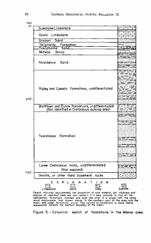
The areal distribution of the formations underlying the Coastal Plain of the Macon area is shown on the geologic map (fig. 2) and their stratigraphic sequence is illustrated in figure 5. A description of the geologic features and water-bearing properties of these formations follows.
Pre-Cretaceous Rocks
Igneous and metamorphic rocks of Paleozoic and older age lie beneath the sedimentary materials of the Coastal Plain and are exposed in the extreme northern part of the area studied. These so-called crystalline rocks were not separately mapped and were not studied in detail. Many of them are granitic, being (1) true granite, (2) biotite-granite gneiss, or (3) a granite component in a diorite injection complex. Slate and altered volcanic rocks occur in at least one northeast-trending belt. All these rocks are highly weathered and where exposed are generally soft and friable.
As only a few drilled wells in the Macon area derive water from the igneous and metamorphic rocks, few data are available from which to determine the water-bearing properties of these rocks. However, although some wells yield as much as 100 gpm and others as little as 1 gpm, information derived from a study of similar rocks in other parts of Georgia indicates that they yield only small supplies of water. The average expected yield does not greatly exceed 20 gpm.
22 GEORGIA GEOLOGICAL SURVEY BULLETIN 72
Feet
o·-~~~-Suwannee Lime stone
Ocala Limestone
Gos art Sand
875'-
1750'-
Tallahatta Formation Tuscahoma Sand Midway Group
Providence Sand
Ripley and Cusseta Formations, undifferentiated
Blufftown and Eutaw Formations, undifferentiated (Not identified in Cretaceous outcrop area)
Tuscaloosa Formation
Lower Cretaceous rocks, undifferentiated (Not exposed)
Granite, or other hard basement rocks
E X p L A N A T I 0 N
£5! 0 ~ Limestone Sand Clay
Figure 5.-Columnar sketch of formations in the Macon area.

CRETACEOUS DEPOSITS Tuscaloosa Formation
The Tuscaloosa formation is the oldest outcropping formation of the Coastal Plain of Georgia. It extends into Georgia from the vicinity of Tuscaloosa, Ala., where it is typically exposed (Cooke, 1943, p. 8). It crops out as an irregular band, generally less than 15 miles wide, bordering the Piedmont province.
The south boundary of the Tuscaloosa, where it is in contact with a younger overlying formation, is not precisely distinguishable in the area studied. This is due to the lithologic similarity of Cretaceous formations in their updip areas. Considerable difficulty was experienced in mapping the Cretaceous deposits in Taylor County, where only the area north of the Central of Georgia Railroad is known with certainty to be underlain by the Tuscaloosa formation. Of the area mapped as undifferentiated Cretaceous, the stratigraphically lowest part is of Tuscaloosa age. Study of stratigraphic relations in the area indicates that the Tuscaloosa is not overlapped by younger deposits but crops out continuously across the area.
The Tuscaloosa formation consists of light-colored sand, sandy clay, and lenticular masses of clay. It is not well bedded and no individual beds have been traced far. The beds do not indicate regular or cyclic deposition, and hence the basal part of the formation may be lithologically similar to the top. The Tuscaloosa thickens southward, and where it is covered by younger material it may be as much as 600 feet thick.
The Tuscaloosa formation in its outcrop area lies on crystalline rocks of Paleozoic and older age. It is possible that deposits of early Cretaceous age underlie the Tuscaloosa in Southern Houston County. The Cusseta sand of late Cretaceous age overlies the Tuscaloosa in southern Taylor County. Southward, beds of the Blufftown and Eutaw formations tend to be wedged between the Cusseta and Tuscaloosa. Eargle (1955, p. 23-31) mapped the Eutaw and Blufftown formations in Taylor County, but the writer does not believe that they can be distinguished from the overlying and underlying formations. It is possible that younger Cretaceous deposits, either the Ripley or the Providence formation, overlie the Tuscaloosa in Peach County and on the uplands in central Taylor County. As far as could be determined, the Tuscaloosa is overlain by the Providence sand in Houston County.

24 GEORGIA GEOLOGICAL SURVEY BULLETIN 72
Cusseta Sand
The Cusetta sand was named by Veatch (1909, p. 82-90) from the town of Cusseta in Chattahoochee County. It is not distinguishable from the Tuscaloosa, which underlies it, or from the updip part of the Ripley, which overlies it in the outcrop area. Therefore, it has not been mapped separately but is included in the undifferentiated deposits of Cretaceous age. The Cusseta is composed chiefly of loose yellow sand, although clay beds are common in the upper part. In fact, the deposits of Cusseta grade upward into interlaminated yellow clay and fine sand of the Ripley formation with which it is apparently conformable. Although the Cusseta is about 110 feet thick at Perry, Houston County, it is probably not represented in the Cretaceous outcrop areas of Houston and Bibb Counties.
Ripley Formation
The Ripley formation is exposed in the deeper stream valleys of Schley County and in a few places in Taylor and Macon Counties. It is not definitely known east of the divide between the Flint and Ocmulgee Rivers, although beds in stratigraphic position corresponding to the Ripley crop out in northern Peach County. Although distinctive in Schley County, it cannot be separated from other Cretaceous formations in parts of Taylor, Crawford, and Peach Counties, and consequently may occur in the stratigraphically high parts of the area mapped as undifferentiated Cretaceous.
In its outcrop area, the Ripley probably does not exceed 80 feet in thickness, and downdip under cover it does not thicken as much as other Cretaceous formations. Where erosion has exposed the Ripley in valleys in Schley and Macon Counties, it is composed of dark-gray clay interlaminated with lesser amounts of fine sand. After long exposure, the color becomes lighter, and outcrops in Taylor County are light yellow or white In outcrops in Taylor County, the Ripley is sandy. Massive white kaolin m Taylor County may be a part of the Ripley formation.
Providence Sand
The Providence sand was named by Veatch (1909, p. 86) from the settlement of Providence in Stewart County. It is the youngest and uppermost Cretaceous formation in Georgia and con-

GEOLOGY AND GROUND-WATER RESOURCEs-MACON AREA, GA. 25
sequently forms the southernmost part of the Cretaceous belt in the area studied. It is well exposed west of the Flint River in northern Schley and Macon Counties, and it also caps some of the hills in Taylor County. It has been mapped eastward through Peach and Houston Counties to the Ocmulgee River. The Providence lies on the Ripley formation except in southern Bibb and northern Houston Counties, where it overlaps the Ripley to rest on the Tuscaloosa formation.
The dip at the top of the Providence formation, as estimated from outcrops and a study of wells in Schley County, is slightly less than 15 feet per mile. If this dip is projected northward, it is apparent that the ridge at Mauk, in Taylor County, is underlain by the Providence.
The Providence is less than 120 feet thick in its outcrop area, although it thickens under cover of other sediments southward. It consists of light-colored sand and masses of white clay. In lithology it is similar to the Tuscaloosa, with which it is in contact in northern Houston County. Except in Taylor County its deposits are strikingly different from the dark-colored bedded clay and sand of the underlying Ripley formation.
Ground Water in the Cretaceous Formations
In the Macon area the deposits of Cretaceous age furnish adequate water supplies to present users and are capable of yielding enormous supplies to future developers. Water is derived from beds of sands which characterize all the Cretaceous formations except the Ripley. The water contains little mineral matter because of the comparative insolubility of the minerals through which it passes.
The surface of the Cretaceous deposits in their outcrop areas is generally mantled by loose sandy soil containing very little interstitial clay. This sandy surface, despite its irregularities, permits rain water to percolate downward into the ground rather than to run off. Thus, of about 45 inches of precipitation on the area yearly, practically all goes directly into the ground. The Cretaceous deposits are capable of temporarily retaining much of this water before it drains laterally into the stream valleys. If the pumping of ground water increases, the amount of drainage into the valleys will decrease. Therefore, in the outcrop area most of the precipitation is available for development, in addition to water already in storage in the ground.

26 GEORGIA GEOLOGICAL SURVEY BULLETIN 72
South of and downdip from the outcrop area, the water-bearing beds of sand are covered by impermeable clay, and the water is under artesian pressure. The beds of sand are lenticular and consequently cannot be traced easily. However, as several beds of sand may be penetrated in a well at least 300 feet deep, the discontinuity of beds at a particular horizon does not impair the development of ground water.
The beds near the base of the Cretaceous deposits dip more than 35 feet per mile toward the south and southeast, and those at the top dip a little more than 15 feet per mile in the same direction. Inasmuch as the overall slope of the land surface is slightly less than 15 feet per mile to the southeast, the Cretaceous deposits become buried at a progressively greater depth in that direction. They lie within 150 feet of the surface except beneath the upland in Houston County, where as much as 250 feet of Tertiary sediments overlie them.
The Cretaceous deposits have yielded as much as 1,000 gpm to several individual wells without drawing the water level down more than 40 feet. Where large amounts of water are required, it may be advantageous to place screens at the level of two or more sand beds. The practice of placing two or more screens in a well, especially for municipal or industrial use, results in a composite water level of all aquifers used and does not represent that of an individual aquifer.

TERTIARY DEPOSITS Midway Group
Deposits of the Midway Group of Paleocene age overlie tb~ Providence formation. The area of outcrop narrows eastward and is completely overlapped near Perry, in Houston County. The Midway does not have a broad continuous outcrop but instead occupies long narrow bands in the valleys of the southern parts of Schley, Macon, and Peach Counties and small outliers north of Buck Creek in Macon County.
The Midway Group, as mapped, consists of one or more thin beds of white sandy fossiliferous limestone of the Clayton formation and bedded dark-brown clay. The beds are less than 75 feet thick in the outcrop area. Stephenson and Veatch (1915, p. 69) estimate its thickness along the Flint River to be 300 to 400 feet, but this thickness doubtless includes deposits of Eocene age. Owen (1959, p. 48) refers to bauxite in kaolinitic clay of the Midway Group in Sumter County, which lies south of Schley County. Bauxite appears to have developed on the uppermost weathered parts of the dark-colored clay of the Midway Group in both Sumter and Schley Counties.
The limestone beds in the Midway Group are too thin to be aquifers in the Macon area. The beds of clay in the subsurface are everywhere in the area south of their outcrop area, and their relatively low permeability almost prevents any transfer of water between the underlying Cretaceous aquifers and the overlying Tertiary aquifers. So far as is known, no drilled well in the Macon area derives water entirely from the Midway Group.
Tuscahoma Sand
Beds equivalent in age to the Tuscahoma sand of Alabama (Toulmin and others, 1951, p. 62-65) occur in southern Schley County, according to Herrick (personal communication). The formation, of early Eocene age, consists of dark-colored glauconitic silt and silty glauconitic sand. It probably does not exceed 25 feet in thickness and is exposed only in stream valleys near the Sumter County line. Owing to its low permeability, its local occurrence, and its thinness, the Tuscahoma sand is not considered important hydrologically.
Tallahatta Formation
In the early part of the field work, the writer did not recognize the Tallahatta formation. The work by Owen (1959, p. 48)

28 GEORGIA GEOLOGICAL SURVEY BULLETIN 72
in Sumter County pointed out that sands of the Tallahatta formation extended northward into Schley and Macon Counties. The writer mapped sand deposits between the Tuscahoma and the red clayey deposits of late Eocene age, but he assumed that they were part of the Gosport sand of middle Eocene age. It now appears that the Tallahatta underlies the Gosport sand in the southern parts of Schley and Macon Counties. These two formations are not easily separated. The Tallahatta contains interlaminated sand and clay, the sand being somewhat coarser than that of the overlying Gosport. The Tallahatta formation has a maximum thickness of about 50 feet.
Gosport Sand
On the geologic map of the Tertiary and Quaternary formations of Georgia, MacNeil (1947) shows deposits of middle Eocene age overlying the Wilcox Group and older formations. So far as is known, the Gosport sand represents the only middle Eocene deposit in the Macon area.
The Gosport sand consists of fine- to medium-grained sand and little or no interstitial clay. It contains some of the cleanest sand in Georgia. In southern Schley and Macon Counties, the Gosport contains some calcareous sand, and farther south in adjacent Sumter and Dooly Counties the equivalent of the Gosport is a marl or limestone.
Although the Gosport has a wide belt of outcrop, good exposures are limited to thin bands on hill slopes below late Eocene deposits that cap the hills in the Gosport outcrop area. Sands of the Gosport occur in Schley, Macon, Peach, and Houston Counties. The formation is generally less than 60 feet thick but appears to be much thinner, owing to the masking of its upper part by the slumping of the overlying deposits. Red sandy clay of late Eocene age on upland slopes drapes over much of the Gosport, concealing the white sand except in steep, recently formed road cuts.
Considerable water enters the Gosport sand. However, the fact that the Gosport occupies the interstream areas and is cut into or through by valleys means that water can leak out along the valley sides in much of the area. So much leakage occurs that in Peach County and in the northern part of Houston County the Gosport is referred to by well drillers as the "dry sand." The leakage, for the most part, is not localized to

GEOLOGY AND GROUND-WATER RESOURCES-MACON AREA, GA. 29
the extent of forming numerous springs but is disseminated so that most of the water is lost through evaporation and transpiration.
South of the area of leakage, the Gosport furnishes adequate water supplies to domestic drilled wells. The slight dip causes the Gosport to be at or near the surface. Consequently, it is the uppermost aquifer in its outcrop area and southward. Water in the Gosport is under water-table conditions except in the southern parts of Houston, Macon, and Schley Counties, where slight artesian pressures may exist. The maximum expected yield from a well tapping the Gosport sand is not known, but it may be as much as 140 gpm. The loose, incoherent sand requires the use of well screens. Many of the small screens are replaced within 10 years because the water corrodes them. Except for the slight acidity of the water, it is of good quality, being exceedingly low in dissolved solids.
Deposits of late Eocene age
Two formations, the Barnwell formation and the Ocala limestone, are equivalent to the Jackson Group of the Gulf Coast.
Bright red sand composes most of the Barnwell formation, but some limestone and clay beds also are present. The clay consists of one or more beds of green or dark-gray clay. It is typically exposed in Twiggs County, adjacent to Bibb County on the southeast, and has been described as the Twiggs clay member of the Barnwell formation (LaMoreaux, 1946, p. 19). Interbedded with the clay are marl, calcareous clay, and limestone. The Twiggs clay member, including the nonclay beds, in most places is less than 60 feet thick. Southward, the proportion of clay decreases.
The Ocala limestone occurs in southern and eastern Houston County. Also, an outlier of Ocala limestone lies on Cretaceous deposits about 5 miles southeast of Roberta in Crawford County. It is more than 20 miles (Cooke, 1943, p. 72) updip and north of any exposure of the Ocala. The separation of this outlier from the main body of Ocala is due chiefly to its unique position between widely spaced streams; thus, it has been preserved from the somewhat ravaging erosion of stream valleys. The presence of Ocala limestone at Rich Hill, in Crawford County, is evidence that deposits of late Eocene age once extended farther north and that the veneer of red clay on the

30 GEORGIA GEOLOGICAL SURVEY BULLETIN 72
Fort Valley plateau, lying in the stratigraphic plane, is a residuum of the Ocala. The presence of the Ocala at Rich Hill also indicates the magnitude of the overlap of deposits of late Eocene age. These deposits extend over sediments of older Tertiary and Cretaceous age and once rested on the crystalline rocks. The dip at the base of the Ocala is about 15 feet per mile to the southeast.
According to Cooke (1943, p. 75), the Cooper marl overlies the Ocala limestone with apparent conformity. As it occurs only in southeastern Houston County and has no significance in the study of ground water it will not be discussed further. The Cooper is distinctive from the Ocala in its faunal content rather than in lithology.
Residuum.-On the geologic map of the Tertiary and Quaternary formations of Georgia (MacNeil, 1947), large areas of residuum are shown. This residuum is an insoluble residue of former limestone beds, chiefly the Ocala limestone in the Macon area. It forms the Fort Valley Plateau, which is a flat upland plain of solution. In much of the area mapped as residuum, solution has removed all readily soluble material from the limestone. The residuum, for the most part, is a deep-red sandy clay, occurring on the interstream areas and draping downslope over the underlying Gosport sand. Its downdip limit is generally marked by a northwest-facing escarpment. This escrapment, a part of which is visible south of Big Indian Creek in Houston County, gives a fair measure of the role of subsidence in solution of this limestone. To some extent, limestone beds of the Midway group and some beds of Oligocene age have been removed by solution, but they are not included in the residuum of this report. It is difficult to distinguish between the residuum and the Barnwell formation; the scarcity of distinctive beds and the red color suggest that much of the Barnwell formation of eastern Georgia is a residuum of thin limestone beds.
Ground Water in Deposits of late Eocene Age
Although the Ocala limestone is the most important artesian aquifer of the Coastal Plain in Georgia, it does not extend northward far enough to be important in the Macon area. Only those drilled wells on the upland in southern Houston County derive water from the Ocala. The water levels are more than

GEOLOGY AND GROUND-WATER RESOURCES--MACON AREA, GA. 31
100 feet below the land surface and the aquifer is under watertable conditions in Houston County.
The sands of the Barnwell formation and those of the residuum yield some water to dug wells, but their elevated interstream positions, which favor leakage of water, and their thinness prevent them from being important aquifers.
The largest source of water for the recharge of artesian aquifers on the Coastal Plain is the outcrop area of the particular aquifer. This is essentially true of the Ocala limestone, but several qualifying comments are in order. The outcrop area of the Ocala is difficult to delimit. The residuum of Ocala west of the Flint River and north of Big Indian Creek is not in contact with the limestone aquifer. Thus, the true outcrop area of Ocala limestone lies in a small area south of a line connecting Montezuma and Perry but not including the upland in southern Houston County where the Suwannee limestone crops out. Even in its restricted outcrop area the limestone is mantled by rather impermeable residual clay, which might retard the recharge of water to the limestone. Therefore, it appears that the outcrop area of the Ocala in the Macon area does not appreciably recharge the artesian component of the Ocala farther southward. The blanket of relatively impermeable clay of the Midway Group should prevent upward leakage of water from the underlying Cretaceous deposits and thus prevent recharge to the limestone in this manner. The above statements suggest that the recharge facilities are poor. However, they appear to be adequate for maintaining the natural artesian pressure in the limestone farther south.
Suwannee Limestone
The Suwannee limestone of Oligocene age is an extensive formation in the southeastern part of the Coastal Plain of Georgia, but in the area studied its main body is restricted to the upland south of Big Indian Creek, in Houston County. The residuum in Houston and southeastern Macon Counties probably includes some material that is part of the Suwannee. No good exposures of the Suwannee were found, the limestone being mantled by thick residual soil and boulders of flint. The thickness of the Suwannee limestone does not greatly exceed 50 feet.
The localized area and thinness of the Suwannee prevent it from being an important aquifer in the Macon area. It contains

32 GEORGIA GEOLOGICAL SURVEY BULLETIN 72
sufficient water for domestic drilled wells, however. The water in the Suwannee limestone is under water-table conditions, and it is perched about 100 feet above the water table in the underlying Ocala limestone. These two water tables are separated by the relatively impermeable Twiggs clay member, which prevents water from the Suwannee leaking downward into the Ocala. South of Houston County, perhaps in Pulaski County, the intervening Twiggs is absent, and the Suwannee and Ocala limestones becomes a hydrologic unit having only one water table.

SURFICIAL DEPOSITS
Deposits classified as surficial include (1) the unsorted gravel and sandy clay of probable Pliocene age overlying the Cretaceous and Tertiary deposits of the Coastal Plain over parts of the interstream areas and (2) Quaternary alluvial deposits bordering the major streams.
Unsorted gravel is a matrix of red sandy clay forms a thin cap on parts of the upland area in northern and eastern Taylor County. These deposits have been dissected by erosion to such an extent that only in some interstream areas are they still preserved. Even so, they have migrated downslope, and their true areal extent is arbitrarily delimited. These deposits range in altitlde from more than 700 to less than 350 feet. They generally occur west of the Flint River and slope toward it, which suggests that they may have been flood-plain deposits of the Flint River before it incised its valley to its present level.
The major streams flow through alluvium deposited by them at a relatively recent stage. The belt of alluvium bordering the Flint and Ocmulgee Rivers is wider west of the rivers than east.
The surficial deposits at high elevations yield little ground water because of their thinness and because of the great leakage of water from them to lower slopes. Little is known about the alluvial deposits bordering the streams, but in some places they are believed to be thick and permeable enough to furnish very large supplies of water to wells.

COUNTY DESCRIPTIONS
In the following pages, the geography, geology, and groundwater conditions in each county are described briefly. Tables of representative wells and chemical analysis of water samples are given. Some wells listed furnish domestic supplies, but information about the yield of each well is not available because the amount of water actually needed for home use is small and may be only a fraction of the potential yield of the well.
The wells for which data were collected are numbered consecutively by counties; the numbers in the well tables and the chemical-analyses table correspond to the well numbers in figure 6, and in the text of the report.

GEOLOGY AND GROUND-WATER RESOURCES-MACON AREA, GA. 35
BIBB COUNTY Area: 251 square miles. Population: 139,999"
Geography
Bibb County forms the northeast corner of the area of this report. Macon, the county seat and only municipality, as well as the largest city of the area studied, has a population of 68,860. It is an important manufacturing, railroad, and agricultural exchange point for the central part of Georgia. The county is well served by rail, and the highway and community roads are good. The kaolin deposits of Georgia extend into the county, and considerable kaolin is mined from the Cretaceous deposits east of Ocmulgee River along the Twiggs County line. Some sand is recovered from the Tuscaloosa formation south of Macon. Excellent road material for secondary roads is taken from disintegrated granite about 10 miles west of Macon.
The Piedmont Plateau occupies the northern half of the county. The topography is rolling to hilly; the main streams, having adjusted their courses to the structure of the underlying crystalline rocks, flow eastward to join the through-flowing Ocmulgee River, which receives the entire drainage of the county. Owing to the variety of rocks underlying the Piedmont, the soils differ from place to place, but in general they are deep red and reasonably fertile.
The Sand Hills represent the outcrop area of the Tuscaloosa formation and occupy the Coastal Plain part of the county. This part of the county comprises a series of rolling divides between the large creeks, the creeks flowing in east-west courses to the Ocmulgee River. The rather flat upland between Tobesofkee and Echeconnee Creeks may be due to less erratic but more thorough stripping of overlying deposits elsewhere. The upland east of the Ocmulgee River is higher than that west of the river. The Ocmulgee River in deepening its channel has left patches and wide expanses of alluvium as river-cut terraces on both sides. The business section of Macon is built on a terrace about 75 feet above the river.
"Population figures cited for all counties and the city of Macon are preliminary figures for 1960 from the U. S. Bureau of the Census. Figures for the cities of Fort Valley, Montezuma, and Perry are from the 1959 population estimates of the Georgia Department of Public Health. All other population figures are from the 1950 Census Bureau records.

36 GEORGIA GEOLOGICAL SURVEY BULLETIN 72
Geology
The Tuscaloosa formation occupies the southern two-thirds of the county, forming a southward-thickening wedge of sediments. The Tuscaloosa is composed of fine to coarse sand, in places mingled with white kaolin and in others separated by lenticular and rather pure kaloin masses. The base of the Tuscaloosa dips slightly east of the south at approximately 30 feet per mile, its contact with the underlying crystalline rocks being 141 feet below sea level, or 500 feet below the land surface, at Cochran field in the southern part of the county.
East of Ocmulgee River, outlying bodies of late Eocene age occur along the interstream area. These deposits consist of (1) the Barnwell formation which is composed of massive deep-red, clayey sand, (2) one or more beds of green or gray fullers-earthtype clay, and (3) beds of limestone having only spotty outcrops. The limestone beds are limited to the area adjacent to Twiggs County on the southeast. The red sands of the Barnwell formation on the interstream areas have slumped and crept downslope so as to drape over the Tuscaloosa formation in many places. This draping has been so prevalent that it is not unusual to see a contact between the Barnwell and the underlying Tuscaloosa at one point on a slope and to see what appears to be the same contact at a considerably higher point on the same slope, the higher point being the true contact and the lower one being a false or "drape" contact. Beds of sand capping the low-lying upland south of Tobesofkee Creek near U. S. Highway 41 may be a part of the Barnwell formation, although they have not been so mapped. They appear too low stratigraphically to be Barnwell. Inasmuch as these beds are less than 25 feet thick in most places and are present only locally, they have been placed in the Tuscaloosa.
Alluvial deposits bordering the Ocmulgee River and some parts of the larger creeks are the youngest sediments in the county. They are of Pleistocene and Recent age. These deposits are composed of unsorted clay, sand, and gravel, which in most places are less than 40 feet thick and extend 1 or 2 miles on each side of the river.
Ground Water
Dug wells furnish practically all water used in the northern part of Bibb County underlain by crystalline rocks. Generally

GEOLOGY AND GROUND-WATER RESOURCEs--MACON AREA, GA. 37
they are about 30 inches in diameter, 20 to 60 feet deep, and yield approximately 1 to 15 gpm from the weathered material above bedrock.
Where the Tuscaloosa formation extends south of U. S. Highway 80 and west of Ocmulgee River, water supplies from drilled wells can be obtained readily. The number of sand beds increases southward, resulting in an increase in the availability of water to wells southward. The Tuscaloosa furnishes water to all drilled wells on the Coastal Plain of Bibb County except in the immediate area around Macon where sands of the Tuscaloosa may be too thin. Some domestic drilled wells are only 2 inches in diameter and less than 70 feet deep, these wells satisfying local requirements of only a few gallons of water per minute.
Development of ground water during World War II at Cochran Flying Field in the southern part of the county has produced considerable information concerning the depth of the Tuscaloosa and its water-bearing sands and the yield of water from them. In well 39 the sands above the 220-foot level were screened at the following intervals: 106-121, 126-146, 17 4-179, and 210-220. When the static water level in the well was 64 feet in 1942, about 550 gpm was pumped and the water level was drawn down about 35 feet.
During World War II, efforts to develop a ground-water supply at Camp Wheeler, about 6 miles east of Macon, were apparently successful, although this potential supply was not fully utilized. Here, well 12 was drilled through 333 feet of sediments of the Tuscaloosa before ending on bedrock. Several screens were set opposite the better sands, which resulted in a yield of 535 gpm and a drawdown of 45 feet.
The water in the two wells just cited was under only slight artesian head, owing to the small difference between the elevation of the aquifers at the well and that at the intake area a few miles farther north. Flowing wells with slight artesian head may be realized from the Tuscaloosa in the lowland areas south of Macon.
The deposits of Eocene age are too thin to furnish water to drilled wells, and they have no water-bearing significance in Bibb County. Alluvial deposits along the Ocmulgee River should furnish water to industrial wells where these deposits are of sufficient thickness. The alluvium probably is similar in water-

38 GEORGIA GEOLOGICAL SURVEY BULLETIN 72
yielding properties to the Tuscaloosa formation, which underlies it south of Macon.
A record of wells inventoried in Bibb County during the investigation is shown in table 3.
CRAWFORD COUNTY Area: 313 square miles. Population: 5,796
Geography
Crawford County is almost entirely rural. Roberta, with a population of 673, is the only town, although Knoxville, an adjacent settlement, is the county seat. Agriculture is the chief occupation and peaches and cotton are important crops. Much uncultivated land is suitable for the growth of timber. Kaolin is abundant in the Tuscaloosa formation, the major prospects having been described by Smith (1929, p. 74-91). Limestone of the Ocala formation has been quarried at Rich Hill, 5 miles east-southeast of Roberta.
The northern half of Crawford County lies in the Piedmont province, the southern half in the Coastal Plain. The Piedmont, for the most part, is very hilly, owing to the headward growth of many small streams on the upland. Some land lies at an altitude of about 600 feet, especially along the divide which Georgia Highway 7 follows. This divide separates the drainage basin of the Flint River on the west from that of the Ocmulgee River on the east.
The Coastal Plain extends northward to the vicinity of Roberta, at which place its feather edge has been made irregular by erosion by south-flowing streams; thus, peninsulas of the Tuscaloosa formation lie on the crystalline rocks of the Piedmont, producing a different outcrop pattern from that of other counties along the Fall Line in which outliers are common. The Sand Hills, representing the outcrop area of Cretaceous deposits, form most of the southern half of the county. The topography is hilly, owing to the fact that both the Flint River on the west border and Echeconnee Creek on the east border have channels considerably lower than the general upland. The erosion by tributaries of these two streams has left a divide trending southeastward from Roberta; the divide rises to more than 700 feet above sea level at Rich Hill. The surface soil zone in the

TABLE 3.-RECORDS OF WELLS IN BIBB COUNTY -·
i ~ ' Type ~---- I 0 ~ Water-bearing unit I
I
-"r-; ...co=:--:-
I ~~~~ J.ocation Owner of ~~ Sci ""'""''fi.l-P (sand unless specified Topography
~ well <:<;!~ g.~~ otherwise) ~-----~ A ~~
-----------1 8 miles NW. of Macon Southern Natural Gas Co. Open end 600 8 25 Granite (rock) ! Slope 2 do do do 593 8 24 do .. do
671 3 do do do 600 8 do 41 do 4 7 miles NW. of Macon Stewart-McE!reath
Lumber Co. do 61 6 .. .... do 36 Valley 5 8 miles W. of Macon Curtis Watson do 52 3 Granite and diorite (rock) 38 Slope 6 5 miles E. of Macon McAfee Candy Co. Screened 245 10 .. ... Cretaceous (undifferentiated) 30 Flat plain
I Macon 7 Dempsey Hotel Open end 235 10 50 Granite (rock) 35 Terrace 8 do Proctor & Gamble Screened 60 7ft. 60 Cretacecus (undifferentiated) 21 do 9 3 miles S. of Macon McAfee Candy Co. do 114 6 .. ... do 35 do
10 do do Open end 560 6 Granite (rock) 45 Flat plain II do Atlantic Ice Co. Screened 60 6 .... Cretaceous (undifferentiated) . .. de 12 4 miles E. of Macon U.S. Army (Camp Wheeler) do 239 1C do 28 do 13 5 miles SE. of Macon B. E. Willingham do 200 4 .. do Flood plain 14 do do do I 185 6 ... do do 15 do do do 200 8 ... ... do de
16 4 miles S. of Macon Strietmann Biscuit Co. Gravel- 303 8 200 do ... ... Slope packed
17 de U.S. Navy Ordnance Plant Screened 287 8 287 do 53 do 18 do Macon Kraft Co. Gravel- 282 8 282 do 48 do
packed
19 10 miles SW. of Macon Bethel Church Open end 38 2).-:i 38 do 25 do 20 do J. Singleton do 88 2 do 73 Upland 21 4 miles S. of Macon Armstrong Cork Co. Gravel- 280 8 243 do Slope
packed
do do do 22 do 243 8 243 ..... do 23 do do do 285 8 285 do 42 do 24 5 miles S. of Macon Peach State Lodge Screened 103 2 .... do 50 Upland 25 10 miles SW. of Macon Lee Honeycutt do 44 2 ..
I
do 22 Slope 26 do J. Sowells do 144 2).-:i ... do . ... do 27 do Clint Jones do 69 2).-:i ... do 55 do 28 10 miles SW. of Macon Henry Gentry do 127 2).-:i .... :I do
I 107 Upland
29 do Zeke Stokes do 40 2).-:i .... do 18 Upland plain 30 do E. L. Tanner do 179 2).-:i
...... 1 do 125 do
31 8 miles S. of Macon W. J. Bryant do 90 2).-:i ...... do 55 do 32 do L. 0. Stokes do 63 2).-:i do i 56 do
I
I I
I
I
Hemarks
Yield , 100 gpm. Yield , 78 gpm. Yield affe<·ted by
mping of well I. pu Yield , 46 gpm; drawdown 100 ft.
Well furnishes 10,000 gpd.
. s;;~~ 200
ns set at 100-110, 178-188, -220, 232-242 ft. Yields, 40 gpm. 1,1 , 150 gpm. Well not used. r used for cooling. T. 70°F.
Yield Wate Yield, Yield Yield,
25 gpm . , 5 gpm. Well abandoned.
325 gpm . Yield, Flows Flows
535 gJ:m; drawdown 45 ft. 30 gpm. T. 66°F. 50 gpm. T. 66°F.
Flows 8 ft. above ground into mming pool. Flows 300 gpm.
448 gpm; drawdown 94ft. swi
Yield,
Yield, 400 gpm. Scree
163 ns set at 123-128, 147-152, -168, & 182-187ft. Yield, gpm. 340
. s~~~~ ns at 117-125, 145-155, 195-, & 255-260 ft. Yield, 430
m. 200 gp
Yield, Yield,
.. . ...
. ...
.....
...
200 gJ:m. See analysis. 635 gpm; drawdown 80ft.

0 z
Location
~ 33 do 34 9 miles S. of Macon 35 do 36 10 miles S. of Macon 37 do 38 do
39 do
40 13 miles S. of Macon 41 do
TABLE 3.-RECORDS OF WELLS IN BIBB COUNTY-CONTINUED
id Type -"'~ Owner of
well ~~ ~:.::..
Cl ~ ---------
Standard Oil Co. do 191 6 W. W. Herndon do 95 2 Grady Wilcoxon Screened 75 2Y, George Avant do 75 2 Dewey Skippers do 75 2Y, Cochran Flying School Gravel- 373 10
packed I I
do do 225 1 10 I
H. G. Hamlin do 861 J. D. Bradley do 105
~ I o.., _,o-..... -....; ~~~
C<Q
Water-bearing unit (sand unless specified
otherwise)
--142 do
do do do do
373 do
225 do
do do
'-<~--:-
~.;~ i:i:
70 38 6C 50 60 95
64
45 51
Topography
Slope do
Upland plain do do de
do
do do
Remarks
Screens at 142-147 & 157-162 ft.
Yield 620 gp;,;· .dra,;,d~;.:n 60ft. Screens at 105-110, 132-147, 224-
234, 314-319, & 353-368 ft. See analysis.
Yield 550 gpm; drawdown 35ft. See analysis.

GEOLOGY AND GROUND-WATER RESOURCES-MACON AREA, GA. 41
Sand Hills is generally so sandy that crops do not thrive in it. The Fort Valley Plateau, underlain by Eocene deposits, forms
the upland area in the extreme southeastern part of the county. In comparison with the hilly terrain of the adjacent Sand Hills, this area is very flat and locally is poorly drained. The soil is relatively rich.
Geology
Of the Cretaceous deposits in Crawford County, the Tusaloosa formation is by far the most extensive, its outcrop covering most of the area south of the Fall Line. It consists chiefly of white coarse sand, sand mingled with kaolin, and lenses of kaolin. It thickens from less than 50 feet at Roberta to perhaps more than 300 feet in the southern part of the county. No record is available of any well having been drilled through the Tuscaloosa to the crystalline rocks south of the Roberta area. The Ripley formation barely extends into the southern part of the county. It consists of yellow laminated sand and clay beds, white sand, and some kaolin. Owing to the lithologic similarity between it and other Cretaceous formations in updip areas, its contact is not definite. The Providence sand overlies the Ripley formation, but as its updip beds barely enter the southeastern part of the county, it is probably less than 70 feet thick. Outcrops are limited to a few valley slopes.
Of the Eocene deposits, the Gosport sand lies under the residuum in the southern part of the county, but its extreme thinness and the draping effect of the overlying residuum generally prevents its exposure. The residuum also is relatively thin. It is a veneer of red sandy clay, in few places more than 50 feet thick, which forms the Fort Valley Plateau. The Ocala limestone farther north at Rich Hill, equivalent in age to the residuum, is a small outlier more than 660 feet above sea level. Rich Hill is a noted geologic locality consisting of soft white fossiliferous limestone more than 20 miles updip from the main body of Ocala. Some dense gray clay, similar to the Twiggs Clay member of the Barnwell formation in Twiggs County, occurs above the Ocala here. The presence of limestone here gives evidence that the red sandy clay in stratigraphic alinement farther south represents the residuum of dissolved Ocala limestone.
Alluvial deposits occur along the east side of the Flint River and are especially prominent at the village of Nakomis.

42 GEORGIA GEOLOGICAL SURVEY BULLETIN 72
Ground Water
The crystalline-rock part of the northern half of Crawford County is less favorable for ground-water supplies than the Coastal Plain. The area is hilly and well drained, allowing rapid runoff of rainfall and consequently little influent seepage. Sufficient water for domestic supplies from both dug and drilled wells may be obtained in most of this area. At Musella, 5 miles north of Roberta, none of several drilled wells yielded as much as 30 gpm, and two yielded less than 5 gpm. A 3-mile east-west belt, including the northern extension of the Tuscaloosa formation, properly may be included in this area because drainage has cut through the Tuscaloosa into the crystalline rocks, permitting enough leakage to render the Tuscaloosa deposits almost worthless as a source of industrial or municipal water supply.
Southward from Roberta, the Coastal Plain deposits thicken and reasonably large supplies can be expected, although none have yet been developed. The Tuscaloosa formation contains several beds of permeable sand, exposed or lying beneath a thin cover of Eocene deposits in the southern part of the county. The Eocene deposits, composed of sand and sandy clay, except for the limestone at Rich Hill, may yield small water supplies to shallow wells for domestic use. Deeper wells drilled through the Eocene deposits pass into the underlying Cretaceous sand. Alluvial deposits of sufficient size to contain water lie along the Flint River south of Highway 128.
Water of the Cretaceous deposits in Crawford County is, for the most part, under water-table conditions. Some water moves southeastward down the dip slope beneath impermeable layers to build up artesian head in Cretaceous aquifers in Peach County and in other areas southward. Some water under artesian head is available in the extreme southern part of the county, and in valleys wells may flow.
Table 4 is a record of wells in Crawford County.

TABLE 4.-RECORDS OF WELLS IN CRAWFORD COUNTY 0
---~------------~-
-------- t'l
0 I ~ ~
0
z Type ~~ 0"' Water-bearing unit ""'~---=-
t"'
""" ~-~~ 0
"' Location Owner of ~~ sci (sand unless specified ~_;~ Topography Remarks C'l
~ well l;'.l0 otherwise) >-< Q ~ Qo ~
> ---------, z I 6 miles N. of Roberta Musella Gin Co. Open~end !50 6 Granite (rock) 58 Top of hill Yield, 11 gpm. 2 do R. L. Dickey do 200 6 · .. 4a· do 45 Slope Yield, 25 gpm. 0
3 do do do 250 6 do 70 Top of hill Yield, 10 gpm. 0 4 do do do 113 6 40 do 40 Slope Yield. 5 gpm. See analysis. ::<)
5 do do do 200 6 35 do 70 Top of hill Yield, 20 gpm. 0
6 2 miles N. of Roberta Lehman Hastman do 525 6 30 do 70 do Yield, 7 gpm. c::: 7 do do Bored 25 24 24 Gravel 15 Upland Yield, i .gp~: ....... z 8 Roberta Stevens Southern Co. Open-end 350 8 126 Granite Upland slope 9 9 do Town of Roberta Screened 35 3 Cretaceous (undifferentiated) Lowland Yield, 12 gpm. ~
10 do do do 35 6 do do Yield, 10 gpm. > 11 do do Gravel- 35 6 do do Yield, 12 gpm. ...,
packed t'l 12 do do Open-end 65 6 65 Granite do Well not used. ::<)
13 2 miles S. of Roberta Spiller Bros. Lumber Co. Screened 190 3 Cretaceous (undifferentiated) 80 Upland slope ............... ~
14 do do do 27 2 do Slope ··············· t'l 15 7 miles E. of Roberta Sadie Walker do 2 do 30 do rn 16 do Lydie Marshall do 190 2 do 155 Upland
See analy~i~· .... 0
17 do E. E. Bateman do 200 2 do !56 do c::: 18 do Ardis Smith do 185 2 do 140 do ........... ::<)
n 19 do Ed. Holloman do 226 2 do 140 do ............ t'l 20 8 miles E. of Roberta I. B. Taylor do 170 2 do 145 do ············· rn 21 7 miles SE. of Roberta Frank Hartley do 155 3 do 95 do I 22 7 miles S. of Roberta A. L. Pearson do 222 6 216 do 158 do Serves 17 families. ~ 23 do do do 200 6 do do Serves 20 families. 24 do C. H. Tribble do 200 3 do do Serves 11 families. > n 25 9 miles S. of Roberta W. T. Pearson do 126 3
i5i 0 do 100
0 .. d~ .. 0 ··················· 0
26 do 0. B. Brown do 156 3 do 128 ........................ z 27 9 miles SE. of Roberta Henry Hance do 130 2 do 90 Upland slope
Water repo;ted to be corrosive. 28 do V. F. Rackley do 174 5 do 134 Upland > 29 do Willard Pearson Gravel- 185 6 do 130 do Screens set at 155 and 185 feet. ::<)
packed See analysis. M
30 do L. J. Greer Screened 200 do 140 do ·············· ? 31 10 miles S. of Roberta Bradley Lumber Co. do 70
1' Alluvium 40 Lowland I . . . . . . . . . . . . . . . . . . . . . . . . . . . . . . .
0 slope ?"
~-----~--------- --- ---~------------ ------ -----~
.... c.>

44 GEORGIA GEOLOGICAL SURVEY BULLETIN 72
HOUSTON COUNTY Area: 379 square miles. Population: 38,953
Geography
. Houston County forms the southeast corner of the project area. As in most counties on the Coastal Plain, the economy centers around agriculture, major products being peaches and cotton. The Ocala limestone has been quarried at Clinchfield, the lime being used chiefly in the production of cement. Deposits of kaolin, fuller's earth, and sand also occur in the county. Perry (population 6,000), the county seat, is an important tourist center. Warner Robins, the only other town in Houston County, increased in population considerably during World War II, owing to the rapid development of Warner Robins Air Base on the terrace bordering the Ocmulgee River.
All of Houston County lies in the Coastal Plain province, the upland area north of Perry belonging to the Fort Valley Plateau. This plateau has a gentle southeastern slope and is rather smooth except where stream erosion has incised the surficial deposits of red clayey sand. The larger creeks flow eastward to the Ocmulgee, thereby forming long and narrow, but not necessarily deep, eastward-trending valleys. A north-facing escarpment occurs south of Limestone Creek, this escarpment expressing the difference in degree of solution of limestone which this area has undergone. The lowland on the north side of the escarpment lies as much as 150 feet below the upland. That solution of the limestone is less active than formerly is indicated by the fact that no large springs or surface streams emerge from the limestone now. This solution escarpment is a part of the great solution escarpment extending southwestward through Georgia. The upland area south of the escarpment is the northern extension of the Tifton Upland.
The Ocmulgee River forms the east boundary of Houston County. The streams within the county flow through rather straight courses to the Ocmulgee, the entire county lying within its drainage area.
Geology
In the outcrop belt the deposits of Cretaceous age in Houston County are not readily distinguishable. The Tuscaloosa formation probably occupies the valley of Echeconnee Creek; it under-

GEOLOGY AND GROUND-WATER RESOURCES-MACON AREA, GA. 45
lies the entire county and increases in depth and thickness toward the southeast. The remaining outcropping strata of the Cretaceous, in the lowlands of the northern part of the county, are tentatively assigned to the Providence sand, which overlaps intervening formations to rest unconformably on the Tuscaloosa in the area of outcrop. These two formations are lithologically similar, both being composed of massive kaolinitic sand and lenticular deposits of almost pure sand and rather pure kaolin.
The log of well 23, listed below, reveals the presence of the Ripley and Cusseta formations, although they are overlapped by the Providence sand in the northern part of the county.
The Midway Group overlies the Providence sand except in the extreme northern part of the county, where the Gosport sand overlaps the Midway and lies on the Providence sand. The Midway is exposed in several places in creek valleys near Perry, but southward it is concealed below younger beds. According to a driller's log, 72 feet of chocolate-colored clay (presumably of the Midway) was penetrated below the 60-foot level in well 28 at Clinchfield.
Log of well 23 drilled in 1952 at town of Perry, two blocks west of New Perry Hotel. Elevation of ground 318 feet. Description by S. M. Herrick.
Middle and Lower Eocene (Undifferentiated) :
Thickness (feet)
Sand, fine- to coarse-grained, limonitic, interbedded with thin stringers of clay;
Depth (feet)
gray, lignitic, micaceous ____________________ _________ _ 90 90
Paleocene: Midway Group:
Clayton Formation: Clay, dark-gray, hackly, lignitic ______________________ 6 96
Upper Cretaceous: Providence Sand:
Clay (or kaolin), white to pink (mottled), micaceous, somewhat sandy, interbedded with thin tongues of sand. Sand is fineto coarse-grained, arkosic, pyritiferous, sideritic -------------------------------------------------------------- 4 7 143

46 GEORGIA GEOLOGICAL SURVEY BULLETIN 72
Sand, fine- to coarse-grained, arkosic, pyritiferous, sideritic, interbedded with thin stringers of gray to red (mottled) sandy, micaceous clay (or kaolin) ______________________________ 73 216
Ripley and Cusseta Formations (Undifferen-tiated):
Marl, bluish-gray, lignitic, micaceous, san-dy, sideritic, pyritiferous ________________________________ 29 245
Sand, fine- to coarse-grained, rather massive, angular grains, arkosic, interbedded with occasional stringers of gray mica-ceous, somewhat sandy clay (or kaolin) _______ 245 490
Blufftown Formation: Clay, dark-brown, fissile, lignitic, mica-
ceous sandy --------------------------------------------------------14 504 Sand, fine- to coarse-grained, massive, an
gular, arkosic, micaceous, pyritiferous, interbedded with thin stringers of darkbrown fissile, lignitic, micaceous, sandy clay -----------------------------------------------_____________________ 120 624
The Gosport sand underlies the uplands north of Indian Creek, but it lies above the larger creeks. On the uplands it is mantled by residuum or other deposits. It consists chiefly of clean sand, but some calcareous materials are present in the southern part of the county. Its thickness does not exceed 100 feet, except possibly in the southernmost part of the county.
Deposits of late Eocene age, present throughout the county, but somewhat eroded, are more varied lithologically in Houston County than in any other part of the Macon area. Along U. S. Highway 41 about 3 miles south of Echeconnee Creek, red sand of the Barnwell formation is exposed. It is not separately mapped, owing to its similarity to the residual deposits of Ocala limestone, which is its downdip equivalent. The Ocala is exposed at Clinchfield and at isolated localities, especially near Limestone Creek. Beds of limestone are interlayered with green and gray clay of the Twiggs clay member of the Barnwell formation. In the extreme southern part of the county, the Twiggs clay is thin or absent, so that southward the upper Eocene units are all Ocala limestone.

GEOLOGY AND GROUND-WATER RESOURCEs-MACON AREA, GA. 47
Overlying the Ocala in the southern part of the county is the Suwannee limestone of Oligocene age. It is generally mantled by residual soil weathered from it. Outcrops of the Suwannee are not abundant.
Alluvial deposits are mostly confined to the area bordering the Ocmulgee River. These deposits, on which Warner Robins Air Base is located, form a low terrace about 3 miles wide extending westward from the river to Warner Robins.
Ground Water
In the northern two-thirds of the county nearly all drilled wells derive water from one or more sand beds in the Providence Sand. Sand of the Providence underlies the entire county except the valley of Echeconnee Creek; it is exposed in valleys in the northern part of the county and is buried beneath younger formations, at a progressively greater depth, toward the south. Wells 150 feet deep, or less, penetrate the Providence sand north of Limestone Creek. Water from the Providence is under artesian conditions in the area around Mossy Creek and southward. Flowing wells from this formation can be obtained in the lowland areas bordering Big Indian Creek and Mossy Creek. Water from the several flowing wells along Mossy Creek at Lake Houston is derived from sand of the Providence.
Underlying the Providence, and almost indistinguishable from it so far as ground-water properties are concerned, are other Cretaceous formations containing water-bearing sand and clay. Owing to the lenticularity of the sand and clay and to the sparsity of wells penetrating the Cretaceous deposits, correlation of specific sand beds between two wells is not possible, except locally. This is of no consequence, because several sand beds are present everywhere, all of which, if properly developed, will yield large quantities of water. Both the city of Perry and the Air Base at Warner Robins utilize various sand beds of the Cretaceous deposits, and, with the exception of these two centers, the amount of water that can be withdrawn from these deposits has not been tested.
Overlying the sand beds of the Providence in the southern two-thirds of the county and acting as a confining layer for the water in the sand, is bedded chocolate-colored clay of the Midway Group. The clay yields very little water and is relatively impermeable. The Midway Group is less than 75 feet thick in the vicinity of Perry.
48 GEORGIA GEOLOGICAL SURVEY BULLETIN 72
The Gosport sand and the overlying residuum, taken as a unit, constitute most of the upland surficial deposits north of Limestone Creek. These deposits yield water to dug wells and to some drilled wells south of Big Indian Creek. The sand of the Gosport is loose and porous, but little water is derived from either the Gosport or the residuum north of Big Indian Creek, owing to the drainage of water from the sand into the valleys of Mossy and Big Indian Creeks. Several flowing wells of small yield obtain water from the Gosport sand along Limestone Creek near Clinchfield. The shallowest of these is 35 feet deep.
South of Flat Creek the Ocala limestone occurs in sufficient thickness to be important as a reservoir for ground water. Despite its gentle southern dip, the Ocala is buried beneath younger deposits under the limestone cuesta in the southern part of the county and is not within easy reach of shallow drilled wells. Green relatively impermeable clay of the Twiggs clay member of the Barnwell formation separates the Ocala from the overlying Suwannee limestone; (therefore, each limestone unit has a separate water table). The water level in the Suwannee limestone lies approximately 45 feet below the surface; that in the Ocala lies much deeper. Very few wells penetrate the Ocala limestone because adequate domestic supplies can be obtained from the Suwannee. South of Houston County, in Dooly and Pulaski Counties, the Twiggs clay member is absent, allowing the Ocala and Suwannee limestone to act as a hydrologic unit.
Water from the Providence and other Cretaceous deposits of Houston County is similar in quality to that from Cretaceous sand in adjacent counties. Well 24 yields water representative of the Providence, having 25 ppm dissolved solids. The corrosiveness and high-iron content of some water from the Cretaceous deposits are generally the only objectionable aspects. The Gosport sand fields soft water of good quality. Water from the Ocala and Suwannee limestones is moderately hard.
A record of wells in Houston County is shown in table 5.

d I z
~ Location
TABLE 5.-RECORDS OF WELLS IN HOUSTON COUNTY
Owner Type
of well
..c--:- 1t..-.. ~ ~~ ~ I b.~ ~i g.~~ Water-bearing unit
(sand unless specified otherwise) ~"~/ .3 ~~ Topography
~--:::: Remarks
-A_~ ___ iS __ IQ " ---1---------------------------------!------ ----l------------------1-----l--------l-------------------
Cretaceous (undifferentiated)
do
45
32 24
Low terrace Yield, 800 gpm; drawdown, 19ft.
Yield, 885 gpm; drawdown, 23 ft. Yield, 1,000 gpm; drawdown, 36
1
2 3
4 5 6 7 8
9
10
11
12
13 14
15 16 17
18
19
20 21 22
23
24 25
26
Warner Robins
do do
do do de do do
do
6 miles NW. of Warner Robins
do
7 miles SW of Warner Robins
do 5 miles SW. of
Warner Robins do
5 miles S. of Warner Robins 5 miles NE. of Perry
do
do
do 6 miles NE. of Perry Perry
do
do do
3 miles S. of Perry
U. S. Government
do do
de do
Town of Warner R a bins do de
do
Georgia Forestry Commission
do
Jack Thorpe
Floyd Tabor Kersey Brothers
Mrs. C. L. Kersey G. E. Perdue Ethel Davis
H. A. Merker
J. II. Davis
do J.D. Graham Town of Perry
do
do do
Blue Diamond Cafe
Gravelpacked do do
de do de do do
do
Screened
Gravelpacked
Screened
Open-end Screened
do do
Open-end
de
do
do Screened Gravel
packed do
do Screened
do
311
290 375
370 239 390 375 418
390
285
470
150
124 140
50 65
116
150
200
250 70
450
470
488 360
95
8
12 12
12 12 12 12 12
12
4
12
3
3 4
3 2 2
3
3
3 3 8
8
250 375
. 233
375
390
285
475
124
116
150
200
250
450
470
do
do do do do do
do
do
do
do
do do
Providence do do
do
do
do do
Cretaceous (undifferentiated)
do
32 34
115
150
!54
80
30
40 45
25
18 i . . . . ! 65
do do
do do do do do
Slope
Upland plain
do
do
do Slope
do Upland plain \"alley
do
do
ft. See analysis. Yield, 800 gpm; drawdown, 41ft. Yield, 1,010 gpm. Yield, 790 gpm. Yield, 800 gpm. Screens set at 226-256 and 380-
400ft. Yield, 1,500 gpm. Screens set at
240-250, 320-330, and 360-380 ft.
Yield, 75 gpm.
Yield, 1,850 gpm.
T. 67°F.
w~il·fi~~~-4o gp;;,; 8 it.···-···· above ground.
Well flows 65 gpm, 8 ft. above ground.
Well flows 45 gpm, 7 ft. above ground.
do Well flows 50 gpm. Upland plain .. _ .. _ ........... _ Valley Flews 470 gpm.
do
Slope Valle;
Screens set at 195-200, 310-320, 375-385, 425-435, 445-455, and 460-465 ft.
Yield, 1,200 gpm. Well flews 20 ft. above ground.
T. 66°F. Upland plain .............................. .

TABLE 5.-RECORDS OF WELLS IN HOUSTON COUNTY-CONTINUED
~ ~
I~ I I ~~~I Type
~l c.., Water-bearing unit
""'" .c-~
Location Owner of fr$: ...,.::......; (sand unless specified .2' ;; 0::: I Topography Remarks
~ well ~~'::: otherwise) ~-~ ::l c Q~
--------------- -- ------- ---------27 4 miles SE. of Perry Georgia Limerock Co. do 90 80 do Slope
W ~11 ti~~~ 245 gr;m ab~~~ i 4 ·ft: · 28 Clinchfield Penn-Dixie Cement Co. do 665 665 Cretaceous (undifferer.tiated) Valley above ground.
29 do Mrs. Ceril McGraven Open-end 35 35 Gosport do Well flows I gpm, 2 ft. above g:round.
30 do J. B. March do 50 2 Ocala limestone do Well flows 8 gpm. 31 4 miles SE. of Clinchfield Armstrong Cork Co. do 225 3 do 100 Top cf hill :l2 do M. J. Daniels Dug 48 48 Residuum of Ocala limestone 38 Upland ~lope 33 4 miles S. of Clinchfield J. M. Tolleson Open-end 110 3 80 Suwannee limrstone 20 Upland plain 34 do C. E. Pyle do 204 3 Ocala limestone 75 Upland :l5 do Jack Ellis do 20G 3
I
do 115 do 36 do Doyle McElhenly do 200 3 do 75 do 37 do Don Moulden Dug 19 48 Residuum cf limestone 17 Urland plain 38 7 miles S. of Clinchfield H. S. Keus Open-end 120 3 80 Suwannee limestone 40 do 39 9 miles S. of Clinchfield Jim Bryant do 80 2
I de 26 do
' ' -------------------

GEOLOGY AND GROUND-WATER RESOURCES-MACON AREA, GA. 51
MACON COUNTY Area: 399 square miles. Population: 13,120
Geography
Macon County is in the southern part of the project area. Montezuma, the largest town (population 3,500) is near the center of the county and is separated from Oglethorpe, the county seat, by the Flint River. Other towns are Ideal and Marshallville. Agriculture is the chief occupation, peaches and cotton being the important crops. Although mining is not carried on actively, considerable prospecting has been done for bauxite in the Midway deposits between Buck Creek and the Flint River, and a map of the bauxite area has been prepared (Zapp, 1943). Kaolin in the Providence sand is commonly intermixed with sand, and thick pure beds of kaolin are rare. The white sand of the Gosport sand south of Marshallville is fine, even textured, and relatively pure; it has not yet been utilized. Good rail and highway routes serve the county.
The Flint River flows due south, splitting the county in half. No large tributary enters the Flint from the east. This lack of drainage has generally preserved the fertile peach-growing upland, in contrast to the west side of the river north of Buck Creek, where deposits above the Cretaceous generally have been stripped away by the southeast-flowing tributaries of the Flint River. Why the west side of the county should be easily drained and eroded away while deposits along the same strike east of the river are preserved is not clear. The erosive work of these tributaries, by exposing relatively infertile soils of the Providence formation, has resulted in a sparsity of population and less production of crops than on the east side of the river. Physiographically, the result has been to extend the Fall Line southward to Buck Creek west of the Flint River; they do not exist east of the river in Macon County.
The upland on the east, representing the Fort Valley Plateau, lies at an altitude of 490 feet at Marshallville and slopes gently southward. The channel of the Flint River lies more than 150 feet below the upland and is close to it, producing a prominent escarpment facing west toward Ideal. Much of this lowland east of Ideal and north of Oglethorpe lies below an altitude of 330 feet.

52 GEORGIA GEOLOGICAL SURVEY BULLETIN 72
Geology All of Macon County is south of the Fall Line. The crystal
line rocks are buried under more than 700 feet of sedimentary rocks in the northern part of the county and probably under more than 1,000 feet in the southern part.
Of the Cretaceous deposits, the Tuscaloosa formation also is buried beneath younger sediments but at a depth of less than 500 feet, except in the southern and southeastern parts of the county. According to Herrick, who examined the samples of well 36 at Montezuma, the Tuscaloosa formation had not been reached at a depth of 536 feet. The Cusseta sand overlies the Tuscaloosa formation except in the extreme southern part of the county, where beds of Blufftown age may intervene. The Cusseta, composed chiefly of sand, is not readily distinguishable from other Cretaceous formations. The Cusseta is at least 175 feet thick at Montezuma.
The Ripley formation underlies the entire county except in streams exposing the underlying Cusseta. The Ripley is composed of bedded micaceous clay, normally dark gray but dark brown or black when wet. Northward in the main outcrop area, the Ripley, in weathered samples, is composed of bedded yellow micaceous sandy clay. It thickens from less than 100 feet in the northwest to approximately 160 feet at Montezuma.
The Providence sand crops out extensively between the Flint River and Buck Creek and in the valley of Big Indian Creek east of Marshallville; elsewhere it lies beneath Tertiary beds. It is composed of poorly bedded white or light-colored sand and kaolin. Three miles northeast of Ideal the Providence is about 120 feet thick, and at Montezuma it is about 145 feet thick.
Deposits of the Midway Group once covered the entire county, but they have been stripped away north of Buck Creek except for a few isolated outliers. Outcrops elsewhere are restricted to certain lowlands where streams have eroded overlying deposits. The Midway is composed of less than 50 feet of laminated chocolate-colored clay and a relatively thin limestone bed.
The Tallahatta formation occurs only in the southern half of the county, and it is less than 75 feet thick. Its outcrop is limited to valleys where overlying Eocene deposits have been removed. It consists of fine and coarse sand generally mingled with some kaolin, and is similar in character to the overlying Gosport sand.

GEOLOGY AND GROUND-WATER RESOURCES-MACON AREA, GA. 53
The Gosport sand is absent north of Buck Creek but forms a thin blanket of fine white sand beneath the interstream area farther south. It is conspicuous in several valleys 4 miles south of Marshallville. The true thickness of the Gosport probably does not exceed 70 feet and even this thickness is not apparent, owing to the mass movement of the overlying residuum, which drapes over much of the Gosport on most slopes.
The Ocala limestone may have covered the county once. If so, it has been almost entirely dissolved away. Some limestone fragments are exposed along a country road 5 miles south of Marshallville, and it is likely that some discontinuous layers of limestone lie beneath the soil southeastward. The residuum, left after solution of the limestone, mantles the upland south of Buck Creek and the upland east of the Flint River. The residuum has been removed by erosion northwest of Montezuma.
The youngest deposits are composed of alluvium that borders the Flint River. The alluvium south of Montezuma forms a belt 1 or 2 miles wide on each side of the river. North of Montezuma the alluvium spreads out for several miles in places on the west side of the river, forming a flat fertile terrace near the Taylor County line.
Log of test well at town of Montezuma. Altitude of well 280 feet. Description by S. M. Herrick.
Middle and Lower Eocene (undifferentiated):
Thickness Depth (feet) (feet)
Sand-fine to medium-grained___________________ 24 24 Sand-medium-grained __________________________________ 11 35 Sand-coarse-grained; probably water-
bearing ---------------------------------------------------------- 30 65
Providence Sand:
Fine- to coarse grained sand containing rare brown pellets of limonite ___________ _ ____ 10 75
No sample __________________ __ _____________ __ ___________________ 10 85 Fine- to coarse-grained sand with limonitic
pellets common to abundant ____________________ 55 140 Dense gray crystalline limestone contain-
ing impressions of marine macrofossils ____ 40 180 Dense white limestone pitted with solution
cavities (core at 180 feet) ___________________ _

54 GEORGIA GEOLOGICAL SURVEY BULLETIN 72
Ripley Formation:
Fine- to coarse-grained sand (from up the hole) containing abundant nodules of pyrite; fragments of marine macroshells common __________________________________________________________ 26 206
Dark-gray, silty, micaceous clay containing a good microfauna. Vaginulina cf. webbervillensis, Bolivina, plaitum, Gaudryina sp., Cristellaria sp. ________________________________________ 13 219
No sam pies -------------------------------------------------------- 8 227 Fine- to coarse-grained sand and some
dark, gray, micaceous clay ________________________ 41 268
No samples -------------------------------------------------------- 22 290 Same as sample 227 - 268 ________________________________ 30 320
No sam pies -------------------------------------------------------- 9 5 415 Fossilized wood(?) (Core at 412 feet) ______ _
In Cusseta Sand:
Top not determined because of sample gap. Sand-fine- to coarse- grained, probably
water-bearing ------------------------------------------------ 30 445 No samples -------------------------------------------------------- 61 506 Same as sample 415 - 445 ______________________________ 30 536
Probably still in Cusseta sand at 536 feet.
Ground Water
Although the Tuscaloosa formation does not crop out in Macon County, its beds of sand undoubtedly contain large quantities of water awaiting withdrawal if sufficient supplies are not available in overlying formations. Fortunately the Cusseta contains good water-bearing sands at less depth than the Tuscaloosa, and consequently it is the chief aquifer for industrial and municipal wells. The top of the Cusseta is approximately 360 feet below the land surface at Montezuma, and less deep to the north and northwest. The Providence sand, exposed in much of the area between the Flint River and Buck Creek, is composed of one or more good water-bearing sands in the outcrop area and where covered by younger deposits. The Providence is especially suited for domestic wells in the

GEOLOGY AND GROUND-WATER RESOURCES-MACON AREA, GA. 55
area north of Oglethorpe and in the area around Marshallville. The deposits of Cretaceous age, as an aggregate, are capable of yielding very large supplies of water to wells that are properly developed.
Deposits of the Midway Group do not contain an aquifer in the county. East of the Flint River and south of Marshallville, the Midway forms a nearly flat but southward-dipping zone, separating the Cretaceous aquifers below from the aquifers of Eocene age above.
The Tallahatta formation is a potentially important sand aquifer south of the latitude of Montezuma. The Tallahatta and the overlying Gosport sand, considered together, represent the near-surface aquifer in the southern part of Macon County.
Where present, the Gosport sand is the most widely used aquifer for domestic drilled wells. In the upland south of Buck Creek and the area east of the Flint River the Gosport lies under a thin layer of residuum, and wells as deep as 90 feet extract sufficient water for domestic use from beds of fine sand. Most of these wells are 3 inches or less in diameter and are equipped with a 5-foot screen at the bottom of the casing. The overlying residuum is too thin and clayey to provide water to any except shallow dug wells.
The higher land surface east of the Flint River results in a deep water level there. The static level in a well at Marshallville is 100 feet below the land surface. This level represents the composite artesian head of water of several sand beds of the Cretaceous deposits. No flowing wells exist on the upland east of the Flint River, although flows from Cretaceous aquifers may be had in the valley of the Flint River and in the lowland west of the river. Flowing wells occur at Montezuma, Oglethorpe, Ideal, and Miona State Park, 8 miles north of Oglethorpe, all tapping the Cusetta sand.
The alluvial deposits bordering the Flint River contain sand and gravel mingled with clay. They are not well sorted and differ considerably in texture and composition from place to place. A few domestic wells have been drilled in the alluvium south of Montezuma and Oglethorpe, but these are only about 30 feet deep and do not indicate either the thickness of the alluvium or the potential yield. The alluvium west of Flint River and north of Oglethorpe may vary in thickness but may not differ much in lithology and permeability from the Providence, which generally underlies it.

56 GEORGIA GEOLOGICAL SURVEY BULLETIN 72
Because no well in Macon County draws water exclusively from the Tuscaloosa formation, the quality of its water is not known. The water certainly is soft, although some mineral matter may be taken up or exchanged in its downdip movement. Water from the Cusseta also is low in dissolved solids and is distinctly acid (well 15). The water from sands of the Providence is similar in quality to that from the Cusseta.
The quality of water from the Tallahatta and Gosport formations is good. The water is low in mineral matter because it is derived chiefly from local precipitation, and the sand through which it travels is relatively pure.
Table 6 is a record of wells in Macon County.
PEACH COUNTY Area: 151 square miles. Population: 13,790
Geography
Peach County is near the center of the project area and is one of the smaller counties in the State. Fort Valley, population 8,600, and Byron, population 379, are the only towns. The interstream area is fertile, and the growing of peaches is an important industry.
The county lies within the Coastal Plain province, and it is here that the Fort Valley Plateau is typically developed. The plateau is rather flat and slopes gently southeastward. Several southeast-flowing creeks cut through the red sandy clay of the upland to mar the continuity of the plateau. Although Flint River borders the county in the extreme western corner, almost the entire county lies within the drainage area of the Ocmulgee River.
Geology
Some undifferentiated Cretaceous deposits older than the Ripley are exposed in the extreme northern part of the county, beng buried at progressively greater depth southward. Overlying these deposits, and similar in character to them, is the Ripley formation. South of Byron, streams cut into the uppermost beds of Cretaceous age, exposing the sand and kaolin of the Providence sand.

0 z "' ~
Location
TABLE 6.-RECORDS OF WELLS IN MACON COUNTY
Owner Type
of well
-"" ~<::::: Q~
~
~ci .~:.=~
I !~----~ Water-bearing unit I -~1 Remarks n:rn ~I' (sand unless specified 2 %:~I. Topography
Q ~ '--- otherwise) 'I ;~------1 1----------1---1--1--1 ! --~--------------
3 4 5 6 7 8
9 w 11
u N 14 u 16 n u
" w 21 n ~ M u w ~ • ~ w u ~ ~ M
3 miles N. of Marshallville Marshallville
2 miles W. of Marshallville 4 miles SE. of Marshallville 4 miles SW. of Marshallville 6 mile• NE. of Ideal
do 7 miles E. of Ideal
do do
Ideal
do do do do
5 miles E. of Ideal do
7 miles S. of Ideal 7 miles SE. of Ideal 5 miles W. of Oglethorpe
do 4 miles W. of Oglethorpe 3 miles W. of Oglethorpe Oglethorpe
do do do do
2 miles SW. of Oglethorpe 6 miles SE. of Marshallville
do 6 miles E. of Montezuma
do Montezuma
John Wade Town of Marshallville
Andrew Clark Charles Walker 0. K. David D. M. Harp
do Miona State Park
do J. A. W crdsworth
W. F. Giles
Mrs. W. J. Tarer J. A. Chapman R. E. Fouche Town of Ideal
Georgia Power Co. E. C. Kelly Lester Souter W. E. Wilburn Joe McLendon Rudolph McLendon J, H. English Theron Atherne R. L. Greer Town of Oglethorpe
do do
Kroger T. C. Kenslow Willing Chapel Church
Joe Akin J. B. Easterling Louis Daniels South Georgia Ice Co.
Screened 180 Gravel- 646
packed
Screened do do do do do
do do
do
Open· end do do do
do do
Screened do do do do do do do do
Open-end do
Screened do
1 do ' do I
I Op~~-end
60 85 69 65 60
200
9C
90
96 74
338 113
180 265 70
W2 40 40 65 50
446 393 470 342 408
30 40
40 140 70
700
3 2 2 3 2 2
3 6
3
2 3 3 2
3 3 2 2 2 2 2 2 3 3 6 6 8 2 2
2 3 2 6
175 Providence 550 Cretaceous (undifferentiated)
55 80 64
~g.j
85
96 40
100 110
50 265 65
. 35 35 60 45
446
433 180 373
25 35
Gosport do do
Providence do do
do do
Cuf!seta
do do
Cretaceous (undifferentiated) do
do do
Providence do
Gosport do do do
Cretaceous (unditTerer.tiated)
. d~· do do
Tallahatta Gosport
..... , Residuum of limestone Gcsport 135
65 700
do Cretaceous (undifferentiated)
150 152
U~land do
40 Upland plain 38 do 61 do 40 do 40 do
14
Low terrace
do do
do
de do
Slope Low terrace
Valley do
s~~~~~~ ·s~i · ~i '295-sori. · :i75~3.s5. 400-405, 505-510, and 545-550; yield, 515 gpm.
Yield, 10 gpm.
Flo.;.~· 3' imm about 3 ft. ~b~~~ ground; T. 65°F.
Flows about 100 gpm. Flows 100 gpm; T. 65°F. Water
level 8 feet above ground. Flows 60 gpm. Water level about
20 ft. above ground. Flows 12ft. above ground. Flows several feet above ground.
Fl~,;.~·~b~~i s·gp;,;.''i': 67oF· .. s~~. analysis.
Flows 35 ft. above ground. Flows about 50 gpm.
33 10 36 33 55 43
Sldae
1
... .. .. .. . .. .. .
do .. . .. ......... . Upland plain . . . . . . . . . .... . Upland slope . .. . . . . . . . .. . . . . . . .. . .. . . ...
7 do
Slope
... , Low terrace do
15 28
30 40 60
do Slope Upland plain
do do do
Low terrace
· Fi~.;.·ed i~ 'i9ci9 ;.:h~~ d;.i1i-'i.' · · Flows about 3 gpm; '1'. 69°F, Flows 125 gpm; T. 69°F. Flow• 85 gpm. Flows 15 gpm.
D;iil~d· th;~~gh ·; i~~ ie.et ·~f· · · · · limestone.
Flows'~b~ut 4o ft. ab~~~ g~~~~;!. Yield 105 gpm.
0 t"' 0 I:" 0
~ > z 0
0 ::<l 0 c:: z 0
~ > ..., t"' ::<l
~ t"' UJ 0 c:: ::<l ("l t"'
i ~ > ("l 0 z > ~ 0 ?"
01
""'

TABLE 6.-RECORDS OF WELLS IN MACON COUNTY-CONTINUED
Type I ~ ~ ~ 1
1
! ~----~' \Vater- bearing unit I - ~~ of ~~ S.S --o.·i7.1~ (sand unless specified E ~~. Topo~raphy Remarks
well ~---- ~---- ~ 2'-', otherwise) ~..:=:----. I
-- ___ , ______________________ ! ____________ _
' I Gravel- 50C I 8 II 4551 Cretaceous (undtfferenhated) I I Low terrace Screens set at 335-345, 355-375, packed 385-405, 425-445 ft. Yields
1 1,230 gpm wtth drawdown of
I
I
' 70 ft. See analysis. , do 502 10 I 475 do : do Flows but is pumped at 750 gpm ' I wtth 60ft. drawdown.
I Open-end 348 4 220 do do Flows 60 gpm. Screened 25 2 20 Alluvmm (sand and gravel) 15 do
do 40 I 2 35 do 18 do do 30 2 25 do 18 do do I 30 2 25 do 18 do do 90
1
2 85 Talbhatta I 70 Upland do 85 2 80 do 70 do
--'-------------''-----------'------'--- --- -·- --'---
ci z
Location Owner
~ 35 do Town of Montezuma
36 do do
37 do Joule Felton 38 2 miles S. of Montezuma Cullen Richardson 39 do Joe Robinson 40 4 miles S. of Montezuma Jim Forhand School 41 do Cedar Valley Church 42 7 miles S. of Oglethorpe Gene Wilburn 43 do do
0< 00
C1 t>J 0 ::<' s > C1 t>J 0
8 s ("l
> t-<
w d
~ t>J >< td d t-< r;; >-l z -:)
""

GEOLOGY AND GROUND-WATER RESOURCES-MACON AREA, GA. 59
Deposits of the Midway Group, consisting of brown bedded clay, overlie the Providence in the southern half of the county. The thickness of the Midway deposits is not in excess of 70 feet, and they thin out completely before reaching Fort Valley. White and yellow sands of the Gosport overlie the Midway in the south and the Providence farther north. Where exposed, the Gosport occupies the upper parts of the valley slopes. It averages slightly less than 100 feet in thickness in the area around Fort Valley, but its true thickness and character are generally masked by residuum, which drapes over its upper part. The residuum caps the interstream area but in most places is less than 50 feet thick.
Ground Water
Dug wells furnish some water for domestic use and generally are confined to the interstream area underlain by residuum. The Gosport sand is not a good aquifer in spite of loose, clean sands, because its interstream position permits considerable leakage from the sands. Most wells drilled for domestic use penetrate sands of the Providence, these wells averaging about 125 feet in depth. Sands of Cretaceous age below the Providence have not been utilized except at Fort Valley and Byron. In the southern part of the county, sands of the Cusseta and Tuscaloosa formations are good aquifers, but they have not been developed. More than 500 feet of deposits of Cretaceous age, much of which is sand, occurs in the southern part of Peach County.
The water level in the aquifer used in the Providence is generally more than 120 feet below the surface of the upland. Although flowing wells are absent, the major stream valleys should produce flows from the Cusseta or Tuscaloosa formations.
A record of wells in Peach County is shown in table 7.

0 z
~
4 5 6 7 8 9
10 11 u u 14 u w
" u 10 w u
H ~ u u u v ~ n w u u u
Location
2 miles NE. of Byron
Byron do
do 1 mile SW. of Byron 3 miles W. of Byron
do do do
4 miles W. of Byron do
2 miles S. of Byron do do
4 miles S. of Byron 7 miles SE. of Byron 3 miles NE. of Ft. Valley
do 3 miles NW. of Ft. Valley 1 mile N. of Ft. Valley 2 miles NE. of Ft. Valley
do 3 miles E. of Ft. Valley
do 4 miles E. of Ft. Valley 6 miles E. of Ft. Valley
do 5 miles E. of Ft. Valley
do Ft. Valley
do do do
TABLE 7.-RECORDS OF WELLS IN PEACH COUNTY
Owner
U.S. Navy
Town of Byron do
Henry Williams George Mills Rome Bateman C. z. McArthur John Dukes M. L. Vinson
do do
Randolph Walker Julia Perkins T. O'Neill J. T. Ingram Ralph Tabor J. R. Pearson N. P. Barrett W. T. Pearson 0. N. Perdue Atlantic Ice Co.
U. S. Horticulture Lab. Duke and Album Co. 1. C. Green Forrester Little Miami Valley Fruit Farms
do Henry Matthews W. H. Davidson Town of Ft. Valley
do do
Ft. Valley State College
Tyr:e cf
well "'"I ~it: p~
.2l 8~ ~:..::..
0 A~~ (sand unless_specified ~ ~~ Topography Remarks I ~~~ Water-bearingunit I~-~~ I
]3 -.. otherw1se) ~ -
1--1--1-~ -- .
I
600 Cretaceous (undifferentiated) [· .I Upland plain Yield, 600 gpm. See analysis. 600 I 8
Gravelpacked do do
Screened do do do do do do do do do do do do do do do do
Gravelpacked do do
Screened do do do do do
Gravelpacked do do do
500 8 341 8
140 4 130 3 96 3 95 2
130 2 140 2 133 3 80 2
126 2 150 3 140 3 120 3 138 4 212 3
98 4 200 6 105 3 500 10
275 6 214 6 200 4
38 2 140 4 125 3 170 4 44 2
517 8
5CO 8
~~~ I 1~
420 do 145 do Yield, 656 gpm; drawdown, 23ft. 1 341 do · 138 do Screens set at 180-185, 190-202, .
1
. 260-265, and 335-340 ft. Yield, 620 gpm.
... ~ M ~
. do 104 do ..... .
138
230
· 2oo 28
140 125 170 35
480
500 542
~ M ~ ····· do 83 do do 107 do do 110 do do 110 do
Providence 60 do do 95 do do 106 do do 100 do do 90 do do 28 do
C:retaceous (undifferentiated) 130 do do 81 do do 135 do do 80 do do i ...... Upland
do do do
Gosport Providence
do do
Gosport Cretaceous (undifferentiated)
do do
110 120
70
110 36
1
.. ;~~-. 130
'""'1'"'"'1
do do do
Slope Upland plain
do do
Upland do
do do do
See ·a·n-~lY~i~.. . . ..... .
Yield, 133 gpm.
Yield, 400 gpm; drawdown 32ft. Yield, 7 50 gpm. See analysis. Yield, 600 gpm.
0> 0
C'J l<'l 0 :<l
"' > C'J l<'l 0 s "' 8 > t"
Ul c: ~ ~ td c: t"
~ z -'I !>:)

GEOLOGY AND GROUND-WATER RESOURCEs-MACON AREA, GA. 61
SCHLEY COUNTY Area: 162 square miles. Population: 3,244
Geography
Schley County forms the southeast corner of the project area. Ellaville, the county seat and only town, had a population of 886 in 1950. The economy of the county is devoted almost entirely to agriculture. It is well served by highways, and the Central of Georgia Railroad passes through Ellaville and the southern part of the county.
The entire county lies in the Coastal Plain province, the upper half forming the Sand Hills, characteristic of areas of Cretaceous deposits. The southern half of the county, for the most part, is capped by red residual soils, and the terrain is similar to the Fort Valley Plateau. The major creeks flow eastward and southward to join the Flint River in Macon and Sumter Counties. Thus, the entire county lies within the drainage basin of the Flint River.
Geology
The Tuscaloosa formation slopes southeastward beneath younger deposits of Cretaceous age and is neither exposed nor penetrated by wells in the county. The top of the Tuscaloosa was not reached at Ellaville in a well 860 feet deep. Both the Blufftown formation, which is not exposed in the area, and the Cusseta sand, which is not readily distinguishable, underlie the county.
The Ripley formation crops out in the lowland area in the northern part of the county. It consists of brown laminated clay along Buck Creek, but in updip areas the clay becomes yellow and is intercalated with sand. The overlying Providence sand has an extensive area of outcrop in the northern half of the county.
Deposits of the Midway Group occur south of Buck Creek where they are exposed along the valley slopes. The Midway, which overlies the Providence sand, consists of brown laminated clay and a limestone bed. In the area of outcrop, it does not exceed 75 feet in thickness, and the limestone bed crops out as discontinuous fragments of nodular calcareous material less than 10 feet thick.

62 GEORGIA GEOLOGICAL SURVEY BULLETIN 72
The Tuscahoma sand occurs south of the latitude of Ellaville, but it is exposed only in the valley of Muckalee, Little Muckalee, and Camp Creeks. The Tuscahoma consists chiefly of silty, glauconitic sand. It is dark in color, and on casual observation appears similar to the clay of the Midway Group. The Tuscahoma is probably less than 25 feet thick. It is less permeable than the overlying Tallahatta formation but slightly more permeable than the clay of the Midway Group.
The Tallahatta formation is restricted to the area south of Buck Creek. It is composed chiefly of medium to coarse sand and is not easily distinguished from the overlying Gosport sand. The three creeks in the southern part of the county cut completely through the Tallahatta, allowing water to discharge freely from the sand and thus preventing a buildup of artesian pressure.
The Gosport sand overlies the Tallahatta south of Ellaville and the Midway north of Ellaville. It does not extend north of Buck Creek. Capping the Gosport sand is the residuum of Eocene rocks, which blankets the upland in the southern half of the county.
Ground Water
Little is known about the ground-water potentialities in Schley County, although inferences may be drawn from a study of the same deposits in nearby counties. Most of the drilled wells are of small diameter and are relatively shallow. North of Ellaville these wells are generally about 100 feet deep and draw water from the Providence sand. South of Georgia Highway 26, most of the wells tap sand beds of the Gosport and are less than 70 feet deep.
The town of Ellaville derives its municipal water supply from two drilled wells. Well 13 penetrated several sand strata of Cretaceous age. Screens were set at the following intervals: 177-183 feet, 218-223 feet, 258-263 feet, 303-309 feet, 487-493 feet, 531-537 feet, 568-578 feet, and 618-624 feet. According to the Layne-Atlantic Co., drillers of this well, 70 tons of gravel was placed around the screens. With a static level of 145 feet, a pumping test at the completion of drilling showed the well to yield 245 gpm with a pumping level of 180 feet.
On the basis of the yield of this well, it is reasonable to expect that comparable supplies (about 7 gpm per foot of drawdown) may be obtained from completely developed wells any-

GEOLOGY AND GROUND-WATER RESOURCES-MACON AREA, GA. 63
where in the county. Only sands of Cretaceous age have the capacity for large industrial supplies, and these sands if developed collectively, should furnish rather large quantities of soft water.
Table 8 lists records of wells in Schley County.
TAYLOR COUNTY Area: 400 square miles. Population: 8,277
Geography
Taylor County forms the northwest corner of the area studied. Butler, the county seat, with a population of 1,182, and Reynolds, with a population of 906, are the only towns. The economy of the county centers around agriculture, although the soil as a whole is relatively infertile. Such mineral products as kaolin, sand, and gravel await development.
Taylor County, except for the extreme northern part, which is in the Piedmont Plateau, lies within the Coastal Plain. The Sand Hills, in the outcrop area of Cretaceous deposits, are well .developed. Southeast-flowing streams have cut deeply below the upland, which is 780 feet in altitude at Mauk in the western part of the county and more than 700 feet in numerous places. The upland interstream areas are mantled by residual sand from which interstitial materials have been washed or dissolved away by percolating subsurface waters. So porous is the residual sand that a large part of the rainwater soaks in, leaving little to run overland to streams. The divide extending northwestward from Butler persists because of its interstream position and because the low surface runoff retards erosion.
Geology
The sediments of the Coastal Plain in Taylor County extend southward from the area of Little Patsiliga Creek, thickening at a rate probably greater than 35 feet per mile. The Tuscaloosa formation cover the crystalline rocks, although residuum on top of the crystalline rocks and the Tuscaloosa deposits are lithologically similar, being composed of poorly bedded white kaolin, light-colored sand, and sandy clay.
The Ripley formation, as exposed in Taylor County, consists of fine yellow sand interbedded with yellow clay and white

0> ....
TABLE 8.-RECORDS OF WELLS IN SCHLEY COUNTY
~I Type !~ 'e: Water-bearing unit I
:S """" .!lo:~~ Topography I Location Owner of S<i ~0 (sand unless specified Remarks well
c.~ C'O:'..::.- g-~~ otherwise) ~;;:....,..::; ~~ i:S f;::<>~
-~
-------- --------- 0 9 miles NE. of Ellaville Mcrris Hill Screened 89 2 85 Providence 70 Upland slope ....... ......................... t'l 5 miles N. of Ellaville J. B. Teele do 104 2 do 44 do 0 ...... ...... ················ .... ::<l
do Chester Davis do 125 2 do 105 High hill ······························ C)
do B.S. Teele do 96 2 91 do 36 Lowland > slope ·········· . . . . . . . . . . 5 3 miles N. of Ellaville J. W. Collins do 120 2 115 do 80 Top of hill ············· 0 6 6 miles W. of Ellaville Elkin Tundy do 40 2 Gosport 20 Upland slope ························· ..... t'l 7 4 miles W. of Ellaville S. T. Barnes do 40 2 35 do 25 Low slope .... ·················· 0
t-< 8 4 miles NE. of Ellaville Roney Jordan do 90 2 85 do 70 Upland ....... . ....... 0 9 6 miles NE. of Ellaville S. T. Barnes do 65 2 60 do 58 Upland slore ..... . ... C)
10 7 miles E. of Ellaville Carl Mott do 65 2 60 do 60 Upland ........ . ........... 8 11 do de do 65 2 60 Tallahatta 55 Upland slope · s~~~~~~ ~~i ~i 16o-i6fi ~~ci· 185~i95. it.·
> 12 Ellaville Town of Ella ville Gravel- 195 8
1195 Providence .... Upland t-<
packed Yield, less than 100 gpm. Used for rn swimming pool. c::: 13 do do do 860 8 Cretaceous (undifferentiated) 145 do Screens set at 177-183, 218-223, 258-263, ::<l
303-309, 487-493, 521-537, 568-578, < and 618-624 ft. Pumped 245 gpm at t'l 180ft. pumping level. See analysis. ><
14 do do do I 585 I 8 I do 63 do Screens set at 175-190, 520-525, and to 550-560 ft. Yield, 250 gpm at 190ft. c::: pumping level. t-<
15 5 miles SW. of Ellaville S. T. Barnes Screened 551
2 50 Gosport 45 do 1· . . . . . . . ......................... t-< t'l 16 6 miles SW. of Ellaville Fred Kidd do 60 2 55 do 48 Upland slope . . . . . . ............................. o-3
17 7 miles SW. of Ellaville do do 60 2 55 do 40 do . . .......................... z 18 do Bud Kidd do 60 2 55 do 40 Upland . . . . . . . . . . . . ................... 19 4 miles SE. of Ellaville Joe Dupree do 65 2 60 do 61 do . . . . . . . . . . . . . . . . . ............ -=l 20 do Cleve Burke do 8.> 2 82 do 65 ~~ 1:::::::::::::::::::::::::::::: : :::: !:>:> 21 5 miles SE. of Ellaville do do 85 2 80 do 65 22 6 miles SE. of Ellaville T. M. Childers do 246 4 246 Providence 155 do Screen set at 242-246 ft. T.69°F. Yield
20 gpm; 15-ft. drawdown. 23 7 miles SE. of Ellaville C. H. Burt do 115 2 115 do 100 do T. 67)1°F. 24 do C. Childers do 65 2 60 Tallahatta 50 do 25 6 miles SE. of Ellaville C. H. Burt do 97 3 92 do .... do

GEOLOGY AND GROUND-WATER RESOURCES-MACON AREA, GA. 65
kaolin. The Ripley occurs in the southern part of the county and may underlie a part of the interstream area north of Butler. Beds of black clay containing plant remains occur locally, but in outcrops exposed for any time the black clay becomes bleached and resembles white kaolin. One of the fossil-plant localities is on the south side of Whitewater Creek on the old road to Charing, 6 miles southwest of Butler. Another occurs near a stream crossing 2 miles southwest of Reynolds.
The Providence sand caps the hills in the southern part of the county and probably occurs on the divide north and west of Butler, although it is indistinguishable from the underlying Cretaceous deposits.
A flat area about 3 miles south of Butler at an altitude of about 650 feet may be residuum from limestone of Eocene age. This area is underlain by fertile red clayey soil upon which are several sinkholes. The surface is stratigraphically high enough to be an outlying updip extension of residuum from Macon County; it is on strike with, and at about the same altitude as, the Ocala limestone at Rich Hill, in Crawford County. The possibility exists, however, as Eargle points out (1955, p. 65), that the Ripley formation may lie at the surface.
In much of the northern and eastern parts of the county, isolated bodies of gravel occur without any obvious relation to the topography or drainage. Although the gravels cap some of the high hills, they occur at random altitudes, such as at 710, 650, 550, 475, and 395 feet. From the hilltops, some of the gravelly material has migrated downslope so that the true areal extent is difficult to delimit. A broad expanse of gravelly material on the west side of the Flint River has been mapped with the high-level gravel. The deposits are composed of gravel of various sizes, derived chiefly from quartzite but also from quartz veins, disseminated in a matrix of red sandy clay. Shallow depressions elongated southward occur in these deposits near Reynolds.
Ground Water
Ample water for present needs is available from wells everywhere in Taylor County. Although little water is used, indications are that large supplies are available in the southern threefourths of the county.
Crystalline rocks crop out north of Little Patsiliga Creek. Residual material weathered from the underlying rocks furn-
66 GEORGIA GEOLOGICAL SURVEY BULLETIN 72
ishes water to dug wells, and a few drilled wells extend into the fractured rocks.
All drilled wells and most dug wells south of Little Patsiliga Creek derive water from deposits of Cretaceous age. These deposits generally contain several beds of sand and clayey sand separated by beds of kaolin and clay. Some of the sands occur as lenses and may not extend very far. The sands are prevalent enough and permeable enough, however, to be capable of transmitting large quantities of water.
A significant feature of the county is the thin mantle of loose, porous sand lying on most of the Cretaceous deposits. This sand mantles both the uplands and the lowlands, indicating that it is a residue of Cretaceous deposits. It is so permeable that almost all precipitation soaks into the ground, resulting in little surface runoff despite the hilliness of the area. As a result, a very large part of the 45 inches of precipitation is available to wells.
A record of wells in Taylor County is shown in table 9.

0 z :=:
~
I 2 3 4 5
6 7 8
9 10 II 12 13
14 15
16 17 18 19 20 21
22 23
24 25 26 27 28 29 30 31 32 33
Location
10 miles N. of Butler do
10 miles NE. of Butler do
12 miles NE. of Butler
4 miles N. of Butler 5 miles N. of Reynolds Butler
do do do do do
2 miles NW. of Reynolds I mile N. of Reynolds
do do
3 miles W. of Reynolds do
Reynolds do
I mile SE. of Reynolds 3 miles SE. of Reynolds
5 miles E. of Reynolds 4 miles SE. of Reynolds 4 miles S. of Reynolds 5 miles S. of Reynolds
do 6 miles S. of Reynolds Mauk 5 miles S. of Butler
do 6 miles S. of Butler
TABLE 9.-R.ECORDS OF WELLS IN TAYLOR COUNTY
I I
~ ~ ~
1 1 • --~r -
Type ...s::: ~-. ~ '\\rater-bearing unit I I Owner I of ~..-... 8 5 P...SO-.j (sand unless specified I ~~-- Topography I
well ~d a-- Q~~r otherwise) ;.[i~ I ~~ u~ ; -~~ i _____ _
Remarks
-----~---~•----~-- ~--~ ~--~-----~~----
35
UpJ~nd slope I
50 do
1
J. L. Wilson do
Walter Wainwright Hubert Mosley ~ick Young
6 6 4 4 3
Open-end 1234 do 60 do 70
69 [ Gneiss (rock) 55 do
do
Yield, less than I gpm. Pipe slotted at 55-60ft. Yield, 15 gpm.
Yield, 18 gpm.
T. B. Joyner G. L. Cooper Butler Naval Stores
de do do
Town of Butler do
T. Watley Reynolds Golf Club
do do
G. A. Trussell do
A. J. Fountain Town of Reynolds
Beechwood Farm Henry Payne
Beechwood Farm Roy Jones A. J. Fountain Bibb :V!fg. Co. Bibb Mill School Clay Smith R. M. Jinx Harris Grocery J. C. Harris M.G. Allmon
do 105 do 100
Screened do
Gravelpacked
Screened do do do
Gravelpacked
Screened do
do Open-end Screened
do Open-end Gravel
packed Screened
do
do Open-end
do Screened
do Open-end Screened Open-end
do do
60 80
240
150 150 35
240 260
235 154
150 165 50 90
200 487
200 1 56
250 72
400 512 100 150 123 90 90
102 I
2 3 2
10 8
2~{, 3 -
3 4 3 2 4 6
3 3 3 6 3 2 2 2 2 2
I I
190
145 145 30
50
85
'i~·
~ 00
I
. . . . . I
do do
Fro vidence Cretaceous (undifferentiated)
do
do do do do do
do do
do do do do do do
do do
do do do
Tuscaloosa Cretaceous (undifferentiated)
do do do do do
60 do Yield, 20 gpm. 10 Lowland Yield, 25 gpm.
45 U ~~~f,dslope I 1t~ u~~nd s~;~~~; ;~t ~i i2G~145, 170 iso, ~~d 127 125 20
120 118
~ 0 rn rn 00 w w 00
wo 00 ~ ~ 00 ~ +5 +W
do do do do do
Lowland do
do do
Upland Upland slope
do Upland
Upland slope Lowland
slope Lowland
de Upland Slope
do Upland
do Lowland
do do
185-192 ft.
Screens set at 145-.160·, · ·J95:2c5; ~~d · 250-260 ft. Yield, 350 gpm.
· \v~i~~ ti~.;.~d.· 13 ri. ~bo~e · g;~~~d i;~· 1948.
do do
· Yi~i.i. 5oo ir~: ·
Yield, 200 gpm.
. ii~~ri :Vi~i<i ~~r~;i~<i .. Yield, 60 gpm; 3ft. drawdown.
·w~ll ti~.;.~·~:i iw;,: · Well flows 5 gpm. Well flow• 50 gpm.
0 t'l 0 t-< 0
"' >< > z 0
0 :>:l 0 c:: z 0
~ ~ t'l :>:l
~ t'l rn 0 c:: :>:l ('l t'l
I ::::: > ('l 0 z > E:J ? 0 ?"
0> -'1

SELECTED BIBLIOGRAPHY
Cooke, C. W., 1925, Physical geography of Georgia; The Coastal Plain: Georgia Geol. Survey Buli. 42.
1943, Geology of the Coastal Plain of Georgia: U. S. Geol. Survey Bull. 941, 121 p. [1944].
Eargle, D. H., 1955, Stratigraphy of the outcropping Cretaceous rocks of Georgia: U. S. Geol. Survey Bull. 1014, 101 p. [1956].
Lamar, W. L., 1942, Industrial quality of public water supplies in Georgia, 1940: U. S. Geol. Survey Water-Supply Paper 912, 83 p.
LaMoreaux, P. E., 1946 a, Geology of the Coastal Plain of east-central Georgia: Georgia Geoi. Survey Bull. 50, 26 p.
----- 1946 b. Geology and ground-water resources of the Coastal Plain of east-central Georgia,: Georgia Geol. Survey Bull. 52, 173 p.
LeGrand, H. E., and Furcron, A. S., 1956, Geology and ground water resources of central-east Georgi:f; with a chapter on the surface-water resources by R. F. Carter and A. C. Lendo: Georgia Geol. Survey Bull. 64, 174 p.
MacNeil, F. S., 1947, Geologic map of the Tertiary and Quaternary formations of Georgia: U. S. Geol. Survey Oil and Gas Inv. (Prelim.) Map 72.
McGuinness, C. L., 1951, The water situation in the United States with special reference to ground water: U. S. Geol. Survey Circ. 114, 138 p., with app. of 127 p.
Owen, Vaux, 1959, A summary of the ground-water resources of Sumter County, Georgia: Georgia Geol. Survey Mineral Newsletter, v. 12, no. 2, p. 42-51.
Smith, R. W., 1929, Sedimentary kaolins of the Coastal Plain of Georgia: Georgia Geol. Survey Bull. 44, 482 p.
Stephenson, L. W., and Veatch, J. 0., 1915, Underground waters of the Coastal Plain of Georgia, and a discussion of the quality of the waters by R. B. Dole: U.S. Geol. Survey Water-Supply Paper 341, 529 p.
Stringfield, V. T., and Cooper, H. H., 1951, Geologic and hydrologic factors affecting perennial yield of aquifers: Am. Water Works Assoc. Jour., v. 43, no. 10, p. 803-816.
Thomson, M. T., Herrick, S. M., Brown, Eugene, and others, 1956, The availability and use of water in Georgia: Georgia Geol. Survey Bull. 65, 316 p.
Toulmin, L. D., LaMoreaux, P. E., and Lanphere, C. R., 1951, Geology and ground-water resources of Choctaw County, Alabama: Alabama Geol. Survey Spec. Rept. 21, County Rept. 2.
Veatch, Otto, 1909, Second report on the clay deposits of Georgia: Geol. Survey Bull. 18, 453 p.
Veach, Otto, and Stephenson, L. W., 1911, Preliminary report on the geology of the Coastal Plain of Georgia: Georgia Geol. Survey Bull. 26, 466 p.
Warren, M.A., 1949, Artesian water in southeastern Georgia: Georgia Geol. Survey Bull. 49, 140 p.
Zapp, A. D., 1943, Andersonviiie bauxite district, Georgia: U. S. Geol. Survey Strategic Minerals Inve. Prelim. Map.


