geological float guide for buffalo river from...
TRANSCRIPT

S T A T E O F A R K A N S A S ARKANSAS GEOLOGICAL SURVEY
Bekki White, State Geologist and Director
GEOLOGICAL FLOAT GUIDE FOR BUFFALO RIVER FROM TYLER BEND TO GILBERT
by
Richard Hutto, Angela Chandler, Erin Smart, and Erica Doerr
Little Rock, Arkansas 2017
STATE OF ARKANSAS Asa Hutchinson, Governor
Arkansas Geological Survey Bekki White, State Geologist and Director
COMMISSIONERS
Dr. Richard Cohoon, Chairman………………………………………………..Russellville William Willis,Vice Chairman………………………………………………...Hot Springs David J. Baumgardner………………………………………………………….Little Rock Brad DeVazier…………………………………………………………………..Forest City Keith DuPriest……………………………………………………………………Magnolia Quin Baber………………………………………………………………………….Benton David Lumbert………………………………………………………………….Little Rock
Little Rock, Arkansas 2017

INTRODUCTION
The Buffalo River is one the few remaining large, free flowing rivers in North America. In 1972, after a long and often contentious debate, the Buffalo became the first river in the United States to be declared by Congress a “National River” and placed under the control of the National Park Service. Ironically, this designation was necessary to permanently protect the river from the designs of another federal agency that wanted to dam its untamed waters, namely, the Corps of Engineers. Until that decision was made, the river had been threatened for many years by public and private forces proposing to build at least two dams on the river. The Tyler Bend access where we are beginning our float trip today was the proposed site of Gilbert Dam, which at 218 feet would have created a lake from here to State Highway 7 in Newton County. At the mouth of the Buffalo, the Lone Rock Dam would have stood 230 feet high and have backed up the river to the foot of the Gilbert Dam. All the geologic features we will see today would have been inundated were it not for the efforts of many people who devoted themselves to preserving this pristine river. Thanks to their tireless dedication, the Buffalo National River now provides a scenic destination for thousands of campers, hikers, paddlers, and the occasional geologist. One of the central missions of the Arkansas Geological Survey (AGS) is to invite the citizens of our state to learn about the fascinating geology that lies just beneath their feet here in the Natural State. This float guide is designed primarily to provide information about the general surface geology along a portion of the Buffalo River from the put-in at the Tyler Bend to the take-out at Gilbert. It will highlight geologic features that can be observed or easily accessed by people traveling this section of the river by boat. This area was chosen because so much of the geological history of northern Arkansas is summarized in such a short distance here. Also, the availability of major roadways, recreational facilities and convenient access points help make this a very popular area for floaters. The Buffalo River originates in Paleozoic rocks on the Boston Mountains Plateau in Newton County near Fallsville, Arkansas, and flows in a northeasterly direction toward Erbie, Arkansas. From there it takes a more easterly track through Searcy, Marion and Baxter counties encountering mostly Mississippian and Ordovician rocks before reaching its confluence with the White River at Buffalo City, Arkansas. The headwaters area is within the Ozark National Forest, where much of it is designated a wilderness area. The lower 135 miles (km) is protected within a corridor of public land that follows the river from the National Forest to where it joins the White. This corridor contains exactly 95,730 acres (150 square miles) of an estimated 856,320 acre (1,338 square mile) watershed which by law cannot be expanded. There is a designated wilderness area between Ponca and beyond Kyles Landing (Upper Buffalo Wilderness), and the last 25 miles is also a wilderness area (Lower Buffalo Wilderness). More than 60% of the watershed is owned privately. For the National Park Service map of the Buffalo National River see Figure 1. Major tributaries in the float area include: Calf Creek which joins the river from the south just upstream of Tyler Bend, Mill Creek which is just across the river at the head of Tyler Bend, and Dry Creek on the north side just before Gilbert.

The float will start at the Tyler Bend access. The Tyler Bend Visitor Center is open daily from 8:30 am to 4:30 pm and contains many interesting displays about the history and geology of the area. We will end up on the gravel bar at Gilbert. This historic town, established in 1902, is the only remaining populated area adjacent to the Buffalo River. The float from Tyler Bend to Gilbert is approximately 5.4 miles in length with a relatively low gradient of 3 feet per mile. Depending on the river level, the float may typically last about 3 hours plus time for exposition or exploration. Real-time water data from the USGS gauge on the Highway 65 Bridge can be accessed online at: http://waterdata.usgs.gov/nwis/uv/?site_no=07056000. Glass containers are not permitted on the river, and open beverage cans must be in a floating holder at all times. Coolers must be sealed in a way that prevents their contents from spilling into the river. A mesh litter bag must be affixed to each boat and trash disposed of properly. Children under 13 must wear a life jacket at all times while in a boat. This guide has a summary of the geologic setting and the geologic units we will encounter. A topographic map of the area is shown in Figure 2. On it are marked some geographical and geopolitical features relevant to the float. An idealized stratigraphic column showing the relationship of the geologic formations is provided in Figure 3. This is followed by a River Log containing details of the geologic features at each stop. Surface geologic maps and descriptions of the formations are included in the Appendices. The Buffalo National River is a monumental treasure that should always be cherished and protected by those who visit here. Take away only what you have learned to appreciate of the natural beauty preserved here, while being mindful of those who will come after.


GENERAL GEOLOGIC SETTING The Buffalo National River and its tributaries flow through the Ozark Plateaus Region (Figure 2) of northern Arkansas. The Ozark Plateaus in Arkansas are on the southern margin of a broad, asymmetrical uplift known as the Ozark Dome. The center of the dome is located in the St. Francis Mountains in southeast Missouri. There, granitic basement rock is exposed at the core of the dome. In northern Arkansas, erosion along the southern flank of the dome has produced a series of increasingly elevated plateau surfaces made up of progressively younger carbonate and clastic sedimentary rocks. The three major plateaus in Arkansas are: the Salem, the Springfield and the Boston Mountains. Each plateau is separated from the next by a relatively steep escarpment. The most dramatic of these is the Boston Mountains Escarpment which lies about 6 miles (km) south of this stretch of the river. The plateau surfaces are deeply incised by drainages that tend to form dendritic patterns. The Buffalo River starts on the Boston Mountains Plateau near Fallsville, Arkansas and flows north until it reaches the Boston Mountains Escarpment near Erbie. From there, the river flows in an easterly direction through the Springfield Plateau, just reaching the Salem Plateau at its confluence with the White River at Buffalo City, Arkansas.
FIGURE 2 Physiographic provinces of the Ozark Plateaus Region

The section of river from Tyler Bend to Gilbert flows through the Springfield Plateau. The rocks in this area were deposited during a period of about 120 million years (approximately 470 to 350 Ma ago) during the middle Paleozoic era of geologic time. The majority of the rocks along this reach are Middle Ordovician- to Lower Mississippian-age carbonate and clastic sedimentary rocks including: limestone, chert, shale, sandstone and dolomite. These rocks were deposited in an environment and under conditions much different than those of today. Using the worldwide geologic record, the diagrams in Figure 3 approximate the position of what would become the North American continent during the periods when the rocks in this area were deposited. An outline of the United States is superimposed on each image, and Arkansas is marked with a star. During these periods, Arkansas would have been covered by a shallow sea (less than 100 feet deep), the shallowest being during the Ordovican. During these periods, this area was moving closer to the equator so the climate would have been more tropical than today. The shallow seas and warm temperatures would have created ideal growing conditions for benthic organisms. Rock types built of the skeletal remains of these creatures such as limestone and dolostone are evidence of this marine origin.

You are here
N
You are here
FIGURE 3
Paleozoic Paleoenvironments of North America
Mississippian Period (~318 to ~359 mya) Silurian Period (~416 to ~443 mya) Ordovician Period (~443 to ~488 mya)
You are here N

Bryozoan
Trilobite
The organisms that accumulated to create the limestone in this area can be seen as fossils in the rocks today. Some fossils commonly present in these rocks include: brachiopods, bryozoans, mollusks, corals, shark material, trilobites, nautiloids and most commonly, crinoids (see Figure 4).
FIGURE 4 Common Fossils in the Ozarks
Crinoid stems
Living Nautiloid
Living Crinoid Brachiopod
Nautiloid

Clastic rock types, while still marine, were deposited when sea level was even lower relative to shore. This favored a change in composition to more sand-dominated rock types due to increased influx of terrestrial sediments. During the early Mississippian, as sea level transgressed landward, a thin, sandy unit was deposited at the base and more limey units were deposited as sea level continued to deepen. Also, there is a prominent sandy unit in the Ordovician which was deposited by long shore currents in a relatively shallow marine environment. Sandstone is very much more resistant in the weathering environment than limestone. Some of the sandstone cobbles you see in the riverbed are this “basal Mississippian sandstone” and St. Peter sandstone, but most of it originates south of the river on the Boston Mountains Plateau and is transported here by drainages on the south side of the river. Drainages on the north and south side provide prodigious amounts of fragmentary chert and some limestone eroded from Ordovician to Mississippian rocks of the Springfield Plateau.
Stratigraphic Units A generalized stratigraphic column summarizing area formations and their respective thicknesses and ages is shown in Figure 3. Formations above the Boone do not outcrop along the river, but are present to the south along the Boston Mountains Escarpment, and to the north near St. Joe due to faulting. A geologic map of the area showing the aerial extent of surface exposures for each formation is provided in Appendix I. Detailed descriptions of each unit are available in Appendix II. From youngest to oldest, the rocks we will see along our float include: Boone limestone and chert, St. Joe limestone, basal Mississippian sandstone, Lafferty, St. Clair and Brassfield limestones, Cason shale, Fernvale limestone and the top of the Plattin limestone at Gilbert. These lithologic relationships are common down the entire length of the Buffalo except for the headwaters area, so once learned, they are easy to recognize elsewhere on the river.

FIGURE 3
Stratigraphic column showing rocks present at the surface near the Tyler Bend Campground to the Gilbert, Arkansas float. Refer to Appendix I for a geologic map of the area and Appendix II for descriptions of each unit.

River mileage is noted as mileage specific to this float trip /river mileage along its entire length.
RIVER LOG
Mileage GPS Coordinates 0.0/93.8 35°59’23.8’’; -92°45’59.5’’ Tyler Bend. The rocks exposed at Tyler Bluff contain some of the most common formations present along this stretch of river. Careful examination of the rock types and contacts at this location will aid in identifying them again downstream. Two periods of geologic time are represented here, separated by a major unconformity. Unconformities are gaps in the rock record that are either due to erosion or non-deposition during a period of geologic time. The lower third of the bluff is Silurian-age rock (approximately 443 to 416 Ma) which is directly overlain by Mississippian-age rock (approximately 360 to 325 Ma). The entire Devonian sequence is absent here which represents a gap of approximately 57 million years in the geologic record. It is unknown whether this unconformity represents a period of non-deposition or if there was strata deposited that was subsequently eroded away. There are Devonian rocks exposed in Arkansas north and east of this location although they are somewhat thin and discontinuous.

The upper two-thirds of the bluff is predominantly composed of limestone with interbedded chert. This is the Boone Formation. Near its base, the Boone Formation contains a unit of thin-bedded, argillaceous (or shaly) crinoidal limestone that is typically a distinctive red to pink color. The shale within this unit is often mint green in color. This is the St. Joe Member of the Boone Formation. It is named for exposures in Mill Creek which joins the Buffalo at the upper end of Tyler Bend. At the type section just north of the river near St. Joe, Arkansas exposures of the St. Joe reach
approximately 90 feet in thickness. Typical thicknesses range from 5 to 20 feet. Below the St. Joe is a unit of fine-grained sandstone which is informally termed the “basal Mississippian sandstone”. In Missouri, these lower units are actually broken down and designated a formation made up of the Bachelor (“basal Mississippian sandstone”), Compton (lower pink crinoidal grainstone), Northview (green calcareous shale) and Pierson (upper pink crinoidal grainstone) Members. The rocks at the base of the bluff, below the basal sandstone, are much older rocks deposited during the Silurian period of geologic time. Silurian rocks are poorly represented in Northern Arkansas, but this stretch of river contains some of the best exposures in the state. The Silurian limestones consist of three formations; the Lafferty, St. Clair, and the Brassfield. The Lafferty Formation is a micritic to very finely crystalline, light gray limestone with pink blebs. It is rarely fossiliferous. The St. Clair and the Brassfield Formations are each finely to medium-crystalline fossiliferous limestones (biomicrites). The Brassfield sometimes has more of a pinkish color (due to iron rich minerals present in the formation) than the St. Clair, but the two units are very similar and can be difficult to distinguish from one another in hand sample. 1.1/94.9 35°58’55.9’’; -92°44’56.8’’ McMahan Bluff. Just southwest of the Hwy 65 bridge is outcrop known locally as the McMahan Bluff. Depending on water level, the contact between the Silurian limestones and the basal Mississippian sandstone should be at about river level here and it is a good place to stop and examine each of the rock types.
The sandstone has a “salt and peppered” appearance and is predominantly composed of well rounded, fine to medium sand-sized quartz grains. Opaque grains within the sandstone are likely phosphatic grains. The sand is approximately 2-4 feet thick at this location and overlain by approximately 10 feet of St. Joe limestone. The

contact with the Boone, which makes up the remainder of the bluff, is likely to be covered with vegetation during warmer months. 1.3 U.S. Geological Survey Gauging station. The gauge is located just east of the Hwy 65 bridge on the southern bank of the river. Real-time river level updates and histograms of historical data from this station are available on the USGS website.
GRINDERS FERRY
1.5/95.2 35° 59’ 7.0”; -92° 44’ 41.0” The approach to Grinders Ferry is a good location to think about river morphology and differential weathering. The Buffalo River is a meandering river with many bends. As the water flows around a bend, the velocity on the outside of the bend moves around the bend with greater velocity than the water on the inside of the bend. This creates landform features called cut banks and point bars. The cut bank is formed where the velocity is the fastest. The water is able remove materials from the bank and erosion occurs. Velocity is slowest on the inside of the bend, and when water current is too slow to transport material, deposition occurs along the point bar (or gravel bar). A portion of the cut bank at Grinders Ferry is composed of unconsolidated (i.e. not lithified rocks) Quaternary age alluvial and terrace deposits. These deposits are very easily eroded along the cut bank, and in 2005, employees from the Buffalo National River began efforts to reduce erosion of the cut bank at Grinder’s Ferry. They installed a series of revetments made from cedar trees fastened securely into the river bank. The cedar trees act as a buffer between the soil and the rivers erosive powers. The revetments should provide slope stability and promote plant growth on the cut bank. If the revetments work properly, the vegetation will eventually cover the bank adding additional strength against erosion. The gravel bars along the river are worth a look as well. Even though most of the rock the river cuts through is carbonate, we still have mostly sandstone and chert gravel in the
Point Bar
Cut Bank

riverbed because they are so much more resistant to weathering. The chert is white, gray, or brown. Much of the chert actually contains some calcite, and as it weathers, it becomes tripolitic, porous, white, and chalky. Often chert fragments will contain fossil molds indicating that silica replaced the calcite in the past. The chert gravel is somewhat rounded, but because it is prone to fracture, usually retains some angularity. The sandstones are either Ordovician (Everton, Newton, St. Peter) or Pennsylvanian (Batesville, Imo, Cane Hill, Witts Springs, Parthenon, Atoka). The Pennsylvanian sandstone grains are tan to dark brown, very fine-grained, and angular. Most of this material comes from the large streams on the south side of the river which drain the uplands of the Boston Escarpment. Ordovician sandstone is typically white to tan with fine, well-rounded, frosted grains. It originates in the river valley and the northern drainages. Recent geologic mapping along the Buffalo has shown several levels of stranded terraces along its length. The gravel moving in the active channel is designated Qty or young terrace and is approximately 20-30 ft. thick. About 40 feet above the river is Qtm or medial terrace. It ranges from 20-60 feet thick. 80-160 feet above the river is the Qto1 which is the lower old terrace deposit. It is mostly composed of course sand- to cobble-sized clasts. At 200 feet above the river is Qto2 which is the oldest terrace deposits found. Several research projects are currently being conducted to determine absolute ages for these deposits and to postulate the erosional history of the Buffalo. 1.6/95.3 35° 59’ 11.27”; -92° 44’ 33.8”
Grinders Ferry Bluff. If the water level is not too high, the reentrant at the base of the Grinders Ferry bluff is visible, revealing a small exposure of greenish grey to black Ordovician shale called the Cason Formation. (Note that one of the best exposures of the Cason in the area is visible in the roadcut on the south side of Hwy 333 coming out of Gilbert. None of the Silurian rocks are present at this roadcut, and the basal Mississippian sand is in contact with the Cason. Be sure to look for this great unconformity as you leave Gilbert!) Because limestone is more resistant to weathering than shale, the flow of the river through the cut bank more easily erodes the Cason shale at the base of the bluff creating the overhang (or reentrant). When rocks erode at different rates, the term differential weathering is used. Differential weathering plays an important part in the development
of landforms that we live with today. The steepness of hillsides and gradient of rivers are controlled by the orientation of the underlying rock and by the erosional resistance of the
Black line indicates the approximate location of the Mississippian / Silurian contact.
rock types. Activities regarding river morphology and differential weathering are included in Appendix IV. Above the Cason shale at Grinders Ferry, is 40’-50’ of the Silurian Limestone. The pinkish limestone of the Brassfield Formation can be closely examined from beneath the reentrant. Fossils are common in the Silurian and several conical nautiloids are visible at this location. Other interesting features visible from beneath the overhang include calcite-filled vugs and sandstone-filled veins. Vugs are small cavities that were dissolved out of the rock in a manner similar to the way caves are formed. Weak carbonic acids present in water moving through pores or cracks in the rock are able to dissolve the calcite that forms the limestone and a void, or vug, is formed. Later, if additional water fills the vug, the solution between the water and the surrounding limestone may allow additional calcite to form in the vug. This process is representative of the process that formed the calcite-filled vugs in the Grinders Ferry Bluff. Sandstone-filled veins visible in the Grinders Ferry Bluff are a few millimeters to a few centimeters wide. The veins likely opened during a process similar to the process of dissolution that created the vugs, but the presence of the sandstone filling the veins, rather than the calcite, indicates that the event may have occurred at a different time than when the vugs were created. Two additional Silurian limestones, the St. Clair Limestone, and the Lafferty Limestone are also present within this bluff. However, the contacts are difficult to see even upon careful examination and sampling along the bluff face. Additionally, the thickness of each of the units is less than the contour interval of the 7.5 minute topographic map. Therefore, the formations are not considered to be mappable units and the Silurian formations are grouped together as an undifferentiated set on most geologic maps. Above the Silurian limestones is approximately 3-5 feet of “basal Mississippian sandstone”, followed by approximately 10 feet of thin bedded St. Joe Limestone. The Boone Formation is present on the hill top, but is indistinguishable at river level.
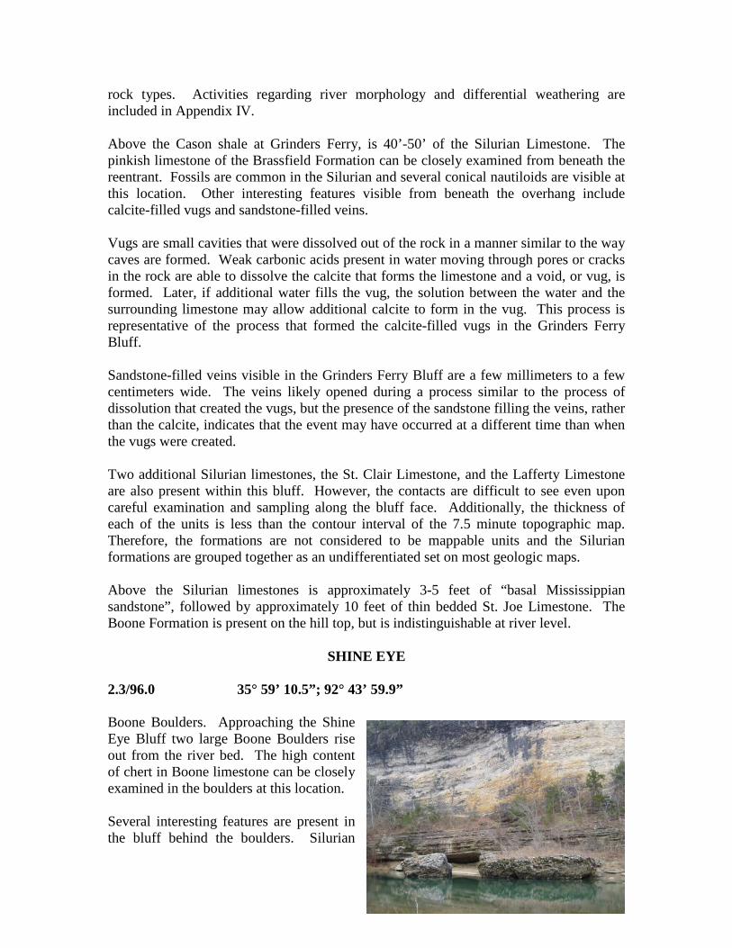
SHINE EYE
2.3/96.0 35° 59’ 10.5”; 92° 43’ 59.9” Boone Boulders. Approaching the Shine Eye Bluff two large Boone Boulders rise out from the river bed. The high content of chert in Boone limestone can be closely examined in the boulders at this location. Several interesting features are present in the bluff behind the boulders. Silurian

Limestone forms the base of the bluff at river level. The contact with the basal Mississippian sandstone is undulatory, reflecting the erosional surface (unconformity) between these two units. The sandstone is several feet thicker (5-6 feet) along the Shine Eye Bend than any other location on the river. Phosphate pebbles (up to 4 cm) in the sandstone are present in the sandstone. Additionally, the sandstone exhibits disturbed bedding features related to soft sediment deformation. Thin bedded St. Joe Limestone, approximately 10 feet thick, is present above the basal Mississippian sandstone. This is a great place to examine the contact and get a closer look at the crinoidal limestone of the St. Joe. Pyrite crystals have been observed in the St. Joe at this location. The Boone chert forms the majority of the bluff; however the contact with the St. Joe is covered by vegetation. 2.5/96.2 35° 59 20.2; -92° 44 4.3
Shine Eye Bluff. Thin to medium bedded Silurian limestone (probably of Lafferty Formation) beds rise up from the river bed at this location. Measured orientation on bedding surfaces indicate that the beds are striking approximately 10 degrees West of North and are dipping to the East at 18 degrees. The overlying Mississippian rocks appear to be relatively flat lying. It is thought by many geologists that an angular unconformity is represented here, indicating that Silurian rocks were
structurally tilted prior to deposition of Mississippian units. Other noteworthy features along the upstream end of the Shine Eye Bluff include several of the sandstone-filled fractures and voids in the Silurian units. Several of the sandstone “dikes” are several inches wide indicating that these features likely represent paleokarst features in the Silurian rocks that were filled with Mississippian sand at or near the time the sand was deposited. Continuing downstream toward the end of the bluff, older Silurian units rise above river level and the Brassfield limestone eventually forms the lower 30 to 40 feet of the bluff. Contacts between the Silurian limestones, the thin bedded St. Joe Limestone and the Boone Limestone should be visible from river level.

LANE BEND 3.0/96.7 35° 59’ 31.1”; -92° 44’ 30.1” Lane Bluff. The first cut bank in Lane Bend, Lane Bluff, provides the last large exposure the Silurian Brassfield formation. If the water level is not too high nor the vegetation too thick, this is a good area to get out and walk beneath the overhang and examine some of the features in this limestone. Calcite-filled vugs, veins, and fossils are common in the Brassfield and several of these features can be seen in this bluff. 3.6/97.3 35° 59’ 52.6”; -92° 44’ 6.4” Long Bottom Bluff. Ordovician units make their first appearance at river level here. The Fernvale limestone emerges from the river bed and outcrops approximately 20’ above river level. Silurian units have thinned to just a few feet. The basal Mississippian sandstone is approximately 3 feet thick, followed by about 15 feet of St. Joe limestone. The Boone comprises the upper 5-8 feet of the bluff. 4.0/97.7 35° 59’ 30.9”; -92° 44’ 45.8” The Fernvale drops back below river level just on the downstream end of the Long Bottom Bluff. Silurian units are exposed (approximately 5 feet thick) on the banks of the river where the Quaternary soils of the Land Bend field are not covering the rocks. The exposure thickens downstream where approximately 15-20 feet of Silurian rocks are overlain by 1-2 feet of Mississippian sandstone and 5-10 feet of St. Joe limestone. 5.0/98.7 35° 59’ 5.8’’; -92° 43’ 16.5’’ This is the final exposed section of Silurian and Mississippian rocks before heading into Gilbert. Measured orientation on the outcrop indicates that the rocks are striking 45 degrees west of north and are dipping 7° southwest. The southwesterly dip brings the older Ordovician units back up again downstream. The Fernvale limestone lines the river bed nearing the confluence with Dry Creek where enough of the Ordovician section is exposed to show the Plattin limestone. The contact of the Fernvale with the Plattin can be seen just at the mouth of Dry Creek.
GILBERT 5.5/99.2 35° 59’ 13.6’’; -92° 42’ 51.8’’ Gilbert Gravel Bar. On the downstream end, the river has eroded down to the Ordovician Plattin Limestone which is visible when the water level is low. Another good outcrop can be seen at the old town spring just below the trail along the old railroad grade that heads east out of Gilbert. Along this trail, Ordovician units continue to outcrop downstream from Gilbert, including excellent exposures of the Middle Ordovician St. Peter Sandstone/Everton Dolomite contact.

The geological story of the Ozarks Plateaus region would not be complete without discussing karst topography. Karst topography is a type of topography that is formed over carbonate rocks, such as limestone and dolostone, and that is characterized by sinkholes, caves and underground drainage. Carbonate rocks are made of calcium carbonate, which is susceptible to dissolution by weak acids. Rain water and groundwater both contain traces of carbonic acid, a weak acid derived from organic materials in the environment. As fluids carrying these weak acids travel through the cracks and joints within the rocks, the carbonate in the rock is slowly dissolved. Over time, void spaces enlarge to form caves. When the ceilings of caves collapse through to the ground surface, sinkholes are formed. In areas where karst topography is common, surface streams may often drain into sinkholes and disappear into caverns. When groundwater flowing through karst systems intersects the surface, springs emerge.
Karst systems can be small (a few feet) to very extensive, interconnected passageways that stretch for miles. These systems often exist under unique ecological conditions and support organisms specific to each area. Using special dyes, hydrogeologists can trace the movement of groundwater through karst systems in order to better understand how systems are interconnected.

Another point of geological interest in the Gilbert area is a cut-off meander bend located west northwest of town. Meander bend cutoff is fairly common in streams located in large floodplains composed of clay, silt, sand, and gravel such as the Mississippi delta, but are quite unusual in bedrock meanders. The thought is that the meanders of the Buffalo and White Rivers formed on a floodplain, then became “entrenched” into the bedrock. These entrenched meanders then remained essentially unchanged but do continue to cut toward the outside of the bend and when two bends get close enough, the river can overtop the divide and cut off the meander. Because stream migration is so slow in hard rocks this process would have taken a lot longer than typical meander bend cutoff that occurs in unconsolidated sediments as in the Mississippi Embayment. At Gilbert, a bend in the river was cut off as a narrow ridge between the two other bends on either side of the first was breached. As the river took the new shorter course, it left behind sand and gravel in the former channel which is still there today approximately 120 feet above the current river level. This shortened channel had an increased gradient which began a process of more rapid down-cutting starting at a “nick point”-essentially the difference between the level of the river above and below the old bend. As the nick point migrated upstream, it may have actually pulled the channel away from the cut bank at Lane Bend leaving a bench about 60 feet above the river. Also, terrace deposits composed of sand and gravel were stranded above the river where flood waters could no longer reach them. Caves along the river dropped to a new level and began to widen as the stream stabilized again. Cave deposits were left behind in the upper levels and are still preserved. Work is currently underway to determine an age for these various deposits which may lead to a better understanding of erosional processes in bedrock rivers.
Buffalo River channel at Gilbert before meander bend cutoff
Buffalo River channel at Gilbert just after the narrow ridge separating the two bends up and downstream of the cutoff was breached

Buffalo River channel as it is today with stranded river terraces shown
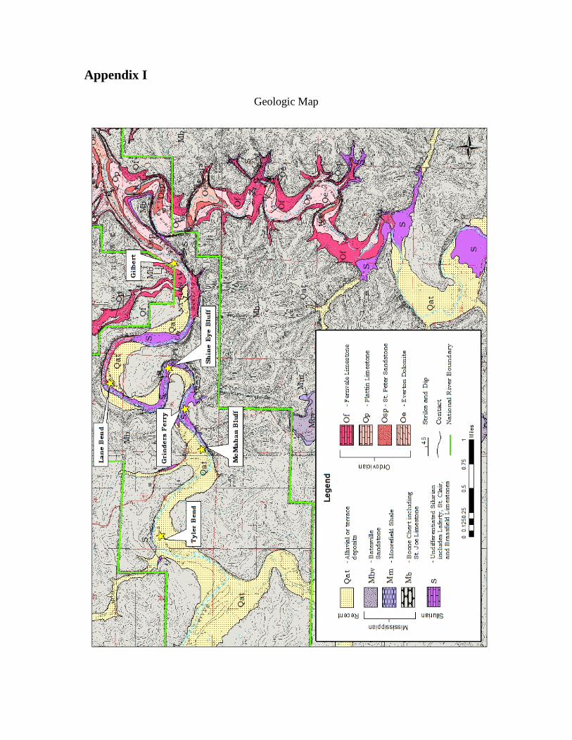
Appendix I
Geologic Map

Appendix II
Description of Geologic Units
Alluvium and terrace deposits (Quaternary) – are unconsolidated clay, silt, sand and gravel including deposits on one or more terrace levels. These deposits are only shown in areas where they do not overlap the Silurian and Ordovician units to more clearly show the structure of those units. Batesville Sandstone (Upper Mississippian, Chesterian) – is a very fine to medium-grained, subangular, moderately sorted, iron-cemented, calcareous sandstone. It is thin to medium-bedded and often cross-bedded. Fresh surfaces are dark-gray to dark-brown and weather a light-red-brown to buff. It is rarely fossiliferous, but often contains the molds where fossils have been weathered out. It is widely quarried as a dimension stone, and its plateau-like upper surface is much favored for homesites. The Batesville Sandstone is conformable with the underlying Moorefield Formation. Its thickness ranges from approximately 20-90 feet (6-24 meters), though it typically measures between 40 and 60 feet (12 and 18 meters). Moorefield Formation (Middle Mississippian, Meramecian) – is a silty shale with interbedded very thin to thin-bedded siltstone. The shaly zones are usually dark-gray to black on fresh surfaces, but weather to medium-gray with a yellow tint. The siltstone is dark-gray to dark-brown on fresh surfaces, but weathers light-gray to buff. The Moorefield Formation develops a gentle slope between the plateau-like surface of the Batesville Formation above and the Springfield Plateau (Boone Formation) below. The Moorefield is unconformable with the Boone, and typically ranges from 20-50 feet (6-15 meters) in thickness. Boone Limestone (Middle-Lower Mississippian, Osagean and Kinderhookian) – is a fine to coarse-grained crystalline to coarse-grained fossiliferous limestone interbedded with anastomosing or discontinuous, thin-bedded chert. The limestone is light to medium-gray on fresh surfaces, but weathers light to dark-gray and may contain crinoid columnals or brachiopod fossils. The chert is white to dark-gray and rarely red on fresh surfaces, but usually weathers buff to white and tripolitic. In the northeastern quadrant, the Boone Formation locally contains dendritic manganese at the base. A regolith composed of red-brown residual clay and angular chert gravel covers nearly the entire surface of the Boone and the formations below it. Karst features including springs, sinkholes and small caves are common. Bedding broadly undulates due to settling into the paleokarst features of older units. The topography of the Boone features steep, relatively flat-topped ridges that are incised by ravine-like drainages. The tops of these ridges form the surface of the Springfield Plateau. The Boone is unconformable with the underlying formations, and ranges from 250-320 feet (76-98 meters) in thickness.
St. Joe Limestone Member (Middle-Lower Mississippian, Osagean and Kinderhookian) – is a thin to medium-bedded, fine to coarse-grained, crinoidal limestone. Lithology can vary considerably between a coarse-grained, light-pink to light-gray, crystalline limestone and a fine-grained, light-green, shaly limestone with included

white or pink crinoid fragments. It ususally weathers light to dark-gray. Locally, it contains pyrite in the form of single crystals, clusters or rusty blebs where weathered. Manganese-rich zones exhibit dark-gray colors on fresh surfaces and are typically fine-grained and shaly. The St. Joe Limestone Member normally ranges from 2-8 feet (0.6-2.4 meters) in thickness, but can be as much as 20 feet (6 meters) thick along the northern edge of the map. It is mapped with the Boone because it is not considered thick enough to map as a separate unit.
Basal Mississippian sandstone – consists of discontinuous outcrops of thin to thick-bedded, fine to medium-grained, subangular to subrounded, moderately well-sorted sandstone. This unit is usually quartz-cemented, but can be cemented by calcite. The calcite-cemented zones commonly display a poikilotopic texture in freshly broken hand samples. White to light-gray or tan on fresh surfaces, it usually displays a speckled or blotchy appearance due to the presence of dark-gray to black, fine-grained sand to pebble-sized, rounded phosphate clasts and conodont fossils. Weathered exposures are dark-brown to buff. The bedding is irregular in some areas due to soft sediment deformation. During deposition the sand filled in solutioned voids and joints near the surface of the Silurian limestones which now manifest as sandstone dikes and veins within those rocks. These veins can be as small as 0.04 inch (1 millimeter) and as large as 0.5 inch (12.7 millimeters) across. The dikes are 6-8 inches (15-20 centimeters) across. The basal Mississippian sandstone is unconformable with the older formations below, and ranges from 6 inches to 6 feet (0.15 meter to 1.82 meters) in thickness. This unit was also placed in the Boone because it was not deemed mappable as a separate unit. Silurian (undifferentiated) – though present in more places than designated, these limestones are only considered mappable where their combined thickness is greater than 20 feet (6 meters). Individual formations are even less likely to form mappable units, and they are therefore treated as undifferentiated. The Silurian units crop out along Buffalo River and its major drainages, and tend to form broad domes and troughs with the Ordovician below. They are unconformable with these older units and range from 0-60 feet (0–18 meters) in thickness.
Lafferty Limestone – is a medium to thick-bedded, stylolitic, finely crystalline, sparsely fossiliferous limestone. On fresh surfaces, color ranges from light to medium-gray with light to dark-pink blebs throughout. It weathers medium to dark- gray and smooth to blocky. It contains minor pyrite crystals and rusty blebs. Its typical fossils include crinoids, brachiopods and bryzoans.
St. Clair Limestone – is a thick-bedded, coarsely crystalline, fossiliferous limestone. Its color ranges from light-gray to light-pink-gray or white on fresh surfaces, but weathers to medium-gray. It contains pyrite clusters, especially along stylolitic boundaries. It commonly contains veins of white to clear, coarsely crystalline calcite. Its typical fossils include brachiopods, ostracods, trilobites, crinoids, corals and gastropods.
Brassfield Limestone – is a thick to very thick-bedded, massive-bedded, coarsely to very coarsely crystalline, sparsely fossiliferous limestone. Color ranges from light-gray to light to dark-pink on fresh surfaces, but weathers light to medium-gray or tan to brown. Outcrops weather smooth along the streams, but blocky on the hillsides. It generally contains vugs up to 3 inches (7.6 centimeters) across that are filled with very coarsely crystalline calcite, or less commonly with calcite and a buff-colored silt or clay.

Locally, it contains veins of coarsely crystalline calcite as well. Typical fossils include crinoids, cephalopods, bryozoans and brachiopods. Cason Shale (Upper Ordovician) – is rarely exposed and of abbreviated thickness, and therefore is mapped with the Fernvale Limestone. It is composed of silty to clay shale that is light-blue-green on fresh surfaces, but weathers medium-green-gray. Locally, it contains dark-brown to black, irregularly rounded phosphate pebbles, especially near the contact with the overlying Silurian or Mississippian units. In locations where these pebbles have weathered out, they may provide the only trace of the Cason Shale in that particular outcrop. A dark-gray, fine-grained, nodular limestone with sporadic fine-grained pyrite and glauconite inclusions is exposed at the top of the Cason just beneath the Silurian bluff at Grinder’s Ferry on Buffalo River. It ranges from a few inches to approximately 10 feet (3 meters) thick near Gilbert, and is unconformable with the older units below. Fernvale Limestone (Upper Ordovician) – is a medium to coarse-grained crystalline, sparsely fossiliferous limestone. On fresh surfaces it will be white to light-gray with a light to dark-pink tint or pink mottling. It weathers light to dark- gray. The medium to very thick bedding is usually massive, and can be locally cross-bedded. Weathered exposures of the Fernvale Limestone appear as rounded, moss-covered masses that are usually quite friable. Locally, it contains barrel-shaped crinoid columnals, nautiloids and brachiopods that stand out in relief on weathered surfaces. The Fernvale is normally 10-20 feet (3-6 meters) thick, but can be as much as 40 feet (12 meters) thick, and is unconformable with the older units below. Plattin Limestone (Middle Ordovician) – is a thin to thick-bedded, micritic limestone that is intermittently fine-grained. It is very dense and usually breaks with conchoidal fracture. It is light-beige-gray to dark-gray on fresh surfaces, and weathers white to medium-gray. It can have interbedded calcareous shale up to a foot (0.3 meter) thick. This unit is resistant enough to form a persistent blocky ledge. Springs or seeps commonly emerge at or near the contact with the St. Peter Sandstone below. The Joachim Dolomite is absent on this quadrangle, therefore the Plattin Limestone rests unconformably upon the St. Peter Sandstone. It ranges from approximately 60-150 feet (18-46 meters) in thickness. St. Peter Sandstone (Middle Ordovician) – is a fine to medium-grained, angular to rounded, well-sorted, calcite-cemented sandstone, generally displaying a sugary texture. Interstitial calcite commonly exhibits a poikilotopic texture in freshly broken samples. Where the calcite has leached out, the sandstone is friable when broken. Locally it is dolomitic towards the top as on Brush Creek near Buffalo River. It is white or light-green to light-tan on fresh surfaces, but weathers dark-tan or gray. Thick to very thick-bedded, locally cross-bedded, this massive sandstone usually crops out as a distinctive smooth, concavely or convexly rounded bluff. Outcrops and especially loose boulders commonly contain Scolithos (Adams et al., 1904) trace fossils that form tubes of more resistant sandstone perpendicular to bedding that when weathered, resemble tightly-packed icicles. It is a tight sandstone that acts as a confining unit for groundwater,

thereby creating many springs and seeps along its upper contact. Travertine is locally precipitated by these springs. The St. Peter Sandstone is unconformable with the Everton Formation, and will typically display a distinctive undulating contact where its depositional channels cut down into the surface of the Everton, or perhaps where the surface was solutioned prior to deposition. Typical exposures are approximately 15-30 feet (5-9 meters) thick, but can be as much as approximately 60 feet (18 meters) thick. Everton Formation (Middle Ordovician) – is a very fine to fine-grained, thin to very thick-bedded, sandy to limy dolostone. It is medium to dark-gray on fresh surfaces, but usually weathers light-gray. Thin to medium beds of fine to medium-grained quartz sandstone, similar to the overlying St. Peter Sandstone, can be found in the upper section. The dolostone is typically mottled or banded, may contain stromatolites, mudcracks or rarely, grains of glauconite. A strong petroliferous odor is evident in freshly broken pieces. The Everton Formation only crops out along the northern edge of the map, therefore a maximum of approximately 100 feet (30 meters) is exposed.
References
Braden, A.K., and Ausbrooks, S.M., 2003, Geologic Map of the Snowball quadrangle, Searcy County, Arkansas: Arkansas Geological Commission, Digital Geologic Map, DGM-AR-00800, 1 sheet.
Clardy, B.F., and Woodward, M.B., 1966, Preliminary Geologic Map of the Marshall Quadrangle, Searcy County, Arkansas: Arkansas Geological Commission Geologic Worksheet, 1 sheet.
Glick, E.E., 1973, Preliminary Geologic Map of the Marshall Quadrangle, Searcy County, Arkansas: Arkansas Geological Commission Geologic Worksheet, 1 sheet.
Hutto, R.S., and Smart, E.E., 2008, Geologic Map of the Marshall quadrangle, Searcy County, Arkansas: Arkansas Geological Commission, Digital Geologic Map, DGM-AR-00532, 1 sheet.
Maher, J.C. and Lantz, R.J., 1952, Described Sections and Correlation of Paleozoic Rocks at Gilbert, Carver, and Marshall, Arkansas, U. S. Geological Survey, Geological Survey Circular 160, 21 p.
Maher, J.C. and Lantz, R.J., 1953, Geology of the Gilbert Area, Searcy County Arkansas: U. S. Geological Survey, Oil and Gas Investigations Map, OM-132, 1 sheet.
McFarland, J.D., 1998, Stratigraphic summary of Arkansas, Arkansas Geological Commission, Information Circular 36, p. 4-14.
Wise, O.A., and Caplan, W.M., 1988, Silurian Rocks of Northern Arkansas, Geological Society of America Centennial Field Guide – South-Central Section, p. 221-224.