geologic structure of san juan canyon and by hugh … · 2011-11-08 · geologic structure of san...
TRANSCRIPT
GEOLOGIC STRUCTURE OF SAN JUAN CANYON AND ADJACENT COUNTRY, UTAH.
By HUGH D. MISER.
INTRODUCTION.
LOCATION AND SURFACE FEATURES.
The canyon bearing the name of San Juan River, which runs through it, lies in southern San Juan County, southeastern Utah. (See index map in PI. XV.) It extends westward from the mouth of Chinle Creek to Colorado River, a distance of 63 miles in a straight line, yet it is so crooked that the distance by stream is 133 miles. The canyon has close precipitous walls as much as half a mile high and is continuous except for short distances where the river is joined by open country.
San Juan River rises in the high San Juan Mountains of Colorado, flows southwestward into New Mexico, and after turning back into Colorado enters Utah, where it flows west, passes through the can yon, and joins Colorado River near the Utah-Arizona line.
The region trenched by the canyon is a part of the Colorado Plateau, characterized by canyons, cliffs, mesas, and buttes. The general upland surface, averaging 5,000 to 6,000 feet above sea level, is not a single plateau but consists of several plateaus. Each plateau appeal's regular and continuous in a panoramic view, yet they are trenched by the crooked canyons of San Juan River and its many tributaries. The intercanyon areas are gently rolling to rugged and contain no extensive tracts of level land. The solitary peak of Navajo Mountain, the only mountain standing near the San Juan in Utah, towers to a height of 10,416 feet.
The roughness of the region, combined with the meager rainfall, the almost total absence of soil, and the scantiness of grass, sage brush, pine, pifion, and cedar, make it a desert waste, practically all of which reveals bare rocks. The rocks are of many colors gray, buff, brown, red, pink, lavender, green, yellow and also show many tints and shades of each color, but in any landscape view buff, brown, and red predominate, and the exposed edges of the gray rocks are generally stained with these three colors.
115

116 CONTRIBUTIONS TO ECONOMIC GEOLOGY, 1923-1024, PART II.
The rocks, which generally lie in a horizontal or nearly hori zontal position, do not all offer the same resistance to weathering, and for this reason the character of the surface features depends in large measure on the character of the rocks. Thick beds of hard sandstone and limestone form vertical cliffs, above which there are benches or plateaus, whereas shale produces slopes or badland areas. Stream channels cut entirely in sandstone and limestone are confined in narrow steep-walled canyons; but the channels that are cut into thick beds of shale are bordered by wide valleys whose slopes are surmounted by precipitous cliffs of the overlying hard sandstone.
ACCESSIBILITY.
The part of Utah lying south of San Juan Kiver and east of the 110th meridian has been set aside for the use of the Navajo Indians; the bulk of the reservation, however, lies in Arizona and New Mexico. The former Piute Indian Eeservation, which was a belt of country lying between the San Juan and the Utah-Arizona line and extend ing from Colorado Eiver eastward to the 110th meridian, has recently been returned to the public domain, though it is planned to set aside for the use of the Indians the tracts they actually occupy.
The country lying south of the river in the Navajo Indian Eeserva tion is not public land and not subject to the public-land laws; but the region north of the river and also the former Piute Indian Eeser vation are parts of the public domain, to which the agricultural and mineral land laws are applicable.
San Juan Canyon was inhabited by neither white people nor In dians in 1921, but much evidence indicates that the more accessible parts have been the temporary abode of a few Indians with flocks of sheep and that prospectors have visited the canyon in search of oil and placer gold. The country adjacent to the canyon is inhabited by few people.
An area fully 50 miles square lying north of the lower San Juan is almost uninhabited, though it is visited during winter by herds men with their cattle. The only settlements along its southern edge are Goodridge and Mexican Hat, each of which has a store with a small stock of merchandise. Bluff and Blanding, the nearest settle ments on the east, are thriving villages in the midst of irrigated areas.
Goodridge and Mexican Hat, which are field headquarters for oil men who visit the San Juan oil field, are generally reached by two overland routes, one by way of Bluff and the other by way of Kayenta, Ariz.
Bluff may be reached by automobile stage from Thompson, Utah, on the Denver & Eio Grande Western Eailroad, 143 miles by road to the north, by going through Moab, Monticello, and Blanding (for-

GEOLOGIC STftUCOmE OF SAN JtfAN CANYON, tJTAS. 117
merly called Grayson). It may also be reached by automobile stage from Dolores, Colo., on a narrow-gage line of the same railroad. The route from Dolores runs in a west-northwesterly direction to Monticello, a distance of about 75 miles, and then south through Blanding to Bluff. From Bluff a road runs to Mexican Hat, a dis tance of 25 miles, and then on to Goodridge, 2£ miles (by road) farther south. This road is used by a few automobiles, but on ac count of washouts it is occasionally rendered impassable except for pack animals.
From Goodridge a wagon road runs in a southwesterly direction, crosses the San Juan over a suspension bridge half a mile west of the village, and then runs through Monument Valley and Pass to Kayenta, Ariz., the distance being about 50 miles by road. On ac count of deep sand and washouts only one automobile had made the trip from Kayenta to Goodridge before 1921.
Kayenta may be reached by automobile from Flagstaff, Ariz., on the Atchison, Topeka & Sante Fe Railway, 155 miles by road to the southwest. The road is in good condition between Flagstaff and Tuba but poor the rest of the way. Kayenta may also be reached by automobile over sandy roads by way of Chinle, Ariz., from Gallup, N. Mex., also on the Atchison, Topeka & Sante Fe Eailway, a distance of 190 miles.
The small number of roads and trails that penetrate the rough canyon country west of Goodridge have been used by few wagons and fewer automobiles. The only practicable means of transporta tion through most of the country is by pack train. Whatever route or means of conveyance is chosen, the services of a guide familiar with trails, water holes, springs, and streams are indispensable.
PREVIOUS GEOLOGIC WORK.
The San Juan oil field, which lies north of and adjacent to San Juan Canyon, near Mexican Hat and Goodridge, was visited in 1909 by H. E. Gregory * and in 1910 by E. G. Woodruff.2 Their reports give full information about the field. J. D. Sears visited the field in 1920 and prepared a report for the use of the land classification board of the Geological Survey. Gregory during his field work in the Navajo country from 1909 to 1913 visited San Juan Canyon at places below the oil field and obtained a wealth of information on the geography and geology of the region.3 A description of some features of San Juan River, with velocity and discharge measure-
1 Gregory, H. E., The San Juan oil field, Utah: U. S. Geol. Survey Bull. 431,, pp. 11-25, 1911.
2 Woodruff, E. G., Geology of the San Juan oil field, Utah.: U. S. Geol. Survey Bull. 471, pp. 76-104, 1912.
3 Gregory, H. E., The Navajo country: U. S. Geol. Survey Water-Supply Paper 380, 1916; Geology of the Navajo country: U. S. Geol. Survey Prof. Paper 93, 1917.

118 CONTRIBUTIONS TO ECONOMIC GEOLOGY, 1923-1924, PAET II.
ments, has been given by R. C. Pierce.4 A brief summary of the oil field was given by F. R. Clark 5 in 1920.
All the reports here mentioned have been consulted and freely used by the writer in preparing the present report.
PRESENT INVESTIGATION.
The present report gives the data obtained by the writer during his descent of San Juan Canyon as a member of a Geological Sur vey party in 1921. The exploration of the river by this party had as its primary object the mapping and study of the river in connection with proposed power and storage projects along San Juan and Colo rado rivers.
The exploration party of seven men was headed by K. W. Trimble, topographic engineer. Other members of the party were Robert N. Alien, recorder; H. E. Blake, jr., and Hugh Hyde, rodmen; Bert Loper, boatman; Heber Christensen, cook; and the writer, geologist. Wesley Oliver, of Mexican Hat, served as packer for the party and twice a month brought mail and provisions by pack train to speci fied accessible places west of Goodridge.
The party descended the river by using two 16-foot flat-bot tomed rowboats, beginning the voyage near Bluff July 18 and reaching the mouth of the river October 3. During the trip the writer made detailed and reconnaissance geologic studio not only along the river but to points as far as 25 miles from the river.
ACKNOWLEDGMENTS.
The writer desires to acknowledge his indebtedness to K. W. Trimble for his cooperation and interest in geologic problems in the field,'and to the other members of the party for assistance and in formation during and after the canyon trip. Acknowledgment is also due to officials of oil companies for information concerning their activities in the region.
GEOLOGY.
GENERAL FEATURES.
The rocks in and near San Juan Canyon are bare of soil and vege tation at most places and thus offer an unexcelled opportunity for study. They include both igneous and sedimentary rocks.
4 Pierce, R. C., The measurement of silt-laden stream*1 : U. S. Geol. Survey Water- Supply Paper 400,, pp. 39-51, 1917.
5 Clark, F. R., The Farnham anticline, Carbon County, Utah: U. S. Geol. Survey Bull. 711, pp. 10-11, 1920.

GEOLOGIC STRUCTURE OF SAN JUAN CANYON, UTAH. 119
The igneous rocks are found at several localities in the east end of the region here described at Alhambra Rock, where there is a high dark volcanic neck and associated dikes; 3 miles north of Mexican Hat and also 4 miles south-southeast of Goodridge, where there are dikes; and 2 miles south of the mouth of Chinle Creek, where there is a volcanic neck. (See PL XV.)
The sedimentary rocks, which are generally horizontal or inclined at low angles, are of Pennsylvanian, Permian, Triassic, Jurassic, Cretaceous (?), and Quaternary age and have been grouped into a number of formations. The succession and character of the sedi mentary rocks are graphically represented in the accompanying columnar section (fig. 18) and the distribution of the different formations is shown on the geologic map (PI. XV). A fuller dis cussion of the age and correlation of the rocks is given in another report.0 The oldest formations are exposed at and near Good- ridge and Mexican Hat, in the San Juan oil field. Because these and the younger formations dip in all directions from the oil field suc cessively younger beds are found both upstream and downstream from the field. The different formations are described below in the order of their age, the oldest first. Their structure is described on pages 131-140.
THE BOCKS.
GOODKIDGE FORMATION.
The Goodridge formation, of Pennsylvanian age, is widely exposed on the crests of the Mitten Butte and Raplee anticlines, in the San Juan oil field. (See PL XV.) In the western anticline (the Mitten Butte) the canyon of San Juan River has been carved into this formation to a depth of 1,338 feet without revealing its base, and in the eastern anticline (the Raplee) the canyon has been carved into it to a depth of 1,000 feet. The formation is also exposed con tinuously down the canyon from the oil field as far as the mouth of Grand Gulch, a distance of about 25 miles by stream. Within this distance it forms the lower parts of the canyon walls, and its top be comes lower and lower toward the west on account of the low westward dip. As a result of this dip the top of the formation passes beneath the river and disappears near the mouth of Grand Gulch. A well 1,900 feet deep in Johns Canyon, which is said to have been started on the top of the Goodridge formation, was probably drilled its entire depth in the Goodridge. The formation consists of sandy shale, sandstone, and cherty limestone, all interbedded and revealed in
8 Longwell, C. R., Miser, H. D., Moore, R. C., Bryan, Kirk, and Pajge, Sidney, Rock formations in the Colorado Plateau of southeastern Utah, and northern Arizona: U. S. Geol. Survey Prof. Paper 132, pp. 1-23, 1923 (Prof. Paper 132-A).

120 CONTRIBUTIONS TO ECONOMIC GEOLOGY, 1923-1924, PAET II.
Generalized sectionshowing strata inSan. Juan oil field
B»E>0. Woodruff,U. 8. GeoL Survw
Bulletin 471, Plate VHl,1912
Generalized section of rocks ef the Navajo country By H. E. Gregory, U. &. GeoL Survey
Professional Paper 931 1917
Generalized sectionof rocks along and near
San Juan Canyon
McElmo formation ZSO+feet
Shefe am/' sandstone ITQ-XO feet
Nsvajo sandstorm 675-1,000 feet
Win^atesandstone
27S-*oo feet
Chinle formation
800-iPOOfeet
Shlnaramp conglomerate 0-ZWftrt.
Uueof/fOKHlTY '.
UNCONFORMITY
Goodrid^e formation
---'
,^-^>-^ < '"
x^
.''s*
S"
-"-^/ /'S
lly(?)
^"X1
/'
^'
-
a13 }
3ISSVIMJ.
NVINVAIASNN;
£
_
iM:
rrr-.
H
,.._1^-
IP
JSSvT
^iB^
S1MH
3^:-J>'-""-i
II" H ^
,1,1,1,1?
&m
V
,-- "*
... .--..--La Platasandstone 500 feet
Doloresshale 1,332 feet
ONCONFOPMITY
Oljato
member 380 feet
Moencopie ftrmation'1,640 feet
Goodnd^e ftrmation 1^41 feet
-
"
X
\
A\
-7-
/
(
f
ey
-
uS9* 3
y0)n
E
: *y-
1
Z
<
USNH3J 1
SJS^J..
^
ggffl'm:::::::r::::'
IK18!H-nv^T;
M
^Bi&S?ft
r-------
-nr^
rijtjMA gg
mu'jaj
agfet:.' .'.'.'
.1111t ' ; l ^
grgg I'l.'l"!
'; ! '.'''.
Me El mo i formation400-700 ftet
Navaio
400- 3 1,000 feet £
(h
Todilto t6
3-EOOftet ^
Win^ate sandstom
Chinle formation 1,182 feet
/Shinarump . M-IDO ftal
UNCOHrOKHITT
DeChelly z sandstone^
Moenkopi ftrmation300-500 feet
Goodridge
I^OO.ffeet
^*- -T .1 ! p g^sa^t n r
L The teds that are between the Kavafc sandstone taii, McElmo formation in much of the Colorado Plateau were not considered distinct formations by Gregory along Glen and San Juan canyons. He there Included them in his McElmo formation <.
2. The DeChelly sandstone in and near Canyon DeChelly, the type locality, is said by Ba&er and Darton to be equiv alent to Coconino sandstone. If so the Moenkopi in this section occupies position of the Supal(?) formation
FIGCHH 18. Generalized columnar sections of the rocks in San Juan Canyon and theadjacent country, Utah.

GEOLOGIC STRUCTURE OF SAN JUAN CANYON, UTAH. 121
every exposure. Most of the shale is in reality nonfissile mudstone. Limestone predominates in the lower 500 feet and sandstone and shale in the upper portion. Ked is the predominant color of the beds in the upper 700 feet, but gray is the prevailing color in the lower part.
The even bedding and interbedding of the limestone, shale, and sandstone give rise to numerous cliffs and benches in the walls of the canyons that trench the Goodridge formation. The cliffs are formed by limestone and hard sandstone, and the benches are formed by shale and soft sandstone. (See Pis. XVI-XVIII.)
Sandstone and limestone beds of the formation supply the oil in the San Juan oil field. Some of the oil-bearing beds are near the top of the formation, but others are much deeper, the lowest being 1,300 feet below the top. The oil at the oil seeps in the canyon is also derived from the Goodridge. Sections of the formation and the po sition of some of the "oil sands" in the sections are given on pages 127-130,145.
SUPAI (?) FORMATION.
The Supai (?) formation, of Permian age, which overlies the* Good ridge formation, is exposed in and around the San Juan oil field and down San Juan Canyon almost to the mouth of Moonlight Creek. Lime and Gypsum creeks drain large areas underlain by this formation. Farther west the exposures occur in steep slopes that are surmounted Jby vertical cliffs of the next younger formation, the Coconino sandstone, which caps Cedar and Polly mesas and other high areas to the west and south. (See PL XV.) At the base of such slopes there is everywhere a bench, wide or narrow, that is floored by the topmost beds of the Goodridge formation. The road leading west past Cedar Point to the mouth of Slickhorn Gulch runs on such a bench. (See Pis. XVII, B, and XVIII.) The Supai formation consists of a red sandy shale and earthy sandstone. The thickness as measured at the mouth of Slickhorn Gulch is 380 feet. It was not measured farther east by the writer but is probably much the same there.
COCONINO SANDSTONE.
The Coconino sandstone, of Permian age, floors the broad west ward-sloping plateau areas that lie on both sides of San Juan River between the Clay Hills and the San Juan oil field. These areas are trenched by numerous canyons, including Grand Gulch, Slickhorn Gulch, and the canyon of Moonlight Creek. On the east they are limited by a precipitous impassable escarpment several hundred feet high, which separates them from the lower plateau in which the oil field is situated. To parts of the plateau north of the river the names
CON-TfclBtJTlONS TO ECONOMIC GEOLOGY, 1923-1924, PAfc!? II.
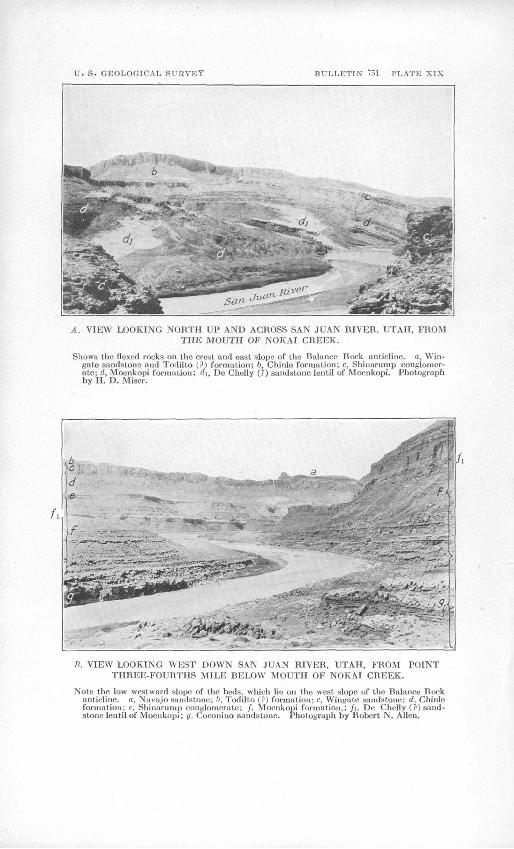
Grand Flat, Polly Mesa, and Cedar Mesa have been applied; and the plateau south of the river, which is surrounded on its west and south sides by higher country, has been called Monument Valley.7 A small isolated exposure of the Coconino sandstone occurs on the crest of the Balance Rock anticline, in the lower part of San Juan Canyon, at Zahns Camp. (See Pis. XVII, E, XVIII, and XIX, B.)
Near the mouth of Moonlight Creek the thickness of the sandstone is about 600 feet; at the mouth of Slickhorn Gulch it is about 400 feet; and the exposed thickness near Zahns Camp is 144 feet or less, depending1 on whether the upper 89 feet of gray to red sandstone and shale belongs with the Coconino sandstone or with the next suc ceeding formation, the Moenkopi formation. According to Wood ruff,8 east of Cedar Mesa the sandstone grades completely into red sandy shale, which is present on the southeast side of the oil field. This shale and the equivalent sandstone were included by Woodruff 8 and Gregory 9 in their Moenkopi formation of south eastern Utah.
The Coconino sandstone is massive and its color creamy white, though on Cedar Mesa much of it is tan. The grains are fine to me dium in size, and, as a rule, the cement of calcium carbonate is suf ficient to make the rock firm, although in places it is friable.
MOENKOPI FORMATION.
The Moenkopi formation is of Triassic age and is overlain by the Shinarump conglomerate. Within the area shown on the map it is widely exposed along the river between Moonlight Creek and Spen cer Camp, and it is also exposed along Nokai and Copper creeks, along the eastward-facing escarpment of the Clay Hills, and along the west base of Comb Ridge. The beautiful Train and Organ rocks of Monument Valley are isolated outliers of the formation.
The formation, being easily eroded, forms badland slopes and steep fluted cliffs underneath a capping of the resistant Shinarump con glomerate.' (See PI. XIX.)
Near Clay Hill Crossing, Piute Farms, and Zahns Camp it ranges in thickness from 765 to 920 feet and consists principally of even- bedded red sandy shale and earthy sandstone, with veinlets and lenses of gypsum. South and southwest of Piute Farms a thin bed of cream-colored sandstone is found near the middle of the formation. The bed gradually thickens toward the south, developing into a mas sive cross-bedded member which in Train Rock is estimated to have
7 Gregory, H. E., U. S. Geol. Survey Water-Supply Paper 380 and Prof. Paper 93.8 Woodruff,. E. G., Geology of the San Juan oil field, Utah.: TJ. S. Geol. Survey Bull,
471, pp. 86-87, 1912.0 Gregory, H. E., Geology of the Navajo country: U. S. Geol. Survey Prof. Paper 93,
pp. 29-30, 1917.

GEOLOGIC STRUCTURE OF SAN JUAN CANYON, UTAH. 123
a thickness of about 200 feet. In the cliffs of the Moenkopi forma tion this sandstone forms a most conspicuous cream-colored band between the brick-red bands of the overlying and underlying parts of the formation. (See PL XIX.) The sandstone disappears en tirely near Piute Farms and was not recognized between Clay Hill Crossing and Eed House. This sandstone is apparently the sandstone to which Gregory applied the name De Chelly in and near Monu ment Valley, though Hager 10 and Darton 11 consider the De Chelly sandstone in and near its type locality, Canyon De Chelly, in north eastern Arizona, to be equivalent to the Coconino sandstone of the Grand Canyon section. Gregory treated the De Chelly sandstone as a separate formation, because in most of the region he studied south of the San Juan he found it above the shale called by him the Moen kopi, and immediately underneath the Shinarump conglomerate. The De Chelly sandstone, according to him, is present on the east side of the San Juan oil field, where it is red and thins out toward the north.
SHINARUMP CONGLOMERATE.
The Shinarump conglomerate, of Triassic age, is widely exposed along San Juan Canyon between Piute Farms and Piute Creek and also along Nokai and Copper creeks. It is apparently absent at all places between the canyon and Eed House, to the north, and near the entrance to the canyon.
The formation, because of its hardness and its occurrence between two soft shaly formations, produces precipitous cliffs and also floors benches above and back of the cliffs. (See PL XIX.) The forma tion ranges in thickness from a feather edge to 220 feet; the greatest thickness was measured on the river near the mouth of Nokai Creek. It consists of massive gray cross-bedded coarse-grained sandstone and lenses of conglomerate with well-rounded pebbles of quartz and quartzite as much as 2 inches in diameter. Fossil logs that have been partly silicified are numerous in the lenses of conglomerate; and greenish-gray shale is an abundant constituent, especially near the top of the formation.
CHINLE FORMATION.
The Chinle formation, of Triassic age, succeeds the Shinarump conglomerate. It is exposed in a narrow belt along the west base of Comb Kidge and is widely exposed in San Juan Canyon and the side canyons west of Piute Farms. It also crops out along the east face of the Clay Hills. The exposures produce long badland slopes
10 Hager, Dorsey, Oil possibilities of the Holbroofc area in northeast Arizona (a private publication), 1921.
u Darton, N. H., manuscript report101874° -25 9

124 CONTRIBUTIONS TO ECONOMIC GEOLOGY, 1923-1924, PART II.
that are cut by ravines and gullies and strewn with landslides and huge jagged boulders derived from the sandstone cliffs above. (See Pis. XIX and XX.)
The thickness ranges from 800 to 1,000 feet. Thick marly shales of gray, pink, lavender, yellow, and numerous other vivid colors make up the bulk of the formation, and where they are not concealed by landslides, soil, and boulders produce landscape views of amazing beauty. Cherty and conglomeratic limestone and sandstone are common, especially near the top of the formation. Silicified logs, some of which are 40 feet or more in length and 4 feet in diameter, are numerous at places.
WINGATE SANDSTONE!.
The Wingate sandstone, of Jurassic age, is one of the most con spicuous cliff makers of the region. It is from 275 to 400 feet thick, and commonly the greater part0 of the total thickness appears as a single massive unit that is cut by vertical joints and presents an impassable palisade-like wall at the top of the long badland slopes of the Chinle formation. The sandstone forms the western part of Comb Ridge and is widely exposed in the country of high plateaus and mesas west of Piute Farms. (See Pis. XVI, XIX, and XX.)
At some places the lowermost beds are lenticular and are in part conglomeratic. The massive cliff-making portion, which averages about 300 feet in thickness, has indistinct and continuous bedding and is cross-bedded on a large scale. The sandstone is composed of fine rounded sand grains. The color of the sandstone on exposed surfaces gives the cliffs a striking appearance, even in a "painted desert"; it is dark brown and at times assumes a vermilion color. On unweathered surfaces the rock is buff. The darker color ordi narily seen on cliffs is due to a coat of iron oxide along the joint faces.
TODILTO (?) FORMATION.
The Todilto (?) formation, also* of Jurassic age, ranges from perhaps 100 feet to 200 feet in thickness and consists of light to dark brown sandstone in comparatively thin beds, brown sandy shale, thin lenses of gray limestone, and lenses of conglomerate with sand stone pebbles. The member as a whole is very resistant; it almost everywhere caps the cliffs of the underlying Wingate sandstone and floors wide and narrow benches wherever the overlying Navajo sandstone has been eroded from it. (See Pis. XIX and XX.) The sandstone is exposed as a narrow belt near the middle of Comb Ridge and as irregular areas and crooked belts in the country of high plateaus and mesas west of the Piute Farms. These areas and
GEOLOGIC STRUCTURE OF SAN JUAN CANYON, UTAH. 125
belts have dark-brown and vermilion colors and at a distance they frequently display a tint of lavender.
NAVAJO SANDSTONE.
The Navajo sandstone, of Jurassic age, forms the eastern part of Comb Ridge and caps most of the high plateaus and mesas west of Piute Farms. It forms great tracts of almost impassable badlands, in which domes, " mosques," " minarets," and canyons are common features. (See Pis. XIX and XX.) Caves, alcoves, and arches are conspicuous in the canyon walls of this sandstone, and it forms a number of natural bridges, notably the Rainbow and Owl bridges, near Navajo Mountain. The two small natural bridges near San Juan River are also in this sandstone. One of these is on the rim of the right canyon wall of the river 2 miles below the mouth of Piute Creek, and the other is on the rim of the canyon wall of the high abandoned river channel that runs from a point near the mouth of the San Juan northward about 1 mile to the Colorado.
The sandstone is thickest on Wilson Mesa, where it is 800 to 1,000 feet thick. The usual color is tan or buff, but on Wilson Mesa the upper part of the formation is gray to buff and in places has a pink ish tint. The sand grains are small and rounded and are loosely held together by a cement of calcium carbonate. Cross-bedding on a large scale characterizes the greater part of the formation. True bedding planes are present but not distinct, so that the entire forma tion stands in some cliffs with the appearance of a single massive layer. Lenses of gray compact limestone from 2 to 5 feet thick are common in all parts of the sandstone, especially near the mouth of the San Juan. The lenses at some places contain chert. They ex tend laterally from a few hundred feet to half a mile.
OTHER ROCKS OF JURASSIC AGE.
The Navajo sandstone is overlain by 50 to 250 feet of red gypsif- erous and calcareous shales and thin sandstones at Bluff and along Glen Canyon below the mouth of the San Juan.
These gypsiferous beds at Bluff and along Glen Canyon are suc ceeded by a massive cross-bedded sandstone, which in some parts is red, in others gray or white, and in others mottled red and white. At Bluff the sandstone is from 170 to 270 feet thick, and along Glen Canyon it is apparently in places as much as 500 feet thick.
McELMO FORMATION.
The McElmo formation, of Cretaceous (?) age, is exposed near Bluff, where it consists of gray, red, and green shale and thin sand stone with two heavy beds of conglomerate, making an incomplete

126 CONTRIBUTIONS TO ECONOMIC GEOLOGY, 1923-1924, PART II.
section several hundred feet thick. This and later formations of Cretaceous age are exposed along the Colorado beyond the limits of the area under discussion.
TERRACE GRAVELS.
Gravel of Quaternary age floors terraces of small extent at nu merous places in the canyon, especially in the several wide open stretches, and partly floors an abandoned canyon near the mouth of the river through which the San Juan or the Colorado formerly flowed. The largest areas of gravel are in the wide stretch extending from Clay Hill Crossing to Piute Farms.
The gravel floors terraces at several different elevations, up to about 600 feet above the river. Most of it was deposited by the San Juan, but part by side streams when their channels stood at the elevations of the terraces. The usual thickness of the gravel de posits is 10 feet or less, but at some places they are 20 feet and at a few places as much as 100 feet thick. The deposits are all similar in character and consist mostly of limestone pebbles from the Good- ridge formation of the San Juan oil field and quartzite, conglomer ate, and crystalline rocks from the San Juan Mountains of south western Colorado. Much or all of the terrace gravel at and near the mouths of side streams consists of sandstone and limestone pebbles that have been contributed by these streams. It is thus of local origin and differs in character from gravel of the common type.
The pebbles of the gravel deposits range in size from pebbles a small fraction of an inch in diameter to cobbles a foot in diameter, with the largest near the base of the deposits. The usual size is probably between 1 and 3 inches in diameter. All are well rounded and generally flattened. Some of the deposits near the mouths of side streams contain boulders as much as 8 feet in diameter, and one boulder 10 feet in diameter was observed. The pebbles are poorly to firmly cemented together by earthy calcium carbonate, which is concentrically banded around them. At many places the shells of calcium carbonate that have become detached from the pebbles are conspicuous on the surface, for they resemble shallow cups.
STREAM DEPOSITS OF RECENT AGE.
Recent stream deposits consisting of sand, gravel, cobbles, and boulders occur along the banks of San Juan River or on the river bed. They do not occupy large areas but possibly attain at some places a thickness of 100 feet,

U. S. GEOLOGICAL SURVEY BULLETIN" V51 PLATE XVI
A. VIEW LOOKING NORTHEAST UP SAN JUAN KIVKK. UTAH, FROM A. POINT ABOUT 1 MILE SOUTH OF THE MOUTH OF CHINLE CREEK.
Shows the steeply dipping rocks on the east slope of the Raplee anticline. The oldest beds, to the left, are in the Goodridge formation and the youngest, to the right, are in the Nava.jo sandstone. Photograph by II. D. Miser.
B. VIEW LOOKING SOOTHEA.ST TOWARD AND BEYOND THE MEXICAN HAT,UTAH.
The undifTerentialed Supai f?), Coconino, and Moenkopi formations lie in the Mexican Hat syncliue in the foreground; and the Goodridge formation rises from underneath them in the Raplee anticline in the distance. Photograph by Robert N. Alien.

U. S. GEOLOGICAL SURVEY BULLETIN 751 PLATE XVII
A. VIEW AT THE GOODRIDGE BRIDGE, SAN JUAN RIVER. UTAH, LOOKING DOWNSTREAM THROUGH A GORGE PRODUCED BY THE "GOODRIDGE" OIL SAND, IN WHICH THERE ARE SMALL OIL SEEPS.
This and other beds of the Goodridge formation dip about 2° SE. (upstream) and lie on the west side of the Mexican Hat syucline. Photograph by Robert N. Alien.
B. VIEW LOOKING WEST INTO SAN JUAN CANYON, UTAH, FROM HEAD OFHONAKER TRAIL.
Cedar Mesa, to the right, is formed by Coconiuo sandstone (ft). Supai (?) formation (&) is in lower half of escarpment of Cedar Mesa. Canyon is in Goodridge formation (c). Photo graph by H. D. Miser.

TJ.
S.
GE
OL
OG
ICA
L S
UR
VE
YB
UL
LE
TIN
751
PL
AT
E
XV
III
A.
VIE
W
LO
OK
ING
E
AS
T
UP
SA
N JU
AN
C
AN
YO
N,
UT
AH
, F
HO
M
A P
OIN
T 2 M
ILE
S B
EL
OW
M
OU
TH
O
F JO
HN
S
CA
NY
ON
.
The u
pp
er, sun
lit part o
f the can
yo
n w
all is form
ed b
y th
e S
upai
(?) fo
rmatio
n
and
Co
con
ino
sand
ston
e, an
d
the
low
er, d
ark
part
by
the
Goodrid
ge
form
ation.
Ph
oto
gra
ph b
y H
. D. M
iser.
B.
VIE
W
LO
OK
ING
W
OR
TH
IES
T
DO
WN
S
AN
JU
AN
C
AN
YO
N,
UT
AH
, T
OW
AR
D
TH
E
MO
UT
H
OF
S
LIC
KH
OR
N
GU
LC
H.
No
te bould
er bar an
d rap
id a
t mo
uth
of g
ulch
. A
well
267 feet d
eep, d
rilled y
ears ag
o o
n th
e low
er end
o
f th
e bar, o
btain
ed
a show
ing
of oil.
Man
y oil
seeps
occu
r aloriK
th
e riv
er ab
ov
e th
is locality
, fi,
Coco
nin
o san
dsto
ne; b, S
upai (?) fo
rmatio
n;
r, G
oodrid
ge
form
ation
. P
hoto
gra
ph b
y R
ob
ert N. A
lien.
TJ. S. GEOLOGICAL SURVET BTTLLETIN T.il PLATE XIX
A. VIEW LOOKING NORTH UP AND ACHOSS SAN JUAN RIVER, UTAH, FROM THE MOUTH OF NOKAI CREEK.
Shows the flexed rocks on the crest and east slope of the Balance Rock anticline, a, Win- gate sandstone and Todilto (?) formation; b, Chinle formation; c, Shinarurnp conglomer ate; d, Moenkopi formation; di, De Chelly (?) sandstone lentil of Moenkopi. Photograph by H. D. Miser.
B. VIEW LOOKING WEST DOWN SAN JUAN RIVER, UTAH, FROM POINT THREE-FOURTHS MILE RELOW MOUTH OF NOKAI CREEK.
Note the low westward slope of the beds, which lie on the west slope of the Ralance Rock anticline, a, Navajo sandstone; b, TodilLo (?) formation; c, Win^atc sandstone; d, Chinle formation; e, Shinarump conglomerate; /, Moenkopi formation,; /i, De Chelly (?) sand stone lentil of Moenkopi; g, Coconino sandstone. Photograph by Robert N. Alien.

TJ. S. GEOLOGICAL SURVEY BULLETIN 751 PLATE XX
A. VIEW LOOKING SOUTH FROM TIIR LOWER END OF THE CHEAT BEND, SAN JUAN RIVER, UTAH.
B. VIEW LOOKING NORTHWEST UP WILSON CREEK WEAR SAN JUAN.RIVER, UTAH.
The slabby Todilto (?) formation lies between the dome-forming Navajo sandstone, above, and the Wingate sandstone, below. These formations lie on the east side of the Navajo Mountain anticline and are broken by a short fault, whose position is indicated by a dashed Hue. Photograph by Robert N. AHeii.

GEOLOGIC STRUCTURE OF SAN JUAN CANYON, UTAH. 127
SECTIONS.
Section of Goodridge formation at Honaker trail on San Juan Riv.er.
tThis is the type locality of the formation.]Feet.
1. Gray hard fine-grained limestone; top bed of formation_ 22. Red earthy sandstone and sandy shale; gentle slope__ 313. Massive gray pitted cross-bedded sandstone (Baby oil
sand) __ __,____________________ 2-124. Red earthy sandstone;' forms gentle slope. Layer of
gray limestone 1 foot thick near top__,______ 155. Gray pitted soft friable sandstone; forms ledge
("Goodridge" oil sand)_________________ 186. Gray coarse-grained fossiliferous limestone_______ 27. Red earthy sandstone and sandy shale; forms slope__ 258. Massive medium-grained gray limestone; sandy and
cross-bedded; forms ledge at head of Honaker trail 209. Red and purple shales and sandstones; gentle slope__ 63
10. Gray pitted soft cross-bedded sandstone (Third oilsand) _________________________ 5
11. Red and purple shales and sandstones; gentle slope_ 3512. Gray pitted cross-bedded soft sandstone; ledge (Men-
denhall oil sand)_____________________ 3013. Red shale and sandstone; slope________________ 5614. Gray thin-bedded medium-grained limestone; ledge;
Woodruff's fossil lot 158 obtained from this bed. This is base of the upper Goodridge fauna__________ 10
15. Red and lavender sandy shales; slope________ 2716. Gray sandy limestone with black flint nodules ____ 1217. Gray coarse-grained limestone with nodules of red
flint; the base of this bed appears to be the horizon of the Little Loop oil sand. Woodruff reports a thick ness of 3i feet of the sandstone on the Honaker trail 8
18. Red, lavender, and gray sandy shales; slope _ 5019. Red, lavender, and gray sandy shales containing coarse
grained fossiliferous limestone in upper half____ 3520. Compact dove-colored limestone; massive at top; grades
downward into shaly limestone; contains nodules of jasper 12i
21. Massive compact dove-colored limestone with nodules ofvariegated chert _ 20
22. Gray and black shales with thin layers of limestone 1023. Drab knotty limestone and some gray shale 1824. Cherty drab limestone and some gray shale 2525. Gray and lavender shales and some thin beds of knotty
limestone; slope 7826. Massive gray coarse-grained limestone, free from chert_ 1527. Limy gray shale- 1028. Cherty drab limestone _____ 629. Gray shale with thin layers of drab limestone near top__ 1130. Massive compact dove-colored limestone; breaks with
conchoidal fracture 8
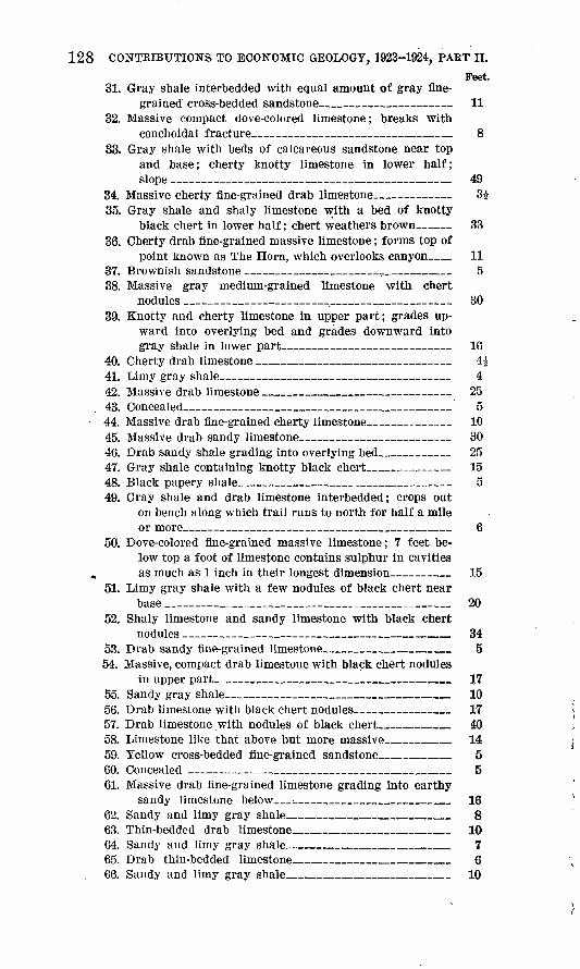
128 CONTRIBUTIONS TO ECONOMIC GEOLOGY, 1923-1924, PAET II.
Feet.31. Gray shale interbedded with equal amount of gray fine
grained cross-bedded sandstone__________ _ 1132. Massive compact dove-colored limestone; breaks with
conchoidal fracture _____ _ 833. Gray shale with beds of calcareous sandstone near top
and base; cherty knotty limestone in lower half; slope __________________________~_ 49
34. Massive cherty fine-grained drab limestone_ 3i35. Gray shale and shaly limestone with a bed of knotty
black chert in lower half; chert weathers brown___ 3336. Cherty drab fine-grained massive limestone; forms top of
point known as The Horn, which overlooks canyon__ 1137. Brownish sandstone ______________,._______ 538. Massive gray medium-grained limestone with chert
nodules ________________________:_ 3039. Knotty and cherty limestone in upper part; grades up
ward into overlying bed and grades downward into gray shale in lower part ___ ________ 16
40. Cherty drab limestone ______ ___ __ 4$41. Limy gray shale______ _ ____________ 442. Massive drab limestone _______________ __ 2543. Concealed- _________________________ 544. Massive drab fine-grained cherty limestone___ ___ 1045. Massive drab sandy limestone___________ __ 3046. Drab sandy shale grading into overlying bed_______ 2547. Gray shale containing knotty black chert_________ 1548. Black papery shale_______ _____________ 549. Gray shale and drab limestone interbedded; crops out
on bench along which trail runs to north for half a mile or more__ ________________________ 6
50. Dove-colored fine-grained massive limestone; 7 feet be low top a foot of limestone contains sulphur in cavities
. as much as 1 inch in their longest dimension______ 1551. Limy gray shale with a few nodules of black chert near
base ________________;_____________ 2052. Shaly limestone and sandy limestone with black chert
nodules __ _________________________ 3453. Drab sandy fine-grained limestone_____________ 554. Massive, compact drab limestone with black chert nodules
in upper part____________________ ___ 1755. Sandy gray shale _ _______ 1056. Drab limestone with black chert nodules__________ 1757. Drab limestone with nodules of black chert_______ 4058. Limestone like that above but more massive______ 1459. Yellow cross-bedded fine-grained sandstone_______ 560. Concealed ___________________________ 561. Massive drab fine-grained limestone grading into earthy
sandy limestone below_;________________ 1662. Sandy and limy gray shale________________ 863. Thin-bedded drab limestone________________ 1064. Sandy and limy gray shale_________________ 765. Drab thin-bedded limestone________________ 666. Sandy and limy gray shale_________________ 10

GEOLOGIC STRUCTURE OF SAN JUAN CANYON, UTAH. 129
Feet.67. Drab limestone _____ _________ 368. Calcareous fine-grained gray sandstone__________ 669. Drab cherty limestone___________________ 570. Calcareous sandstone ___________ __ li71. Massive drab cherty limestone______________ 372. Limy gray sandstone____________________ 373. Cherty drab sandy limestone______________ 574. Limy fine-grained gray sandstone_____________ 775. Sandy gray shale_ ____ ____________ 676. Massive drab limestone__________________ 4077. Calcareous fine-grained gray sandstone_____.____ 5
Talus to river_____-__________________ 20
Total exposed thickness of Goodridge forma tion ____________i___________12 1,309
Section at mouth of Slickhorn Gulch on San Juan River.Feet
Coconiuo sandstone: Massive cross-bedded gray to tan fine grained sandstone. Thin layers of red shale extend up into base of sandstone for 10 feet. Sandstone caps a broad plateau, and its edge forms vertical cliff. Thick ness here given is a careful estimate____________- 400
Supai (?) formation: Red sandy shale breaking into ir regular fragments and some red earthy sandstone. Bed ding is uniform. Sandstone at base contains limestone pebbles 1 inch or more in their longest dimension____ 380
Goodridge formation:1. Hard gray fine-grained fossiliferous limestone___ 22. Gray fine-grained sandstone (Baby oil sand?)___ 23. Gray sandy platy shale with pink sandstone at top
and a 10-inch layer of gray limestone in upper part; forms slope _ _ _ 15
4. Gray fine-grained pitted massive sandstone ("Good ridge" oil sand)___________________ 12
5. Massive gray compact fossiliferous limestone___ 46. Gray and lavender shales with beds of gray and
brown sandstone as much as 4£ feet thick; gray sandstone is calcareous; forms slope_______ 55
7. Massive cross-bedded fine-grained sandy limestone. This is same bed as the one that forms rim of San Juan Canyon at head of Honaker trail. It is more sandy here than at Honaker trail_______ 29
8. Red. shaly sandstone and red sandy shale; formsslope _____________________ __ 104
9. Gray fine-grained pitted soft sandstone (Mendenhallsand) __________________________ 24
10. Red and lavender sandy shales and red shaly sand stone; one layer of limestone 12 inches thick near base; forms slope__________ _ _ 52
13 This thickness was measured by hand level and 5-foot rule; the actual thickness is 1,338 feeti, which is based on, measurement of depth of canyon by George R. Sheldon by means of a transit.
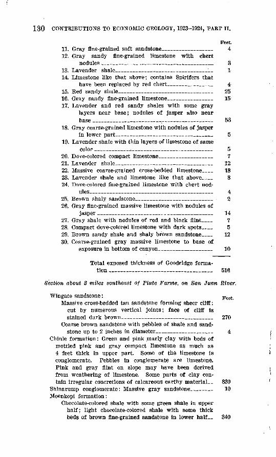
130 CONTRIBUTIONS TO ECONOMIC GEOLOGY, 1923-1924, PAttT II.
Feet11. Gray fine-grained soft sandstone ______ 412. Gray sandy fine-grained limestone with chert
nodules _________________ .__________ 313. Lavender shale____ _ __________ 114. Limestone like that above; contains Spirifers that
have been replaced by red chert__________ 415. Red sandy shale _____ 2516. Gray sandy fine-grained limestone- ________ 1517. Lavender and red sandy shales with some gray
layers near base; nodules of jasper also near base __ . 53
18. Gray coarse-grained limestone with nodules of jasperin lower part __ _ 5
19. Lavender shale with thin layers of limestone of samecolor _______.___________ ______ 5
20. Dove-colored compact limestone ___________ 721. Lavender shale _____ 1222. Massive coarse-grained cross-bedded limestone__ 1823. Lavender shale and limestone like that above__ 824. Dove-colored fine-grained limestone with chert nod
ules__________ ____ 425. Brown shaly sandstone_________________ 226. Gray fine-grained massive limestone with nodules of
jasper ____________ ______________ 1427. Gray shale with nodules of red and black flint__ 728. Compact dove-colored limestone with dark spots__ 529. Brown sandy shale and shaly brown sandstone__ 1230. Coarse-grained gray massive limestone to base of
exposure in bottom of canyon______________ 10
Total exposed thickness of Goodridge forma tion _ _____ 516
Section about 8 miles southeast of Piute Farms, on San Juan River.
Wingate sandstone: Feet Massive cross-bedded tan sandstone forming sheer cliff;
cut by numerous vertical joints; face of cliff is stained dark brown________ ____________ 270
Coarse brown sandstone with pebbles of shale and sand stone up to 2 inches in diameter ______ 4
Chinle formation: Green and pink marly clay with beds of mottled pink and gray compact limestone as much as 4 feet thick in upper part. Some of the limestone is conglomerate. Pebbles in conglomerate are limestone. Pink and gray flint on slope may have been derived from weathering of limestone. Some parts of clay con tain irregular concretions of calcareous earthy material 830
Shinarump conglomerate: Massive gray sandstone __ 10 Moenkopi formation:
Chocolate-colored shale with some green shale in upper half; light chocolate-colored shale with some thick beds of brown fine-grained sandstone in lower half__ 340
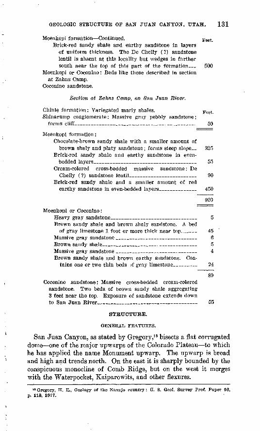
GEOLOGIC STRUCTURE OF SAN JUAN CANYON, UTAH. 131
Moenkopi formation Continued. Feet Brick-red sandy shale and earthy sandstone in layers
of uniform thickness. The De Chelly (?) sandstone lentil is absent at this locality but wedges in farther south near the top of this part of the formation_ 500
Moenkopi or Coconino: Beds like those described in sectionat Zahns Camp.
Coconino sandstone.
Section at Zahns Camp, on Sim Juan River.
Chinle formation: Variegated marly shales. Feet Shinarump conglomerate: Massive gray pebbly sandstone;
forms cliff______________________________ 50
Moenkopi formation:Chocolate-brown sandy shale with a smaller amount of
brown shaly and platy sandstone; forms steep slope__ 325Brick-red sandy shale and earthy sandstone in even-
bedded layers________________________ 55Cream-colored cross-bedded massive sandstone: De
Chelly (?) sandstone lentil________________ 90Brick-red sandy shale and a smaller amount of red
earthy sandstone in even-bedded layers________ 450
920
Moenkopi or Coconino:Heavy gray sandstone____________________ 5 Brown sandy shale and brown shaly sandstone. A bed
of gray limestone 1 foot or more thick near top___ 45 Massive gray sandstone ______________ ____ 6 Brown sandy shale______________________ 5 Massive gray sandstone __________________ 4 Brown sandy shale and brown earthy sandstone. Con
tains one or two thin beds if gray limestone _ 24
89Coconino sandstone: Massive cross-bedded cream-colored
sandstone. Two beds of brown sandy shale aggregating 3 feet near the top. Exposure of sandstone extends down to San Juan River______________ 55
STRUCTURE.
GENERAL FEATURES.
San Juan Canyon, as stated by Gregory,13 bisects a flat corrugated dome one of the major upwarps of the Colorado Plateau to which he has applied the name Monument upwarp. The upwarp is broad and high and trends north. On the east it is sharply bounded by the conspicuous monocline of Comb Kidge, but on the west it merges with the Waterpocket, Kaiparowits, and other flexures.
18 Gregory, H. E., Geology of the Navajo country: U. S. Geol. Survey Prof. Paper 93, p, 113, 1917.

132 CONTRIBUTIONS TO ECONOMIC GEOLOGY, 1923-1924. PART II.
The youngest formation involved, the Navajo sandstone, of Juras sic age, lies on the summits of the Clay Hills 3,000 feet higher than it does at the mouth of the San Juan and 2,000 feet higher than it does at the east base of Comb Eidge. The oldest beds exposed are in the Goodridge formation, of Pennsylvanian age, which reaches the sur face not only in San Juan Canyon near Goodridge but also farther north in the upwarp in Cataract Canyon of the Colorado. The Cre taceous strata that formerly covered the dome have been stripped back to Black Mesa on the south, to Bluff on the east, and to points beyond the Colorado on the west; Tertiary sediments may also have been present.
The strata along and inside the margins of the upwarp usually have dips of 1° to 5°, and higher dips are exceptional, though they are common along the Comb monocline. Large areas of practically horizontal rocks underlie Wilson Mesa and also a belt of country between Piute and Wilson creeks.
Within the Monument upwarp there are several minor flexures, which include anticlines and synclines more than 20 miles in length. The folds and also the few faults that occur along and near San Juan Canyon are described in the following paragraphs. The Comb monocline is in reality a part of the east slope of the Monument upwarp, which is also described here.
The geologic map (PI. XV) shows the axes of the several anti clines and synclines described in this report, and the relative dips of the flanks of the folds are indicated by dip observations. The reader should recognize, however, that the mapping was done by recon naissance methods, which did not permit precise determinations of location in all parts of the area, and therefore detailed geologic work may show that the anticlinal and synclinal axes should, in some areas, be mapped a little to one side or the other of their positions given on Plate XV. Furthermore, there was not time to study the detail of folding and to determine the parts of the anticlines that appear most likely to have caused oil to accumulate. It follows that any prospect drilling on these anticlines should be preceded by geologic work suf ficiently refined to permit making an accurate map showing details of structure by means of structure contours and thus to select parts of the anticlines where local doming, transverse faulting, or other modi fication of the broader structure will add to the chances of success.
FOLDS.
Comb monocline. The Comb monocline extends the whole length of Comb Ridge from Kayenta, Ariz., northward to and beyond San Juan River to the east base of Elk Ridge, a distance of about 100 miles. The strata involved in the monocline range in age from Pennsylvanian to Jurassic and are inclined at angles of 10° to 58°

GEOLOGIC STRUCTURE OF SAN JUAN CANYON, UTAH. 133
E. within the area here described. (See PI. XVI, A.) The up turned edges of the Wingate, Todilto (?), and Navajo sandstones produce the conspicuous saw-toothed Comb Ridge, which is impass able, except at few places. The ridge is a cuesta with a steep west slope and gentle east slope and resembles in appearance " The Reefs " along the east margin of the San Rafael Swell; the same strata are involved in both.
RapUe anticline. West of Comb Wash and the mouth of Chinle Creek the resistant beds of the Goodridge formation rise westward at angles of 15° to 30°. (See PL XVI, A.) Farther west the strata flatten out and not only form the crest of a structural dome but also a topographic dome, which is bisected by San Juan Canyon. To this dome the name Raplee anticline is applied.
The strata descend westward from this dome with dips as great as those on the east side and pass beneath the Supai (?) formation, occupying the Mexican Hat syncline. (See PI. XVI, B.) The anti cline trends N. 25° E., is 15 miles long, and at the widest place is 5 to 6 miles wide. Its highest part crosses the canyon at the Soda Basin, where 1,000 feet of the Goodridge formation is exposed. The anticline is not a single fold but has three axes, all trending nearly north in an en echelon arrangement. One of the axes crosses the canyon in Soda Basin, and another at a point 1 -mile east of The Narrows. The third axis, which is indicated by the dip symbols on Woodruff's geologic map, lies farther northeast and does not cross the canyon.
Mitten Butte anticline. The Mitten Butte anticline is not only the highest but also the widest anticline of the region. Its crest crosses the canyon at Honaker trail, where 1,338 feet of flat-lying beds of the Goodridge formation are revealed. (See PL XVII, B.) Toward the east the beds of this formation are inclined at angles of £° to 6° and pass under the Supai (?) formation in the Mexican Hat syncline. The youngest beds on the crest of the anticline are the Supai (?) formation and Coconino sandstone. They and the Good ridge formation have a westerly inclination of 1° to 4° between Honaker trail and Moonlight Creek, where they flatten out. Owing to this westerly dip the Goodridge formation passes below the level of the river near the mouth of Grand Gulch, and the Supai (?) formation also passes below the level of the river a few miles farther southwest, at the mouth of Buckhorn Canyon. Below this canyon the cliffs of Coconino sandstone rise sheer from the water's edge for a distance of several miles. The full extent of the anticline to the north has not been determined, but to the southwest it passes through the broad Monument Valley, where according to Gregory 14 the loftiest buttes, including Mitten Butte, occur on its crest.
14 Op. cit, p. 114. ^

134 CONTBIBUTIONS TO ECONOMIC GEOLOGY, 1923-1924, PAKT II.
Mexican Hat syncline. The Mexican Hat syncline is a shallow fold lying parallel with and between the Raplee and Mitten Butte anticlines. It trends north, the axis passing through a point 1 mile east of Mexican Hat butte. (See PL XVI, B.} The undifferen- tiated beds of the Supai (?), Cononino, and Moenkopi formations lie in the synclinal trough and extend below the river in the bottom of the trough. The producing wells of the San Juan oil field are from 1 to 3 miles west of the deepest part of the trough and may therefore be said to be well up on the flank of the syncline,
Organ Rock (mticline. The Organ Eock anticline, on whose crest the beautiful 'Organ Rock stands, is a terrace-like fold on the west slope of the Monument upwarp. It trends N. 10° E. from Organ Rock, crossing the San Juan and apparently fading out in the vi cinity of Clay Hill Pass, but south of Organ Rock it falls off rather abruptly, the strata being inclined several degrees. Its length is apparently at least 25 miles. No observation was made to deter mine whether or not the crest is level north of Organ Rock, though if it is not level it is nearly so. The Coconino sandstone, which is the preponderant rock along the anticline in the area under discus sion, lies in a horizontal position along the axis, though Organ Rock, an erosion remnant of red beds of the Moenkopi formation, stands in a narrow, shallow syncline whose sides dip 1° toward the rock. On the east side of the anticline the Coconino sandstone is inclined 3° and passes under the synclinal valley of Moonlight Creek; on the west side the sandstone dips 1° to 3^° and passes below the younger rocks in the Clay Hills and in other mesas farther south. These younger rocks, ranging from the Moenkopi up to the Navajo sand stone, dip west at the same angles as the Coconino. They are trenched by San Juan Canyon between Piute Farms and Zahns Camp, but at the latter place the Coconino again comes to light in the Balance Rock anticline.
Moonlight syncline. The Moonlight syncline lies between and parallel with the Organ Rock and Mitten Butte anticlines and passes northward down the valley of Moonlight Creek, thence across the canyon and to a point a few miles south of Red House, beyond which it is either not present or not conspicuous enough to attract atten tion. The Coconino sandstone, which is the surface rock in the syncline, is inclined at angles of 1° to 4° on both flanks, yet the width of the flanks to the crests of the adjoining anticlines is dis similar, the east flank being 15 to 16 miles wide and the west flank 2 to 5 miles wide. Train Rock and other picturesque erosion remnants farther south rise above a floor of Coconino and Moenkopi beds in the syncline.
Balance Rock anticline. The Balance Rock anticline, so named from Balance Rock, which is larger than a railroad box car, is an

GEOLOGIC STRUCTURE OF SAN JUAN CANYON, UTAH. 135
asymmetrical fold. The crest of the anticline trends north, cross ing the San Juan near Zahns Camp, but at a point a few miles north of the river it bends to the north west, and may cross the Colorado near the " bedrock dam site " and finally join the Waterpocket fold beyond the Colorado. The highest part of the crest apparently lies just north of the San Juan Canyon. (See Pis. XIX and XX, A.)
At Zahns Camp San Juan Canyon cuts squarely across the fold, and in consequence the canyon walls, 2,500 feet high, reveal a re markable section and landscape view of arched rocks of diverse colors and topographic expression. (See PI. XIX, A.) The rock formations here exposed in section are as follows, beginning with the youngest:
Navajo sandstone; forms cap rock on part of high mesa north of river.
Todilto (?) formation; about 200 feet thick, reddish brown; forms rim of canyon wall.
Wingate sandstone; 300 to 400 feet thick; forms reddish-brown impassable palisade-like wall.
Chinle formation; about 850 feet thick; forms badland slopes that reveal patches of variegated marly shale of the Chinle under neath coarse sandstone dSbris from superjacent cliffs.
Shinarump conglomerate; about 50 feet thick; forms gray cliff and platform.
Moenkopi formation; 920 feet thick; forms fluted cliffs, bad- land slopes, and spurs, and also floors most of basin in which Zahns Camp is situated. The De Chelly (?) sandstone lentil, 90 feet thick, forms prominent creamy band along faces of red cliffs.
Coconino sandstone; forms inner canyon with gray precipitous walls 144 feet high just east of Zahn,s Camp and also floors part of basin.
The strata involved in the anticline are all parallel and thus have the same dips at any particular locality. Along the wide west slope, which extends beyond Piute Creek and the Great Bend, the dips are low, ranging from 5° to less than 1°, but along the steep narrow east slope they range from 13° to 25°. Toward the northwest the dips of the east slope decrease to a few degrees before Colorado River is reached.
The east slope of the anticline is in reality an eastward-facing monocline resembling the Comb monocline, although not so steep. It is apparently a northward extension of the Hoskinnini monocline, which has been described by Gregory.15
/Spring syncttne. At the east base of the monocline just described there is a parallel syncline, though the trough or axis in passing down Spring Gulch swings southeastward across the San Juan.
15 Gregory, H. E.. Geology of the Navajo country: U. S. Geol. Surrey Prof. Paper 93, p. 114, 1917.

136 CONTRIBUTIONS TO ECONOMIC GEOLOGY, 1923-1924, PAST II0
In the trough the badland slopes of the Chinle formation touch the river, and on each side of it the resistant Shinarump conglom erate in rising above the river produces an inner canyon with verti cal walls. The youngest rocks in the syncline are the Wingate, Todilto (?), and Navajo formations, which cap the high mesas on either side of the river. The extent of the syncline away from the river has not been determined, though it probably crosses the Colorado and adjoins the northeast side of the Waterpocket fold.
Navajo Mountain anticline. A. domelike anticline, whose crest is in Navajo Mountain extends northward across the San Juan near the Thirteen-foot Eapid. It may join the south end of the main axis of the Waterpocket fold, but the apparent synclinal structure of the flat-topped Wilson Mesa, as noted in distant views, suggests that the Navajo Mountain anticline dies out a few miles north of the San Juan. The canyon of the San Juan in trenching the anticline ex poses 700 feet of the upper part of the Chinle formation, which is the surface formation in the open country below Wilson Creek.
This anticline, like the others in the region, has a steep, short east slope and a long, gentle west slope, which extends to and beyond the mouth of the San Juan. The Wingate, Todilto (?), and Navajo formations, which occur not only on the slopes but on the crest of the anticline, are inclined at angles of 8° to 10° on the east slope and 2° to 5° on the west slope, though one dip of 7° was measured on the west slope a few miles south of the river. (See PL XX, B.)
The upbowing of the strata in Navajo Mountain is attributed by Gregory 16 to the presence of a laccolith of igneous rocks far beneath the surface. The domelike form of the crest of the anticline, the unusual bleaching of the Navajo sandstone in the mountain, and the proximity of the Henry and other mountains of laccolithic origin give weight to this suggestion, notwithstanding the fact that no igneous rocks have been discovered thus far in the vicinity of the mountain. But the northward trend of the anticline across San Juan Canyon, roughly parallel with the trend of the other folds here described, suggests that the part of the anticline at and near the canyon may have been produced in the same way as the other folds. Crustal .warping or folding, without the aid of igneous activity, was probably the cause of the long folds so characteristic of the region under discussion.
Waterpocket fold.17 The Waterpocket fold is a long asymmetrical anticline extending in a general northwesterly direction from the vicinity of the Rincon, on Colorado River, and increasing in height toward the Circle Cliffs, which are on its summit.
10 Op. cit, p. 11, pi. 22.17 The information here presented about this fold has been obtained mostly from W. R.
Chenoweth and R. C. Moore.

GEOLOGIC STRUCTURE OF SAN JUAN CANYON, UTAH. 137
The cliffs of the canyon of the Colorado, which trenches the south east end of the anticline, reveal the following rock formations from the base to the top of the cliffs: Moenkopi formation, Shinarump conglomerate, Chinle formation, Wingate sandstone, T'odilto (?) formation, and Navajo sandstone. All these strata are inclined at low angles away from the anticlinal axis, which passes through the Eincon in an apparently southward direction. The anticline, for reasons previously given, appears to die out a few miles south of the river and not to join the Navajo Mountain anticline. The westward slope of the anticline continues to and beyond the mouth of Escalante River.
Rapid syncline. The Rapid syncline, so named from a small rapid at the locality where its axis crosses the San Juan, lies be tween and parallel with the Navajo Mountain and Balance Rock anticlines, near the former. The rocks along its trough are hori zontal; the Chinle formation, the oldest, extends to a height of 20 feet on the canyon walls. Southward along the axis of the syncline the beds rise slightly, indicating that the deepest part of the syn cline is to the north. The southern extension of the syncline is not known, but it doubtless passes along the east base of Navajo Moun tain. To the north the syncline apparently merges with the Wilson syncline.
Wilson synclwe. The Wilson syncline, whose limits are poorly known, is apparently coextensive with the flat-topped grass-carpeted Wilson Mesa, which has an east-northeast trend. The regional dip in and near the Great Bend is 2°-2^° NW. South and southeast dips in the vicinity of the Rincon were observed from an elevated point several miles north of Zahns Camp. The mesa, whose summit passes within 1 or 2 miles of the west end of the Great Bend, is floored by the Navajo sandstone. The southern part of the summit is slightly tilted toward the north and the northern part of the summit is slightly tilted toward the south, so that the summit is in reality an extremely shallow east-west trough. The surface of the mesa from a distant point of observation appeared to lie parallel with the bedding of the Navajo sandstone. The writer did not have opportunity to ascend the mesa itself. There appear to be three routes to it one leading eastward from the Hole in the Rock, another northward up Wilson Creek, and another southwestward from the Clay Hill Pass.
FAULTS.
Although faults can be readily detected and traced continuously in this region of naked rocks, a surprisingly small number were found. The few faults, most of which are here briefly described, include nor mal faults and also thrust faults, notwithstanding the fact that fold ing has only slightly warped the strata.

138 CONTRIBUTIONS TO ECONOMIC GEOLOGY, 1923-1024, PART II.
A crooked fault, If miles long, described by Woodruff,18 is present 5 miles southeast of Goodridge. The vertical displacement of the beds ranges from 20 to 200 feet, and the upthrow is on the west side. The character of the fault, according to Woodruff, is not clearly dis played but he believed it to be of the thrust type.
Four close parallel faults with a southeastward trend cut the Goodridge formation vertically in the southern part of " The Goose necks." The northernmost fault shows as a prominent break that is marked on the southeast canyon wall by a narrow, inaccessible gulch. The character of the displacement, whether horizontal or vertical, could not be determined, though if it is vertical it does not exceed 1 to 2 feet. The next fault to the south, some 250 to 300 feet away, has a downthrow of 6 inches on the northeast side. Its course is followed by two short gulches, one on either side of the river. The third fault, which is 250 to 300 feet farther downstream, does not appear to have a vertical displacement, but horizontal slickensides displayed on the northeast fault face on the north side of the river indicate that the displacement has been in a horizontal direction. The fourth fault, 250 feet farther south, has been produced by hori zontal movement, as is shown by horizontal slickensides on the south^ west fault face on the south side of the river.
Two parallel thrust faults about a quarter of a mile apart cut the flat-lying beds of the Goodridge formation in the canyon southwest of Cedar Point. The fault planes of both apparently trend north. They dip 15° to 20° E., and the displaced beds have been thrust westward with a vertical displacement of 2-| to 3 feet. The west fault does not appear to extend up the north canyon wall more than 50 feet above the river, and it was not visible in the south canyon wall. The occurrence of slickensides with a trend of N. 25° W. in stead of west indicates that the rocks along the fault were displaced horizontally as well as vertically.
A thrust fault that cuts beds of nearly horizontal cherty lime stone in the Goodridge formation is displayed in the north canyon wall at a point 3 miles below the mouth of Johns Canyon. The fault plane dips 10° upstream, and the upthrust as indicated by a broken chert layer is 2 inches. This fault extends to the top of the cliff of limestone 50 feet high but dies out in the lower part of the overlying shale. It does not occur on the south side of the river.
A normal fault with a northeasterly trend crosses the river three- quarters of a mile south of the mouth of Slickhorn Gulch. At its observed exposures, which are on both sides of the river, it cuts the beds of the Goodridge formation, which have a westerly dip of 2°. The fault plane is vertical, and the downthrow, which is on the
18 Woodruff, E. G., Geology of the San Juan oil field, Utah : U. S. Geol. Survey Bull. 471, pp. 92-93, 1912.

GEOLOGIC STRUCTURE OP SAET JUAN CANYO'N, UTAH. 139
southeast side, is 4 feet. The oil that issues at the numerous seeps nearby may ascend along the fault plane before it flows to the sur face through the loose detrital material on the canyon floor.
A normal fault running north across the river cuts the flat-lying Coconino sandstone on the crest of the Organ Rock anticline, 1$ miles northwest of the mouth of Moonlight Creek. The fault plane dips 75° E., and the downthrow, which is on the east side, is 10 feet or mofe.
A normal fault, which was traced in a northeastward direction for a distance of 1 mile, occurs 2| miles southeast of Piute Farms. It cuts the Coconino sandstone, which dips about 3° W., and is marked by a narrow crushed zone with vertical breaks. The down throw as observed at the northeast is 8 feet on the west side, but any displacement that may occur farther south could not be determined.
A normal fault with a displacement of 5£ feet and a trend of N. 20° W. cuts the flat-lying Wingate and Chinle formations in the first southern tributary canyon above Wilson Creek. In reality it consists of two parallel faults 5 feet apart, both of which cut the rocks vertically. The east fault has a downthrow of 4| feet on the west side, and the west fault a downthrow of 1 foot also on the west side.
A northwestward-trending normal fault follows a bench along the east side of the canyon of Wilson Creek. (See PL XX, B.) The bench is floored by the resistant sandstone beds of the Todilto (?) formation; and side canyons trenching it reveal the underlying Wingate sandstone. The fault cuts these formations on the east slope of the Navajo Mountain anticline. The displacement has not only lowered the rocks on the west side from a minimum of a few feet to a maximum of 60 feet, but has produced a westward-facing fault scarp whose height is the same as the amount of downthrow.
A series of parallel faults with a trend of N. 60° W. is revealed in the east canyon wall of the Colorado opposite the Hole in the E-ock. The strata involved are the sandstone beds of the Wingate and Todilto (?) formations, which dip 2° to 3° W. The northernmost fault, whose plane dips 55° S., has a downthrow of about 50 feet on the south side. Gregory 19 states that it passes through Hole in the Rock, which is a narrow vertical crack in a wall of Navajo sandstone some 600 to 800 feet high. This crack, which is the only one in the impassable canyon wall for many miles, was utilized by the San Juan mission party for the building of a roadway in the winter of 1879-80, so that they could descend to and cross the Colorado. The middle fault, which is about 100 feet south of the north fault, has a downthrow of 10 feet on the north side. The fault plane dips at a
19 Oral communication.
101374° 25 10

140 CONTRIBUTIONS TO ECONOMIC GEOLOGY, 1923-1924, PART II.
very high angle. The south fault, which is about 100 yards farther downstream, has a downthrow of 10 feet on the south side. Its plane stands vertical.
PETROLEUM.
OIL SEEPS.
Several oil seeps deriving their oil from the Goodridge formation occur in the bottom of San Juan Canyon between Mexican Hat and the mouth of Slickhorn Gulch. The largest of these is a rather con tinuous series of seeps extending for a distance of 1£ miles up the can yon from the mouth of the gulch. (See PI. XVIII, B.) The seeps were observed on the right bank of the river; the left bank was not visited. The oil comes up as bubbles in the water and as minute streams through sand and also through boulders of sandstone and limestone at the edge of the water. The boulders, which have fallen from the adjacent cliffs, are cut by cracks through which the oil passes. The drops of it on reaching the surface of the river break and spread as thin iridescent films. The oil is a brown liquid that flows easily, and although its odor is strong the odor of gasoline is not noticeable. A black asphaltic residue cements rather large patches of sand and rock fragments. At one seep a film of oil cover ing several square feet of a sand bar is used by flies as a breeding place, and hundreds of larvae live in the oily substance on the bare surface of the sand bar, in spite of the intensely hot rays of a sum mer's sun which beat down on them during the day. Westward- dipping beds of the Goodridge formation, which form the lower canyon walls near the seeps, are cut by a normal fault with a north eastward trend and a downthrow of 4 feet on the east side. Its presence suggests that the oil ascends along the fault plane to the alluvial material, through which it passes to the surface.
Seeps are reported in Johns Canyon about 2 miles above its mouth.About \\ miles southeast of the head of Honaker trail minute
trickles of oil and gas issue from a sand bar in the edge of the river. A chip saturated with the oil was set on fire. Gasoline, as indi cated by its strong odor in this part of the canyon, forms a consider able part of the crude petroleum.
A seep is reported to occur on the right bank of the river in or near the Second Narrows.
The " Goodridge " oil sand, which forms a gorge and a superjacent bench at the Goodridge Bridge, contains small dark areas of oil along its joints and cracks for a distance of 200 feet along the river east of the bridge. (See PL XVII, A.) The restriction of the oil showings to the cracks and joints in the sandstone indicates that the sandstone .is not uniformly porous. The sandstone, which is here 27 feet thick, dips 2° E.

GEOLOGIC STRUCTUBE OF SAN JUAN CANYON, UTAH. 141
The " Goodridge" oil sand also contains showings of oil on the right bank of the San Juan half a mile northeast of the village of Mexican Hat. Some blasting has been done here recently in order to make a pit in which, it was hoped, oil would accumulate. At the time of visit (1921) the pit was shallow and no oil had run into it.
A seepage of brown oil,20 not visited by the writer, issues from the Shinarump conglomerate on the right bank of the Colorado opposite the Kincon. The oil spring is on the west flank and near the crest of the Waterpocket fold, which here plunges toward the south.
Numerous small seeps of gas, probably marsh gas, were observed by the writer along the east bank of Colorado Kiver between the Hole in the Kock and the mouth of the San Juan. The seeps occupied the bottoms of funnel-shaped craters as much as 3 feet in diameter and more than 1 foot deep in the clayey alluvial material that is common along the river. Some of the craters were slightly submerged, others were partly filled with water, and others stood high enough above the river to be dry. They were obviously formed under water whose slow currents carried away the silt that was being agitated by the gas. The gas is not sufficient in any of the craters to produce a stream, but that issuing through water forms a continuous succession of bubbles whose escaping gas will burn for several seconds. The flame of the burning gas is almost colorless, though it has a slight bluish cast. The gas is almost certainly marsh gas that is derived from decaying vegetal matter which is buried in the clayey alluvium in this part of Glen Canyon. The Colorado here flows with a rather slow current, and it deposits not only much fine mud but also considerable vegetal matter. The alluvial material flooring the canyon is perhaps 80 feet deep. Seepages of marsh gas along the Colorado near Moab, Utah, have been described by Woodruff.21
No seepages of gas similar to those just described occur along the San Juan, because the finer alluvial material, consisting almost en tirely of sand, would not permit the accumulation of sufficient quan tities of marsh gas to produce seeps.
DEVELOPMENT.
Of the early development in the San Juan region Woodruff 22 says:
Though oil springs must have been seen by prospectors and traders who operated along San Juan River, they seem to have received only casual notice until 1882, when E. L. Goodridffe made the first location of a claim. No drilling was done, however, until the fall of 1907, when the first well, Crossing
20 Information, supplied by W. R. Chenoweth.. and R. C. Moore.21 Woodruff, E. G., Marah gas along Grand River near Moab, Utah: U. S. Geol. Survey
Bull. 471, p. 105, 1912.22 Woodruff. E. G., Geology of the San Juan oil field, Utah: U. S. Geol. Survey Bull.
471, pp. 98-99, 1912.

142 CONTRIBUTIONS TO ECONOMIC GEOLOGY, 1923-1924, PART It.
No. 1, was begun. This well encountered oil March 4, 1908, at a depth of 225 feet. It was a gusher, throwing oil to a height of 70 feet above the floor of the derrick, and led to considerable excitement. Other wells followed in rapid succession in 1908 and 1909, but most of them were only prospect holes put down to validate the titles to claims and not with serious intention of de-; termining the oil resources of the field. By the summer of 1910 considerable capital had been enlisted to exploit the field. One standard rig was in opera tion, and others were reported to have been ordered. There were 10 portable deep-well rigs in the area and several more on the way to it. During mid summer active development was somewhat retarded on account of the heat, but in the later part of August preparations were made to renew operations with greater vigor than before. Reports received from reliable sources during the winter of 1910-11 indicate that the expectation of activity has been fully realized. On February 1, 1911, according to a report by A. L. Raplee, there were 27 drilling rigs in the field and equipment for more on the way. Two oil wells were brought in during the winter and there was considerable improve ment at old wells. A small town had been established near Mexican Hat and the roads and general facilities much improved.
A period of comparatively little activity in drilling began about 1911 and has continued until the present time (May, 1923), though activity has increased to a certain extent within recent years on account of the stimulus resulting from the successful completion of the Mexican Hat well in 1922.
The operations in May, 1923, included the following: A well was being drilled near Organ Eock by Wilson Cranmer & Co., of Den ver, Colo.; a well was being drilled near Alhambra Rock by the Monumental Oil Co.; a refinery with a capacity of 150 barrels a day was being operated by Andrew McCormick at the 1922 well of the Mexican Hat Co.; the London San Juan Oil Co. was drilling a well in the NW. \ sec. 13, T. 41 S. 5 R. 18 E,; and shallow wells, drilled merely as assessment work, were bored from time to time on the oil claims. In March, 1924, a well being drilled by the Mid west Refining Co. on Gypsum Creek south of Goodridge had reached a depth of 2,000 feet.
PRODUCTION.
The only notable production has been obtained from a few wells of small individual capacity, near Mexican Hat and Goodridge. These wells, which are named below, are within a radius of 1£ miles of the common corner of sees. 5, 6, 7, and 8, T. 42 S., R. 19 E.:
Hudson well (No. 34 on map).Bryce No. 1 well (No. 36).Bryce No. 2 well (No. 39).Mexican Hat well (No. 41).Crossing No. 1 well (No. 43).Monticello well (No. 44).
Other wells within the same radius have bailed small quantities of oil or furnished showings of oil; and north of that locality showings

GEOLOGIC STRUCTURE OF SAN JUAN CANYON, UTAH. 143
of oil have been reported at various depths from scattered wells in T. 40 S., R. 19 E., and T. 41 S., Rs. 18 and 19 E. Showings of oil are also reported from wells as far west as Johns Canyon and the mouth of Slickhorn Gulch, and from the Gypsum Creek well of the Midwest Refining Co.
The production of the field has all been consumed locally and has been distributed over a period of 15 years beginning in 1908. No reliable estimate of the output of the field in that period is available, though records of sales from the Bryce No. 2 well show that some 5,000 barrels of oil was disposed of for field use in 1910 and 1911, exclusive of many barrels of oil either wasted or consumed in drilling by the owners of that well.
CHARACTER OF THE OIL.23
Samples of the oil were collected from four wells in the oil field and sub mitted to David T. Day, of the United States Geological Survey, under whose direction physical and chemical examinations were made as shown in the following table:
Chemical and physical properties of oil in the San Juan oil field, Utah.
Serial No.
Utah 4.... .
Utah 5.....
Utahe.....
Utah 7.....
Serial No.
Utah 4...... Utah 5...... Utah6......Utah 7......
t
Well No. 4, Goodridge town site; E. L. Goodridge, Goodridge.
Jackson well, sec. 5, T. 42 S., R. 19 E.; stray sand; Monumental Oil Co., Bluff.
Anderson [Hudson] well, sec. 5, T. 42 S., R. 19 E.; Baby or "Goodridge" sand; South Side Oil Co., Mexican Hat.
Arcola well No. 2, T. 42 S., R. 19 E.; Mendenhall sand; Bluff.
Depth (feet).
263
625
300
600
Distillation by Engler's method.
Be gins to
boil CO.).
70 78 73 97
By volume.
To 150° C.
Cubic centi me ters.
12.0 11.0 12.0 10.0
Spe cific
grav ity.
0.7245 .7235 .7130 .7395
150°-300° C.
Cubic centi me ters.
36.0 35.0 36.0 37.0
Spe cific
grav ity.
0. 7941 .7976 .7941 .8021
Residuum.
Cubic centi me ters.
49.3 51.0 49.5 52.0
Spe cific grav ity.
0. 8974 .8946 .8975 .8986
Total (cu bic cen- ti-
me- ters).
99.3 97.0 97.5 99.0
Physical properties.
Gravity.
Spe cific.
0. 8264
.8314
.8202
.8388
Sul phur (per cent).
0.26 .18 .20 .40
Par af fin (per
cent)
6.09 5.29 3.25 6.79
Degrees 3aum6
39.4
38.4
40.7
36.9
As phalt (per cent).
0.80 .60
1.11 .49
Color.
Black.
Do.
Do.
Dark green.
Unsaturated hydro carbons
(per cent).
Crude.
20.4 14.8 14.4 19.2
100°- 300° C.
1.0 6.0 8.0 6.0
23 Woodruff, E. G., op cit., pp. 94-95.

144 CONTRIBUTIONS TO ECONOMIC GEOLOGY, 1923-1924, PART II.
Concerning the character of the oil, Mr. Day further remarks: "These oils, as shown by the analyses, are unusually light in specific
gravity. They yield more than the average amount of gasoline and of burning oil. The light specific gravity of the burning-oil fraction compared to the average, the considerable amount of paraffin wax, and the com paratively low proportion of unsaturated hydrocarbons show that these oils are somewhat similar to the oil from Lima, Ohio, with a smaller proportion of sulphur. In fact, the amount of sulphur is less than in many oils in Illinois, which are refined without special apparatus for eliminating sulphur. Taken altogether, these oils are well suited for the manufacture of gasoline and kerosene, and there is every indication that the residuum would yield valuable lubricating oils."
The oil from the 1922 well of the Mexican Hat Co. is stated to have a gravity of 47° Baume.
DIFFICULTIES OF EXPLORATION.
The difficulties of exploration in this rough arid region, 150 to 200 miles from a railroad, are many. There are few inhabitants, so that most laborers must be imported. All so-called roads west of Bluff and north of Kayenta are poor indeed and at times are im passable for wagons and automobiles. Most parts of the canyon country are not traversed by roads. The rainfall does not exceed about 6 inches a year, so that water for drilling as well as for drinking is scarce and generally has to be hauled or carried long distances. No timber is available for fuel except driftwood along the San Juan and scrub cedar and pinon on Cedar Mesa and other mesas of similar height farther west. The principal fuel for drill ing is oil from the small producing wells in the San Juan oil field. The cost of hauling coal into the region from the vicinity of Monticello, Utah, or from other places is prohibitive.
GEOLOGIC OCCURRENCE OF OIL.
The small producing wells enumerated above are 1 to 2 miles west of the northward-trending axis of the moderately depressed Mexican Hat syncline and penetrate beds that dip 2°-4° E. toward the trough of that fold. The oil showings to the northeast were found in strata of low dip on both flanks of the syncline. The oil showings in Johns Canyon were apparently found on the crest of the Mitten Butte anti cline, and the showings in the well at the mouth of Slickhorn Gulch, where there are numerous oil seeps, are in strata that dip 2° W. on the west flank of the anticline. The fault that cuts the strata at the mouth of the gulch may have influenced the accumulation of the oil by providing a channel for it.
The oil in the San Juan region occurs in the Goodridge formation (Pennsylvanian) which contains ten reported oil-bearing sands, to seven of which names have been given. Five of the sands whose posi-

GEOLOGIC STRUCTURE OF SAN JUAN CANYON, UTAH. 145
tion has been determined by Woodruff in the Honaker trail section are listed in the following table:
Names, position, and thickness of five <oil sands in the San Juan oil field.
Name.
Baby..... ___ .............. _ ....... ____ ."Qoodridge" .....................................Third or No. 3.. ................ .................
Little Loop.. ___ ... __ ... _ ... _ .........
Character.
.....do.................
.....do.................
.....do.................
.....do.................
Number in
Honaker trail sec tion on pages
127-129.
35
1012
Below 17
Depth below top of forma
tion in Honaker
trail section (feet).
3360
178218361
Thick ness
(feet).
2-1212-63 (?)
24-300-3J
A sand called the 10-foot sand was found in the London-San Juan Oil Co.'s No. 3 well, 356 feet deep (well No. 26 on map), and a sand called the Arcola sand was passed through in the Producers well, 800 feet deep (No. 28 on map), The writer does not know the position of these sands in the Goodridge formation. The Honaker sand is re ported to occur just below water level at the foot of the Honaker trail. The " Blue Shale," another oil sand, is said by Woodruff not to be present in the Honaker trail section, but its position as sug gested by him is below bed No. 48. The position of the Amber sand in the geologic section is not known by the writer.
The oil sands, as will be noted in the table, vary in thickness from place to placev At some places the oil saturates the unbroken rock, indicating that such rock is uniformly porous; but at others, as at the seep in the " Goodridge " sand at the Goodridge Bridge, the oil stains are irregularly distributed along joints and other cracks, indi cating that the sandstone is not uniformly porous.
Several wells were drilled no deeper than the Baby sand, but most of them went as far as the " Goodridge," and one is reported to have gone to a depth of 1,900 feet, the entire hole being in the Goodridge formation. The " Goodridge" is reported to be the sole or chief producing sand in the Monticello, Crossing No. 1, and Hudson wells. Oil was encountered in the No. 3 and Mendenhall sands in the Bryce No. 2 well. The oil from the Mexican Hat well comes from the Little Loop sand.
The fact that only a few of the rather large number of wells drilled in the vicinity of Goodridge and Mexican Hat have produced more than meager quantities of oil suggests that the oil in the sands is pockety and that its discovery with the drill is more or less accidental. This suggestion seems to be borne out by the character of one of the principal sands the "Goodridge" as revealed at the Goodridge

146 CONTRIBUTIONS TO ECONOMIC GEOLOGY, 1923-1924, PART II.
Bridge, where oil is not uniformly disseminated through the sand stone but is confined to joints and other cracks.
The deep trenching of the oil field by San Juan Canyon has pro vided a natural drainage outlet for the oil and water above the level of the canyon floor, though the level of the oil and water tables would rise somewhat away from the river. All the few and small springs and the oil seeps are confined to the canyon floor.
POSSIBLE RESULTS OF FURTHER DRILLING.
The Goodridge formation, which contains the oil sands of the San Juan oil field, is not fully exposed in the region under discussion, though 1,338 feet of beds are exposed at the Honaker trail and 1,900 feet of beds are reported to have been passed through in the Gallo way well, in Johns Canyon. The total thickness of the formation and the age of the underlying rocks whether pre-Cambrian or early Paleozoic are not known. The formation is exposed not only in the oil field here named but also in the Cataract Canyon of the Colorado, to the north. Furthermore, equivalent beds have been penetrated in wells in the Circle Cliffs anticline,24 80 miles away in a west-northwest direction; in the San E-afael dome, 115 miles to the north-northwest; and in the McElmo anticline,25 in southwestern Colorado, 60 miles to the east. The lower part of the Supai forma tion of the Grand Canyon, to the southwest, is believed by G. H. Girty to be of the same age as the upper part of the Goodridge, but so far as known the lower part of the Goodridge is not represented in the Grand Canyon section. The Goodridge formation, therefore, probably underlies not only all of the San Juan Canyon country but large adjoining areas. Yet it thins out southward, as is shown by its absence in wells in the De Chelly uplift, in northeastern Ari zona.26 The nearest of these wells to San Juan Canyon is in Nazlini Canyon, 18 miles southeast of Chinle, where the Supai formation rests upon granite probably of pre-Cambrian age.
The Goodridge in Cataract- Canyon, as described orally to the writer by Sidney Paige, is similar to the Goodridge in and near the San Juan oil field, though no oil seeps are- reported from it in that canyon. The equivalent beds in the Circle Cliffs well, which showed no oil, were, according to E. C. Moore, penetrated to a depth of 1,582 feet after the Coconino and Supai formations, 1,548 feet thick, were passed through. The log of the San Rafael well, 3,035 feet deep, which also found no indication of oil, is shown by Heist 27 to be very similar to that of the Circle Cliffs well.
24 U. S. Geol. Survey press notice by R. C. Moore.28 Anticline described in 1921 by Coffin, R, C., Colorado Geol. Survey Bull. 16, 1921. w Oral communication from N. H. Darton.27 Heist, H. D., Geological position of test wells drilled In eastern. Utah, fields: Salt
Lake Min. Rev., vol. 24, No. 1, p. 19, April 15, 1922.

GEOLOGIC STRUCTURE OF SAN JUAN CANYON, UTAH. 147
The Goodridge formation in the Circle Cliffs well consists mainly of white sandstone and white limestone with comparatively little red shale and sandstone, in marked contrast with the red and gray sandy shales and gray limestone of the San Juan oil field. A con spicuous change in the character of the Goodridge therefore takes place between the San Juan oil field and the Circle Cliffs.
In the exposures of the Goodridge between the mouths of Chinle Creek and Grand Gulch the beds of the formation display a re markable uniformity of thickness and character at all places. The character of the formation as revealed east of Grand Gulch probably persists at least as far as the Organ Rock anticline, and it may persist as far as the Balance Rock and Navajo Mountain anti clines. The formation can therefore confidently be expected to be oil-bearing to and beyond the Organ Kock anticline, in spite of the fact that it contains no oil in the Circle Cliffs and the San Rafael Swell.
The small production of the San Juan oil field has come from the Goodridge formation in the Mexican Hat syncline, but on ac count of the extensive prospecting, the small production, and the deep trenching of the oil field by San Juan Canyon, only small flowing wells and perhaps fairly good pumping wells may be ex pected in the prospected sands within the limits of the present field. No large producing wells may be expected in the field unless they are discovered by drilling deeper into the Goodridge, whose entire thickness is not known, or by drilling in adjoining areas.
Questions naturally arise concerning the possibilities of oil in not only the Goodridge but other rocks in the anticlines of the region and also in the several synclines near by. If the rocks in the anticlines are saturated with water the oil they may contain would be looked for with confidence on the anticlinal crests. As there is this possi bility of water saturation, especially below the level of the canyon floor, it would appear advisable to prospect the anticlines first.
However, the failure to discover more than showings of oil in the Galloway well, 1,900 feet deep, on the Mitten Butte anticline and in the McElmo well, 4,588 feet deep, on the McElmo anticline where the equivalent beds of the Goodridge are apparently similar to those of the Goodridge in the San Juan oil field appears to militate against the discovery of commercial quantities of oil in the Good ridge in the anticlines of the San Juan Canyon country. The Mc Elmo well, which was drilled in 1921 and 1922 in the NE. i sec. 23, T. 36 N., R. 18 W., in Montezuma County, Colo., penetrated the Hermosa formation (equivalent to the lower part of the Goodridge formation) to a depth of 1,736 feet after passing through 2,852 feet of red beds of the Dolores and Cutler formations. The Cutler and Dolores perhaps contain beds that are equivalent to the Supai (?),

148 CONTRIBUTIONS TO ECONOMIC GEOLOGY, 1923-1924, PART II.
Coconino, Moenkopi, Shinarump, and Chinle formations of the San Juan Canyon country.
Furthermore, the failure thus far to discover more than a small amount of oil in beds younger than the Goodridge on the McElmo anticline and the total dryness of the beds in the anticline near Caineville, Utah, discourage the hope that oil will be yielded by the rocks overlying the Goodridge in the Navajo Mountain anticline. Yet a well being drilled (April, 1924) by the Southwest Oil Co. in T. 43 S., R. 23 E., about 25 miles southeast of Goodridge is reported to have encountered at a depth of 1,565 feet some oil in a sand said to be the Shinarump conglomerate. Also in Washington County, in southwestern Utah, small quantities of oil have been found in the Moenkopi formation,28 and oil seepages are numerous in the Moenkopi in Utah, especially west of Colorado River.29 The well near Caineville, 3,035 feet deep, which was drilled by the Ohio Oil Co., started in the lower part of the McElmo formation,80 passed through several formations, including the Navajo, Wingate, Chinle, Shinarump, and Moenkopi, and stopped in the top of a sandstone that is probably the Coconino sandstone.
A well drilled recently by the Utah Oil Refining Co. on the Farnham anticline,31 near Price, Utah, to the north, struck a large flow of gas composed of carbon dioxide, nitrogen, and minor other constituents.32 The well, which is 3,100 feet deep, is presumed to have reached the lower part of the Moenkopi formation.32
The producing sands of the recent oil wells 18 miles west of Farm- ington, N. Mex., a recent well near Shiprock, and the gas wells 15 miles north of Farmington appear to be in beds of Upper Cretaceous age.
The Raplee anticline has not been penetrated with a drill, per haps for the reason that there are few or no practicable drilling sites on it. To drill in the canyon on one or more of the crests of the anticline would require enormous expense in blasting a roadway in the face of the canyon walls, or in constructing a tramway, and to drill on the rim of the canyon would require not only deep drilling but the hauling of water for long distances.
The Mitten Butte anticline has been prospected by the Galloway well, 1,900 feet deep, in Johns Canyon, and the Hulkito well, 1,200 to 1,300 feet or more deep, south of the river; and it is now being
28 Bossier, Harvey, and Reeside, J. B., Oil prospects in Washington County, Utah, : U. S. Geol. Survey Bull. 726,, pp. 87-107, 1922.
» Ball, M. W., Am. Assoc. Petroleum Geologists Bull., vol. 6, No. 3, p. 225, 1922. 30 Letter from W. B. Calvert.81 Clark, F. R., The Farnham anticline, Carbon County, Utah: U. S. Geol. Survey Bull.
711, pp. 1-13, 1920.82 Calvert, W. R., Gas at Famhamj, Utah: Am. Assoc. Petroleum Geologists Bull., vol. 7,
No. 3, pp. 293-295, 1923.
GEOLOGIC STRUCTURE OF SAN JUAN CANYON, UTAH. 149
drilled near Alhambra Eock by the Monumental Oil Co., which plans to go to a depth of 3,000 feet. The Galloway well, which is said to have started on the top of the Goodridge formation, probably penetrated beds that lie as much as 500 to 600 feet below the beds exposed at the foot of the Honaker trail, but the rocks in it are said to have been dry below a depth of 100 feet. The 3,000-foot well of the Monumental Oil Co. near Alhambra Rock, which was probably started on or near the top of the Goodridge, will pene trate beds that lie about 1,600 feet below those exposed at the foot of the Honaker trail.
In the Organ Rock anticline the Goodridge formation does not come to the surface. The Goodridge is overlain by the Supai (?) formation, 380 feet thick, and the Coconino sandstone, 600 feet thick, but along the river the canyon has trenched the anticline to a depth of some 400 to 600 feet. If the Goodridge is saturated with water there is therefore a possibility that its topmost beds as well as lower beds might contain oil. A well is now (March, 1924) being drilled on the anticline a few miles south of Organ Rock by Wilson Cranmer & Co., of Denver, Colo. The well, which is reported to have reached a depth of 2,600 feet, started on the top of the Coconino sandstone, then passed through this sandstone into the Supai (?) formation, and next entered the Goodridge formation at a depth reported to be 965 feet.
The Coconino sandstone is also the oldest formation exposed on the crest of the Balance Rock anticline, which crosses the canyon at Zahns Camp. The Goodridge formation, which doubtless occurs in the anticline, is buried beneath the Supai (?) and Conconino formations, whose combined thickness are probably about 1,000 feet. This anticline has not been tested with a drill.
The Navajo Mountain anticline, the last and also the most in accessible anticline found along the San Juan, crosses the river near Wilson Creek and the Thirteen-foot Rapid. The oldest forma tion exposed on its crest is the Chinle formation, of which 700 feet of the upper part is revealed in the canyon walls between the above- named creek and rapid. The following formations with their pos sible thicknesses doubtless occur below the level of the canyon floor: Chinle, 150 feet; Shinarump, 50 feet; Moenkopi, 920 feet; Coconino, 600 feet; Supai (?), 380 feet; Goodridge formation, probably many hundred feet. These figures mean that the Shinarump conglomerate, from which oil issues as a seep on Colorado River opposite the Rincon, is a possible oil sand on the Navajo anticline; but the rather thin cover of Chinle perhaps 150 feet thick, which may really be re duced to half this figure by the alluvial fill under the bed of the rjver may not be sufficient to keep oil from passing out of the conglomerate into the bottom of the canyon. Furthermore, the

150 CONTRIBUTIONS TO ECONOMIC GEOLOGY, 1923-1924, PART II.
enormous landslides involving the Chinle at this as well as at other localities may have disturbed the Chinle below the river bed down to the Shinarump. If so, there would be additional opportunity for the upward escape of oil through such disturbed beds. The lenticular De Chelly sandstone, which occurs in the middle of the Moenkopi red beds over large areas in southeastern Utah, may also occur at this locality. If so, it probably lies at a depth of about 600 feet below the river. The top of the Goodridge, as indicated by the above figures, lies at a depth of 2,100 feet below the river on the crest of the anticline.
The Big Six well, now (May, 1923) being drilled near Moab, Utah, has passed through or is still in rocks of Carboniferous age at a depth of 2,825 feet.
Thorough drilling in the San Juan Canyon country may reveal commercial quantities of oil; but in the planning of such drilling the somewhat unfavorable geologic condition outlined above should be kept in mind. Furthermore, it should be remembered that drill ing in this remote arid region is expensive and attended with hard ships and that the cost of marketing the oil except for local use would be enormous.
WELL RECORDS AND NOTES ON WELLS.
The following notes and well records are taken mainly from the reports by E. G. Woodruff already cited and an unpublished report by J. D. Sears, dated August 8,1920, filed with the land-classification branch of the United States Geological Survey. The numbers in blackface type indicate corresponding numbers on the map.
1. Oil City No. 5 well, San Francisco-San Juan Co.; 595 feet deep; 8-inch hole. Cuts " Goodridge " sand and goes into No. 3 sand. Gas was encountered. In 1910 well was full of oil and plugged.
2. Oil City No. 6 well, San Francisco-San Juan Co.; 165 feet deep; 8-inch hole. Cuts into top of Baby sand, where oil was struck. " Enough oil to hold claim."' 3. Oil City No. 7 well, San Francisco-San Juan Co.; 140 feet deep; 8-inch hole. Cuts Baby sand, in which oil was found. " Enough oil to hold claim."
4. Oil City No. 8 well, San Francisco-San Juan Co.; 126 feet deep; 8-inch hole. Cuts Baby sand, where small flow of oil wasi found.
5. A small assessment hole; SB. i sec. 23, T. 40 S., R. 18 E.; 150 feet to the " Goodridge " sand.
6. Gibraltar Oil Co.'s well; reached 500 feet.7. Galloway well, Norwood Co.; Johns Canyon; 1,900 feet deep; 8-inch hole.
Strong flow of gas encountered in "Goodridge" sand. Some oil in this and other sands. No water below 100 feet. This well was put down with a stand ard rig to a depth of 1,900 feet; then the tools were lost, and the well aban doned. The well mouth is at the top of the Goodridge formation. Traces of oil were found at 85, 600, and 1,170 feet. Only a small amount of gas was en countered. Operations were stopped for a month during the spring of 1909 on account of loss of tools. When the wprk was resumed it was found that oil had

GEOLOGIC STRUCTURE OF SAN JUAN CANYON, UTAH. 151
collected on the surface of the water in the well. This oil was taken from the well and bottled. It is believed by operators that the oil came from the sand at a depth of 1,170 feet.
8. Mutual (Galloway No. 2) well. A. I, Eaplee says- that this well was about 210 feet deep, with a show of oil in the " Goodridge " sand, and that a small amount of oil was bailed out
9,10, 11. Finley Nos. 1, 2, and 3 wells. No information except location.12. Navajo well; a light rig was at hole in 1920. A. L. Raplee says that the
well reached approximately 1,200 feet in depth, and a " little oil" was found.13. Pinnacle Oil Co.'s well; a small Columbia portable rig, broken, is still
(1920) over the hole. Mr. Eaplee says that the well reached 520 feet and found oil and gas " not tested for quantity " in the Mendenhall sand; the bit is now (1920) in the hole.
14. Aztec Oil Co.'s well; drilled with a large portable rig. According to Mr. Raplee, " the well was continued to 1,350 feet and much oil was bailed out at different times. The last time seen, the string of tools was in the well, and 400 feet of oil." When Mr. Sears visited the place, however, a Keystone No. 30 portable rig and many good tools were found on the site, but the top of the hole was cemented up, and no evidence of oil could be seen.
15. London-San Juan Oil Co.'s well; a light rig is still in place, but the tools are in the hole. According to Spencer this "well reached 520 feet.
16. London-San Juan Oil Co.'s No. 2 well; 450 feet deep.17. A small assessment hole at the center of sec. 12, T. 41 S., B. 18 E.;
60 feet deep, with a show of oil in the " Goodridge " sand.18. Conejos well, San Francisco-San Juan Co.; 450 feet deep; 8-inch hole.
Cuts " Goodridge" sand and Baby sand, both of which yield oil. Oily water running from well July 23, 1909.
19. Jackson & McGee well; a small amount of flowing water, with a trace of oil.
20. Golden Gate No. 7 well, Oil Co. of San Juan; sec. 15, T. 41 S., R. 19 E.; 105 feet deep; 8-inch hole. Slight flow from brown Baby sand. This well was sunk as assessment work. Encountered a strong flow of artesian water and a trace of oil. Good location for obtaining artesian water.
21. Pioneer Development Co., drilled in 1908 to a depth of 215 feet. A small amount of oil was reported at the maximum depth from a sand believed to be the " Goodridge." In 1910 this company had set a rig in place and was pre^ pared to continue operations to a greater depth.
22. San Juan-Dolorea Co. Small portable rig still in place but well aban doned (1920).
23. Humboldt well. No information except location.24. Palo Pinto well. No information except location.26. Chicago well, Oil Co. of San Juan; 213 feet deep; 8-inch hole; gas en
countered in the first shale penetrated by the drill. Touches top of " Good ridge " sand. " Well abandoned because water could not be controlled." Mr. Sears says: "A heavy portable rig, Star No. 28, is set up over the hole. A stone dropped into the hole shows it to be at least 100 feet deep, with a hard bottom."
26. London-San Juan Oil Co.'s No. 3 well; according to Spencer the well reached a depth of 356 feet and oil was found in the 10-foot and MendenhalL sands.
27. Gooseneck Oil Co. has put a rig in place and made necessary preparations to drill (1910).
28. Producers' well; A. L. Raplee says that the well passed through the Arcola sand, reaching a depth of over 800 feet and got " lots of oil and gas," the gas being piped to Mexican Ha.t and used in lighting.

152 CONTRIBUTIONS TO ECONOMIC GEOLOGY, 1923-1924, PART II.
29. Yates and McLane wells: about 260 feet deep, with a show of oil in "Goodridge" sand.
30. Lone Cove Oil Co.'s well, drilled to a depth of 700 feet. This well was shot at a depth of 415 feet. It is reported that a good " show" of oil was obtained but no commercial production.
31. Townsite well; on land of A. L. Raptee, who says that the hole reached 210 feet in the " Goodridge " sand, where oil is said to have been found.
32. Raplee well; A. L. Raplee says that it was about 900 feet deep; it did not reach the "Goodridge" sand but gave a good showing (possibly half a barrel a day) from the Baby sand. Well was filled with sand during flood of San Juan River. Well near axis of syncline.
33. Jackson well; Monumental Oil Co.; drilled to a depth of 635 feet. An oil sand was encountered at 525 feet. A fine " showing " of oil is reported in the " Goodridge " sand at 292 feet and another in a stray sand at 550 feet. At this lower point the well was shot. In 1910 oil stood 90 feet below the surface. Woodruff was inclined to think that when proper correlation is made the sand encountered at a depth of 550 feet will be found to be not a stray sand but probably the Little Loop sand.
34. Hudson well (Anderson Oil & Development Co.) ; now the property of Raplee & Larsen. The well is said to have reached 1,222 feet, with oil stand ing 100 feet from top (1920). About 1 barrel of oil was being bailed out weekly and used for lubrication at the Hulkito well.
Log of Hudson well.
Oil sand, gray (Baby sand); enough gas to burn at top of well, also some oil _ .........
Blue sand, saturated with oil; lots of gas showing, also took out several barrels of oil and
Bluestone, soft ... _ . ...... ... .............
Thick ness.
Feet.-IQO
126582
21284
284
301614282211
54
185
152865955
2116106399
20117
2365
Depth.
Feet.id<;O1A
O1 Q
2202419fiQ97^
Qrtl
305335351365Wl
415426431435453458473501507512521526531552568578584587595605625636643666672677

GEOLOGIC STRUCTURE OF SAN JUAN CANYON,, UTAH. 153
Log of Hudson well Continued,
Purple shale _______________________________________ .Limestome;odorofgas ____________ . ................ .....................Sand andlimestone; gas with oil showing. --_. _ . ___________________ .Light-gray sand; oil showing- __________________ . ____________Bluelime. ______________________________________ .
Blue lime, hard. _______ ___ . .. _ . __ _ __ ____ . ______ .Purple lime; oil and gas _________________________________ .
Bluelime......... _ ...................................... _ ........ __ ... _ .......
Bluelime. _________________________________________
Bluelime.. __ . _____ ..... _ ............. _ ...... _ ................. __ .Gray fossil lime. _____________________________________ .
Bluelime, bard. ______________________________________Gray sand... ...................... .....................................................
Bluelime _____ . __________________________________ .
Blue shale and sand __________ ______________ _______ .Blue lime and sand.... _____ ______________ ..........................
Blue shale; cuts coarse... ________________________ .... ______ .Same as above but a little darker _____________________________Oil sand; lots of oil and gas. ...... ______ ............ _ . ___ .......... _ ......Sand and lime saturated with oil; lots of oil and gas in well _______________ .
Thick ness.
Feet. 5
122928
564
2515
8131510
510
711399
2811
51820
65
232247252360
Depth.
Feet. 682695724752757763767792807815828843858863873880891930939967978983
1,0011,0211,0271,0321,0551,0771,1241,1491,1721,222
35. South Side Oil Co.; approximately 600 feet deep; gave a " good showing " in the "Goodridge" sand.
36. Bryce No. 1 well, Western Investment Co.; 165 feet deep; 8-inch hole. Cuts Baby sand, which yields oil. Well sunk in April, 1910, to a depth of 500 feet. Messrs. Raplee and Spencer think that this well was never pumped but that It yielded 2 or 3 barrels a day when bailed; they say that 10 to 15 barrels was bailed in going through the sand. After the casing was drawn, Mr. Raplee says, he drilled deeper; upon commencing work he found 2 barrels in the well. In 1920 it was said to be full of casing which someone had dropped In and it would not produce. >
37. Arcola No. 3 well, drilled to the " Goodridge" sand at 210 feet, where a showing of oil was found.
88. Burlap well, Oil Co. of San Juan; 244 feet deep; 8-inch hole. Strong flow of gas and trace of oil were found at the top of the " Goodridge " sand and a " showing " of oil in the Baby sand. Work in progress August 1, 1909. Mr. Sears says that stones dropped in the well show at least 100 feet clear, with dry bottom.
Log of Burlap well.
Shale, red ___ . _ . _ . __ ..... __ . _ ..... __ ..... __ .. _ ......... _ .....
Thick ness.
Feet. 151
59
754
Depth.
Feet. 151156165240244
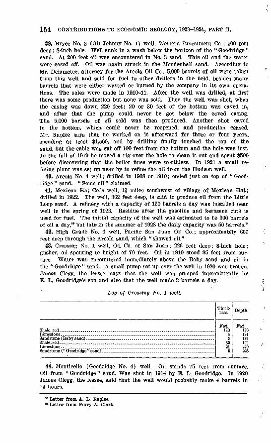
154 CONTRIBUTIONS TO ECONOMIC GEOLOGY, 1923-1924, PART II.
39. Bryce No. 2 (Oil Johnny No. 1) well, Western Investment Co.; 500 feet deep; 8-inch hole. Well sunk in a wash below the horizon of the " Goodridge " sand. At 200 feet oil was encountered in No. 3 sand. This oil and the water were cased off. Oil was again struck in the Mendenhall sand. According to Mr. Delameter, attorney for the Arcola Oil Co., 5,000 barrels of oil were taken from this well and sold for fuel to- other drillers in the field, besides many barrels that were either wasted or burned by the company in its own opera tions. The sales were made in 1910-11. After the well was drilled, at first there was some production but none was sold. Then the well was shot, when the casing was down 220 feet; 20 or 30 feet of the bottom was caved in, and after that the pump could never be got below the caved casing. The 5,000 barrels of oil sold was then produced. Another shot caved in the bottom, which could never be reopened, and production ceased. Mr. Raplee says that he worked on it afterward for three or four years, spending at least $1,500, and by drilling finally touched the top of the sand, but the cable was cut off 100 feet from the bottom and the hole was lost. In the fall of 1919 he moved a rig over the hole to clean it out and spent $500 before discovering that the boiler flues were worthless. In 1921 a small re fining plant was set up near by to refine the oil from the Hudson well.
40. Arcola No. 4 well; drilled in 1908 or 1910; ended just on top of " Good- ridge " sand. " Some oil" claimed.
41. Mexican Hat Co.'s well, 1$ miles southwest of village of Mexican Hat; drilled in 1922. The well, 362 feet deep, is said to produce oil from the Little Loop sand. A refinery with a capacity of 150 barrels a day was installed near well in the spring of 1923. Residue after the gasoline and kerosene cuts is used for fuel. The initial capacity of the well was estimated to be 300 barrels of oil a day,33 but late in the summer of 1923 the daily capacity was 50 barrels.34
42. High Grade No. 6 well, Pacific San Juan Oil Co.; approximately 600 feet deep through the Arcola sand, which " showed oil."
48. Crossing No. 1 well, Oil Co. of San Juan; 226 feet deep; 8-inch hole; gusher, oil spouting to height of 70 feet. Oil in 1910 stood 95 feet from sur face. Water was encountered immediately above the Baby sand and oil in the " Goodridge " sand. A small pump set up over the well in 1920 was broken. James Clegg, the lessee, says that the well was pumped intermittently by E. L. Goodridge's son and also that the well made 3 barrels a day.
of Crossing No. 1 well.
Limestone... _________________________________________Sandstone (Baby sand) __________________________________Shale, red ___________________________________________Limestone. .. _ __ ____ ______________ _____________ ....Sandstone ("Goodridge "sand). ........................................................
Thick ness.
Feet. 130
45
6021
6
Depth.
Feet. 130134139199220228
44. Monticello (Goodridge No. 4) well. Oil stands 75 feet from surface. Oil from " Goodridge " sand. Was shot in 1914 by E. L. Goodridge. In 1920 James Clegg, the lessee, said that the well would probably make 4 barrels in 24 hours.
33 Letter from, A. L. Raplee. 84 Letter from Perry A. Clark.

GEOLOGIC STRUCTURE OF SAK JUAN CANYON, UTAH. 155
Log of Monticello well.
.
Shale.... _ ... ________ . __ ................... _ ................ _ ......Sandstone (Baby sand) ... ________________________________Limestone and red shale... .............................................................Shale, red ......... ...... ....................... ....................................
Shale, red _______________________________________Sandstone and shale....... .............................................................Sandstone, oil-bearing ...................................................................
Sandstone ("Qoodridge" sand penetrated to a depth of 53 feet) ____________ ..
Thick ness.
Feet. 137
ejQl
?3
117
101753
Depth.
Feet. 137143}153162165176183193210263
45. Goodridge well No. 1. No Information except location.MacMorran well; 200 feet deep; 8-inch hole. Cuts " Goodridge " sand, where
oil and some gas were encountered. Location not known.Bitter Springs No. 1 well; 200 feet deep; 8-inch hole. Struck oil in " Good
ridge " sand. Well is plugged. Data from Gregory's report; location not given.Bitter Springs No. 2 well; 160 feet deep. Drilling stopped on account of
repairs to rig. Data from Gregory's report; location not given.Slickhorn Gulch well; on boulder bar at mouth of Slickhorn Gulch; 267
feet deep; 8-inch hole; oil encountered; estimated yield on pumping, 50 bar rels a day.
Hulkito well, Monumental Oil Co.; SW. \ NW. \ sec. 35, T. 42 S., R. 17 E. Was being, drilled in 1920, when it had reached depth of 1,200 to 1,300 feet.
Alhambra Rock wells. E. J. Longyear Exploration Co. under contract with the Monumental Oil Co. recently drilled a well with diamond drill in the SE. \ sec. 19, T. 42 S., R, 18 E., near Alhambra Rock, and is now (August, 1923) drilling a well in the center of sec. 24, T. 42 S., R. 17 E., also near Alhambra Rock.
Organ Rock well. The Sullivan Machinery Co., under contract with Wilson Cranmer & Co., of Denver, Colo., is now (March, 1924) putting down a dia mond-drill hole on the Organ Rock anticline 3 miles southeast of Organ Rock. The well, which is reported to have reached a depth of 2,600 feet, started in the top of the Coconino sandstone, then passed through this sandstone into the Supai (?) formation, and next entered the Goodridge formation at a depth reported to be 865 feet,
101374° 25 11
