geologic map of the oro valley 7½' quadrangle and …repository.azgs.az.gov › sites ›...
TRANSCRIPT
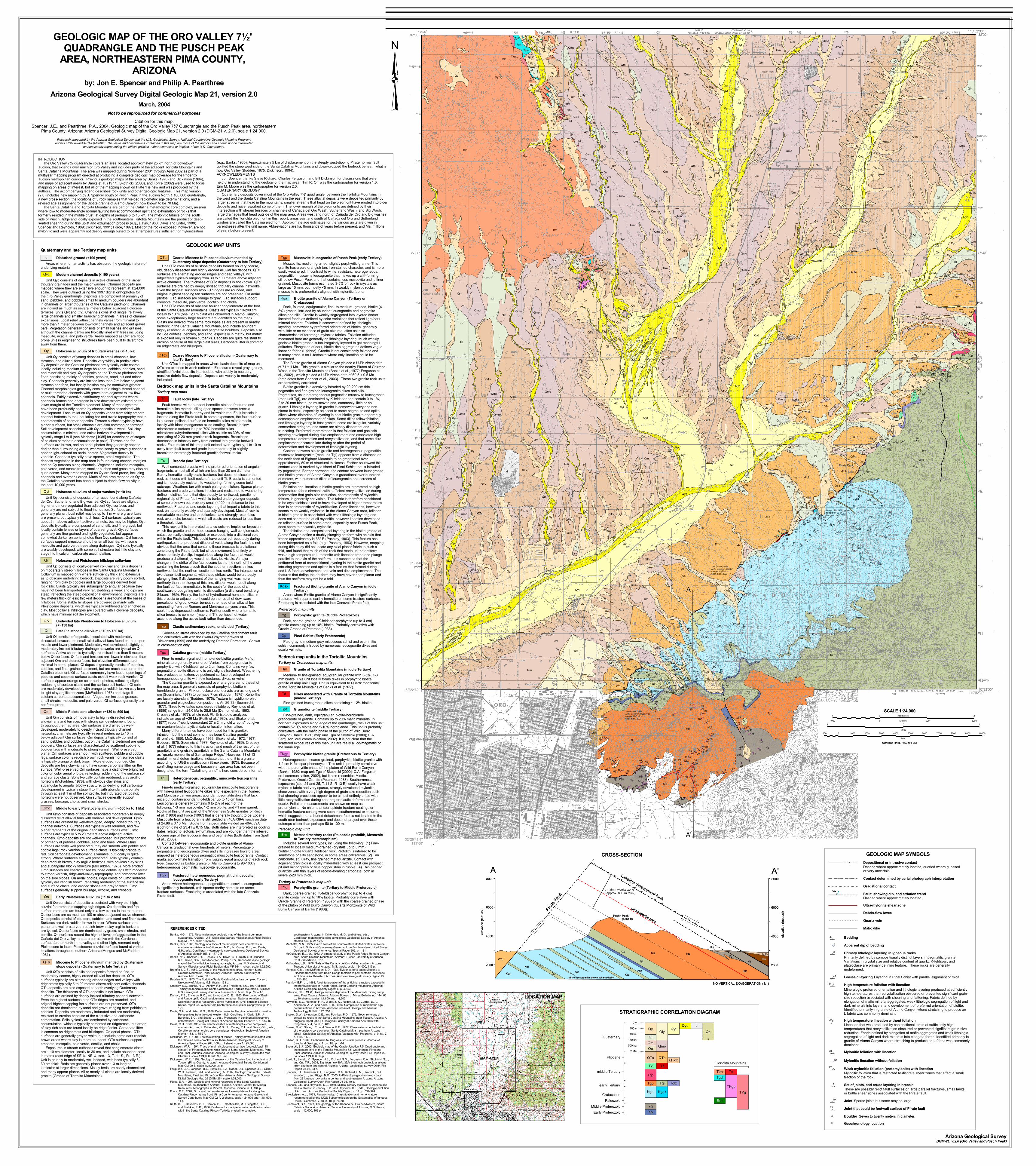
GEOLOGIC MAP UNITS
Disturbed ground (<100 years)d Areas where human activity has obscured the geologic nature ofunderlying material.
Modern channel deposits (<100 years)Qyc Unit Qyc consists of deposits in active channels of the largertributary drainages and the major washes. Channel deposits aremapped where they are extensive enough to represent at 1:24,000scale. They were outlined using the 1997 digital orthophotos forthe Oro Valley quadrangle. Deposits are composed of primarily ofsand, pebbles, and cobbles; small to medium boulders are abundantin channels of larger tributaries of the Catalina piedmont. Channelsare incised as much as several meters below adjacent Holoceneterraces (units Qyt and Qy). Channels consist of single, relativelylarge channels and smaller branching channels in areas of channelexpansions. Local relief within channels varies from minimal tomore than 1 meter between low-flow channels and adjacent gravelbars. Vegetation generally consists of small bushes and grasses,although the channel banks are typically lined with trees includingmesquite, acacia, and palo verde. Areas mapped as Qyc are floodprone unless engineering structures have been built to divert flowaway from them.
Holocene alluvium of tributary washes (<~10 ka)Qy Unit Qy consists of young deposits in small channels, lowterraces, and alluvial fans. Deposits vary widely in particle size.Qy deposits on the Catalina piedmont are typically quite coarse,locally including medium to large boulders, cobbles, pebbles, sand,and minor silt and clay. Qy deposits on the Tortolita piedmont arefiner, consisting mainly of cobbles, pebbles, sand, silt and minorclay. Channels generally are incised less than 2 m below adjacentterraces and fans, but locally incision may be somewhat greater.Channel morphologies generally consist of a single-thread channelor multi-threaded channels with gravel bars adjacent to low flowchannels. Fairly extensive distributary channel systems wherechannels branch and decrease in size downstream existed on thelower margin of the Tortolita piedmont. Many of these systemshave been profoundly altered by channelization associated withdevelopment. Local relief on Qy deposits varies from fairly smoothchannel bottoms to the undulating bar-and-swale topography that ischaracteristic of coarser deposits. Terrace surfaces typically haveplanar surfaces, but small channels are also common on terraces.Soil development associated with Qy deposits is weak. Soil clayaccumulation is minimal, and calcic horizon development istypically stage I to II (see Machette [1985] for description of stagesof calcium carbonate accumulation in soils). Terrace and fansurfaces are brown, and on aerial photos they generally appeardarker than surrounding areas, whereas sandy to gravelly channelsappear light-colored on aerial photos. Vegetation density isvariable. Channels typically have sparse, small vegetation. Thedensest vegetation in the map area is found along channel marginsand on Qy terraces along channels. Vegetation includes mesquite,palo verde, and acacia trees; smaller bushes and grass may also bequite dense. Many areas mapped as Qy are flood prone, includingchannels and overbank areas. Much of the area mapped as Qy onthe Catalina piedmont has been subject to debris flow activity inthe past 10,000 years.
Holocene alluvium of major washes (<~10 ka)Qyt Unit Qyt consists of deposits of terraces found along Cañadadel Oro, Sutherland, and Big washes. Qyt surfaces are slightlyhigher and more vegetated than adjacent Qyc surfaces andgenerally are not subject to flood inundation. Surfaces aregenerally planar; local relief may be up to 1 m where gravel barsare present, but typically is much less. Qyt surfaces typically areabout 2 m above adjacent active channels, but may be higher. Qytdeposits typically are composed of sand, silt, and fine gravel, butlocally contain lenses or layers of coarser gravel. Qyt surfacesgenerally are fine-grained and lightly vegetated, but appearsomewhat darker on aerial photos than Qyc surfaces. Qyt terracesurfaces support creosote and other small bushes, with somemesquite and palo verde trees along drainages. Qyt soils typicallyare weakly developed, with some soil structure but little clay andstage I to II calcium carbonate accumulation.
Holocene and Pleistocene hillslope colluviumQc Unit Qc consists of locally-derived colluvial and talus depositson moderately steep hillslopes in the Santa Catalina Mountains.Colluvium is mapped only where sufficiently thick and extensiveas to obscure underlying bedrock. Deposits are very poorly sorted,ranging from clay to cobbles and large boulders derived fromrockfalls. Clasts typically are subangular to angular because theyhave not been transported very far. Bedding is weak and dips aresteep, reflecting the steep depositional environment. Deposits are afew meters thick or less; thickest deposits are found at the bases ofhillslopes. Some stable hillslopes are covered primarily withPleistocene deposits, which are typically reddened and enriched inclay. Most colluvial hillslopes are covered with Holocene deposits,which have minimal soil development.
Undivided late Pleistocene to Holocene alluvium(<~130 ka)
Qly
Late Pleistocene alluvium (~10 to 130 ka)Ql Unit Ql consists of deposits associated with moderatelydissected terraces and small relict alluvial fans found on the upper,middle and lower piedmont. Moderately well developed, slightly tomoderately incised tributary drainage networks are typical on Qlsurfaces. Active channels typically are incised less than 5 metersbelow Ql surfaces. Ql fans and terraces are lower in elevation thanadjacent Qm and oldersurfaces, but elevation differences areminimal in some places. Ql deposits generally consist of pebbles,cobbles, and finer-grained sediment, but are much coarser on theCatalina piedmont. Ql surfaces commonly have loose, open lags ofpebbles and cobbles; surface clasts exhibit weak rock varnish. Qlsurfaces appear orange on color aerial photos, reflecting slightreddening of surface clasts and the surface soil horizon. Ql soilsare moderately developed, with orange to reddish brown clay loamto light clay argillic horizons (McFadden, 1978) and stage IIcalcium carbonate accumulation. Vegetation includes grasses,small shrubs, mesquite, and palo verde. Ql surfaces generally arenot flood prone.
Middle Pleistocene alluvium (~130 to 500 ka)Qm Unit Qm consists of moderately to highly dissected relictalluvial fans and terraces with strong soil development foundthroughout the map area. Qm surfaces are drained by well-developed, moderately to deeply incised tributary channelnetworks; channels are typically several meters up to 10 mbelow adjacent Qm surfaces. Qm deposits typically consist ofsand, pebbles and cobbles, but on the Catalina piedmont are quitebouldery. Qm surfaces are characterized by scattered cobble toboulder lags with moderate to strong varnish. Well-preserved,planar Qm surfaces are smooth with scattered pebble and cobblelags; surface color is reddish brown rock varnish on surface clastsis typically orange or dark brown. More eroded, rounded Qmdeposits are less clay-rich and have some carbonate litter on thesurface. Well-preserved Qm surfaces have a distinctive bright redcolor on color aerial photos, reflecting reddening of the surface soiland surface clasts. Soils typically contain reddened, clay argillichorizons (McFadden, 1978), with obvious clay skins andsubangular to angular blocky structure. Underlying soil carbonatedevelopment is typically stage II to III, with abundant carbonatethrough at least 1 m of the soil profile, but indurated petrocalcichorizons were not observed. Qm surfaces generally supportgrasses, bursage, cholla, and small shrubs.
Middle to early Pleistocene alluvium (~500 ka to 1 Ma)Qmo Unit Qmo consists of deposits associated moderately to deeplydissected relict alluvial fans with variable soil development. Qmosurfaces are drained by well-developed, deeply incised tributarychannel networks. Surfaces are typically well rounded, and fewplanar remnants of the original deposition surfaces exist. Qmosurfaces are typically 5 to 20 meters above adjacent activechannels. Qmo deposits are not well-exposed, but probably consistof primarily of pebbles, cobbles, sand and fines. Where Qmosurfaces are fairly well preserved, they are smooth with pebble andcobble lags; rock varnish on surface clasts is typically orange tored. Soil carbonate development is variable, but locally is quitestrong. Where surfaces are well preserved, soils typically containdeep reddish brown, clay argillic horizons, with obvious clay skinsand subangular blocky structure (McFadden, 1978). More erodedQmo surfaces are characterized by loose cobble lags with moderateto strong varnish, ridge-and-valley topography, and carbonate litteron the side slopes. On aerial photos, ridge crests on Qmo surfacestypically are reddish brown, reflecting reddening of the surface soiland surface clasts, and eroded slopes are gray to white. Qmosurfaces generally support bursage, ocotillo, and creosote.
Early Pleistocene alluvium (~1 to 2 Ma)Qo Unit Qo consists of deposits associated with very old, high,alluvial fan remnants capping high ridges. Qo deposits and fansurface remnants are found only in a few places in the map area.Qo surfaces are as much as 100 m above adjacent active channels.Qo deposits consist of boulders, cobbles, and sand and finer clasts.Surfaces are dark reddish brown in color. Where surfaces areplanar and well-preserved, reddish brown, clay argillic horizonsare typical. Qo surfaces are dominated by grass, small shrubs, andocotillo. Qo surfaces record the highest levels of aggradation in theCañada del Oro valley, and are correlative with the Cordonessurface farther north in the valley and other high, remnant earlyPleistocene to latest Pleistocene alluvial surfaces found at variouslocations throughout southern Arizona (Menges and McFadden,1981).
Miocene to Pliocene alluvium mantled by Quaternaryslope deposits (Quaternary to late Tertiary)
QTs
Unit QTs consists of hillslope deposits formed on fine- tomoderately-coarse, highly eroded alluvial fan deposits. QTssurfaces typically are alternating eroded ridges and valleys withridgecrests typically 5 to 20 meters above adjacent active channels.QTs deposits are also exposed beneath overlying Quaternarydeposits. The thickness of QTs deposits is not known. QTssurfaces are drained by deeply incised tributary channel networks.Even the highest surfaces atop QTs ridges are rounded, andoriginal highest capping fan surfaces are not preserved. QTsdeposits are dominated by sand and gravel ranging from pebbles tocobbles. Deposits are moderately indurated and are moderatelyresistant to erosion because of the clast size and carbonatecementation. Soils typically are dominated by carbonate.accumulation, which is typically cemented on ridgecrests, but areasof clay-rich soils are found locally on ridge flanks. Carbonate litteris common on ridgecrests and hillslopes. On aerial photos, QTssurfaces are generally gray to white, but include some dark reddishbrown areas where clay is more abundant. QTs surfaces supportcreosote, mesquite, palo verde, ocotillo, and cholla. Exposures in stream cutbanks reveal that conglomerate clastsare 1-10 cm diameter, locally to 30 cm, and include abundant sandin matrix (east edge of SE ¼, NE ¼, sec. 13, T. 11 S., R. 13 E.).Unit is crudely to moderately well bedded, with beds typically 5-30 cm thick. Beds are generally planar over 1-3 m lengths,lenticular at larger dimensions. Mostly beds are poorly channelizedand many appear planar. All or nearly all clasts are locally derivedgranite (Granite of Tortolita Mountains).
Coarse Miocene to Pliocene alluvium mantled byQuaternary slope deposits (Quaternary to late Tertiary)
QTc
Unit QTc consists of hillslope deposits formed on very coarse,old, deeply dissected and highly eroded alluvial fan deposits. QTcsurfaces are alternating eroded ridges and deep valleys, withridgecrests typically ranging from 30 to 100 meters above adjacentactive channels. The thickness of QTc deposits is not known. QTcsurfaces are drained by deeply incised tributary channel networks.Even the highest surfaces atop QTc ridges are rounded, andoriginal highest capping fan surfaces are not preserved. On aerialphotos, QTc surfaces are orange to gray. QTc surfaces supportcreosote, mesquite, palo verde, ocotillo, and cholla. Unit QTc consists of massive boulder conglomerate at the footof the Santa Catalina Mountains. Clasts are typically 10-200 cm,locally to 10 m (one ~20 m clast was observed in Alamo Canyon;some exceptionally large boulders are identified on the map).Clasts are derived from same rock types as are present in nearbybedrock in the Santa Catalina Mountains, and include abundant,highly resistant leucogranite and pegmatite boulders. Deposits alsoinclude cobbles, pebbles, and sand, especially in matrix, but matrixis exposed only is stream cutbanks. Deposits are quite resistant toerosion because of the large clast sizes. Carbonate litter is commonon ridgecrests and hillslopes.
Coarse Miocene to Pliocene alluvium (Quaternary tolate Tertiary)
QTcx
Unit QTcx is mapped in areas where basin deposits of map unitQTc are exposed in wash cutbanks. Exposures reveal gray, grussy,stratified fluvial deposits interbedded with cobbly to bouldery,massive debris-flow deposits. Deposits are weakly to moderatelyindurated.Bedrock map units in the Santa Catalina MountainsTertiary map units
Fault rocks (late Tertiary)Tf Fault breccia with abundant hematite-stained fractures andhematite-silica material filling open spaces between brecciafragments. Hematite is earthy and brownish red. Fault breccia islocated along the Pirate fault. In some exposures, the fault surfaceis a planar, polished surface on hematite-silica microbreccia,locally with black manganese oxide coating. Breccia belowmicrobreccia surface is up to 70% hematite silicamicrobreccia/hydrothermal silica with as little as 30% of rockconsisting of 2-20 mm granitic rock fragments. Brecciationdecreases in intensity away from contact into granitic footwallrocks. Fault rocks of this map unit extend over, typically, 1 to 10 maway from fault trace and grade into moderately to slightlybrecciated or strongly fractured granitic footwall rocks.
Breccia (late Tertiary)Tx Well cemented breccia with no preferred orientation of angularfragments, almost all of which are less than 20 cm diameter.Earthy hematite locally coats fractures but does not discolor therock as it does with fault rocks of map unit Tf. Breccia is cementedand is moderately resistant to weathering, forming some boldoutcrops. Weathers tan with much pale green lichen. Sparse planarfractures and crude variations in color and resistance to weatheringdefine indistinct fabric that dips steeply to northwest, parallel toregional dip of Pirate fault which is buried under younger depositsat some unknown but probably small (<100 m) distance to thenorthwest. Fractures and crude layering that impart a fabric to thisrock unit are only weakly and sparsely developed. Most of rock isremarkable massive and directionless, and strongly resemblesrock-avalanche breccia in which all clasts are reduced to less thana threshold size. This rock unit is interpreted as a co-seismic implosion breccia inwhich the granite and perhaps coarse hanging-wall conglomeratecatastrophically disaggregated, or exploded, into a dilational voidwithin the Pirate fault. This could have occurred repeatedly duringearthquakes that produced dilational voids along the fault. It is notobvious that the area that contains these breccias is a dilationalzone along the Pirate fault, but since movement is entirely oralmost entirely dip slip, irregularities along the fault that wouldproduce a dilational jog would not likely be visible. A majorchange in the strike of the fault occurs just to the north of the zonecontaining the breccia such that the southern sections strikesnorthwest but the northern section strikes north. The intersection oftwo planar fault segments with these strikes would be a steeplyplunging line. If displacement of the hanging-wall was morenortherly than the plunge of this line, dilation would result alongthe fault surface immediately to the south for the case of asouthward-propagating seismic dislocation (a dilational bend, e.g.,Sibson, 1989). Finally, the lack of hydrothermal hematite-silica inthis breccia or adjacent to it could be the result of downwardpercolation of groundwater beneath the head of an alluvial fanemanating from the Romero and Montrose canyons area. Thiscould have depressed isotherms. Farther south where hematite-silica breccia is common (map unit Tf), perhaps hot waterascended along the active fault rather than descended.
Catalina granite (middle Tertiary)Tgc Fine- to medium-grained, hornblende-biotite granite. Maficminerals are generally unaltered. Varies from equigranular toporphyritic, with K-feldspar up to 2 cm long. Contains very fewpegmatite or aplite dikes and is only slightly fractured. Weatheringhas produced an extensive pediment surface developed onhomogeneous granite with few fractures, dikes, or veins. The Catalina granite is exposed over a large area northeast ofthe map area. It generally consists of porphyritic biotite ±hornblende granite. Pink orthoclase phenocrysts are as long as 4cm (Suemnicht, 1977) to perhaps 7 cm (Budden, 1975). Xenolithsare locally abundant (Budden, 1975). Texture is hypidiomorphicgranular and plagioclase composition is An 26-32 (Suemnicht,1977). Three K-Ar dates considered reliable by Reynolds et al.(1986) range from 24.0 Ma to 25.6 Ma (Damon et al., 1963;Creasey et al., 1977), whole rock Rb-Sr isotopic analysesindicate an age of ~26 Ma (Keith et al.,1980), and Shakel et al.(1977) report "nearly concordant 27 ± 2 m.y. old zircons" but giveno uranium-lead analytical data or location information. Many different names have been used for this granitoidintrusion, but the most common has been Catalina granite(Bromfield, 1950; McCullough, 1963; Shakel et al., 1972, 1977;Budden, 1975; Suemnicht, 1977; Reynolds et al., 1986). Creaseyet al. (1977) referred to this intrusion, and much of the rest of thegranitoids and gneissic granitoids in the Santa Catalina Mountains,as "quartz monzonite of Samaniego Ridge." However, 11 of 13modal mineral determinations indicate that the unit is a graniteaccording to IUGS classification (Streckeisen, 1973). Because ofconflicting name usage and because a type area has not beendesignated, the term "Catalina granite" is here considered informal.
Heterogeneous, pegmatitic, muscovite leucogranite(early Tertiary)
Tgl
Fine-to medium-grained, equigranular muscovite leucogranitewith fine-grained leucogranite dikes and, especially in the Romeroand Montrose canyon areas, abundant pegmatite dikes that lackmica but contain abundant K-feldspar up to 15 cm long.Leucogranite generally contains 0 to 2% of each of thefollowing, 1-3 mm muscovite, 1-2 mm biotite, and <1 mm garnet.Rocks of this unit are part of the Wilderness Suite granites of Keithet al. (1980) and Force (1997) that is generally thought to be Eocene.Muscovite from a leucogranite still yielded an 40Ar/39Ar isochron dateof 24.96 ± 0.13 Ma. Biotite from a pegmatite yielded an 40Ar/39Arisochron date of 23.41 ± 0.15 Ma. Both dates are interpreted as coolingdates related to tectonic exhumation, and are younger than the inferredEocene age of the leucogranites and pegmatites (both dates from Spellet al., 2003). Contact between leucogranite and biotite granite of AlamoCanyon is gradational over hundreds of meters. Percentage ofpegmatite and leucogranite dikes and sills increases toward areamapped as heterogeneous pegmatitic muscovite leucogranite. Contactmarks approximate transition from roughly equal amounts of each rocktype, (mapped as biotite granite of Alamo Canyon) to 90-100%heterogeneous pegmatitic muscovite leucogranite.
Tsu Concealed strata displaced by the Catalina detachment faultand correlative with with the Swan-Craycroft gravels ofDickenson (1999) and the underlying Pantano Formation. Shownin cross-section only.
Clastic sedimentary rocks, undivided (Tertiary)
Fractured, heterogeneous, pegmatitic, muscoviteleucogranite (early Tertiary)
Tglx
Areas where heterogeneous, pegmatitic, muscovite leucograniteis significantly fractured, with sparse earthy hematite on somefracture surfaces. Fracturing is associated with the late CenozoicPirate fault.
Biotite granite of Alamo Canyon (Tertiary orCretaceous)
Kga
Dark, foliated, equigranular, fine- to medium- grained, biotite (4-8%) granite, intruded by abundant leucogranite and pegmatitedikes and sills. Granite is weakly segregated into layered and/orlineated fabric as defined by color variations that reflect light/darkmineral content. Foliation is somewhat defined by lithologiclayering, somewhat by preferred orientation of biotite, generallywith little or no evidence of grain-size reduction as is socharacteristic of forerange mylonitic fabrics. Foliation attitudesmeasured here are generally on lithologic layering. Much weaklygneissic biotite granite is too irregularly layered to get meaningfulattitudes. Elongation of dark, biotite-rich aggregates defines vaguelineation fabric (L fabric). Granite is not consistently foliated andin many areas is an L-tectonite where only lineation could bemeasured. The Biotite granite of Alamo Canyon yielded a U-Pb zircon dateof 71 ± 1 Ma. This granite is similar to the nearby Pluton of ChirreonWash in the Tortolita Mountains (Banks et al., 1977; Ferguson etal., 2002) , which yielded a U-Pb zircon date of 69.5 ± 0.5 Ma(both dates from Spencer et al., 2003). These two granite rock unitsare tentatively correlated. Biotite granite is extensively intruded by 20-200 cm thickpegmatite and fine-grained leucogranite dikes and sills.Pegmatites, as in heterogeneous pegmatitic muscovite leucogranite(map unit Tgl), are dominated by K-feldspar and contain 0 to 1%,2 to 20 mm biotite, no muscovite and, commonly, little or noquartz. Lithologic layering in granite is somewhat wavy and non-planar in detail, especially adjacent to some pegmatite and aplitedikes where distortion of layering in host biotite granite apparentlyaccompanied emplacement of dikes. Some dikes follow foliationand lithologic layering in host granite, some are irregular, variablyconcordant stringers, and some are simply discordant andtruncating. Preferred interpretation is that foliation and gneissiclayering developed during dike emplacement and associated hightemperature deformation and recrystallization, and that some dikeemplacement occurred late during or after the period ofdeformation and development of lithologic layering. Contact between biotite granite and heterogeneous pegmatiticmuscovite leucogranite (map unit Tgl) appears from a distance onthe north face of Bighorn Mountain to be gradational overapproximately 50 m of structural thickness. Farther southwest thiscontact zone is marked by a sheet of Pinal Schist that is intrudedby pegmatites. Farther northeast, the contact between leucograniteand biotite granite of Alamo Canyon is gradational over hundredsof meters, with numerous dikes of leucogranite and screens ofbiotite granite. Foliation and lineation in biotite granite are interpreted as hightemperature fabric elements with sufficient recrystallization duringdeformation that grain-size reduction, characteristic of myloniticfabrics, is generally not visible. This fabric is therefore consideredto be crystalloblastic and to have developed at higher temperaturethan is characteristic of mylonitization. Some lineations, however,seems to be weakly mylonitic. In the Alamo Canyon area, foliationin biotite granite is associated with weak lithologic layering anddoes not seem to be at all mylonitic, however lineation developedon foliation surface in some areas, especially near Pusch Peak,does seem to be weakly mylonitic. The foliation and compositional layering in the biotite granite ofAlamo Canyon define a doubly plunging antiform with an axis thattrends approximately N 65° E (Pashley, 1963). This feature hasbeen interpreted as a fold (e.g., Pashley, 1963). However, mappingduring this study did not locate any axial planar fabric to such afold, and found that much of the rock that made up the antiformwas a high-temperature L-tectonite with lineation trend and plungeparallel to the axis of the antiform. It is suspected that theantiformal form of compositional layering in the biotite granite andintruding pegmatites and aplites is a feature that formed during Land L-S fabric development and vein and dike emplacement. Thefeatures that define the antiform may have never been planar andthus the antiform may not be a fold.
Muscovite leucogranite of Pusch Peak (early Tertiary)Tgp Muscovitic, medium-grained, slightly porphyritic granite. Thisgranite has a pale orangish tan, iron-stained character, and is moreeasily weathered, in contrast to white, resistant, heterogeneous,pegmatitic, muscovite leucogranite that makes up a cliff-formingsill below Pusch Peak and that contains less muscovite and is finergrained. Muscovite forms estimated 3-5% of rock in crystals aslarge as 10 mm, but mostly <5 mm. In weakly mylonitic rocks,muscovite is preferentially aligned with mylonitic fabric.
Fractured Biotite granite of Alamo Canyon (middleTertiary)
Kgax
Areas where Biotite granite of Alamo Canyon is significantlyfractured, with sparse earthy hematite on some fracture surfaces.Fracturing is associated with the late Cenozoic Pirate fault.Proterozoic map units
Porphyritic granite (Middle Proterozoic)Yg Dark, coarse-grained, K-feldspar-porphyritic (up to 4 cm)granite containing up to 10% biotite. Probably correlative withOracle Granite of Peterson (1938).
Pinal Schist (Early Proterozoic) Pale-gray to medium-gray micaceous schist and psammiticschist, commonly intruded by numerous leucogranite dikes andquartz veinlets.
Xp
Bedrock map units in the Tortolita MountainsTertiary or Cretaceous map units
Granite of Tortolita Mountains (middle Tertiary)Ttm Medium- to fine-grained, equigranular granite with 3-5%, 1-3mm biotite. This unit locally forms dikes in porphyritic biotitegranite of map unit TKgp. Unit is equivalent to Quartz monzoniteof the Tortolita Mountains of Banks et al. (1977).
Dikes associated with Granite of Tortolita Mountains(middle Tertiary)
Td
Fine-grained leucogranite dikes containing ~1-2% biotite.Granodiorite (middle Tertiary)Tgd
Fine-grained, dark, equigranular, biotite-hornblendegranodiorite or granite. Contains up to 20% mafic minerals. Innorthern exposures along edge of the quadrangle, rocks of this unitcontain 5-10% biotite and 5-10% hornblende. This unit is probablycorrelative with the mafic phase of the pluton of Wild BurroCanyon (Banks, 1980; map unit Tgm of Skotnicki [2000]; C.A.Ferguson, oral communication, 2002). It is not clear that thescattered exposures of this map unit are really all co-magmatic orthe same age.
Porphyritic biotite granite (Cretaceous to Tertiary)TKgp Heterogeneous, coarse-grained, porphyritic, biotite granite with1-2 cm K-feldspar phenocrysts. This unit is probably correlativewith the porphyritic phase of the pluton of Wild Burro Canyon(Banks, 1980; map unit Tgc of Skotnicki [2000]; C.A. Ferguson,oral communication, 2002), but it also resembles MiddleProterozoic Oracle Granite (Peterson, 1938). Southernmostexposures (sec. 24 and 25, T.11 S, R 13 E) locally have weakmylonitic fabric and very sparse, strongly developed myloniticshear zones with a very high degree of grain size reduction suchthat shearing processes appear to be almost entirely brittle withlittle recrystallization during shearing or plastic deformation ofquartz. Foliation measurements are shown on map asprotomylonite. No chlorite and/or epidote fracture coatings orhematite fracture coating were seen in southernmost exposures,which suggests that a buried detachment fault is not located to thesouth near bedrock exposures and does not project over theseoutcrops closer than perhaps 50 to 100 m.Paleozoic map unit
Metasedimentary rocks (Paleozoic protolith, Mesozoicto Tertiary metamorphism)
¼m
Includes several rock types, including the following: (1) Fine-grained to locally medium-grained (crystals up to 3 mm)biotite+chlorite+quartz+feldspar rock. Protolith is inferred to besandstone or silty sandstone, in some areas calcareous. (2) Tancarbonate. (3) Gray, fine grained metaquartzite. Contact withadjacent granitoids is locally mineralized with at least one prospectpit and minor green or blue copper stain in rubble. (4) Thin beddedquartzite with thin layers of recess-forming carbonate, both inlayers 2-20 mm thick.Tertiary to Proterozoic map unit
Porphyritic granite (Tertiary to Middle Proterozoic)TYg Dark, coarse-grained, K-feldspar-porphyritic (up to 4 cm)granite containing up to 10% biotite. Probably correlative withOracle Granite of Peterson (1938) or with the coarse grained phaseof the pluton of Wild Burro Canyon (Quartz Monzonite of WildBurro Canyon of Banks [1980]).
Quaternary and late Tertiary map units
INTRODUCTION The Oro Valley 7½' quadrangle covers an area, located approximately 25 km north of downtownTucson, that extends over much of Oro Valley and includes parts of the adjacent Tortolita Mountains andSanta Catalina Mountains. The area was mapped during November 2001 through April 2002 as part of amultiyear mapping program directed at producing a complete geologic map coverage for the Phoenix-Tucson metropolitan corridor. Previous geologic maps of the area by Banks (1976) and Dickinson (1994),and maps of adjacent areas by Banks et al. (1977), Skotnicki (2000), and Force (2002) were used to focusmapping on areas of interest, but all of the mapping shown on Plate 1 is new and was produced by the authors. The accompanying legend describes rock units and other geologic features. This map version(2.0) includes new mapping by J. Spencer south of Pusch Peak in the Tucson North 1:100,000 quadrangle,a new cross-section, the locations of 3 rock samples that yielded radiometric age determinations, and arevised age assignment for the Biotite granite of Alamo Canyon (now known to be 70 Ma). The Santa Catalina and Tortolita Mountains are part of the Catalina metamorphic core complex, an areawhere low- to moderate-angle normal faulting has accommodated uplift and exhumation of rocks thatformerly resided in the middle crust, at depths of perhaps 5 to 15 km. The mylonitic fabrics on the southside of Pusch Ridge and locally exposed in the southeastern Tortolita Mountains are the product of deep-seated shearing during this uplift and exhumation process (e.g., Davis, 1980; Davis and Lister, 1988;Spencer and Reynolds, 1989; Dickinson, 1991; Force, 1997). Most of the rocks exposed, however, are notmylonitic and were apparently not deeply enough buried to be at temperatures sufficient for mylonitization
(e.g., Banks, 1980). Approximately 5 km of displacement on the steeply west-dipping Pirate normal faultuplifted the steep west side of the Santa Catalina Mountains and down-dropped the bedrock beneath what isnow Oro Valley (Budden, 1975; Dickinson, 1994).ACKNOWLEDGMENTS Jon Spencer thanks Steve Richard, Charles Ferguson, and Bill Dickinson for discussions that werehelpful in understanding the geology of the map area. Tim R. Orr was the cartographer for version 1.0;Erin M. Moore was the cartographer for version 2.0.QUATERNARY GEOLOGY Quaternary deposits cover most of the Oro Valley 7½' quadrangle, between the Tortolita Mountains inthe west and the Santa Catalina Mountains in the east. These alluvial deposits were deposited primarily bylarger streams that head in the mountains; smaller streams that head on the piedmont have eroded into olderdeposits and have reworked some of them. The lower margin of the piedmonts are defined by theirintersection with stream terraces or channels of Cañada del Oro Wash, Sutherland Wash, and Big Wash,large drainages that head outside of the map area. Areas west and north of Cañada del Oro and Big washesare called the Tortolita piedmont in this report; areas east and south of Cañada del Oro and Sutherlandwashes are called the Catalina piedmont. Approximate age estimates for the various units are given inparentheses after the unit name. Abbreviations are ka, thousands of years before present, and Ma, millionsof years before present.
GEOLOGIC MAP OF THE ORO VALLEY 7½' QUADRANGLE AND THE PUSCH PEAK
AREA, NORTHEASTERN PIMA COUNTY, ARIZONA
by: Jon E. Spencer and Philip A. Pearthree
March, 2004Arizona Geological Survey Digital Geologic Map 21, version 2.0
Citation for this map:Spencer, J.E., and Pearthree, P.A., 2004, Geologic map of the Oro Valley 7½' Quadrangle and the Pusch Peak area, northeastern
Pima County, Arizona: Arizona Geological Survey Digital Geologic Map 21, version 2.0 (DGM-21,v. 2.0), scale 1:24,000.
Not to be reproduced for commercial purposes
Research supported by the Arizona Geological Survey and the U.S. Geological Survey, National Cooperative Geologic Mapping Program,under USGS award #01HQAG0098. The views and conclusions contained in this map are those of the authors and should not be interpreted
as necessarily representing the official policies, either expressed or implied, of the U.S. Government.
Arizona Geological SurveyDGM-21, v.2.0 (Oro Valley and Pusch Peak)
Banks, N.G., 1976, Reconnaissance geologic map of the Mount Lemmon quadrangle, Arizona: U.S. Geological Survey Miscellaneous Field Studies Map MF-747, scale 1:62,500.Banks, N.G., 1980, Geology of a zone of metamorphic core complexes in southeastern Arizona, in Crittenden, M.D., Jr., Coney, P.J., and Davis, G.H., eds., Cordilleran metamorphic core complexes: Geological Society of America Memoir 153, p. 177-215.Banks, N.G., Dockter, R.D., Briskey, J.A., Davis, G.H., Keith, S.B., Budden, R.T., Kiven, C.W., and Anderson, Phillip, 1977, Reconnaissance geologic map of the Tortolita Mountains quadrangle, Arizona: U.S. Geological Survey Miscellaneous Field Studies Map MF-864, 1 sheet, scale 1:62,500.Bromfield, C.S., 1950, Geology of the Maudina mine area, northern Santa Catalina Mountains, Pinal County, Arizona: Tucson, University of Arizona, M.S. thesis, 63 p.Budden, R.T., 1975, The Tortolita-Santa Catalina Mountain complex: Tucson, University of Arizona, M.S. thesis, 133 p.Creasey, S.C., Banks, N.G., Ashley, R.P., and Theodore, T.G., 1977, Middle Tertiary plutonism in the Santa Catalina and Tortolita Mountains, Arizona: U.S. Geological Survey Journal of Research, v. 5, no. 6, p. 705-717.Damon, P.E., Erickson, R.C., and Livingston, D. E., 1963, K-Ar dating of Basin and Range uplift, Catalina Mountains, Arizona: National Academy of Sciences/National Research Council Publication 1075, Nuclear Science Series, report 38, Woods Hole Conference on Nuclear Geophysics, p. 113- 121.Davis, G.A., and Lister, G.S., 1988, Detachment faulting in continental extension; Perspectives from the southwestern U.S. Cordillera, in Clark, S.P., Jr., Burchfiel, B.C., and Suppe, J., eds., Processes in continental lithosphere deformation: Geological Society of America Special Paper 218, p. 133-160.Davis, G.H., 1980, Structural characteristics of metamorphic core complexes, southern Arizona, in Crittenden, M.D., Jr., Coney, P.J., and Davis, G.H., eds., Cordilleran metamorphic core complexes: Geological Society of America Memoir 153, p. 35-77.Dickinson, W.R., 1991, Tectonic setting of faulted Tertiary strata associated with the Catalina core complex in southern Arizona: Geological Society of America Special Paper 264, 106 p., 1 sheet, scale 1:125,000.Dickinson, W.R., 1994, Trace of main displacement surface (bedrock/basin fill contact) of Pirate fault zone, west flank of Santa Catalina Mountains, Pima and Pinal Counties, Arizona: Arizona Geological Survey Contributed Map CM-94-G, scale 1:24,000, with 9 p. text.Dickenson, W.R., 1999, Geologic framework of the Catalina foothills, outskirts of Tucson (Pima County, Arizona): Arizona Geological Survey Contributed Map CM-99-B, scale 1:24,000, 31 p.Ferguson, C.A., Johnson, B.J., Skotnicki, S.J., Maher, D.J., Spencer, J.E., Gilbert, W.G., Richard, S.M., and Youberg, A., 2002, Geologic map of the Tortolita Mountains, Pinal and Pima Counties, Arizona; Arizona Geological Survey Digital Geologic Map 26 (DGM-26), scale 1:24,000.Force, E.R., 1997, Geology and mineral resources of the Santa Catalina Mountains, southeastern Arizona: Tucson, Arizona, Center for Mineral Resources, Monographs in Mineral Resource Science, n. 1, 134 p.Force, E.R., 2002, Structural reconnaissance of lower-plate rocks along the Catalina-Rincon range front, Pima County, Arizona: Arizona Geological Survey Contributed Map CM-02-A, 2 sheets, scale 1:24,000 and 1:48, 000, 11 p.Keith, S. B., Reynolds, S. J., Damon, P. E., Shafiqullah, M., Livingston, D. E., and Pushkar, P. D., 1980, Evidence for multiple intrusion and deformation within the Santa Catalina-Rincon-Tortolita crystalline complex,
southeastern Arizona, in Crittenden, M. D., and others, eds., Cordilleran metamorphic core complexes: Geological Society of America Memoir 153, p. 217-267.Machette, M.N., 1985, Calcic soils of the southwestern United States, in Weide, D.L., ed., Soils and Quaternary Geology of the Southwestern United States: Geological Society of America Special Paper 203, p. 1-21.McCullough, E.J., Jr., 1963, A structural study of the Pusch Ridge-Romero Canyon area, Santa Catalina Mountains, Arizona: Tucson, University of Arizona, Ph.D. dissertation, 67 p.McFadden, L.D., 1978, Soils of the Canada del Oro Valley, southern Arizona: Tucson, University of Arizona, M.S. thesis, scale 1:24,000, 116 p.Menges, C.M., and McFadden, L.D., 1981, Evidence for a latest Miocene to Pliocene transition from Basin-Range tectonic to post-tectonic landscape evolution in southeastern Arizona: Arizona Geological Society Digest 13, p. 151-160.Pashley, E.F., Jr., 1963, A reinterpretation of the anticlinal structure exposed in the northwest face of Pusch Ridge, Santa Catalina Mountains, Arizona: Arizona Geological Society Digest 6, p. 49-53.Peterson, N.P., 1938, Geology and ore deposits of the Mammoth mining camp area, Pinal County, Arizona: Arizona Bureau of Mines Bulletin, no. 144, 63 p., 10 sheets, scales 1:1,800 and 1:4,500.Reynolds, S.J., Florence, F. P., Welty, J. W., Roddy, M. S., Currier, D. A., Anderson, A. V., and Keith, S. B., 1986, Compilation of radiometric age determinations in Arizona: Arizona Bureau of Geology and Mineral Technology Bulletin 197, 258 p.Shakel, D.W., Livingston, D.E., and Pushkar, P.D., 1972, Geochronology of crystalline rocks in the Santa Catalina Mountains, near Tucson, Arizona: A progress report [abs.]: Geological Society of America Abstracts with Programs, v. 4, no. 6, p. 408.Shakel, D.W., Silver, L.T., and Damon, P.E., 1977, Observations on the history of the gneissic core complex, Santa Catalina Mtns., southern Arizona [abs.]: Geological Society of America Abstracts with Programs, v. 9, no. 7, p. 1169-1170.Sibson, R.H., 1989, Earthquake faulting as a structural process: Journal of Structural Geology, v. 11, n. 1/2, p. 1-14.Skotnicki, S.J., 2000, Geologic map of the Oracle Junction 7.5' Quadrangle and the eastern third of the Tortolita Mountains 7.5' Quadrangle, Pima and Pinal Counties, Arizona: Arizona Geological Survey Open-File Report 00- 04, scale 1:24,000, 19 p. Spell, T., Zanetti, K., Spencer, J.E., Richard, S.M., Ferguson, C.A., Skotnicki, S.J., and Orr, T.R., 2003, Eighteen new 40Ar/39Ar thermochronologic analyses from southern and central Arizona: Arizona Geological Survey Open-File Report 03-03, 63 p.Spencer, J.E., Isachsen, C.E., Ferguson, C.A., Richard, S.M., Skotnicki, S.J., Wooden, J., and Riggs, N.R., 2003, U-Pb isotope geochronology data from 23 igneous rock units in central and southeastern Arizona: Arizona Geological Survey Open-File Report 03-08, 40 p.Spencer, J.E., and Reynolds, S.J., 1989, Middle Tertiary tectonics of Arizona and the Southwest, in Jenney, J.P., and Reynolds, S.J., eds., Geologic evolution of Arizona: Arizona Geological Society Digest, v. 17., p. 539-574.Streckeisen, A.L., 1973, Plutonic rocks: Classification and nomenclature recommended by the IUGS Subcommission on the Systematics of Igneous Rocks: Geotimes, v. 18, n. 10, p. 26-30.Suemnicht, G.A., 1977, The geology of the Canada del Oro headwaters, Santa Catalina Mountains, Arizona: Tucson, University of Arizona, M.S. thesis, scale 1:12,000, 108 p.
REFERENCES CITED
@
@
>
> > > > >
@
Ü
Ñ
o
¦¦
¦¦
¦
¦¦
¦
¹
j
jjjj
ÑÑÑ
ô
¹Ó ÓÌÌ ¦¹ÜÓÓ
̦¦ÓÓÓ Ó
ÓÌ
¦
¦
¦¦
¦Ü ¦ ¦
Ü ÜÌ
¦¦
Ó¹
ÓÓÜÓ
Ók Ó Ó ÓÓ ÓÓÓ
Ó ÓÓÓÓÓÓÓ
ÓÓÓÓÓ
¹¹¹¹¦¦¦¦¦¦
¹
¹¹¦¹¹
¦¦
¦
¦
¦
¦
¦Ü ¦Ü¦
Ü
Ü
Ü
¦
¦ÜÜÜ
¦Üܦ ÜÜ Ü
YY
¦Y
ô
YY
Üæ
Y
Ü
¦
YY
Ü
¦¦
Y
¦¦Ü¦
YY
¦
û
Ü
¦
¦
¦Ã
Ü
¦
¦
Ü
¦
Ü
Ã
¦
û
¦
¦¦¦ ¦¦ ¦
Ã
¦
¦
¦¦
¦
¦
¦¦
¦
¦¦
¹¹
¦¦¦
¹
à Ã
½
ûû
¹
¹
¹ ¹
û
YY
¹
þ
ää
þ þ þþ þ
ä
þ
þþþ
þ
þ
þ þ
þ
þ
þþ
þ þ þþ þ þþþ
þßßþßÜþ
þ
þ
þ
þþþ
þþ
þ
þþþ
þä
þ
þ
þþþ
þþ
þ
þ
þ
ß
þþþ
ÑþÓþ Óþ Óþ
Óþ Óþ
ô
Óß
Óþ
j Óþ Óþ ÓþÓþ ÓþÓþÓþÓþ
Óþ ÓþÓþÓþÓþ
Óþ ÓþÓþÓþÓþÜÜÜ Óþ
ÓþÓþÓþÓþ ÓþÓ
þÓþÓþÓþÓþÓ
þÜÑþÑþÜÜÜ
ÜÜ
ÓþÓþ ÓþÓþ
ÜÜÜ
ÓþÜÓþÓþÓþÓ
þÓþ
Óþ
Óþ
ÜÌþ
ÜÜ
QTc
Ql
QTs
QTc
Qy QTcx
Ql
QTcQTc
QTc
Qy
Ql
QcQcQl
Qm
QTc
Qm
Qc
QcQl
Qm
Qy
QlQm
QTc
QTc
QTc
QlQl
QyQm
Ql
QTcQy
Ql
Ql
Ql
Qy
Ql
Qy
QlQm
Qm
QTc
QTc
QTc
Qc
Qy
QTc
Qc
Qy Qc
QcQcQy
Qy
Ql
Qy
QcQlQm
Qmo Qy
QTc
QTc
Qo
QlQy
Qc
Qc
QlQl
Qm
QlQl
Qy
Qm
Ql
Qm
Ql
Ql
QyQly
Qly
Qm
Qy
Qy
Ql
Qm
Ql
QTs
QTs
Qy
Qy
Qm
QTc
Qyt
QTs
Qy
Ql
Qy
Qyt
Qy
Ql Ql
QytQy
Ql
Qyt
Ql
Qyt
Qy
Qyt Qyc
QTc
Ql
QmQl
Qm
Qy
Qy
Qy
Qy
Qc
Qm
Qyt
QTs
Qm
QmQl
Qm
Ql
Ql
QlQm
QTs
Ql
Qmo
Qy
QTs
Qyc QyQl
Qm
QTs
QTsQy
QyQm
Qmo
QmQTs
Ql
Qy
Qmo
Qmo
Qm
Qmo
Qy
Qy
QycQyc
Qy
Qy
Qy
Qyc
Qy
Qyc
Qy
Qmo
Ql
QycQl
Qy
Qy
Ql
QTsQl
Qm
Qy
QTs
QTs
QTs
Qy
QTc
Qyc
QTs
Qy
Qyt
Qm
Qm
Qyt
Qm
QTs
QTs
Qmo
Ql
Qm
QTc
Qmo
QTs
Qy
Qm
Qm
Ql
QTs
Qmo
Qo
Qy
Qm
Ql
Qyt
Qyt
Qmo
Qmo
QTs
Qy
Qmo
QTs
Qy
Qy
QTs
Qm
Qmo
Qyt
Qy
Qyt
Qm
Qyt
QTs
QTs
Qm
QTc
Qyt
Qm
Qmo
Qy
Qyt
Qy
QTs
Qm
Qy
Qm
Qm
Qm
Qy
Qy
Qy
Qy
Qyt
Qm
Ql
QTs
Ql
Ql
Qy
Qm
QTs
d
Qyc
Qm
Qy
Qyt
Qmo
Qy
Qy
Qy
Qm
Qy
Qyt
Ql
Qy
Qy
Qy
QlQyc
QmQmoQmo
Ql
QTs
Qm
QTs
Qyt
Qy
Qy
Qmo
Ql
Qyt
Qy
Qm
Qm
Qm
Ql
Qm Qm
Qm
Qyt
QTs
Qy
Qy
Qyt
Qy
Qm
Qm
Qy
Ql
Qy
Qm
Qmo
Qy
Qy
Qyt
QTs
Qyc
Qyt
QTs
Qy
Qm
Ql
Qy
QTs
Qmo
Qyc
Qy
Qm
Qy
Qy
Ql
Qy
Ql
Qm
Qyt
Qmo
QTs
Ql
Qy
Qy
Qyt
Qy
Qy
QTs
d
QTs
QmoQmo
Qy
Qyt
Qmo
Qy
Qy
Qm
Qy
Qy
Ql
Qm
Qm
Qm
Qy
Qy
Ql
Qy
Qmo
Qy
Qmo
Qm
Qmo
Qyc
Qy
QmQl
Ql
QTs
Qyt
Qm
Qyc
Ql
Qyt
Qy
QTs
Qy
Qy
Qy
Qy
Qyt
Qm
Qy
Qmo
Qm
Qyt
Ql
Qyt
QTs
Qy
Qy
QTs
Ql
Qmo
Qyt
QTs
Qy
Qmo
Qmo
Qy
Qy
Qy
QTs
Qmo
Qyt
Qm
Qy
Qy
Qyt
Qm
Qyt
Qmo
Qy
Qy
Qy
Ql
Ql
QTs
Ql
Qy
Qyt
Qy
QTs
Qm
Qm
QTs
Qyt
Ql
Qy
Ql
Ql
QTs
Qy
QyQy
Ql
Ql
Qm
QTs
Qyc
Qy
Qm
Qy
Qmo
Ql
Qm
Qy
Ql
QTs
Qyc
QTs
Qyc
Qy
Ql
Qm
QTs
Qy
Qyt
Qyt
QTs
QTs
Qy
Ql
Qy
Qm
Qyc
Qm
Qmo
Qy
Qy
Qyt
Ql
Qyt
Qyt
Qy
Qy
Qy
QTc
Qy
Qm
Qy
Qyt
Qy
Qyt
Qy
Qm
Qyt
QTs
Qm
Qyt
Qyt
Qy
Qy
Qyt
Qm
Qmo
Qmo
Qy
Qy
Qy
Qyt
Qy
Qyt
Ql
Qy
Qyt
Qm
Qy
Qy
Qy
Qyt
Qyt
Qy
Qy
QTc
Qy
Qyt
Qy
Qyt
Qy
Qm
Qy
Qyt
Qyt
Qy
Qy
Ql
Qy
Qy
Qy
Qyt
Qyt
Qy
Qyt
Qy
QyQy
Qyt
Qyt
Qy
QTs
QTcx
QTcx
Qyt
Qy
Qc
QyQyt
Qyt
Ql
Ql
Ql
Qy
Qy
Qy
Qyc
QTc
Qyc
QTs
QTs
QTs
Qy
Qyc
Qy
Qm
Qyc
QTc
QTc
37
15
59
35
29
36
17
36
2031
26
63
64
64
63
68
43
18
27
4
38
41
32
3127
4330
25
1024
4532
2830
3019 26
3340
30
44
27
35
29 1318
17
35
2528
6362
48
42
4340
26 27
36 47
40
36 34 182831
1721
213222
401225
273530
30
41
46867077
64
8077 82
70 77 87
70
8083
8085
71
31
26
30
40
33
20
8218
21
20
27
17
17
15
31
37
10
5
5
1812
5
59 2520
51
12
53
10
22
5487
35
60
34
62
40
63
54 41
68
53
48
35
50
47
59
54
34
50
36
40
65
39
44
46
68
35
60
54
35
463447
67
38
48
30
29
75
52
27
20
64
45
48
8085
4860
68
62
60
54
55
68
80
80
85
80
88
80
Tgc
Tgc
Xp
Tgl
Tgc
Tgc
Tglx
Tx
Tx TglTglx
Tglx
Tglx
Tgl
Kga
Tf
Kgax
Tgl
Kga
Tf
Kgax
Kgax
Tf
Tf
Tgl
Kga
Xp
Xp
Kga
Kga
Tgl
Tgl
Tgl
Tgl
Tf
Yg
Tgp
Tgp
Tgl
TglXp
Kga
Kga
Kga
Kga
Tgl
Tgl
Tgp
Kgax
¼m
¼mTYgTtm
Tgd
TKgp
Ttm
Td
Ttm
Ttm Tgd
TYg
Td
Td
Tgd
TYg
Tgd
Ttm
TtmTtm
Tgd Ttm
Tgd
TYg
Ttm
Ttm
Ttm
Ttm
Ttm
QTsQy
Qc
Qc
Qm
Qm
Qyc
QTs
Qy
Qy
Qyc
Qy
Qy
Qy
Ttm
Ttm
Ttm
Qy
Qyc
Qy
Qy
Qy
QTs
QTs
Qy
Qy
Qyc
Qyt
Qyc
QycQyt
Qyc
QTs
Qy
Qy
QTs
QTs
Qy
Qyc
Qy
QytQy
Qyt
Qyt
Qyc
Qyc
Qy
Qy
Qm
Qm
Qyc
Qyc
Ttm
Ttm
Pirate Fault
Tgd
Qy
QlTgl
QyQy
Qyt
Qm
2830
18
33
6
29 25202731
4138
40
41
22
2929
15
46
46
39
2538
3436
28
12
46
2
27
17
2217 1020
5922
23 35 2826
25
35
18
42 2834
37 3425
18
37 27 2222
18
2018
1823
23
2734
22
30
2730
38
4030
QTc
QTc
Yg
Yg
Qc
Qy
Xp
Xp
Tgp
A'
TgpTgp
A
;
24.96 +/- 0.13 MaAr/Ar isochron, muscovitesample 12-31-01-1Spell et al., 2003
;
23.41 +/- 0.15 MaAr/Ar isochron, biotitesample 11-27-01-1Spell et al., 2003
70 +/- 1 Ma, U-Pb zirconsample 11-23-01-3Spencer et al., 2003
<
32º20'41.4''111º00'
Kga
Kga
Kga
Kga
Qc
Kga
Qy
1 0 1 2Kilometers
2000100001000 Meters1 0 1
Miles1000 0 1000 2000 3000 4000 5000 6000 7000 8000 9000 10000
Feet
SCALE 1:24,000
CONTOUR INTERVAL 40 FEET
# # # # # # # # # # # # # # # # # # # # # # # # # # # # # # # # # # # # # # # # # # # # # # # # # # # # #2000
4000
6000
8000
eleva
tion (
feet a
sl)
A A'
eleva
tion
(feet
asl)
8000
6000
4000
2000
Pirate
Fault
Catalina detachment fault
ultramylonite zonePusch Peak (5361 ft)
QTc
Kga
KgaKgaTgl Kga
Tgl Kga
Tgl
Xp Tgp Tgp
Tgp
TsuYg
Yg
sills of leucogranite shown schematically
NO VERTICAL EXAGGERATION (1:1)
2000
4000
6000
8000
eleva
tion (
feet a
sl)
A A'
eleva
tion
(feet
asl)
8000
6000
4000
2000
Pirate
Fault
Catalina detachment fault
ultramylonite zonePusch Peak (5361 ft)
QTc
Kga
KgaKgaTgl Kga
Tgl Kga
Tgl
Xp Tgp Tgp
Tgp
TsuYg
Yg
sills of leucogranite shown schematically
NO VERTICAL EXAGGERATION (1:1)
QTs
QTs
main mylonite zone(approx. 800 m thick)
CROSS-SECTION
dQycQy
QlQmQo
QTs
Tgc
Tgp
Tx
Qyt QcQly
Qmo
QTc QTcxTf
Tgl Tglx
Kga Kgax
YgXp
?Quaternary
0 y100 y10 ka
130 ka500 ka
2 Ma
TtmTgd
TKgp
¼m
TYg
Td
Tortolita MountainsPliocene
middle Tertiary
early Tertiary
Cretaceous
Early ProterozoicMiddle Proterozoic
STRATIGRAPHIC CORRELATION DIAGRAM
Paleozoic
OracleJunction
Oro Valley
MAP AREA
LOCATION MAP
N
ä56 Ü Fault, showing dip, and striation trendDashed where approximately located.
Mafic dike
Debris-flow levee
Quartz vein> > > > > > > > > > > > > > > > > >
Depositional or intrusive contactDashed where approximately located, queried where guessedor very uncertain.
@
Gradational contact
Beddingo40
Apparent dip of beddingô5
þÓ21 Mylonitic foliation with lineation
Mylonitic foliation that is restricted to discrete shear zones that affect a smallfraction of the rock.
Weak mylonitic foliation (protomylonite) with lineationÑþ22
Mineralogic preferred orientation and lithologic layering produced at sufficientlyhigh temperatures that recrystallization obscured or prevented significant grain-size reduction associated with shearing and flattening. Fabric defined byelongation of mafic mineral aggregates, weak lithologic segregation of light anddark minerals into layers, and development of preferred orientation of biotite.Identified primarily in granite of Alamo Canyon where stretching to produce anL fabric was commonly dominant.
High temperature foliation with lineation¦þ16
These are possibly relict fault surfaces or large parallel fractures, small faults,or brittle shear zones associated with the Pirate fault.
Set of joints, and crude layering in brecciaû31
Sparse joints but some may be large.JointÂ19
Joint that could be footwall surface of Pirate faultÃ71
Seven to twenty meters in diameter.BoulderY
Gneissic layering Layering in Pinal Schist with parallel alignment of mica.Ì47
Mylonitic lineation without foliationÜ30
¹65
Primarily defined by compositionally distinct layers in pegmatitic granite.Variations in crystal size and relative content of quartz, K-feldspar, andplagioclase are primary defining feature. These rocks are generallyundeformed.
Primary lithologic layering in igneous rocks
High temperature lineation without foliationLineation that was produced by constrictional strain at sufficiently hightemperatures that recrystallization obscured or prevented significant grain-sizereduction. Fabric defined by elongation of mafic aggregates and weak lithologicsegregation of light and dark minerals into elongate forms. Identified primarily ingranite of Alamo Canyon where stretching to produce an L fabric was commonlydominant.
Ü20
GEOLOGIC MAP SYMBOLS
Contact determined by aerial photograph interpretation
Geochronology locatione
Ultra-mylonite shear zone