geol. surv. iran, 41), 203-227, 1977 against the …manuelberberian.com/berberian 1977d -...
TRANSCRIPT

Geol. Surv. Iran, 41), 203-227, 19772o3
AGAINST THE RIGIDITY OF THE "LUT BLOCK"
A Seismotectonic Discussion.
by
M. BERBERIAN
GEOLOGICAL AND MINING SURVEY OF IRAN
ABSTRACT
Recent detailed geological and seismotectonic studies in the so called Lut Blockregion, have yielded much evidence contradicting the assumed rigidity of this remotearea.
Paleogeographically, the Paleozoic and Triassic rocks, typically like the Formationsof the Tabas-Shotori region, were deposited in this zone. Thus during Paleozoic andLower Triassic times the "Lut Zone" and the Tabas-Shotori region were covered bya common sea and similar conditions of sedimentation pertained in both regions.
Several distinctive periods played a dominant part in the structural build up ofthe Lut Zone and its border area. Early Kimmerian and Late Kimmerian orogenicmovements were accompanied by syntectonic metamorphism in the northern partoftheLut Zone. The above mentioned diastrophic phases were responsible for theformation of a tectonic high, the "Lut Horst", roughly coinciding with present rangesin the Lut.
It is observed that the horst-graben tectonic and block faulting had an importantrole in structural evolution of the zone, effected the facies changes and controlled thebasins. The plate-tectonic model does not tally with the geologico-structural and seismichistory of the region, and cannot explain the deformation history of the zone.
During Quaternary the Zone is characterized by volcanic activity, a sporadicseismic regime with destructive earthquakes of large magnitude, Recent faulting andearthquake faulting. Pre-Neogene compression directions have a complicated pattern,while Post-Neogene compression directions were consistent with a NE-SW trendthroughout the area.
The conventional term "Rigid Lut Block" can no longer be maintained and theauthor proposes the "Lut Zone", which is a part of Central Iran, s. str,, in. its place.

204 BERBERIAN
1. INTRODUCTION
The eastern part of the Central Iran is usually divided into two parts, a westernpart called the "Lut Block", and a strongly folded eastern part which has been named"East lranian Ranges" (Fig. 1).
According to St6cklin et al. (1972), the name Lut, in a broad sense, applies to thatlarge north-trending desert belt which extends some 700 km from the Bazaman volcanoin the south to Ferdows in the north, with an average width of 150-200km. The sparsely
Fig.
ARABIAN PLATE
GULF OF OMAN
Position of the Lut Zone in the eastern part of Central Iran on the map of the Iranian mainseismotectonic units (after .Berberian, 1976).

AGAINST LUT BLOCK 205
populated mountains and intermediate depressions farther west, in the Ravar-Dar-band-Nayband-Tabas area, are sometimes included under the name. The most typical,most desertic part of the depression east of Shahdad is often referred to in the literatureas the "Southern Lut". Some writers have restricted the name Lut to this southernpart.
1.1. False Creation of the Lut Block!
Stahl (1911), after considering the metamorphic rocks of Central Iran to be Archean age, proposed the term "Median Mass" for the first time (the term "medianmassif" was coined by the noted Austrian geologist E. Suess (1885), who was firstto point out the presence of the Colorado Plateau type "central masses" in mountainregions that are align to the folded belt surrounding them. Suess developed this conceptin Vol. 2 of his "Aspects of the Earth" (1909).
Baier (1938) discovered that some of Stahl’s metamorphic complexes in CentralIran are really metamorphosed sedimentary rocks of Jurassic age, affected by strongAlpine-type folding. Baler rejected the concept of a median mass entirely. In his view,the north and south Iranian ranges were parts of two enlarged "’double orogenies"covering the whole country, and Central lran represented the two adjacent, very mobileinternal zones, which he compared with the Pennine zone of the European Alps.
The concept of a "Rigid Lut Block" was originally developed by St6cklin et al.(1965) from their observation, in the Tabas-Ferdows area, of a similar though lessmarked contrast between the narrow fold and thrust structures of the Shotori Rangeand the simple pattern of the structures in the adjoining desert areas to the west andeast (Tabas Block and Lut Block, respectively). It was suspected that the rigidity the two blocks was a consequence of consolidation of the pre-Jurassic substratum bystrong folding in late Triassic time, as revealed in the Shotori Range by a markedunconformity at the base of the Jurassic. Late Precambrian folding, was thought tohave been another possible cause of the consolidation. They described the Lut Blockunder the title of "’Stable Areas".
Thiele (1967) used the term "Lut Block" in his re-establishment of the Iraniartstructural zones and put it in a section entitled "Foreland Areas", together with the"Arabian Shield" and "Caspian Foreland Basin".
St6cklin, Ruttner and Nabavi (1968, unpublished) showed the Lut Block on theirtectonic Map of Iran as a special structural zone of the country and included it underthe title "’Unfoided Areas".
St6cklin (1968) distinguished the "Lut Block" as one of his nine major structuralzones of lran and together with the "Turan Plateau" and the "Arabian Platform"put them under the title of "’Stable Areas". According to Stocklin (1968), "the LutBlock is an irregularly outlined, essentially north-south-trending, rigid mass smoothlysurrounded by the ranges of Central and East Iran. The remarkable north-south trendof the bordering ranges apparently was enforced by the rigid block. On the north theNayband fualt and the Shotori Range split the block into two fractions, the Lut Block

Stable Areas F o I d e d . A r e a s General SymbolsAncient Cores Alpine Structural Zones
Turan Plateau
Arabian Platform
Lut Block
Inflacamb -Triassic
platform cover
Precambrianbasement
Kopet Dagh Zagros thrust zone, ,Alborz Mrs Zagros folded belt
Central Iran East ~ran Makran
Sanandai Sirian You[lg depressions
60’
Quaternary It
~Ophi°lite~radi°larite v;cano dSoam~ e~
Granite and diorite Fault Thrustintrusions
Tertiary volcanics
metamorphisrn
GEOLOGICAL SUB¢EY OF IRAN UNITED NATIONS SPECIAL FUND PROJECTI ~~ Earthquake-GENERAtJZED TECTONIC MAP OF IRAN
Fig. 2. The supposed Lut Block on the generalized tectonic map of Iran (a fter Ruttner and StScklin).Nate Lut BIozk in the legea~l uader th~ title o~’"Stable Area" which has been cor~si deredas stable as Arabian platform and Turan plateau.

AGAINST LUT BLOCK 207
proper on the east and the Tabas Block on the west" (Fig. 2).The radiometric data disclosed by Reyre and Mohafez (1970, 1971) suggest thai
the late Triassic tectonic processes were particularly intensive in the Lut region,resulting not only in strong folding but even in a high degree of metamorphism. Reyreand Mohafez ascribed to these processes the character of a veritable orogeny, givingrise to what these authors called the "Paleo-Baluch orogene".
St6cklin and Nabavi (197l, compilers) again introduced the Lut and Tabas blocksas a "highly rigid block" in their review of the Boshruyeh Quadrangle map.
St6cklin and Nabavi (1971, unpublished), on the first proof print of the tectonicMap of/ran, separated the Lut area from the other structural zones and used the termLut Block for it (Fig. 3).
Takin (1972) invoked the plate-tectonic concept to explain the geology of Iran,and assumed a "microcontinent" produced in the Mesozoic comprising Central andeast-Central Iran, surrounded by narrow Red Sea type ocean basins, the remnantsof which are marked as coloured melange-ophiolites around the Central and EastIranian microcontinent.
Nowroozi (1972) advanced a model of small plate tectonics for the Middle Eastbased on short period seismological data and very limited tectonic data, for whichthere is very little or no field evidence. In the central part of East Iran, Nowrooziproposed a northward moving plate with vague boundaries, the "Lut Plate". In 1972,he gave a northeastward movement to the supposed Lut block, but on the ERTS-A,B(Landsat) imageries it is clear that the Lut region moved southwards along the southernextremity of the Nayband fault (the Jebal-e-Barez mountain belt is moved right laterallyalong the Nayband fault).
McKenzie (1972) expresses his views on the neotectonics of Iran based on theseismicity and the fault-plane solutions for major shocks of the area. Although hisavailable data are similar to those of Nowroozi, his proposed model is different,particularly in not including a "Lut Plate" for the east Iranian case. Comparison ofthe plates proposed in the Middle East by the above-mentioned authors shows a clearambiguity in the neotectonic interpretations of the seismicity maps and the fault planesolutions, particularly as regards the sense of relative motion of the plates. It shouldtherefore be emphasized that adequate field evidence and detailed observational dataare always required to refine the results obtained from the study of major shocks, inorder to give a choherent picture of the distribution of the shocks and to determinethe present-day crustal deformation in an area as structurally complicated as Iran.
Crawford (1972) examined the International Tectonic Map of Eurasia (Yanshin1966) and concluded that some unity of tectonic style exists in the Lut area east ofthe Oman line and west of the Chaman fault system in pakistan, with marked dif-ference from the areas to east and west. Crawford admits the conspicuous intervaldivisions in his so-called "Lut-Helmand-Oman Block", but regards it neither as partof the Arabian-Iranian platform nor as part of peninsular India. He suggested insteadthat the block could have been an island of subcontinental size in the Tethys.

Fig. 3. The boundary of the supposed Lut Block on the Tectonic Map of Iran (1971 proof print,unpublished, St6cklin and Nabavi 1971), (cf. Fig. 2 and 4).

The boundary of the supposed Lut Block on the Tectonic Map of Iran (St6cklin, Nabavi1973), (cf Fig. 3 and 2).

210 BE RBERIAN
St6cklin et al., (1972) stated that "the report area appears thus as a particularlyrepresentative part of the Lut Block, displaying a large central uplift of the con-solidated basement, whatever its true age; the gently arched, northward convex struc-tures to the north of it appear to bend around this hard core of the block". They addedthat "the Lut Block is an elongated rigid mass extending some 900 kilometres in anorth-south direction. It is largely covered by Tertiary volcanic rocks of andesiticdacitic composition and by Neogene-Quaternary continental deposits, but it exposesalso a very incomplete Mesozoic sequence of mainly shallow-marine and clasticsedimentary rocks. Permian limestone appears in a few outcrops. Mesozoic and Ter-tiary granites and diorites have intruded and partly altered the bedded rocks. Thepost-Triassic beds show a conspicuously low intensity of tectonic deformation, domi-nated by gentle warping and block faulting. The rigidity of the Lut Block is ascribedto consolidation of the pre-Upper Triassic substratum by intense folding and meta-morphism in late Triassic or earlier time; an extensive metamorphic complex exposedin the centre of the Block seems to represent an uplift of this consolidated basementand has clearly influenced the Cretaceous and Tertiary structural trends".
Stocklin and Nabavi (1973) showed the Lut Block on their tectonic map of thecountry as a separate structural zone and described it under the title of "Median Massof East Iran", a term reminiscent of Stahl’s 1911 Median Mass. They stated that the"Lacunar Jurassic-Cretaceous-Tertiary sequence of similar facies are as in CentralIran, but subhorizontal to gently warped and faulted, presumably resting on a rigidsubstratum consolidated in? late Triassic and/or earlier (? late Precambrian) time".It should be noticed that the boundaries of the supposed Lut Block is changed fromthe one of the first proof print (1971; Fig. 3)and that their block area became larger(Fig. 4)
Hushmandzadeh (1973) stated that "on the eastern edge of the "Lut Block" inDeh Salm area metamorphic complexes occur, which are the only possible Precam-brian rock in this part. These complexes are an alternation of amphibolite gneiss,mica schists and marble. These complexes are overlain by lesser metamorphosed marbleand schist containing deformed crinoid remnants. No unconformity is found betweenthese complexes and to the contrary the contact seems gradational. Are the lower highgrade complexes of Precambrian age ? No evidence is available for dating. The onlypossible, weak argument is that resting on their grade of metamorphism. Bacauseso far as present data reveal, there is no dynamothermal phase able to give rise to sucha grade of higher amphibolite facies during the Alpine orogenies in Iran episode".
Berberian and Soheili (1973) and Berberian (1974) found field evidence whichfor the first time contradicted the basic assumption of the rigidity of the Lut Block.They presented some geological-structural and seismological evidences questioningthe rigidity of the Lut Block in earlier and recent geological times. They stated that"It should be noted that the supposed Lut Block is not a really highly and old block,bacause like the metamorphosed Paleozoic sediments of Central Lut (exposed meta-morphosed Sardar and Jamal Formations), the post Triassic-we Aptian formations(Nayband, Shemshak and Upper Jurassic formations) are also metamorphosed and

AGAINST LUT BLOCK 211
specially highly deformed (vertical and overturned beds of Jurassic sequence withchevron, tight and flattened folds).
Berberian (1974) during a field investigation of the Southern Lut Zone (northernhighlands of Jaz Murian Depression) discovered that the area is the continuation ofthe Lut Zone, and that the Shotori-Shirgesht Mountain type rock facies are typicallydeveloped in the Southern Lut Zone. Consequently, he rejected the concept of a rigidblock named Lut.
According to St6cklin (1974), "the rigid Lut Block is characterized by a conspi-cuously low degree of Alpine deformation. Most of the block is covered by Tertiaryvolcanic and continental deposits, with some widely scattered outcrops of the Meso-zoic and Paleozoic substratum, and a nucleus of metamorphic rocks believed torepresent the Baikalian basement near the centre".
In the CENTO report of the second stratigraphic working group’s field surveyof 1964, the area is introduced as a "Stable Massive" on the tectonic framework ofthe Turkey, Iran and Pakistan.
Mohajer-Ashjai, Behzadi and Berberian (1975) asserted that their newly founddislocations and other lineaments within the Lut Block, in addition to its internalseismicity and Quaternary volcanic activity, support the argument against the rigidityof the Lut Block.
Cummings (1975) proposed a two dimentional model from the theory of plasticityfor describing the pattern of faults and interpreting the mechanics of deformation withinthe Lut area. He stated that "the Lut block is an area wherein the structural geologyand fault pattern is internally consistent and markedly different from the structuralgeology and fault pattern outside the block. The pattern of faults in the Lut Blockis characterized by right-slip and left-slip faults, whereas the faults north and southof the Lut area are mainly thrusts".
Motamed (1975) in his attempt to interpret the paleogeographic conditions of theLut region used the term "Rigid Lut Block".
Nabavi (1976) still accepted the term of "Lut Block" and considered the areaas a rigid block. He observed that "this part of Eastern Iran, became a "semi rigidblock", due to the movements of Early Kimmerian", and then used the term "Epi-Early Kimmerian Plate" to describe it. He changed the boundaries of his suggestedLut Block and made it smaller. He excluded the Deh Salm, Bazman and Jaz Murianfrom the Block because of the discoveries of Berberian and Soheili (1973), Berberian(1974), and Mohajer-Ashjai, Behzadi and Berberian (1975). His proPosed Lut Blockis now mostly covered by Quaternary deposits of kavir-e-Lut (Lut Desert) (Fig.5).
A review of the work carried out by different authors shows that through progressin geological investigations, the huge area of Central Iran which was first consideredby Stahl (1911)as "Median Mass." decreased in size until St6cklin et al. (1965) limitedthe Median Mass to the Lut area and proposed the term "Lut Block". Finally ia 1973,

O 300Kin.
dan
"Coloured Melange." zone
Helmond block
Arab;an ptatform
Hezor Hosjed - Koppeh Dagh
Folded Zogros
High Zagros
Khoy-Mohubad
Esfandogheh -Mar[van
1"~" "~’l Turin plate~
Gorgan- R ~sht
Alborz- Azarbayejan
Binalud Zone
Central ]ran
Lut block
Nehbondan -Khash
Makran
Depressions

AGAINST LUT BLOCK 213
St6cklin and Nabavi used the term "’Median Mass oJ’East Iran" for introducting theirLut Block. However, as has been suggested, this term does nothing to explain presentinformation. The remainder of this paper will be devoted to a refutation of the concept.
1.2. Contradictions in the shape of the supposed Lut Block
The extent and rigidity of the Lut Block as proposed previously and widely accep-ted by geologists and seismologists, is not supported by investigation of the structuralfeatures, geology, seismicity and recent tectonics. The boundaries of the presumedLut Block vary widely as drawn and interpreted by the diiferent authors who haveembraced the concept. It would therefore appear that no fundumental data wereavailable to support their arguments. Study of some of the maps shows that the Blockbecame larger from 1965 to 1973, and then from 1973 to 1976 became smaller again(Figs. 2 to 5). In itsfinal form (Nabavi 1976), al~out 86% of the supposed Rigid Block is covered by Quaternary alluvial deposits.
These facts provoke an important question: Is it necessary to postulate a structuralzone in Iran which is 80% covered by Quaternary deposits and for which there is nofield evidence? If so, what will it explain or show us? What problems will be solvedby it ?
2. Structural Evolution of the Lut Zone:
2.1. Baikalian structural stage:
No data on Precambrian history of the Lut Zone exists because no definitePrecambrian outcrops have yet been found in the area. Radiogenic age determinationsup to the present time show clear and sharp evidence of the Early Kimmerian orogeniceffects on the rocks of the central Lut area (Reyre and Mohafez 1970, 1971). unreliable radiometric age determination in the Deh Salm area gave an age of 2,000million years.
2.2. Early Kimmerian structural stage:
During Paleozoic time, platform type cover sediments were deposited in theLut Zone as in the rest of the Central Iran. The Paleozoic and Lower Triassic sedimentsof the Lut Zone are typically like the formations exposed in the Tabas-Shotori moun-tains. The Shirgesth, Padeha, Shishtu, Sardar, Jamal, Sorkh Shale and Shotori For-mations are discovered typically exposed in the central and southern Lut zone (Ber-berian 1974, Berberian and Soheili 1973). This fact shows that during Paleozoic andLower Triassic times, the "’Lut Zone" and the "Tabas-Shotori region" were covered
Fig. 5. (Facing page) Tectono-sedimentary provinces of Iran (after Nabavi, 1976). The supposedLut Block still exists but has decreased in sise considerably.
214 BERBERIAN
by "a common sea" and that similar conditions of sedimentation pertained in bothregions. Thus paleo-geographically the Lut Zone should not be separated from theCentral lran because it always has been and remains a part of Central Iran.
2.3. Early Kimmerian orogeny:
The Early Kimmerian structural stage in the Lut area ends with the depositionof the Shotori Formation and beginning of the movements of the Early Kimmerianorogeny.
The earliest clearly detectable tectonic movement in the Central Lut occurredin post Middle Triassic-pre-Rhaetic time (the Early Kimmerian orogeny, according tothe American nomenclature).
This orgogeny is clearly documented by a remarkable angular unconformityand formation of the Shotori swell in the adjacent Shotori range (Stocklin et al.,1965), and in the Shirgesth area (Ruttner et al., 1968) etc. But in these areas it was accompanied by a syntectonic regional metamorphism.
The Central Lut (Deh Salm-Chah Dashi area) is the second locality in Iran whichthe Early Kimmerian orogeny was accompanied by a synkinematic regionalmetamorphism. The first easily detectable locality is in the Sanandaj-Sirjan orogenicBelt (Berberian 1972, 1973 and 1976; seereport No. 9 this volume).
During this orogenic phase the Paleozoic and lower Triassic rocks of the CentralLut were metamorphosed. The exposed metamorphosed Sardar and Jamal Formationsin the Deh Salm-Chah Dashi area converted to gneissic schists, amphibole schists,biotite-muscovite schist, meta-quartzite with marble intercalations (Sardar Formation)and marble (Jamal Formation). The contact zone between the metamorphosed Sardarand Jamal Formations is normal (not faulted) and is marked by a few metres of whitequartzite and gneiss schist (top white sandstone of the Sardar Formation, or baseof the Jamal Formation). Above this key bed, the sedimentary facies is changed andthe medium to thick bedded marbles with chert bands and nodules are cropped out(Jamal Formation).
The grade of metamorphism in the Paleozoic rocks is lower amphibolite facies(the grade of the regional metamorphism is increased by the effects of the thermicdomes); the style of deformation is flowage and highly flattened folds.The B-lineationsand B-axis of the Early Kimmerian metamorphics have a N-S strike in the centralpart (Kahur-Sar Godar range), and a NNW-SSE direction in the northern part (archedzone near Shah Kuh). The Early Kimmerian movements end with the formation ofthe "’Lut Horst’" (a nearly north-south trending facies divider horst).
It should be noted that in the Southern Lut Zone(northern highlands ofJaz MurianDepression) no syntectonic regional metamorphism accompanied the Early Kimmerianorogeny.
It is evident that, when a regional metamorphism accompanies an orogenesis(syntectonic regional mtamorphism), the metamorphism is found in the axial zone the orogenic belt and not in the marginal zones. These central or axial metamorphicsform always the core of an orogene. It seems that the range between Deh Salm andChah Dashi (Kahur-Sar Godar range) is the axial or central unit of the orthotectonicorogene of the~Central Lut.

AGAINST LUT BLOCK 215
Glancing over t-he various geological maps of the area, tectonic map of the countryand ERTS- A imagery (Figs. 6, 7), one can see that the younger sediments andformations in the central Lut are gently arched and bent around the supposed centraluplifted and consolidated basement. With the knowledge that the metamorphiccomplex of the Paleozoic rocks (Early Kimmerian metamorphics) constructed theexposed Paleozoic basement of the central Lut, we should observe that the supposedbasement is also arched and turned parallel to the surrounding younger formations.The real Precambrian basementis not exposed, but it could be said that the youngerdeformations (younger than that of the Early Kimmerian) followed the former one.
It can therefore be concluded that during the Early Kimmerian orogeny the LutZone (the supposed Rigid Lut Block) was more mobile than the previously introducedmobile zone of the Shotori range.
2.4. Late Kimmerian structural stage:
During the Jurassic and after the Early Kimmerian diastrophism and uplift, thecentral Lut Zone was subjected to strong subsidence. The Nayband Formation, Shem-shak Formation and Upper Jurassic limestones were deposited on the older deformedrocks.
2.5. LateKimmerian movements:
The second important movement, in the central Lut Zone after the Early Kim-merian orogeny, wasthat of post Upper Jurassic-pre Lower Cretaceous(Late Kimmerianor Nevadan phase according to American nomenclature).
The diastrophism is clearly documented by a remarkable and sharp angular un-conformity of Aptian sediments over the older deformed and metamorphosed se-quences. The Late Kimmerian orogeny is accompanied by a syntectonic regional meta-morphism (lower green schist facies in the Mesozoic pre-Aptian rocks, and retrogres-sive metamorphism in the Early Kimmerian metamorphics), and a late tectonicmagmatism.
During the syntectonic metamorphism of the Late Kimmerian (Nevadan) dias-trophic phase in the central Lut, the Nayband Formation, Shemshak Formation andUpper Jurassic limestones were metamorphosed and convereted to crystallized limes-tones, low grade schists, phyllites, meta quartzites, meta siltstones, meta sandstonesand slates. These metamorphosed sequences of Jurassic age are highly deformed andschistosed. It should be emphasized that the structures in the post Triassic-pre Aptianformations are not simple in the supposed Lut Block as stated in some reports.
It seems that after the Early and Late Kimmerian orogenies (especially the formerone, as observed earlier), the central part of the supposed Lut Block (the ranges betweenDeh Salm and Cha4a Dashi) became a nearly north-south trending facies divider horst(the Lut Horst).
As mentioned berore, the Kahur-Sar Godar range is the axial and central unitof the Early Kimmerian and Nevadan orthotectonic orogenes. Outward from thisaxial unit or range (from the central part of the Lut Zone towards its edges), the grade

Fig. 6. Mosaic of the ERTS (Landsat) A imagery covering the Lut Zone and eastern part of Iran(after Mohajer-Ashjai, Behzadi and Berberian 1974).

56
USSR
/
\ e~,\ l|g l \ \ "
x ",+\\ \; .I. \ ’, \
Fig. 7. Neo-tectonic-map of eastern Iran, based on ERTS-A (Landsat) imagery, Tectonic Mapof Iran (1973), the Geological Map of lran (1959), and other references.
1--Neogene foldings; 2--taken from N.I.O.C. Geological Map 1959; 3=taken from G.S.I.Geological Report: 4 -- based on the ERTS-1 imagery 5 = direction of maximum horizontalshortening deduced from Neogene axes of folding; 6 = horizontal component of the slip vectorbased on the focal mechanism of earthquakes; 7 = sense of relative horizontal movement;8 -- Quaternary volcanoes; 9 -- horizontal component of the compressional axis based on thefocal mechanism of earthquakes; 10 = horizontal component of the compressional axis basedon the geodetic measurements; 11 -- generalized compressive direction based on the patternof the Quaternary faulting; 12 - fault active during Quaternary faulting; 13 = fault trace,(broken lines denote uncertainty); 14 = high angle reverse fault; 15 = vertical movement, (+) and down (--). After Mohajer-Ashjai, Behzadi and Berberian 1974).

218 BERBERIAN
of Nevadan metamorphism and also the grade of deformations decrease in a radialform from the axial unit.
It should be noted that near the Lut Crush Zone (junction between Lut Zoneand Flysch zone or the East Iranian Ranges), due to the faulting action and accidentbetween two different zones, the deformational grade increases (especially near thehigh angle reverse longitudinal western Neh (Nehbandan) fault).
The synkinematic regional metamorphism of the Nevadan orogeny in the CentralLut is followed by a "Late Tectonic Magmatism" (granitization) known as the "latetectonic Lut Magrnatism". These two phenomena (metamorphism and magmatism)form the second and third phases of the magmatic cycle of an orogenic belt (De Sitter1964). As the Nevadan orogenic belt in the central Lut is not a complete and a welldeveloped orogene, the first and the fourth phases are absent here.
The Late tectonic Lut Magmatism is characterized by:3- Intrusion of pegmatites
2- Granitic intrusion (Shah Kuh and related stocks=Lut Granite) with contactmetamorphism (pyroxene-hornfels facies).
1- Thermic-static metamorphism (andalusite, garnet, sillimanite schists).Preliminary micro-mega tectonic investigations showed that the B-lineations
and B-axis of the Late Kimmerian metamorphics follow that of the Early Kimmerianand have the same directions.
In the southern Lut Zone (northern highlands of Jaz Murian Depression), afterthe Early Kimmerian uplift (Lut Horst), the area remained mostly above sea leveland the Jurassic Shemshak Formation is only deposited in small separate low basins.The Lut Magmatism (late tectonic magmatism of Nevadan movements) is introducedin this part of the zone by Bazman granitic batholite accompanied by considerablecontact metamorphism. The Bazman magmatic intrusions have been differentiated inmagmatic chambers (intrusion of gabbroic and then acid igneous rocks) and in site(granitic to babbroic auroles due to assimilation of the country rocks).
2.6. Austrian structural stage and Austian movements:
The deformed and metamorphosed rocks of the Late Kimmerian in the centralLut Zone are unconformably and transgressively covered by slightly tilted (20-30degrees) beds of Aptian rocks. One cannot postualte a real rigid block in this areaby making the assumption that the Cretaceous rocks are not highly folded, becausein most parts of the Central Iran the medium to thick bedded limestones of Cretaceousage are not highly folded (except those of the coloured melange zones). However,they are extensively faulted, and this is thought to be related to the massive natureof these rocks. No Aptioan sediments have been deposited in the eastern part of theLut Horst, whereas in the western part (Deh Salm basin) Aptian sediments have beendeposited.
In the southern Lut Zone (northern highlands of Jaz Murian Depression) thetransgression of the Cretaceous sea started in Infra-Valanginian (Lower Cretaceous)time (Berberian 1975) in the small basins on the Lut Horst, and continued to Aptian.No Upper Cretaceous deposits have yet been found in this part of the zone.
The late Lower Cretaceous-pre Upper Cretaceous movements (Austrian) are do-

AGAINST LUT BLOCK 219
cumented by a sharp angular unconformity at the base of the iMaestrichtian sediments,folding, faulting and reactivation of the Lut Horst along some faults, in the Lut zone.
2.7. Laramidian structural stage and Laramidian movements:
Maestrichtian sediments are deposited only on the northern nose of the LutHorst (Except the coloured melange zones). The Lut Horst and its eastern, western,and southern adjacent basins were uplifted during Upper C, retaceous time.
The post Upper Cretaceous-pre Paleocene or Eocene movements in the CentralLut are characterized by a regional angular unconformity at the base of Paleoceneor Eocene rocks, partial metamorphism in coloured melarge, a post-tectonic volcanismand reactivation of the Lut Horst.
2.8. Pyreneean structural stage and pyreneean movements:
The distribution, thickness and facies changes of the Eocene rocks, differ in theadjacent basins of the Lut Horst. Lower Eocene rocks in the eastern basin of the centralLut Horst (Chah Dashi basin) are poorly developed, whereas they are well-developedin the western basin (Deh Salm basin).
In the southren Lut Zone (northern highlands of Jaz Murian Depression), afterLaramidian movements, the western part of the area and a small part of the easternpart, were subjected to subsidence and the Lower Eocene sequence (basal conglomerate,volcanics, tufts and etc) has been deposited on the older rocks.
The post Eocene-pre Oligocene movements (Pyreneean) are documented by regional angular unconformity at the base of the Neogene? red-beds, a late tectonicmagmatism (intrusion of gabbro, diorite, granodiorite and contact metamorphism-silicification and hornfels), and reactivation of the Lut Horst.
In the Dasht-e-Bayaz area the layered and folded Eocene volcanics are stronglyrefolded. The Lower Eocene rocks of Deh Salm area are folded and a 50 degrees diphas been measured in the limb of a syncline. In the southern part of the Lut (north ofJaz Murian) the Eocene rocks have 70 degrees dip. Some volcanic and tufts of theLut area which are massive and have no layering could not represent the deformationalfeatures as clearly as the well-layered rocks. However, it should be noted that theyare extensively faulted, and that this is thought to be related to the massive natureof these extrusive bodies. Therefore this apparent common deformation feature inthe Lut is not necessarily an indication of its rigidity, as was proposed by St6cklin(1968).
After post Eocene movements (Pyreneean) the Lut Zone underwent majoruplift and no Oligocene-Miocene sediments have been deposited "’(Major Lut Uplift)".The important sedimentary gap between Oligocene and Miocene in the Lut, and aclear angular unconformity of the (Upper Neogene?) red beds and pliocene conglo-merates, confirm the Major uplift of the Lut during the mentioned periods.
A succession of fault-bounded, horst and graben-like features is always dominantin the Lut Zone and always controlled sedimentation in the area. In the period of theMajor Lut Uplift the Lut Horst exposes the older rocks with the Lower Eocene coverwhich emerged after Pyreneean movements, while the adjacent grabens (East Iranian

220 BERBERIAN
Ranges in the east, Makran Ranges in the south, and Daman-Kasgin basin in southeast, NE Iranishahr) were still subsiding and filling with Eocene-Oligocene deposits.
2.9. Attican structural stage and Attican movements:
After the Pyreneean movements and before the Attican uplift, only some conti-nental Red Beds (Neogene ?) were deposited on parts of the Lut Zone.
The Neogene ? red beds overlie unconformably the older rocks of the southernpart of the southern Lut Zone and are slightly tilted towards the Jaz Murian Dep-ression.
In this period, in which some continental Red Beds were deposited in small basinsof the Lut Zone, the adjacent southeastern Daman-Kasgin basin was rapidly subsidingand sedimentation (Oligocene to Pliocene) was continuous. The East Iranian Rangesemerged.
Post Miocene-pre Pliocene (Attican) movements in Lut area are characterizedby a regional angular unconformity at the base of Pliocene conglomerates.
2.10. Wallachian structural stage and Wallachian movements:
It is after the Attican movements that the narrow Lut crush zone, junction betweenthe Lut Zone and East iranian Ranges, and other minor and separate basins were sub-jected to a minor subsidence and the Pliocene conglomerates were deposited.
Gentle sedimentation during Pliocene along the Lut Crush Zone and a few otherminor basins in the Lut Zone was followed by another period of unrest at the end ofPliocene or Early Quaternary. The post Pliocene-pre Quaternary movements in Lutare documented by folding of Pliocene conglomerates (vertical and even slightly over-turned beds) and a regional unconformity at the base of the old terraces and gravelfans, faulting of Pliocene conglomerates, final upheaval of the mountain ranges com-bined with strong high angle reverse longitudinal fualts, and post tectonic volcanics.
The occurrence of numerous Quaternary volcanoes is another factor which ques-tions the concept of the rigidity of the Lut Block. In the Lut, there are over fifty tinyQuaternary volcanoes composed of pyroxene andesite and other type of rocks whichhave cut their way through the supposedly rigid block. The Bazman Quaternary vol-canic activity in the southern Lut can be divided into three small sub-phases:
3- Younger andesitic fissure eruptions cutting Bazman lava flows.2- Bazman tuff breccia and the main lava flows.1- Intrusion ofdiabasic dykes.
3. Recent faulting and the seismieity of Lut Zone:
Wallachian movements, resulting in the present-day orographic picture of theLut, did not conclude the movements in the area. The recent gravel fans of the Lutarea are cut by young and perhaps active faults (especially at the junction of the Lutand the East iranian Ranges, in the Lut crush zone). The most important young faultsare the West and East high angle reverse longitudinal faults of Neh (Nehbandan)and Nayband. These faults continue northwards and southward in a remarkable nearly

Fig. Seismotectonic Map of Iran (after Berberian 1976).Note that there is no boundary for the supposed Lut Block andthat it has been considereclas a part of the central Iran.

222 BERBERIAN
north-south fault trending over 400 Kilometres.
3.1. Major Historical (pre-1900) Earthquakes:
The most important destructive earthquakes which occurred in Lut Zone aresummarized here. For more information see Berberian (1976 and 1977), (Fig.
- 856 December : Tun (Ferdows) destroyed. Damage from Neishaburto Qaen.
- 1237 : Dasht-e-Bayaz and Gonabad region were devastated.- 1336 October 21 : Khaf region destroyed. 20,000 people were killed and
fresh fault was formed.- 1493-January 10 : Nouzad-Mask region was destroyed. The earthquake
was associated with fresh faulting.- 1549-February : Qaen region was destroyed and 3.000 people were
killled.- 1679 Winter : Dasht-e-Bayaz and Gonabad region were devastated.
3.2. 20th Century Seismicity:
A summary of major events is given.here. For more information see Berberian(1976 and 1977), (Figs. 8 and
- 1918 March 24 :- 1925 December 14 :- 1928 March 08 ."- 1936 June 30 :
1941 February 16 :
1946 February 10 :
- 1946 February 12 :- 1947 March 03 :- 1947 April 09 :- 1947 September 23 :
- 1947 September 23 :- 1947 October 06 :- 1962 April 02 :
- 1963 October 31 :- 1968 August 31 :
A damaging earthquake at Bajestan region (VII).Damaging earthquake at Bajestan region (VIII).Damaging earthquake at Nehbandan (VII).Destructive earthquake at Sarbisheh region, 16 vil-lages were destroyed and many people were kleild(VIII).Chahak destructive earthquake. 600 people werekilled and 2,500 houses collapsed (IX). A fresh faultwas formed.Three people were killed at Giv (SE Birjand) (VIII).A few other villages destroyed or damaged.Sarbisheh region, an earthquake was felt (VI).An earthquake felt in Birjand (VI).An earthquake felt in Birjand (VII).Destructive earthquake at Dustabad (IX), 400 peoplewere killed.Strong aftershock at Dustabad (VII).Dustabad aftershock (VII).Mussavieh earthquake (VII). The shock destroyed200 houses and 5 people were killed.An earthquake felt in Birjand region (V).The Dasht-e-Bayaz destructive earthquake of magni-tude 7.2, which created a 90 km long fresh fault break,occurred in the centre of the northern supposed LutBlock. It killed between 7,000 and 12,000 people (X).
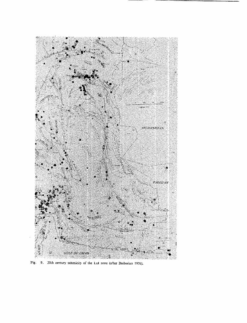
Fig. 9. 20th century seismicity of the Lut zone (after Berberian 1976).

224 BERBERIAN
- 1968 September 01 :
- 1976 November 07 :
Destructive aftershock of Dasht-e-Bayaz at Ferdows(VIII).A destructive earthquake at Qaen (VIII).
Seismic study of the postulated Lut Block shows that there is little tectonic stabi-lity in the Lut Zone. All the above-mentioned destructive earthquake, some of themwere associated with recent faulting, took place in this zone. It is therefore puzzlingthat some geologists and seismologists persits in considering the Lut Zone of Centrallran as a stable and rigid block!
4. Application of Plate Tectonic Models:
The proposed plate tectonic models for the Lut area (Nowroozi 1972, Mckenzie197:2, Takin 1972) show many ambiguities in neotectonic interpretations of the area.It should be emphasized here that the fashionable plate tectonic models and the con-cept of Lut (micro) plate are unacceptable for the area. The region is even more mobilethan the adjacent Shotori Ranges (folding, metamorphism, faulting, magmatism, vol-canism and seismicity of the Lut Zone). A succession of fault-bounded, Horst andGraben-like features was always dominant in the Lut area and alway did control sedi-mentations. For example, in the period of the Major Lut uplift, the Lut Horst exposedthe Baikalian basement and its Paleozoic- Mesozoic cover, while the adjacent Grabenswere still subsiding and were filled with Eocene-Oligocene flysch sediments (EastIranian Ranges). Comparision of the post Miocene maximum horizontal shorteningin the Lut area and adjacent regions shows a uniform NE-SW direction (Mohajer¢t al. 1975, Berberian 1976). (Fig.
Conclusion
The evidence presented in this report modify the original concept of earlier authorsand indicates that the Lut area (the former supposed Lut Block) should not be con-sidered as a rigid unity. This new argument could, in some ways, affect the interpre-tation of those authors who have based some part of their inferences on the conceptof a rigid Lut Block.
A summary of the facts contradicting the basic assumption of rigidity are asfollows:
- The Paleozoic rocks in the Lut Zone are folded, and recumbent folds are de-veloped.
- Discovery of Shotori Mountain -,type Paleozoic rocks in the Lut Zone provedthat the Shotori Mountains and the Lut Zone were covered by a commonsea during Paleozoic.
- Two phases of metamorphism and magmatism in Mesozoic represent evidenceof the :activity and mobility of the Lut Zone during Mesozoic.
AGAINST LUT BLOCK 225
- Tertiary and Qaternary volcanic activity are present in Lut.- Several major recent dislocations cut through the Lut Zone.- Direction of post Miocene maximum horizontal shortening is the same as
in adjacent regions.- Seismically, the Lut Zone is quite active and several destructive earthquakes
together with fresh faulting have taken place in the Lut Zone.

226 BERBERIAN
REFERENCES
Berberian,M., 1972. Two important deformational and metamorphic phases in the belt northeastof the Zagros Thrust line (Iran). Geol. Surv. Iran., Int. Rep. 13p.
Berberian,M., 1973. Two important deformational and metamorphic phases in the belt northeastof the Zagros Thrust line (Iran); a brief structural review of the Sanandaj-Sirjan Belt. Geol.Surv. Iran, Int. Rep., 27, 35p.
Berberian,M., 1974. Structural history of the Southern Lut Zone (Northern Highlands of Jaz MurianDepression-Baluchestan)-A preliminary field note. Geol. Surv. Iran, Int. Rep. 21p.
Berberian,M., 1976. Contribution to the Seismotectonics of Iran (Part II). Geol. Surv. Iran, Rep.No. 39, 518p., 5 maps, 259 Figures.
Berberian, M., 1977. Earthquake catalogue of Iran. Geol. Surv. Iran (forthcoming).
Berberian, M., Soheili M., 1973. Structural history of Central Lut-consolidation of the supposedLut Block during Early Kimmerian Orogeny.A preliminary field note. Geol. Surv. Iran,Int, Rep.
Baler, E., 1938. Ein Beitrag zum thema swischergebirge. Zentralbl. Mineral, Geol. Abt. B. No. 11,385-399.
Crawford, A. R. 1972. Iran, continental drift and plate Tectonics. 24th Int. Geol. long. Montreal,Sec. 3, 106-112.
Cummings, D., 1975. Theory of plasticity applied to faulting, Lut area, East - Central Iran. Geody-namics of southwest Asia. Tehran Symposium, 8-15 Sep., Geol. Surv. Iran (abst.).
Hushmandzadeh, A., 1973. Precambrian metamorphic episodes in Iran; a short review. Geol. Surv.Iran, Int. Rep. 62.
McKenzie,D., 1972. Active Tectonics of the Mediterranean region. Geophys. J.R. Astr. Soc., 30, 109-158.
Mohajer-Ashjai, A., Behzadi, H., Berberian, M., 1975 - Reflections on the rigidity of the Lut Blockand recent crustal deformation in eastern Iran. Tectonophysics, 28, 281-301.
Motamed,A., 1975. Synth6se geologique de la gen6se de Lut (Iran Oriental). Geodynamics of south-west Asia, Tehran Symposium, 8-15 Sep. Geol. Surv. Iran (abst.).
Nabavi, M. H., 1976. An introduction to the Iranian geology. Geological Survey of Iran, ll0.p.
Nowroozi, A. A., 1972. Focal mechanism of earthquakes in Persia, Turkey, West Pakistan and Af-ghanistan and plate tectonics of the Middle East. Bull. Seism. Soc. Am., 62 (3), 823-850.
Reyre, D., Mohafez, S., 1971, 1972. A first contribution of the NIOC-ERAP Agreement to the know-ledge of Iranian geology. Edition Technip, Paris.
Ruttner, A., Nabavi, M. H., Hajian, J., 1968. Geology of the Shirgesht area (Tabas area, East Iran).Geol. Surv. Iran, Rep. 4,133p.
Stahl, A. F., 1911. Persien; In handbuck der regionalen geologie. Heidelberg (winter), 8,5 (6),
AGAINST LUT BLOCK 227
St6cklin, J., 1968. Structural history and tectonics of Iran : a review. Bull. Am. Assoc. Petrol. Geol.,52 (7). P. 1229-1258.
Strcklin, J., 1974. Northern Iran : Alborz Mountains. Mesozo~c-Cenzoic Orogenic Belts, data fororogenic studies. Geol. Soc. London, Sp. Pub. 4,p. 213-234 (Collec. Ed. A.M. Spencer,Scottish Academic Press).
Strcklin, J., Eftekhar-Nezhad, J., Hushmandzadeh, A., 1965. Geology of the Shotori Range (Tabasarea, East Iran). Geol. Surv. Iran, Rep. No. 3, 69p.
Sti3cklin, J., Eftekhar-Nezhad, J., Hushmandzadeh, A., A., 1972. Central Lut reconnaissance, East/ran. Geol. Surv. Iran, Rep. No. 22.
Strcklin, J., Nabavi. M. H., 1971, 1973, Tectonic Map of/ran. Geol. Surv. Iran.
St6cklin J., Ruttner, A., Nabavi, M.H., 1968.Tectonic Map of lran. Geol. Surv. Iran (unpubbshed).
Suess, E., 1885.Das Antlitz der Erde. V.1, Prag-Leipzig.
Suess, E., 1909Das Antilitz des Erde, V.2, Wien-Leipzig
Taking, M., 1972.Iranian geology and continental drift in the Middle East.. Nature, 235 (5334), 147-150.
Thiele, O., 1967.Bemerkungen zur tektonischen Karte yon Iran. Verb. Geol. Bundesanst., nos. 1-2,p, 120-135.