geol: chapter 8 earthquakes and earth’s interior
Post on 20-Dec-2015
223 views
TRANSCRIPT
GEOL: CHAPTER 8
Earthquakes and Earth’s Interior

LO1: Explain Elastic Rebound Theory
LO2: Describe seismology
LO3: Identify where earthquakes occur, and how often
LO4: Identify different seismic waves
LO5: Discuss how earthquakes are located
Learning Outcomes
LO6: Explain how the strength of an earthquake is measured
LO7: Describe the destructive effects of earthquakes
LO8: Discuss earthquake prediction methods
LO9: Discuss earthquake control methods
Learning Outcomes, cont.

LO10: Describe Earth's interior
LO11: Examine Earth's core
LO12: Examine Earth's mantle
LO13: Describe Earth's internal heat
LO14: Examine earth's crust
Learning Outcomes, cont.

• Earthquake: shaking or trembling of the ground caused by the sudden release of energy, usually as a result of faulting, which involves the displacement of rocks along fractures
• Aftershocks: from continued adjustments along a fault; usually smaller than the initial quake
Earthquakes
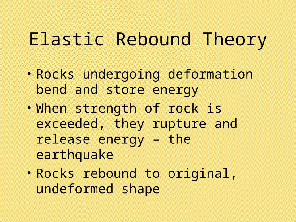
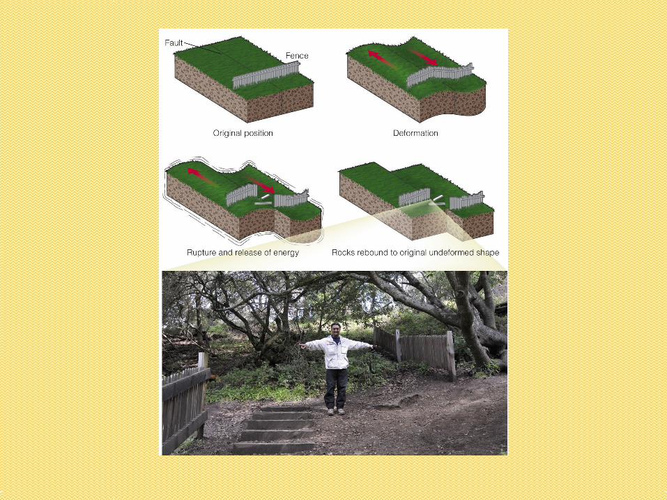
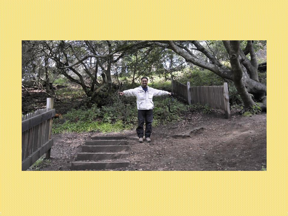
• Rocks undergoing deformation bend and store energy
• When strength of rock is exceeded, they rupture and release energy – the earthquake
• Rocks rebound to original, undeformed shape
Elastic Rebound Theory

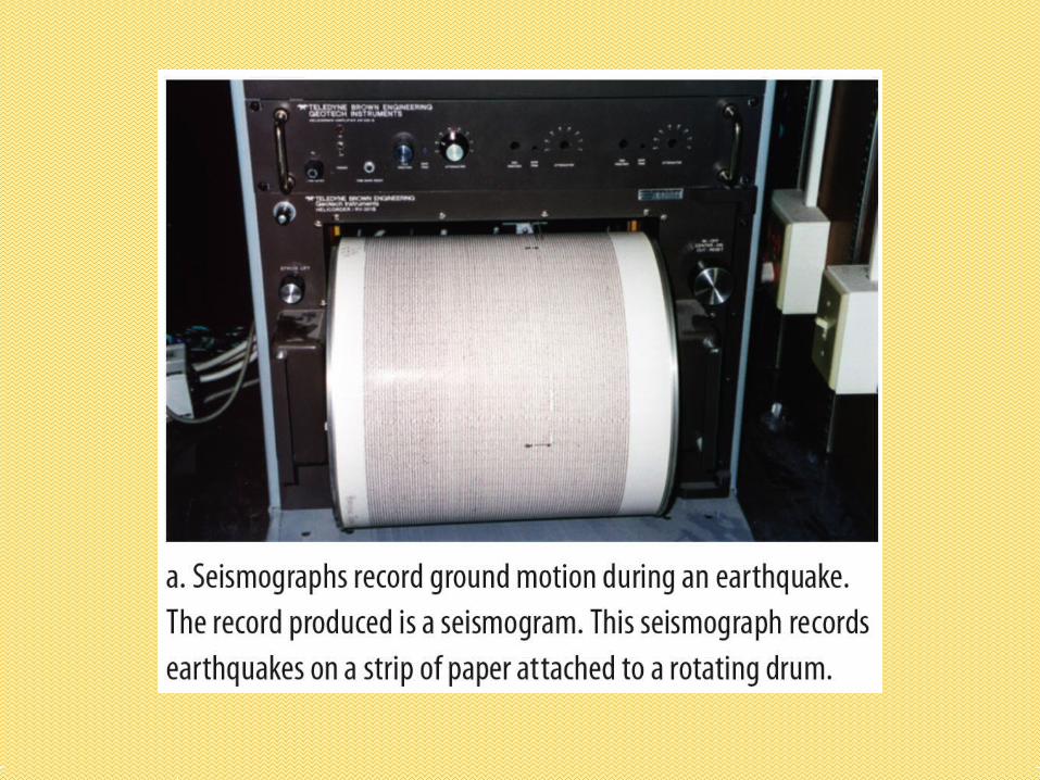
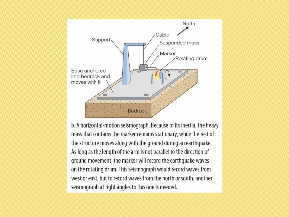
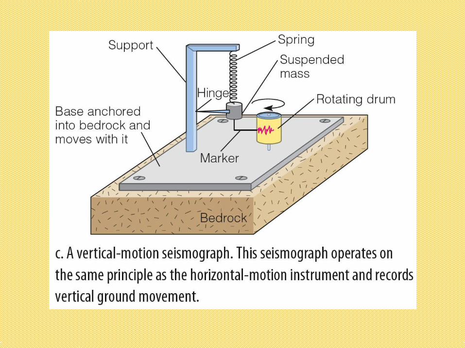
• Seismology: the study of earthquakes• Seismic waves: energy from earthquakes• Seismographs: detect, record, and measure
earthquakes• Seismogram: record from a seismograph• Earthquakes occur along faults, where
movement is stored as energy in rocks• Most faults related to plate movements
Seismology

• Focus: point where energy is first released• Epicenter: point on surface above focus• Shallow-focus: 0-70 km below surface• Intermediate focus: 70-300 km below
surface• Deep-focus: >300 km below surface• 90% less than 100 km below surface
Focus and Epicenter

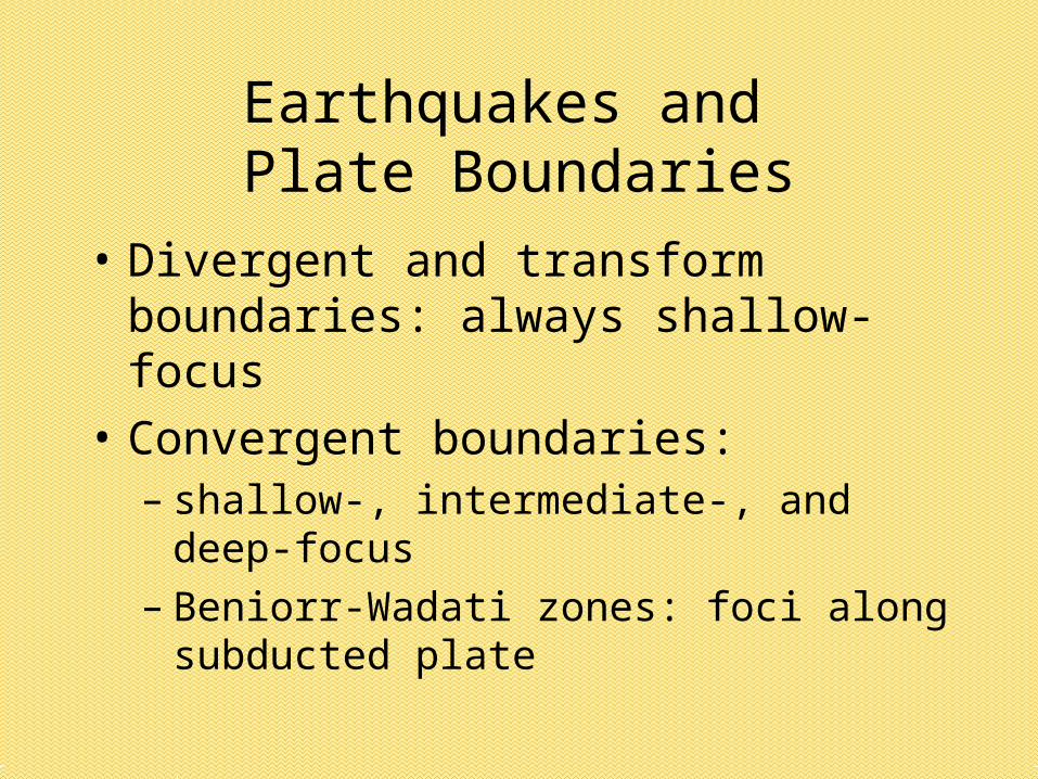
• Divergent and transform boundaries: always shallow-focus
• Convergent boundaries: – shallow-, intermediate-, and deep-focus– Beniorr-Wadati zones: foci along
subducted plate
Earthquakes and Plate Boundaries
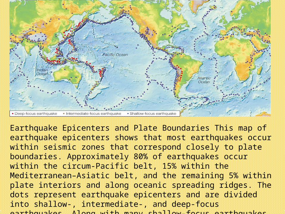
Earthquake Epicenters and Plate Boundaries This map of earthquake epicenters shows that most earthquakes occur within seismic zones that correspond closely to plate boundaries. Approximately 80% of earthquakes occur within the circum-Pacific belt, 15% within the Mediterranean–Asiatic belt, and the remaining 5% within plate interiors and along oceanic spreading ridges. The dots represent earthquake epicenters and are divided into shallow-, intermediate-, and deep-focus earthquakes. Along with many shallow-focus earthquakes, nearly all intermediate- and deep-focus earthquakes occur along convergent plate boundaries.
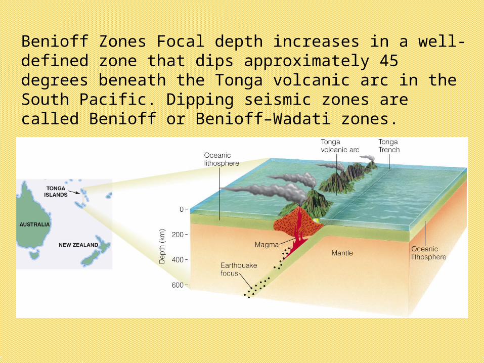
Benioff Zones Focal depth increases in a well-defined zone that dips approximately 45 degrees beneath the Tonga volcanic arc in the South Pacific. Dipping seismic zones are called Benioff or Benioff–Wadati zones.

• Plate boundaries: convergent, divergent, and transform
• 80% in circum-Pacific belt• 15% in Mediterranean-Asian belt• 5% in plate interiors and ocean spreading
ridges• Intraplate: from compression of plate
along margins
Major Earthquake Regions


• All waves generated by an earthquake• Body waves
– P-waves– S-waves– Travel faster through less dense, more
elastic rocks
• Surface waves– R-waves– L-waves
Seismic Waves

• Primary waves
• Fastest seismic waves
• Travel through solids, liquids, and gases
• Compressional/push-pull: expand and compress material, like sound waves
P-Waves
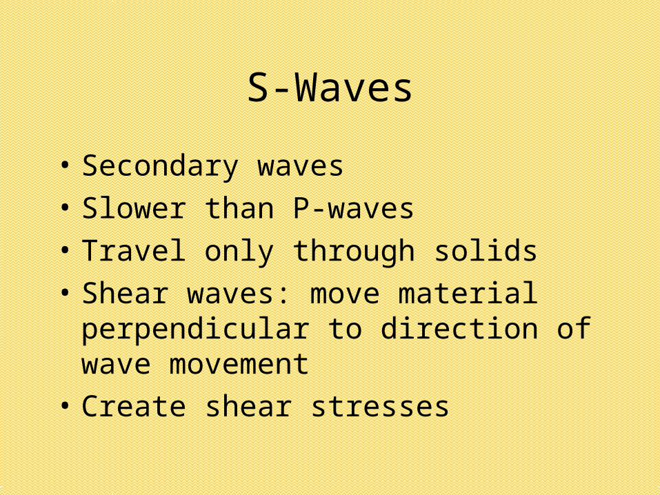
• Secondary waves
• Slower than P-waves
• Travel only through solids
• Shear waves: move material perpendicular to direction of wave movement
• Create shear stresses
S-Waves
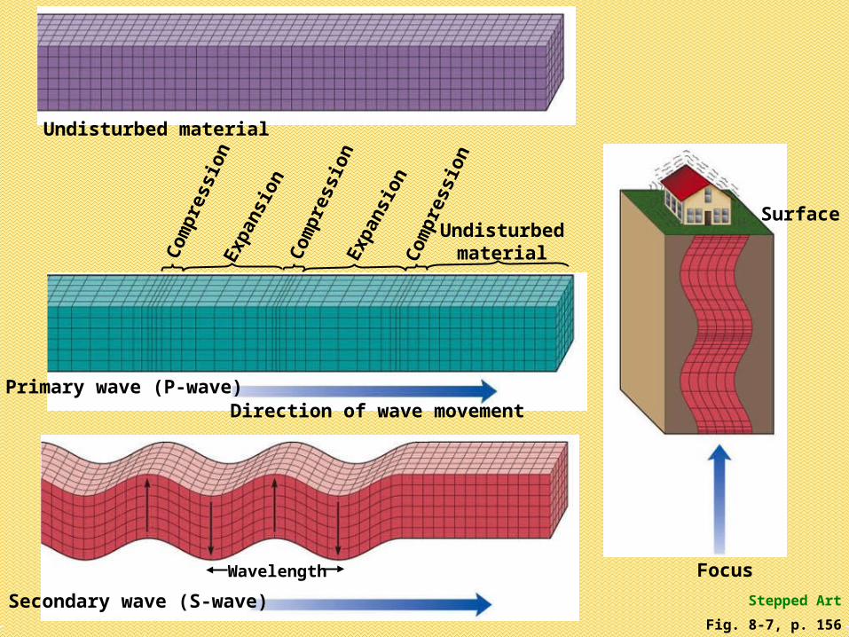
Fig. 8-7, p. 156
Undisturbed material
Focus
Surface
Primary wave (P-wave)
Com
pres
sion
Com
pres
sion
Com
pres
sion
Exp
ansi
on
Exp
ansi
on
Undisturbedmaterial
Direction of wave movement
Stepped ArtSecondary wave (S-wave)
Wavelength

• Travel at or just below the surface• Slower than body waves• R-waves (Rayleigh waves)
– Particles move in elliptical path, like water waves
• L-waves (Love waves)– Faster than R-waves– Particles move back forth in horizontal plane
perpendicular to direction of travel
Surface Waves

Fig. 8-8, p. 157
Love wave (L-wave)
Undisturbed material
Rayleigh wave (R-wave)
Rayleigh wave Love wave
Stepped Art

• P-wave and S-wave average speeds are known
• Time-distance graphs: difference in arrival time of the 2 waves vs. distance from focus
• The farther the waves travel, the greater the P-S time interval
• Epicenter can be determined when the P-S time intervals of at least three seismic stations are known
Locating an Earthquake


• Subjective measure of earthquake damage and human reaction
• Modified Mercalli Intensity Scale
• Maps with intensity zones
Earthquake Intensity

• Factors that affect earthquake intensity1. Size of earthquake
2. Distance from epicenter
3. Focal depth
4. Population density
5. Geology of area
6. Building construction
7. Duration of shaking
Earthquake Intensity, cont.


• Quantitative measure: amount of energy released
• Richter Magnitude Scale: total amount of energy released at earthquake source
• Measure amplitude of largest seismic wave
• Logarithmic: each whole-number increase is a 10-fold increase in amplitude, but a 30-fold increase in energy
Earthquake Magnitude


• Richter Magnitude Scale underestimates energy of very large quakes– Only measures peak energy, not duration
• Seismic-moment magnitude scale:– Strength of rocks– Area of fault rupture– Amount of movement of rocks adjacent to fault
• 1964 Alaska earthquake:– 8.6 Richter– 9.2 seismic-moment
Earthquake Magnitude, cont.

• Deaths, injuries, property damage:– Work or school hours– Population density– Magnitude– Duration– Distance from epicenter– Type of structures– Local geological characteristics
Earthquake Destruction

• Destructive effects:– Ground shaking– Fire– Seismic sea waves (tsunamis)– Landslides– Disruption of services– Panic and psychological shock
Earthquake Destruction, cont.

• Magnitude and distance• Underlying materials
– Poorly consolidated and water-saturated materials experience stronger S-waves
– Liquefaction: water-saturated sediments behave as a fluid
• Poor building materials: adobe, mud, brick, poorly built concrete
• Most common cause of fatalities/injuries
Ground Shaking


• Common in urban areas
• 1906 San Francisco earthquake– Severed electrical and gas lines – Fires spread throughout city– Water mains ruptured, so couldn’t put out
fires
• 1923 Tokyo earthquake– 71% of houses burned
Fire

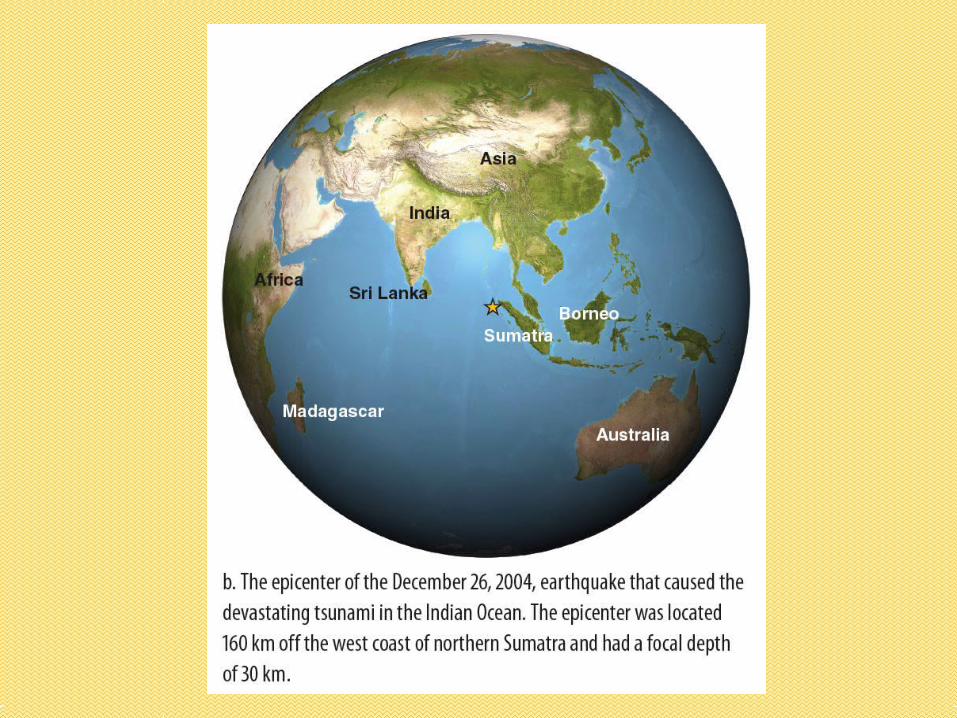
• Indian Ocean: 12/26/2004; 9.0
• Seismic sea wave, not tidal wave
• Caused by:– Submarine earthquakes– Submarine volcanoes– Submarine landslides
• Can travel across entire oceans
Tsunami

• Travel at ~600 mph
• Wave height less than 1 meter
• Wave length of several hundred miles
• Shallow water: wave slows and wave height increases
• 1946 Hilo tsunami: 16.5 m high
Tsunami, cont.

• Prior: sea withdraws, exposing the seafloor
• Pacific Tsunami Early Warning System– Seismographs– Instruments that detect seismic sea waves
• No warning system in the Indian Ocean
Tsunami, cont.

• Earthquake-triggered landslides
• Very dangerous in mountain regions
• Cause many deaths and much damage
• 1959 Madison Canyon slide
• 1970: Peru earthquake triggered avalanche that killed 66,000 people
Ground Failure


• Successful prediction must include:1. Time frame2. Location3. Strength
• Successful predictions are rare• Successful predictions would save lives• Seismic hazard maps help• U.S., China, Japan, Russia have
programs
Earthquake Prediction


• Plotting locations of earthquakes
• Locate seismic gaps on fault
• Slight changes in elevation
• Tilting of surface
• Water level fluctuations
• Changes in Earth’s magnetic field
• Electrical resistance of ground
Earthquake Precursors


• Prevention unlikely
• But may be able to gradually release energy stored in rocks
• Geologists can potentially inject liquids into locked segments and seismic gaps of faults to release small quakes; but could also cause a big quake
Earthquake Control


• Crust
• Mantle
• Outer core
• Inner core
Earth’s Interior


• P-wave and S-wave velocity determined by density and elasticity of material
• S-waves don’t travel through liquids
• Seismic waves change velocity and direction when enter material with different density or elasticity (refraction)
Seismic Waves and Earth’s Interior

• Some waves are reflected
• Calculate depths of boundaries
• Discontinuity: significant change in materials or their properties
Seismic Waves and Earth’s Interior, cont.


• P-wave velocity decreases at a depth of 2,900 km: core-mantle discontinuity
• P-wave shadow zone• Weak P-wave energy does penetrate the
shadow zone: from solid inner core• S-wave shadow zone: shows the outer
core is liquid, because S-waves can’t travel through liquids
The Core


• 16.4% Earth volume
• ~33% of mass
• Outer core: 9.9 to 12.2 g/cm3
• Earth center: pressure 3.5 million times of surface
• Outer core: iron, sulfur, silicon, oxygen, nickel, potassium
• Inner core: iron and nickel
Core Density and Composition

• Moho: discontinuity about 30 km deep• Asthenosphere:
– 100-250 km deep– P- and S-waves slow down– Plastic– Magma generation– Lithospheric plates ride across it
• 3.3 to 5.7 g/cm3; probably periodotite
Earth’s Mantle

Seismic Discontinuity Andrija Mohorovičić studied seismic waves and detected a seismic discontinuity at a depth of about 30 km. The deeper, faster seismic waves arrive at seismic stations first, even though they travel farther. This discontinuity, now known as the Moho, is between the crust and mantle.

• Geothermal gradient: 25ºC/km– Greater in active volcanic regions
• Most heat generated by radioactive decay
• Regions of equilibrium temperature• Base of crust: 800ºC to 1200ºC• Core-mantle boundary: 2,500ºC -5,000ºC
Earth’s Internal Heat

• Granitic composition
• 2.5 to 3.0 g/cm3; average = 2.7 g/cm3
• 20 to 90 km thick; average = 35 km thick
• Thickest under large mountain ranges
Continental Crust

• Gabbro overlain by basalt
• Average density = 3.0 g/cm3
• 5-10 km thick
• Thinnest at spreading ridges
Oceanic Crust