geol 452/552 - gis for geoscientists i basic arcgis...
TRANSCRIPT
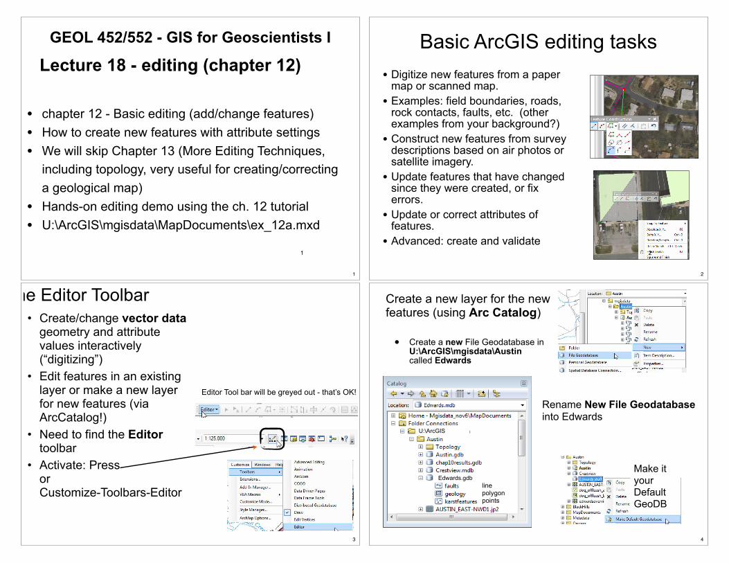
• chapter 12 - Basic editing (add/change features)• How to create new features with attribute settings• We will skip Chapter 13 (More Editing Techniques,
including topology, very useful for creating/correcting a geological map)
• Hands-on editing demo using the ch. 12 tutorial• U:\ArcGIS\mgisdata\MapDocuments\ex_12a.mxd
GEOL 452/552 - GIS for Geoscientists I
Lecture 18 - editing (chapter 12)
1
1
Basic ArcGIS editing tasks! Digitize new features from a paper
map or scanned map.! Examples: field boundaries, roads,
rock contacts, faults, etc. (other examples from your background?)
! Construct new features from survey descriptions based on air photos or satellite imagery.
! Update features that have changed since they were created, or fix errors.
! Update or correct attributes of features.
! Advanced: create and validate 2
2
• Create/change vector data geometry and attribute values interactively (“digitizing”)
• Edit features in an existing layer or make a new layer for new features (via ArcCatalog!)
• Need to find the Editor toolbar
• Activate: Pressor Customize-Toolbars-Editor
The Editor Toolbar
Editor Tool bar will be greyed out - that’s OK!
3
Create a new layer for the new features (using Arc Catalog)
• Create a new File Geodatabase in U:\ArcGIS\mgisdata\Austin called Edwards
U:\ArcGIS
Edwards.gdb
Rename New File Geodatabase into Edwards
Make it your Default GeoDB
linepolygonpoints
4

• Make a new feature class (“layer”) called faults inside the Edwards GeoDB• Set faults coordinate system to NAD 1983 Texas State Plane Central
!"#$%%&'(#)&*+,-(#./#01-&2+3%&#+3)#4&51-,613"
7"#89'12(#%112):3+(5(&9#*219#+31(<&2#-+;&2#=&">"#?3@:2139&3(+-#A#B&1-1>;C
D"#?3(&2#3+9&#+3)#*&+(,2&#(;'&"
E"#4:><(A%-:%F#>&1)+(+G+5&
H"#I2&+(&#J&-)5#+5#3&&)&)KL+9&K0&M(#J&-)DN#-&O&25#P:)&
5
What about Coordinate systems?
! ArcMap can edit across coordinate systems, e.g.:"GPS points layer file has unprojected GCS "Editing is performed in the data frame’s UTM and
converted on the fly"But: Edited GPS points are permanently stored in GCS
when edit mode is left.
?3(&2#BQR#'1:3(5#,5:3>#)&>2&&5#P:(<#(<&#)+(+#*2+9&(#(1#BIR"
UTMQ1:3(5#+2+@&)#:3#9&(&25#:3#(<&#J-&#P:(<#(<&#S0T#%112):3+(5(&9"
6
Start Editing mode
• Editor bar will get color (not be greyed out any more)• An new Window called Create Feature will appear• Create Feature shows the faults layer from the TOC• The Construction Tools part shows different Feature Templates - use
the simple Line for now
alone
7
The Editor toolbar
Alternative ways to the Editing Windows8
8

Feature templates! Feature templates store all info needed to
add a feature to a feature class.! They also have different construction tools
that can be used to create new features.
•#$%&'(&)#'*(+,'-.'//0#+%#,'1*'//0
•#$'1#2'3&#,*/-4/&#(&,4/'(&5#6+%#&'.2#/'0&%
•#$'1#'/5+#&1(&%#3'/*&5#71#'8%79*(&#:&/)5
9
The Edit tool;)7(#(++/
<2&#;)7(#(++/#75#*5&)#(+#5&/&.(#6&'(*%&5#5+#(2&0#.'1#9&#,+3&)=#)&/&(&)=#+%#&)7(&)>
?5&5#5('1)'%)#@&/&.(#A&'(*%&5#'1)#B$/&'%#@&/&.-+1#<++/5#CD'71#(++/#9'%=#&(.>E
# $/7.F#+1#6&'(*%&#(+#5&/&.(
# @27GB./7.F#(+#'))#'1+(2&%#6&'(*%&
# H%'I#'#9+J#'%+*1)#5&3&%'/#6&'(*%&5
# $/7.F#+1#&,4(0#54'.&#(+#./&'%#5&/&.-+1
# ?5&#$/&'%#@&/&.-+1
@&/&.(#A&'(*%&5
$/&'%#@&/&.-+1
10
10
Adding featuresU Choose template and construction toolU With edit tool, click inside map to create vertices
of a “sketch”U You can Zoom, pan, etc., resume sketch with U Double-click or F2 to “finish the sketch.”
Sketch in Progress
Freshly created Feature (even smells good ...)
Centroid
Automatically selected
Red = current
vertex
V-1+63>#T:3:#
(11-G+2
11
11
Editing context menus Sketch menu
Right-click outside sketch
Vertex menuRight-click on sketch (vertex,line)
12
12

Avoiding dangles
!"#$%&'(K(2&#(L+#/71&5#6'7/#(+#.+11&.(
)*++(,-"-*.*'*&/K(2+%7M+1('/#/71G(&%5&.(5#(2&%-.'/#+1&=#.%&'-1I#(2%&&#/71&5>
1+)&
N*(+,'-.'//0#.+11&.(5#6&'(*%&5#'1)#&15*%&5#/+I7.'/#.+1575(&1.0>##<L+#'44%+'.2&5#'%&#*5&)>
O>P&(#(2&%(&J#9/'.&)#'10L2&%&#'1)#.+%%&.(#7(#'G&%L'%)5>
Q>;15*%&#(2'(#3&%(&J#75#.%&'(&)#71#(2&#%7I2(#/+.'-+1>
13
I1';2:><(#W#DNEE#G;#T+2:G&(<#X"#Q2:%&
EDAD7
Setting snapping
14
14
Snapping
Correct topology—the horizontal line intersects the vertical one, creating three lines.
A dangle error — the two lines fail to physically connect
vertex
Automatically connects new point to existing point or line
Circle: Snap distance around mouse cursor
end point of line is dragged inside the
b
SNAP! snapped
15
15
Tolerance units
! Screen units"User sets the tolerance
as the number of pixels on the screen.
"Remains consistent regardless of the zoom level.
"Easy to work with at all scales
! D'4#*17(5"?5&%#5&(5#(2&#(+/&%'1.G#,'4#*17(5#C,&(&%5=#6&&(=#)&I%&&5E
" ;15*%&5#.+1575(&1(#4%&.757+1#'(#'//#5.'/&5
"D'0#9&.+,&#)7R.*/(#(+#L+%F#L7(2#L2&1#M++,&)#6'%#71#+%#6'%#+*(#6%+,#1+%,'/#&)7-1I#5.'/&
16

I1';2:><(#W#DNEE#G;#T+2:G&(<#X"#Q2:%&EDAEN
Types of snapping0%#"1%$..2%&
0#&("1%$..2%&
3(+-(4"1%$..2%&
?
!"#$$%"&'()*+,#"-+
+
5*2%-1%$..2%&
17
17
Saving work
6$7("($+'/8"1$7("*9(%:::
@(+45#&)7-1I#'1)#'5F5#(+#5'3&#'10#*15'3&)#&)7(5
@'3&5#'1)#.+1-1*&5#&)7-1I
18
I1';2:><(#W#DNEE#G;#T+2:G&(<#X"#Q2:%&
EDA7Y
The Sketch menu
$+1('715#6*1.-+15#6+%#'))71I#(2&J(#3&%(&JS
# 71#'#4'%-.*/'%#)7%&.-+1=
# L7(2#'#4'%-.*/'%#/&1I(2=
# 4'%'//&/#+%#4&%4&1)7.*/'%#(+#'#6&'(*%&=
# '(#'1#'1I/&#(+#'#6&'(*%&=#
# '(#'1#'1I/&#(+#'#5F&(.2#5&I,&1(=
# '(#'#54&.7:.#JB0#/+.'-+1>
19
19
• Temporary sketch for creating new features • Select layer to add feature to (target layer) and press pencil
button • You can use zoom, pan while sketching (click sketch button
again to go back)• Right-click: pulldown menu for context menus:
– On vertex: vertex menu – Not on vertex: sketch menu
• Double click to end sketch and create actual new feature (newly made feature will be selected)
• Click on Select tool (Black Arrow) exits sketch mode• Delete feature: Select - Hit Delete Key (Ctrl-Z Undo)
Sketching - summary
20

Edit Sketch Properties
T&%(&J#,&1*
?5&#(+#37&L#'1)U+%#&)7(#3&%(&J#.++%)71'(&5>
21
Attributes window
?5&6*/#L71)+L#6+%#&)7-1I#(2&#'8%79*(&5#+6#5&/&.(&)#6&'(*%&5>
R<1P5#(<&#%,22&3(-;#
5&-&%(&)#*&+(,2&5
?):(#(<&#+O2:G,(&5#1*#(<&#<:><-:><(&)#
*&+(,2&
?):(#(<&#+O2:G,(&5#<&2&
4:><(A%-:%F#:(&9#*12#%13(&M(#9&3,
22
Editing attributes
E"#I-:%F#(1#Z+5<#(<&#*&+(,2&#+3)#5&&#P<:%<#:(#:5"
D"#?):(#(<&#J&-)"
E"I-:%F#-+;&2#3+9&
D"#?):(#(<&#J&-)"
;)7(#'#571I/&'(*%& ;)7(#,*/-4/&'(*%&5
23
• Ch 12 Tutorial - 31• HW10 will be ex 1,2,3,4 extra 5 (due Nov 8)• Mini proj 2 questions?• Mini proj 3 questions?
Wrap up
24