geohydrology, geology, and soils of the cubango river ... · geohydrology, geology, and soils of...
TRANSCRIPT
Geohydrology, Geology, and Soils
of the Cubango River Basin
(Angolan Sector)
Specialist Report prepared by Etel Bereslawski :
PERMANENT OKAVANGO RIVER BASIN COMMISSION Angola Botswana Namibia Ministério da Energia e Águas Ministry of Mineral Resources and Water Affairs Ministry of Agriculture, Water and Rural Development GABHIC Department of Water Affairs Department of Water Affairs Cx. P. 6695 Private Bag 0029 Private Bag 13193 LUANDA GABORONE WINDHOEK
Tel: +244 2 393 681 Tel: +267 360 7100 Tel: +264 61 296 9111 Fax: +244 2 393 687 Fax: +267 303508 Fax: +264 61 232 861

Okavango River Basin Preparatory Assessment Study Specialist’s Report
Geohydrology, Geology, and Soils
of the Cubango River Basin
(Angolan Sector) Report prepared by : E. Bereslawski LUANDA Angola December 1997
Geohydrology, Geology and Soils; Angolan Sector
Okavango River Basin Preparatory Assessment Study Specialist’s Report
Table Of Contents
Page 1. INTRODUCTION 1 2. INSTITUTIONS VISITED 1 3. INFORMATION OBTAINED 2 3.1 General 2 3.2 Description of Documents Collected 3 4. CONCLUSIONS 16 5. MAIN RECOMMENDATIONS 18 6. CONCLUDING REMARKS 18 Tables 1 and 2; (followed by English translation) Annexures
Geohydrology, Geology and Soils; Angolan Sector

Okavango River Basin Preparatory Assessment Study Specialist’s Report
1. INTRODUCTION The purpose of this report is to provide a summary of the existing geohydrological information on the Cubango River Basin in the Republic of Angola. The information presented in this report was provided by various authorities including the National Directorate of Water (DNA), the Ministry of Geological and Mines, the University of Agostinho Neto (Geological department), and the Laboratory of Engineering. Information was also collected from reports in the Documentation Centres of these National Institutions. Other information included in this report was obtained from a number of articles published by the Junta de Ultramar, Lisbon, Portugal. During this assignment, it was found that there is little information on the Cubango River basin at any of the Documentation Centres visited. It was also clear that none of the Documentation Centres have been properly organised or updated for a long time. It is therefore difficult to identify and find the documents and reports required. After numerous visits to these Documentation Centres, in Luanda, several of the reports and articles on the Cubango river basin were found, dating back to between 1917 to 1976. They related to the following main topics; Hydrology, Geomorphology, Soils and Hydropower schemes. Very little information exists on the geohydrology of the Cubango River Basin due to the lack of investigations and groundwater research carried out, over the past 25 years in this southern region of Angola. For this reason, it was decided to widen the search to include the collection of hydrogeological information from the neighbouring hydrological basins. Some geohydrological articles and reports on the "Lower Cunene" region during 1950s and 1960s were discovered, and this information was considered to be an important contribution for this study. 2. INSTITUTIONS VISITED The following people and National Institutions relating to water resource aspects were visited: NATIONAL DIRECTORATE OF WATER (DNA) : Eng. Paulo Emilio (Chief of the Water Resources Department) Eng. Quaresma (Chief of the Hydraulics Department) Eng. Guillermo Távara (World Bank consultant) Documentation Centre located in the J. Pimenta Building. MINISTRY OF GEOLOGY AND MINES : Mr. Araujo (Director of the Institute of Geology and Mines) Mr. Paca Vira (Documentation Centre)
Geohydrology, Geology and Soils; Angolan Sector 1
Okavango River Basin Preparatory Assessment Study Specialist’s Report
MINISTRY OF AGRICULTURE AND RURAL DEVELOPMENT (MINADER) : Library UNIVERSITY OF AGOSTINHO NETO FACULTY OF SCIENCES, DEPARTMENT OF GEOLOGY : Dr. Eduardo Morais - Professor Library LABORATORY OF ENGINEERING : Eng. José Augusto Silva (Chief of the Geotecnics Department) LIBRARY OF THE PROVINCIAL GOVERNMENT OF LUANDA : UNICEF 3. INFORMATION OBTAINED 3.1 General As was pointed out earlier, there is very little information available on the groundwater resources of the Cubango River Basin. The following paragraph describes the situation during the 60’s and 70’s.
The Cubango River Basin flows through one of Angola’s least known and under-populated regions, known until now as" land at the end of the world" (terras do fim do mundo), Scheme of Water Resources Uses of Cubango river, Carlos Quinteira Gois, Lisbon 1973)
The search for hydrogeological information was largely carried out in the Ministry of Geology and Mines and in the Documentation Centre of the DNA. The most useful documents relating to different hydrological /hydrogeological aspects of the Cubango River Basin, were obtained from these two documentation centres. The most relevant data and information has been extracted from all these reports and summarized for inclusion in this report. Excerpts of the key texts, as well as some of the photographs, maps and tables have been photocopied and are included in the appendix (Annexes 1 and 2) A brief description of the key points found in each of the documents is provided in Table 1, as well as the date of compilation, author, tittle of the document, and location.
Geohydrology, Geology and Soils; Angolan Sector 2
Okavango River Basin Preparatory Assessment Study Specialist’s Report
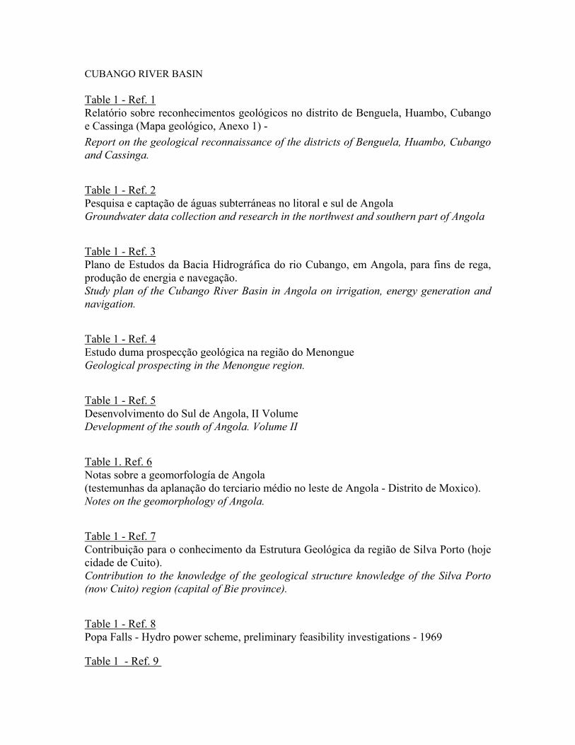
It should be stressed that all these documents were drawn up between 1917 and 1976. They include information and data on the following features of the Cubango River Basin - Water resources: analysis of the hydrological data, climatological and hydrometric data - Navigation : possibilities for the navigation in the Cubango river - Geomorphology - Soils ; Suitability of the Cubango River Basin's soils for agricultural purposes. - Water Resource Development : Identification of appropriate sites for the location of water resource development projects. From the discussions held with the DNA, it was clear that this institution has not undertaken groundwater research in the Cubango River Basin at any stage, and that they do not have any hydrogeological data for this region. However, it should be noted that the principal water supply system of Menongue's population (Capital of Cuando Cubango District) are the "cacimbas" (manually dug wells of 10 to 20 m depth). A large proportion of them were built during recent years. It was also pointed out that the "Hidrominas" national enterprise located in Lubango (province of Huila), devoted to hydrogeological research in the southern region of the country, has a complete file (but not yet computerised) of the hydrogeological data of a large number of boreholes drilled in the south of Angola since 1948. It is also necessary to refer to the most recent hydrogeological information prepared (1997) for the area covered by the Kalahari Sands in the south of Angola. This information was obtained from the conclusions of Project No 5 (Humpata 's project), "Water Resources study of the south-west region of Angola". This project was implemented by the Geological Department of the Agostinho Neto University and the Geophysics Section of the Italian Ministry for Cooperation. The project is part of the existing development plan of the South of Angola and was designed to study the groundwater resources of the southwestern region of the country. The Geological Map of Angola (1:1.000.000) compiled in 1988 is available from the Ministry of Geology and Mines in Luanda. 3.2 Description Of The Documents Collected The most relevant paragraphs of the majority of documents collected are included, as well as a brief comment of the principal characteristics of each of the documents analyzed. CUBANGO RIVER BASIN Table 1 - Ref. 1
Geohydrology, Geology and Soils; Angolan Sector 3

Okavango River Basin Preparatory Assessment Study Specialist’s Report
Relatório sobre reconhecimentos geológicos no distrito de Benguela, Huambo, Cubango e Cassinga (Mapa geológico, Anexo 1) - Report on the geological reconnaissance of the districts of Benguela, Huambo, Cubango and Cassinga. This report contains the description of the geological reconnaissance carried out between Huambo and Cassinga's towns, in 1917. The geological map compiled on the basis of this visit is included in Annex 1. The paragraph of most interest is: " From the 175 to 204 kilometre mark, there exist granites and granulites, as well as soils with slime and quartz. In the Calomba river, the soil consists of microgranites. Close to Ecucha river the soils include microgranites and in Cativa (also close to Ecucha river) there is one basic porphyries rock, the porphyry "labradorico", which shows crystals with a size of 3 to 4 cm. The augite shows significant signs of decomposition; and from here on metamorphic formations can be found such as "gneiss's amphibolicos" nearby the Mission Station. The Cubango river shows this type of rock which originates in the north. Between Cubango and Cassinga the soil is formed from granites and gneiss and close to the Ulonda river in a big area we have slime (??)”. Table 1 - Ref. 2 Pesquisa e captação de águas subterráneas no litoral e sul de Angola Groundwater data collection and research in the north-west and southern part of Angola This document was compiled in 1951. It includes the annual isohyetal map of the country, one colour map of the phytogeografic areas of Angola, and another map showing the hydrogeological research carried out and programmed in the south of Angola. It includes a brief description of the different water abstraction methods used in southern Angola. Unfortunately, no hydrogeological information is available on the Cuando Cubango District. Table 1 - Ref. 3 Plano de Estudos da Bacia Hidrográfica do rio Cubango, em Angola, para fins de rega, produção de energia e navegação. Study plan of the Cubango River Basin in Angola on irrigation, energy generation and navigation. This document was prepared in 1953/54, and presents the following hydrological information (Annex 1): -Data series with a maximum of 12 years of annual rainfall records..
Geohydrology, Geology and Soils; Angolan Sector 4

Okavango River Basin Preparatory Assessment Study Specialist’s Report
-Climatological data (temperature, humidity) from the climatological station of Chitembo, period 1944/1952. -Annual evaporation data for Artur de Paiva (Cuvango) and Serpa Pinto (Menongue) stations. -Hydrometric data at Mohembo (Okavango River in Botswana) This document includes several photographs of the Cubango river. The annual isohyetal maps presented in this document are not of major interest, as they are based on a very short series of precipitation data. Table 1 - Ref. 4 Estudo duma prospecção geológica na região do Menongue Geological prospecting in the Menongue region. This is a short geological description from the mineralogy point of view, and includes names of the principal minerals identified in this region. Table 1 - Ref. 5 Desenvolvimento do Sul de Angola, II Volume Development of the south of Angola. Volume II This document was compiled in 1963, and includes a complete description of the natural resources in the South of Angola: District of Moçamedes (today Namibe), Huila and Cuando Cubango. Since it was produced 34 years ago, most of the information, such as population data, number of schools, types of economic activity etc are outdated. Nevertheless, it contains useful data and interesting information relating to geology, mining resources, hydrology, hydrogeology, climatology, environmental aspects, soils, fauna etc. From the water resources chapter: " In the south of the Huila district, as a result of the absence of any permanent water course except that of the Cunene river, a large number of well drillings have been carried out, either in the crystalline rocks or in the Kalahari sediments. In general, the majority of groundwater investigations carried out were successful. In wells with an average depth of 30 m depth built either in the granite or gabro-anorthosítica rocks, maximum yields of 15.000 l/h were obtained. Groundwater investigations in the Kalahari sediments were less successful, due to the low permeability values, and particularly when a considerable sediment thickness exists.
Geohydrology, Geology and Soils; Angolan Sector 5
Okavango River Basin Preparatory Assessment Study Specialist’s Report
It was verified that when the Kalahari sediments contact crystallite rocks at a conglomerate formation it is possible to find water, either in the first part of the altered and fractured crystalline rock or in the conglomerate formation when its shows an adequate permeability value. Groundwater yields rise up to 10.000 l/h. With regard to the Cuando Cubango District, no data and information are available. Nevertheless, this does not seem to be a problem, since there are permanent water courses." Table 1. Ref. 6 Notas sobre a geomorfología de Angola (testemunhas da aplanação do terciario médio no leste de Angola - Distrito de Moxico). Angola's geomorphologic notes. Scientific article issued by the Garcia da Orta editions, carried out in the " Tropical Pedology study centre of Lisbon" . It describes the different morphological units of the Moxico District (Annex 1) in Angola. The most interesting paragraphs are those relating to the geomorphological description of the Cuito river area: "a) The western sandy, plateau area with shifting relief This geomorphologic unit was formed by shifting relief (relevo movimentado) made up of different plateaux whose altitudes decrease slowly from west to east and from north to south. Within the climatic conditions, the morphologic features of this relief are characterised by its lithology. The lithology is formed by sand deposits of wind-blown origin which in some areas are 200m thick. The erosive action of Cuito and Cuando rivers over this sandy formation forms has formed deep valleys with long planes, seldom with swampy bottoms, but with quite steep slopes (often 15 %). The plateau summit is horizontal with dense vegetation of medium height. Summing up: the stream network, due to its erosive nature, has quickly incised into the topography due to the erosive character of the rock. For this reason the polymorfic-sandstone has been eroded away leaving dolerite outcrops. At some points basement complex or rocks of the Karoo series can be seen. The part of the Cubango river basin included in this study is the Cuito river. The Cuito river and its tributary, Cuanaval, runs in approximately a north-south direction, parallel to the Cuando river in the western area of the Moxico region.
Geohydrology, Geology and Soils; Angolan Sector 6

Okavango River Basin Preparatory Assessment Study Specialist’s Report
In conclusion, the principal facts to be noted are: i) The Cuito, Cuando, Luanguinga, Lungué, Bungo, Luena and Cassain rivers have their
origins in the same morphological unit, i.e. the sandy plateau area with shifting relief ii) The principal importance of the Atlantic Ocean hydrography network in comparison with
the Indian Ocean hydrography network, is that in the Cameia region, where the east-west divide is to be found, being on the edge of the left-most tributary of the Zaire River. (Cameia River).
iii) The Cuando river may have captured the streams having a NNW-SSE direction and a N-S
direction which may at one stage have belonged to the Cubango River system. iv) Finally, the balance to the north of the tertiary flattened (aplanação do terciario) area
appears not to have great influence on the actual hydrography network of Moxico region, and from this it can be concluded that these rivers could have been formed later than the sandy formation of the high plateaux.
Table 1 - Ref. 7 Contribuição para o conhecimento da Estrutura Geológica da região de Silva Porto (hoje cidade de Cuito). Contribution to the knowledge of the geological structure of the Silva Porto region (now Cuito) capital of Bie province). Article issued by García da Orta technical editions in Lisbon. It describes all the conglomerate formations of the Cuito River Valley. The article has the following summary : "Conglomerate formations occur in the Cuito Valley between Silva Porto and Silva Porto-Gare, at an elevation of 1650 m. The observation of new geological formations seems to show:
1) there exists a conglomeratic formation of glacial origin overlying gneisses of the Basement Complex;
2) over this formation there is a relatively deformed schist clay-sandstone complex; 3) this complex is covered by another conglomerate formation, coarse on the base and
fine on top.
These formations allow the following hypothesis: With respect to the evolution of the local relief: after formations 1) and 2) had covered the Basement Complex a local depression would have occurred with the formation of an inner
Geohydrology, Geology and Soils; Angolan Sector 7
Okavango River Basin Preparatory Assessment Study Specialist’s Report
basin, which was later filled by relief erosion. If these observations are proved to be correct and once the chronology of the geological formations is established, the date of the planation that levelled formation 3) with the Basement Complex and, consequently the date of the lower planations that occur on the Angolan Antique Plateau can be determined. Table 1 - Ref. 8 Popa Falls - Hydro power scheme, preliminary feasibility investigations - 1969 This document was prepared in 1960 by the Department of Water Affairs, South Africa. This report presents a preliminary feasibility study of the Popa Falls dam which was planned for the Okavango River, just a few kilometres to the south of the Angola and Namibia border. Table 1 - Ref. 9 Esquema do aproveitamento hidraúlico da bacia do rio Cubango. Estudo hidrológico Utilization scheme for the basin of the Cubango River. Hydrology study. Data included in this report are: • Annual precipitation; 1943/44 - 1966/67 (several stations) • Statistical study of annual precipitation. • Monthly runoff and flows of the Cubango river at the following stations: -Chinhama (Lat. 13º 03'S, Long 16º 07'E; 1.799 km2) 1963/64 - 1966/67 -Artur da Paiva (Lat. 14º 28'S Long 16º 07'E; 7.185 km2) 1963/64 - 1966/67 -Caiundo (Lat 14º 22'S, Long 16º 30'E; 38.486 km2) 1957/58 - 1966/67 -Mucundi (Lat 16º 13'S, Long 17º 41'E - 50.135 km2) period 61/62 - 66/67 -Runtu , 1946/47 - 1966/67 -Sambio, (Lat 17º 53'S, Long. 20º 04'E; 84 368 km2) 1963/64 - 1966/67 • Monthly flows and runoff in the Cutato river at: -Cutato (Lat 14º 22'S, 16º 30'E; 3.683 km2) 1963/64 - 1966/67 • Monthly flows and runoff in the Cuchi river at: -Cuchi (Lat 14º 39'S, 16º 54'E; 9.214 km2) 1963/64 - 1966/67 • Monthly flows and runoff in the Cualei river at: -Cuelei (Lat 14º 41'S, Long 17º 22' E; 1.390 km2) • Monthly flows and runoff the Luauca rRver at: -Serpa Pinto ( Lat 14 º40' S, Long 14 º 41' E; 976 km2) 1964/65 - 1966/67 • Monthly flows and runoff in the Cuebe river at:
Geohydrology, Geology and Soils; Angolan Sector 8

Okavango River Basin Preparatory Assessment Study Specialist’s Report
-Serpa Pinto II (Lat 14º 40' S, Long. 14º 41'E; 1.340 km2) 1961/62 - 1966/67 -Capico (Lat 15º32'S, Long 17º 35'E; 9.758 km2) 1964/65 - 1966/67 • Monthly flows and runoff in the Lussinga river at: -Lussinga (Lat 14º 35 'S, Long 18º 10'E; 575 km2) 1964/65 - 1966/67 • Monthly flows and runoff in the Longa river at: -Longa (Lat. 14º 36'S Long 18º 28'E; 1.122 km2) 1964/65 - 1966/67 • Monthly flows and runoff in the Cuiriri river at: -Cuiriri (Lat 14º 41'S, Long 18º 40'E; 1.769 km2) 1964/65 - 1966/67 • Monthly flows and runoff in the Cuito river at: -Cuito (Lat 15º 07'S Long 19º10'E; 15.193 km2) 1965/66 - 1966/67 -Cuito Cuanavale (Lat 15º 10'S, Long. 19º11'E; 22.198 km2) 1966/67 -Ponto de Passagem (Lat 15º 40'S, Long 19º 10'E) 1963/64 - 1966/67 • Peak floods statistical analysis at the Rundu station. • Monthly evaporation data (open water surface, several stations) • Annual isohyetal maps of the Cubango basin • Several graphs relating to monthly flow records. Table 1 - Ref. 10 Esquema do desenvolvimento dos recursos hídricos da bacia do rio Cubango The Water Resources Development scheme of Cubango's river (Annex 1) The Water Resources Development Scheme of Cubango river was compiled in 1973, and consists of five volumes. Each volume comprises: • General description (Table 1 - ref. 10) • Designs (located in DNA library) • Hydrological study (Table 1 - ref. 9) • Agronomic study (Table 1 - ref. 11) • Geological study (not located) In volume one, several sites for the construction of surface water resource works were defined. It clearly identified 22 sites for the location of dams to be used for water resources regulation and energy production purposes. The paragraphs of main interest are: Geology chapter:
Geohydrology, Geology and Soils; Angolan Sector 9

Okavango River Basin Preparatory Assessment Study Specialist’s Report
From observations, it was found that three groups of rocks are present in this basin. The igneous and metamorphic are located in the region with most pronounced relief , in the north-east part of the basin, the sedimentary rocks are found in the flat area, located in the north-east, and in the south, (i.e. the remainder of the Cubango river basin.) Igneous rocks occupy are to be found in some parts of the north-eastern region. They inlcude:
ante-permic formations, which generally includes, granites, porphyries and prophyrites, and a little portion of sienitos located in the Northeast of Arthur da Paiva town. Un-dated "ante- cambric formations", continued by granites granodiorites and quartzodiorites, and in the Arthur da Paiva region (now Cuito), a small portion of dolerites.
Metamorphic rocks occur close to the north-east limit of the basin, and they are represented by Basement Complex, and are made up of various gneisses, metamorphic xistos, quartzite's, xistos quartzite's and crystalline calcareous. The metamorphic formation from the superior group of Oendolongo system look similar to igneous rocks. They are dispersed in small pockets, and are found in the form of weak metamorphic rocks with banded ironstone (principally) , and quartzites, sandstone crossed by felsites and porphyric dikes. Sedimentary formations form the majority of the basin. Geologically they characterize the Cubango river basin, and dictate the water course regime and economic potential of this region.
These formations are the Kalahari superior formations from the Pleistocene and more recent ones, essentially sandy with some levels of gravel and lateritic deposit overlaying polimorphyc sandstone, quartzite's, sandstone and milicificados (?) calcareous from the lower Kalahari formation.
Relating to the water supply system found in the Cubango river basin:
“…The uniform distribution of the stream channel network together with the good water quality and the permanency of the main water courses has allowed the establishment of an simple water system supply based on a pumping system from the water course, followed by a distribution water system with a complexity related to the number of inhabitants supplied. In some extreme cases when this water supply system is not possible, (esssentially in the arid region of the south of the basin between Cuito and Cubango rivers), the population has been supplied by "cacimbas" (manually dug wells).
Table 1 - Ref. 11
Geohydrology, Geology and Soils; Angolan Sector 10

Okavango River Basin Preparatory Assessment Study Specialist’s Report
Recursos en terras com aptidão para o regadío na Bacia do Cubango Suitability of the Cubango basin’s soils for irrigation purposes Document drawn up in 1973 by the Agronomic Investigation Institute of Angola, and contains a detailed inventory of the Cubango basin’s soil suitability for irrigation. Ten maps were included (1:100.000) showing the suitable irrigatible soils which are located along the Cubango and Cuito rivers. The coloured maps were well detailed and well presented. Also included were some black and white photographs showing different soil types, and one black and white Pedology Map of Angola (1:2.5000.000) which was drawn up from the Pedology schemes carried out by the Pedology team working in Angola and Mozambique at that time. Table 1 - Ref. 12.13 Plano de Coordenação para o abastecimento de água ás regiões pastoris do Sul de Angola. Co-ordination plan for water supply to the cattle regions of the south of Angola Estudos hidrogeológicos e Aproveitamento de águas. Relatório da execução 1973. Plano de Coordenação para o abastecimento de água as regiões pastoris do Sul de Angola. Hydrogeological studies and water research. Completed work reports from 1973, Co-ordination plan for the water supply to the cattle regions of the south of Angola. Both these reports were produced between 1954 and 1973, and describe the groundwater surveys carried out in the south of Angola by the Hydrogeological team (brigade) of the Angolan Ministry of Geology and Mines. These documents represent the only source of hydrogeological information available in Luanda, relatng to the groundwater surveys carried out during the 20 year period of 1954 - 1973) in the south of the country, and include the Cuando Cubango District. The most relevant information presented in these documents are: names of the wells built, groundwater yields (flow rate obtained), human and material resources in charge of this work. These documents do not contain much hydrogeological information, due to the lack of information on well localisation or geological data, as well as to the absence of any technical data relating to successful boreholes. Courtesy of Mr Paca Vira, from the Centre of Documentation of the Ministry of Geology and Mines, it was possible to examine a large number of hydrogeological annual reports (1958 - 1973) with information on the hydrogeological surveys carried out in the south of Angola. The following table, drawn up from these reports, summarizes some characteristics of the boreholes drilled in the Cuando Cubango District.
Geohydrology, Geology and Soils; Angolan Sector 11
Okavango River Basin Preparatory Assessment Study Specialist’s Report
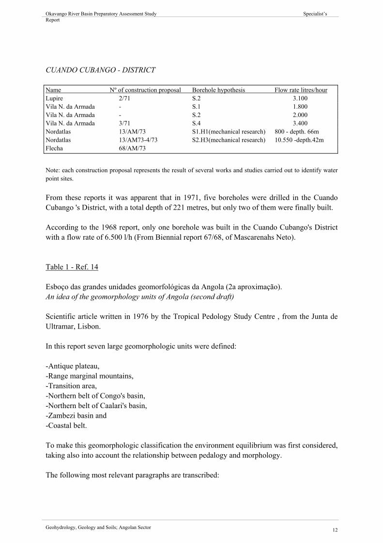
CUANDO CUBANGO - DISTRICT
Name Nº of construction proposal Borehole hypothesis Flow rate litres/hour Lupire 2/71 S.2 3.100 Vila N. da Armada - S.1 1.800 Vila N. da Armada - S.2 2.000 Vila N. da Armada 3/71 S.4 3.400 Nordatlas 13/AM/73 S1.H1(mechanical research) 800 - depth. 66m Nordatlas 13/AM73-4/73 S2.H3(mechanical research) 10.550 -depth.42m Flecha 68/AM/73
Note: each construction proposal represents the result of several works and studies carried out to identify water point sites. From these reports it was apparent that in 1971, five boreholes were drilled in the Cuando Cubango 's District, with a total depth of 221 metres, but only two of them were finally built. According to the 1968 report, only one borehole was built in the Cuando Cubango's District with a flow rate of 6.500 l/h (From Biennial report 67/68, of Mascarenahs Neto). Table 1 - Ref. 14 Esboço das grandes unidades geomorfológicas da Angola (2a aproximação). An idea of the geomorphology units of Angola (second draft) Scientific article written in 1976 by the Tropical Pedology Study Centre , from the Junta de Ultramar, Lisbon. In this report seven large geomorphologic units were defined: -Antique plateau, -Range marginal mountains, -Transition area, -Northern belt of Congo's basin, -Northern belt of Caalari's basin, -Zambezi basin and -Coastal belt. To make this geomorphologic classification the environment equilibrium was first considered, taking also into account the relationship between pedalogy and morphology. The following most relevant paragraphs are transcribed:
Geohydrology, Geology and Soils; Angolan Sector 12

Okavango River Basin Preparatory Assessment Study Specialist’s Report
"V Northern belt of Kalahari's basin:
This is a geomorphologic unit whose relief is influenced by the Namibe endorreic's basin evolution. Three sub-units were considered:
a) Endorreic depression of Cuvelai-Lueque, the flattening (aplanação) medium tertiary's residual region, covered by thick windy sandy deposits, accepting that it constitutes a recently stabilised region, from this reason it could be accepted that an equilibrium in the pedogénese/morfógenese relation exists. b) Cubango's basin, this is a similar region to the other one a) although it was probably stabilised long time before, as it seems to be because the pedogénesis predominance over the morfogenesis. c) Cunene's depression - depressioned area influenced by the antique quaternary Cunene's capture to the Atlantic Ocean, this region is considered as "intergrade" region.
In the geomorphological map of Angola included in the article, the three geomorphologic areas were well identified, and it indicated that the Cuvelai -Lueque area belongs to the region delimited by the Cunene and Cubango's rivers, usually referred to as the "Lower Cunene region".
1º Encontro da Cooperação Universitária - Italo - Angolana- Universidade Agostinho Neto. Luanda 1997 First meeting of the Italo-Angolan University Co-operation. University of Agostinho Neto, Luanda 1997 Mr. Morais, from the Faculty of Science, Department of Geology, made it clear that it had been impossible to carry out any hydrogeological research in the Cubango River Basin over the past 20 years due to the difficulties existing within the institution (budget difficulties, lack of qualified personnel, etc.) and because of the security problems in this region over the past 20 years. Mr. Morais recommended that the conclusions derived in the " Project 5, Water Resources study of the south-east region of Angola" could be used as a guideline for any future hydrogeological study to be carried out in the Cubango area. The most important conclusions from the this study related to the Kalahari area:
"In 1994,95,96 three geophysical missions took place in the south-western region of Angola, the principal purpose was to identify new water supply sources, and to define the most appropriate methodology for the hydrogeological surveys according to the aquifer's characteristics. It should be remembered that Hidrominas and UNICEF also participated in these hydrogeological research studies.
Geohydrology, Geology and Soils; Angolan Sector 13
Okavango River Basin Preparatory Assessment Study Specialist’s Report
On the bases of the different aquifers’ typology in this region, four areas were therefore defined: Namibe, Lubango-Humpata, Chiange and Kalahari. The vertical electric and the electromagnetic methods were chosen for the aquifers in tectonized areas and the seismic vertical (refraction/reflection) method in the contacted and fractured aquifers (aquíferos de contacto e fracturação) with sedimentary porous bodies and altered surface.
In the Kalahari area, where the Gabro-anortosítico complex of rocks are covered by neogénico-quaternary continental deposits and are hundreds of meters thick, it was firstly recommended to use the seismic refraction-reflection method, and secondly to use the seismic vertical electrical method as a support method, to identify the porous and saturated water levels inside the continental formations."
LOWER CUNENE REGION During the hydrogeological research process it was clear that the Lower Cunene region has been widely studied, and that various hydrogeological surveys have been carried out since 1951. The lower part of the Cunene region is situated between the Cunene and Cubango rivers, inside the Kalahari northern belt, and shows very similar geological and geomorphologic characteristics to those of the Cubango river basin (Monteiro Marques article, Angola main geomorphologic units. Ref. 14). Several geohydrological research studies were carried out between 1950 and 1976 (Table 2, Ref.1, Ref 2) due to the absence of permanent water courses, taking into account the water supply demands as well as the water requirements for the numerous herds of cattle that used to be in this region. As a result of these studies, a considerable number of hydrogeological reports were written. The complete borehole data are included in these reports, as well as relevant information such as geological profile, flow rate, groundwater chemistry, geological schemes, general hydrogeological behaviour of the various aquifers existing in this region. The article "The hydrogeology and the water supply problem of the Lower Cunene region" written by Carlos Neves Ferrao, in 1961 synthesises and summarises the information gathered from all those reports. The following hydrogeological conclusions have been drawn from this article: Table 2 - Ref .3 A Hidrogeologia e o problema de Abastecimiento de Agua ao Baixo Cunene
Geohydrology, Geology and Soils; Angolan Sector 14

Okavango River Basin Preparatory Assessment Study Specialist’s Report
The Hydrogeology and the Water supply problem of the Lower Cunene region. The Lower Cunene region is located in the extreme north-west of the Kalahari interior basin, and belongs to the Ovambolândia depression, limited to the south by the Otavi axis. The whole region constitutes a vast plain delimited by the Cunene and Cubango rivers. It shows a smooth and apparently uniform slope, with north-south direction, close to 50 cm/km. The altitude in the northern area is approximately 1.200 m and in the south 1.130 m. The annual precipitation decreases progressively from the north (900 mm) to the south (528 mm). The Water Resources balance carried out according to the Thornthwaite method, considering 100 mm as the soil storage capacity, demonstrated that the Lower Cunene Region is characterised by a marked water deficiency which increases gradually from north to south. The Lower Cunene region is occupied by typical continental sediments from the Kalahari formations. Its maximum depth is unknown. The deepest borehole drilled in this region, was 210m deep without exceeding the sand and sandstone area. The sandstone thickness plays a very important role in the groundwater occurrence (development). Only big storms result in a rise of the groundwater table level. In the northern part of the region it was noted that the rains caused a rise of the water table levels, even during the years of low precipitation. The groundwater mineralisation shows lateral and deep variability. Taking into account that the flow velocity is very low, it can be accepted that the mineralisation increases from the north to the south. Nevertheless, it is evident that the mineralisation reflects the aquifer's composition and nature of its sediments. Data on evaporation recorded in superficial wells (depth of less than 10m) during 1951 to 1955, showed an average of 100 mm/day or sometimes more. Measurements of the water table, carried out at the same time, verified that the water level decreases more quickly when the levels of evaporation are high. It was also verified that the water levels could decline by 50cm per month. It is relatively easy to identify the water table in the superficial sands. Its occurrence depends on the existence of the sandstone layer as well as its thickness, which in general does not exceed 6m in deep. The best indicator of the existence of these freatic waters (water table) is the fact that thousands of "cacimbas" were built in this region by the local people. Due to the irregularity of the shallow artesian aquifers as well as the type of mineralisation, in some cases it is necessary to carry out several drillings before deciding on the most appropriate site for the construction of the borehole.
Geohydrology, Geology and Soils; Angolan Sector 15
Okavango River Basin Preparatory Assessment Study Specialist’s Report
Deep artesian water: Nothing is known relating to the nature and depth of the sediments bed. From the boreholes drilled of hundreds of meters in depth, it was verified, that the sands are wet and are submitted to large pressures, which gradually increase in depth. The Geological and Mine's team drilled 478 boreholes. A large proportion of them were installed for hydrogeological surveys, and the others for hydrological observations and water resources research. The flow rates obtained were between 150 l/h to 10.000 l/h. In general flow rates of less than 5.000 l/h could be expected. The results from the borehole water samples collected, showed that they are of good chemical quality. Some plant species such as : Ficus hererorensis, Ficus thonningii and Diospyros mespiliformis are important from the hydrogeological point of view. The latter’s roots penetrate deep into the soil and sometimes reach the artesian aquifer. This is an rare situation and may be a unique example of a plant that can indicate the existence of groundwater. 4. CONCLUSIONS On the basis of what has been outlined in this report, it can be concluded that:
The bibliographic/literature search work in Luanda is a very difficult task, as the majority of the Documentation Centres have serious budget difficulties, lack of qualified people and have therefore been practically abandoned. The existing reports and documents are not easily classified and in general it takes a considerably amount of time to locate the required documents.
All the documents collected for the writing of this report, were produced between 1917 and 1973. No hydrogeological studies have been carried out for the past 20 years in the Cubango River Basin. The only data collected show that in the few boreholes in the Cubango basin, during the 1970’s, with depths of approximately 40m - 60m, flow rate production/yield is between 10.000 m3/h and 15.000 m3/h People have been constructing a large number of cacimbas (manually dug wells, 15m - 20m deep) as it is the most commonly used system for supplying drinking water all year round. the year From the geological study carried out in 1973, it was verified that the three large groups of rocks are present in the Cubango river basin: igneous and metamorphic rocks located in the north-eastern part of the basin and the sedimentary rocks present in the plateau areas,
Geohydrology, Geology and Soils; Angolan Sector 16
Okavango River Basin Preparatory Assessment Study Specialist’s Report
located in the north-east and southern regions. They are the Kalahari superior formations from the Pleistocene age as well as more recent ones, essentially sandy with some levels of gravel and lateritic deposit overlaying polimorphyc sandstone, quartzites, sandstone and milicificados (?) calcareous from the lower Kalahari. Due to a lack of data on the Cubango basin, it was decided to collect geohydrological data from the nearby region of Cunene as well. From the geohydrological studies carried out in the Lower Cunene region, between 1951 and 1960, the following conclusions were reached:
i) Only the "major storms" cause a rise in groundwater levels. ii) Annual evaporation levels are very high, and in general are five times that of the annual
precipitation.
iii) In the Kalahari region it would be possible to find sand and sandstone substratum of more than 200 m in thickness
. iv) No studies have been carried out on the artesian aquifers. v) The flow rates obtained from the any of the 278 boreholes constructed in this region
were always less than 10.000 l/ h. vi) The water samples analysed from wells of 200m in depth, show a mineralisation less
than 600 mg/l, and are of good quality. vii) It is relatively easy to identify the water table in the superficial sands. Its occurrence
depends on the existence of the sandstone layer as well as its thickness, which in general does not exceed 6 metres in deep. The best indicator of the existence of this phreatic waters (water table) is the fact that thousands of "cacimbas" were built in this region by the local people.
5. MAIN RECOMMENDATIONS Taking into account the above conclusions, it is therefore necessary to add the following recommendations: The geohydrological data of the Cubango River Basin in Angola is practically non existent.
Geohydrology, Geology and Soils; Angolan Sector 17

Okavango River Basin Preparatory Assessment Study Specialist’s Report
The present literature search shows that the most relevant documents available in Luanda, from the geohydrological point of view are:
i) Geological map of Angola (1: 1.000.000) ii) Annual reports produced by the "hidrogeological brigade in the south of Angola", from
1950 to 1973. iii) Investigations carried out together by the Geological Department of the Angolan
Sciences Faculty and the Italian Co-operation in the Cunene region. The lack of hydrogeological information is due to the absence of investigations carried out during the past 20 years, and also due to the loss of a number of documents and reports from the different Centres of Documentation. With the purpose of having at least a general point of view relating to the geohydrolgical aspects of the Cubango River Basin, and in order to properly prepare and organise future hydrogeological research in this area, it is highly recommended to collect more data and geohydrological information on the Cubango basin.. With respect to the above consideration, it is recommended to programme a "bibliographic/literature search mission" in the different Portuguese institutions which have been collaborating on the various studies carried out during the colonial period in the south of Angola. These include the "Junta de Investigaciones de Ultramar" and the "Laboratorio Nacional de Ingeniería civil de Portugal ". It is also recommended to undertake a "geohydrological mission" to the "Hidrominas" in Lubango, with the aim of locating more hydrogeologic information (geological profiles, groundwater chemistry data, aquifer information, etc.) relating to the boreholes constructed over the past decades in the Cubango District. 6. CONCLUDING REMARKS From the analysis of this report, it can be concluded that the quantity and quality of information collected does not totally represent the time and effort invested. Therefore it is necessary to note again that during the development of this mission in Angola, a large number of people and institutions were visited, but because of the reasons noted in this report, i.e. lack of material and human resources, budget constraints in all the national institutions, as well as the lack of hydrological studies carried over the past 25 years, it was impossible to obtain more hydrogeological information and data on the Cubango River Basin. It is the desire of this consultant that all the information included in this report, as well as the main recommendations, could contribute to a better knowledge of the hydrogeological characteristics and behaviour of the Cubango River Basin, and could be a useful tool for
Geohydrology, Geology and Soils; Angolan Sector 18
Okavango River Basin Preparatory Assessment Study Specialist’s Report
deciding on the most appropriate methodology to be used in futures studies for this southern region of Angola.
Geohydrology, Geology and Soils; Angolan Sector 19
CUBANGO RIVER BASIN Table 1 - Ref. 1 Relatório sobre reconhecimentos geológicos no distrito de Benguela, Huambo, Cubango e Cassinga (Mapa geológico, Anexo 1) - Report on the geological reconnaissance of the districts of Benguela, Huambo, Cubango and Cassinga. Table 1 - Ref. 2 Pesquisa e captação de águas subterráneas no litoral e sul de Angola Groundwater data collection and research in the northwest and southern part of Angola Table 1 - Ref. 3 Plano de Estudos da Bacia Hidrográfica do rio Cubango, em Angola, para fins de rega, produção de energia e navegação. Study plan of the Cubango River Basin in Angola on irrigation, energy generation and navigation. Table 1 - Ref. 4 Estudo duma prospecção geológica na região do Menongue Geological prospecting in the Menongue region. Table 1 - Ref. 5 Desenvolvimento do Sul de Angola, II Volume Development of the south of Angola. Volume II Table 1. Ref. 6 Notas sobre a geomorfología de Angola (testemunhas da aplanação do terciario médio no leste de Angola - Distrito de Moxico). Notes on the geomorphology of Angola. Table 1 - Ref. 7 Contribuição para o conhecimento da Estrutura Geológica da região de Silva Porto (hoje cidade de Cuito). Contribution to the knowledge of the geological structure knowledge of the Silva Porto (now Cuito) region (capital of Bie province). Table 1 - Ref. 8 Popa Falls - Hydro power scheme, preliminary feasibility investigations - 1969 Table 1 - Ref. 9
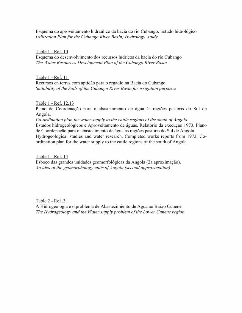
Esquema do aproveitamento hidraúlico da bacia do rio Cubango. Estudo hidrológico Utilization Plan for the Cubango River Basin; Hydrology study. Table 1 - Ref. 10 Esquema do desenvolvimento dos recursos hídricos da bacia do rio Cubango The Water Resources Development Plan of the Cubango River Basin Table 1 - Ref. 11 Recursos en terras com aptidão para o regadío na Bacia do Cubango Suitability of the Soils of the Cubango River Basin for irrigation purposes Table 1 - Ref. 12.13 Plano de Coordenação para o abastecimento de água ás regiões pastoris do Sul de Angola. Co-ordination plan for water supply to the cattle regions of the south of Angola Estudos hidrogeológicos e Aproveitamento de águas. Relatório da execução 1973. Plano de Coordenação para o abastecimento de água as regiões pastoris do Sul de Angola. Hydrogeological studies and water research. Completed works reports from 1973, Co-ordination plan for the water supply to the cattle regions of the south of Angola. Table 1 - Ref. 14 Esboço das grandes unidades geomorfológicas da Angola (2a aproximação). An idea of the geomorphology units of Angola (second approximation) Table 2 - Ref .3 A Hidrogeologia e o problema de Abastecimiento de Agua ao Baixo Cunene The Hydrogeology and the Water supply problem of the Lower Cunene region.

Annex 1 Documents relating to the Cubango River Basin

Annex 2 Documents relating to the Cunene River Basin