geography 8035/3 … · mark scheme – gcse geography – 8035/3 – june 2019 . mark schemes are...
TRANSCRIPT
GCSE
GEOGRAPHY
8035/3
Paper 3 Geographical Applications
Mark scheme
June 2019 Version: 1.0 Final
*196G8035/3/MS*

MARK SCHEME – GCSE GEOGRAPHY – 8035/3 – JUNE 2019
Mark schemes are prepared by the Lead Assessment Writer and considered, together with the relevant questions, by a panel of subject teachers. This mark scheme includes any amendments made at the standardisation events which all associates participate in and is the scheme which was used by them in this examination. The standardisation process ensures that the mark scheme covers the students’ responses to questions and that every associate understands and applies it in the same correct way. As preparation for standardisation each associate analyses a number of students’ scripts. Alternative answers not already covered by the mark scheme are discussed and legislated for. If, after the standardisation process, associates encounter unusual answers which have not been raised they are required to refer these to the Lead Examiner. It must be stressed that a mark scheme is a working document, in many cases further developed and expanded on the basis of students’ reactions to a particular paper. Assumptions about future mark schemes on the basis of one year’s document should be avoided; whilst the guiding principles of assessment remain constant, details will change, depending on the content of a particular examination paper. Further copies of this mark scheme are available from aqa.org.uk
Copyright © 2019 AQA and its licensors. All rights reserved. AQA retains the copyright on all its publications. However, registered schools/colleges for AQA are permitted to copy material from this booklet for their own internal use, with the following important exception: AQA cannot give permission to schools/colleges to photocopy any material that is acknowledged to a third party even for internal use within the centre.
2

MARK SCHEME – GCSE GEOGRAPHY – 8035/3 – JUNE 2019
Point marked questions marking instructions
The mark scheme will state the correct answer or a range of possible answers, although these may not be exhaustive. It may indicate how a second mark is awarded for a second point or developed idea. It may give an indication of unacceptable answers. Each mark should be shown by placing a tick where credit is given. The number of ticks must equal the mark awarded. Do not use crosses to indicate answers that are incorrect.
Level of response marking instructions
Level of response mark schemes are broken down into levels, each of which has a descriptor. The descriptor is linked to the Assessment Objective(s) being addressed. The descriptor for the level shows the average performance for the level.
Before you apply the mark scheme to a student’s answer read through the answer and annotate it (as instructed) to show the qualities that are being looked for. You can then apply the mark scheme. You should read the whole answer before awarding marks on levels response questions.
Step 1 Determine a level
Descriptors for the level indicate the different qualities that might be seen in the student’s answer for that level. When assigning a level you should look at the overall quality of the answer and not look to pick holes in small and specific parts of the answer where the student has not performed quite as well as the rest. If the answer covers different aspects of different levels of the mark scheme you should use a best fit approach for defining the level and then use the variability of the response to help decide the mark within the level, ie if the response is predominantly Level 2 with a small amount of Level 3 material it would be placed in Level 2 but be awarded a mark near the top of the level because of the Level 3 content. For instance, in a 9 mark question with three levels of response, an answer may demonstrate thorough knowledge and understanding (AO1 and AO2) but fail to respond to command words such as assess or evaluate (AO3). The script could still access Level 2 marks. Note that the mark scheme is not progressive in the sense that students don’t have to fulfil all the requirements of Level 1 in order to access Level 2.
Step 2 Determine a mark
Once you have assigned a level you need to decide on the mark. The descriptors on how to allocate marks can help with this. The exemplar materials used during standardisation will also help. There will generally be an answer in the standardising materials which will correspond with each level of the mark scheme. This answer will have been awarded a mark by the Lead Examiner. You can compare the student’s answer with the example to determine if it is the same standard, better or worse than the example. You can then use this to allocate a mark for the answer based on the Lead Examiner’s mark on the example. You may well need to read back through the answer as you apply the mark scheme to clarify points and assure yourself that the level and the mark are appropriate.
Indicative content in the mark scheme is provided as a guide for examiners. It is not intended to be exhaustive and you must credit other valid points. Students do not have to cover all of the points mentioned in the indicative content to reach the highest level of the mark scheme.
An answer which contains nothing of relevance to the question must be awarded no marks.
3
MARK SCHEME – GCSE GEOGRAPHY – 8035/3 – JUNE 2019
Assessment of spelling, punctuation, grammar and use of specialist terminology (SPaG)
Accuracy of spelling, punctuation, grammar and the use of specialist terminology will be assessed via the indicated 9 mark questions. In each of these questions, three marks are allocated for SPaG as follows:
• High performance – 3 marks
• Intermediate performance – 2 marks
• Threshold performance – 1 mark
Assessing SPaG when students use a scribe or word processor • Students using a scribe or word processor can access some, or all, of the marks available for
SPaG provided there is sufficient evidence that it is their work. The JCQ scribe cover sheet attached to their scripts must show what was dictated or which facilities were disabled on the word processor.
• Students using a scribe can access marks for SPaG as follows.
• Students who dictate their answers are eligible for marks awarded for grammar. This is a third of the total marks awarded for SPaG.
• Students who dictate their answers and indicate punctuation are eligible for marks awarded for punctuation and grammar. This is two thirds of the total marks awarded for SPaG. The cover sheet must indicate that both punctuation and grammar were dictated.
• Students who dictate their answers, indicate punctuation and spell out every word are eligible for all SPaG marks. The cover sheet must indicate that spelling, punctuation and grammar were dictated.
General guidance
• Mark schemes should be applied positively. Examiners should look for qualities to reward rather than faults to penalise. They are looking to find credit in each response they mark. Unless the mark scheme specifically states, candidates must never lose marks for incorrect answers.
• The full range of marks should be used. Examiners should always award full marks if deserved, ie if the answer matches the mark scheme.
• When examiners are in doubt regarding the application of the mark scheme to a candidate’s response, the team leader must be consulted.
• Crossed out work should be marked unless the candidate has replaced it with an alternative response. • Do NOT add ticks to level-marked questions – use the highlight tool/brackets to signify what is
relevant. • Sometimes there are specific “triggers” in the mark scheme that enable higher level marks to be
awarded. For instance, an example or case study may be required for Level 3 if it is stated within the question.
• Where a source, such as a photograph or map, is provided as a stimulus it should be used if requested in the question, but credit can often be given for inferred as well as direct use of the source.
• Always be consistent – accept the guidelines given in the mark scheme and apply them to every script
4

MARK SCHEME – GCSE GEOGRAPHY – 8035/3 – JUNE 2019
• If necessary make comments to support the level awarded and to help clarify a decision you have made.
• Examiners should revisit standardise script answers as they apply the mark scheme in order to confirm that the level and the mark allocated is appropriate to the response provided.
• Mark all answers written on the examination paper. Description of annotations
Annotation Meaning/Use ? Unclear [ Left square bracket ] Right square bracket ^ Omission mark L1 Level 1 L2 Level 2 L3 Level 3 DP Developed point
DEV Development EG Example / reference
EVAL Evaluation HLINE Horizontal Line JUST Level or point just awarded MAX Max
Vertical Wavy Line Not relevant NC Nothing Creditworthy
NAQ Not answered the question REP Repeat
SEEN Reviewed but no marks awarded Tick Correct point TV Too vague
Highlight Highlight Box On Page comment On Page Comment Off Page Comment Off page Comment
5
MARK SCHEME – GCSE GEOGRAPHY – 8035/3 – JUNE 2019
Section A : Issue evaluation
Qu Pt Marking Guidance Total marks
01 1 Calculate the temperature range for Manaus.
1 mark Temperature range = 2 (degrees not required) Do not credit 29-27 or a definition of range.
AO4 = 1 mark
1
01 2 Explain why there are ‘no real seasonal temperature differences’ in areas of tropical rainforest. Answer needs to refer to seasonality 1 mark for each basic point (2 x 1): • near/on the equator • between the tropics • position of overhead sun. • similar hours of daylight through the year
2 marks for developed/linked points which give an indication of distribution rather than individual areas: • it is near the equator(1) so temperatures are generally hot all of the time
(d)(1) • the sun is nearly overhead all year(1) so temperatures don’t vary (d)(1). AO2 = 2 marks
2
01 3 Suggest one reason why so many medicinal drugs are derived from tropical rainforests. Some appreciation of the wide range of plant/animal life OR uniqueness of the physical environment.
AO3 = 1 marks
1
6

MARK SCHEME – GCSE GEOGRAPHY – 8035/3 – JUNE 2019
01 4 ‘Tropical rainforests are important at both the local and global scales.’
Discuss this statement.
Level Marks Description
3 (Detailed)
5–6 AO3 – Analyses the information effectively to identify factors that suggest that tropical rainforests are important at both the local and global level. AO3 – Demonstrates detailed evaluation of why tropical rainforests are important at both a local and global level.
2 (Clear)
3–4 AO3 - Analyses the information effectively to identify some of the factors that suggest that tropical rainforests are important at both the local and global level. AO3 - Demonstrates a clear evaluation of why tropical rainforests are important at both a local and global level.
1 (Basic)
1–2 AO3 - Analyses the information in a limited way to identify why rainforests are important with only tentative reference to the idea of local and global importance. AO3 - Demonstrates a basic evaluation of why tropical rainforests are important at both a local and global level.
0 No relevant content.
• Level 3 – Detailed response based on resources which identifies factors and
explains them in relation to the importance of tropical rainforests at both a local and global level. A more balanced appreciation of local and global.
• Level 2 – Clear response based on resources which identifies reasons why
tropical rainforests are important at both local and global level, with some development. Observations may be largely descriptive and lack detail and there may be an imbalance between local and global factors.(one clearly referenced local and global reason sufficient for Level 2)
• Level 1 – Identifies factors which express the value of tropical rainforests
with limited explanation (provides a lot of medicine/produces a lot of food) and limited awareness of local/global.
Max L1 for straight lift from resource booklet with no attempt to develop.
Indicative content There are a number of clearly local and global factors and also some that can be considered important at both scales so there is a need to be careful with ideas that might legitimately fit into both categories.
6
7
MARK SCHEME – GCSE GEOGRAPHY – 8035/3 – JUNE 2019
Ideas might include observations about: • the ecological significance at both local and global level • providing local sources of food/medicine • providing medicine at a global level • providing raw materials at both a local and global level • important in maintaining local indigenous populations • important in relation to local weather patterns/water sources • important in managing soil erosion locally • broader ideas about carbon sinks/links to global climate.
AO3 = 6 marks
02 1 Compare the pattern of forest loss between the Brazilian Amazon and the non-Brazilian Amazon. Accept similarities and differences. Must compare rather than make individual observations. 1 mark for each basic point Ideas might include: • overall greater in the Brazilian Amazon • trend in the Amazon downwards until 2010, upwards in the non-Brazilian
Amazon • pattern similar for most years in both areas • pattern similar for most years in both, except 2005,2007,2008 • pattern similar between 2001-2004 (upwards) • much greater variation in the Brazilian Amazon • idea that they both fluctuate • Brazilian Amazon has greater fluctuation than non-Brazilian • from 2004 the Brazilian Amazon tends to have a downward trend while the
non-Brazilian Amazon tends to have an upward trend • the amount of forest loss in the Brazilian Amazon is always considerably
more than the non-Brazilian Amazon.
Allow 1 mark for use of data/implied use of data (amount of forest loss) as a developed point: • using the 2001 and 2010 data the Brazilian Amazon shows a decrease of
100 000 ha while the non-Brazilian Amazon shows an increase of 350 000 • the amount of forest loss in the Brazilian Amazon is always at least twice as
much as in the non-Brazilian Amazon.
No credit for an accurate point about one data set (ie only Brazilian Amazon OR non-Brazilian Amazon considered).
3
8

MARK SCHEME – GCSE GEOGRAPHY – 8035/3 – JUNE 2019
AO4 –3 marks
9

MARK SCHEME – GCSE GEOGRAPHY – 8035/3 – JUNE 2019
02 2 Complete the following diagram to show how the removal of trees can affect the rainforest environment. Write the correct statement in each box. 1 box correct – 1 mark 2/3 boxes correct – 2 marks
AO2 = 2 marks
2
Soil is eroded
Less animal life
Increasing flood risk
Increased cloudiness of water
10
MARK SCHEME – GCSE GEOGRAPHY – 8035/3 – JUNE 2019
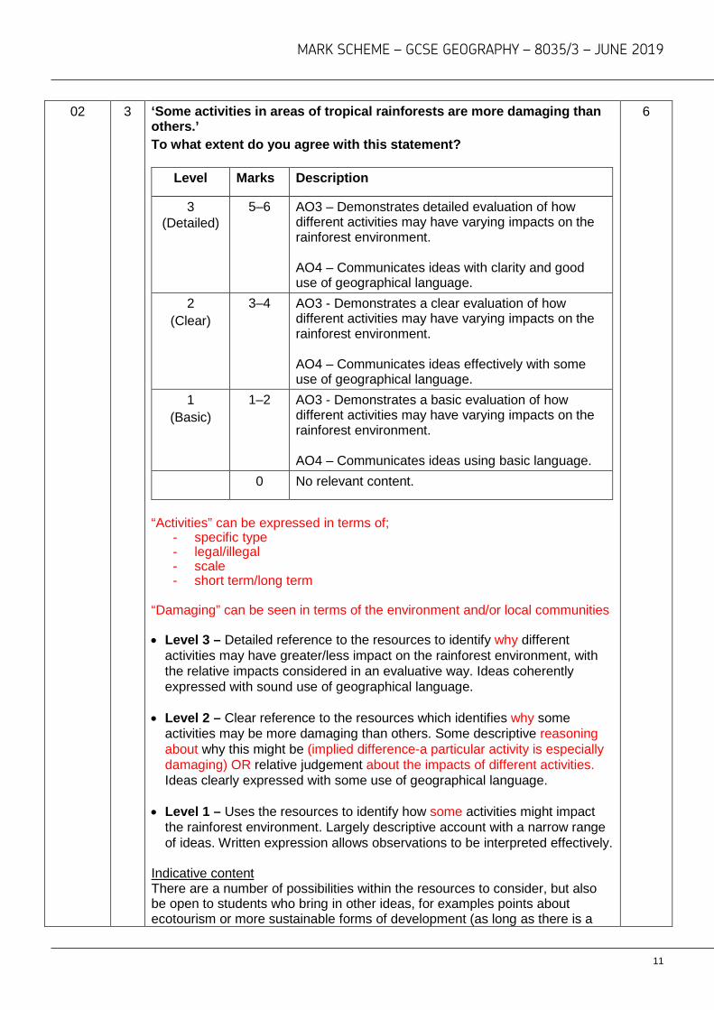
02 3 ‘Some activities in areas of tropical rainforests are more damaging than others.’ To what extent do you agree with this statement?
Level Marks Description
3 (Detailed)
5–6 AO3 – Demonstrates detailed evaluation of how different activities may have varying impacts on the rainforest environment. AO4 – Communicates ideas with clarity and good use of geographical language.
2 (Clear)
3–4 AO3 - Demonstrates a clear evaluation of how different activities may have varying impacts on the rainforest environment. AO4 – Communicates ideas effectively with some use of geographical language.
1 (Basic)
1–2 AO3 - Demonstrates a basic evaluation of how different activities may have varying impacts on the rainforest environment. AO4 – Communicates ideas using basic language.
0 No relevant content.
“Activities” can be expressed in terms of;
- specific type - legal/illegal - scale - short term/long term
“Damaging” can be seen in terms of the environment and/or local communities
• Level 3 – Detailed reference to the resources to identify why different
activities may have greater/less impact on the rainforest environment, with the relative impacts considered in an evaluative way. Ideas coherently expressed with sound use of geographical language.
• Level 2 – Clear reference to the resources which identifies why some
activities may be more damaging than others. Some descriptive reasoning about why this might be (implied difference-a particular activity is especially damaging) OR relative judgement about the impacts of different activities. Ideas clearly expressed with some use of geographical language.
• Level 1 – Uses the resources to identify how some activities might impact
the rainforest environment. Largely descriptive account with a narrow range of ideas. Written expression allows observations to be interpreted effectively.
Indicative content There are a number of possibilities within the resources to consider, but also be open to students who bring in other ideas, for examples points about ecotourism or more sustainable forms of development (as long as there is a
6
11

MARK SCHEME – GCSE GEOGRAPHY – 8035/3 – JUNE 2019
clear comparative judgement which references the resource information as well): • different activities require varying amounts of land and consequently varying
amounts of deforestation • some activities may be more sympathetic to the natural environment • some activities may have a broader effect on different parts of the
ecosystem (mining may not only damage the land but also affect water courses
• activities that use chemical inputs can affect both the land and water systems
• some activities have a larger spread effect (affecting land outside of the initial development footprint).
AO3 = 3, AO4 = 3
03 1 What does the information in the ‘Peru: development fact file’ suggest about levels of development in Peru?
Level Marks Description
2 (Clear)
3–4 AO2 – Shows a clear understanding of the idea of socio-economic development
AO3 – Demonstrates clear application of knowledge to offer interpretive observations about what the data suggests about the level of development of Peru.
1 (Basic)
1–2 AO2 – Basic understanding of what is meant by socio-economic development.
AO3 – Demonstrates limited application of knowledge to offer simplistic interpretive observations about the level of development of Peru.
0 No relevant content.
No credit for simply copying the data with no attempt to explain/link to the idea of development.
• Level 2 – Clear reference to the resources which clearly identifies the socio-economic conditions within Peru. Some clear relative understanding of the data (high/low in relation to levels of development) and how rural/urban differences suggest a lack of development.
• Level 1 – Uses data from the resource to identify the level of development of
Peru, with limited relative understanding (they don’t have many doctors/not many people have internet access). Quoting urban/rural differences with limited explanation.
The question requires candidates to make appropriate links between content from different parts of the course. Indicative content
4
12

MARK SCHEME – GCSE GEOGRAPHY – 8035/3 – JUNE 2019
• General socio-economic data suggests a low level of development. • Extreme poverty in many areas. • Lack of social facilities in many areas. • Distinct differences between rural-urban areas. • Suggestion of almost a “dual” socio-economic structure between rural-urban
areas.
AO2 = 2 marks, AO3 = 2 marks
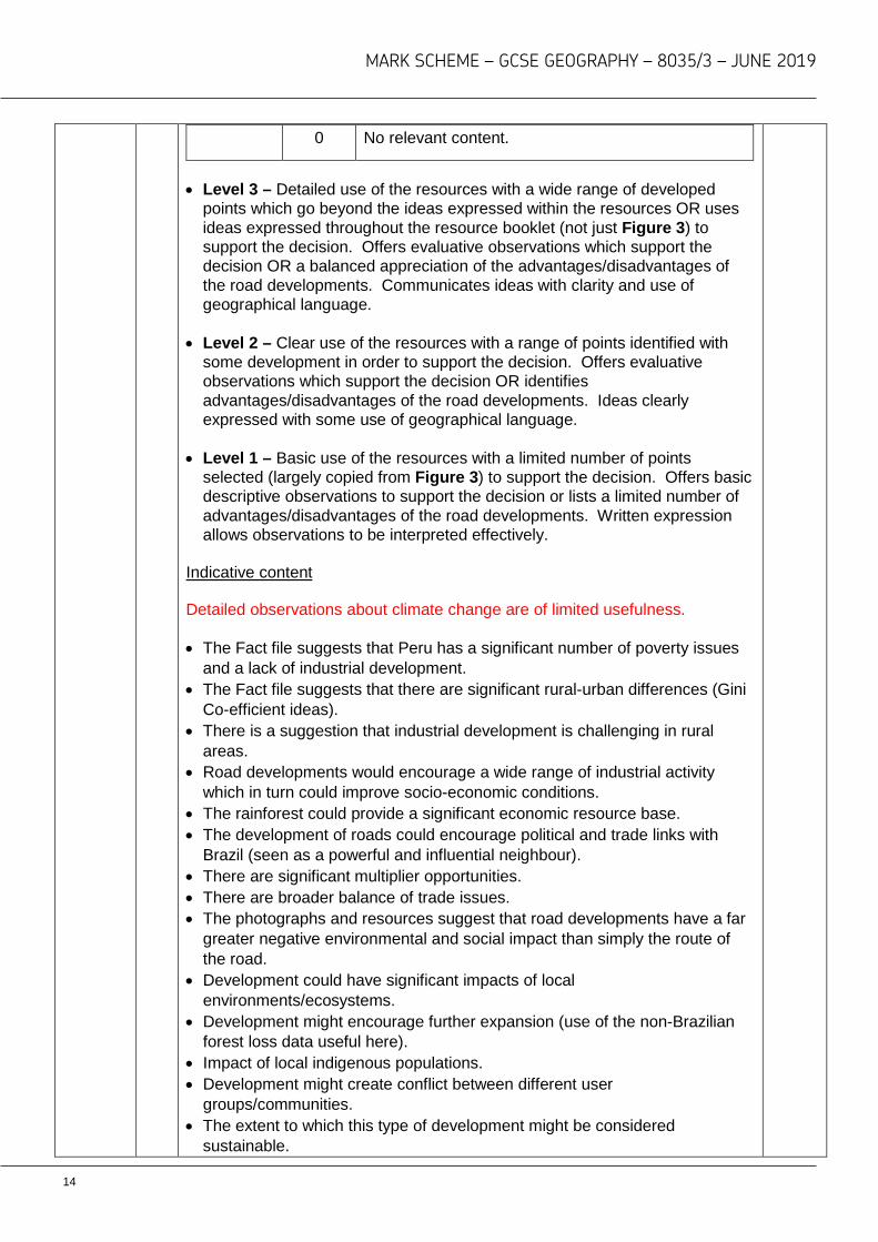
03 2 ‘The Peruvian government has decided to allow the development of new roads in the Amazon.’ Do you think that this was the right decision? Use evidence from the resources booklet and your own understanding to explain your choice.
Level Marks Description
3 (Detailed)
7–9 AO3 – Demonstrates thorough application of knowledge and understanding in evaluating the impacts of road developments in Peru. AO3 – Applies knowledge and understanding to make a decision based on a wide range of evidence, making specific links between different elements of the specification. AO4 – Communicates ideas with clarity and good use of geographical language.
2 (Clear)
4–6 AO3 – Demonstrates reasonable application of knowledge and understanding in evaluating the impacts of road developments in Peru. AO3 – Applies knowledge and understanding to make a decision based on a reasonable range of evidence, making some links between different elements of the specification. AO4 – Communicates ideas effectively with some use of geographical language.
1 (Basic)
1–3 AO3 – Demonstrates basic application of knowledge and understanding in evaluating the impacts of road developments in Peru. AO3 – Applies knowledge and understanding to make a decision which uses a narrow range of evidence, making basic links between different elements of the specification. AO4 – Communicates ideas using basic language.
9 + 3
SPaG
13
MARK SCHEME – GCSE GEOGRAPHY – 8035/3 – JUNE 2019
0 No relevant content.
• Level 3 – Detailed use of the resources with a wide range of developed
points which go beyond the ideas expressed within the resources OR uses ideas expressed throughout the resource booklet (not just Figure 3) to support the decision. Offers evaluative observations which support the decision OR a balanced appreciation of the advantages/disadvantages of the road developments. Communicates ideas with clarity and use of geographical language.
• Level 2 – Clear use of the resources with a range of points identified with some development in order to support the decision. Offers evaluative observations which support the decision OR identifies advantages/disadvantages of the road developments. Ideas clearly expressed with some use of geographical language.
• Level 1 – Basic use of the resources with a limited number of points selected (largely copied from Figure 3) to support the decision. Offers basic descriptive observations to support the decision or lists a limited number of advantages/disadvantages of the road developments. Written expression allows observations to be interpreted effectively.
Indicative content Detailed observations about climate change are of limited usefulness. • The Fact file suggests that Peru has a significant number of poverty issues
and a lack of industrial development. • The Fact file suggests that there are significant rural-urban differences (Gini
Co-efficient ideas). • There is a suggestion that industrial development is challenging in rural
areas. • Road developments would encourage a wide range of industrial activity
which in turn could improve socio-economic conditions. • The rainforest could provide a significant economic resource base. • The development of roads could encourage political and trade links with
Brazil (seen as a powerful and influential neighbour). • There are significant multiplier opportunities. • There are broader balance of trade issues. • The photographs and resources suggest that road developments have a far
greater negative environmental and social impact than simply the route of the road.
• Development could have significant impacts of local environments/ecosystems.
• Development might encourage further expansion (use of the non-Brazilian forest loss data useful here).
• Impact of local indigenous populations. • Development might create conflict between different user
groups/communities. • The extent to which this type of development might be considered
sustainable.
14

MARK SCHEME – GCSE GEOGRAPHY – 8035/3 – JUNE 2019
• Observations about the merit of other types of development might be appropriate.
AO3 = 6 marks, AO4 = 3 marks Spelling, punctuation and grammar (SPaG) High performance • Learners spell and punctuate with consistent accuracy. • Learners use rules of grammar with effective control of meaning overall. • Learners use a wide range of specialist terms as appropriate.
Intermediate performance • Learners spell and punctuate with considerable accuracy. • Learners use rules of grammar with general control of meaning overall. • Learners use a good range of specialist terms as appropriate.
Threshold performance • Learners spell and punctuate with reasonable accuracy. • Learners use rules of grammar with some control of meaning and any errors
do not significantly hinder meaning overall. • Learners use a limited range of specialist terms as appropriate.
No marks awarded • The learner writes nothing. • The learner’s response does not relate to the question. • The learner’s achievement in SPaG does not reach the threshold
performance level, for example errors in spelling, punctuation and grammar severely hinder meaning.
3
2
1
0
15

MARK SCHEME – GCSE GEOGRAPHY – 8035/3 – JUNE 2019
Section B: Fieldwork
Qu Pt Marking guidance Total marks
04 1 Complete table (Figure 4) by filling in the data for Area B and Area D.
2 x 1 mark Area Original area of
countryside (hectares)
Area lost to housing
developments (hectares)
Remaining countryside (hectares)
% loss of countryside
A 240 24 216 10
B 320 160 160 50
C 260 39 221 15
D 420 84 336 20
AO4 = 2 marks
2
04 2 Complete the pie chart below to show the information for Figure 5.
Two sectors completed accurately and shaded in correct order for 1 mark. Nearest to beach – 8% Other reasons – 6%
AO4 = 1 mark
1
04 3 Name the type of sampling method used in Figure 6.
D: Systematic sampling where points are chosen at regular intervals. 1 mark for correct answer.
1
16
MARK SCHEME – GCSE GEOGRAPHY – 8035/3 – JUNE 2019
No mark if more than one answer selected. AO4 = 1 mark
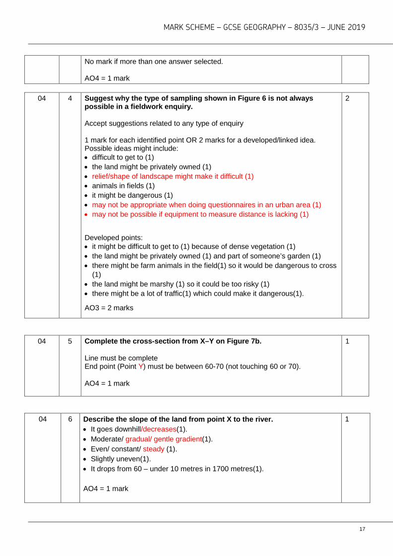
04 4 Suggest why the type of sampling shown in Figure 6 is not always
possible in a fieldwork enquiry. Accept suggestions related to any type of enquiry 1 mark for each identified point OR 2 marks for a developed/linked idea. Possible ideas might include: • difficult to get to (1) • the land might be privately owned (1) • relief/shape of landscape might make it difficult (1) • animals in fields (1) • it might be dangerous (1) • may not be appropriate when doing questionnaires in an urban area (1) • may not be possible if equipment to measure distance is lacking (1)
Developed points: • it might be difficult to get to (1) because of dense vegetation (1) • the land might be privately owned (1) and part of someone’s garden (1) • there might be farm animals in the field(1) so it would be dangerous to cross
(1) • the land might be marshy (1) so it could be too risky (1) • there might be a lot of traffic(1) which could make it dangerous(1).
AO3 = 2 marks
2
04 5 Complete the cross-section from X–Y on Figure 7b. Line must be complete End point (Point Y) must be between 60-70 (not touching 60 or 70). AO4 = 1 mark
1
04 6 Describe the slope of the land from point X to the river. • It goes downhill/decreases(1). • Moderate/ gradual/ gentle gradient(1). • Even/ constant/ steady (1). • Slightly uneven(1). • It drops from 60 – under 10 metres in 1700 metres(1). AO4 = 1 mark
1
17
MARK SCHEME – GCSE GEOGRAPHY – 8035/3 – JUNE 2019
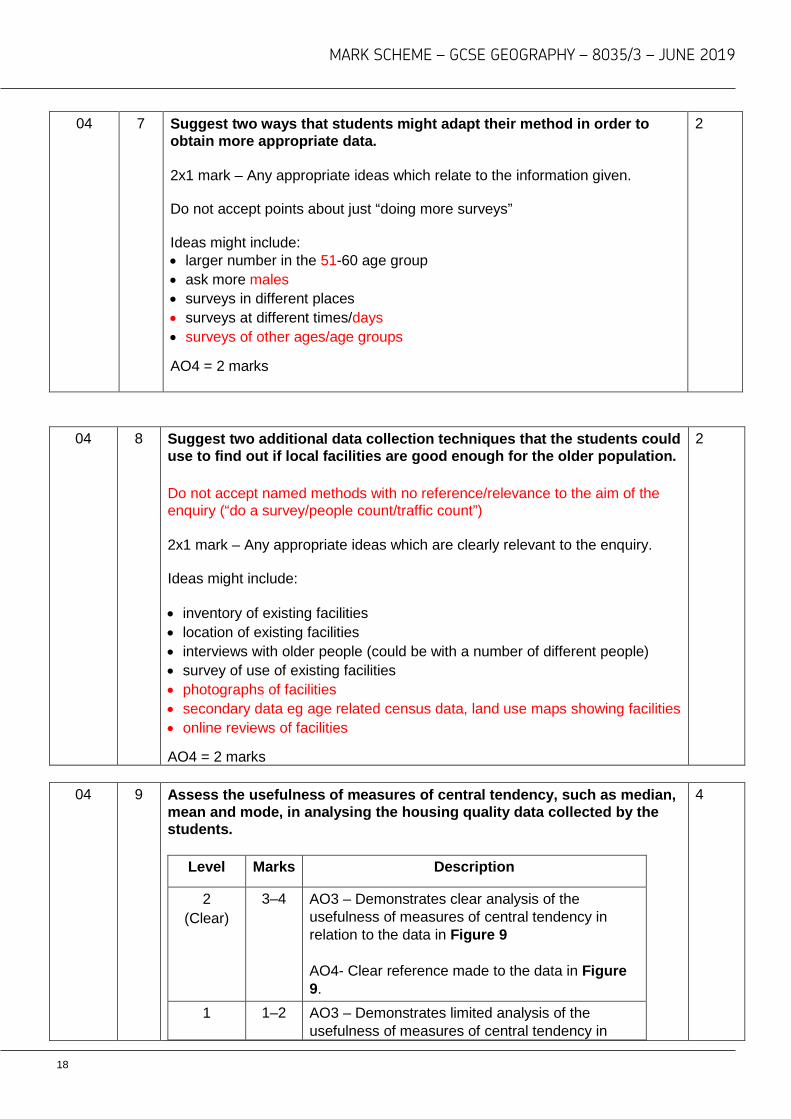
04 7 Suggest two ways that students might adapt their method in order to obtain more appropriate data. 2x1 mark – Any appropriate ideas which relate to the information given. Do not accept points about just “doing more surveys” Ideas might include: • larger number in the 51-60 age group • ask more males • surveys in different places • surveys at different times/days • surveys of other ages/age groups
AO4 = 2 marks
2
04 8 Suggest two additional data collection techniques that the students could use to find out if local facilities are good enough for the older population. Do not accept named methods with no reference/relevance to the aim of the enquiry (“do a survey/people count/traffic count”) 2x1 mark – Any appropriate ideas which are clearly relevant to the enquiry. Ideas might include: • inventory of existing facilities • location of existing facilities • interviews with older people (could be with a number of different people) • survey of use of existing facilities • photographs of facilities • secondary data eg age related census data, land use maps showing facilities • online reviews of facilities
AO4 = 2 marks
2
04 9 Assess the usefulness of measures of central tendency, such as median,
mean and mode, in analysing the housing quality data collected by the students.
Level Marks Description
2 (Clear)
3–4 AO3 – Demonstrates clear analysis of the usefulness of measures of central tendency in relation to the data in Figure 9 AO4- Clear reference made to the data in Figure 9.
1 1–2 AO3 – Demonstrates limited analysis of the usefulness of measures of central tendency in
4
18

MARK SCHEME – GCSE GEOGRAPHY – 8035/3 – JUNE 2019
(Basic) relation to the data in Figure 9 AO4 - Some reference made to the data in Figure 9.
0 No relevant content.
• Level 2 – An appreciation that the measures may be useful in giving a
general impression OR that they have limitations OR some reference to the individual measures in relation to the data OR that other measures might be more useful.
• Level 1 – Basic understanding that the measures only give a general
understanding. Limited link to the data in Figure 9.
MAX 1 mark for evidence of correct calculation. Candidates can achieve low Level 2 by offering a clear assessment related to one type of measure of central tendency. 2 or more techniques required for 4 marks.
Indicative content • The mode cannot be calculated/trimodal/ 1,6,10. • The mean is 5.41 / approximately 5.5. • The median is 5.5. • There are limitations to each measure of central tendency. • Measures of central tendency have limited use in the context of the data
since it is really about identifying differences and patterns. • Other measures might be more useful eg interquartile range, range
AO3 = 2 marks, AO4 = 2 marks
05 1 Suggest why one set of data you collected in your physical fieldwork enquiry may not have been accurate. There is an expectation that the response should relate to the physical fieldwork enquiry. One data set only which should be clearly identified. Accept any reasonable idea which focuses on accuracy/reliability. Max 1 mark for generic point(s), which might include: • not enough data • poor sampling • errors with equipment • data recording affected by the weather • because of the risks associated with data collection. Developed points (2 marks) Allow basic or generic point which then links to specific physical enquiry.
2
19

MARK SCHEME – GCSE GEOGRAPHY – 8035/3 – JUNE 2019
• Only collecting data on one day (1) meant that we couldn’t see changes in
vegetation over time (d) (1) • We were unable to find all the painted pebbles (1) so the measurement of
longshore drift was inaccurate (d) (1) • The clinometer was sticking(1) so getting accurate slope measurements was
difficult (d)(1) • The river was in flood(1) so it was not possible to accurately measure the
width of the channel.(d)(1)
Max 1 mark if reference to human geography investigation. AO3 = 2 marks
20

MARK SCHEME – GCSE GEOGRAPHY – 8035/3 – JUNE 2019
05 2 Identify one potential risk in your physical geography fieldwork and
explain how the risk was reduced. There is an expectation that the response should relate to the physical fieldwork enquiry. 1 mark for the clear identification of a risk which is linked to the physical geography enquiry (be aware that some risks may well be generic/vague, for example weather based risks/becoming isolated). Risks may include:
• The land was steep/uneven ground • The temperature was very high/very cold • The risk of becoming isolated • The river was running fast • The tide came in quickly • The cliff face was unstable
Risks may be expressed as outcomes eg slipping, falling, drowning Up to 2 marks for identifying way(s) of reducing the identified risk:
• There was a risk of becoming isolated or lost (1) so we all carried mobile phones (1)
• The river was running fast (1) so we carried out our measurements in a safer location (1)
• The temperature was too hot (1) so we applied suncream (1) and we wore hats (1).
• There was a risk of slipping (1) so we wore appropriate footwear (1) and we carried walking poles (1)
• The cliff face was unstable (1) so all students were issued with hard hats (1) and were told not to go nearer than 5 metres of the cliff (1).
Alternatively 2 marks for a developed idea:
• The temperature was too hot (1) so we applied suncream (1), which meant that we were unlikely to be affected by sunburn (d) (1)
• There was a risk of slipping (1) so we wore appropriate footwear (1) so we didn’t fall over and injure ourselves (d) (1)
• There was a risk of becoming isolated or lost (1) so we all carried mobile phones (1). This meant that we could contact the teacher if there was an emergency (d) (1)
• The river was running fast (1) so we carried out our measurements in a different location (1), which meant that we didn’t fall over in the river(d)(1)
• The cliff face was unstable (1) so all students were issued with hard hats (1) to avoid injury from being hit by falling rock (d) (1)
No credit for repetition of initial risk.
Max 1 mark if reference to human geography investigation. AO3 = 3 marks
3
21

MARK SCHEME – GCSE GEOGRAPHY – 8035/3 – JUNE 2019
22
MARK SCHEME – GCSE GEOGRAPHY – 8035/3 – JUNE 2019
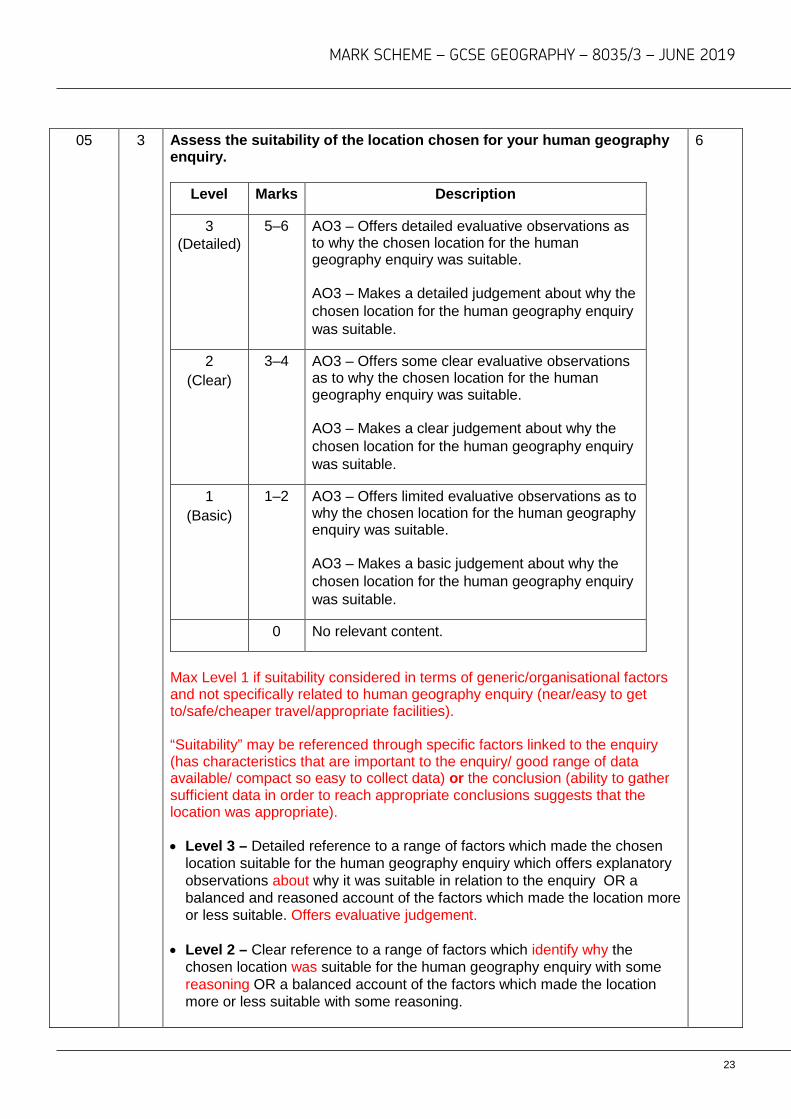
05 3 Assess the suitability of the location chosen for your human geography
enquiry.
Level Marks Description
3 (Detailed)
5–6 AO3 – Offers detailed evaluative observations as to why the chosen location for the human geography enquiry was suitable. AO3 – Makes a detailed judgement about why the chosen location for the human geography enquiry was suitable.
2 (Clear)
3–4 AO3 – Offers some clear evaluative observations as to why the chosen location for the human geography enquiry was suitable. AO3 – Makes a clear judgement about why the chosen location for the human geography enquiry was suitable.
1 (Basic)
1–2 AO3 – Offers limited evaluative observations as to why the chosen location for the human geography enquiry was suitable. AO3 – Makes a basic judgement about why the chosen location for the human geography enquiry was suitable.
0 No relevant content.
Max Level 1 if suitability considered in terms of generic/organisational factors and not specifically related to human geography enquiry (near/easy to get to/safe/cheaper travel/appropriate facilities). “Suitability” may be referenced through specific factors linked to the enquiry (has characteristics that are important to the enquiry/ good range of data available/ compact so easy to collect data) or the conclusion (ability to gather sufficient data in order to reach appropriate conclusions suggests that the location was appropriate). • Level 3 – Detailed reference to a range of factors which made the chosen
location suitable for the human geography enquiry which offers explanatory observations about why it was suitable in relation to the enquiry OR a balanced and reasoned account of the factors which made the location more or less suitable. Offers evaluative judgement.
• Level 2 – Clear reference to a range of factors which identify why the
chosen location was suitable for the human geography enquiry with some reasoning OR a balanced account of the factors which made the location more or less suitable with some reasoning.
6
23

MARK SCHEME – GCSE GEOGRAPHY – 8035/3 – JUNE 2019
• Level 1 – Basic identification of a small number of factors which made the location suitable for the human geography enquiry OR offers an advantage and/or a disadvantage in terms of the suitability.
Max Level 1 for reference to suitability of physical geography location.
Indicative content The command is “assess the suitability” so there is an expectation of a judgement which is supported by evidence. So the focus of the question is an evaluation of the degree to which the location of the human geography enquiry was suitable. • Students may adopt an approach which assumes suitability and identifies
evidence in order to support this view. • Students may adopt a more evaluative approach by considering both
advantages and disadvantages of the location. • There should be an expectation that students will consider the question in
relation to the enquiry process, for example: o the scale of the enquiry o links to geography o availability of data o reliability and accuracy of data o capacity to collect sufficient information to draw reasoned conclusions.
AO3 = 6 marks
05 4 To what extent did the data collected for one of your enquiries allow you to reach valid conclusions?
Level Marks Description
3 (Detailed)
7–9 AO3 – Demonstrates a detailed evaluation of the data in relation to the needs of the enquiry. AO3 – Makes an informed judgement about the extent to which the data provided sufficient evidence to make valid conclusions. AO3- Makes an informed judgement about the extent to which the enquiry allowed valid conclusions to be reached.
2 (Clear)
4–6 AO3 – Some clear evaluative observations about the data in relation to the needs of the enquiry. AO3 – Makes a clear judgement about the extent to which the data provided sufficient evidence to make valid conclusions. AO3- Makes a clear judgement about the extent to which the enquiry allowed valid conclusions to be reached.
9 + 3 SPaG
24

MARK SCHEME – GCSE GEOGRAPHY – 8035/3 – JUNE 2019
1 (Basic)
1–3 AO3 – Some basic evaluative observations about the data in relation to the needs of the enquiry. AO3 – Makes a basic judgement about the extent to which the data provided sufficient evidence to make valid conclusions. AO3- Makes a basic judgement about the extent to which the enquiry allowed valid conclusions to be reached.
0 No relevant content.
• Level 3 – Detailed reference to the usefulness of the data in relation to the
aims of the enquiry with some appreciation of whether it provided sufficient evidence to draw effective conclusions. If it is felt that the data did provide sufficient evidence/did not provide sufficient evidence there needs to be evaluative observations supporting this view.
• Level 2 – Clear reference to the usefulness of the data in relation to the aims of the enquiry with some appreciation of whether it provided evidence in relation to the aims of the enquiry to draw effective conclusions. If it is felt that the data did provide sufficient evidence/did not provide sufficient evidence there needs to be some reference expressing this view.
• Level 1 – Outlines methods which are linked to the enquiry and suggests reasons for the data collection with implied appreciation of its value.
Indicative content The command is “to what extent” so the focus of the question is an evaluation of the degree to which the data collected allowed the student to reach valid conclusions. So there is an expectation of a judgement which is supported by evidence. • ‘Valid conclusions’ can be interpreted in different ways. • The response should be seen in relation to the title of the enquiry and the
relative challenge of obtaining data. • Students might consider the amount of data or the spread of data (across
time). • Students might consider the question in terms of reliability/accuracy. • The question can be considered in relation to both primary and secondary
evidence. • It is expected that students will consider “sufficient evidence” in relation to
the aims of the enquiry and the extent to which the data allowed conclusions to be valid.
• Credit reference to additional data as implied evaluation.
AO3 = 9 marks
25

MARK SCHEME – GCSE GEOGRAPHY – 8035/3 – JUNE 2019
Spelling, punctuation and grammar (SPaG) High performance • Learners spell and punctuate with consistent accuracy. • Learners use rules of grammar with effective control of meaning overall. • Learners use a wide range of specialist terms as appropriate.
Intermediate performance • Learners spell and punctuate with considerable accuracy. • Learners use rules of grammar with general control of meaning overall. • Learners use a good range of specialist terms as appropriate.
Threshold performance • Learners spell and punctuate with reasonable accuracy. • Learners use rules of grammar with some control of meaning and any errors
do not significantly hinder meaning overall. • Learners use a limited range of specialist terms as appropriate.
No marks awarded • The learner writes nothing. • The learner’s response does not relate to the question.
The learner’s achievement in SPaG does not reach the threshold performance level, for example errors in spelling, punctuation and grammar severely hinder meaning.
3
2
1
0
26