geography 3202 grading standards june 2003€¦ · geography 3202 grading standards june 2003 ......
TRANSCRIPT

World Geog. 3202 Grading Standards June 2003Page 1 of 59
Geography 3202Grading Standards June 2003
For a copy of the Final Exam, go to the http://www.gov.nl.ca/edu/k12/pub/sample.htm
1. Pre-Marking Appraisal
• The number of case studies required a substantial amount of reading. There wasan indication that the last case studies were poorly done.
• Selected Response questions 7 & 20 should be omitted. Question 7 graphic wasconfusing (inverted) and question 20 was worded incorrectly. Question 20 shouldhave read “west to east” as opposed to “east to west”.
• As well Question 76 was omitted as the concept of “analytic process” was notnecessarily in the outcomes. For the same reason question 25 was also omitted.
2 Post-Marking Report
Marking Standard and Consistency
• 50 papers were used to determine the consistency. These papers went throughduring the first day. Approximately 5 papers went through each of the followingdays. This process confirmed the reliability of the marking.
Commentary on Response
- Students still lack knowledge of the “key verbs” and the quality of the answerthey imply.
- Students are lifting answers from case studies and not analyzing the informationin the cases.
- Many students are not providing a thesis statement- Students are not using enough “Geographical Terms” to explain the concepts
tested.- Students are not using data from graphs and charts to develop their answers.- All Part 11 answers should be in essay style and not jot note form.- Students are not integrating information in Case Study (charts, graphs) with their
prior knowledge to develop answer.

World Geog. 3202 Grading Standards June 2003 Page 2 of 59
Constructive Response/Common Errors
73. Commentary on Response
Overall this question was well answered.
Common Errors:
- students identified the water pollution as the physical change, not the lowerlevels.
- also, some students identified the physical change but instead of providingevidence they gave the cause.
Answer Key:
Looking For - change (description of ) in the Aral Sea. (1 mark)- 1 piece of evidence to show the change (1mark)
Physical Change - surface area of the Aral Sea decreased during the time period
mentioned.
Evidence - Map from New Scientist (1960-84)- Communities near the edge of the sea in the past are now 60km
inland.- (paragraph 4, pg.17) water level in the Aral Sea itself was lowered
15m- (observations of a journalist pg. 19)
- paragraph 2 - remains of sunken boats now visible- paragraph 4 - disappearance of summer camp along the
shoreline- paragraph 9 - observations of the retired fisherman

World Geog. 3202 Grading Standards June 2003Page 3 of 59
Sample Responses

World Geog. 3202 Grading Standards June 2003 Page 4 of 59
74. Commentary of Response
This question was generally poorly answered with students failing to develop aneconomic argument: because it was presented as a fishermen’s argument, many failedto see the importance of issues that are not directly related to the fishery. A number ofstudents omitted #74 though completing #73 and #75.
Common Errors:
- Students focused on non-economic issues- Students often spoke passionately as a fisherman and in doing so often
overlooked issues not directly related to the fishery- Students did not refer to charts, graphs, etc., but concentrated on essay section of
case study- Students did not ‘develop’ an argument. They did not discuss the negative effects
of the project and follow with the positive impact of reversing the project- Students did not refer to multiplier effect or spin-off industries
Answer Key:
- The question requires students to synthesize information and create a briefeconomic argument for reversing the Aral Sea Project. Students should point outthat the original purpose of the Project was not met in the long run and that othereconomic activities would have a positive effect on employment.- failure of the Aral Sea Project (1) in increasing cotton production (1)- positive effect of restoring the fishery (1)- potential for expanding the raising of cattle (1)- potential development of aquaculture (1) or tourism opportunities (1)- the effect of multiplier effect (1)

World Geog. 3202 Grading Standards June 2003Page 5 of 59
- The original purpose of the Aral Sea Project, to increase cotton production, haslargely failed. Cotton production did increase from 1956 to 1980, but afterwardscotton production decreased (2). Reversal of the project would restore the fishery,in which fish catches declined after 1968, and create employment in harvestingand processing fish (1). The decrease in windborne sand and drop in use ofpesticides would help improve the nutritional quality of grasses and restore thecattle industry (1). Other opportunities would also emerge in the tourism industry(1) and possibly aquaculture (1). As the fishery and cattle industries grow, jobs inthe service sector would open up due to the multipler effect (1).

World Geog. 3202 Grading Standards June 2003 Page 6 of 59
Sample Responses

World Geog. 3202 Grading Standards June 2003Page 7 of 59

World Geog. 3202 Grading Standards June 2003 Page 8 of 59
75. Commentary on Response
Overall question was well done. All students began question with a thesis statementand followed with examples from the case study. Many students also related theirthesis statement to quality of life indicators studied in the course.
Common Errors:
- not supporting thesis statement with specific examples from the case study- not relating statement to quality of life indicators from the course- students would focus on one factor such as the fishery and not use any supporting
examples
Answer Key:
The question required students to assess the social impact of the project on people in the area. References to quality of life indicators from the case study or from thecourse material should be made:- reference to quality of life indicator from the following list:
- environmental quality- health- community life- economy- cultural life- psychological well being- demographics (migration, IMR, DR, etc)
- 1 mark was awarded for each example used or 2 marks for an example that wasexpanded upon for a total of 5 marks from the explanation.

World Geog. 3202 Grading Standards June 2003Page 9 of 59
Sample Responses

World Geog. 3202 Grading Standards June 2003 Page 10 of 59

World Geog. 3202 Grading Standards June 2003Page 11 of 59

World Geog. 3202 Grading Standards June 2003 Page 12 of 59
76. Commentary on Response
The responses to this question were poor. It appeared students did not understand theanalytic manufacturing process.
Common Errors:
Student who scored poorly either left the answer blank or lifted sections of the casestudy. The definition of analytic was neither implied nor explicit.
Answer Key:
The question requires a listing of 2 examples to reflect the analytic process involved in the manufacturing of raw sugar.- Students should/could include:
- a definition of the analytic process -either explicitly stated or implied(1mark)
- examples to show the analytic process is involved (1 mark) or if the studentslisted 2 of the products made from the sugar cane (1 mark for each productlisted).
Sample Responses

World Geog. 3202 Grading Standards June 2003Page 13 of 59
77. Commentary on Response
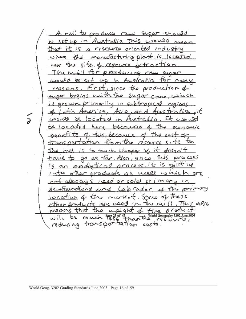
Generally, this question has not been written well. Lack of geographical terms andaddition of climate (below) are 2 possible reasons for poor question quality.
Common Errors:- Students referred to climate as one of the main reasons Australia is the preferred
choice for the sugar cane mill.- The absence of proper geographical terms in this answer (weight-loss, value
gained).
Answer Key:
- The manufacturing of raw sugar is an example of a resource-oriented industry.Such industries use low-value and bulky raw materials for their imputs. It is noteconomical to ship such materials over great distances, since it would be toocostly. (2)
- As the case study dictates, only 14% of sugar cane contains SUCROSE - thenecessary ingredient for sugar crystals. Locating the mill in Australia would placeit near the resource and eliminate the cost of shipping cane fibre; water and otheringredients over the great distances. Since raw sugar and molasses have a highervalue then sugar cane, transportation would involve a lower cost per unit of weight(3)
- Also, Australia would be a better choice because the climate for growing the sugarcane is more favourable, therefore it would lessen the likelihood of spoilage beforeprocessing. (1)

World Geog. 3202 Grading Standards June 2003 Page 14 of 59
Sample Responses

World Geog. 3202 Grading Standards June 2003Page 15 of 59
World Geog. 3202 Grading Standards June 2003 Page 16 of 59

World Geog. 3202 Grading Standards June 2003Page 17 of 59
78. Commentary on Response
- Many students did not attempt this question.- Some students may have assumed that question #78 was related to Case Study #2- Students who attempted this question produced poor responses.
Common Errors:
- colonialism was confused with multinational corporations, industrial, evolution,etc.
- students did not go beyond a definition - many did not know a definition- students attempted to extract answers from Case Study #2 “Producing Raw Sugar”

World Geog. 3202 Grading Standards June 2003 Page 18 of 59
- students attempted to apply inappropriate geographical terms such as:(a) agglomerating tendency(b) green revolution(c) lard reform(d) migration(e) appropriate technology(f) transportation nodes(g) native world view(h) the term colonial power and colonies were often confused
Sample Responses

World Geog. 3202 Grading Standards June 2003Page 19 of 59
79. Commentary on Response
Most students did well with this question.
Common Errors:
None
Answer Key:
- “. . . development of agriculture improvements that would close the gap betweenfood production and consumption.” (2%)
- develop a high yield varieties of seeds (1)- “irrigation systems and the use of fertilizers and pesticides” (1)- use of mechanization, new technologies (1)- to increase food production (1)

World Geog. 3202 Grading Standards June 2003 Page 20 of 59
Sample Responses
80. Commentary on Response
Generally well done by students.
Common Errors:
- Most students did not attempt to define appropriate technology even though it wasan integral part of the answer.

World Geog. 3202 Grading Standards June 2003Page 21 of 59
Answer Key:
- Statement of what appropriate technology is (1%)- One piece of evidence to show that appropriate technology was not used in the
Green Revolution (2%)- One piece of evidence to show that Cuba did adhere to the principles of
appropriate technology (2%)- Appropriate technology involves the use of equipment and processes that are
suited to the culture and economy of a given region. This approach helps to ensurethat the new strategy can be locally managed and maintained. (1%)
- The Green Revolution involved the introduction of large-scale strategies (highyield varieties of seeds, pesticides, fertilizers, irrigation systems, equipment) fromoutside that proved to be too expensive for poor farmers to sustain. Theinfrastructure to get the product to market did not exist. (2%)
- In contrast, the Cuban government introduced small-scale changes that wereadapted to local conditions. Land was distributed in small plots to farmers, vacanturban lots were devoted to organic farming; farmer-markets were established toshore up prices; and farming techniques addressed environmental concerns. TheCuban government saw that agricultural change had to be based on localknowledge that came from within the country, rather than from outside thecountry.(2%)
- In conclusion, the Green Revolution failed because appropriate technology was notused and the Cuban experiment was successful because appropriate technologywas used. (1%)

World Geog. 3202 Grading Standards June 2003 Page 22 of 59
Sample Responses

World Geog. 3202 Grading Standards June 2003Page 23 of 59

World Geog. 3202 Grading Standards June 2003 Page 24 of 59

World Geog. 3202 Grading Standards June 2003Page 25 of 59
World Geog. 3202 Grading Standards June 2003 Page 26 of 59
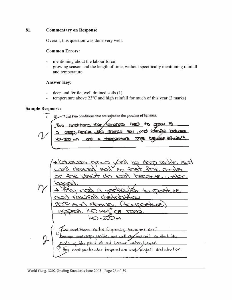
81. Commentary on Response
Overall, this question was done very well.
Common Errors:
- mentioning about the labour force- growing season and the length of time, without specifically mentioning rainfall
and temperature
Answer Key:
- deep and fertile; well drained soils (1)- temperature above 23oC and high rainfall for much of this year (2 marks)
Sample Responses

World Geog. 3202 Grading Standards June 2003Page 27 of 59
82. Commentary on Response
This question came from the optional unit on Land Resources and involved student’s taking evidence from the Case Study to support a position they took with regard tocategorizing a banana plantation as commercial or subsistence The majority ofstudents completing this question did a better than average job.
Common Errors:
Students associated manual labour with subsistence agriculture.
Answer Key:
- commercial farming (1)- different between commercial/subsistence (2)- apply characteristics of community agriculture to the case study
1) size2) labour3) markets
4) technologyOr any two of quality (3)
- Banana Plantation is commercial- Commercial Farm - large tract of land, large amount of capital, produces a crop for
scale.- Subsistence Farm - small in size, labour intensive, produces a crop for family
consumption.
Characteristics
- size - Banana plantation is large-scale (7000ha)- labour/tech - requires large amounts of capital - 10 000 workers needed to plant,
maintain, harvest, research and prepare for export. Also, equipment such as cablesystems, conveyor belts, packing stations, refrigeration equipment are required.
- markets - crop is geared toward export so particular attention is given to washing,grading and temp-control to ensure a quality product.

World Geog. 3202 Grading Standards June 2003 Page 28 of 59
Sample Responses

World Geog. 3202 Grading Standards June 2003Page 29 of 59
83. Commentary on Response
Approximately 25% of the students did not answer this question. The majority ofstudents who answered this question did a good job on the answer. However, some didnot use the proper terminology

World Geog. 3202 Grading Standards June 2003 Page 30 of 59
Common Errors:
- Many students did not briefly describe but simply listed.
Answer Key:
- Oil can find its way into the ocean environment through accidental spills and theintentional dumping of used oil into drainage systems and from ship bilges. (1)
- During drilling operations, drilling mud is used and is often released into theocean. This material is laced with chemicals and contaminated oil. (1)
- Large quantities of oil are released into the ocean when sea-going tankers runaground, (i.e. Exxon Valdez). (1)
- Ice bergs can be a serious problem. Near and on the Grand Banks icebergs travelthrough an area called “Ice Berg Ally” which is a dangerous zone for drilling. OneIceberg can puncture an oil rig and possibly sink one depending on its size. Packice would be on the same level. (1)
- Huge storms, with strong winds and severe seas can destroy an oil platform in ashort time. This could be both a serious human disaster and a possible oil spill (i.e.Ocean Ranger. (1)
- Financial risk. There are a lot of problems. Hit and miss operations. Also, therecan be a lot of expensives incurred with problems on site. (1)

World Geog. 3202 Grading Standards June 2003Page 31 of 59
Sample Responses

World Geog. 3202 Grading Standards June 2003 Page 32 of 59
84. Commentary on Response
Most students received part marks on this question. They described the changes inaquaculture but did not compare it to changes in oceanic fish catch and beefproduction.
Common Errors:
Students generally were not making a comparison. Some students described % of change but miscalculated the percentages.

World Geog. 3202 Grading Standards June 2003Page 33 of 59
Answer Key:
The students should provide comparative information from the table of statistics for aspecific period to show that aquaculture production is gaining on the oceanic fisheryand beef production.
- statistics on the change in aquaculture (1 mark)- comparative statistics for the 3 categories. (2 marks)- qualitative descriptions of why aquaculture was increasing (collapse of the
fisheries worldwide; mad cow disease causing people to search for other proteinsources ) (1 mark)
Sample Responses

World Geog. 3202 Grading Standards June 2003 Page 34 of 59
85. Commentary on Response
From the responses it is obvious that students lacked knowledge of aquaculture. Thecase study referred to cold water temperatures as a cause for the decline in stocks -students deducted from this that you could control water temperatures in aquaculture.
Common Errors:
- responses were more toward the reasons for the collapse of the fishery
Answer Key:
- The offshore fishery is experiencing two problems that can be addressed by theaquacultural industry. (1)
- Fish catches are declining and it is difficult to get a steady supply of fishthroughout the year. As a result, the livelihoods of many fishers are at risk. (2)
- In order for aquaculture to reduce the need to harvest a declining marine resourceand give it time to regenerate - aquacultural production has more than tripled since1985. The many inlets and coves along the province’s coast provide many naturalsites where aquaculture can be expanded. The fish raised in pens grow faster thanthey would in the wild. (1)
- As well, the fish can be harvested when there is a seasonal scarcity and marketprices are high, particular during the winter months. (1)
- Finally a year-long supply of fish helps to reduce periods of unemployment causedby overfishing and seasonal changes in fish catches. (1)

World Geog. 3202 Grading Standards June 2003Page 35 of 59
Sample Responses

World Geog. 3202 Grading Standards June 2003 Page 36 of 59

World Geog. 3202 Grading Standards June 2003Page 37 of 59

World Geog. 3202 Grading Standards June 2003 Page 38 of 59
86. Commentary on Response
Most students understood the point relating to location.
Common Errors:
- Many students missed the point referring to containerization- Many students referred to the fact that Singapore is linked to Malaysia and the
Asian Mainland by land cause waves as their second piece of evidence.
Answer Key:
- The student should cite two pieces of information to illustrate that Singapore is atransportation node. One relates to location and the other to container transshipment. (2 marks)
- Singapore is located on the southern tip of the Malaysia Peninsula where major sealays between India and China meet. (1 mark)
- Singapore port is a hub where many conatiners destined for other south east Asianports pass through. In 200, over 17 million TEUS passed through the port. (1 mark)
Sample Responses

World Geog. 3202 Grading Standards June 2003Page 39 of 59
87. Commentary on Response
Few did this section/unit Case study (Unit 7). Students spoke mostly about thelocation of Singapore in relation to both Asia and Europe. Others commented on atleast one of the high points - infrastructure, economics, and market demand.
Common Errors:
Discussed “location” only in relation to Singapore being a trans shipment hub.
Answer Key:
- statement does not fully explain - one of several factors (1)- Location - southern tip of Malaysia- on major sea routes between India and China (1)- Explain any 2 of the following (2% each)
Infrastructure - put needed facilities into place- ranked higher than USA- facilities also for linkage within the country

World Geog. 3202 Grading Standards June 2003 Page 40 of 59
Economic Planning - invited foreign investors- development in technology, shifting economic
activity, education to trainMarket Demands - larger ships and reduction in time- technological soft/hard ware to increase loading and unloading
efficiency
Sample Responses

World Geog. 3202 Grading Standards June 2003Page 41 of 59

World Geog. 3202 Grading Standards June 2003 Page 42 of 59

World Geog. 3202 Grading Standards June 2003Page 43 of 59
88. Commentary on Response
Response to this question was generally well done. Accepted a variety of terms:- population is shrinking/aging- natural decrease- population decrease- population declining- not self-sustaining
Common Errors:
Many students alluded to the low birth rate and longer life expectancy but did not referto population decrease in some way.
Answer Key:
- The student should state the native of the population crisis, without explaining itscause or effects. (2 marks)
- The European population is shrinking as the number of deaths exceed the numbersof births (2 marks)
- One mark for deaths exceed births

World Geog. 3202 Grading Standards June 2003 Page 44 of 59
Sample Responses

World Geog. 3202 Grading Standards June 2003Page 45 of 59
89. Commentary on Response
Overall, the question was challenging. Most students opened with the statement that itwas valid. Most students recognized that it was a two stem approach to addresspopulation concerns. Many could also see that it was not just a simple approach thatmore immigrants will solve all the concerns. It was also noteworthy to recognize thatstudents could see that by reducing pensions or forcing potential retirees to worklonger would not be a popular political decision.
Common Errors:
- Not enough detail- Listing statistics from case study- Dwelling only on negatives of immigration
Answer Key:
Question 89 - 6 Marks- evidence to support migration critical to addressing the issue (employment
tax burden) (2 points)- evidence to support that other considerations must come into play (i.e.
seniors working longer) (2 points)- need for a two-prong approach (reduction of costs and expansion of the work
force) to solve the problem along with examples from the case study for eachapproach (4)

World Geog. 3202 Grading Standards June 2003 Page 46 of 59
Sample Responses

World Geog. 3202 Grading Standards June 2003Page 47 of 59

World Geog. 3202 Grading Standards June 2003 Page 48 of 59

World Geog. 3202 Grading Standards June 2003Page 49 of 59

World Geog. 3202 Grading Standards June 2003 Page 50 of 59
90. Commentary on Response
This question was not done well.
Common Errors:
- Students did not clearly state the purpose of building new towns as being the overpopulation of Cairo.
- Many times stated the positive effects of the reduced population densities.
Answer Key:
- The students should provide a statement about the purpose for building new townsaround Caira. (2 marks)
- New towns were built around Caira to relieve the problems resulting from highpopulation densities, such as a shortage of housing, lack of public services, trafficcongestion and pollution
Sample Responses

World Geog. 3202 Grading Standards June 2003Page 51 of 59

World Geog. 3202 Grading Standards June 2003 Page 52 of 59
91. Commentary on Response
Most students agreed in favour of the “New Town” idea. They used the reference ofurban problems to state their argument - did not use Case Study for reference points,but personal experience. There were a few students who argued both ways. Very fewresponded as stipulated in answer key.
Common Errors:
Some tried to argue that if managed correctly - with reference to urban problems -it would have worked.
Answer Key:
Failures in Egypt - commuting from Cairo to New Towns, such as 40% workers (3%) commute form Cairo
- public services did not meet demands of New Towns residents- investors from Cairo purchase houses and raised price too
high for regular workers.
Not a setting for North America - services are being met(2%) - have resources to meet the needs and have
resources to improve cities- people commute into the city from outer areas

World Geog. 3202 Grading Standards June 2003Page 53 of 59
Sample Responses

World Geog. 3202 Grading Standards June 2003 Page 54 of 59
WORLD GEOGRAPHY 3202 PART 1 - SECTION A
SELECTED - RESPONSE ITEM ANALYSIS
Item
Responses
Multiple Answers orNo Response A B C D
% % % % %
This section covers Units 1, 2, 3, 6 and 10
1. Correct answer is B 0.2 2.8 73.9 16.5 6.5
2. Correct answer is A 0.2 70.6 4 17.7 7.5
3. Correct answer is A 0.6 59.2 15.7 12.3 12.2
4. Correct answer is A 0.2 65.1 14.3 7.9 12.6
5. Correct answer is B 0 5.3 87.3 6.5 0.9
6. Correct answer is D 0.2 2.8 25.4 14.4 57.2
7. Excluded from exam Excluded from exam
8. Correct answer is A 0.2 49.6 6.4 23.4 20.3
9. Correct answer is D 0.2 28.5 14 7.7 49.6
10. Correct answer is C 0.1 1 1.5 96.4 1
11. Correct answer is A 0.1 93.9 1.3 3.3 1.4
12. Correct answer is B 0.3 23.2 39.1 19.2 18.2
13. Correct answer is A 0.3 59.2 6.8 19.5 14.2
14. Correct answer is A 0.2 54 7.7 24.2 13.9
15. Correct answer is D 0.4 2.7 24 9.9 63
16. Correct answer is B 0.3 12.7 49.5 19 18.4
17. Correct answer is C 0.1 9.8 1.9 82 6.1
18. Correct answer is B 0.2 16.1 55.9 23.2 4.6
19. Correct answer is B 0.1 12.2 81 5.1 1.6
20.Excluded from exam Excluded from exam
21. Correct answer is D 0.1 2.6 9.5 0.8 87
22. Correct answer is A 0.1 85.2 10.5 1 3.2
23. Correct answer is C 0.2 9.6 33.6 50.7 5.9
24. Correct answer is D 0.3 1.7 9.1 28.6 60.2
25.Excluded from exam Excluded from exam
26. Correct answer is C 0.2 4.3 3 74.6 18
27. Correct answer is D 0.4 13.4 22.3 29.7 34.2
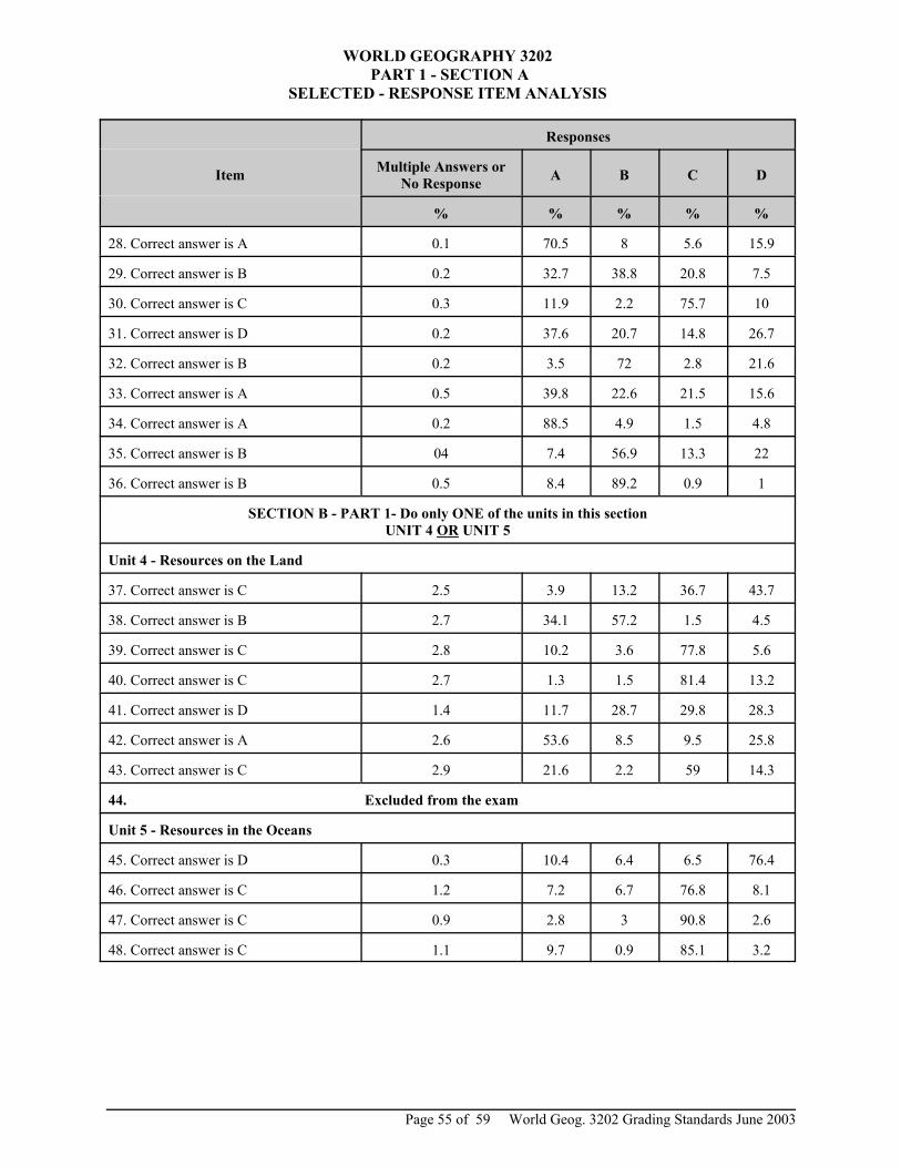
World Geog. 3202 Grading Standards June 2003Page 55 of 59
WORLD GEOGRAPHY 3202 PART 1 - SECTION A
SELECTED - RESPONSE ITEM ANALYSIS
Item
Responses
Multiple Answers orNo Response A B C D
% % % % %
28. Correct answer is A 0.1 70.5 8 5.6 15.9
29. Correct answer is B 0.2 32.7 38.8 20.8 7.5
30. Correct answer is C 0.3 11.9 2.2 75.7 10
31. Correct answer is D 0.2 37.6 20.7 14.8 26.7
32. Correct answer is B 0.2 3.5 72 2.8 21.6
33. Correct answer is A 0.5 39.8 22.6 21.5 15.6
34. Correct answer is A 0.2 88.5 4.9 1.5 4.8
35. Correct answer is B 04 7.4 56.9 13.3 22
36. Correct answer is B 0.5 8.4 89.2 0.9 1
SECTION B - PART 1- Do only ONE of the units in this sectionUNIT 4 OR UNIT 5
Unit 4 - Resources on the Land
37. Correct answer is C 2.5 3.9 13.2 36.7 43.7
38. Correct answer is B 2.7 34.1 57.2 1.5 4.5
39. Correct answer is C 2.8 10.2 3.6 77.8 5.6
40. Correct answer is C 2.7 1.3 1.5 81.4 13.2
41. Correct answer is D 1.4 11.7 28.7 29.8 28.3
42. Correct answer is A 2.6 53.6 8.5 9.5 25.8
43. Correct answer is C 2.9 21.6 2.2 59 14.3
44. Excluded from the exam
Unit 5 - Resources in the Oceans
45. Correct answer is D 0.3 10.4 6.4 6.5 76.4
46. Correct answer is C 1.2 7.2 6.7 76.8 8.1
47. Correct answer is C 0.9 2.8 3 90.8 2.6
48. Correct answer is C 1.1 9.7 0.9 85.1 3.2

World Geog. 3202 Grading Standards June 2003 Page 56 of 59
WORLD GEOGRAPHY 3202 PART 1 - SECTION A
SELECTED RESPONSE ITEM ANALYSIS
Item
Responses
Multiple Answers orNo Response A B C D
% % % % %
SECTION C - PART 1- Do only ONE of the units in this sectionUNIT 7 OR UNIT 8 OR UNIT 9
Unit 7- Linkage in Human Interaction
49. Correct answer is A 2.4 79.3 8.9 3.6 5.9
50. Correct answer is B 5.3 8.3 33.7 48.5 4.1
51. Correct answer is C 11.8 5.9 20.7 58 3.6
52. Correct answer is C 11.8 3.6 13 50.3 21.3
53. Correct answer is C 11.2 6.5 26 49.1 7.1
54. Correct answer is C 11.8 21.3 20.1 36.7 10.1
55. Correct answer is D 11.2 4.1 7.7 7.1 69.8
56. Correct answer is D 11.2 4.7 8.9 12.4 62.7
Unit 8 - Population
57. Correct answer is C 0.3 0.5 18.1 78.7 2.3
58. Correct answer is D 0.5 7.4 5.7 20.2 66.2
59. Correct answer is B 0.3 3.2 93.4 2.5 0.6
60. Correct answer is A 0.4 57.6 18 6.2 17.8
61. Correct answer is C 0.2 36.5 2.7 58.9 1.8
62. Correct answer is A 2.5 56.3 23.6 10.6 6.9
63. Correct answer is D 2.8 15.2 40.1 6.4 35.5
64. Correct answer is A 3.1 71.9 10.2 10.3 4.6
Unit 9 - Settlement and Urbanization
65. Correct answer is D 1.2 3.2 17.2 10.5 67.9
66. Correct answer is B or C 3.2 20.1 28.1. 43.5 5.1
67. Correct answer is D 3.7 18.7 4.8 15.8 57
68. Correct answer is C 3.6 9.9 8.7 35.2 42.7
69. Correct answer is A 3.9 40.1 30.6 15.1 10.2
70. Correct answer is D 3.7 6.3 10.5 5.4 74
71. Correct answer is B 6.1 23.1 52.4 8.5 9.9
72. Correct answer is D 6.6 4.8 0.9 2 85.7

World Geog. 3202 Grading Standards June 2003Page 57 of 59
WORLD GEOGRAPHY 3202 PART 11 - SECTION B
SHORT AND CONSTRUCTED - RESPONSE ANSWERSITEM ANALYSIS
Item StudentsCompleting Item Value Average Average %
Per Item
PART II - SECTION A - Do ALL questions in the section
73 3322 2 1.42 71.15
74 3322 4 1.85 46.32
75 3322 6 3.73 62.10
76 Excluded from the exam
77 3322 6 2.67 44.57
78 3322 4 0.58 14.41
79 3322 2 1.41 70.50
80 3322 6 3.27 54.50
PART 11 - SECTION B - Do only ONE of the units in this sectionUNIT 4 OR UNIT 5
Unit 4 - Resources on the Land
81 1196 2 1.84 92.22
82 1196 6 2.97 49.43
Unit 5 - Resource on the Oceans
83 2041 4 1.70 42.54
84 2041 2 1.04 52.03
85 2041 6 2.53 42.14
PART 11- SECTION C - Do only ONE of the units in this sectionUNIT 7, UNIT 8, OR UNIT 9
Unit 7 - Linkages in Human Interaction
86 128 2 0.96 48.05
87 128 6 2.09 34.90
Unit 8 - Population
88 2395 2 1.69 84.32
89 2395 6 2.95 49.22
Unit 9 - Settlement and Urbanization
90 668 2 1.36 68.11
91 668 6 2.48 41.32

World Geog. 3202 Grading Standards June 2003 Page 58 of 59
World Geography 3202 School Marks
0
100
200
300
400
500
600
700
800
900
0 - 9 10 -19 20 -29 30 -39 40 - 49 50 -59 60 -69 70 -79 80 -89 90 -100
Num
ber o
f Stu
dent
s
World Geography 3202 Exam Marks
0
100
200
300
400
500
600
700
800
900
0 - 9 10 -19 20 -29 30 -39 40 - 49 50 -59 60 -69 70 -79 80 -89 90 -100
Num
ber o
f Stu
dent
s
World Geog. 3202 Grading Standards June 2003Page 59 of 59
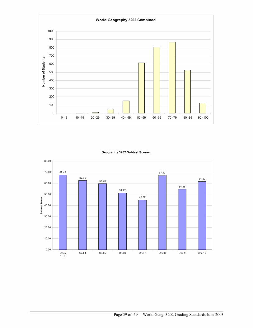
World Geography 3202 Combined
0
100
200
300
400
500
600
700
800
900
1000
0 - 9 10 -19 20 -29 30 -39 40 - 49 50 -59 60 -69 70 -79 80 -89 90 -100
Num
ber o
f Stu
dent
s
Geography 3202 Subtest Scores
67.48
62.3559.48
51.27
45.02
67.13
54.56
61.49
0.00
10.00
20.00
30.00
40.00
50.00
60.00
70.00
80.00
Units1 - 3
Unit 4 Unit 5 Unit 6 Unit 7 Unit 8 Unit 9 Unit 10
Subt
est S
core
s