geographical controls of mountain meteorological elements latitude continentality altitude...
Post on 20-Dec-2015
235 views
TRANSCRIPT

Geographical Controls of Mountain Meteorological Elements
Latitude
Continentality
Altitude
Topography

Role of Topography

Topography- Temperature on Mountain Summits

Topography- Temperature on Mountain Summits
During the eighteenth century there was still considerable controversy as to the cause of the general temperature decrease with height.
De Sussure, was the first physical scientist to approach a realistic explanation of the cause of cold in mountains. (Barry, 1978).
Read: Barry 1978

Topography- Temperature on Mountain Summits
From several studies, the primary control of free air-summit temperature difference seems to be the atmospheric temperature structure.
Peppler (1931) found that, in the Alps, mountain temperatures are closest to those in the free air when the lapse rate is nearly adiabatic between 1-3 km.
With isothermal or inversion conditions, temperatures in both summer and winter are considerably loweer on mountain summits.

Topography- Temperature on Mountain Summits
Pepin et al. (1999) showed for stations in the Pennines, lapse rates are determined by atmospheric temperature and moisture level, cloudiness/solar radiation, and wind speed.
Changes in lapse rate can result from changes in the frequency of cyclonic/anticyclonic circulation regimes.
Rolland (2003) analyzed 640 stations in the Austrian-Italian Alps and showed that many earlier studies are biased by the use short records and limited number of stations. Rolland, C. 2003. Spatial and seasonal variations of air temperature lapse rates in alpine regions. Journal of Climate 16:1032–1046.

Topography- Temperature on Mountain Summits
Rolland (2003) used stations that ranged in altitude from below 100 m to over 2000 m, and identified valley and slope sites.
Lapse rates are calculated using simple linear regression of temperature with altitude in four station groups.
Fig. 2.14

Topography- Temperature on Mountain Summits
The influence of nocturnal inversions at night and of near-adiabatic conditions by day, in addition to effects of foehn winds and katabatic drainage winds, led von Ficker (1926) to declare that “true” lapse rates cannot be determined in mountain regions.
A unique approach of measurement was performed by Brocks (1940) in which he determined density differences in layers over the Austrian Alps.
Brocks found that the diurnal amplitude of lapse rate decreases with altitude more rapidly in the free air over the plains than over the mountains.
Brock also found that the mountain atmosphere extends above the mean ridge height. Similar to the model by Ekhart (1948).

Topography- Temperature on Mountain Summits
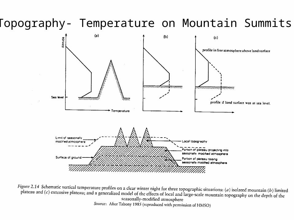
Important to distinguish between the effects of local topography which cause diurnal changes in lapse rate and large-scale topographic effects that modify the atmospheric structure.
Tabony (1985) outlines three idealized topographic situations:
Fig 2.15
1. Isolated mountain2. Plateau of limited extent3. Extensive plateau
Topography- Temperature on Mountain Summits

Topography- Temperature on Mountain Summits
1913 von Hahn noted that temperatures observed at summit stations, on average, are lower than those in the free air at the same level.
Later studies (McCutchan 1983; Richner an Phillips 1984) show that mountain peaks are warmer in the afternoon and colder in the early morning.

Topography- Temperature in Mountain Environments
Dobrowski, Abatzoglou, Greenberg, and Schladow (2009) suggest that air temperature in mountain environments (in their study area—Lake Tahoe basin) is driven primarily by regional temperature patterns.
They mention, but neglect the role of stability and decoupling due to cold air pooling in enclosed terrain.
They use “Free Air” estimates from NARR which provides assimilated temperature data at 3 hr and 32 km resolution.
Please read and write a discussion on this paper for Monday. Think about techniques used and are these valid when comparing the ideas of Ekhart (1938).

The effect of mountains on wind flow over them has aroused early interest in the topic since peoples have occupied mountainous areas.
Georgii (1922) argued that wind speeds on summits generally increase above mountain summits up to a level of 30% of the mountain altitude. He termed this effect as the ‘influence height’.
This was argued by A. Wagner that it is not a good generalization.
Topography- Wind Speeds on Mountain Summits

Wind observations on mountain summits and in the free air was carried out by Wahl (1966). From data for European stations, in general, speeds on summits average approximately half of the corresponding free-air values.
Topography- Wind Speeds on Mountain Summits

Topography- Wind Speeds on Mountain Summits

There are two basic factors which affect wind speeds on mountain summits (Barry 1992).
These operate in opposition to each other.
1.The vertical compression of airflow over a mountain causes acceleration of the air.
2.Frictional effects cause retardation.
Frictional drag in the loer layers of the atmosphere is caused partly by ‘skin friction’ (shear stress), due to small-scale roughness elements (< 10 m).
Topography- Wind Speeds on Mountain Summits

Additional frictional effects are caused by ‘form drag’ which is due to topographic features 0.1-1 km in size that set up dynamic pressure perturbations.
In mountain areas, form drag contributes the largest proportion to the total friction.
Over simple 2-D terrain, drag increases in proportion to the slope2, up to the point where flow separation takes place (Taylor et al. 1989).
Topography- Wind Speeds on Mountain Summits

Balloon measurements in the central Alps indicate that drag influences extend up to about 1 km above the local mean ridge altitude of 3 km.
Special soundings made during ALPEX (Alpine Experiment) show that the airflow over the central Swiss Alps is decelerated up to about 4 km (600 mb). Ohmura (1990) suggests that momentum transfer between the atmosphere and the mountains takes place from about 4 km down to 500 m below ridge tops.
Topography- Wind Speeds on Mountain Summits

Many of the wind profiles indicated a wind maximum at 1.5 km above the ridges with speeds greater than over the adjacent lowlands.
Schell (1936) attempted to explain contrasting observations with tethered balloons on three summits in the Caucasus at 1300 m. He concluded that in the case of an isolated peak, or and exposed ridge, the compressional effect outweighs frictional retardation.
Resulting in stronger winds up to about 50-100 m over the summit than overlying free air.
Topography- Wind Speeds on Mountain Summits