geoe 218.3 engineering geology department of civil ... · geoe 218 – assignment 2 solutions 1. (6...
TRANSCRIPT

GeoE 218 – Assignment 2
Solutions 1. (6 marks) Consider the following geologic and stratigraphic features.
a) List the 3 oldest geologic features and the 5 youngest and briefly justify
your choice. 3 Oldest: E,K,A OR E,F,K 5 Youngest: G,H,I,J,L
b) If you were searching for a location for a nuclear fuel waste repository, are there any units or formations here that you would either definitely wish to investigate or that you would remove from consideration at the outset? Provide reasons (briefly)? F and maybe deep in G. Because they are likely stable and impermeable. Definitely not in L or near any faults or active volcanoes.
Department of Civil & Geological Engineering GEOE 218.3 Engineering Geology
ASSIGNMENT #2
Due Date: Friday 24 September, 2010 before 12:30 pm Hand in to: There will be a box outside 1C18 for this assignment
The information you’ll need for this lab is, for the most part, in the course notes and in the extra reading material posted on the course website but you will need to dig around for some more background information, and you will need to use some engineering judgement to answer some of the questions. 1. Consider the following geologic and stratigraphic features.
a) List the 3 oldest geologic features and the 5 youngest and briefly justify your choice.
b) If you were searching for a location for a nuclear fuel waste repository, are there any units or formations here that you would either definitely wish to investigate or that you would remove from consideration at the outset? Provide reasons (briefly)?
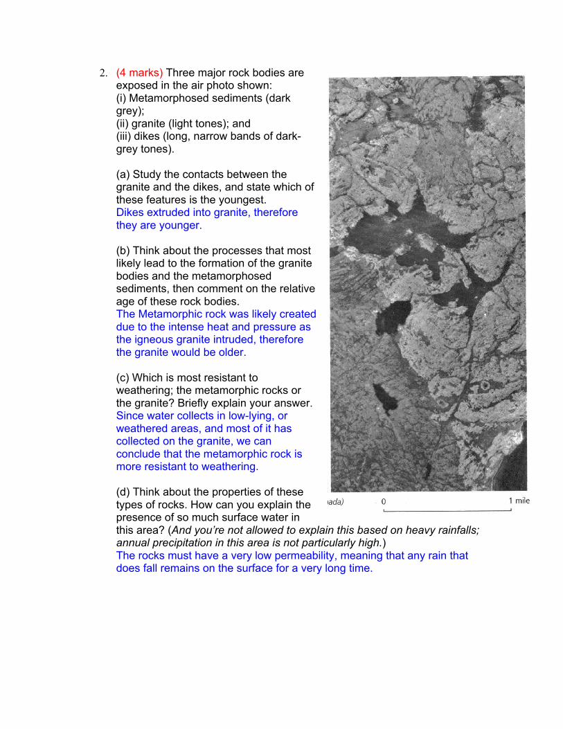
2. (4 marks) Three major rock bodies are exposed in the air photo shown: (i) Metamorphosed sediments (dark grey); (ii) granite (light tones); and (iii) dikes (long, narrow bands of dark-grey tones). (a) Study the contacts between the granite and the dikes, and state which of these features is the youngest. Dikes extruded into granite, therefore they are younger. (b) Think about the processes that most likely lead to the formation of the granite bodies and the metamorphosed sediments, then comment on the relative age of these rock bodies. The Metamorphic rock was likely created due to the intense heat and pressure as the igneous granite intruded, therefore the granite would be older. (c) Which is most resistant to weathering; the metamorphic rocks or the granite? Briefly explain your answer. Since water collects in low-lying, or weathered areas, and most of it has collected on the granite, we can conclude that the metamorphic rock is more resistant to weathering. (d) Think about the properties of these types of rocks. How can you explain the presence of so much surface water in this area? (And you’re not allowed to explain this based on heavy rainfalls; annual precipitation in this area is not particularly high.) The rocks must have a very low permeability, meaning that any rain that does fall remains on the surface for a very long time.
2. Three major rock bodies are exposed in the air photo shown:
(i) Metamorphosed sediments (dark grey); (ii) granite (light tones); and (iii) dikes (long, narrow bands of dark-grey tones). (a) Study the contacts between the granite and the dikes, and state which of these features is the youngest. (b) Think about the processes that most likely lead to the formation of the granite bodies and the metamorphosed sediments, then comment on the relative age of these rock bodies. (c) Which is most resistant to weathering; the metamorphic rocks or the granite? Briefly explain your answer. (d) Think about the properties of these types of rocks. How can you explain the presence of so much surface water in this area? (And you’re not allowed to explain this based on heavy rainfalls; annual precipitation in this area is not particularly high.)

3. (3 marks) The Caribbean Islands are a great place to visit when the prairie winter kicks in. They are also very interesting geologically. The Lesser Antilles forms an arc of islands separating the Atlantic Ocean from the Caribbean Sea. Geologists call this a Volcanic Island Arc, i.e. a curved chain of volcanoes, approx. 530 miles long, between Puerto Rico and Venezuela, where the Caribbean tectonic plate meets the Atlantic plate. Mont Pelée in Martinique is an active volcano which has erupted in the 1790’s, 1850’s and in 1902 (when the City of St. Pierre was devastated) and again in the 1930’s. Other regional volcanoes include Soufrière in Saint-Vincent, La Soufrière in Guadeloupe and the Soufrière Hills in Montserrat.
a) List the processes involved in the formation of the islands. What
processes are still ongoing today? Volcanism and sea bed rise due to the collision of the tectonic plates. The warm shallow waters also provide perfect habitat for the formation of coral reef islands. All processes may still be ongoing.
3. The Caribbean Islands are a great place to visit when the prairie winter kicks in. They are also very interesting geologically. The Lesser Antilles forms an arc of islands separating the Atlantic Ocean from the Caribbean Sea. Geologists call this a Volcanic Island Arc, i.e. a curved chain of volcanoes, approx. 530 miles long, between Puerto Rico and Venezuela, where the Caribbean tectonic plate meets the Atlantic plate. Mont Pelée in Martinique is an active volcano which has erupted in the 1790’s, 1850’s and in 1902 (when the City of St. Pierre was devastated) and again in the 1930’s. Other regional volcanoes include Soufrière in Saint-Vincent, La Soufrière in Guadeloupe and the Soufrière Hills in Montserrat.
a) List the processes involved in the formation of the islands. What processes are still ongoing today?
b) Starting from the deep water depositional environment on either side of the tectonic plate boundary, sketch a large-scale east-west cross-section and label the important features. Think hard about the depositional environments in various depths of water. c) Some of the smaller islands are not volcanic. How are these other islands formed and what rock type are they composed of? Sketch the depositional environment of islands such as Marie-Galante (just south of Guadeloupe) or Antigua. Why do such islands exist?
b) Starting from the deep water depositional environment on either side of the tectonic plate boundary, sketch a large-scale east-west cross-section and label the important features. Think hard about the depositional environments in various depths of water. See sketch on last page
c) Some of the smaller islands are not volcanic. How are these other islands formed and what rock type are they composed of? Sketch the depositional environment of islands such as Marie- Galante (just south of Guadeloupe) or Antigua. Why do such islands exist? These islands are formed by coral reefs in the shallow waters. They are composed of limestone. The water is shallow because the colliding tectonis plates have raised the sea bed in the area. See sketch on last page.
4. (6 marks) Guadeloupe comprises 2 main islands as shown. The two islands, Grande-Terre and Basse- Terre are separated by a narrow channel. Basse-Terre is a volcanic massif; note the inactive (but still smouldering) volcano “la Souffrière with a height almost 1500 mASL. The prevailing winds (and most of the hurricanes) come from the west , i.e. Grande-Terre is in the lee of Basse- Terre. Given that, what do you expect the easterly island of Grande-Terre is composed of? Limestone What differences would result between the two islands in terms of topography, climate, vegetation, agriculture etc.
Basse-Terre Grande-Terre Topograpy Mountainous Flatter Climate Wet, Windy, Storms Drier, less wind and storms Vegetation Rain Forests Grassy plains Agriculture Less agriculture More agriculture
An Agro friend of yours (?!) is an avid rock collector and amateur prospector who knows nothing about geology. He returns from his vacation with a bag of rocks. He shows you his souvenirs and invites you to invest money in a prospecting venture. You see a dark shiny dense rock with what looks like some bornite in it, another sample of black brittle foliated schist with tiny specs of what looks like native gold. And the third sample looks suspiciously like quartz-rich granite. Where do you suspect each of the samples came from? Bornite and Granite are both igneous rocks, Schist is metamorphic, therefore, all three probably came from the volcanic island of Basse-Terre.

Do you invest? If you did invest, where in Gualdeloupe would you look for each (and why)? You probably should not invest because granite is very common and therefore not valuable, and the “gold” is likely pyrite (fool’s gold). Bornite is a valuable copper ore, but if it was present in any significant quantities it would likely already be exploited. There is simply not enough evidence to justify investing in a large-scale mining operation.
There is another smaller island, Marie-Galante – located about 30 km to the south of Grande- Terre. This island is made up of two distinct sections – each a plateau with a major valley separating them and cutting across the island. Describe (using small sketches as appropriate) the geologic processes that created this island and its current topography. The island was formed from limestone created by a coral reef. The valley is likely due to a fault since it is known that this area is very tectonically active. See sketch on last page.
5. Using the attached bedrock geology map for Saskatchewan, draw a North-South geological cross- section along the east side of the province near the Manitoba border as shown.

See sketch on last page.
5 Using the attached bedrock geology map for Saskatchewan, draw a North-South geological cross-section along the east side of the province near the Manitoba border as shown.
