geodinamica acta - université de montpellier in geodinamica acta 20/5 (2007) 301-326 abstract the...
TRANSCRIPT
1
Latest-Cretaceous/Paleocene karsts with marine infillings from Languedoc (South of France); paleogeographic, hydrogeologic
and geodynamic implications
Pierre-Jean COMBES a∗, Bernard PEYBERNÈS a,b Marie-José FONDECAVE-WALLEZ c,
Michel SÉRANNE a, Jean-Luc LESAGE d, Hubert CAMUS e
a- Géosciences Montpellier, Université Montpellier 2, CNRS, Place Eugène Bataillon, 34095 Montpellier, France. b- 17 rue de Gargas, 31500 Toulouse, France.
c- UMR-CNRS 5563 (LMTG), Université Paul-Sabatier, 14 avenue Edouard-Belin, 31400, Toulouse, France. d- 64, Rue Pitot, 30000 Nîmes, France.
e- Cenote, 1 Chemin de Valdegour, 30900 Nîmes, France.
Publised in Geodinamica Acta 20/5 (2007) 301-326 Abstract The Latest Cretaceous/Paleocene paleokarsts from Bas-Languedoc (South of France) are characterized by : 1) exokarstic paleosurfaces (sink holes, pinnacles, canyons) which are mostly superimposed onto the Late Jurassic limestones and partly filled up with breccias and sandy clays containing Paleocene planktonic foraminifera; 2) endokarstic cavities filled up by sandy pelites and laminated mudstones with similar micropaleontological assemblage. All these cavities constitute three cut-and-filled paleokarstic systems. A general model of formation for this polyphase system is proposed. These paleosurfaces are generated by a Latest Cretaceous tectonic phase and Paleocene movements associated with eustatic rises inducing rapid floodings. During Upper Danian-Lower Selandian times three successive base levels drops, whose cumulated duration could be as long as 3 Ma, have induced several hundred metres of incisions within the exposed Jurassic carbonate series. A paleogeographic reconstruction shows three main marine gulfs which extend towards NE the EW Pyrenean thrust belt (« Pyrenean Paleocene Trough », PPT) located on the axis of the future Pyrenees. The similarity of the facies and micropaleontological content in the two domains suggests connexions between the marine Paleocene deposits of Bas-Languedoc and the PPT. It could thus explain the succession of the same tectono-eustatic events. We propose, as an hypothesis, that the rapid sea-level changes, as recorded by the imbricated karstic paleomorphologies, could be induced by the closing and the opening of a strait in the Eastern part of the PPT acting as a sill. This would be controlled by tectonic movements along the active orogenic axis of the Pyrenean Range and eustatic variations of the Paleocene World Ocean. The karstic systems developed during these low-stand episodes may have been later reactivated after the Early Selandian and more specifically during the Messinian desiccation event. This late evolution may have generated deep flooded karsts, now situated below the present sea level. Such karsts, partly inherited from Paleocene, could be important aquifers of economic interest. Key words: Paleokarst, breccia, Latest Cretaceous/Paleocene, tectonics, eustacy, hydrogeology 1. Introduction
The Bas-Languedoc in Southern France is located between the Palaeozoic Cévennes hills and Mediterranean Sea (Gulf of Lion) (Fig 1). This region is characterized by large paleokarsts
superimposed onto the carbonate series of Middle to Late Jurassic age. These karsts, mostly observed in quarries or recent road works, have provided marine Danian-Selandian planktonic microfauna contained within their internal sediments. Such microfauna from Latest

2
Cretaceous/Paleocene karst have been several times described in previous publications [1, 2, 3]. These similar foraminiferal assemblages allow to correlate the Bas-Languedoc paleokarsts, studied in this paper, with those of the Pyrenees [4, 5, 6, 7] and the Grands-Causses [2].
The study of the outcrops and the systematic analysis of the micropaleontologic content and microfacies of the internal sediments (Plate), allowed us to date their infilling and also to reconstruct a polyphase morphology. The later was determined by cut-and-filled paleosurfaces (sink holes, pinnacles, canyons) and their associated endokarstic systems. All these cavities have been flooded several times during Paleocene and were part of a complex network of sea channels and gulfs, where fossiliferous sediments (sandy clays, hemipelagites and breccias) were deposited. The present contribution will show that these marine extensions were probably connected southwards to the marine domain corresponding to the Eastern part of the « Pyrenean Paleocene Trough » (PPT) [7]. This connection is evidenced by correlating the succession of Paleocene events in the paleokarsts of Bas-Languedoc and of Eastern Pyrenees. Later incisions during Miocene and erosion by the coastal rivers (Hérault, Gardon) during Pliocene and Quaternary (up to present time) have partly reworked the Latest Cretaceous/Paleocene paleogeography and its karstic networks.
2. Paleokarst structures and micropaleontologic data from their successive marine fillings 2.1. Geological setting (Fig 1 and 2) The most significant field data have been obtained especially from the area corresponding to the St Martin-de-Londres 1/50.000 geological sheet [8] between the Grands Causses to the NW and the Viols-le-Fort/Pic St Loup anticline to the SE. In this region outcrops a thick (600 m) series of Tithonian reef limestones which appear strongly karstified at present time [9]. These limestones contain numerous exokarstic morphologies and endokarstic cavities dated of the Paleocene (this note) which indicate that the Jurassic formation was already karstified during this period. The intense karstification of the Late Jurassic reef facies limestone was probably enhanced by fracturing which is particularly well developed between St Martin-de-Londres and St Bauzille-de-Putois. On the contrary, dissolution is not important (if any) within the « Neocomian » (Early Cretaceous) marls and marly limestones of the Causse de Pompignan (Fig 2), increasing the morphological contrast with massive Tithonian limestones. For example, the Lamalou stream is embanked only some tens metres within the Berriasian marls whereas it is incised 200 to 300 m within the Late Jurassic limestones. We will see that such contrasting dissolution rates between marls and limestones has controlled the geomorphology and the paleogeography of this region since the Latest Cretaceous /Paleocene times.
2.2 . The karstic systems P/R
Many observations have been done 30 km NW of Montpellier between St Martin-de-Londres and St Bauzille-de-Putois, along the newly rectified road D 986. The road cuts show a complex paleokarstic system previously discovered by Philip et al. as early as 1978 [8], but lack of datation stopped further studies, until now. The paleokarst system is characterized by breccias and exokarstic surfaces associated with endokarstic cavities filled up by internal sediments, particularly spectacular between the crossing with road D1 and St Bauzille-de-Putois (Fig 3). The successive karstic paleomorphologies (called P) and their fillings (called R) are chronologically described (from the oldest to the youngest) and integrated within palinspastic transects (Fig 4). 2.2.1. Paleosurface P1/Filling R1
North of the road D 107E (site 1, Fig 3; IGN topographic map at 1/25.000, n° 2742 ET, x=713,55, y=3176,1) the strongly recrystallized white Tithonian reef limestones is corroded downwards over 1 to 2 m thick. It contains 1 to 10cm-wide dissolution cavities, more or less anastomosed, filled-up with a red clayey-carbonate internal sediment in which Microcodium « rosettes » have been observed. Such cavities could belong to the exokarst of this P1 paleosurface, whose weathering cracks (corresponding to the epikarst sensu Mangin 1975 [10]) are filled up by the red Microcodium-bearing internal sediment R1. The endokarst related to P1 could correspond to the dissolution-cavities tens of centimetres wide filled-up by concretionary calcite which are prevalent within the Tithonian limestones of this area. Other evidences of the red paleosurface P1 have also been locally observed on the nearby hills. However, its very rare preservation may suggests that P1 could have been almost completely eroded by superimposition of the later karstification events. Although there is no direct dating of this paleosurface, the occurrence of reddish facies and the presence of Microcodium suggest a correlation with the mottled paleosoils of the « Vitrollian » (= local Paleocene continental facies) from the Montpellier area [11, 12]. This filling assigned to « Vitrollian » is cut by SW-NE 80°NW faults which have probably contributed to the dismantlement of the paleosurface P1. These faults could have induced a NE-striking structural high, linking the Bois de Bouis to the Bois de Monnier (Fig 2) and overlooking to the SE the Paleocene to Lutetian lacustrine basin of St Martin-de-Londres. Such paleomorphology suggests that during latest Cretaceous and early Paleocene the Grands Causses (Fig 1 and 2) extended southeastwards to St Martin-de-Londres.
2.2.2. Paleosurface P2/Filling R2

3
In site 1 (Fig 3) P1/R1 are cut downward by a paleosurface P2, displaying ten-centimetres-scale irregularities, and covered with clays and thin-bedded microbrecciated limestones (containing numerous calcitic lithoclasts and very altered fragments of echinodermal plates). This filling corresponds to R2. Laterally, R2 filling has been eroded and the paleosurface P2 overlies Tithonian limestones affected by the earlier NE-trending faults, whose large slickensides are corroded and coated with iron oxi-hydroxides. In numerous localities of this area, particularly on the path to « Les Mates » (x=713,7, y=3176,7), we can observe the remains of P2 paleosurface and R2 fillings made of the microbrecciated limestones. One kilometre to the NW, along the GR 60 (site 2, Fig 3; x=712,6, y=3176,8), in a similar setting, sparitized sandy limestones contain echinodermal debris (Plate, 3) radiolaria (Plate, 13), probable siliceous « spicules » (generally reniform), some benthonic (Plate, 8) and planktonic foraminifera such as Morozovella praeangulata (BLOW), [chronostratigraphic interval P2-P3a] and Globanomalina compressa (PLUMMER) [P1c-P3b]. This assemblage characterizes the subzones and zones P1c-P2-P3 of Late Danian-Early Selandian interval from the Olsson’s et al. standard [13] (Fig 5). This sandy-calcareous facies corresponds to a marine sand, rich in fragments of echinodermal plates and various clasts, deposited onto the karstic paleosurface, then sparitized. Along the old road, 200 metres north of the Cardonille Pass, (site 3, Fig 3), the recristallized Tithonian white limestone is affected by a closely spaced network of anastomosed fractures, filled up by a comparable internal sediment containing Parasubbotina pseudobulloides (PLUMMER) [P1c-P3a ; P3B ?]. The vertical roadcut, located 200 m north of the cross with D1 (site 4, Fig 3), exhibits an intense fracturing and tectonic brecciation of the Tithonian reef limestones (over at least 15 m in thickness) associated with the same internal sediment. This breccia, called Type 1, is characterized by its angular elements that have undergone very little rotations (Fig 6 a), and that are separated by the regular fractures network. This brecciated interval can be assimilated to the epikarstic zone [10, 14] associated to the exokarstic surface P2. It locally displays vertical zones (2 to 5 m diameter) of subrounded elements affected by slickensides resulting from rotations. This is interpreted as the destabilization of type 1 breccias induced by collapse-dissolution processes. This collapse breccia, called Type 2 (Fig 6 a, b), can be still functional and participate to the superimposition of the epikarstic zone within its own substrate.
The endokarst of P2 can be observed at the Cardonille Pass (site 5 a, Fig 3) within the Tithonian limestones, whose stratification is often masked by intense fracturing. On the eastern road-cut, exhibits 0.1 to 1 metre large cavities (coated with macrosparite of white calcite) filled up with ochre thin-laminated microbreccias including corroded clasts of sparite, echinodermal plate fragments and echinoid spines. A thin bed of
sandy limestone, including bryozoan clasts, contains Globanomalina ehrenbergi (BOLLI) [P2-P4]. These cavities clearly cross-cut the highly fractured Jurassic strata but are folded with them. This is particularly well exposed in one example north of the outcrop where the finely bedded internal sediment is folded in an anticline and one limb is affected by layer-parallel thrusting (Fig 3, site 5 b ; Fig 6 c). On the western road-cut, a plurimetric cavity, coated by concretionary calcite (thickness 10cm), with a crust of iron oxi-hydroxides, is filled up with ochre and grey azoic clays, thin-bedded sandy limestones and beige limestones with brown laminae (thickness 10 to 20 cm) which appear, in thin section, as a mosaic of sparite, rich in aggregates of iron oxi-hydroxides, coming from the epigenesis of the test of very abundant radiolaria (Sphoeroidea) (Plate, 1). We also note the presence of Pa. pseudobulloides. These laminated facies are probably due to the diagenetic sparitization of a ferruginous carbonate mud rich in radiolaria. The sandy limestones contain many hematitic clasts (old alterite ?) and fragments of bryozoans (Plate, 2), echinodermal plates, rare radiolaria, a large hyaline foraminifera (similar to Peneroplis) and Globigerinacea such as Gl. compressa, Morozovella gr. angulata, (WHITE) [P2 – lower/mid. P4] and Parasubbotina varianta (SUBBOTINA) [P1c – lower part of P4]. This cavity is also deformed with dips of internal sediments reaching 70° towards NE. The age of the internal sediments of the endokarst of the paleosurface P2 as well as the age of the sediments filling the exokarst are assigned to Late Danian - Early Selandian interval.
The previous data show that occurred the
superposition of two main factors, tectonics and sea-level change, in order to explain the genesis of Danian-Selandian paleokarsts (Fig 4):
- The Vitrollian Microcodium-bearing paleosurface P1 (Fig 4 a, b) is settled within a paleogeography consisting of a topography of Late Jurassic limestones to the NW of a fluvio-lacustrine basin which has existed since « Rognacian » (= continental late Maastrichtian) in the St Martin-de-Londres area [8, 12]. Large scale folding and uplift of the Jurassic limestone and the prominent SW-NE fracturing must have played an important part in the genesis of P1, as well as in the establishment of the exokarst and the endokarst of P2. Incision of the Late Jurassic large-scale anticline was then at least several hundred metres deep, in order to account for the later marine flooding of this paleomorphology while fluvio-lacustrine facies were preserved in the St Martin-de-Londres basin (about 15 m of Rognacian variegated clays and palustrine limestones).
- The following marine transgression (Fig. 4 c) is revealed by the general occurrence of sands, characterized by altered carbonate lithoclasts, echinodermal plates fragments, radiolaria, siliceous « spicules » and detritic quartz. Such marine sands are also present within the infilling R2 of exokarstic structures, the cement of type 1-2

4
breccias and endokarstic cavities. This transgression has probably flooded a karstic morphology including a succession of sink holes and pinnacles which have later been largely erased by the following superimpositions. 2.2.3. Paleosurface P3/Filling R3 The karstic system P3/R3 began with a marine regression and a folding event that induced the deformation of the endokarstic cavities P2/R2 previously described at the Cardonille Pass (Fig 3, site 5; Fig 6 c). A new endokarstic network was formed. This karst network is presently undeformed, as can be observed in several outcrops:
- At site 5 (5 a, Fig 3), a horizontal cavity (4 m x 2 m), cutting down the fractured Tithonian reef limestone, is coated by drusic calcite more or less corroded and covered with ochre sandy clays and carbonate sandstones containing some echinodermal plates debris and numerous fragments of bryozoans;
- At site 6 (Fig 3 ; Fig 6 d), large plurimetric to decametric cavities are excavated within the type 1 breccias or fractured Tithonian limestones; the walls of the cavities are smooth and frequently encrusted with iron-manganese oxi-hydroxides. The circa 10 m-thick filling consists of laminated ochre clays, more or less sandy, containing radiolaria and siliceous spicules, laminated sand (with ferrugineous clasts) and grey clays. Within the northern cavity filling Mo. Praeangulata, Zeauvigerina waiparensis (JENKINS) [Maastrichtian-Eocene] and Subbotina trivialis (SUBBOTINA) [P0 – P2] have been found. However, this marine assemblage does not indicate that all the filling has been deposited in a permanent marine environment. The presence of an undulated discontinuity underlined by recrystallization of fan-shaped calcite like a Microcodium suggests a sedimentation break with early diagenesis inducing a microbian activity which could have occurred within a continental environment. This continental event could also be linked to the deposition of block-size clasts on this discontinuity which are probably derived from the walls. A more detailed analysis would probably give evidence for high frequence oscillations within the intrakarstic sediments;
- to the South of the cross with D 107E (Fig 3), the folded and fractured (type 1 breccias) Tithonian limestones are incised by several metres-sized cavities, filled with ochre sandy clays, lightly pitching towards NE. The southernmost site (site 7), reaches 10 m x 8 m in size and its walls show dissolution scallops and flutes (encrusted with iron oxi-hydroxides) which characterize active phreatic caves [15]. The silty clays coating the walls of this cavity contain fragments of bryozoans, echinoid spines, Conicospirillina, Pa. varianta and Pa. pseudobulloides. The central part of the filling of this cavity has been cut and filled by other deposits that will be studied later. The exokarst of P3 took probably part to the genesis of type 1 and 2 breccias which continue
their superimposition within their substrate started during the previous karstic cycle P2. The uplift linked to the compression could have emphasized the superimposition and the development of the type 2 collapse-dissolution breccia frequently outcropping along the road D 986 (Fig 3) and often incising the endokarstic cavities of P2 and P3. The marine flooding of the karstic morphology P3 has allowed deposition of a new sandy-argillaceous sediment including numerous bryozoans, echinodermal debris (Plate, 4), radiolaria and spicules which are also present, associated with reworked quartz clasts, within the cement of type 1 and 2 breccias. The planktonic microfauna of the internal sediments R3, dates the karstic system P3/R3 to the Late Danian/Early Selandian. The tectonic event that is responsible for its development is therefore as old as this time interval. The irregular morphology of deep sink holes, pinnacles and canyons (Fig 4 d) has been later flooded by the sea (Fig 4 e) resulting in a landscape similar to the previous transgressive interval (Fig 4 c).
These events can also been recorded in the lacustrine basin of St Martin-de-Londres. In this basin, the intra-Paleocene tectonic phase could correspond to a discontinuity, covered with sand-dominated facies, and situated to the top of fluvio-palustrine argillaceous-carbonate beds (SE of Notre-Dame-de-Londres, Fig 2). These sandy beds can be also observed, directly overlying the « Neocomian » series (dipping 45° towards the SE) at « Les Jasses » (Fig 4 e ; x=716,1, y=3174,9). They contain radiolaria (Sphoeroidea and Nassellaria), siliceous reniform « spicules » (Plate, 12, 15) and foraminifera such as Pa. pseudobulloides and Globanomalina imitata (SUBBOTINA) [P1b – P6]. This detritic influx shows that the marine flooding of the karstic morphology was also associated to a transgressive event over the bordering continental areas. The angular unconformity of the Paleocene sandstones over a folded « Neocomian » series confirms on the other hand the deformation and uplift of a paleorelief on the NW side of the St Martin-de-Londres basin. South of the St Martin-de-Londres basin, the intra-Paleocene tectonic phase was responsible for the genesis of a structural high, precursor of the later, Pyrenean, Pic St Loup anticline (Fig 4 d, e). In fact, on the southern side of the St Martin-de-Londres basin (x=714,7, y=3164,85), the « Neocomian » marly limestones are incised by decimetric cavities and fractures filled up by undulated structures (10 cm thick) of encrusting Microcodium. To the NE of Mas de la Pourcaresse, type 2 breccias within the Tithonian limestones and a karstic paleosurface over « Neocomian » marly limestones, are observed (x=714,1, y=3164,6). They are overlain with variegated clays and sandstones containing bryozoans, radiolaria, siliceous reniform « spicules » and Eoglobigerina spiralis (BOLLI) [top of P1c-P3a]. They probably represent the lateral equivalents of the marine Paleocene microfauna-bearing sandstones previously described.

5
2.2.4. Paleosurface P4/Filling R4 Evidence of this new karstic paleosurface mostly comes from its exokarst that shows a chaotic filling along the road D 986, between the junction of Mas de Coulet and the crossroad with D 107 E (Fig 3; Fig 6 e). This breccia, called Type 3 breccia, is characterized by heterometric (centimetres- to several-metres-size) elements of Jurassic limestones particularly white Tithonian limestones, often recrystallized with crack filled with calcite. A rough stratification may locally be preserved. The matrix corresponds to a brown dark-red sandy clay coming from the rubefaction of an ochre sandy pelite containing in the washing residues of sites 8, 9 and 10: Subbotina cf. triloculinoides (PLUMMER) [P1b-P4], Acarinina strabocella (LOEBLICH & TAPPAN) [P3a – P4a], Pa. varianta, Gl. compressa, Conicospirillina, numerous echinoid spines, bryozoans, siliceous reniform « spicules » and some possible radiolaria. The planktonic foraminifera are always Late Danian-Early Selandian in age. This breccia R4 cuts down the filling R3 in the sites 6 and 7 (Fig 3). However, in this last one (Fig 6 f), the type 3 breccia is also incised by a younger paleosurface filled up by another breccia. The latter consists of chaotic blocks of Late Jurassic limestones associated to sands with small quartz pebbles, numerous pebbles of white quartzites and some ones of altered granites and schists. These coarse detritic products are correlated to the alluvial deposits generated by the erosion of the Cévennes, and they have been recently assigned to Early Miocene [9, 16]. We interpret (Fig 4 f, g) the type 3 chaotic fillings as the result of an accumulation of debris and a mass-transportation of blocks within a deeply incised karstic morphology, partially flooded by the sea. The exokarstic paleosurface P4 was generated following the sea-level fall of cycle P3/R3, with continuation of the superimposition processes and incision of the previous endokarstic cavities (Fig 4 f). The accumulation of blocks delineates the base of the karstic topographies formed during incision and still active during and after marine flooding. The remains of fossiliferous ochre clays that allowed dating are considered as fine marine sediment that percolated between the blocks during or after their deposition. The deep superimposition of the paleosurface P4 within its substrate has been emphasized, like in the case of the cut-and-fill karstic systems P2/R2 and P3/R3, by uplift. Uplift has probably controlled the increase of siliciclastic flux derived from the erosion of the crystalline basement of the Cévennes hinterland. In the St Martin-de-Londres basin, the deposition of new variegated fluvio-lacustrine argillaceous-sandy sequences could be correlated to the increase of detritic flux. As previously mentioned, the karstic system P4/R4 is only known by its exokarst, characterized by an important superimposition and the deposition of type 3 breccias. The corresponding endokarstic cavities could be
located deeper than the presently exposed road-cuts, towards the base of the Upper Jurassic or Mid. Jurassic formations. 2.2.5. Paleosurface P5 The paleokarstic cycle P4/R4 ends with a continentalisation revealed by a generalized rubefaction of all the previously deposited facies. The argillaceous-sandy ochre matrix of type 1, 2 and 3 breccias (coloured by iron-hydroxides such as goethite) take on a brown-dark red colour due to the presence of hematite. Sinters and concretions are developed in association with vesicles coated with drusic calcite (old roots ?), irregular impregnations of iron, particularly within the cracks, and incipient nodule formation. A mosaic recrystallization of coarse-grained sparitic crystals gives to the rock a certain hardness. This neogenic facies can be compared to the « Vesicular Rubefied Breccia » (VRB), previously observed in the Eastern part of Pyrenees [6, 7] and interpreted as the result of the weathering of Paleocene breccias and associated fine marine sediments. This general alteration also affects the calcareous clasts of the breccias, as shown by centripetal recrystallization and smoothed shapes by dissolution. The mobilized iron-rich solutions impregnate the elements or the interface with the substrate, creating diffusion rims and ferruginous sinters. All these facies are well-represented on the two sides of the road-cut and particularly well at site 6 and 11 (Fig 3). We interpret this rubefaction as the last alteration surface P5 (Fig 4 h) which transforms, per descensum, all the older formations over several ten of metres down. Its age is younger than Mid-Selandian (P3 b) (Fig 5) corresponding to the uppermost limit of the interval P1 c - P3 b which includes the filling R4, the last one deposited within the exokarstic surface P4. This weathering is presently still active in these outcrops several hundred metres altitude, although processes have changed due to evolving climatic conditions during post-Paleocene time, become less reddening (i. e. less warm). In several outcrops such as site 11 the evolution of the rubefied sediments and of the VRB into a brown earth of rendzine type [17] suggests slightly cooler climate than during Early/Mid-Paleocene times. This transformation, always active at present time, has been also observed in the Eastern Pyrenees (ibid.). In the St Martin-de-Londres basin, the rubefaction linked to P5 could be correlated with a thin level (5m) of ferruginous pisolite-bearing brown-dark red clays overlain by the Lutetian lacustrine limestones and overlying the « Neocomian » marls altered on a maximum of 30 m down. 2.3. The karstologic model of cut-and-fill paleokarsts Owing to excellent conditions of observation, the area of D 986 allows to provide field evidence for cut-and-fill polyphase
6
paleokarstic systems, thank to the convergence of several favourable factors: 1) the succession of 3 transgression-regression cycles ; 2) tectonic events playing an important part in the genesis of the karsts and contributing to their relative dating; 3) a biostratigraphic control by means of a significant marine planktonic microfauna preserved within the karstic sediments. Figure 7 synthetizes the main observational features. The spatial relationships that characterise their succession is represented on Figure 8. During Danian-Selandian succession of 4 karstic systems, P1 to P4, affected the Tithonian calcareous series. Each one includes: 1) an irregular exokarstic morphology with sink holes, canyons and pinnacles; 2) phreatic-type horizontal endokarstic cavities with generally clear flow traces, such as scallops and flutes. In the D 986 area, the vertical cavities of the infiltration (vadose) zone are not visible. We can assign this absence to the local superimposition of the exokarst and of its epikarst characterized by a large development of type 1 breccias transformed into type 2 breccias by a collapse-dissolution process. It is possible that clasts of calcitic concretions, abundant within the type 2 breccias, come from the destruction of cavities belonging to infiltration zones cut down during the successive cycles. Within this polyphase pattern of cut-and-fill karstic systems which are telescoped by successive deeper and deeper incisions, we observe at present time the final state of this complex evolution. These conditions do not permit to easely decipher the intermediate stages: only the endokarsts and the exokarst of P4 can be preserved in the case of a complete cut-and-fill process (Fig 8). However, this last one is not completely realized because, locally in the site 1 (Fig 3), we have observed a remain of the exokarstic surfaces P1 and P2. We must also note that the distinction between endokarst P2 and P3 is exclusively based on the pre- and post- folding character of the internal sediments, since they both yielded microfauna from the same Danian-Selandian interval. The present day topographic conditions being different than the successive palaeo-equilibrium profiles, the superimposition which began during Paleocene continues with successive sinkings of the type 1, 2 and 3 breccias. This process corresponds to a secondary post-tectonic karstification [18, 19] developped per descensum within vertical axis cavities, which have erased the previous morphologies, whose axis has been tilted by post-Paleocene deformation (for example, the Mid to Late Eocene « Pyrenean phase » and the Oligocene rifting). 3. Lateral extend of the Paleocene karstic systems The abundance and the importance of the Paleocene karstic morphologies observed along the D 986 suggest that they are connected to a main regional event. A systematic exploration in the nearby region revealed the occurrence of
numerous significant paleokarstic structures of the same age. 3.1. Lateral extents in the department of Hérault 3.1.1. Area to the North of the D 986 outcrops 3.1.1.1. Field data North of the previously studied outcrops along the D 986 (Fig 3) are exposed exokarstic structures which are everywhere overlain by quartz-rich detritic sediments containing echinodermal plates fragments and bryozoans. This characterizes the general apparition of siliciclastic/bioclastic sediments during Danian-Selandian. Several sites have been analyzed in order to describe these structures.
- At Col de la Cire (road D4, between Brissac and Ganges; x=709,25, y=3179,85) (Fig 1, 1) a 10 m-diameter cavity, interpreted as the bottom of a sink hole in the Tithonian limestones, is filled up with about 3 m of argillaceous-sandy sediments alternating with thin-bedded sandy limestones. The numerous heterometric angular quartz and the fragments of altered micaschists show that the Cévennes hinterland-crystalline basement (covered with ferriferous alterites) provided part to the detritic influx. The biophase observed within washing residues and thin section contains numerous siliceous spicules (Hexactinellids and Lithistids) (Plate, 6) and echinoid spines (Plate, 9) associated to some fish teeth, rare ostracods and Conicospirillina sp. The marine environment is confirmed by Globigerinacea determined in thin sections: Gl. imitata, Su. trivialis, Ac. strabocella, Mo. praeangulata, Pa. varianta and Praemurica inconstans (SUBBOTINA) [P 2 – P 3 a]. These levels, assigned to Late Danian-Early Selandian [P 1 c – P 3 a], by means of their microfauna, also contains numerous siliceous reniform « spicules » (Plate, 16, 17) which, as frequently observed, correspond to a biofacies characteristic of marine Paleocene.
- In the NE part of the narrow Oligocene trough of Montoulieu (Fig 1, 2; x=717,85, y=3182,55), glauconitic and ferruginous sandy limestones, containing numerous bioclasts (such as bivalves, bryozoans, echinoderms, ostracods, siliceous spicules, Cuneolina, Miliolidae), directly overlie the Hauterivian limestones. The presence of Nummofallotia cretacea, Broekinella sp. and probable Globotruncana aff. bulloides allows to assign this level to undifferenciated Late Cretaceous. More to the North, microbrecciated and glauconitic bioclastic facies, previously dated of Campanian-Maastrichtian by means of Selacian teeth [20], have been recently assigned to Late Danian-Early Selandian evidenced by the discovery of Globigerinacea [2]. Similarly to in Grands Causses (ibid.) a first paleosurface could separate the Early Cretaceous substrate from the marine Late Cretaceous (= K3 of the Grands Causses ?). Another paleosurface could be located at the base of Paleocene (= K4 of the Grands Causses ? ), with possible reworking of the

7
underlying levels. This pre-Late Danian paleosurface has been also identified to the E of Montoulieu (x=717,8, y=3181,6) where a paleojoint (4 m x 0,5 m) within the Tithonian limestones is filled with ferriferous carbonate sandstones (containing echinoderm plate fragments and triaxone spicules) cut by a hematitic boxwork and diffusion rims of iron. We also find this paleosurface to the E of St Bauzille-de-Putois (Fig 1; x=714,8, y=3179,1) where a plurimetric endokarstic cavity is filled up with Danian-Selandian pelites dated by Pa. varianta, Eo. spiralis [top of P 1 c – P 3 a] and Globanomalina gr. compressa (PLUMMER) [P 1 c – P 3 b]. Similar facies and the two paleosurfaces K3 and K4 have been recognized to the W of St Bauzille-de-Putois, to the S of Valrac (Fig 1, 3; x=711,6, y=3177,2). Coatings of bioclastic sandy limestones, overlying the Hauterivian marly limestones, contain small benthic foraminifera and large rotalidae, probably Late Cretaceous in age. This bed is overlain by bioclastic sandstones, strongly impregnated with iron oxi-hydroxides and rich in clasts of bivalves, brachiopods and echinoids (radioles). Numerous siliceous reniform « spicules » and rare radiolaria allow to propose a Danian-Selandian age for this particular facies. In numerous outcrops to the S and SW of Valrac, type 2 and type 3 breccias overlie the previous levels and, sometimes, reach down the Hauterivian substrate, filling up the hollows of a karstic paleosurface regarded as an equivalent of P 3 in comparison with the observations along the D 986.
- 250 m to the S of Brissac-le-Haut (Fig 1, 4; x=709,9, y=3175,05), this same exokarstic surface appears as a plurimetric lapiaz within the Tithonian limestones. This lapiaz is filled up with type 2 breccias and very laminated sandstones, cut by several slickensides (belonging to the Cévennes fault zone) showing left-lateral horizontal displacement [8]. Sandy fillings (with ferrugineous clasts, echinodermal plate debris and siliceous reniform « spicules ») can be oxidized and transformed into « Vesicular Rubefied Breccia » (VRB) linked to alteration paleosurface P 5. One kilometre to the SE of Brissac-le-Haut, in the quarry of an old lime kiln (x=710.2, y=3175,05), the subhorizontal thin-bedded Early Kimmeridgian limestones are excavated by two cavities (5 m x 2 m) filled up with type 2 breccias. 3.1.1.2. Paleogeographic and paleomorphologic interpretation The main facies observed to the N of D 986 can be integrated within a synthetic paleogeographic sketch (Fig 9) that complements the palinspastic reconstruction of Figure 4. The Paleocene paleogeography is superimposed onto the previous Late Cretaceous landscape which can not be deciphered because of the scarcity of significant oucrops. The Late Cretaceous carbonate/detritic facies, deposited in shallow water environment, are similar to the rare remains of this age, found on the Grands Causses [2, 20, 21] that were deposited on a shallow shelf, probably an extent of the Alpine sea [22]. The
amplitude of the pre-Late Cretaceous erosion must have been moderate since the two known outcrops of Late Cretaceous (Fig 9, 2 a, 3 a) overlie Hauterivian limestones. The superimposition of the pre-Paleocene paleosurface has reached much deeper levels: within the St Bauzille-de-Putois/Montoulieu through, Paleocene deposits overlie the slightly dipping Hauterivian sequence and can cut down to Early Kimmeridgian (S of Brissac). The section from Hauterivian to Early Kimmeridgian is estimated to 700 m thick of carbonate rocks [8, 20]. Such thickness gives an approximate value to the depth of the incision which could be modified by offset across the Cévennes fault zone (Fig 9) before deposition of Paleocene breccias. Figure 9 displays a SW-NE oriented anticlinal, presently located along the Hérault canyon. Such an anticline existed during Paleocene time, as shown by the 45° angular unconformity of the Danian-Selandian sandstones over the underlying Berriasian-Valanginian marly limestones, exposed on the SE limb, on the northern border of the St Martin-de-Londres basin (Les Jasses, Fig 4 e). A similar angular unconformity exists on the NW limb in the Valrac area (Fig 9, 3 a-b), where Paleocene ferriferous sandstones and type 2 breccias unconformably overlie the Hauterivian substrate. This anticlinal of the Hérault canyon could have been induced by the pre-Rognacian folding event known in the St Martin-de-Londres basin (Fig 4 a) [8, 23] and later reactivated and emphasized during the previously described intra-Paleocene folding event (Fig 4 d). This large anticline has favourized superimposition, several hundred metres deep, within the Late Jurassic limestones, once the Early Cretaceous marly cover was removed by erosion (partly achieved during Late Cretaceous times). This superimposition is characterized by a morphology of sink holes, pinnacles and canyons incompletely preserved at present time. The lack of continental sediments suggests that, unlike the processes active in the present-day carbonate landscape, such contrasted karstic morphology was not favourable to sediment accumulation, but was rather a zone of transit for dissolved elements. Small accumulations of continental sediments occurred only in the SW-NE oriented synclinal of the Causse de Pompignan (Fig 2), where the Early Cretaceous marly limestones resist to karstification. The deep Paleocene incision of the bulge of the Hérault canyon has been flooded three times by the Danian-Selandian sea. A channel called « Paleocene Gulf » (Fig 9), several kilometres wide, probably extended towards NW to the paleovalley recently discovered in the Grands Causses [2] (Fig 10) where (Mas du Viala, Fig 1, 5; 1/25.000 topographic map n°2642 ET, x=688,5, y=3182) is the best-preserved Paleocene microfaunas (Plate, 19 to 28). They have thus been used as reference. During transgression, breccias generated by the previous regressive interval were accumulated together with brecciated pelites, sandy clays and bioclastic

8
materials, within the karstic morphology. During each cycle, these oscillations allowed the paleokarstic systems to continue their superimposition, and to increase their cut-and-fill process as it was demonstrated in the part 2. The D 986 area belongs to the SE limb of the Hérault canyon anticlinal (Fig 9), partly preserved from the erosion, where polyphase cut-and-fill process can still be deciphered. Along the anticline axis, the superimposition reaches its maximum: the intermediate stages have been erased and are not visible. In this location, the observed exokarst corresponds to the last stage P4/R4. Close to the borders of the Paleocene Gulf, are exposed shallow water high energy facies made of packstones and grainstones, more or less sandy, sometimes oblique-bedded, very rich in bioclasts (particularly echinoderms). Continental influence is attested by the abundance of siliciclastics (quartz, altered schists, heavy minerals) and clasts of iron oxi-hydroxides (sometimes very numerous, Fig 9, 3 a) supplied by the erosion of the Cévennes Palaeozoic basement and its ferriferous alterite or triassic cover. All these bioclastic or mineral elements are also reworked within the internal sediments, breccias, brecciated pelites and laminated limestones filling up the karstic morphology in a more distal situation. Finally, deposition of shallow water facies occurred over a little incised Early Cretaceous series (Fig 9, 2 a, b ; 3 a, b) whereas in the Late Jurassic sites along the D 986, such facies are lacking, indicating a sharp transition with the continental environment. The thin levels of marine Danian-Selandian sandstones are interbedded within the fluvio-lacustrine sediments of the St Martin-de-Londres basin, along the axis of the syncline structure where the series is the thickest. Since this sandy depocenter extends towards the SW, (Fig 9 and 10) the connection with the Paleocene Gulf must be located in the SW part of the St Martin-de-Londres basin, along the northern limb of the incipient Viols-le-Fort/St Loup anticline. Later thrusting of the Eocene deposits does not allow to precisely define the Paleocene morphology. It probably corresponded to a narrow canyon, which may have controlled the location of the later Pyrenean structure. Finally, the Figures 9 and 10 show the extent of the Paleocene Gulf towards the Grands Causses [2] at an incision in the NE part of the Séranne mountain (Fig 2) where Paleocene marine sediments have been discovered within the exokarst (ibid., site 10; Fig 9, site 1). Figure 9 (site 16) also shows the presence of an endokarstic network 2 km to the N and NW of Ganges (D 11 and D 999 roads). In addition, cavities of the large polyphase underground network of La Leicasse [9] have probably been incised since the Paleocene. It is also possible that the large cavities cutting down the Late Jurassic limestones and the Bathonian Pb-Zn mineralized carbonates from the now abandonned Les Malines mine [24, 25], 6 km to the W of Ganges, have been generated during Paleocene. 3.1.2. Area south to the D 986 outcrops
Several quarries, where Late Jurassic limestones are extracted, allow to observe endokarstic cavities, sometimes of large size, which are probably connected to Paleocene exokarstic morphologies presently eroded. This endokarstic network has been flooded by the sea, like the network described along the D 986, and the internal sediments contain a Late Danian-Early Selandian planktonic microfaunal assemblage. 3.1.2.1. Field data 3.1.2.1.1. Pech de la Suque quarry This disused quarry (Fig 1, 6; x=711,2, y=3169) is located within the Late Kimmeridgian grey mudstones, regularly inclined NS 25°E or ESE and cut by a fracture network SE-NW 75°SW. A plurimetric cavity clearly presents an oblique axis N140°E 65°W (Fig 11 a, 1). The formation of this cavity therefore predates the tilting of the series. Scallops and flutes can be observed on the surface of the walls. They are guided by the calcareous beds and coated with iron-manganese oxi-hydroxides. The internal sediment often displays cross bedding. It consists of grainstones or microbreccias, more or less sandy, containing lithoclasts of corroded calcite, subrounded quartz, iron oxi-hydroxides, concretionary calcite speleothems and numerous bioclasts (such as echinodermal plate fragments, bryozoans, bivalves) associated to radiolaria (Sphoerellaria) and some benthic foraminifera (Conicospirillina sp. and Meandropsina sp.). On the uppermost step of the quarry, two similar cavities contain internal sediment that have yielded Conicospirillina sp., calcitic spicules of rotiform Holothurides, echinoid radioles and, in thin sections, Gl. imitata, Mo. praeangulata, Pr. inconstans, Eo. spiralis and Igorina sp. On the intermediate step, another cavity, several metres wide and with a vertical axis (Fig 11 a, 2), has been developed after the tilting of the series, by dissolution along a network of EW fractures. This post-tectonic cavity is filled up with a ferriferous carbonate sandstone, containing angular quartz, strongly altered into a « Vesicular Rubefied Breccia » (VRB). The facies and the red-brick colour are similar to the previously described facies (cf. 2) but the filling is partly recrystallized in concretionary centripetal calcite growing from the walls. The same alteration and the same calcitic concretions are also visible within the cavities of the uppermost step. With reference to the data obtained along the D 986 road-cut, we can include the pre-tectonic paleokarst and its filling into the P2/R2 system and the post-tectonic one into P3/R3. The rubefaction and the apparition of the VRB facies could be linked to the general superimposition of the alteration paleosurface P5. The lack of P4/R4 in this outcrop may result from a shallower superimposition of this karstic event and all evidences have been removed by erosion.

9
3.1.2.1.2 Pioch Camp quarry The still active Pioch Camp quarry, is located 3.5 km N-NE of the later site (Fig 1, 7; Fig 3; x=711,7, y=3172,7). The subhorizontal Tithonian reef limestones, is also affected by vertical EW fracturing that controlled paleokarstic dissolution, particularly well exposed on the SW part of the quarry. A 25-metres-deep cavity, cutting two steps of the quarry, is 5 m wide at its base and becomes narrower towards the top of the section where it passes to a joint (Fig 11 b). In the lowest part, the wall surface (where flutes and scallops are coated with Fe-Mn) corresponds to a horizontal gallery of the phreatic zone, whereas the upper cleft probably belongs to the infiltration zone characterized by a vertical drainage. The subhorizontal sedimentary filling consists of ochre-greenish thinly laminated pelites, sandstones and microbreccias bearing quartz pebbles (maximum size 0,5 cm) and blocks of Tithonian limestones. The same facies can be observed within two neighbouring metre-size cavities that probably correspond to connected pipes. Clasts of bivalves, numerous echinoid radioles, Igorina sp. and Conicospirillina sp. (Plate, 11) witness a marine environment. By comparison with the Pech de la Suque quarry, the Pioch Camp paleokarst (linked to the network of EW fractures) can be included within the P3/R3 system. 3.1.2.1.3. Grand Autas, Viols-le-Fort and Mas de Cournon quarries The fully operational quarry of Grand Autas is located 8 km SSE of St Martin-de-Londres (Fig 1, 8), within the Tithonian limestones, to the South of the WSW-ENE oriented Viols-le-Fort/Pic St Loup anticline. This quarry exposes large endokarstic cavities in the NW corner of the western excavation (Fig 12 a). The thick calcareous beds, inclined 15° towards the NE, are cut by EW oriented and steeply dipping south fractures, controlling the paleokarstic cavities of same orientation, similarly to the Pioch Camp quarry. A large (6-7 m wide, at least 15 m high) west-trending gallery (Fig 11 c, 12 b) can be followed over 60 metres long. It is cut upwards by the uppermost step of the quarry. Several metres-size pits and secondary galleries can also be observed (Fig 12 c). The southern wall of another parallel gallery, with also connected secondary passages, is visible 30 m towards the North. The walls of all these cavities show flutes and dissolution scallops encrusted with Fe-Mn and they are filled up with laminated ochre clays (more or less sandy) and sandstones containing subrounded quartz (maximum diameter 2 cm) (Fig 12 d). The internal sediments are fossiliferous with many echinoid spines, radiolaria, Globocassidulina sp., Chilostomella sp., Acarinina sp., Bathysiphon eocaenia (CUSHMAN & HANNA), Ammodiscus cretaceus (REUSS), Mo. gr. angulata, Pr. Inconstans and Pa. pseudobulloides. The endokarstic cavities are interpreted as a network of large horizontal galleries, developed in the phreatic zone. These characteristics have also been observed in the quarry of Pic St Loup, to the SW of Viols-le-Fort (Fig 1, 17) and 6 km to the
WNW of Grand Autas. A cavity, filled up with a fossiliferous sandy-argillaceous internal sediment (Plate, 32), including manganesiferous laminae, is visible within the basal Tithonian limestones of the southern limb of the Viols-le-Fort anticline. The Mas de Cournon quarry (Fig 1, 18) is located 4 km W of the previous one, along the axis of the Viols-Le-Fort anticline. The quarry works have revealed a large cavity (15 m wide x 8 m high), E-W oriented, mostly filled up with ochre-greenish laminated silty clays containing a planktonic microfauna assigned to Danian-Selandian, similarly to the Grand Autas. This cavity can equally be interpreted as a phreatic horizontal gallery. The host rock is a massive-bedded Bathonian dolomites. Therefore, this cavity, formed at the expense of the oldest stratigraphical interval, is the deepest cave of the Paleocene endokarstic network of the Viols-le-Fort anticline. Within the whole quarry, the Bathonian dolomites are strongly cut down by a later phase of karstification inducing a very irregular morphology called « Vuggy Network Dolomite » (VND). It is characterized by a vuggy structure made of 0.1 to 1 metre size cavities, coated with vesicular walls and partly filled up with a brown-dark red sandy terra-rossa. The residue of the original sediments, on the bottom of some cavities, correspond to the initial ochre-greenish sandy clays, later transformed into facies similar to VRB but still evolving, as demonstrated by their plastic texture. The superimposition of this secondary karst and of the associated alteration have probably been initiated from the original exokarstic surface incising the Viols-le-Fort anticline. This superimposition has now reached the level of the endokarst. In the Grand Autas, Viols-le-Fort (Pic St Loup) and Mas de Cournon quarries, the relationships between the paleokarstic cavities and the EW fracturing allow to include them into the cycle P3/R3 by comparison with the data obtained in the Pioch Camp quarry. 3. 1.2.1.4. La Madeleine quarry This quarry is located in the NE part of the Gardiole Jurassic allochthonous massif (Sète 1/50.000 geol. map) [26], 7 km to the S of Montpellier (Fig 1). In its southern part (Fig 11 d; 13 a) it exhibits a large cavity (10 m high x 5 m wide), oriented along a N-trending 75°W inclined fault that separates the Tithonian dolomites from the Kimmeridgian subhorizontal mudstones. The walls present flutes underlining the beds and scallops, both encrusted with Fe-Mn which characterize horizontal phreatic galleries, as in the previously described quarries. We observe two successive fillings:
- The oldest, ochre-reddish laminated clays, is preserved on the walls and contains echinoderm spines, ostracods, Conicospirillina sp., Subbotina triloculinoides (PLUMMER) [P 1 b – P 4] and Pa. varianta, assemblage pointing to Late Danian-Early Selandian;
-The later is deposited into a deep incision within the previous one, the bounding

10
surface displays sliding grooves suggesting a cut-and-filled process along the axis of the cavity. This late filling consists of yellowish sandy-carbonate clays containing clasts of corals, small bivalves, shark teeth, bryozoans, ostracods, echinoid plates and radioles, benthic foraminifera such as Ammonia beccari (LINNE). Numerous well-preserved planktonic foraminifera such as Globigerinatella aff. insueta (CUSHMAN & STAINFORTH) [N 6 to N 9] and Globoconella zealandica (HORNIBROOK) [N 6 to N 8] have been determined in the washing residue. They indicate a Late Burdigalian to Langhian age.
Like in Mas de Cournon quarry, the Tithonian dolomites are strongly corroded and present a decayed and cavernous structure. The holes tens of centimetres in diameter are filled up with a compact dark-red argillaceous-carbonate clay (with centimetre size angular elements derived from the surrounding rocks) which can be correlated to the previously described VRB. Towards the top, laterally to the W, the internal sediment can reach a thickness of 7 m within a depression (diameter 20 m) cut by the exploitation. Like in the previously observed sites, the VRB facies is interpreted as the result of the alteration of a sediment similar to the Paleocene ochre clays, during the secondary superimposition phase down to the endokarst. This secondary evolution probably began during Paleocene; it continued later because the previously described Miocene sediments are also altered and some brown-dark red plastic clays still remain on the walls of the cavities.
3.1.2.2. Paleogeographic and paleomorphologic interpretation The presence of large endokarstic cavities to the S of D 986 allows to precise the extent of the Paleocene Gulf. Indeed, it is likely that the filling of the karstic cavities, including brecciated pelites and sandy clays that yielded marine planktonic microfauna and bioclasts, was deposited from the sea located above the endokarstic cavities (Fig 10). Consequently, during Paleocene times the area of the Viols-le-Fort anticline was submerged and connected with the small lacustrine basin of St Martin-de-Londres (Fig 10). This Paleocene Gulf probably extended towards the SW where several remains of marine internal sediments, with similar planktonic Danian-Selandian assemblage, have been observed (Fig 1): La Selette (19, n°2742 ET map, x=709,1, y=3162,15), NW of Puechabon (20, n°2642 ET map, x=700,3, y=3160,85), area of Arboras (21) (Plate, 5, 31), St Saturnin (22), Mas d’Aubert (23), Causse-de-la-Selle (24) and Pays-de-Buèges (25) (Plate, 14, 29). Most of the Danian-Selandian cavities postdate the initiation of the Viols-le-Fort anticline, which allows to include them into the post-tectonic paleokarstic cycle P3/R3. This main anticline structure has been deeply eroded: the exokarst cavities are situated to the top of the Tithonian to the S and SW of Mas-de-Londres (Fig 9, site 15), while the endokarst reaches the Bathonian (site 18) in the core of the anticline. According to the
thickness of the carbonate series, this corresponds to an incision of about 700 m. Such incision is due to the intra-Paleocene tectonic movements (cf. 2.2.3. and Fig 4), and may have been initiated during the « Latest Cretaceous phase ». On the southern limb of this fold, an incision several hundred metres deep is also observed in the sites 8-17-18 (Fig 9). These endokarsts display the same characters of fast-flowing horizontal galleries in the phreatic zone within a monoclinal structure: they probably belong to the same interconnected network. Consequently, we must represent the Paleocene hydrostatic level with a general flow northwards, i.e. towards the axis of the anticline where the incision was the deepest (reaching the Bathonian). The Danian-Selandian paleokarstic aquifer flow-lines probably converged towards that zone. Similarly to the present-day Grands Causses karst system, the impermeable substrate must have been the Mid./Late Liasic marly series. However, the position of the paleo-water table is difficult to assess. It can only be tentatively reconstructed. Indeed, water circulation may occur deeper in the phreatic zone. In addition, internal sediment R3 cannot provide information about the incision processes of the endokarst, since they have been deposited in marine environment, and therefore completely disconnected from the endokarst formation in continental environment. The isolated endokarstic cavity of La Madeleine, with marine Paleocene internal sediments, is the southernmost of the studied region. Its large size and its feature of fast-flowing phreatic suggest a high hydraulic gradient of the paleoaquifer and requires a widespread watershed. This could correspond to the Late Jurassic limestones of La Gardiole massif, Montbazin trough and Montpellier Thrust (Fig 1), later offset during Oligocene-Miocene rifting. Others witnesses of marine Paleocene sediments, with Danian-Selandian planktonic microfauna, have been discovered in the Gardiole massif to the N of Mireval (Fig 1, 26; n°2743 ET map, x=718,8, y=3136,7) (Plate, 18) and near the Mas de Mirabeau (Fig 1, 27; x=715,4, y=3137,25) (Plate, 30). According to the present state of mapping, we must reconstruct (Fig 10) a small gulf possibly silled to the North, in the Montpellier Thrust. Indeed, at Mas des 4 Pilas (Fig 1, 9; x=713.1, y=3147,95), a part of the breccias previously regarded as Bartonian and continental, unconformably overlying folded Jurassic limestones (Montpellier 1/50.000 geol. map) [26], contain Microcodium clasts (Plate, 10), bryozoans, sponge spicules (Plate, 7), reniform « spicules », several planktonic foraminifera such as Igorina sp., Mo.praeangulata, Pa. varianta, Eo. spiralis, Chiloguembelina midwayensis (CUSHMAN) [P 1 a – P 5], Woodringina hornerstownensis (OLSSON) [P α - P 3 b] and must be now interpreted as marine Late Danian-Early Selandian sediments. The relationships between these marine breccias and the continental ones located at the front of the Montpellier Thrust are not yet studied.

11
3.2. The lateral extents in the Gard department 3.2.1. Field data Evidence of Paleocene paleokarsts has been observed about 40 km to the ESE of St Martin-de-Londres with characters similar to those in the Hérault. On the SW limit of the St Chaptes oligocene basin (Anduze 1/50.000 geol. map) [26], the Early Cretaceous formations are inclined 20° towards the NE, with a large development of the « Urgonian » reef facies (Late Barremian), about 100 m in thickness. These white limestones, more or less chalky, oolitic or containing locally rudistids, outcrop within deep trenchs excavated when the new 4 ways of the RN 106 Nîmes-Alès were built on the right side of the River Gardon, between Pont-de-Ners and Nozières station. They show, in several outcrops, an exokarstic surface.
- To the S of the Nozières station (Fig 1, 11; n°2841 E map, x=749,85, y=3187,6), the roadworks have cut paleo-sink holes of about 10 m deep (Fig 11 e), controlled by SW-NE faults (the slickensides of which partly dissolved and incrusted with iron), separating metre scale steps. The filling is a type 3 chaotic breccia composed of rounded blocks (diameter 10 to 30 cm) of Urgonian, within a matrix of grey-greenish silty and argillaceous mudstone containing ferriferous elements (with many sparitized pellets), echinodermal plate fragments, echinoid spicules, radiolaria, Conicospirillina sp. and clasts of Microcodium. Oriented SW-NE lithoclases, filled up with this same sediment, are frequent within the wall. One of them contains Pa. varianta, Mo. gr. angulata and Parasubbotina variospira (BELFORT) [P 3 a – lower part of P 4]. Towards the top, the type 3 breccia is per descensum rubefied: the matrix is transformed into a plastic brown clay; the walls limiting the cavities become corroded and incrusted with iron. Towards the South, the trench of the road cut laminated ochre clays and marls included within the lacustrine gasteropod and vertebrate-bearing formation, Early Ludian in age (Anduze 1/50.000 geol. map) [26], and overlying the breccias.
- At Pont-de-Ners, 6 km to the NE of the previous locality, the road interchange (x=745,85, y=3192,1) is built on an exokarst consisting of sink holes and pinnacles filled up with type 3 breccia containing some metre-size blocks, also overlain by an argillaceous-lignitiferous bed with palustrine gasteropods. Laterally, 500 m to the SE, the type 3 breccia (30 m in thickness) shows an ochre-reddish argillaceous-sandy matrix containing numerous ferriferous clasts, corroded calcitic lithoclasts, echinodermal plates fragments (sometimes abundant), echinoid radioles, spicules, Conicospirillina sp. and some ostracods.
Within all this area on the right side of the River Gardon, the type 3 breccias filling up exokarstic cavities and their Ludian hanging wall are overlain by Villafranchian conglomerates including quartz pebbles derived from the erosion of the Cévennes.
- 7 km to the SSW of Nozières, the Bois de Lens quarry (Fig 1, 12), within the Barremian oolitic
limestones, exhibits two endokarstic cavities. One (8 m high x 6 m wide) is filled up with laminated silty pelites, ochre-greenish in colour, (Fig 11 f, 13 b). This internal sediment, containing some blocks from the surrounding limestone, is partly transformed in ochre: the iron has migrated towards the walls, where it is concentrated in a diffusion rim made of several tens of centimetres of iron oxi-hydroxides. This section of an endokarstic gallery shows flutes and scallops incrusted with iron, underlining the Barremian limestones strata, as constantly observed in the Hérault, which characterize the fast-flowing phreatic zone of the endokarst. The biophase (observed in washing residues) consists of fish teeth, echinoid spines, siliceous sponge spicules, radiolaria, benthic foraminifera (Pararotalia aff. mammalensis (HAQUE), Nodosaria sp., Conicospirollina sp., Bulimina sp., Lockartia sp., Ammodiscus sp., Lagena sp., Lenticulina sp, Anomalina sp. and a significant planktonic assemblage, dating Late Danian-Early Selandian, with: Eo. spiralis, Pr. inconstans, Su. Triloculinoides, Pa. varianta, Pa. pseudobulloides, Gl. ehrenbergi, Praemurica inconstans (BOLLI), [P 2 – basal part of P 3] and Subbotina aff. triangularis (WHITE) [P 3 – P 5 ; ? P 6 ]. Other remains of Paleocene sediments have been identified [2] at Cros d’ Embrassasse (Sommières 1/50.000 geol. map) [26], 18 km to the SW of the Bois de Lens quarry (Fig 1, 14). They correspond to some flagstones and blocks of yellowish microbrecciated sandy grainstones, overlying the Late Kimmeridgian mudstones. The microfacies is rich in lithoclasts, often rounded and oolitic, derived from the local Jurassic and Early Cretaceous formations, and is associated with echinodermal plates debris, heterometric subangular quartz and clasts of Microcodium. Some planktonic foraminifera gives evidence for a Danian-Selandian age [2]. 3.2.2. Paleogeographic and paleomorphologic interpretation
The marine Paleocene outcrops of this eastern area design a marine channel (Fig 10) covering an exokarstic morphology of sink holes and pinnacles, as observed at Nozières and Pont-de-Ners, where type 3 breccias have been accumulated. Moreover, internal sediments fill up an endokarstic network locally cut in the Bois-de-Lens quarry. The shallow water marine grainstones from Cros d’Embrassasse are interpreted as littoral high-energy facies similar to the proximal facies previously described (Fig 9, 2 a, b; 3 a, b). These Paleocene deposits could have been trapped within the irregularities of a first Microcodium-bearing paleosurface, as observed 4 km E of Montpezat (Fig 1, 13) on several outcrops (Font d’Auroux, Serre des Buis ; Sommières 1/50.000 geol. map) [26]. There, the joints and fractures of the often vertical Hauterivian limestones are penetrated several metres deep by incrusting colonies of Microcodium. This paleosurface is overlain by fluvio-lacustrine facies

12
assigned to Paleocene and Early Eocene (ibid.). The lack of marine facies allows to approximately locate the oriental coast of the Paleocene marine channel east of Montpezat (Fig 10) where breccias containing subangular to subrounded (diameter 10 to 50 cm) Hauterivian elements, sometimes rubefied and incrustated with Microcodium, could be interpreted as mass-flow deposits near fault cliffs at the border of the Paleocene sea. This marine paleogeographic unit could have been determined by faults, which have later controlled the St Chaptes and Sommières Oligocene basins. Paleocene early faulting could have been decisive for the genesis of the karstic morphology and for the deposition of type 3 chaotic breccias. The marine channel could extend southwards below the thick Oligo-Miocene cover, and the northern extension is still outstanding. 4. Discussion and conclusion The study of numerous localities from Bas-Languedoc showed the settlement, during Late Danian-Early Selandian, of a field data indicating the installation of a polyphase karstic paleomorphogy superimposed onto the Mid/Late Jurassic and Early Cretaceous limestones. Polyphase marine flooding of these karsts has been demonstrated by the discovery of a planktonic microfauna into the internal sediments, allowing a relatively precise dating. The succession of tectonic and eustatic events reconstructed from field observations is synthetized on the chronodiagram (Fig 14). This diagram shows similarities with that established in the Eastern Pyrenees [6, 7] used as reference. 4.1. Succession of events The first main event corresponds to the Latest Cretaceous compressional phase [23] that occurred at the end of Cretaceous/beginning of Paleocene in the Bas-Languedoc and the Pyreneo-Provençal range. We interpret this tectonic phase as responsible for the angular unconformity of Rognacian (= continental Late Maastrichtien) above « Neocomian » in the St Martin-de-Londres basin [8] and for the genesis of the paleokarstic surface P1 developed at the expense of the Late Jurassic limestones. The deposition of red Microcodium-bearing internal sediments R1 could be dated to the beginning of « Vitrollian » (= continental Paleocene) which is well-represented during this period in the Bas-Languedoc by similar facies [11, 12]. Late Jurassic contrasted reliefs constituted (Fig 4, a, b) a morphological equivalent of the present Grands Causses, but extending further South. However, erosion of the « Neocomian » cover had probably begun by the end of Early Cretaceous times, during uplift of the « Durancian Isthmus » and the deposition of bauxites [27]. Later, the karstic paleosurface P1 is incised by the paleosurface P2. Its subsequent marine filling contains a microfauna whose oldest age is 62.5 Ma. We have fixed the beginning of the uplift allowing the incision of P2 at 64 Ma
(similarly to the Pyrenean example), in order to leave enough time (1 Ma) for the development of the Microcodium-bearing fillings R1 and of the endokarst P1 during Early Danian and an extra 1.5 Ma interval necessary for the formation of the paleosurface P2. This makes evidences of the « Latest Cretaceous phase » in the Bas-Languedoc, while it was previously well-documented in the Eastern Pyrenees, where the duration of these compressional movements has been estimated to 11.5 Ma, spanning Campanian-Maastrichtian to Danian [7]. During this interval and before the onset of deposition of the Late Danian marine beds (62.5 Ma), the area of the anticlinal bulge of Hérault gorges (3.1.1.2) and in the anticline of Viols-le-Fort (3.1.2.2.) was uplifted and eroded down to about 700 m. Even if this value may have been increased by later superimpositions linked to P3 and P4 (cf. infra), it involves an uplift of about 60 mm/ka, which corresponds to a moderate rate [28] in agreement with the external structural position with respect with the Pyrenean Cretaceous orogen more to the South. The denudation by erosion and weathering (karstic dissolution) being driven by this uplift, a similar rate of denudation (60 mm/ka) is expected, and is in agreement with the denudation values obtained in the Eastern Pyrenees (ibid.). Following the deposition of the marine internal sediments R2 within the karstic cavities belonging to the karstic paleosurface P2, they were folded during a tectonic phase that we date to 62-61.5 Ma, with reference to the Eastern Pyrenees. This tectonic phase induced emersion followed by the formation of the paleosurface P3. The karstic morphology associated to P3 was again flooded by the sea and partly filled up by sediments R3, before 61 Ma (correlating also with the Eastern Pyrenees). The same correlation of events suggests an age of 61-60 Ma for a new uplift. This third uplift interval lasted longer than the previous one and thus allowed the deep superimposition of P4 onto the previous morphologies. A third marine flooding induced the deposition of the type 3 breccias and of the internal sediments containing a microfauna with an age ≥ 59.2 Ma. This well-defined limit allows to date at 59.2 Ma, at the oldest, the last uplift event that induced general continentalisation of the whole area and superimposition of the alteration paleosurface P5, rubefaction of previous facies and neogenesis of the « Vesicular Rubefied Breccia ». 4.2. Paleocene paleogeographic reconstitution in Southern France
The paleogeography of Figure 10 shows a
seaflooding of the Latest Cretaceous/Paleocene karstic morphology in the areas where intrakarstic marine sediments are preserved and micropaleontologically dated or identified by their facies. The boundaries are therefore not precisely defined. Beyond these boundaries probably extended areas with « Vitrollian » facies

13
and paleokarsts marked by speleothems and belonging to Paleocene karstic networks, but that did not yield marine sediments. The Paleocene marine channels and/or gulfs were connected southward to the nearest marine realm represented by the eastern part of the « Paleocene Pyrenean Trough » (or PPT) evidenced for example at Cap Romarin [4] to the S of Narbonne. A paleogeographic marine connexion between Bas-Languedoc and PPT during Danian-Selandian times is supported by : 1) the same facies of the internal sediments and their same planktonic microfauna; 2) the same succession of events (synthetized on the Fig 14) as in the Eastern Pyrenees. This paleogeographic sketch will be certainly improved by additional future discoveries of Paleocene marine intrakarstic sediments and marine microfauna. Otherwise, many uncertainties remain concerning: 1) the links with the PPT, which must be extended eastward within the present Gulf of Lion; 2) the northwestward extension in the Grands Causses, and northeastward in the Rhône valley where dated Paleocene remains have been recently discovered (B.P. unpublished). A possible marine link between the PPT and « Valaisan Ocean» [29] or « Pyrenean Ocean» [30, 31], as we have already suggested [7], is still an outstanding question. However, the presence of marine channels and gulfs extending northeasternward from the Bas-Languedoc supports a possible extent of the PPT North of Provence and the Southern External Alps. Such an E-W trough, open on the Atlantic ocean, has already been documented during Late Cretaceous: the « Sub-Pyrenean Trough » closed to the E with the « Golfe de Basse-Provence » [32]. A similar structure, closed to the E in the St Chinian (Fig 1, WNW Béziers) area, has also been suggested during Ilerdian time [33]. The distinctive feature of the PPT is its northeastward extension comprises many gulfs, channels and flooded canyons. Figure 10 also highlights the part played by the Cévennes and Nîmes fault zones (reactivated several times since late Paleozoic [34, 35]: they have probably controlled the SW-NE orientation of the PPT in the Bas-Languedoc. Moreover, it is likely that the Cévennes fault zone, underlying the Cenozoic cover of the Hérault basin, has controlled the extent of the western Paleocene channel and its link with the PPT (Fig 10). 4.3. Role of the tectonics and eustacy, possible sills
The extend of the « Latest Cretaceous
Phase » has already been emphasized as the main cause for the formation of the high reliefs of the Pyrenean orogen [5, 7] and the incision of the paleosurfaces P1 and P2. The sudden apparition at 62.5 Ma of the filling R2 containing a planktonic assemblage of same age, in areas extending from the Spanish Basque Province [36] to the Bas-Languedoc, cannot be assigned to an eustatic change which is unknown (or not evidenced ?) during this time interval [37, 38]. Instead, lithospheric deformation applied to the whole
mountain belt could be responsible for uplift and subsidence, followed by a generalized flooding. These events can be connected with the left-lateral motion and continental subduction [30, 39, 40] of the Iberian plate with respect with the European plate.
The sudden flooding of the karstic paleosurfaces P3 and P4 following the Paleocene uplifts at 62 and 61 Ma is still unaccounted for. Two successive uplifts episodes closely followed by two subsidence phases do not fit with current lithospheric models. We have proposed, as a working hypothesis [7], that this sudden flooding of the karstic morphology by relatively deep marine environments can be due to possible straits associated with sills within the PPT. This trough, linked to the Atlantic Ocean and, possibly, to the « Valaisan Ocean », could have been subdivised by straits and islands. The closure of such straits induced by the Paleocene tectonics could have dammed the water supply and induced desiccation by evaporation processes in the Bas-Languedoc and Eastern Pyrenees. The rapid flooding following the reopening of the straits could be induced by small amplitude eustatic variations. This scenario (similar to the Messinian scenario in the Mediterranean sea [41, 42]) accounts for the succession of events evidenced during Danian-Selandian and their synchronism. Such a temporary isolation related to the Atlantic Ocean bas been also proposed in the case of the Gulf of Mexico due to tectonic closing of the straits, generating a base-level fall of at least several hundred metres, and incision of canyons [43]. In the Pyrenean domain, we have located a narrowing of the PPT which could have acted as a strait and sill (Fig 10 « Aude strait » ?). Indeed, from there, the PPT widens towards the E and the similar succession of events, evidenced both in the Eastern Pyrenees and in the Bas-Languedoc, does not exist in the PPT west of this probable strait.
The age of the most recent marine microfauna in the filling R4 points to an age of 59.2 Ma for the beginning of a general emersion. The later has been assigned to a generalized uplift allowing the superimposition of the alteration paleosurface P5 and the formation of the VRB facies over most of Bas-Languedoc and Eastern Pyrenees. This could be related with the uplift of the European margin, within the Western Alps foreland and the Central Massif during Late Paleocene [30, 44]. The basaltic volcanism recently dated at 58.8 Ma ± 0.8 in the Rodez area (J.M. Dautria and J.M. Liotard, unpuplished) could belong to the same event. 4.4. Paleohydrogeologic and paleoclimatic remarks The importance and the size of the networks of endokarstic cavities, described in this study, is characteristic of a high hydraulic gradient and high subterranean hydrodynamism [45]. Such paleo-networks are induced: 1) by tectonic uplifts creating significant marine base

14
level falls during the « Latest Cretaceous phase », which has generated most of the topography, then reactivated during the Paleocene; 2) by sudden sea level falls, maybe induced by the closing of straits, which have emphasized the base-level fall and contributed to the cut-and-fill paleokarstic systems and to their superimposition within the Jurassic carbonate substrate. This superimposition suggests incisions, as from Paleocene, of about 700 m as demontrated by the thickness of the Hauterivian to Bathonian lithologic column that has been affected by exo and endokarstic structures. It is possible that some of deep flooded karstic networks located below the present sea level [9] and of important economic interest (example : the Lez spring supplying in water the urban district of Montpellier), correspond to theses paleokarsts later reactivated during the Messinian regression. Only this last event is generally made responsible for the formation of this type of endokarstic networks situated below the present sea level [46, 47]. However, this regression was preceded, during Paleocene, by up to three successive events of similar amplitude but of a much longer duration. The Messinian regression, which corresponds to a sea level fall of 1500 – 2000 m, was as short-lived as 0.19 Ma [48]. The Paleocene continentalisations, 1) were associated with very important base-level falls, 2) have generated three successive karstic dissolutions and, 3) lasted a longer cumulated duration estimated of about 3 Ma (P2, 64-62.5 Ma; P3, 62-61.5 Ma; P4, 61-60 Ma). The effects of such karstifications can be more significant than the effects assigned to Messinian: the morphologies currently interpreted as Messinian could be partly inherited from Paleocene. In that case, the Messinian reactivation of a previous Paleocene endokarstic network – unknown up until now – would represent a possible deep water resource which would deserve future studies. The karstic dissolutions occurring during Paleocene are also characterized, in the case of a substrate of Mid.Jurassic dolomites, by the apparition of facies called « Vuggy Network Dolomite » (VND) which could have considerably increased the density of cavities within the rock. Such cavities are not completely filled up by Paleocene internal sediments and speleothems. On the other hand, we have observed that later dissolutions partly rework these paleostructures and can still increase the density of the network of cavities. The presence of this VND facies associated with large cavities, such as the Mas de Cournon quarry (3.1.2.1.3), constitutes a deep aquifer which could contain large water resources, particularly if later dissolutions have emphasized the Paleocene karstification. The fractures zones and the anticlines cored with Mid.Jurassic formations (for example, the Hérault Canyon anticline, Fig 2) where resurgences are observed (for example, the resurgence of Cent Fons) could represent a window on the Danian-Selandian paleokarstic systems, which has been later reactivated. We also notice that the distribution of Miocene and Plio-Quaternary alluvial deposits delineates the paleorivers which have been guided
by the incision along areas karstified during Paleocene. This is well illustrated by the two regional rivers, Hérault and Gardon corresponding to the major southwards drainage axes of the Massif Central to the sea. Finally, from a paleoclimatic point of view, the field observations show that the internal sediments R1 and the VRB linked to the alteration paleosurface P5 are red/brown-red, characterizing the presence of hematite. This mineral is generally formed within a warm and relativement dry climatic context [49] in agreement with the subtropical environment of the end Cretaceous and of Paleocene in the S of France [50]. The intrakarstic sediments R2-R3-R4 have dominating colours ochre/yellow-ochre which come from the presence of goethite indicating a less warm and more humid climate (ibid.). We propose that the marine flooding of paleosurfaces P2-P3-P4 and the creation of a contorted coastline including numerous channel and gulfs, over wide previous continental areas, could have induced this main climatic change. Acknowlegments This work benefited from the pertinent comments of G. Clauzon whose the remarks, with those of an anonymous reviewer, greatly improved the manuscript. We particularly appreciated the constructive suggestions of J. Van den Driessche for a better presentation of this paper. We gratefully acknowledge G. Merzeraud for his efficient assistance during the realization of the photomicrographs, P. Eichène for drafting the figures and Ch. Nevado and D. Delmas for making the numerous thin sections. This contribution would not have been possible without the cooperation of the quarries managers who allowed us to study first hand outcrops. References [1] Fondecave-Wallez M.J., Peybernès B. , les Foraminifères planctoniques dano-sélandiens des séquences brèches/hémipélagites du « Sillon Paléocène Pyrénéen », Bull. Soc. Hist. Nat. Toulouse, 139 (2003) 31-40. [2] Peybernès B., Ciszak R., Fondecave-Wallez M. J., Combes P. J., Camus H., Séranne M. , Présence de Paléocène marin dans les Grands Causses (France), C. R. Geoscience 335 (2003) 681-689. [3] Fondecave-Wallez M. J., Peybernès B., Combes P.J., Les Foraminifères planctoniques des brèches paléocènes du secteur de Tardets (Zone des Chaînons Béarnais, Pyrénées Atlantiques), C. R. Palevol 5 (2006) 859-866. [4] Peybernès B., Fondecave-Wallez M. J., Combes P. J., Eichene P. , Découverte d’hémipélagites à Foraminifères planctoniques paléocènes dans les « brèches de Baixas »

15
(Pyrénées orientales), C. R. Acad. Sci. Paris 332 (2001) 633-640.
[5] Peybernès B., Fondecave-Wallez M. J., Combes P. J. , Mise en évidence de brèches marines paléocènes discordantes sur l’axe orogénique crétacé des Pyrénées entre Garonne et Gave de Pau, Bull. Soc. Géol. Fr. 123 6 (2002) 523-532.
[6] Combes P. J., Peybernès B., Fondecave-Wallez M. J. , Brèches marines paléocènes et paléokarsts associés en contexte compressif dans le synclinal d’Amélie-les-Bains (Haute Chaîne Primaire, Pyrénées orientales), Eclogae Geol. Helv. 96 (2003) 339-355.
[7] Combes P. J., Peybernès B., Fondecave-Wallez M. J. , Karsts polyphasés, faciès marins et continentaux dans le Paléocène de la partie orientale des Pyrénées françaises, Eclogae Geol. Helv. 97 (2004) 155-174.
[8] Philip H., Bodeur Y., Mattei J., Mattauer M., Thérond R., Paloc H., Féraud J. , Geological Map of France at 1/50.000, St Martin-de-Londres sheet (963) with notice (1978) 27p., Orléans, B.R.G.M.
[9] Camus H. , Vallées et réseaux karstiques de la bordure carbonatée sud-cévenole ; relations avec la surrection, le volcanisme et les paléoclimats, Doctorat Univ. Bordeaux III, 2003, 675p.
[10] Mangin A. , Contribution à l’étude hydrodynamique des aquifères karstiques, Ann. Spéléol. 30 1 (1975) 21-124.
[11] Demangeon P. , Contribution à l’étude de la sédimentation détritique dans le Bas-Languedoc pendant l’ère tertiaire, Thèse d’Etat Univ. Montpellier, Naturalia Monspeliensia, sér. Géologie 5 (1959) 397p.
[12] Freytet P. , Les dépôts continentaux et marins du Crétacé supérieur et des couches de passage à l’Eocène en Languedoc, Thèse d’Etat Univ. Paris-Orsay, Trav. Lab. Géol. Struct. et Appl., 1970, 490p.
[13] Olsson R. K., Hemleben C., Berggren W. A., Heber B. J. , Atlas of Paleocene planktonic Foraminifera, Smithsonian contrib. Paleobiol. 85 (1999) 1-252.
[14] Soudet H. J., Sorriaux P., Rolando J. P. , Liaison fracturation-karstification. Le paléokarst pétrolier de Rospo Mare (Italie), Bull. centres Rech. Explor.-Prod. Elf Aquitaine 18 (1994) 257-298.
[15] Sweeting M. M. , Karst landforms, Macmillan London, 1972, 362p.
[16] Séranne M., Camus H., Lucazeau F., Barbarand J., Quinif Y. , Surrection et érosion polyphasée de la bordure cévenole, un exemple de morphogenèse lente, Bull. Soc. Géol. Fr., 173 (2002) 97-112.
[17] Duchaufour P. , Précis de pédologie, Masson, Paris, 1970, 481p.
[18] Combes P. J. , Karst précoce et karst secondaire du troisième horizon de bauxite dans la zone du Parnasse (Grèce) , I.C.S.O.B.A. 4e Cong. Intern. Athènes, 1, (1978) 103-113.
[19] Combes P. J. , Quelques aspects du rôle de l’hydrogéologie dans la genèse des bauxites à substratum carbonaté, Symp. I.H.E.S. Montpellier, mém. h. s. C.E.R.G.H., 1 (1978) 69-82.
[20] Alabouvette B., Arthaud F., Bodeur J., Barthes J. P., Paloc H., Aubague M., Geological Map of France at 1/50.000, Le Vigan sheet (937) with notice (1988) 68p. Orléans, B.R.G.M.
[21] Bruxelles L., Ambert P., Guendon J. L., Tronchetti G. , Les affleurements du Crétacé supérieur sur les Grands Causses méridionaux (France), C R. Acad. Sci. Paris, IIa, 309 (1999) 705-712.
[22] Debrand-Passard S., Courbouleix S. , Synthèse géologique du Sud-Est de la France, Mém. B.R.G.M. Fr. 126 (1984).
[23] Mattauer M., Proust F. , L’évolution structurale de la partie Est du domaine pyrénéo-provençal au Crétacé et au Paléogène, Trav. Lab. Géoch. Biosph., E.P.H.E. Paris (1967) 9-20.
[24] Le Guen M. , Les minéralisations Pb-Zn du Bathonien dans la région des Malines (Gard) : cadre géodynamique, caractérisation isotopiques (Pb) et implications génétiques, Thèse Univ. Sc. et Techn. Languedoc, Montpellier, 1989, 171p. et annexes.
[25] Le Guen M., Combes P. J. , Typologie des minéralisations plombo-zincifères associées au Bathonien des Malines (Gard, France), Actes Colloque P.I.R.S.E.M., Doc. B.R.G.M. 158 2 (1988) 821-841.
[26] Geological Map of France at 1/50.000 : Sète sheet (1016) with notice (1967) 10 p., Montpellier sheet (990) with notice (1971) 29 p., Anduze sheet (938) with notice (1972) 22 p. and Sommières sheet (964) with notice (1974) 19 p., Orléans B.R.G.M.
(27) Combes P.J., Typologie, cadre géodynamique et genèse des bauxites françaises. Geodinamica acta 4/2, 91-109.
[28] Einsele G. , Sedimentary basins. Evolution, facies and sediment budget, Sringer-Verlag, Berlin, 2000, 792p.
[29] Stampfli G. M. , Le Briançonnais, terrain exotique dans les Alpes ? Eclogae Geol. Helv. 81/1 (1993) 1-45.

16
[30] Stampfli G. M., Mosar J., Marquer D., Marchant R. , Baudin T., Borel G. , Subduction and obduction processes in the Swiss Alps, Tectonophysics 206 (1998) 159-204.
[31] Stampfli G. M., Borel G. D., Marchant R., Mosar J. , Western Alps geological constraints on Western Tethyan reconstructions, in : Rosenbaum G., Lister G. S. (Eds) : Reconstruction of the evolution of the Alpine-Himalayan orogen, J. Virtual Explorer 8 (2002) 77-106.
[32] Gignoux M. , Géologie stratigraphique, Masson , Paris, 1926-1950, 735p.
[33] Plaziat J. C. , Late Cretaceous to late Eocene palaeogeographic evolution of the Southern Europe. Palaeogeographic, Palaeoclimatology , Palaeoecology, 36 (1981) 263-320.
[34] Séranne M., Benedicto A., Labaume P., Truffert C., Pascal G. , Structural style and evolution of the Gulf of Lion Oligo-Miocene rifting : role of the Pyrenean orogeny, Marine and Petroleum Geology, 12 (1995) 809-820.
[35] Séranne M. , The Gulf of Lion continental margin (NW Mediterranean) revisited by IBS : an overview, in : Durand B, Jolivet L., Horvath F., Séranne M. (Eds.) : The Mediterranean Basins : Tertiary Extension within the Alpine Orogen, Geol. Soc. London, Spec. Publ. 156 (1999) 15-36.
[36] Peybernès B., Fondecave-Wallez M.J., Combes P.J. , Le front de la « Zone des Marbres » (Pyrénées basco-cantabriques, Espagne), un chevauchement fini-crétacé fossilisé par les brèches marines paléocènes ? C. R. Géoscience 335 (2003) 335-344.
[37] Haq B. U., Hardenbol J., Vail P.R. , Chronology of fluctuating sea level since the Triassic, Science 235 (1987) 1156-1167.
[38] Hardenbol J., Thierry J., Forley M. B., Jacquin T., de Graciansky P. C., Vail P. , Mesozoic and Cenozoic chronostratigraphic framework of European basins, in : De Graciansky P.C., Hardenbol J., Jacquin T., Vail. P. (Eds.) , Mesozoic and Cenozoic sequence stratigraphy of European basins, S.E.P.M., Special Publ. 60, 1998.
[39] Mattauer M. , Présentation d’un modèle lithosphérique de la chaîne des Pyrénées, C. R. Acad. Sci. Paris, 300 (1985) 71-74.
[40] Desegaulx P., Roure F., Villien A., Structural evolution of the Pyrenees, tectonic heritage and flexural behavior of the continental crust, in : Letouzey J. (Ed.), Petroleum and tectonics in Mobile Belts , Paris, 1990, pp. 31-38.
[41] Hsü K. J., Cita M. B., Ryan W. B. F. 1973 , The origin of the Mediterranean evaporites, Init. Rep. Deep Sea Drill Proj. 13 2 (1973) 1203-1231.
[42] Clauzon G. , The eustatic hypothesis and the pre-Pliocene cutting of the Rhône valley, Init. Rep. Deep Sea Drill. Proj., 13, 2 (1973) 1251-1256.
[43] Rosenfeld J., Pindell J. , Early Paleogene isolation of the Gulf of Mexico from the World’s oceans ? Implication for the hydrocarbon exploration and eustacy, in : Bartolini C., Buffler R.T., Blickwelde J. (Eds.), The Circum-Gulf of Mexico and the Caribbean : hydrocarbon habitats, basin formation and plate tectonics, A.A.P.G. memoir 79, 2003, pp. 89-103.
[44] Dezes P., Schmid S.M., Ziegler P. A. , Evolution of the European Cenozoic Rift System : interaction of the Alpine and Pyrenean orogens with their foreland lithosphere, Tectonophysics 389 (2004) 1-33.
[45] Bakalowicz M., Les processus de karstification et les différents types de karsts associés, Mém. Soc. géol. France, n. s. , 169 (1996) 363-371.
[46] Gilli E., Mangan Ch., Mudry J. , Hydrogéologie, objets, méthodes , applications, Dunod, Paris, 2004, 303p.
[47] Audra P., Mocochain L., Camus H., Gilli E., Clauzon G., Bigot J.Y. , The effect of the Messinian Deep Stage on karst development around the Mediterranean Sea. Examples from Southern France, Geod. Acta 17/6 (2004) 389-400.
[48] Clauzon G., Suc J. P., Popescu S. M., Marunteanu M., Rubino J.L., Marinescu F., Melinte M. C. , Influence of Mediterranean sea-level changes on the Dacic Basin (Eastern Paratethys) during the late Neogene : the Mediterranean Lago Mare facies deciphered. Basin Research 17 (2005) 437-462.
[49] Tardy Y., Melfi A. J., Valeton I. , Climats et paléoclimats tropicaux périatlantiques. Rôle des facteurs climatiques et thermodynamiques : température et activité de l’eau sur la répartition et la composition minéralogique des bauxites et des cuirasses ferrugineuses, au Brésil et en Afrique, C. R. Acad. Sci. Paris 206 II (1988) 289-295.
[50] Plaziat J. C. , Le domaine pyrénéen de la fin du Crétacé à la fin de l’Eocène. Stratigraphie, paléo-environnements et évolution paléogéographique, Thèse d’Etat Univ. Paris-Sud, 3 tomes, 1984, 1362p.
[51] Berggren W. A., Norris R. D. , Biostratigraphy, philogeny and systematics of Paleocene trochospiral planktic Foraminifera, Micropaleontology, 43 supp. 1, (1997) 116p.

17
Plate – Microfacies and biophase of the Paleocene fi1lings. 1 – Radiolaria-bearing limestone, Cardonille Pass (Fig 3, site 5). Scale bar (SB) = 200µm. 2 – Sandy limestone with bryozoan, Cardonille Pass (Fig 3, site 5). SB = 200µm. 3 – Sandy limestone with echinodermal debris, GR 60 (Fig 3, site 2). SB = 200µm. 4 – Cross section of echinoderm columnals, Cardonille Pass (Fig 3, site 5). SB = 800µm. 5 – Idem, Arboras (Fig 1, 21).

18
SB = 800µm. 6 – Sponge-spicule bearing sandstone, Col de la Cire (Fig 1, 1). SB = 200µm. 7 – Sponge-spicule bearing limestone, Mas des 4 Pilas (Fig 1, 9). SB = 200µm. 8 – Sandy limestone with small benthonic foraminifera, GR 60 (Fig 3, site 2). SB = 200µm. 9 – Sandstone with echinoid spine, Col de la Cire (Fig 1, 1). SB = 200µm. 10 – Microcodium, Mas des 4 Pilas (Fig 1, 9). SB = 200µm. 11 – Conicospirillina sp., Pioch Camp (Fig 1, 7). SB = 200µm. 12 – Radiolaria, SE Notre-Dame-de-Londres (Fig 2), La Combe (x=718,5, y=3168,7). SB = 200µm. 13 – Idem, GR 60 (Fig 3, site 2). SB = 200µm. 14 – Siliceous reniform « spicule », Pays-de-Buèges (Fig 1, 25). SB = 100µm. 15 – Idem, SE Notre-Dame-de-Londres (Fig 2), La Combe. SB = 100µm. 16 and 17 – Idem, Col de la Cire (Fig 1, 1). SB = 100µm. 18 – Large benthonic foraminifera (Anomalina), N Mireval (Fig 1, 26). SB = 100µm. 19 to 28 – Planktonic foraminifera (Globigerinacea) from the reference locality of Mas du Viala (Fig 1, 5): 19, Globanomalina ehrenbergi (BLOW); 20, Globanomalina ehrenbergi (BLOW); 21, Parasubbotina variospira (BELFORD); 22, Globanomalina compressa (PLUMMER); 23, Globanomalina imitata (SUBBOTINA); 24, Eoglobigerina trivialis (SUBBOTINA); 25, Subbotina velascoensis (CUSHMAN); 26, Morozovella gr. praeangulata-angulata; 27, Igorina albeari (CUSHMAN & BERMUDEZ); 28, Morozovella gr. praeangulata-angulata. SB = 100µm. 29 to 32 – Planktonic foraminifera from various localities of Bas-Languedoc: 29, Parasubbotina varianta (SUBBOTINA), Pays-de-Buèges (Fig 1, 25); 30, Praemurica inconstans (SUBBOTINA) (with a micritized wall), Mas de Mirabeau (Fig 1, 27); 31, Parasubbotina varianta (SUBBOTINA), Arboras (Fig 1, 21); 32, Morozovella gr. praeangulata-angulata, Viols-le-Fort (Pic St Loup quarry) (Fig 1, 17). SB = 100µm.

19
Fig. 1. Location map of the main studied sites in the Bas-Languedoc.

20
Fig. 2. Structural sketch map of the area to the SE of the Grands Causses and around St Martin-de-Londres (Hérault).

21
Fig. 3. Latest Cretaceous/Paleocene paleokarsts and principal facies described along the road D 986 between St Martin-de-Londres and St Bauzille-de-Putois. Location on fig. 2. From IGN topographic map at 1/25.000, n°2742 ET.

22
Fig. 4. NW-SE palinspastic reconstructions of the main stages of the tecto-sedimentary and geomorphologic evolution of the St Martin-de-Londres area, from Late Maastrichtian (Rognacian) to Selandian.

23
Fig. 5. Stratigraphic distribution of the main planktonic foraminifera (Globigerinacea) observed in the paleokarstic infillings from the Bas-Languedoc and Grands Causses. The asteriks show the taxa only found in the Grands Causses. Life duration is given for each species according to international standards, particularly Olsson and al. [13]. Sketches are drawn from the foraminifera found within washing residues.

24
Fig. 6. a) Contact between the type 1 breccia (to the right), characterized by its angular elements of Tithonian reef limestone that have undergone very little rotations, and the type 2 breccia (to the left) whose subrounded elements have been altered and displaced by collapse-dissolution processes. The Paleocene sandy cement, including fragments of echinodermal plates and polygenic clasts, is more or less rubefied. (Fig 3, site 4). b) Type 2 breccia: the whole mass is displaced per descensum by collapse-dissolution and the cement is rubefied (same localisation). c) Paleocene endokarstic cavity (P2 paleosurface) where the internal sediment (R2) is folded in an anticline (rock-pick in white oval for scale). (See Fig 3, site 5 b, for interpreted sketch). d) Paleocene endokarstic cavity (P3 paleosurface) filled up with laminated clays and sands as internal Paleocene sediment (R3). (See Fig 3, site 6, central part, for interpreted sketch). e) General view of the Paleocene chaotic type 3 breccia corresponding to the R4 internal sediment filling the P4 Paleocene exokarstic paleosurface. The Paleocene matrix consists of a rubefied sandy clay. (See Fig 3, sites 8-9, for detailed sketch). f) Miocene polygenic breccia cutting down the R3 and R4 Paleocene internal sediments. (See Fig 3, site 7, for interpreted sketch).

25
Fig. 7. Synthetic sketch representing the successive karstic paleosurfaces (exo and endokarstic cavities called P) and their brecciated and/or argillaceous internal sediments (called R), according to our observations along the D 986 (a). Location on the Fig 9 (b).
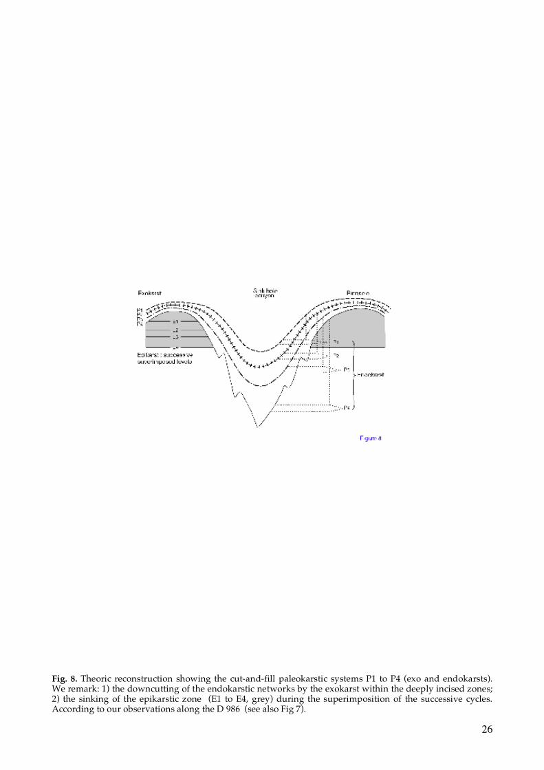
26
Fig. 8. Theoric reconstruction showing the cut-and-fill paleokarstic systems P1 to P4 (exo and endokarsts). We remark: 1) the downcutting of the endokarstic networks by the exokarst within the deeply incised zones; 2) the sinking of the epikarstic zone (E1 to E4, grey) during the superimposition of the successive cycles. According to our observations along the D 986 (see also Fig 7).

27
Fig. 9. Synthetic paleogeographic and paleomorphologic reconstruction, during Late Danian-Early Selandian, along a NNW-SSE transect indicated on Fig 1. The numbers correspond to the sites described in the text and located on the Fig 1.
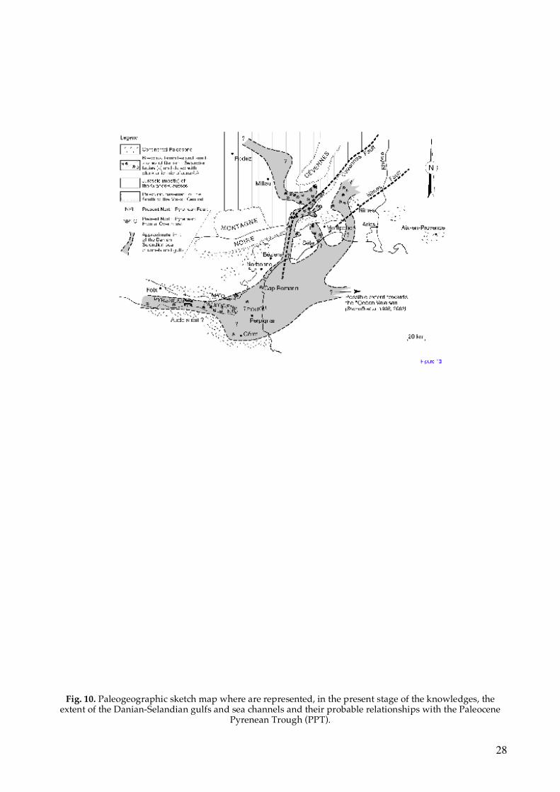
28
Fig. 10. Paleogeographic sketch map where are represented, in the present stage of the knowledges, the
extent of the Danian-Selandian gulfs and sea channels and their probable relationships with the Paleocene Pyrenean Trough (PPT).

29
Fig. 11. Sketches of the large Danian-Selandian endokarstic cavities studied within the quarries and roadworks of Bas-Languedoc.

30
Fig. 12. a) Grand Autas quarry. NS section of a large endokarstic gallery of the Paleocene surface P3 incised within the fractured Tithonian limestones. (See Fig 11 c for interpreted sketch). b) Idem, view of the same large gallery showing the R3 Paleocene internal sediment (laminated clays and sandstone). c) Idem, secondary gallery with the same internal sediment. The walls show dissolution scallops encrusted with Fe-Mn oxi-hydroxides. d) Idem, close-up view of the R3 internal sediment.

31
Fig. 13. a) La Madeleine quarry. EW section of a large endokarstic gallery filled up by marine Paleocene laminated clays. It was later partially excavated and filled up by marine bioclastic sediments (axial part of the cavity) whose the foraminifera content indicate a Late Burdigalian to Langhian age. (See Fig 11 d for interpreted sketch ). b) Bois de Lens quarry. EW section of a large endokarstic gallery, filled up by laminated sandy pelites of Paleocene age. The dark rim of the filling is due to a secondary alteration with Fe centrifugal migration. (See Fig 11 f for interpreted sketch).

32
Fig. 14. Synthetic chronodiagram showing the succession of the main events and depositional environments recorded to the North of Montpellier (road D 986) and in the Bas-Languedoc during Latest Cretaceous/Paleocene times.