geo-spatial-technologies, a trans-university new
TRANSCRIPT

GEO-SPATIAL-TECHNOLOGIES
“GEO-SPATIAL-TECHNOLOGIES",
a trans-university new integrative master degree
Wolfgang Sulzer Institute for Geography and Regional Science
University of Graz, AustriaHeinrichstrasse 36
A-8010 Graz, Austria

GEO-SPATIAL-TECHNOLOGIES
Table of Contents
Introduction
Team Members
Framework conditions
Curriculum
Conclusion and ongoing tasks

GEO-SPATIAL-TECHNOLOGIES
Introduction 1
Introduction
Present the curriculum of a trans-university master degree in Geo-Spatial-Technologies
To boost the discussion of such integrative studies (tension between Geography and Technical University studies)
To get known your experiences in such programs
“GEO-SPATIAL-TECHNOLOGIES”

GEO-SPATIAL-TECHNOLOGIES
Team Members
Team Members
Institute for Geography and Regional Science
Institute for Geoinformatics
Institute for Navigation and Satellite Geodesy
Institute for Photogrammetry and Remote Sensing
Institute for Digital Image Processing (Joanneum Research)
GEO-SPATIAL-TECHNOLOGIES
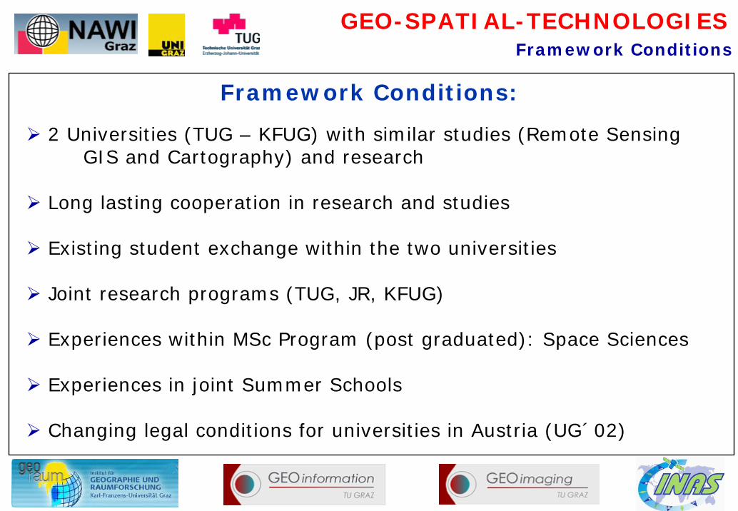
Framework Conditions:
2 Universities (TUG – KFUG) with similar studies (Remote Sensing GIS and Cartography) and research
Long lasting cooperation in research and studies
Existing student exchange within the two universities
Joint research programs (TUG, JR, KFUG)
Experiences within MSc Program (post graduated): Space Sciences
Experiences in joint Summer Schools
Changing legal conditions for universities in Austria (UG´02)
Framework Conditions

GEO-SPATIAL-TECHNOLOGIES
Focus existing expertise in research and teaching and to offer a joint master program
Cope an international and attractive Master Program
React on new trends in research and to bring into a study program
Combine existing lessons into something new
Get ahead of colleges
Benefits from existing teaching resources
Target group: students with geodetic and geographical backgroundand “geo-spatial” focus
Goal:
Framework Conditions

GEO-SPATIAL-TECHNOLOGIES
NAWI Graz stands for joint teaching, research and doctorate programmes in the field of the natural sciences at the scientific location of Styria.
Karl-Franzens-University and TU Graz created a milestone in their own histories by the showcase project which is one of its kind in Austria:
For the first time, two Austrian universities established a comprehensive strategic co-operation in research and teaching.
Co-operation instead of competition
Framework Conditions

GEO-SPATIAL-TECHNOLOGIES
Challenge 1
Complementary goals and expertises of involved institutions offer optimal prerequisites for join research activities
Synergies, which results from this cooperation can be used for joint integrative teaching purposes.
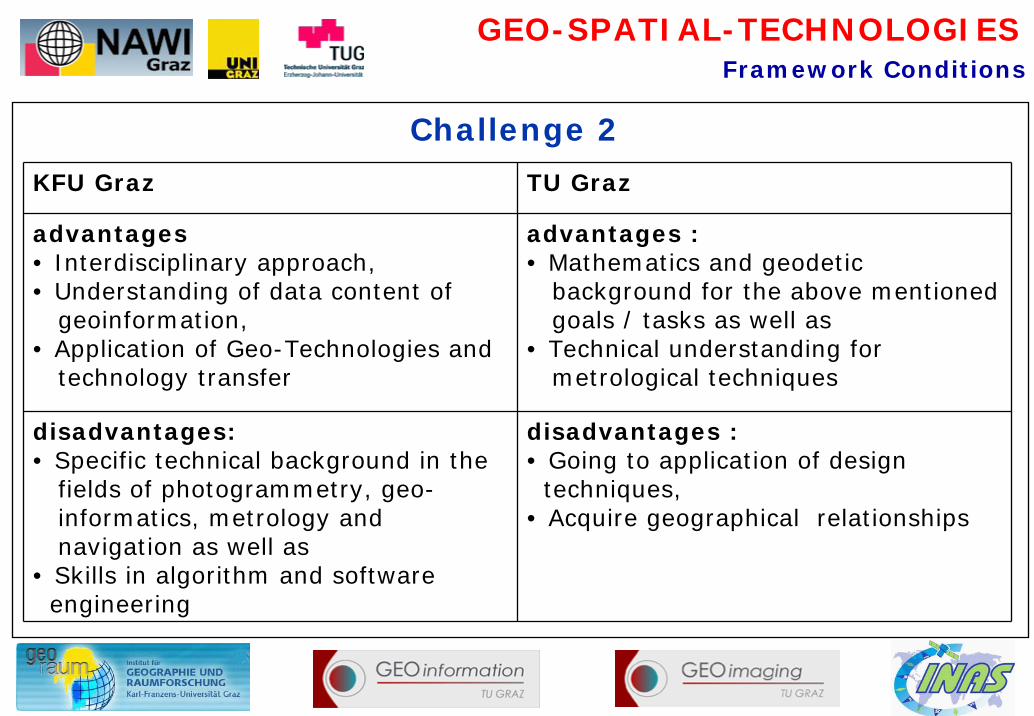
KFU Graz TU Graz
goals / tasks:Applications in Remote Sensing and GIS with geographical topics (Climate, regional sciences and planning, high mountain research, geomorphology, ecology, anthropogenic processes and structures, human and environmental spatial analyses)
goals / tasks: Development of algorithm and software for digital processing of remote sensing, photogrammetric data, for analyses modules of geoinformatics and for optimizing of measurements (close up photogrammetry and laserscanning)
Framework Conditions
GEO-SPATIAL-TECHNOLOGIES
KFU Graz TU Graz
advantages• Interdisciplinary approach,• Understanding of data content of
geoinformation, • Application of Geo-Technologies and
technology transfer
advantages :• Mathematics and geodetic
background for the above mentioned goals / tasks as well as
• Technical understanding for metrological techniques
disadvantages:• Specific technical background in the
fields of photogrammetry, geo-informatics, metrology and navigation as well as
• Skills in algorithm and software engineering
disadvantages : • Going to application of design
techniques, • Acquire geographical relationships
Challenge 2
Framework Conditions
GEO-SPATIAL-TECHNOLOGIES
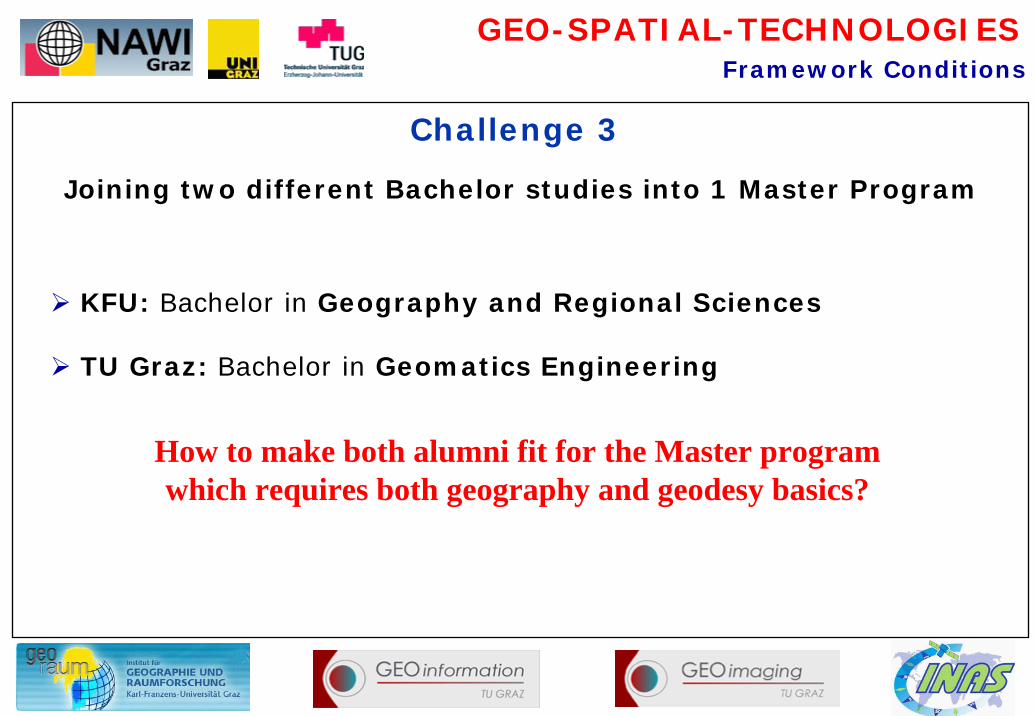
Challenge 3
Framework Conditions
KFU: Bachelor in Geography and Regional Sciences
TU Graz: Bachelor in Geomatics Engineering
How to make both alumni fit for the Master program which requires both geography and geodesy basics?
Joining two different Bachelor studies into 1 Master Program

GEO-SPATIAL-TECHNOLOGIES
Allocation to Geography (branch of study; TUG: DI, KFUG: MSC)
50% teaching on TUG and 50% teaching on KFUG
Integrate existing lessons of involved institutes (“no” additional costs!)
Compensation of different (Bachelor-) skills with defined additional lessons
Realisation 1
Framework Conditions

GEO-SPATIAL-TECHNOLOGIES
Realisation 2
Framework Conditions
October 2005 - an idea was born
March 2006: agreement about the content and curriculum within the team members (what should be the content)
April 2006 – June 2007: Finding legal agreement within different laws and to go through all official channels of the two universities !
June 2007: <curriculum passes both senates
Start: October 2007

GEO-SPATIAL-TECHNOLOGIES
Realisation 3
Framework Conditions
Harmonization of Master Level courses
Harmonisation of Bachelor Level courses in Cartography, Geoinformatics and Remote Sensing (with defined subject demands)
Adaptation of existing studying branches (Bc, MSc)
New integrative lessons

GEO-SPATIAL-TECHNOLOGIES
Curriculum 4 Semester:
Obligatory subjects ECTS
1. Acquisition and Management 15
2. Analyses 29
3. Presentation and Visualisation 11
4. Practical Course 8
5. (Selected) Subjects and Free Electives 15 +12
6. Master Thesis 30
Sum: 120
Curriculum

GEO-SPATIAL-TECHNOLOGIES
Acquisition and Management (15 ECTS) :
Data Acquisition and Integration
GPS Basics
Location Based Services (LBS)
GPS based data acquisition
Metadata
Interoperability
Curriculum

GEO-SPATIAL-TECHNOLOGIES
Analyses (29 ECTS):
Applied analysing techniques (GIS and RS); Network Analyses, object based classification, software engineering, laser scanning, ...
Applications of Remote Sensing (environ. Monitoring, urban planning, climatology, forestry, ...)
Curriculum

GEO-SPATIAL-TECHNOLOGIES
GIS and Internet
Kartographic Information Systems
3-D Visualisation
Presentation and Visualisation (11 ECTS):
Curriculum

GEO-SPATIAL-TECHNOLOGIES
Practical Course (8 ECTS):
Integrative Practical CourseWorkflow of an applied project (topics definition, data acquisition, integration, analyses, presentation, interpretation, ...)
Curriculum

GEO-SPATIAL-TECHNOLOGIES
Satellite Positioning
Projection Systems
Data Base Management
PhotogrammetryGeo- Mathematics
Cartography
Physical Geography
Human Geography
(Selected) Subjects (15 ECTS) and Free Electives (12 ECTS)
For Geographers (Bachelor):
For Geodesy (Bachelor):
Curriculum

GEO-SPATIAL-TECHNOLOGIES
Digital Cartography
Regional Planning
Satellite Geodesy/Navigation
Software Engineering
High Mountain and Climate Geography
Sustainable Urban and Regional Development
Photogrammetry and Remote Sensing
GeophysicsTo select 2 -3 subjects (min. 4 ECTS) !
Curriculum
(Selected) Subjects (15 ECTS)

GEO-SPATIAL-TECHNOLOGIES
Master Thesis (30 ECTS):
Applied topics
offer integrative master theses
linkage to Joanneum Research (DIP) and other research institutions
integration into international projects

GEO-SPATIAL-TECHNOLOGIES
Conclusion - Ongoing Processesmore adaptation and harmonization of curriculum contents
design of new integrative lessons
creation of a Virtual Lab to
• run a data and software server
• build up an e-learning platform
• minimize the spatial distance of the two Universities
• build up a centre for “Geo-Spatial-Technologies”
offer integrative master thesis
set up a joint doctor degree school
integrate international aspects of education (english, EU frameworks, etc.)
More information: www.uni-graz.at/geowww

GEO-SPATIAL-TECHNOLOGIES
Thank you for your attention !