geo and geoss…….asian-gwadi.westgis.ac.cn/wp-content/uploads/2013/09/2013_09_16...ceop aegis...
TRANSCRIPT

© GEO Secretariat
GEOSS and GEO Cold Regions - An information framework for observations in Polar and Mountain areas
16 Sep, 2013
Beijing, China
Yubao Qiu
GEO Secretariat

Short data spans of satellite data Biases associated with instrument Uncertainties in retrieval algorithms
Wang et al., 2012, Clim. Dynam
“wet-gets-wetter”
Precipitation

U.S. Department of State
Washington DC
31 July 2003
The Group on Earth Observations (GEO)
Earth Observation Summit

To realize a future wherein decisions and
actions, for the benefit of humankind, are
informed by coordinated, comprehensive and
sustained Earth observations and information.
GEO Vision

•Improve and Coordinate Observation Systems
•Advance Broad Open Data Policies/Practices
•Foster Increased Use of EO Data and Information
•Build Capacity
GEO Objectives

Created in 2005, to develop a coordinated and sustained
Global Earth Observation System of Systems (GEOSS) to
enhance decision making in nine Societal Benefit Areas
(SBAs)
GEO today:
90 Members
67 Participating
Organizations

© GEO Secretariat
67 Participating Organizations

A Global, Coordinated, Comprehensive and Sustained System of Observing Systems

Space-based Assets

In-situ Systems


© GEO Secretariat
Ecosystem Classification & Mapping (Australia, Austria, Brazil, Canada, China, EC,
Italy, Paraguay, USA, RCMRD, UNESCO)
* SHARE mountain stations operational
* All ecosystem mapping data available; DataCORE
* New maps of growing season
* Atlas of 40 Chinese World Heritage Sites
* Decision-making support: ABCC program

* New GEO proposal adopted by G20 (Cannes, 3-4 Nov 2011)
* Inter-comparisons of agricultural modeling & monitoring methods
* 7 pilot sites in Argentina, Canada, China, Europe and Mexico
* 2 new pilot-sites in Brazil
* Satellite data acquisition coordinated with CEOS
FASAL - India
Improved Crop Management (Argentina, Brazil, Canada, China, EC, France,
India, Mexico, Russia, South Africa, USA, FAO)

Forest Carbon Tracking (Australia, Canada, Japan, Norway, USA, CEOS, FAO)
From 2009: • Brazil • Guyana • Mexico • Indonesia (Borneo) • Australia (Tasmania) • Cameroon • Tanzania
New projects contributed:
* US SilvaCarbon * European FP7 RECOVER, REDDAF, REDD-FLAME, REDDINESS
From 2010/2011:
• Colombia
• Congo
• Peru
• Indonesia (Sumatra)
• Nepal (2011)
Network of National Demonstrators

Regional Center for
Tropical Forest Monitoring (Brazil, France, Italy, Japan, FAO)
* Training in 3 languages (English, Spanish, Portuguese)
* Open-source software
* Over 60 people trained from 18 countries
* Results directly applied by Congo

© GEO Secretariat
More Carbon Information (Australia, China, EC, France, Italy, Japan,
Netherlands, UK, USA, CEOS, ESA, GTOS, WMO)
* Ground-based Carbon
datasets released
(FLUXNET, TCCON)
* Essential for calibration/
validation of satellite data
* New European projects
launched for estimating
regional CO2 and CH4
sources & sinks
* GEO Carbon Strategy

© GEO Secretariat
Next Generation CBERS (Brazil, China, Egypt, France, Gabon, Italy,
Spain, South Africa)
* 70% of CBERS data
available online
* Ground stations
upgraded to receive/
process CBERS-2B
* New ground station
in Gabon
* MoUs signed with
Spain and South Africa
for CBERS-3 reception
(launch in Q1 2012)

Global Fire-Danger Systems (Canada, Germany, Russia, GTOS, ISDR)
* Prototype global early-warning system operational
* Regional fire systems for Eurasia, Europe, southern Africa developing
* 400 weather station data processed daily for fire-potential maps

© GEO Secretariat
New Flood Warning Systems (Canada, Germany, Namibia, Ukraine, USA, UNOOSA)
* Launched during
Namibian floods of
January-April 2011
* Rapid dissemination of
space-based & ground-
sensor products
* Flood warnings issued
to local populations
* To be extended to
southern African regions

© GEO Secretariat
GEO Biodiversity Observation Network (Australia, Denmark, Greece, India, New Zealand,
Portugal, South Africa, USA, Diversitas, GBIF)
* GEOBON key contributor to Convention on Biological Diversity (CBD)
* Evaluation of existing capabilities for protecting biodiversity by 2020
* Country maps of native and invasive species

GEONETCast Expanded (China, EC, Netherlands, USA, EUMETSAT)
* New dissemination
of disaster imagery
(agreement with
International Charter)
* Growing network of
stations: Africa, Asia,
Americas
* CMACast – Next
generation update
* Toolbox, training
channels, e-courses

© GEO Secretariat © GEO Secretariat
More Water Information(Austria, EC, Germany, Japan, USA,
CEOS, ESA, WCRP, WMO)
* Global high-res precipitation
datasets 1979-2010
* New SMOS products & soil
moisture datasets 1978-2010
* Satellite data validation
* Global Drought Information
System underway
* Asian/African Water Cycle
Initiative
Soil Moisture (SMOS, ESA)
Precip

Push the way for the GEO Dry-land Observation Network (Now…)
• UNCCD,
Rio+20 outcomes literally states: “We reaffirm our resolve under the United Nations Convention to Combat Desertification (UNCCD) to take coordinated action nationally, regionally and internationally, to monitor, globally, land degradation and restore degraded lands in arid, semi-arid and dry sub humid areas”; what this statement may help open a new window for addressing global monitoring UNCCD.
Rio+20 outcomes: The Zero-net land degradation (ZNLD) could have on a renewed interest on land-related issues in the global environmental agenda. Clearly without a strong monitoring system, the idea of ZNLD will fail.

GEOSS Implementation requires: Data Sharing Principles
• Full and Open Exchange of Data
• Data and Products at Minimum Time delay and
Minimum Cost
• Free of Charge or Cost of Reproduction
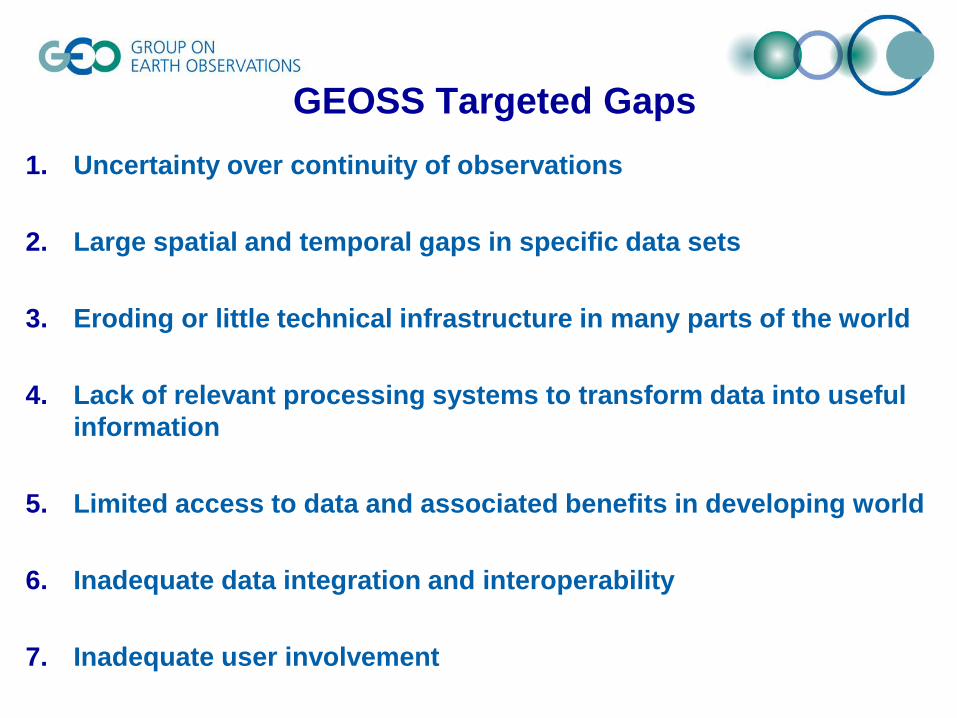
1. Uncertainty over continuity of observations
2. Large spatial and temporal gaps in specific data sets
3. Eroding or little technical infrastructure in many parts of the world
4. Lack of relevant processing systems to transform data into useful
information
5. Limited access to data and associated benefits in developing world
6. Inadequate data integration and interoperability
7. Inadequate user involvement
GEOSS Targeted Gaps


Interoperability Brokers

Introduction of the
Brokering approach

Achievements


© GEO Secretariat
Link/Foster the Cold Regions Monitoring (Canada, China, Denmark, Germany, Norway, India, Italy,
Japan, Spain, Switzerland, USA, ICIMOD, IEEE, WCRP, WMO)
* CryoClim climate
monitoring service
* Svalbard Integrated Arctic
Earth Observing System
* Sea-ice ECV for Arctic/
Antarctic snow-cover
* Focus on Tibetan Plateau
* Glacier dynamics mapping

Why - Cold Regions Its CORE are the Cryospheric Components
It includes snow, sea ice, lake and river ice, glaciers, ice caps, ice sheets,
permafrost and seasonally frozen ground, and solid precipitation
Disaster Energy Climate Water Health Weather Ecosystem Agriculture Biodiversity
GEO nine Societal Benefit Areas
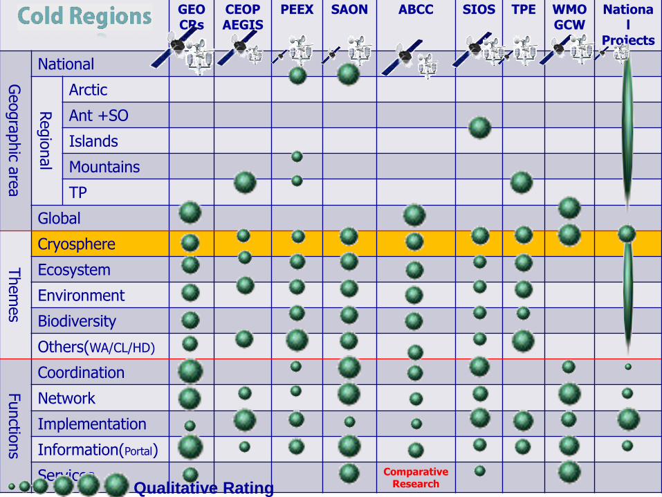
GEO CRs
CEOP AEGIS
PEEX SAON ABCC SIOS
TPE WMO GCW
National
Projects
Geogra
phic a
rea
National
Regio
nal
Arctic
Ant +SO
Islands
Mountains
TP
Global
Them
es
Cryosphere
Ecosystem
Environment
Biodiversity
Others(WA/CL/HD)
Functio
ns
Coordination
Network
Implementation
Information(Portal)
Services Comparative Research Qualitative Rating

Jeff Key @PSTG3
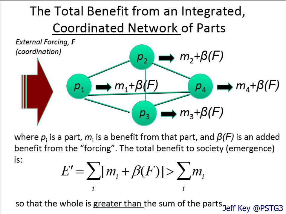
Jeff Key @PSTG3

Jeff Key @PSTG3

Jeff Key @PSTG3

GEO Cold Regions (CoP / Advisory Board)
GEOSS
Communities (Users and Stakeholders)
Infrastructure (Broker/GCI)
Data Sharing Principle (Support)
Plenary (Decision Makers)
Ministerial Summit
Partnerships (Systems)
Projects
Programs
Networks/Coordinations
The Third Part
Partnerships (FUTURE EARTH,
CLIC/WCRP…)
GEO Cold Region
Cross Cutting Task
SBAs
Short/ Long Term Activates/
National/Institutional effort
/Projects
A draft to address the coordination
(Information Service for cold Regions)
Space (Satellite/Airborne)
In-situ
model output (assimilation)
DA
TA
Information
Water-Ecosystem/Biodiversity-Climate-Environment

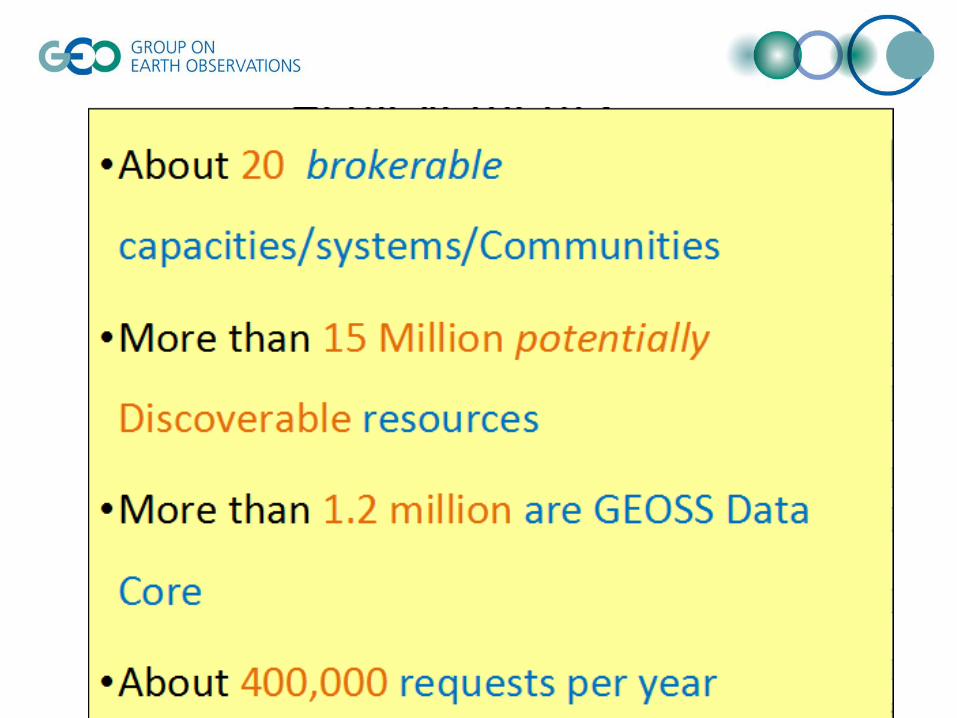
Specific Themes Now GCI provides the “raw” and “all”
combinations of GEO Data
Resources, now with millions of records and URLs. While it is not
easy for those who are working on the applications.
Idea GCI likes a “raw” data pool,
applications are specific, the virtual layer provide a professional interface to the applications
Requirement An Programmable GCI : Based on
the GCI, create a virtual layer of portal (interface)
Benefit Data pledge /Users engagement :
more operational for the users and specific theme applications
GEOBON GFOI
Others
Applications
Data Pools
virtual layer of portal
3
2
1

Recent Progress - 2013
• Building on the Past and Existing Activities
• Enhance the Arctic Data/Information coordination for Cold Regions by international programs (SAON, SIOS, PEEX, INTERACT, ABDS-ABA/CAFF, Cryoclim) and National/Institutional programs/Projects (China, Germany, Italy, and Switzerland)
• Remote Sensing of Antarctic - Land Cover and Mapping
• Initialize the coordination of the lower latitude Mountain Cold Regions observation activities (with EC-01 part) via in-situ and satellite observation and application, for example, SHARE/NextData Network, CEOP-AEGIS, TPE, ICIMOD, IMIS/SwissEx and etc.
• Satellite Data Coordination Support
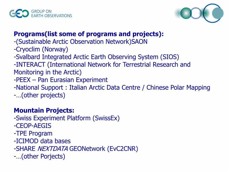
Programs(list some of programs and projects): -(Sustainable Arctic Observation Network)SAON -Cryoclim (Norway) -Svalbard Integrated Arctic Earth Observing System (SIOS) -INTERACT (International Network for Terrestrial Research and Monitoring in the Arctic) -PEEX – Pan Eurasian Experiment -National Support : Italian Arctic Data Centre / Chinese Polar Mapping -…(other projects)
Mountain Projects: -Swiss Experiment Platform (SwissEx) -CEOP-AEGIS -TPE Program -ICIMOD data bases -SHARE NEXTDATA GEONetwork (EvC2CNR) -…(other Porjects)

Arctic
Global
Observing
Arctic and Global Value-added Services & Societal Benefits
Decision-
Making
Policy-
Making
Scientific
Research
& Education
Forecasting
& Prediction
Data
Products
Arctic
Observing
Operational
Observing
(international
and national)
Research
Observing
Community-based
Observing;
Local & Traditional
Knowledge
A Gateway to Arctic Data
Building Blocks SAON
1 2 3 4 5 etc.
SAON will promote coordination & improved services

WMO
The IGOS Cryosphere Theme was developed primarily to assess current capabilities and requirements for cryospheric observations
Over 100 recommendations provide the basis for subsequent actions. But who will take action?
2008
Global Cryosphere Watch (GCW)
The CORE of Cold Region – WMO-GCW Development
by GCW

Third Pole Environment Database

Pan Eurasian Experiment
In-situ Measurement Built on existing network
atmospheric measurements

Antarctic Landcover v1.0

Cold region specific data of the Swiss Federal Institute for Forest, Snow and Landscape Research (WSL)
IMIS network Cryosphere Data: -166 stations over Switzerland -221 observers nationwide reporting weather and snow parameters -Some research data contains long time-series (Weissfluhjoch: 75 years) Ecological Data
Swiss Experiment Platform (SwissEx)

Space Observation Support to the Polar programs
• Polar Space Task Group support etc…

Comparative Study on Global Environmental Change Using Space Technology (ABCC)
To establish a cooperative relationship among the Participants in the use of Earth Observation science and technology in the study of global change, on the basis of equality, reciprocity and mutual benefit.

Activities and workshops • Joined the 2nd and 3rd Boarding meeting for SAON, 2012~2013
• Join the 2nd and 3rd PSTG meeting, Geneva, 2012~2013
• ECPORS IV / WMO, Lanzhou, 2013
• EO4Cryosphere, ESRIN, 2012
• GEO WATGLOBS meeting, April, 2013
• WebEx and Consultative side meetings, 2012~2013
• Arctic Observation Summit, Vancouver, 1-3 May, 2013
• The GEO Cold Regions Leads held a Webex meeting, 22, May, 2013
• GEO Cold Regions Meeting/Workshop, Geneva, 3rd, June,2013
• Polar Data base meeting, Oct., 2013
• Joint effort with the WMO/GCW at Dce., 2013
• GEO X Ministerial Summit / Plenary activities: side meeting or exhibition and Poster in Booth, Jan, 2014
• AOS, Helsinki, Finland, 2014 – Co-Sponsor

http://www.earthobservations.org