general geotechnical subsurface soils evaluation …€¦ · section 2.0 – general subsurface...
TRANSCRIPT

PREPARED FOR
CEA GROUP 4712 WOODROW BEAN, SUITE F
EL PASO, TEXAS 79924
GENERAL GEOTECHNICAL SUBSURFACE SOILS EVALUATION REPORT
FOR
EPW – SUNSET HEIGHTS WATER & SANITARY SEWER REPLACEMENT PROGRAM PHASE 18
PROJECT EL PASO, EL PASO COUNTY, TEXAS
CQC PROJECT NO. AGCQC19-014
CQC TESTING AND ENGINEERING, L.L.C. TBPE FIRM REGISTRATION NO. F-10632 4606 Titanic Ave. EL PASO, TEXAS 79904 PH.: (915-771-7766 FX.: (915) 771-7786
Local El Paso, Texas Firm


General Geotechnical Subsurface Soils Evaluation Report EPW – Sunset Heights Water & Sewer Replacement Phase 18 Project Upson Drive from Heights Avenue to Prospect Drive El Paso, El Paso County, Texas
CQC Project No. AGCQC19-014 CQC Testing and Engineering, L.L.C. May 21, 2019 TBPE Firm Registration No. F-10632 Page 1 of 23 (Final Issued Report Date: 8/27/19)
Report Table of Contents
Page No.
Section 1.0 – General Project Information 3 1.1 Site Geologic Considerations 3 1.2 Existing Site Topography and Vegetation 4 1.3 Seismic Considerations 5 Section 2.0 – General Subsurface Soils Evaluation 5 2.1 Laboratory Engineering Soil Classification Testing 7 2.2 Soil Moisture-Density Relationship Test Results 7 2.3 Soil California Bearing Ratio (CBR) Test Results 7 Section 3.0 – Encountered Subsurface Soil Conditions 8 3.1 Groundwater Depth Considerations 10 3.2 Subsurface Soil Considerations and Preparation 11 - Special Considerations
- Site Preparation 3.3 Drainage Considerations 13 Section 4.0 – Soil Bearing Capacity and Design Considerations 13 4.1 Water & Sewer Line Replacement Design Considerations 13 4.2 Earth and Vehicle Loads 13 Section 5.0 – Below Grade Lateral Earth Pressures 13 Section 6.0 – General Trench Safety Considerations 14 6.1 Trench Safety Considerations 15 Section 7.0 – Pipe Embedment and Backfill Considerations 16 7.1 Man Hole Structures Considerations 17 Section 8.0 - Pavement Improvement Recommendations 18
Section 9.0 – Additional Design and Construction Considerations 19
Section 10.0 – Project Specification Information 19 10.1 Fill Materials 19 10.2 Construction Materials Testing 22 Section 11.0 – Soils Evaluation Considerations and Limitations 22

General Geotechnical Subsurface Soils Evaluation Report EPW – Sunset Heights Water & Sewer Replacement Phase 18 Project Upson Drive from Heights Avenue to Prospect Drive El Paso, El Paso County, Texas
CQC Project No. AGCQC19-014 CQC Testing and Engineering, L.L.C. May 21, 2019 TBPE Firm Registration No. F-10632 Page 2 of 23 (Final Issued Report Date: 8/27/19)
List of Appendices
Appendix A Sheet No. General Geotechnical Subsurface Exploration Boring Location Aerial Plan A1-1
City of El Paso Flood Zone Aerial Plan A1-2
Vertical Exploration Boring Logs A2-A9
Particle Size Analysis Test Reports A10-A17
Summary of Field & Laboratory Test Results A18-A19
Moisture-Density Relationship Test Results A20-A23
California Bearing Ratio Test Results A24-A25
Subsurface Diagram Profile A26
Appendix B
Geotechnical Report Technical Reference Information B1
Soil Classification Chart B2
Geotechnical Report Soil Classification Reference Information B3
Appendix C
Selected Project Field Work Photographs C1

General Geotechnical Subsurface Soils Evaluation Report EPW – Sunset Heights Water & Sewer Replacement Phase 18 Project Upson Drive from Heights Avenue to Prospect Drive El Paso, El Paso County, Texas
CQC Project No. AGCQC19-014 CQC Testing and Engineering, L.L.C. May 21, 2019 TBPE Firm Registration No. F-10632 Page 3 of 23 (Final Issued Report Date: 8/27/19)
Section 1.0 – General Project Information
This general geotechnical subsurface soils evaluation report has been prepared for CEA Group
(Client) for the El Paso Water – Sunset Heights Water and Sanitary Sewer Replacement Program Phase
18 Project. The project consists of the design and installation of approximately 3,400 linear feet of an 8-
inch water and 24-inch sanitary sewer lines along Upson Drive from Heisig Avenue to Prospect Drive in
central El Paso, El Paso County, Texas. We understand that the pipeline invert depths for the water line
shall range from 5 to 7 feet and the sanitary sewer line depth shall be about 12 feet, below the existing
pavement surface elevations.
Our specific scope of services for this project consisted of generally evaluating the subsurface soil
conditions along the proposed new pipeline areas by collecting subsurface soils information, conducting
Standard Penetration Tests (SPT’s), and preparing soil related information with respect to the suitability of
the on-site soils, engineering soil classifications, bearing resistance, and potential construction use for
pipeline backfilling. Please note that an additional scope of work was requested by our Client to perfom
additional borings within the project area. The results of these additional exploratory borings are
represented as B-7 and B-8. Our additional scope of work was authorized in response to CQC’s proposal
no. AGCQC18-073-01 dated May 22, 2019.
The following sections of this report present our field evaluation methods, site soil-related
considerations, estimated allowable bearing capacity values, and guidance information with respect to site
preparation, structure embedment, soil backfilling, and trench safety considerations. Please note that the
entire report should be read for a thorough understanding of our evaluation, findings, and guideline
recommendations. CQC Testing and Engineering, L.L.C. (CQC) should be contacted through a written
statement if our stated understanding of the project is not correct and/or if the owner changes the proposed
water and sewer line areas for this project. Site and pipeline route changes may result in our information
and recommendations within this report to be invalid without further review and evaluation by CQC. This
is especially true for this project due to the very hard subsurface conditions encountered within the
exploration vertical borings completed for this project.
1.1 - Site Geologic Considerations
The Geologic Atlas of Texas (Van Horn-El Paso Sheet, Revised 1995) published by the Bureau of
Economic Geology at the University of Texas at Austin indicates that that the project site is located in an
area of Young Quaternary deposits near the foothills of the Franklin Mountains. These formations typically
consist of areas of colluvium and alluvium deposits of silt, sands, gravels, clays, caliche and gypsum. The

General Geotechnical Subsurface Soils Evaluation Report EPW – Sunset Heights Water & Sewer Replacement Phase 18 Project Upson Drive from Heights Avenue to Prospect Drive El Paso, El Paso County, Texas
CQC Project No. AGCQC19-014 CQC Testing and Engineering, L.L.C. May 21, 2019 TBPE Firm Registration No. F-10632 Page 4 of 23 (Final Issued Report Date: 8/27/19)
geologic atlas also indicates that “Lanoria Quartzite” formation outcroppings shall also be encountered
within the vicinity of the project area. The project area also contains exposed Andesite rock outcroppings
and shallow fractured bedrock formations. The deposition of the rock formations shall vary horizontally and
vertically along the project pipeline routes. Cross bedding with alluvium formations shall be expected. It is
also possible to encounter very hard cemented calcareous soil formations within the project area as well.
Excavations through the sandy and gravelly soil and fractured rock formations in the area shall
require relatively heavy equipment to perform excavation operations. The geologic map also indicates that
fault zones are located northwest of the general project areas. Section 3.0 of this report presents additional
excavation considerations, especially with respect to handling of rock excavations to reach the specified
pipeline invert depths.
Based on the City of El Paso floodplain maps, the project areas are located outside of the floodplain
area. This should be verified by the project civil engineer. The Flood Zone Map can be found in Sheet A1-
3 for ease of reference. Please note that the indicated flood plain paths on the exhibit may not represent
the exact flood plain path locations and shall vary. This shall be further evaluated with a topographic survey
and drainage analysis.
It has been reported that no significant ground movement caused by the existing faults has been
recorded for the past 50 years in the El Paso area. Although the local seismic observatory at the University
of Texas at El Paso (UTEP) has indicated that the frequency of recordable ground movements has
increased within the last few years.
Please note that our scope of work did not include the specific delineation of faults within the project
construction limits and/or the development of specific design recommendations over faults zones.
However, these services may be provided as an additional scope of work and service to our Client, if
required.
1.2 – Existing Site Topography and Vegetation
Based on general site observations, the areas within the project limits appear to exhibit varying
elevation changes. The pipeline route areas are paved with a flexible pavement structure and bounded by
single and two-story residential buildings. The University of Texas at El Paso Campus and Mundy Park
facility are in the vicinity of the project areas.
CQC was not provided any historical or current topographic survey plans, design plans,
construction reports or environmental reports for review from our Client. Therefore, CQC has no

General Geotechnical Subsurface Soils Evaluation Report EPW – Sunset Heights Water & Sewer Replacement Phase 18 Project Upson Drive from Heights Avenue to Prospect Drive El Paso, El Paso County, Texas
CQC Project No. AGCQC19-014 CQC Testing and Engineering, L.L.C. May 21, 2019 TBPE Firm Registration No. F-10632 Page 5 of 23 (Final Issued Report Date: 8/27/19)
knowledge if previous site excavations or fill were appropriately backfilled with suitable soils and tested for
compaction verification.
1.3 – Seismic Considerations
Based on our review of the current International Building Code and Site Classification for Seismic
Design Definitions in conjunction with our review of the geologic conditions in the area, it is our professional
opinion that a Site Class C may be considered for this project. Please note that a geologic atlas of the
area was used to supplement our analysis since our borings were performed to maximum depth of 15 feet
below the existing ground surface elevation and the building code considers the average soil properties in
the top 100 feet of the subject site. In the event that the owner and/or design representative is interested
in determining the building code Site Class with a higher degree of accuracy, additional tests beyond our
original requested scope of work shall be required.
Based on a Soil Site Class C, seismic ground motion values were determined based on a site
latitude coordinates and longitude coordinates at the general center area of the project limits are defined
in the table below. The seismic coefficients were generated through the USGS Seismic Hazard Design &
OSHPD Seismic Design Maps website. The values should be verified by the project structural engineer
prior to use in structural analysis. CQC should be informed if the reported values vary significantly.
Table 1 – Seismic Ground Motion Values
Borehole No. Latitude Longitude
(-) Period
(Seconds)
Spectral Accelerations
(g)
Site Coefficient
Fa
Site Coefficient
Fv
B-1 thru B-6 31.762362 106.499875 0.2 (Ss) 0.273 1.20 -
1.0 (S1) 0.121 - 1.693
Section 2.0 – General Subsurface Soils Evaluation
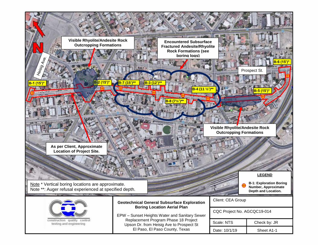
As requested by our Client, the subsurface soils along the proposed pipeline alignments were
evaluated by completing a total of eight (8) exploration vertical borings performed at the approximate
locations shown in the General Geotechnical Subsurface Exploration Boring Location Aerial Plan, Sheet
A1-1.
The borings were drilled with a rotary drilling rig (CME-75) and hollow stem auger drilling techniques
and were logged during our field operations by a member of our geotechnical engineering staff. Our boring
logs are presented in Sheets A-2 through A-9. In general, the borings were drilled from an auger refusal
depth of 7½ feet to a maximum depth of 15 feet, below the existing flexible pavement elevation. During

General Geotechnical Subsurface Soils Evaluation Report EPW – Sunset Heights Water & Sewer Replacement Phase 18 Project Upson Drive from Heights Avenue to Prospect Drive El Paso, El Paso County, Texas
CQC Project No. AGCQC19-014 CQC Testing and Engineering, L.L.C. May 21, 2019 TBPE Firm Registration No. F-10632 Page 6 of 23 (Final Issued Report Date: 8/27/19)
our drilling operations Standard Penetration Tests (SPT’s) were performed in general conformance with
ASTM D 1586. Soil samples were collected within a split-spoon sampler at discrete depth intervals and
were containerized and transported to our laboratory for further physical and classification testing. Our
laboratory engineering soil classification tests (i.e., moisture contents, sieve analysis, and Atterberg Limit
Tests) were performed in accordance with accepted ASTM test procedures D 2216, D 1140, D 2217,
D6913, and D 4318, respectively. In general, the results of our tests and estimated “N-Values” are
presented in our boring logs and Summary of Laboratory Engineering Soil Classification Test Results in
Sheets A18 and A19. At the completion of our subsurface exploration activities, the borings were backfilled
with soil cuttings, firmly compacted and patched with concrete at the ground surface.
The following table summarizes the completion depth of our borings, type of samples, and number
of collected samples at the time of our subsurface exploration activities.
Table 2 – Summary of Field Evaluation – Boring Depths & Samples Collected
Summary of Subsurface Exploration Evaluation
Borehole No. Approximate Termination
Depth (ft.)
No. Split-Spoon
Samples
No. Grab Samples
Observed
Groundwater Depth (ft.)
B-1 15 4 - NE
B-2 15 3 - NE
B-3* 12 6 - NE
B-4* 11½ 2 - NE
B-5 15 1 - NE
B-6 15 4 - NE
B-7* 13 ½ 6 - NE
B-8* 7 ½ 4 - NE
NE- Not encountered at the time of our drilling activities. Note *: Auger refusal experienced at this depth during field exploration activities.
Contractors interested in bidding the project shall perform their own tests to verify the types of
materials or review historical plans of the area to evaluate the excavation requirements prior to bidding the
project. The owner shall not incur additional costs for additional excavations or removal of encountered
variable unclassified soils, heavy equipment required to penetrate the encountered subsurface soil/rock
formations, buried materials or utilities.
Please note that the collected soil samples from our soils evaluation shall be stored for a period of
up to 60 days after the submittal of this report, if a longer period of storage is required by our client, CQC
should be informed in writing.

General Geotechnical Subsurface Soils Evaluation Report EPW – Sunset Heights Water & Sewer Replacement Phase 18 Project Upson Drive from Heights Avenue to Prospect Drive El Paso, El Paso County, Texas
CQC Project No. AGCQC19-014 CQC Testing and Engineering, L.L.C. May 21, 2019 TBPE Firm Registration No. F-10632 Page 7 of 23 (Final Issued Report Date: 8/27/19)
2.1 - Laboratory Engineering Soil Classification Testing
In the laboratory, selected soil samples were evaluated and visually classified by our geotechnical
engineering staff in general accordance with the Unified Soil Classification System (USCS). The
geotechnical engineering properties of the selected samples were evaluated by the following tests.
Table 3 – Summary of Performed Laboratory Engineering Classification Tests
Type of Test
Total Number Conducted
Soil Moisture Contents 19
Atterberg Limit Tests 17
Particle Size Analysis Tests 19
Moisture-Density Relationship Tests 4
California Bearing Ratio (CBR) Tests 2
Our selected particle size sieve analysis test results are reported in Appendix A, Sheets A10
through A17 in this report.
2.2 – Soil Moisture-Density Relationship Test Results
At the time of our drilling activities, four (4) bulk soil sample was obtained from the reported boring
locations for soil moisture-density relationship testing. The samples were collected during our drilling
activities from auger cuttings from approximately the ground surface to approximately 7 feet. The test
results are reported in Sheets A20 through A23. A summary of the results are presented in the table below.
Table 4 – Summary of Soil Moisture-Density Relationship Test Results
Borehole No.
Approx. Sample
Depth (ft)
ASTM D 1557,
Method Soil Classification
Plasticity Index
Opt. Dry
Density (pcf)
Opt. Moisture (%)
B-1 1 - 3 C SP-SM NP 137.6 5.2
B-3 1 - 3 C SM NP 137.6 5.2
B-5 5 – 7 C SC 21 142.2 5.6
B-6 1 - 5 B SC 10 134.7 6.5
2.3 – Soil California Bearing Ratio (CBR) Test Results
The results of two (2) California Bearing Ratio (CBR) test conducted on a collected samples from
boring locations B-1 and B-5 are presented in the table below and Sheets A24 and A25. The tests were
performed in general accordance with ASTM standard test method D 1883. Based on our CBR test results,

General Geotechnical Subsurface Soils Evaluation Report EPW – Sunset Heights Water & Sewer Replacement Phase 18 Project Upson Drive from Heights Avenue to Prospect Drive El Paso, El Paso County, Texas
CQC Project No. AGCQC19-014 CQC Testing and Engineering, L.L.C. May 21, 2019 TBPE Firm Registration No. F-10632 Page 8 of 23 (Final Issued Report Date: 8/27/19)
the soils at the sample location shall provide a relatively high level of support for the new replacement
pavement section along the removed pavements.
Table 5 – Summary of California Bearing Ratio (CBR) Test Results
Borehole No.
Sample Depth (ft)
Dry Density prior to Soaking
(pcf)
Dry Density
after Soaking
(pcf)
Swell % CBR at
0.1” Pen. CBR at
0.2” Pen. Support
Level
B-1 1 - 3 129.9 125.1 0.0667 63 60 High
B-5 5 – 7 136.6 131.5 0.2889 69 84 High
Section 3.0 – Encountered Subsurface Soil Conditions
Based on our soil classifications and laboratory tests, the subsurface soils encountered in our
exploration borings may be described by five (4) generalized soil and/or rock types. In order to gain access
to the subsurface soils at each boring location, we cored thru an existing 2 to 4 inches thick asphaltic
concrete pavement over 1 to 4 inches of apparent base course material. The logged depths of the reported
soil formation types are approximately delineated in our exploration vertical boring logs. Our boring logs
are presented in Appendix A of this report. Due to the geologic location of the site, it is possible for
variations in the types and depths of the soil formations to occur over relatively short distances, this is
specifically true of the potential geologic conditions that may be encountered along the water pipeline
route.
Table 6 – Summary of Subsurface Soil Classification & Strength
Type General
Description
Consistency (SPT Blow
Counts)
Moisture Content (%)
Atterberg Limits %Passing
No. 200 USCS
Classification Plastic Limit
Plasticity Index
I
Fine to Coarse Grained
Gravelly with clay lumps and
silt
Loose to Very Dense (8 to >50)
2.0 to 6.0 Non- Plastic 9 to 12 SP-SM
Remarks: These soils shall be susceptible to soil sloughing during excavations.
II
Fine to Coarse Grained,
Gravelly with clay lumps
Loose to Very Dense
(7 to 62) 5.0 to 7.0 Non-Plastic 14 to 42 SM
Remarks: These soils shall be susceptible to soil sloughing during excavations. Shall require heavy equipment to perform excavations through this formations.

General Geotechnical Subsurface Soils Evaluation Report EPW – Sunset Heights Water & Sewer Replacement Phase 18 Project Upson Drive from Heights Avenue to Prospect Drive El Paso, El Paso County, Texas
CQC Project No. AGCQC19-014 CQC Testing and Engineering, L.L.C. May 21, 2019 TBPE Firm Registration No. F-10632 Page 9 of 23 (Final Issued Report Date: 8/27/19)
III
Fine to Coarse Grained,
Gravelly with clay lumps
Medium Dense to Very Dense (11 to > 50)
5.0 to 16.0 27 to
59 9 to 36 20 to 32 SC
Remarks: This formation was encountered in borings B-4, B-5 and B-6, interbedded below Type I and II soils.
These soils shall be blended with suitable relatively non-plastic sands to meet the Select Fill Requirements. Blending and screening shall be required to reduce the plasticity of the native clayey soils and to remove particles greater than 1½ inches
IV
Well Graded or Silty, Fine,
Subangular with sand and clay
lumps
Loose to Very Dense
(8 to 82)
3.0 to 4.0
Non-Plastic
9 to 16
GM, GW-GM
Remarks: This formation was encountered in borings B-4 and B-5, interbedded below Type I and III soils. These formations shall require heavy equipment to perform excavations. Screening and/or blending of these formations shall be required to meet the Select backfill material specifications (i.e. Select Fill, Class II and Class III backfill soil materials.
V
Andesite or Rhyolite Rock
Very Dense to Hard (< 50)
-
Non-Plastic
-
Rock
Remarks: This formation was encountered in borings B-7 and B-8, interbedded below Type I and III soils.
These formations shall require review of the pipeline excavations section within this report.
We encountered auger refusal within the areas represented by borings B-2 and B-3 to depths
ranging from 11 ½ to 12 feet below existing pavement surface. We shall note that andesite rock deposits
are anticipated to be encountered at these depths. We also noted rock outcrops to the north of boring
location B-2. Andesite rock was encountered at approximately 6 ½ and 12 ½ feet in our supplemental
vertical borings B-7 and B-8. In addition auger refusal was experienced at 7 ½ and 13 ½ feet in B-7 and
B-8 borings.
A two-dimensional surface diagram of the borings is presented in Sheet A26 for general review of
the encountered subsurface soil and/or rock conditions. The boring surface diagram was developed for
the primary purpose of generally evaluating the potential subsurface soil/rock conditions that shall be
encountered within the project limits.
Pipeline Excavations
Bidding general contractors shall consider that rock excavation shall be required along the specified
water and sewer line excavations to meet the specified pipeline invert depths. The geotechnical boring logs
may be reviewed at the bidding contractor’s discretion for estimation of potential areas where rock formations
shall be encountered and means and methods to perform excavations. Contractor shall be responsible for
collecting additional subsurface date as deemed necessary.
General Geotechnical Subsurface Soils Evaluation Report EPW – Sunset Heights Water & Sewer Replacement Phase 18 Project Upson Drive from Heights Avenue to Prospect Drive El Paso, El Paso County, Texas
CQC Project No. AGCQC19-014 CQC Testing and Engineering, L.L.C. May 21, 2019 TBPE Firm Registration No. F-10632 Page 10 of 23 (Final Issued Report Date: 8/27/19)
Pipeline trenching and excavations shall require heavy equipment to penetrate the subsurface soils and
rock formations. Rock excavations shall require impact hammers in combination with chemical splitting
methods to break through the on-site cemented soils and rock formations. Chemical splitting materials
such as “DEXPAN” or similar approve materials shall be utilized to split or fracture rock at required locations
to allow breaking and separation of rock formations with impact hammers, as deemed necessary. The
selected excavation method by the contractor shall limit vibratory impacts to adjacent structures or private
property, site work and existing utility lines within the project limits and reasonable potential influence areas
beyond the project limits. A demonstration shall be performed for the Owner and Engineer for
documentation of the effectiveness of the selected method and potential impacts to existing structures.
Contractors shall consider that water seepage or perched water conditions shall be encountered
during pipeline excavations. The creation of temporary water collection sumps, pumping and storage of
water for appropriate disposal shall be required to complete excavations and pipeline installation.
Pipelines shall not bear directly on rock formations. Pipelines shall be placed on specified and
approved soil bedding materials and backfilled with specified approved compacted soil materials. It shall
be considered that excavated on-site soil materials shall require screening and blending with approved
Select Fill soil materials to meet the specified Select backfill soil material requirements.
The contractor shall be responsible for protecting, maintaining and repairs to impacted existing
structures and other conditions as specified under specifications Control of Work and contract general
conditions.
It should be noted that due to the gravelly nature of the subsurface soils and the standard size of
our sample containers, the collected samples may not represent the degree of larger size particles. As a
result, the USCS classification indicated above for soil/rock Types I through IV may vary and shall be
confirmed at the time of construction.
Bidding contractors shall anticipate that import of suitable backfill soil materials and/or screening of
the on-site gravelly soils shall be required to meet the specified backfill soil classification requirements for
the pipe embedment zone, pipe zone, and soil backfill above the pipe zone.
3.1 - Groundwater Depth Considerations
At the time of our drilling operations groundwater and/or water seepage was not observed or
encountered in our boring logs. Based on our geotechnical field experience in this area, the static
groundwater elevation is well below the anticipated maximum excavation depth of 12 feet for this project.
However, based on our past experience with projects near the foothills of the Franklin Mountains it is

General Geotechnical Subsurface Soils Evaluation Report EPW – Sunset Heights Water & Sewer Replacement Phase 18 Project Upson Drive from Heights Avenue to Prospect Drive El Paso, El Paso County, Texas
CQC Project No. AGCQC19-014 CQC Testing and Engineering, L.L.C. May 21, 2019 TBPE Firm Registration No. F-10632 Page 11 of 23 (Final Issued Report Date: 8/27/19)
possible to encounter shallower perched water zones and flowing water zones where relatively high
permeability soils overlay low permeability soils or after periods of significant precipitation. If water seepage
is encountered provisions may include the excavation of a temporary diversion pit to collect water seepage
at least 15 feet away from the pipeline alignment to allow construction to proceed. Collected water within
the excavation pit may be appropriately pumped out and re-directed as approved by the design engineer.
The portion of the pipeline exposed to water seepage may be installed in accordance with standard pipeline
installation below groundwater conditions, which should include wrapping the backfill trench with approved
geofabric and Class I bedding backfill materials. Other methods to bridge-over water seepage may also
include the installation of suitable Controlled Low Strength Materials (CLSM) or approved gravel rock. The
proposed CLSM or gravel rock should be approved by the engineer of record through a submittal process.
In any event, CQC should be immediately contacted to perform site observation of the noted conditions to
develop additional recommendations, if necessary. Workers shall be prohibited from working in
excavations where water has accumulated or is accumulating.
Our scope of work did not include the development of a dewatering plan or review of prepared
submittals by the general contractor, if required. CQC and our Client shall not be liable for observed
structural distress of adjacent structures within private properties along or within the project limits. It is the
general contractor’s responsibility to consider these potential conditions in the preparation of a dewatering
plan and the establishment of a contingency to address noted structural distress and/or issued claims, as
required.
3.2 - Subsurface Soil Considerations and Preparation
The following section presents specific conditions that we have observed during our evaluation that
should be considered by the owner, design team and contractors interested in bidding the project with
respect to earthwork estimates and operations.
Special Considerations
Site work and backfilling should be performed in accordance with the following sections of this report or as required by the project specifications and plans, whichever is more stringent.
When placing backfill within utility line trenches or during the installation of the new pipelines, backfill materials should be appropriately placed and compacted to mitigate potential settlements caused by uncontrolled backfill during construction. The contractor should adequately over-excavate areas and backfill pipeline trenches with approved Select backfill soils, or as required by the project plans and specifications. Select Backfill material specifications are presented in Section 10.0 of this report.

General Geotechnical Subsurface Soils Evaluation Report EPW – Sunset Heights Water & Sewer Replacement Phase 18 Project Upson Drive from Heights Avenue to Prospect Drive El Paso, El Paso County, Texas
CQC Project No. AGCQC19-014 CQC Testing and Engineering, L.L.C. May 21, 2019 TBPE Firm Registration No. F-10632 Page 12 of 23 (Final Issued Report Date: 8/27/19)
Bidding general contractors shall be responsible for conducting their own tests to verify the actual depths of the soil and/or rock formations and types within the project limits to perform earthwork. The owner shall not incur additional costs for variations in the soil/rock formations within the project limits and/or additional excavation requirements by the contractor. The boring logs in this report are intended for engineering design purposes. Bidding contractors may consider the information presented in this report at their own risk. If deemed necessary, bidding contractors shall perform additional borings and/or test pits for use and/or interpretation for earthwork estimates that comply with the project specifications prior to bidding.
Based on the encountered subsurface soil conditions and laboratory engineering soil classification test results, the soils encountered within the pipeline alignment should be considered Type “B” and “C” soils under current Occupational Safety and Health Administration (OSHA) regulations (Standard – 29 CFR-Part 1926.650, Subpart P- Excavations) pertaining to excavations. In excavations penetrating these soils, the non-permanent sloping and benching schemes specified for Type “B” and “C” soils under the OSHA regulations require that the excavation sidewalls be sloped no steeper than 1:1 (horizontal: vertical) for Type “B” soils and 1½:1 (horizontal: vertical) for Type “C” soils. Trenches or excavations 4 feet and deeper shall require the development of a trench safety plan to protect employees and the general public. Please note that it is the contractor’s responsibility to assign a “competent” person to perform daily inspections and required documentation in accordance with OSHA regulations. In addition, OSHA limits excavations to 20 feet when excavations utilize soil benching and sloping methods and braced/shored trench box (i.e., rated) shielded systems designed by a licensed professional engineer. Trench excavations utilizing sheet piling systems or un-braced temporary shielded systems per OSHA regulations shall be designed by a licensed professional engineer for any excavation depth in consideration to protect the health and safety of all workers and the public.
Based on our observations of the proposed water pipeline alignment locations and access considerations, we anticipate that the contractor may be required to use rated braced trench box systems to install the replacement pipeline. As a result, the contractor shall be responsible for preparing a trench safety plan prior to construction with applicable manufacturer’s trench box system specifications for submittal to the engineer for compliance with the project specifications. The trench safety plan shall be performed by a licensed professional engineer. In the event that braced sheet piling is utilized, the sheet piling design and specified depths shall be determined by a licensed professional engineer and submitted to the engineer for review and documentation for any depth in consideration. This report provides general trench safety considerations for the project under report Section 6.0.
Site Preparation
The existing soils at this site that will support compacted Select Backfill materials and the proposed water pipeline should be cleared of all vegetation, organic matter, construction/pavement debris and/or any foreign matter. The cleared subgrade should be thoroughly compacted in order to densify any weak and compressible zones. The finished subgrade should be compacted to a minimum of 90 percent of maximum dry density per ASTM D-1557 and maintained within ±3 percent of optimum moisture and/or as required by the project specifications, whichever is more stringent. Weak or compressible soil zones identified during fill operations should be reprocessed or over excavated, removed and replaced with specified compacted “Select Fill” to a minimum depth of 8 inches or as required to appropriately bridge over these soils, whichever is deeper. Subgrade preparation operations should be observed by a representative of CQC.

General Geotechnical Subsurface Soils Evaluation Report EPW – Sunset Heights Water & Sewer Replacement Phase 18 Project Upson Drive from Heights Avenue to Prospect Drive El Paso, El Paso County, Texas
CQC Project No. AGCQC19-014 CQC Testing and Engineering, L.L.C. May 21, 2019 TBPE Firm Registration No. F-10632 Page 13 of 23 (Final Issued Report Date: 8/27/19)
Suitable fill or backfill materials should be appropriately tested at standard frequencies as recommended in this report and/or as required by the project specifications, whichever is more stringent.
3.3 - Drainage Considerations
Drainage is an important key to the successful performance of any excavation and soil supported
structure. Positive surface drainage should be established prior to and be maintained during and after
construction to prevent water from ponding within or adjacent to the pipeline trenches. It is also possible
for sinkholes to be created if pipeline trenches are left open during periods of significant rainfall events
especially in sites that have significant vertical changes in elevation.
Section 4.0 – Soil Bearing Capacity and Design Considerations
4.1 – Water and Sewer Line Replacement Design Considerations
The encountered subsurface soils at the anticipated pipeline invert elevations shall provide an allowable
bearing capacity of at least 3,500 pounds per square foot (psf). The recommendations in the following sections
of this report should also be considered in the design of the pipeline, associated structures, pipeline embedment
and backfilling.
4.2 - Earth and Vehicle Loads
The pipe analysis and design should consider the vehicular traffic loads, earth backfill loads, pipe
laying methods, bending stresses, potential for settlement, and estimated pipe deflections. The following
soil related design parameters may be considered in the pipe design analysis. CQC should be contacted
if additional soil related information is required to supplement pipeline design and analysis.
Soil Related Design Parameters
-γs ≥ 145 pcf (Estimated Soil Total unit weight)
-Category 1 - Sandy & Gravelly Profile
- E’ = 1,000 psi (Presumptive Allowable Modulus of Soil Reaction for Sandy Gravels and Clean Sand Backfill Bedding Soils)
Section 5.0 – Below Grade Lateral Earth Pressures
The proposed below grade structures and pipelines will be subjected to vertical and lateral earth
pressures depending upon the type of backfill soil. The table below presents at-rest (Ko) pressure
coefficients for select backfill soils. The Ko pressures are recommended for cases where the structures

General Geotechnical Subsurface Soils Evaluation Report EPW – Sunset Heights Water & Sewer Replacement Phase 18 Project Upson Drive from Heights Avenue to Prospect Drive El Paso, El Paso County, Texas
CQC Project No. AGCQC19-014 CQC Testing and Engineering, L.L.C. May 21, 2019 TBPE Firm Registration No. F-10632 Page 14 of 23 (Final Issued Report Date: 8/27/19)
will experience little yield and for relatively long term buried structures. Select backfill soils should meet
the requirements of Select Backfill or as required by the project specifications, whichever is more stringent.
Table 7. Earth Pressure Coefficients
Ranges for Earth Pressure Coefficients
Soil Type
Estimated Total Unit
Weight Ranges
(pcf)
Presumptive Soil Angle of Internal Friction Ranges
(, deg)
Lateral Earth Pressure
Coefficients
Lateral Earth Pressure
Coefficients
Equivalent Fluid
Weight (pcf)
Equivalent Fluid
Weight (pcf)
At-Rest (K o) Active (K a) At-Rest (K o) Active (K a)
Structural Fill
145 - 148 39 - 42 0.37 – 0.33 0.22 – 0.20 54 - 48 32 – 30
Select Fill Soils (PI<12)
120 – 125 28 – 32 0.52 – 0.47 0.35 – 0.31 61 - 59 41 - 39
Silty or Clayey Sands
128 – 130 30 – 34 0.50 – 0.44 0.33 – 0.28 64 - 56 42 – 36
Silty or Well Graded Gravels
140 – 145 35 – 37 0.43 – 0.39 0.27 – 0.25 60 - 56 38 – 36
Poorly Graded Sands
125 – 128 29 – 32 0.51 – 0.47 0.35 – 0.31 64 – 60 44 – 40
The lateral pressure with depth may be estimated with the following equation;
Ps = KoƔs (H-Hw ) + Ko(Ɣs -Ɣw )Hw + ƔwHw + q Ko
Where: Ps = lateral earth pressure at calculated depth, psf Ko = At-rest lateral earth pressure coefficient (typically used for long-term cases)
Ɣs = Total wet unit weight of soil, pcf H = Depth of structure from ground surface to calculated depth, ft Hw = Positive vertical downward depth of water from reported highest depth.
Note when calculation depth is above reported water depth, then Hw term in equation is considered zero Ɣw = Unit weight of water, pcf
Where: q = Surcharge pressure, psf (typically only considered to 20 feet) light loads (i.e., pedestrians and soil stockpiles) – 50 psf,
moderate (i.e., light equipment) – 150 psf, heavy (i.e., heavy duty equipment) – 250 psf or more
Section 6.0 – General Trench Safety Considerations
The following report sections present general trench safety and trenchless horizontal boring
excavation considerations.

General Geotechnical Subsurface Soils Evaluation Report EPW – Sunset Heights Water & Sewer Replacement Phase 18 Project Upson Drive from Heights Avenue to Prospect Drive El Paso, El Paso County, Texas
CQC Project No. AGCQC19-014 CQC Testing and Engineering, L.L.C. May 21, 2019 TBPE Firm Registration No. F-10632 Page 15 of 23 (Final Issued Report Date: 8/27/19)
6.1 – Trench Safety Considerations
Trench excavations of more than 4 feet in depth and extending to a maximum depth of 20 feet may
be supported with shielded systems in accordance with OSHA regulations. Shielded systems, such as
trench boxes, should not be subjected to loads exceeding those which the system was designed to
withstand. Shields may be stacked, provided that they are installed in a manner to resist lateral
displacements or other hazardous movements of the shield in the event of sudden changes in lateral loads,
such as sidewall collapse, or impact from excavation equipment or any other potential force. Braced
Trench Box Systems may also be utilized for excavations extending from 20 to 25 feet, provided that they
are designed and rated for the specific excavation depths and soil materials.
Employees shall not be allowed in shielded trenches when shields are being installed, removed, or
moved vertically or horizontally. Employees should not be permitted in trenches that show possible loss
of soil from behind or below the bottom of the shield. Hard hats and warning vests or other highly visible
Personal Protection Equipment (PPE) should be worn by all employees.
Surface encumbrances, such as boulders and vegetation, located so as to create a hazard to
employees involved in excavation work or in the vicinity thereof at any time during operations, shall be
removed, properly supported or made safe before excavation begins. Existing underground utility lines
shall be located prior to performing excavations and protected during excavation construction. Excavations
should not undermine existing structures and should be at least 10 feet from the toe of any structure.
When mobile equipment is operated adjacent to an excavation, a warning system should be utilized
such as barricades, hand or mechanical signals, or stop logs.
Properly designed means of access and egress from excavations should be provided for
employees. Structural members used as ramps and/or runways over excavations 6 feet or more in depth
should be equipped with guardrails and should be uniform in thickness and supported properly to prevent
displacements. Stairways, ladders, ramps, or other safe means of egress shall be located in trench
excavations that are 4 feet in depth or more in depth so as to require no more than 25 feet of lateral travel
for employees.
A “competent person” shall inspect and document the excavation conditions trench systems and
equipment daily and notify the contractor's superintendent of any conditions which may adversely affect
the reliability and safety of the excavation. The excavations shall also be inspected after each rainstorm
or when any changes in conditions occur that can increase the possibility of a cave-in or slide. If evidence
of possible cave-ins or slides is apparent, all work in the excavation shall cease until the necessary

General Geotechnical Subsurface Soils Evaluation Report EPW – Sunset Heights Water & Sewer Replacement Phase 18 Project Upson Drive from Heights Avenue to Prospect Drive El Paso, El Paso County, Texas
CQC Project No. AGCQC19-014 CQC Testing and Engineering, L.L.C. May 21, 2019 TBPE Firm Registration No. F-10632 Page 16 of 23 (Final Issued Report Date: 8/27/19)
precautions for sloping or bracing have been taken to safeguard the employees and trench. Any loose soil
shall be scaled from the slope and removed from the excavation to protect workers against falling soil.
The atmosphere within a trench deeper than 4 feet shall be tested when there is a possibility of
oxygen deficiency (atmospheres containing less than 19.5 percent oxygen) or build-up of hazardous
gases. Ventilation should be provided to prevent flammable gas build-up to 20 percent of lower explosive
limit of the gas. In addition, testing should be conducted as often as necessary to ensure that the
atmosphere remains safe. Emergency rescue procedures and equipment should be readily available at all
times, especially where hazardous atmospheric conditions could exist or develop during work in an
excavation. Employees entering deep confined excavations should wear a safety harness with a lifeline
securely attached to the harness.
A health and safety plan and emergency rescue plan should be established and maintained by the
general contractor at all times during the project. In the event of an injury or emergency situation, it is
imperative to follow all guidelines as detailed in the most recent OSHA Standards for the Construction Industry
Manual, including completion of all necessary forms, accident procedures, and report documentation. After
rescue operations are implemented the accident area should be closed off and made safe until an OSHA
inspector visits the site and documents conditions after immediate notification. This emergency contact
information should be posted on the site at all times during excavation activities.
Excavations of earth material to a level not greater than 2 feet below the bottom of a shield may be
permitted, provided that the soil sidewalls are stable. Shields should extend to a minimum of 18 inches
above the top of the vertical side or crest of the excavation.
The trench box system should be used in accordance with the Manufacturer’s recommendations
in accordance with the requirements of a trench safety plan and current OSHA regulations. Excavation
safety systems for trenches shall be designed by a licensed professional engineer for all anticipated depths
for this project.
It shall be the contractor’s responsibility to document and record all daily excavation activities in
accordance with OSHA regulations. CQC and our Client shall have no liability for the selected means and
methods utilized by the contractor to perform excavations.
Section 7.0 – Pipe Embedment and Backfill Considerations
As indicated above, the following recommendations should be considered in the design of the pipeline
embedment and backfilling specifications.

General Geotechnical Subsurface Soils Evaluation Report EPW – Sunset Heights Water & Sewer Replacement Phase 18 Project Upson Drive from Heights Avenue to Prospect Drive El Paso, El Paso County, Texas
CQC Project No. AGCQC19-014 CQC Testing and Engineering, L.L.C. May 21, 2019 TBPE Firm Registration No. F-10632 Page 17 of 23 (Final Issued Report Date: 8/27/19)
Bidding contractors shall anticipate that import of suitable backfill soil materials and/or screening of
the on-site gravelly soils shall be required to meet the specified backfill soil requirements for the pipe
embedment zone, pipe zone, and backfill soils above the pipe zone. Additional pipeline excavation
comments and recommendations are presented in Section 3.0 of this report.
The pipeline backfill soil materials shall meet the specified requirements and/or the El Paso Water
(EPW) standard construction specifications for installation of water and sanitary sewer utility lines and
applicable structures. The following table presents general guidelines for backfill soil materials. Section
10.0 of this report presents backfill soil material specifications. Pipeline backfill soil materials shall also
meet the pipe manufacturer requirements.
Table 8 - Pipeline Backfill Material Guidelines
BACKFILL ZONE BACKFILL MATERIAL
TYPE
ASTM COMPACTION
REQUIREMENTS
Below Pipe Embedment Zone Class III or Select Fill 90% per ASTM D-1557
Embedment Pipe Zone Class I, II or as specified 90% per ASTM D-1557
Trench Backfill Above Pipe Zone Class III or Select Fill 90% per ASTM D-1557
Backfill Material from Finished
Surface to 36-inches Class III or Select Fill 95% per ASTM D-1557
Additional Requirements: 1) The moisture content of the backfill materials shall be maintained within ±3% of optimum
moisture content or as specified. Pipe zone backfill material shall be maintained within +/- 2 %
optimum moisture content.
2) The supporting subgrade soils at the cut excavation that shall support embedment backfill material and the
pipes should be stripped of all vegetation, organic matter, clay soil lumps, topsoil, construction/pavement debris
and/or any foreign matter.
3) In general, embedment soil materials and pipes should not be directly supported by soils classified as CH, CL,
MH, ML, OH, OL and PT under the USCS and on-site bedrock in all cases.
4) Please note that the pipe zone is typically defined as the area extending from the bottom of the trench to 12
inches above the top of the pipe and extending to the undisturbed trench walls on both sides of the pipe.
7.1 – Manhole Structures Considerations
Based on the understanding of the project, we anticipate that storm sewer improvements shall
include the installation of manholes. We recommend that manhole bases be supported by a minimum of
8 inches of compacted Structural Fill material, TXDOT Standard Specification 2014-Item 247, Type A,
Grade 3. The Structural Fill shall be placed in loose lifts not to exceed 6 inches to allow proper

General Geotechnical Subsurface Soils Evaluation Report EPW – Sunset Heights Water & Sewer Replacement Phase 18 Project Upson Drive from Heights Avenue to Prospect Drive El Paso, El Paso County, Texas
CQC Project No. AGCQC19-014 CQC Testing and Engineering, L.L.C. May 21, 2019 TBPE Firm Registration No. F-10632 Page 18 of 23 (Final Issued Report Date: 8/27/19)
consolidation of the backfill material. The Structural Fill should be compacted to at least 95 percent of the
maximum dry density as per ASTM D 1557. The suitable subgrade soils that shall support the base coarse
material should be compacted to at least 95 percent of maximum dry density per ASTM D 1557. The
moisture content of the subgrade soils shall be maintained within ± 3 percent of optimum moisture content
until permanently covered. Where shallow rock is encountered a layer of bedding sand shall be placed
above the rock material prior to placement of Structural Fill.
Section 8.0 – Pavement Replacement Considerations
We anticipate that the existing AC pavement section shall have to be replaced along pipeline open
cut trench area. We recommend that the new Asphaltic-Concrete (AC) material conform to a TXDOT -
Item 340, Type C material with a minimum of 1,500 pounds of Marshall Stability (75 blows, ASTM D 1559),
a flow between 0.08 inches and 0.16 inches, air voids between 3 to 4 ½ percent, and should be placed at
a target of 98 percent of laboratory Marshall value. The asphalt content for the mix should be determined
based on the Marshall Mix Design method. The bitumen material should be a performance grade material
such as a PG76-22. We recommend that the specified replacement pavement section consist of at least
2½ inches of Type C - AC material underlie by a minimum of 6 inches of crushed stone base course or a
minimum of 12 inches of approved CLSM . The CLSM may consist of a soil-cement stabilized backfill
material. The CLSM should exhibit a minimum compressive strength of 150 psi at 7 days. The CLSM
should be allowed to cure appropriately and equipment should not be allowed on the CLSM if the material
exhibits a permanent deformation greater than ¼ inch. The proposed CLSM should be submitted to the
engineer of record for review and approval through a submittal process. The proposed CLSM submittal
should also contain compressive strength data for review and consideration by the engineer of record.
If considered, the flexible base course shall meet the requirements of a TXDOT, Item 247, Type A,
Grade I-II flexible base course material and shall be moisture conditioned to ±2 percent of optimum
moisture content and compacted to a minimum of 100 percent of maximum density as determined by
ASTM D-1557 laboratory compaction procedure.
In general, the subgrade soils that shall support the replacement pavement section should be
moisture conditioned to ±3 percent of optimum moisture content and compacted to a minimum of 95
percent of maximum density as determined by ASTM D-1557 laboratory compaction procedures.

General Geotechnical Subsurface Soils Evaluation Report EPW – Sunset Heights Water & Sewer Replacement Phase 18 Project Upson Drive from Heights Avenue to Prospect Drive El Paso, El Paso County, Texas
CQC Project No. AGCQC19-014 CQC Testing and Engineering, L.L.C. May 21, 2019 TBPE Firm Registration No. F-10632 Page 19 of 23 (Final Issued Report Date: 8/27/19)
Section 9.0 – Additional Design and Construction Considerations
In excavations adjacent to existing structures, precautions should be taken not to undermine or
damage existing structures, footings, and/or utility lines. Precautions should be taken to prevent distresses
to nearby existing structures.
As typically expected with construction activities and pipeline excavation projects, a degree of
vibratory impacts should be expected. This is especially true due to the shallow bedrock encountered
within the project area. Our scope of work did not include an assessment of the condition of private
structures or facilities adjacent to the pipeline project limits nor opinions or statements of potential impacts.
In accordance with the typical provisions of construction contracts the general contractor shall be
responsible for monitoring of existing structures. As required the general contractor shall develop a
vibration and ground settlement monitoring plan before, during the course of construction and after all
construction activities have been completed at the project site. The plan may include the set up of an array
of monitoring points near the pipeline alignment and at radial distances from construction activities to
monitor potential ground movements. It is recommended that the general contractor retain the services of
a licensed professional engineer or geologist to develop a monitoring plan and provide site monitoring
services as needed. It may be necessary for the contractor to establish a contingency plan for observed
movements of adjacent structures. The development of a settlement monitoring program was beyond our
scope of work; however we may meet with our Client and owner to further discuss this issue, as required.
The US Bureau of Mines, FHWA – “Geotechnical Instrumentation for Monitoring Field Performance”
manual and ASCE publications may be referenced to establish a monitoring plan and set maximum
vibration peak particle velocity and frequency thresholds to ensure that vibrations are maintained below
these limits during construction.
Section 10.0 – Project Specification Information
10.1 - Fill Materials
A. Select Fill soils shall consist of granular clayey, silty sands or sandy clayey, silty gravel mixtures,
free of clay lumps, deleterious materials, organic material, vegetation, cobbles or boulders over 3 inches
in nominal size. The Select Fill shall have a liquid limit less than 35 and a plasticity index of 12 or less.
The Select Fill shall also exhibit an optimum dry density of at least 120 pcf determined per ASTM D 1557.
Select Fill soils shall also meet the gradation requirements below.

General Geotechnical Subsurface Soils Evaluation Report EPW – Sunset Heights Water & Sewer Replacement Phase 18 Project Upson Drive from Heights Avenue to Prospect Drive El Paso, El Paso County, Texas
CQC Project No. AGCQC19-014 CQC Testing and Engineering, L.L.C. May 21, 2019 TBPE Firm Registration No. F-10632 Page 20 of 23 (Final Issued Report Date: 8/27/19)
Table 9. Select Fill Gradation Requirements
Sieve Size (square opening)
% Passing by Weight
3-inch 100
3/4-inch 75 – 100
No. 4 45 – 100
No. 200 5 – 45, +5%
Select Fill soils should classify as SP-SM, SM, SC, SC-SM, GM, GC, GC-GM, GP-GM, and GP-
GC in accordance with the USCS. It is not recommended that Select Fill consist of recycled concrete base
material or slag unless approved by the engineer of record.
B. Native Fill Soil shall consist of granular clayey, silty sands or sandy gravel mixtures, free of clay
lumps, deleterious materials, vegetation, organic material, cobbles or boulders over 3 inches in nominal
size. The Native Fill soils shall have a liquid limit less than 35 and a plasticity index less than 12 or less.
Native Fill soils shall meet the gradation requirements below.
Table 10. Native Fill Soil Gradation Requirements
Sieve Size (square opening)
% Passing by Weight
3-inch 100
3/4-inch 75 – 100
No. 4 45 – 100
No. 200 3 – 45
Native Fill soils classified in the following list according to the USCS may be considered satisfactory
for use: SM, SW, SC, SP-SM, SP-SC, SC-SM, GW, GP, GM, GC, GP-GM and GP-GC, provided that these
soils also meet the requirements above.
It is recommended that on-site soils classified as SP be blended with low-plasticity clayey sands or
as appropriate to mitigate potential soil sloughing during excavations in these types of soils and to create
a relatively stable blended soil material that exhibits adequate bearing capacity, as applicable. The blended
soils should meet the requirements of Native Fill above.
Soils classified as CH, CL, MH, ML, OH, OL and PT or a combinations of these under the USCS
classification and soils that exhibit a plasticity index greater than 12 are not considered suitable for use as
Native Fill and Select Fill soil materials, unless approved by the engineer.

General Geotechnical Subsurface Soils Evaluation Report EPW – Sunset Heights Water & Sewer Replacement Phase 18 Project Upson Drive from Heights Avenue to Prospect Drive El Paso, El Paso County, Texas
CQC Project No. AGCQC19-014 CQC Testing and Engineering, L.L.C. May 21, 2019 TBPE Firm Registration No. F-10632 Page 21 of 23 (Final Issued Report Date: 8/27/19)
The following soil backfill classifications are typically designated for pipeline backfill. It is
not recommended that slag be utilized for the backfill material unless approved by the engineer of record.
Class I, Class II, Class III, and Class IV materials may be defined as follows:
D. CLASS I material may be manufactured angular, well-graded, crushed stone per ASTM D-2321
with a maximum particle size of 1½ inches. The following materials shall be acceptable under this
class designation: ASTM D-448 – Stone Sizes 4, 46, 5, 56, 57, and 6. Pea Gravel and other
uniformly graded material are not acceptable under this class. A gradation of Class I material shall
be submitted by the Contractor to the Engineer for approval prior to use.
E. CLASS II material may be coarse sands and gravels per ASTM D-2487 with maximum particle
size of 1½ inches, including variously graded sands and gravels, containing less than 12 percent
fines (material passing the #200 sieve) generally granular and non-cohesive, either wet or dry. Soil
types GW, GP, SW and SP are included in this class. (i.e., typically required within pipe zone).
Proposed Class II material shall be submitted by the Contractor to the Engineer for evaluation and
approval prior to use.
F. CLASS III material may be fine sands, clayey sand mixtures, clayey gravel and sand mixtures,
suitable clean native sands and gravels. Class III materials shall also be free of clay lumps,
deleterious materials, cobbles or boulders over 3-inches in nominal size. Class III materials should
have a liquid limit less than 35 and a plasticity index less than or equal to 12 and exhibit an optimum
dry density of at least 115 pcf. Soils classified in the following list according to the USCS and ASTM
may be considered satisfactory for use as Class III backfill soil materials above the pipe zone as
approved by the project engineer of record: SM, SW, SC, SP-SM, SP-SC, SC-SM, GW, GP, GM,
GC, GP-GM and GP-GC. Proposed Class III material shall be submitted by the Contractor to the
Engineer for evaluation and approval prior to use.
G. CLASS IV and V material may be classified as CH, CL, MH, ML, OH, OL and PT under the
USCS. These soils shall not be used as backfill materials, unless approved by the engineer of
record. As indicated in this report the encountered Stratum I clays are consider Class IV soil
materials.

General Geotechnical Subsurface Soils Evaluation Report EPW – Sunset Heights Water & Sewer Replacement Phase 18 Project Upson Drive from Heights Avenue to Prospect Drive El Paso, El Paso County, Texas
CQC Project No. AGCQC19-014 CQC Testing and Engineering, L.L.C. May 21, 2019 TBPE Firm Registration No. F-10632 Page 22 of 23 (Final Issued Report Date: 8/27/19)
10.2 - Construction Materials Testing
We recommend that construction materials inspection and testing of site work, fill placement,
excavations, concrete placement, and all other applicable materials and structures be performed by CQC.
The contractor shall perform testing in accordance with the guidelines presented above and/or as required
by the project specifications, whichever is more stringent. The specification testing program should include
the following testing frequencies as a minimum:
1. At least one (1) Laboratory Compaction Characteristics of Soil using Modified or Standard Effort (Proctor) for each type of material encountered or imported material to be used, according to ASTM D-1557 or as required by the project specifications. Additional soil samples for testing shall be requested by the General Contractor during the course of earthwork operations to ensure that the fill materials are maintained consistently within the specified requirements.
2. At least one (1) Soil Classification (Sieve Analysis and Atterberg Limits Test) for each type of material encountered or import material used, according to ASTM D 6913 and D-4318. Additional soil samples for testing shall be requested by the General Contractor during the course of earthwork operations to ensure that the fill materials are maintained consistently within the specified requirements.
3. A minimum of one (1) density test per 8-inch lift at 150 lineal feet spacings for pipe bedding and soil backfilling operations, according to ASTM D 6938 or D-1556.
4. Sampling and testing for quality assurance of placed concrete materials should be performed for the project. Concrete field testing shall include testing for temperature, slump and air content (if required). The design strength of the concrete mix shall be evaluated by collecting cylindrical concrete compression test specimens for lab curing and testing in accordance with applicable ASTM procedures. At least one set of four (4) 6-inch x 12-inch or five (5) 4-inch x 8-inch concrete cylinders should be collected for every 50 cubic yards or less of placed concrete or as directed by the project engineer. The concrete specimens should be tested at 7 days (1 cylinder) and 28 days (3 cylinders) for verification of the specified design compressive strength or as directed by the project specifications. The ACI guidelines for hot weather and cold weather concreting should be followed to mitigate the potential poor performance of the concrete materials during significant periods of high (above 95° F) and low (below 35° F) temperatures.
Section 11.0 – Soils Evaluation Considerations and Limitations
The analysis and recommendations in this report are based on the data obtained from a total of
eight (8) vertical borings performed at the approximate locations indicated on the attached General
Geotechnical Subsurface Exploration Boring Location Aerial Plans, Sheets A1-1 and A1-2. This report
may not reflect all the subsurface soil variations that may occur near and/or between the boring logs. The
nature and extent of the variations may not become evident until during the course of construction. This is
especially true with respect to the encountered shallow rock formations in some of the exploratory vertical
borings completed for this project.

General Geotechnical Subsurface Soils Evaluation Report EPW – Sunset Heights Water & Sewer Replacement Phase 18 Project Upson Drive from Heights Avenue to Prospect Drive El Paso, El Paso County, Texas
CQC Project No. AGCQC19-014 CQC Testing and Engineering, L.L.C. May 21, 2019 TBPE Firm Registration No. F-10632 Page 23 of 23 (Final Issued Report Date: 8/27/19)
If variations appear during construction, CQC should be contacted immediately, it may be
necessary to re-evaluate our information and/or recommendations provided within this report to be made
after performing on-site observations during the construction period and noting the characteristics of any
variations.
The scope of our soil evaluation did not include surveying services, ground water study, preparation
of engineering plans, slope stability analysis, sinkhole study and landslide study, delineation of buried
material or structures, specifications, cost estimates, an environmental assessment of the property's air,
soil, water, site fault delineation and evaluation, preparation of a dewatering plan, trench safety and/or
shoring plan, delineation of subsurface flowing water either on or adjacent to the pipeline limits, therefore
no opinions and/or conclusions are presented in this report. Our geotechnical scope of work for this site
did not include an environmental assessment or chemical testing and analysis of the subsurface soils.
D:\Dropbox\CQC Files\CQC Working Files\GEO\Reports\2019\19-014 EPW-Sunset Heights Water-Sewer (CEA)\07-Final Report Documents\19 014-Final Report.docx

Construction Materials TestingGeotechnical Engineering
Environmental Site AssessmentsForensic Analysis/Testing
APPENDIX A
“People Committed to Delivering Top-Quality Services Consistently”
Client: CEA Group
CQC Project No. AGCQC19-014
Scale: NTS Check by: JR
Date: 10/1/19 Sheet A1-1
Geotechnical General Subsurface Exploration Boring Location Aerial Plan
EPW – Sunset Heights Water and Sanitary Sewer Replacement Program Phase 18 Project Upson Dr. from Heisig Ave to Prospect St
El Paso, El Paso County, Texas
LEGEND
B-1: Exploration BoringNumber, ApproximateDepth and Location.
Note * Vertical boring locations are approximate. Note **: Auger refusal experienced at specified depth.
As per Client, Approximate
Location of Project Site.
B-1 (15’)* B-2 (15’)*
B-5 (15’)*B-4 (11 ½’)**
B-3 (12’)**
Prospect St.
B-6 (15’)*
Visible Rhyolite/Andesite Rock
Outcropping Formations Encountered Subsurface
Fractured Andesite/Rhyolite Rock Formations (see
boring logs)
Visible Rhyolite/Andesite Rock
Outcropping Formations
B-7 (15’)**
B-8 (7½’)**

Client: CEA Group
CQC Project No. AGCQC19-014
Scale: NTS Check by: JR
Date: 5/20/19 Sheet A1-2
City of El Paso - Flood Zone Aerial Plan
EPW – Subset Heights Water & Sanitary Sewer Replacement Program Phase 18 Project
Upson Drive from Heisig Ave. to Prospect St. El Paso, El Paso County, Texas
FLOOD ZONE
FLOOD ZONE
Approximate limits of the project site
FLOOD ZONE

SS1
SS2
SS3
SS4
SS5
SS6
12
9
15
NP
NP
NP
78
66
75
6.1
2.7
4.8
11-7-5(12)
3-7-6(13)
3-4-4(8)
5-5-8(13)
4-5-6(11)
17-30-26(56)
SP-SM
SP-SM
SM
Asphaltic Concrete Pavement - Approx. 4 in thick.Apparent Base Course Material - Approx. 3 in thick.SAND, Fine to Coarse Grained, Gravelly, Poorly Graded,Dark Brown to Tannish Brown, Medium Dense SlightlyMoist with clay lumps and silt.
- Light brown to tannish brown below approx. 2-1/2 feet.
- Loose at approx. 5 feet.
- Encountered loose sandy soils shall be susceptible tosoil sloughing and elastic settlement.
- Medium dense below approx. 7-1/2 feet.
- It should be anticipated that heavy equipment shall berequired to excavate the subsurface soils. Excavationsshall require equipment that may achieveadequate tooth penetration to split the subsurface soilsand allow penetration through the dense to hard sandygravel formations. In addition, please note thatdue to the gravelly nature of the subsurface soils and thestandard size of the Split Spoon Sampler, the collectedsamples may not represent the degree oflarger size particles.SAND, Fine to Coarse Grained, Gravelly, Silty, TannishBrown, Medium Dense, Slightly Moist.
- Very dense at approx. 13-1/2 feet.
NOTE: SS- Split Spoon SampleBottom of borehole at 15.0 feet.
NOTES Boring Location: See Attached Boring Location Plan, Sheet A1-1
LOGGED BY VA
DRILLING METHOD CME-75 w/ 4-1/4" ID HSA
GROUND WATER LEVELS:
CHECKED BY JLA
DATE STARTED 3/28/19
AT TIME OF DRILLING ---
AT END OF DRILLING ---
AFTER DRILLING ---
HOLE SIZE 9 inchesGROUND ELEVATION 3803 ft
DRILLING CONTRACTOR CQC
COMPLETED 3/28/19
DRILLED BY MN
DE
PT
H(f
t)
0.0
2.5
5.0
7.5
10.0
12.5
15.0
GR
AP
HIC
LOG
SA
MP
LE T
YP
EN
UM
BE
R
% -
200
PI
(LL-
PL)
Sheet A2
% -
4
% M
oist
ure
Con
tent
BLO
WC
OU
NT
S(N
VA
LUE
)
US
CS
% - 200 20 40 60 80
16 32 48 64
PL LLMC
SPT N VALUE 10 20 30 40
Poc
ket P
en.
(tsf
)
MATERIAL DESCRIPTION
BORING NUMBER B-1
CLIENT CEA Group
PROJECT NUMBER AGCQC19-014
PROJECT NAME EPW - Sunset Heights Water & Sewer Project
PROJECT LOCATION Upson Drive, from Heisig Ave. to Prospect Dr.
CQ
C S
TA
ND
AR
D L
OG
W/ P
OC
KE
T P
EN
19-
014_
LOG
S.G
PJ
GIN
T S
TD
US
LA
B.G
DT
T
HE
INF
OR
MA
TIO
N P
RE
SE
NT
ED
SH
OU
LD N
OT
BE
SE
PA
RA
TE
D F
RO
M T
HE
GE
OT
EC
HN
ICA
L R
EP
OR
TCQC Testing and Engineering LLC - TBPE Firm No. F-106324606 Titanic AvenueEl Paso, Texas 79904Ph: (915) 771-7766Fx: (915) 771-7786
>>

SS1
SS2
SS3
SS4
SS5
SS6
9
29
23
NP
NP
NP
61
99
90
1.9
6.6
4.8
8-10-10(20)
36-47-50/4"
4-28-15(43)
10-6-7(13)
21-7-9(16)
14-10-50/6"
SP-SM
SM
SM
Asphaltic Concrete Pavement - Approx. 3 in thick.Apparent Base Course Material - Approx. 1 in thick.SAND, Fine to Coarse Grained, Gravelly, Poorly Graded,Dark Brown to Grayish Brown, Medium Dense, Dry withsilt.
- Hard at approx. 2-1/2 feet.
- Dense at approx. 5 feet.
SAND, Fine to Coarse Grained, Gravelly, Silty, LightBrown to Tannish Brown, Medium Dense, Slightly Moistwith gravel.
- It should be anticipated that heavy equipment shall berequired to excavate the subsurface soils and/or rockformations. Excavations shall require equipment that mayachieve adequate tooth penetration to split the subsurfaceformations and allow penetration through the dense tohard formations. In addition, please note that due to thenatural size of the subsurface formations and thestandard size of the Split Spoon Sampler, the collectedsamples may not represent the degree of larger sizeparticles.- Very dense and gravelly at approx. 13-1/2 feet.
NOTE: SS- Split Spoon SampleBottom of borehole at 15.0 feet.
NOTES Boring Location: See Attached Boring Location Plan, Sheet A1-1
LOGGED BY VA
DRILLING METHOD CME-75 w/ 4-1/4" ID HSA
GROUND WATER LEVELS:
CHECKED BY JLA
DATE STARTED 3/28/19
AT TIME OF DRILLING ---
AT END OF DRILLING ---
AFTER DRILLING ---
HOLE SIZE 9 inchesGROUND ELEVATION 3814 ft
DRILLING CONTRACTOR CQC
COMPLETED 3/28/19
DRILLED BY MN
DE
PT
H(f
t)
0.0
2.5
5.0
7.5
10.0
12.5
15.0
GR
AP
HIC
LOG
SA
MP
LE T
YP
EN
UM
BE
R
% -
200
PI
(LL-
PL)
Sheet A3
% -
4
% M
oist
ure
Con
tent
BLO
WC
OU
NT
S(N
VA
LUE
)
US
CS
% - 200 20 40 60 80
16 32 48 64
PL LLMC
SPT N VALUE 10 20 30 40
Poc
ket P
en.
(tsf
)
MATERIAL DESCRIPTION
BORING NUMBER B-2
CLIENT CEA Group
PROJECT NUMBER AGCQC19-014
PROJECT NAME EPW - Sunset Heights Water & Sewer Project
PROJECT LOCATION Upson Drive, from Heisig Ave. to Prospect Dr.
CQ
C S
TA
ND
AR
D L
OG
W/ P
OC
KE
T P
EN
19-
014_
LOG
S.G
PJ
GIN
T S
TD
US
LA
B.G
DT
T
HE
INF
OR
MA
TIO
N P
RE
SE
NT
ED
SH
OU
LD N
OT
BE
SE
PA
RA
TE
D F
RO
M T
HE
GE
OT
EC
HN
ICA
L R
EP
OR
TCQC Testing and Engineering LLC - TBPE Firm No. F-106324606 Titanic AvenueEl Paso, Texas 79904Ph: (915) 771-7766Fx: (915) 771-7786
>>
>>

SS1
SS2
SS3
SS4
SS5
17
29
19
NP
NP
NP
84
73
62
5.1
7.5
6.3
10-11-10(21)
3-3-4(7)
3-3-7(10)
7-5-6(11)
5-9-27(36)
SM
SM
SM
Asphaltic Concrete Pavement - Approx. 3 in thick.Apparent Base Course Material - Approx. 1 in thick.SAND, Fine to Coarse Grained, Gravelly, Silty, DarkBrown to Grayish Brown, Medium Dense Slightly Moist.
- Loose below approx. 2-1/2 feet.
- Encountered loose sandy soils shall be susceptible tosoil sloughing and elastic settlement.
- It should be anticipated that heavy equipment shall berequired to excavate the subsurface soils and/or rockformations. Excavations shall require equipment that mayachieve adequate tooth penetration to split the subsurfaceformations and allow penetration through the dense tohard formations. In addition, please note that due to thenatural size of the subsurface formations and thestandard size of the Split Spoon Sampler, the collectedsamples may not represent the degree of larger sizeparticles.- Medium dense with clay nodules at approx. 7-1/2 feet.
- Dense, yellowish brown to light brown at approx. 10 feet.- Apparemt Andesite (Ti) rock formation encounteredbelow approx. 10 feet.
- Auger refusal experienced at approx. 12 feet.
NOTE: SS- Split Spoon SampleBottom of borehole at 12.0 feet.
NOTES Boring Location: See Attached Boring Location Plan, Sheet A1-1
LOGGED BY VA
DRILLING METHOD CME-75 w/ 4-1/4" ID HSA
GROUND WATER LEVELS:
CHECKED BY JLA
DATE STARTED 3/28/19
AT TIME OF DRILLING ---
AT END OF DRILLING ---
AFTER DRILLING ---
HOLE SIZE 9 inchesGROUND ELEVATION 3791 ft
DRILLING CONTRACTOR CQC
COMPLETED 3/28/19
DRILLED BY MN
DE
PT
H(f
t)
0.0
2.5
5.0
7.5
10.0
GR
AP
HIC
LOG
SA
MP
LE T
YP
EN
UM
BE
R
% -
200
PI
(LL-
PL)
Sheet A4
% -
4
% M
oist
ure
Con
tent
BLO
WC
OU
NT
S(N
VA
LUE
)
US
CS
% - 200 20 40 60 80
16 32 48 64
PL LLMC
SPT N VALUE 10 20 30 40
Poc
ket P
en.
(tsf
)
MATERIAL DESCRIPTION
BORING NUMBER B-3
CLIENT CEA Group
PROJECT NUMBER AGCQC19-014
PROJECT NAME EPW - Sunset Heights Water & Sewer Project
PROJECT LOCATION Upson Drive, from Heisig Ave. to Prospect Dr.
CQ
C S
TA
ND
AR
D L
OG
W/ P
OC
KE
T P
EN
19-
014_
LOG
S.G
PJ
GIN
T S
TD
US
LA
B.G
DT
T
HE
INF
OR
MA
TIO
N P
RE
SE
NT
ED
SH
OU
LD N
OT
BE
SE
PA
RA
TE
D F
RO
M T
HE
GE
OT
EC
HN
ICA
L R
EP
OR
TCQC Testing and Engineering LLC - TBPE Firm No. F-106324606 Titanic AvenueEl Paso, Texas 79904Ph: (915) 771-7766Fx: (915) 771-7786

SS1
SS2
SS3
SS4
SS5
32
9
22
16
NP
14
79
38
69
10.2
3.0
5.2
8-12-8(20)
18-13-7(20)
5-4-4(8)
50/2"
30-50/1"
SC
GW-GM
SC
Asphaltic Concrete Pavement - Approx. 2 in thick.Apparent Base Course Material - Approx. 4 in thick.SAND, Fine to Coarse Grained, Gravelly, Clayey, DarkBrown to Grayish Brown, Medium Dense, Slightly Moist.
GRAVEL, Fine, Well Graded, Yellowish Brown to GrayishBrown, Subangular, Medium Dense, Slightly Moist withsand, clay lumps and silt.- It should be anticipated that heavy equipment shall berequired to excavate the subsurface soils and/or rockformations. Excavations shall require equipment that mayachieve adequate tooth penetration to split the subsurfaceformations and allow penetration through the dense tohard formations. In addition, please note that due to thenatural size of the subsurface formations and thestandard size of the Split Spoon Sampler, the collectedsamples may not represent the degree of larger sizeparticles.- Loose at approx. 5 feet.- Encountered loose sandy soils shall be susceptible tosoil sloughing and elastic settlement.
SAND, Fine to Coarse Grained, Gravelly, Clayey,Yellowish Brown to Light Brown, Hard, Slightly Moist toMoist with clay nodules.
- Apparent Andesite (Ti) rock formation encounteredbelow approx. 9-1/2 feet.
- Auger refusal experienced at approx. 11-1/2 feet.NOTE: SS- Split Spoon Sample
Bottom of borehole at 11.5 feet.
NOTES Boring Location: See Attached Boring Location Plan, Sheet A1-1
LOGGED BY VA
DRILLING METHOD CME-75 w/ 4-1/4" ID HSA
GROUND WATER LEVELS:
CHECKED BY JLA
DATE STARTED 4/4/19
AT TIME OF DRILLING ---
AT END OF DRILLING ---
AFTER DRILLING ---
HOLE SIZE 9 inchesGROUND ELEVATION 3791 ft
DRILLING CONTRACTOR CQC
COMPLETED 4/4/19
DRILLED BY MN
DE
PT
H(f
t)
0.0
2.5
5.0
7.5
10.0
GR
AP
HIC
LOG
SA
MP
LE T
YP
EN
UM
BE
R
% -
200
PI
(LL-
PL)
Sheet A5
% -
4
% M
oist
ure
Con
tent
BLO
WC
OU
NT
S(N
VA
LUE
)
US
CS
% - 200 20 40 60 80
16 32 48 64
PL LLMC
SPT N VALUE 10 20 30 40
Poc
ket P
en.
(tsf
)
MATERIAL DESCRIPTION
BORING NUMBER B-4
CLIENT CEA Group
PROJECT NUMBER AGCQC19-014
PROJECT NAME EPW - Sunset Heights Water & Sewer Project
PROJECT LOCATION Upson Drive, from Heisig Ave. to Prospect Dr.
CQ
C S
TA
ND
AR
D L
OG
W/ P
OC
KE
T P
EN
19-
014_
LOG
S.G
PJ
GIN
T S
TD
US
LA
B.G
DT
T
HE
INF
OR
MA
TIO
N P
RE
SE
NT
ED
SH
OU
LD N
OT
BE
SE
PA
RA
TE
D F
RO
M T
HE
GE
OT
EC
HN
ICA
L R
EP
OR
TCQC Testing and Engineering LLC - TBPE Firm No. F-106324606 Titanic AvenueEl Paso, Texas 79904Ph: (915) 771-7766Fx: (915) 771-7786
>>
>>

SS1
SS2
SS3
SS4
SS5
SS6
42
15
16
22
NP
36
85
58
70
92
7.5
3.9
3.6
15.9
15-30-50/5"
14-26-39(65)
23-50-32(82)
20-12-11(23)
8-4-12(16)
7-4-7(11)
SM
SC
Asphaltic Concrete Pavement - Approx. 2 in thick.Apparent Base Course Material - Approx. 4 in thick.SAND, Fine to Coarse Grained, Gravelly, Silty, WhittishBrown to Grayish Brown, Hard, Slightly Moist.
- It should be anticipated that heavy equipment shall berequired to excavate the subsurface soils and/or rockformations. Excavations shall require equipment that mayachieve adequate tooth penetration to split the subsurfaceformations and allow penetration through the dense tohard formations. In addition, please note that due to thenatural size of the subsurface formations and thestandard size of the Split Spoon Sampler, the collectedsamples may not represent the degree of larger sizeparticles.GRAVEL, Fine, Silty, Light Brown to Grayish Brown,Subangular, Very Dense, Slightly Moist with sand.- Hard at approx. 5 feet.
SAND, Fine to Coarse Grained, Gravelly, Clayey,Yellowish Brown to Grayish Brown, Medium Dense,Slightly Moist with clay lumps.
NOTE: SS- Split Spoon SampleBottom of borehole at 15.0 feet.
NOTES Boring Location: See Attached Boring Location Plan, Sheet A1-1
LOGGED BY VA
DRILLING METHOD CME-75 w/ 4-1/4" ID HSA
GROUND WATER LEVELS:
CHECKED BY JLA
DATE STARTED 3/28/19
AT TIME OF DRILLING ---
AT END OF DRILLING ---
AFTER DRILLING ---
HOLE SIZE 9 inchesGROUND ELEVATION 3799 ft
DRILLING CONTRACTOR CQC
COMPLETED 3/28/19
DRILLED BY MN
DE
PT
H(f
t)
0.0
2.5
5.0
7.5
10.0
12.5
15.0
GR
AP
HIC
LOG
SA
MP
LE T
YP
EN
UM
BE
R
% -
200
PI
(LL-
PL)
Sheet A6
% -
4
% M
oist
ure
Con
tent
BLO
WC
OU
NT
S(N
VA
LUE
)
US
CS
% - 200 20 40 60 80
16 32 48 64
PL LLMC
SPT N VALUE 10 20 30 40
Poc
ket P
en.
(tsf
)
MATERIAL DESCRIPTION
BORING NUMBER B-5
CLIENT CEA Group
PROJECT NUMBER AGCQC19-014
PROJECT NAME EPW - Sunset Heights Water & Sewer Project
PROJECT LOCATION Upson Drive, from Heisig Ave. to Prospect Dr.
CQ
C S
TA
ND
AR
D L
OG
W/ P
OC
KE
T P
EN
19-
014_
LOG
S.G
PJ
GIN
T S
TD
US
LA
B.G
DT
T
HE
INF
OR
MA
TIO
N P
RE
SE
NT
ED
SH
OU
LD N
OT
BE
SE
PA
RA
TE
D F
RO
M T
HE
GE
OT
EC
HN
ICA
L R
EP
OR
TCQC Testing and Engineering LLC - TBPE Firm No. F-106324606 Titanic AvenueEl Paso, Texas 79904Ph: (915) 771-7766Fx: (915) 771-7786
>>
>>
>>

SS1
SS2
SS3
SS4
SS5
SS6
20
14
22
9
NP
13
84
88
91
8.9
5.8
11.8
7-7-7(14)
5-16-32(48)
22-30-32(62)
16-50/5"
9-15-35(50)
15-20-25(45)
SC
SM
SC
Asphaltic Concrete Pavement - Approx. 3 in thick.Apparent Base Course Material - Approx. 2 in thick.SAND, Fine to Coarse Grained, Gravelly, Clayey, DarkBrown to Tannish Brown, Medium Dense, Slightly Moist.
- Dense at approx. 2-1/2 feet.
- It should be anticipated that heavy equipment shall berequired to excavate the subsurface soils and/or rockformations. Excavations shall require equipment that mayachieve adequate tooth penetration to split the subsurfaceformations and allow penetration through the dense tohard formations. In addition, please note that due to thenatural size of the subsurface formations and thestandard size of the Split Spoon Sampler, the collectedsamples may not represent the degree of larger sizeparticles.SAND, Fine to Coarse Grained, Silty, Grayish Brown toTannish Brown, Very Dense, Slightly Moist with gravel.
SAND, Fine to Coarse Grained, Clayey, Tannish Brown,Dense, Slightly Moist with gravel.
NOTE: SS- Split Spoon SampleBottom of borehole at 15.0 feet.
NOTES Boring Location: See Attached Boring Location Plan, Sheet A1-1
LOGGED BY VA
DRILLING METHOD CME-75 w/ 4-1/4" ID HSA
GROUND WATER LEVELS:
CHECKED BY JLA
DATE STARTED 4/3/19
AT TIME OF DRILLING ---
AT END OF DRILLING ---
AFTER DRILLING ---
HOLE SIZE 9 inchesGROUND ELEVATION 3801 ft
DRILLING CONTRACTOR CQC
COMPLETED 4/3/19
DRILLED BY MN
DE
PT
H(f
t)
0.0
2.5
5.0
7.5
10.0
12.5
15.0
GR
AP
HIC
LOG
SA
MP
LE T
YP
EN
UM
BE
R
% -
200
PI
(LL-
PL)
Sheet A7
% -
4
% M
oist
ure
Con
tent
BLO
WC
OU
NT
S(N
VA
LUE
)
US
CS
% - 200 20 40 60 80
16 32 48 64
PL LLMC
SPT N VALUE 10 20 30 40
Poc
ket P
en.
(tsf
)
MATERIAL DESCRIPTION
BORING NUMBER B-6
CLIENT CEA Group
PROJECT NUMBER AGCQC19-014
PROJECT NAME EPW - Sunset Heights Water & Sewer Project
PROJECT LOCATION Upson Drive, from Heisig Ave. to Prospect Dr.
CQ
C S
TA
ND
AR
D L
OG
W/ P
OC
KE
T P
EN
19-
014_
LOG
S.G
PJ
GIN
T S
TD
US
LA
B.G
DT
T
HE
INF
OR
MA
TIO
N P
RE
SE
NT
ED
SH
OU
LD N
OT
BE
SE
PA
RA
TE
D F
RO
M T
HE
GE
OT
EC
HN
ICA
L R
EP
OR
TCQC Testing and Engineering LLC - TBPE Firm No. F-106324606 Titanic AvenueEl Paso, Texas 79904Ph: (915) 771-7766Fx: (915) 771-7786
>>
>>
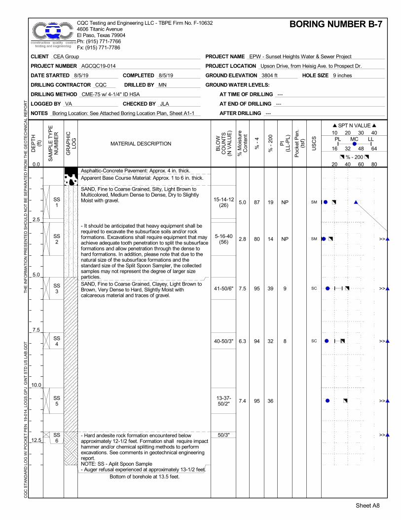
SS1
SS2
SS3
SS4
SS5
SS6
19
14
39
32
36
NP
NP
9
8
87
80
95
94
95
5.0
2.8
7.5
6.3
7.4
15-14-12(26)
5-16-40(56)
41-50/6"
40-50/3"
13-37-50/2"
50/3"
SM
SM
SC
SC
Asphaltic-Concrete Pavement: Approx. 4 in. thick.Apparent Base Course Material: Approx. 1 to 6 in. thick.
SAND, Fine to Coarse Grained, Silty, Light Brown toMulticolored, Medium Dense to Dense, Dry to SlightlyMoist with gravel.
- It should be anticipated that heavy equipment shall berequired to excavate the subsurface soils and/or rockformations. Excavations shall require equipment that mayachieve adequate tooth penetration to split the subsurfaceformations and allow penetration through the dense tohard formations. In addition, please note that due to thenatural size of the subsurface formations and thestandard size of the Split Spoon Sampler, the collectedsamples may not represent the degree of larger sizeparticles.SAND, Fine to Coarse Grained, Clayey, Light Brown toBrown, Very Dense to Hard, Slightly Moist withcalcareous material and traces of gravel.
- Hard andesite rock formation encountered belowapproximately 12-1/2 feet. Formation shall require impacthammer and/or chemical splitting methods to performexcavations. See comments in geotechnical engineeringreport.NOTE: SS - Aplit Spoon Sample- Auger refusal experienced at approximately 13-1/2 feet.
Bottom of borehole at 13.5 feet.
NOTES Boring Location: See Attached Boring Location Plan, Sheet A1-1
LOGGED BY VA
DRILLING METHOD CME-75 w/ 4-1/4" ID HSA
GROUND WATER LEVELS:
CHECKED BY JLA
DATE STARTED 8/5/19
AT TIME OF DRILLING ---
AT END OF DRILLING ---
AFTER DRILLING ---
HOLE SIZE 9 inchesGROUND ELEVATION 3804 ft
DRILLING CONTRACTOR CQC
COMPLETED 8/5/19
DRILLED BY MN
DE
PT
H(f
t)
0.0
2.5
5.0
7.5
10.0
12.5
GR
AP
HIC
LOG
SA
MP
LE T
YP
EN
UM
BE
R
% -
200
PI
(LL-
PL)
Sheet A8
% -
4
% M
oist
ure
Con
tent
BLO
WC
OU
NT
S(N
VA
LUE
)
US
CS
% - 200 20 40 60 80
16 32 48 64
PL LLMC
SPT N VALUE 10 20 30 40
Poc
ket P
en.
(tsf
)
MATERIAL DESCRIPTION
BORING NUMBER B-7
CLIENT CEA Group
PROJECT NUMBER AGCQC19-014
PROJECT NAME EPW - Sunset Heights Water & Sewer Project
PROJECT LOCATION Upson Drive, from Heisig Ave. to Prospect Dr.
CQ
C S
TA
ND
AR
D L
OG
W/ P
OC
KE
T P
EN
19-
014_
LOG
S.G
PJ
GIN
T S
TD
US
LA
B.G
DT
T
HE
INF
OR
MA
TIO
N P
RE
SE
NT
ED
SH
OU
LD N
OT
BE
SE
PA
RA
TE
D F
RO
M T
HE
GE
OT
EC
HN
ICA
L R
EP
OR
TCQC Testing and Engineering LLC - TBPE Firm No. F-106324606 Titanic AvenueEl Paso, Texas 79904Ph: (915) 771-7766Fx: (915) 771-7786
>>
>>
>>
>>
>>

SS1
SS2
SS3
SS4
15
13
NP
NP
47
43
8.2
11.9
9-12-26(38)
4-13-26(39)
7-18-20(38)
50/2"
GM
GM
Asphaltic-Concrete Pavement: Approx. 3 in. thick.
Apparent Base Course Material: Approx. 5 in. thick.
GRAVEL, Fine, Subangular, Sandy, Brown, Dense toHard, Slightly Moist with cobbles and silt.- It should be anticipated that heavy equipment shall berequired to excavate the subsurface soils and/or rockformations. Excavations shall require equipment that mayachieve adequate tooth penetration to split the subsurfaceformations and allow penetration through the dense tohard formations. In addition, please note that due to thenatural size of the subsurface formations and thestandard size of the Split Spoon Sampler, the collectedsamples may not represent the degree of larger sizeparticles.
- Hard Andesite rock formation encountered atapproximately 7-1/2 feet. Formation shall require impacthammer and/or chemical splitting material to perfomexcavations. See comments in geotechnical engineeringreport.NOTE: SS - Split Spoon Sample- Auger refusal experienced at approx. 7-1/2 feet.
Bottom of borehole at 7.5 feet.
NOTES Boring Location: See Attached Boring Location Plan, Sheet A1-1
LOGGED BY VA
DRILLING METHOD CME-75 w/ 4-1/4" ID HSA
GROUND WATER LEVELS:
CHECKED BY JLA
DATE STARTED 8/6/19
AT TIME OF DRILLING ---
AT END OF DRILLING ---
AFTER DRILLING ---
HOLE SIZE 9 inchesGROUND ELEVATION 3789 ft
DRILLING CONTRACTOR CQC
COMPLETED 8/6/19
DRILLED BY MN
DE
PT
H(f
t)
0.0
2.5
5.0
7.5
GR
AP
HIC
LOG
SA
MP
LE T
YP
EN
UM
BE
R
% -
200
PI
(LL-
PL)
Sheet A9
% -
4
% M
oist
ure
Con
tent
BLO
WC
OU
NT
S(N
VA
LUE
)
US
CS
% - 200 20 40 60 80
16 32 48 64
PL LLMC
SPT N VALUE 10 20 30 40
Poc
ket P
en.
(tsf
)
MATERIAL DESCRIPTION
BORING NUMBER B-8
CLIENT CEA Group
PROJECT NUMBER AGCQC19-014
PROJECT NAME EPW - Sunset Heights Water & Sewer Project
PROJECT LOCATION Upson Drive, from Heisig Ave. to Prospect Dr.
CQ
C S
TA
ND
AR
D L
OG
W/ P
OC
KE
T P
EN
19-
014_
LOG
S.G
PJ
GIN
T S
TD
US
LA
B.G
DT
T
HE
INF
OR
MA
TIO
N P
RE
SE
NT
ED
SH
OU
LD N
OT
BE
SE
PA
RA
TE
D F
RO
M T
HE
GE
OT
EC
HN
ICA
L R
EP
OR
TCQC Testing and Engineering LLC - TBPE Firm No. F-106324606 Titanic AvenueEl Paso, Texas 79904Ph: (915) 771-7766Fx: (915) 771-7786
>>
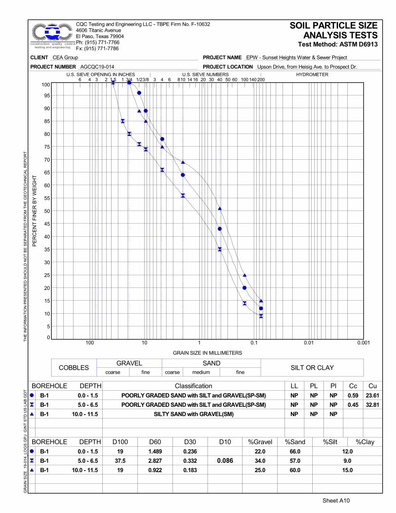
0
5
10
15
20
25
30
35
40
45
50
55
60
65
70
75
80
85
90
95
100
0.0010.010.1110100
0.59
0.45
23.61
32.81
SAND
1403 4 20 406 60
%Silt %Clay
0.086
3 100
12.0
9.0
15.0
22.0
34.0
25.0
0.236
0.332
0.183
1.489
2.827
0.922
PI Cc CuLL PL
COBBLESGRAVEL
NP
NP
NP
NP
NP
NP
24 16 301 2006 101.5 8 143/4 3/8
PE
RC
EN
T F
INE
R B
Y W
EIG
HT
SOIL PARTICLE SIZEANALYSIS TESTS
Test Method: ASTM D6913
BOREHOLE DEPTH
POORLY GRADED SAND with SILT and GRAVEL(SP-SM)
POORLY GRADED SAND with SILT and GRAVEL(SP-SM)
SILTY SAND with GRAVEL(SM)
66.0
57.0
60.0
B-1
B-1
B-1
GRAIN SIZE IN MILLIMETERS
coarse fine
Classification
D100 D60 D30 D10 %Gravel
coarseSILT OR CLAY
finemedium
%Sand
501/2HYDROMETERU.S. SIEVE OPENING IN INCHES U.S. SIEVE NUMBERS
BOREHOLE DEPTH
0.0 - 1.5
5.0 - 6.5
10.0 - 11.5
NP
NP
NP
19
37.5
19
0.0 - 1.5
5.0 - 6.5
10.0 - 11.5
B-1
B-1
B-1
CLIENT CEA Group
PROJECT NUMBER AGCQC19-014
PROJECT NAME EPW - Sunset Heights Water & Sewer Project
PROJECT LOCATION Upson Drive, from Heisig Ave. to Prospect Dr.
GR
AIN
SIZ
E 1
9-01
4_LO
GS
.GP
J G
INT
ST
D U
S L
AB
.GD
T
TH
E IN
FO
RM
AT
ION
PR
ES
EN
TE
D S
HO
ULD
NO
T B
E S
EP
AR
AT
ED
FR
OM
TH
E G
EO
TE
CH
NIC
AL
RE
PO
RT
CQC Testing and Engineering LLC - TBPE Firm No. F-106324606 Titanic AvenueEl Paso, Texas 79904Ph: (915) 771-7766Fx: (915) 771-7786
Sheet A10

0
5
10
15
20
25
30
35
40
45
50
55
60
65
70
75
80
85
90
95
100
0.0010.010.1110100
0.46 49.55
SAND
1403 4 20 406 60
%Silt %Clay
0.089
3 100
9.0
29.0
23.0
39.0
1.0
10.0
0.425
0.077
0.102
4.42
0.163
0.337
PI Cc CuLL PL
COBBLESGRAVEL
NP
NP
NP
NP
NP
NP
24 16 301 2006 101.5 8 143/4 3/8
PE
RC
EN
T F
INE
R B
Y W
EIG
HT
SOIL PARTICLE SIZEANALYSIS TESTS
Test Method: ASTM D6913
BOREHOLE DEPTH
POORLY GRADED SAND with SILT and GRAVEL(SP-SM)
SILTY SAND(SM)
SILTY SAND(SM)
52.0
70.0
67.0
B-2
B-2
B-2
GRAIN SIZE IN MILLIMETERS
coarse fine
Classification
D100 D60 D30 D10 %Gravel
coarseSILT OR CLAY
finemedium
%Sand
501/2HYDROMETERU.S. SIEVE OPENING IN INCHES U.S. SIEVE NUMBERS
BOREHOLE DEPTH
2.5 - 4.0
7.5 - 9.0
10.0 - 11.5
NP
NP
NP
25
9.5
19
2.5 - 4.0
7.5 - 9.0
10.0 - 11.5
B-2
B-2
B-2
CLIENT CEA Group
PROJECT NUMBER AGCQC19-014
PROJECT NAME EPW - Sunset Heights Water & Sewer Project
PROJECT LOCATION Upson Drive, from Heisig Ave. to Prospect Dr.
GR
AIN
SIZ
E 1
9-01
4_LO
GS
.GP
J G
INT
ST
D U
S L
AB
.GD
T
TH
E IN
FO
RM
AT
ION
PR
ES
EN
TE
D S
HO
ULD
NO
T B
E S
EP
AR
AT
ED
FR
OM
TH
E G
EO
TE
CH
NIC
AL
RE
PO
RT
CQC Testing and Engineering LLC - TBPE Firm No. F-106324606 Titanic AvenueEl Paso, Texas 79904Ph: (915) 771-7766Fx: (915) 771-7786
Sheet A11

0
5
10
15
20
25
30
35
40
45
50
55
60
65
70
75
80
85
90
95
100
0.0010.010.1110100
SAND
1403 4 20 406 60
%Silt %Clay
3 100
17.0
29.0
19.0
16.0
27.0
38.0
0.167
0.079
0.268
0.6
0.402
4.158
PI Cc CuLL PL
COBBLESGRAVEL
NP
NP
NP
NP
NP
NP
24 16 301 2006 101.5 8 143/4 3/8
PE
RC
EN
T F
INE
R B
Y W
EIG
HT
SOIL PARTICLE SIZEANALYSIS TESTS
Test Method: ASTM D6913
BOREHOLE DEPTH
SILTY SAND with GRAVEL(SM)
SILTY SAND with GRAVEL(SM)
SILTY SAND with GRAVEL(SM)
67.0
44.0
43.0
B-3
B-3
B-3
GRAIN SIZE IN MILLIMETERS
coarse fine
Classification
D100 D60 D30 D10 %Gravel
coarseSILT OR CLAY
finemedium
%Sand
501/2HYDROMETERU.S. SIEVE OPENING IN INCHES U.S. SIEVE NUMBERS
BOREHOLE DEPTH
0.0 - 1.5
7.5 - 9.0
10.0 - 11.5
NP
NP
NP
19
37.5
19
0.0 - 1.5
7.5 - 9.0
10.0 - 11.5
B-3
B-3
B-3
CLIENT CEA Group
PROJECT NUMBER AGCQC19-014
PROJECT NAME EPW - Sunset Heights Water & Sewer Project
PROJECT LOCATION Upson Drive, from Heisig Ave. to Prospect Dr.
GR
AIN
SIZ
E 1
9-01
4_LO
GS
.GP
J G
INT
ST
D U
S L
AB
.GD
T
TH
E IN
FO
RM
AT
ION
PR
ES
EN
TE
D S
HO
ULD
NO
T B
E S
EP
AR
AT
ED
FR
OM
TH
E G
EO
TE
CH
NIC
AL
RE
PO
RT
CQC Testing and Engineering LLC - TBPE Firm No. F-106324606 Titanic AvenueEl Paso, Texas 79904Ph: (915) 771-7766Fx: (915) 771-7786
Sheet A12

0
5
10
15
20
25
30
35
40
45
50
55
60
65
70
75
80
85
90
95
100
0.0010.010.1110100
2.44 183.82
SAND
1403 4 20 406 60
%Silt %Clay
0.094
3 100
32.0
9.0
22.0
21.0
62.0
31.0
2
0.164
0.922
17.369
2.483
PI Cc CuLL PL
COBBLESGRAVEL
15
NP
15
16
NP
14
24 16 301 2006 101.5 8 143/4 3/8
PE
RC
EN
T F
INE
R B
Y W
EIG
HT
SOIL PARTICLE SIZEANALYSIS TESTS
Test Method: ASTM D6913
BOREHOLE DEPTH
CLAYEY SAND with GRAVEL(SC)
WELL-GRADED GRAVEL with SILT and SAND(GW-GM)
CLAYEY SAND with GRAVEL(SC)
47.0
29.0
47.0
B-4
B-4
B-4
GRAIN SIZE IN MILLIMETERS
coarse fine
Classification
D100 D60 D30 D10 %Gravel
coarseSILT OR CLAY
finemedium
%Sand
501/2HYDROMETERU.S. SIEVE OPENING IN INCHES U.S. SIEVE NUMBERS
BOREHOLE DEPTH
0.0 - 0.2
2.5 - 2.7
7.5 - 7.7
31
NP
29
19
25
25
0.0 - 0.2
2.5 - 2.7
7.5 - 7.7
B-4
B-4
B-4
CLIENT CEA Group
PROJECT NUMBER AGCQC19-014
PROJECT NAME EPW - Sunset Heights Water & Sewer Project
PROJECT LOCATION Upson Drive, from Heisig Ave. to Prospect Dr.
GR
AIN
SIZ
E 1
9-01
4_LO
GS
.GP
J G
INT
ST
D U
S L
AB
.GD
T
TH
E IN
FO
RM
AT
ION
PR
ES
EN
TE
D S
HO
ULD
NO
T B
E S
EP
AR
AT
ED
FR
OM
TH
E G
EO
TE
CH
NIC
AL
RE
PO
RT
CQC Testing and Engineering LLC - TBPE Firm No. F-106324606 Titanic AvenueEl Paso, Texas 79904Ph: (915) 771-7766Fx: (915) 771-7786
Sheet A13

0
5
10
15
20
25
30
35
40
45
50
55
60
65
70
75
80
85
90
95
100
0.0010.010.1110100
SAND
1403 4 20 406 60
%Silt %Clay
3 100
42.0
15.0
16.0
22.0
15.0
42.0
30.0
8.0
0.536
0.337
0.139
0.55
5.456
2.766
0.67
PI Cc CuLL PL
COBBLESGRAVEL
NP
23
NP
36
24 16 301 2006 101.5 8 143/4 3/8
PE
RC
EN
T F
INE
R B
Y W
EIG
HT
SOIL PARTICLE SIZEANALYSIS TESTS
Test Method: ASTM D6913
BOREHOLE DEPTH
SILTY SAND with GRAVEL(SM)
CLAYEY SAND(SC)
43.0
43.0
54.0
70.0
B-5
B-5
B-5
B-5
GRAIN SIZE IN MILLIMETERS
coarse fine
Classification
D100 D60 D30 D10 %Gravel
coarseSILT OR CLAY
finemedium
%Sand
501/2HYDROMETERU.S. SIEVE OPENING IN INCHES U.S. SIEVE NUMBERS
BOREHOLE DEPTH
0.0 - 1.5
2.5 - 4.0
5.0 - 6.5
13.5 - 15.0
NP
59
25
25
25
19
0.0 - 1.5
2.5 - 4.0
5.0 - 6.5
13.5 - 15.0
B-5
B-5
B-5
B-5
CLIENT CEA Group
PROJECT NUMBER AGCQC19-014
PROJECT NAME EPW - Sunset Heights Water & Sewer Project
PROJECT LOCATION Upson Drive, from Heisig Ave. to Prospect Dr.
GR
AIN
SIZ
E 1
9-01
4_LO
GS
.GP
J G
INT
ST
D U
S L
AB
.GD
T
TH
E IN
FO
RM
AT
ION
PR
ES
EN
TE
D S
HO
ULD
NO
T B
E S
EP
AR
AT
ED
FR
OM
TH
E G
EO
TE
CH
NIC
AL
RE
PO
RT
CQC Testing and Engineering LLC - TBPE Firm No. F-106324606 Titanic AvenueEl Paso, Texas 79904Ph: (915) 771-7766Fx: (915) 771-7786
Sheet A14

0
5
10
15
20
25
30
35
40
45
50
55
60
65
70
75
80
85
90
95
100
0.0010.010.1110100
SAND
1403 4 20 406 60
%Silt %Clay
3 100
20.0
14.0
22.0
16.0
12.0
9.0
0.134
0.218
0.104
0.81
1.139
0.781
PI Cc CuLL PL
COBBLESGRAVEL
18
NP
20
9
NP
13
24 16 301 2006 101.5 8 143/4 3/8
PE
RC
EN
T F
INE
R B
Y W
EIG
HT
SOIL PARTICLE SIZEANALYSIS TESTS
Test Method: ASTM D6913
BOREHOLE DEPTH
CLAYEY SAND with GRAVEL(SC)
SILTY SAND(SM)
CLAYEY SAND(SC)
64.0
74.0
69.0
B-6
B-6
B-6
GRAIN SIZE IN MILLIMETERS
coarse fine
Classification
D100 D60 D30 D10 %Gravel
coarseSILT OR CLAY
finemedium
%Sand
501/2HYDROMETERU.S. SIEVE OPENING IN INCHES U.S. SIEVE NUMBERS
BOREHOLE DEPTH
0.0 - 1.5
5.0 - 6.5
13.5 - 15.0
27
NP
33
19
25
19
0.0 - 1.5
5.0 - 6.5
13.5 - 15.0
B-6
B-6
B-6
CLIENT CEA Group
PROJECT NUMBER AGCQC19-014
PROJECT NAME EPW - Sunset Heights Water & Sewer Project
PROJECT LOCATION Upson Drive, from Heisig Ave. to Prospect Dr.
GR
AIN
SIZ
E 1
9-01
4_LO
GS
.GP
J G
INT
ST
D U
S L
AB
.GD
T
TH
E IN
FO
RM
AT
ION
PR
ES
EN
TE
D S
HO
ULD
NO
T B
E S
EP
AR
AT
ED
FR
OM
TH
E G
EO
TE
CH
NIC
AL
RE
PO
RT
CQC Testing and Engineering LLC - TBPE Firm No. F-106324606 Titanic AvenueEl Paso, Texas 79904Ph: (915) 771-7766Fx: (915) 771-7786
Sheet A15

0
5
10
15
20
25
30
35
40
45
50
55
60
65
70
75
80
85
90
95
100
0.0010.010.1110100
BOREHOLE DEPTH Classification PL PI Cc Cu
25
24
9
8
19.0
14.0
39.0
32.0
36.0
GRAVEL SANDSILT OR CLAY
1403 4 20 406 603 10024 16 30
%Clay0.17
0.195
0.662
0.425
0.572
0.579
0.512
19
25
9.5
19
12.5
1 2006 101.5 8 143/4 3/8
PE
RC
EN
T F
INE
R B
Y W
EIG
HT
SOIL PARTICLE SIZEANALYSIS TESTS
Test Method: ASTM D6913
B-7
B-7
B-7
B-7
B-7
GRAIN SIZE IN MILLIMETERS
LL
16
16
D60 D30 D10 %Gravel %Sand13.0
8.0
5.0
6.0
5.0
fine coarse
501/2HYDROMETERU.S. SIEVE OPENING IN INCHES U.S. SIEVE NUMBERS
B-7
B-7
B-7
B-7
B-7
CLAYEY SAND(SC)
CLAYEY SAND(SC)
0.8 - 2.0
2.5 - 3.7
5.0 - 6.2
7.5 - 8.7
10.0 - 11.2
BOREHOLE DEPTH D100 %Silt68.0
66.0
56.0
62.0
59.0
0.8 - 2.0
2.5 - 3.7
5.0 - 6.2
7.5 - 8.7
10.0 - 11.2
COBBLEScoarse medium fine
CLIENT CEA Group
PROJECT NUMBER AGCQC19-014
PROJECT NAME EPW - Sunset Heights Water & Sewer Project
PROJECT LOCATION Upson Drive, from Heisig Ave. to Prospect Dr.
GR
AIN
SIZ
E 1
9-01
4_LO
GS
.GP
J G
INT
ST
D U
S L
AB
.GD
T
TH
E IN
FO
RM
AT
ION
PR
ES
EN
TE
D S
HO
ULD
NO
T B
E S
EP
AR
AT
ED
FR
OM
TH
E G
EO
TE
CH
NIC
AL
RE
PO
RT
CQC Testing and Engineering LLC - TBPE Firm No. F-106324606 Titanic AvenueEl Paso, Texas 79904Ph: (915) 771-7766Fx: (915) 771-7786
Sheet A16

0
5
10
15
20
25
30
35
40
45
50
55
60
65
70
75
80
85
90
95
100
0.0010.010.1110100
BOREHOLE DEPTH Classification PL PI Cc CuNP
NP
NP
NP
15.0
13.0
GRAVEL SANDSILT OR CLAY
1403 4 20 406 603 10024 16 30
%Clay0.3
0.6
10.897
13.977
25
25
1 2006 101.5 8 143/4 3/8
PE
RC
EN
T F
INE
R B
Y W
EIG
HT
SOIL PARTICLE SIZEANALYSIS TESTS
Test Method: ASTM D6913
B-8
B-8
GRAIN SIZE IN MILLIMETERS
LLNP
NP
D60 D30 D10 %Gravel %Sand53.0
38.0
fine coarse
501/2HYDROMETERU.S. SIEVE OPENING IN INCHES U.S. SIEVE NUMBERS
B-8
B-8
SILTY GRAVEL with SAND(GM)
SILTY GRAVEL with SAND(GM)
2.5 - 4.0
5.0 - 6.5
BOREHOLE DEPTH D100 %Silt32.0
30.0
2.5 - 4.0
5.0 - 6.5
COBBLEScoarse medium fine
CLIENT CEA Group
PROJECT NUMBER AGCQC19-014
PROJECT NAME EPW - Sunset Heights Water & Sewer Project
PROJECT LOCATION Upson Drive, from Heisig Ave. to Prospect Dr.
GR
AIN
SIZ
E 1
9-01
4_LO
GS
.GP
J G
INT
ST
D U
S L
AB
.GD
T
TH
E IN
FO
RM
AT
ION
PR
ES
EN
TE
D S
HO
ULD
NO
T B
E S
EP
AR
AT
ED
FR
OM
TH
E G
EO
TE
CH
NIC
AL
RE
PO
RT
CQC Testing and Engineering LLC - TBPE Firm No. F-106324606 Titanic AvenueEl Paso, Texas 79904Ph: (915) 771-7766Fx: (915) 771-7786
Sheet A17

B-1 0.0- 1.5 12 6.1 NP NP NP 78 12 SP-SM
2.5- 4.0 135.0- 6.5 8 2.7 NP NP NP 66 9 SP-SM
7.5- 9.0 1310.0- 11.5 11 4.8 NP NP NP 75 15 SM
13.5- 15.0 56B-2 0.0- 1.5 20
2.5- 4.0 50 / 4" 1.9 NP NP NP 61 9 SP-SM
5.0- 6.5 437.5- 9.0 13 6.6 NP NP NP 99 29 SM
10.0- 11.5 16 4.8 NP NP NP 90 23 SM
13.5- 15.0 50 / 6"B-3 0.0- 1.5 21 5.1 NP NP NP 84 17 SM
2.5- 4.0 75.0- 6.5 107.5- 9.0 11 7.5 NP NP NP 73 29 SM
10.0- 11.5 36 6.3 NP NP NP 62 19 SM
B-4 0.0- 1.5 20 10.2 31 15 16 79 32 SC
2.5- 4.0 20 3.0 NP NP NP 38 9 GW-GM
5.0- 6.5 87.5- 9.0 50 / 2" 5.2 29 15 14 69 22 SC
10.0- 11.5 50 / 1"B-5 0.0- 1.5 50 / 5" 7.5 NP NP NP 85 42 SM
2.5- 4.0 65 3.9 58 15
5.0- 6.5 82 3.6 70 16
7.5- 9.0 2310.0- 11.5 1613.5- 15.0 11 15.9 59 23 36 92 22 SC
B-6 0.0- 1.5 14 8.9 27 18 9 84 20 SC
2.5- 4.0 485.0- 6.5 62 5.8 NP NP NP 88 14 SM
7.5- 9.0 50 / 5"10.0- 11.5 5013.5- 15.0 45 11.8 33 20 13 91 22 SC
LiquidLimit
PlasticLimit
PlasticityIndex
WaterContent
(%)Borehole % Passing
No. 200N - Value % Passing
No. 4
SUMMARY OF LABORATORYENGINEERING SOIL CLASSIFICATION TEST
RESULTS
Depth ClassificationPocket Pen.(tsf)
TotalUnit
Weight(pcf)
CLIENT CEA Group
PROJECT NUMBER AGCQC19-014
PROJECT NAME EPW - Sunset Heights Water & Sewer Project
PROJECT LOCATION Upson Drive, from Heisig Ave. to Prospect Dr.
LAB
SU
MM
AR
Y
19-0
14_L
OG
S.G
PJ
GIN
T S
TD
US
LA
B.G
DT
T
HE
INF
OR
MA
TIO
N P
RE
SE
NT
ED
SH
OU
LD N
OT
BE
SE
PA
RA
TE
D F
RO
M T
HE
GE
OT
EC
HN
ICA
L R
EP
OR
TCQC Testing and Engineering LLC - TBPE Firm No. F-106324606 Titanic AvenueEl Paso, Texas 79904Ph: (915) 771-7766Fx: (915) 771-7786
Sheet A18

B-7 0.8- 2.3 26 5.0 87 19
2.5- 4.0 56 2.8 80 14
5.0- 6.5 50 / 6" 7.5 25 16 9 95 39 SC
7.5- 9.0 50 / 3" 6.3 24 16 8 94 32 SC
10.0- 11.5 50 / 2" 7.4 95 36
12.0- 13.5 50 / 3"B-8 0.7- 2.2 38
2.5- 4.0 39 8.2 NP NP NP 47 15 GM
5.0- 6.5 38 11.9 NP NP NP 43 13 GM
6.5- 8.0 50 / 2"
LiquidLimit
PlasticLimit
PlasticityIndex
WaterContent
(%)Borehole % Passing
No. 200N - Value % Passing
No. 4
SUMMARY OF LABORATORYENGINEERING SOIL CLASSIFICATION TEST
RESULTS
Depth ClassificationPocket Pen.(tsf)
TotalUnit
Weight(pcf)
CLIENT CEA Group
PROJECT NUMBER AGCQC19-014
PROJECT NAME EPW - Sunset Heights Water & Sewer Project
PROJECT LOCATION Upson Drive, from Heisig Ave. to Prospect Dr.
LAB
SU
MM
AR
Y 1
9-01
4_L
OG
S.G
PJ
GIN
T S
TD
US
LA
B.G
DT
TH
E IN
FO
RM
AT
ION
PR
ES
EN
TE
D S
HO
ULD
NO
T B
E S
EP
AR
AT
ED
FR
OM
TH
E G
EO
TE
CH
NIC
AL
RE
PO
RT
CQC Testing and Engineering LLC - TBPE Firm No. F-106324606 Titanic AvenueEl Paso, Texas 79904Ph: (915) 771-7766Fx: (915) 771-7786
Sheet A19

Construction Materials Testing
Geotechnical Engineering
Environmental Site Assessments
Forensic Analysis/Testing
CQC Testing and Engineering, L.L.C.
TBPE Firm Registration No. F-10632
PROJECT NO.: AGCQC19-014
PROJECT NAME: General Geotechnical Subsurface Soils Evaluation
EPW - Sunset Heights Water & Sanitary Sewer Replacement Project
El Paso, El Paso County, Texas
PROCTOR NO.: 1 SAMPLED BY: VA
SOIL SAMPLE LOCATION: SAMPLE DATE: 3/28/2019
SOIL SAMPLE APPROX. DEPTH: 1 to 3'
SOIL TYPE/DESCRIPTION:
Sieve Analysis Test Atterberg Limits Test
Test Method: ASTM D 6913 Test Method: ASTM D 4318
Sieve Size/No.Percent
Retained
Percent
PassingLimit Test
Index Test
Result
3" 0 100 LL -
2-1/2" 0 100 PL -
1-1/2" 1 99 PI NP
1" 5 95 NP-Non Plastic
3/4" 15 85 NS - Not Specified
1/2" 37 63
3/8" 42 58 Soil Classification: SP-SM
No. 4 49 51 Test Method:
No. 10 57 43
No. 40 72 28
No. 100 88 12
No. 200 92.4 7.6
NS- Not Specified
Moisture-Density Relationship TestTest Method: ASTM D 1557, Method "C"
Test Sample No.Moisture
Content (%)
Sample Dry
Density (pcf)
1 3.5 136.6
2 5.2 137.7
3 7.1 136.3
4 8.8 134.7
137.6
5.2
On Site Subsurface Soils / SAND, Fine to Coarse Grained, Gravelly, Poorly
Graded, Tannish Brown with silt
SAMPLE TEST RESULTS
SOIL MOISTURE - DENSITY RELATIONSHIP TEST RESULTS
SAMPLE INFORMATION
B-1
ASTM D 2487
Maximum Dry Density, pcf:
Optimum Moisture Content, %: 134.0
135.0
136.0
137.0
138.0
3.0 4.0 5.0 6.0 7.0 8.0 9.0
Soil
Dry
Density, pcf
Soil Moisture Content, %
Moisture - Density Curve
Sheet A20

Construction Materials Testing
Geotechnical Engineering
Environmental Site Assessments
Forensic Analysis/Testing
CQC Testing and Engineering, L.L.C.
TBPE Firm Registration No. F-10632
PROJECT NO.: AGCQC19-014
PROJECT NAME: General Geotechnical Subsurface Soils Evaluation
EPW - Sunset Heights Water & Sanitary Sewer Replacement Project
El Paso, El Paso County, Texas
PROCTOR NO.: 2 SAMPLED BY: VA
SOIL SAMPLE LOCATION: SAMPLE DATE: 3/28/2019
SOIL SAMPLE APPROX. DEPTH: 1 to 3'
SOIL TYPE/DESCRIPTION:
Sieve Analysis Test Atterberg Limits Test
Test Method: ASTM D 6913 Test Method: ASTM D 4318
Sieve Size/No.Percent
Retained
Percent
PassingLimit Test
Index Test
Result
3" 0 100 LL -
2-1/2" 0 100 PL -
1-1/2" 0 100 PI NP
1" 5 95 NP-Non Plastic
3/4" 9 91 NS - Not Specified
1/2" 13 87
3/8" 15 85 Soil Classification: SM
No. 4 18 82 Test Method:
No. 10 22 78
No. 40 31 69
No. 100 60 40
No. 200 71.4 28.6
NS- Not Specified
Moisture-Density Relationship TestTest Method: ASTM D 1557, Method "C"
Test Sample No.Moisture
Content (%)
Sample Dry
Density (pcf)
1 4.9 124.9
2 6.4 131.2
3 8.4 129.5
4 10.3 124.2
137.6
5.2Optimum Moisture Content, %:
SOIL MOISTURE - DENSITY RELATIONSHIP TEST RESULTS
SAMPLE INFORMATION
B-3
On Site Subsurface Soils / SAND, Fine to Coarse Grained, Gravelly, Silty,
Brown to Grayish Brown
SAMPLE TEST RESULTS
ASTM D 2487
Maximum Dry Density, pcf:
124.0
125.0
126.0
127.0
128.0
129.0
130.0
131.0
132.0
4.0 5.0 6.0 7.0 8.0 9.0 10.0 11.0
Soil
Dry
Density, pcf
Soil Moisture Content, %
Moisture - Density Curve
Sheet A21
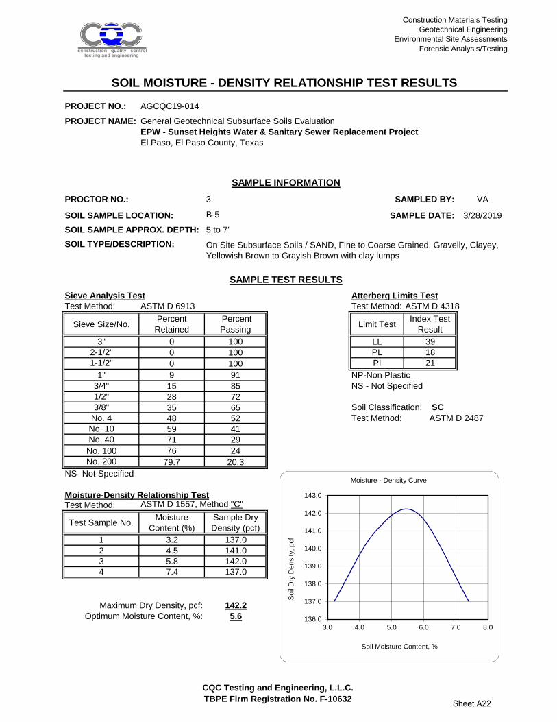
Construction Materials Testing
Geotechnical Engineering
Environmental Site Assessments
Forensic Analysis/Testing
CQC Testing and Engineering, L.L.C.
TBPE Firm Registration No. F-10632
PROJECT NO.: AGCQC19-014
PROJECT NAME: General Geotechnical Subsurface Soils Evaluation
EPW - Sunset Heights Water & Sanitary Sewer Replacement Project
El Paso, El Paso County, Texas
PROCTOR NO.: 3 SAMPLED BY: VA
SOIL SAMPLE LOCATION: SAMPLE DATE: 3/28/2019
SOIL SAMPLE APPROX. DEPTH: 5 to 7'
SOIL TYPE/DESCRIPTION:
Sieve Analysis Test Atterberg Limits Test
Test Method: ASTM D 6913 Test Method: ASTM D 4318
Sieve Size/No.Percent
Retained
Percent
PassingLimit Test
Index Test
Result
3" 0 100 LL 39
2-1/2" 0 100 PL 18
1-1/2" 0 100 PI 21
1" 9 91 NP-Non Plastic
3/4" 15 85 NS - Not Specified
1/2" 28 72
3/8" 35 65 Soil Classification: SC
No. 4 48 52 Test Method:
No. 10 59 41
No. 40 71 29
No. 100 76 24
No. 200 79.7 20.3
NS- Not Specified
Moisture-Density Relationship TestTest Method: ASTM D 1557, Method "C"
Test Sample No.Moisture
Content (%)
Sample Dry
Density (pcf)
1 3.2 137.0
2 4.5 141.0
3 5.8 142.0
4 7.4 137.0
142.2
5.6Optimum Moisture Content, %:
SOIL MOISTURE - DENSITY RELATIONSHIP TEST RESULTS
SAMPLE INFORMATION
B-5
On Site Subsurface Soils / SAND, Fine to Coarse Grained, Gravelly, Clayey,
Yellowish Brown to Grayish Brown with clay lumps
SAMPLE TEST RESULTS
ASTM D 2487
Maximum Dry Density, pcf:
136.0
137.0
138.0
139.0
140.0
141.0
142.0
143.0
3.0 4.0 5.0 6.0 7.0 8.0
Soil
Dry
Density, pcf
Soil Moisture Content, %
Moisture - Density Curve
Sheet A22

Construction Materials Testing
Geotechnical Engineering
Environmental Site Assessments
Forensic Analysis/Testing
CQC Testing and Engineering, L.L.C.
TBPE Firm Registration No. F-10632
PROJECT NO.: AGCQC19-014
PROJECT NAME: General Geotechnical Subsurface Soils Evaluation
EPW - Sunset Heights Water & Sanitary Sewer Replacement Project
El Paso, El Paso County, Texas
PROCTOR NO.: 4 SAMPLED BY: VA
SOIL SAMPLE LOCATION: SAMPLE DATE: 4/3/2019
SOIL SAMPLE APPROX. DEPTH: 1 to 5'
SOIL TYPE/DESCRIPTION:
Sieve Analysis Test Atterberg Limits Test
Test Method: ASTM D 6913 Test Method: ASTM D 4318
Sieve Size/No.Percent
Retained
Percent
PassingLimit Test
Index Test
Result
3" 0 100 LL 25
2-1/2" 0 100 PL 15
1-1/2" 0 100 PI 10
1" 0 100 NP-Non Plastic
3/4" 2 98 NS - Not Specified
1/2" 3 97
3/8" 7 93 Soil Classification: SC
No. 4 16 84 Test Method:
No. 10 25 75
No. 40 52 48
No. 100 68 32
No. 200 74.7 25.3
NS- Not Specified
Moisture-Density Relationship TestTest Method: ASTM D 1557, Method "B"
Test Sample No.Moisture
Content (%)
Sample Dry
Density (pcf)
1 3.1 126.5
2 5.2 132.6
3 6.6 134.6
4 8.6 129.6
134.7
6.5Optimum Moisture Content, %:
SOIL MOISTURE - DENSITY RELATIONSHIP TEST RESULTS
SAMPLE INFORMATION
B-6
On Site Subsurface Soils / SAND, Fine to Coarse Grained, Gravelly, Clayey,
Dark Brown to Tannish Brown
SAMPLE TEST RESULTS
ASTM D 2487
Maximum Dry Density, pcf:
125.0
126.0
127.0
128.0
129.0
130.0
131.0
132.0
133.0
134.0
135.0
3.0 4.0 5.0 6.0 7.0 8.0 9.0
Soil
Dry
Density, pcf
Soil Moisture Content, %
Moisture - Density Curve
Sheet A23

4606 Titanic Avenue
El Paso, Texas 79904
Ph. (915) 771-7766
Fx. (915) 771-7786
CQC Testing and Engineering, L.L.C.
TBPE Firm Registration No. F-10632
PROJECT NO.: AGCQC19-014
PROJECT NAME: General Geotechnical Subsurface Soils EvaluationEPW - Sunset Heights Water & Sanitary Sewer Replacement Project
El Paso, El Paso County, Texas
PROCTOR NO.: 1 SAMPLED BY: VA
SOIL SAMPLE LOCATION: SAMPLE DATE: 3/28/2019
SOIL SAMPLE DEPTH: 1 to 3'
SOIL TYPE/DESCRIPTION:
TEST SPECIMEN INFORMATION: SPECIMEN SWELL TEST INFORMATION:
Soil Sample Height, in. 4-1/2" Intial Swell Reading: 0.0740
Soil Sample Approx. Diameter, in. 6" Final Swell Reading: 0.0770
Sample Vertical Swell, % 0.0667
Soil Optimum Dry Density, pcf 137.6
Soil Optimum Moisture Content, % 5.2 Before Soaking After Soaking
Dry Density, pcf 129.9 125.1
CBR Test Data: Moisture, % 5.4 9.5
% Compaction 94.4 90.9
Stress Contact Area, in2
3.01
Sample Surcharge Load, lbs. 12.5 UNCORRECTED CALCULATED SOAKED CBR VALUES:
Soaking Period, hr's. 96
CBR @ 0.1" Penetration 63
CBR @ 0.2" Penetration 60
PEN. Load, lbs. Stress, psi
0 0 0
0.01 95 32
0.02 286 95
0.03 621 206
0.04 862 286
0.05 1144 380
0.06 1329 442
0.07 1507 501
0.08 1631 542
0.09 1756 583
0.1 1898 631
0.15 2363 785
0.2 2738 910
Stress Versus Penetration Data
SOIL CALIFORNIA BEARING RATIO (CBR) TEST RESULTSASTM D - 1883
SAMPLE INFORMATION
B-1
On Site Subsurface Soils / SAND, Fine to Coarse Grained, Gravelly, Poorly Graded,
Tannish Brown with silt
0100200300400500600700800900
0 0.05 0.1 0.15 0.2
Ca
lcu
late
d T
est S
am
ple
C
on
tact S
tre
ss, p
si
Piston Penetration, in.
CBR TestStress - Penetration Test Data
Sheet A24

4606 Titanic Avenue
El Paso, Texas 79904
Ph. (915) 771-7766
Fx. (915) 771-7786
CQC Testing and Engineering, L.L.C.
TBPE Firm Registration No. F-10632
PROJECT NO.: AGCQC19-014
PROJECT NAME: General Geotechnical Subsurface Soils EvaluationEPW - Sunset Heights Water & Sanitary Sewer Replacement Project
El Paso, El Paso County, Texas
PROCTOR NO.: 3 SAMPLED BY: VA
SOIL SAMPLE LOCATION: SAMPLE DATE: 3/28/2019
SOIL SAMPLE DEPTH: 5 to 7'
SOIL TYPE/DESCRIPTION:
TEST SPECIMEN INFORMATION: SPECIMEN SWELL TEST INFORMATION:
Soil Sample Height, in. 4-1/2" Intial Swell Reading: 0.2320
Soil Sample Approx. Diameter, in. 6" Final Swell Reading: 0.2450
Sample Vertical Swell, % 0.2889
Soil Optimum Dry Density, pcf 142.2
Soil Optimum Moisture Content, % 5.6 Before Soaking After Soaking
Dry Density, pcf 136.6 131.5
CBR Test Data: Moisture, % 5.5 9.5
% Compaction 96.1 92.5
Stress Contact Area, in2
3.01
Sample Surcharge Load, lbs. 12.5 UNCORRECTED CALCULATED SOAKED CBR VALUES:
Soaking Period, hr's. 96
CBR @ 0.1" Penetration 69
CBR @ 0.2" Penetration 84
PEN. Load, lbs. Stress, psi
0 0 0
0.01 57 19
0.02 191 63
0.03 410 136
0.04 650 216
0.05 910 302
0.06 1144 380
0.07 1373 456
0.08 1640 545
0.09 1851 615
0.1 2083 692
0.15 3105 1032
0.2 3803 1263
Stress Versus Penetration Data
SOIL CALIFORNIA BEARING RATIO (CBR) TEST RESULTSASTM D - 1883
SAMPLE INFORMATION
B-5
On Site Subsurface Soils / SAND, Fine to Coarse Grained, Gravelly, Clayey, Yellowish
Brown to Grayish Brown
0
200
400
600
800
1000
1200
0 0.05 0.1 0.15 0.2
Ca
lcu
late
d T
est S
am
ple
C
on
tact S
tre
ss, p
si
Piston Penetration, in.
CBR TestStress - Penetration Test Data
Sheet A25

3,775
3,780
3,785
3,790
3,795
3,800
3,805
3,810
3,815
0 500 1,000 1,500 2,000 2,500 3,000 3,5003,775
3,780
3,785
3,790
3,795
3,800
3,805
3,810
3,815
0 500 1,000 1,500 2,000 2,500 3,000 3,500
11-7-5(12)
3-7-6(13)
3-4-4(8)
5-5-8(13)
4-5-6(11)
17-30-26(56)
6.1
2.7
4.8
78
66
75
12
9
15
NP
NP
NP
SP-SM
SP-SM
SM
8-10-10(20)
36-47-50/4"
4-28-15(43)
10-6-7(13)
21-7-9(16)
14-10-50/6"
1.9
6.6
4.8
61
99
90
9
29
23
NP
NP
NP
SP-SM
SM
SM
10-11-10(21)
3-3-4(7)
3-3-7(10)
7-5-6(11)
5-9-27(36)
5.1
7.5
6.3
84
73
62
17
29
19
NP
NP
NP
SM
SM
SM
8-12-8(20)
18-13-7(20)
5-4-4(8)
50/2"
30-50/1"
10.2
3.0
5.2
79
38
69
32
9
22
16
NP
14
SC
GW-GM
SC
15-30-50/5"
14-26-39(65)
23-50-32(82)
20-12-11(23)
8-4-12(16)
7-4-7(11)
7.5
3.9
3.6
15.9
85
58
70
92
42
15
16
22
NP
36
SM
SC
7-7-7(14)
5-16-32(48)
22-30-32(62)
16-50/5"
9-15-35(50)
15-20-25(45)
8.9
5.8
11.8
84
88
91
20
14
22
9
NP
13
SC
SM
SC
15-14-12(26)
5-16-40(56)
41-50/6"
40-50/3"
13-37-50/2"
50/3"
5.0
2.8
7.5
6.3
7.4
87
80
95
94
95
19
14
39
32
36
NP
NP
9
8
SM
SM
SC
SC
9-12-26(38)
4-13-26(39)
7-18-20(38)50/2"
8.2
11.9
47
43
15
13
NP
NP
GM
GM
CLIENT CEA Group
PROJECT NUMBER AGCQC19-014
Ele
vatio
n (f
t)
Distance Along Baseline (ft)
SUBSURFACE PROFILE DIAGRAM
PROJECT NAME EPW - Sunset Heights Water & Sewer Project
PROJECT LOCATION Upson Drive, from Heisig Ave. to Prospect Dr.
Asphalt USCS Clayey Gravel
USCS Silty Sand Bedrock
USCS Well-graded Gravelwith Silt USCS Silty Gravel
USCS Poorly-graded Sand with Silt
USCS Clayey Sand
Base Course
ST
RA
TIG
RA
PH
Y &
GW
- B
SIZ
E 1
9-01
4_LO
GS
.GP
J G
INT
ST
D U
S L
AB
.GD
T
TH
E IN
FO
RM
AT
ION
PR
ES
EN
TE
D S
HO
ULD
NO
T B
E S
EP
AR
AT
ED
FR
OM
TH
E G
EO
TE
CH
NIC
AL
RE
PO
RT
CQC Testing and Engineering LLC - TBPE Firm No. F-106324606 Titanic AvenueEl Paso, Texas 79904Ph: (915) 771-7766Fx: (915) 771-7786
B-1N Value %MC %4 %200 PI USCS
B-2N Value %MC %4 %200 PI USCS
B-3N Value %MC %4 %200 PI USCS
B-4N Value %MC %4 %200 PI USCS
B-5N Value %MC %4 %200 PI USCS
B-6N Value %MC %4 %200 PI USCS
B-7N Value %MC %4 %200 PI USCS
B-8N Value %MC %4 %200 PI USCS
B-1
B-2
B-3
B-4
B-5B-6
B-7
B-8
SO I L S P R O F I L E A - A '
Sheet A26

Construction Materials TestingGeotechnical Engineering
Environmental Site AssessmentsForensic Analysis/Testing
APPENDIX B
“People Committed to Delivering Top-Quality Services Consistently”

Construction Materials Testing Geotechnical Engineering
Environmental Site Assessments Forensic Analysis /Testing
CQC Testing and Engineering, LLC. Sheet B1 TBPE Firm Registration No. F-10632
GEOTECHNICAL REPORT TECHNICAL REFERENCE INFORMATION
DEFINITION OF DESCRIPTIVE TERMS
DENSITY OF GRANULAR SOILS CONSISTENCY OF COHESIVE SOILS SPT N Value Relative Density SPT N Value Consistency < 4 Very Loose < 2 Very Soft 4 – 10 Loose 2 – 4 Soft 11 – 30 Med. Dense 5 – 8 Medium Stiff 31 – 50 Dense 9 – 15 Stiff 50 – 80 Very Dense 16 – 50 Very Stiff > 80 Hard > 80 Very Hard
DEGREE OF PLASTICITY
Nonplastic – Has no cohesion; will not roll into a thread. Trace of Plasticity – Barely hold its shape when rolled into a thread. Low Plasticity – Has sufficient cohesion to form a thread but will quickly rupture when deformed. Med. Plasticity – Has considerable cohesion. Can be molded into a thread and will withstand considerable deformation without rupture. High Plasticity – Can be kneaded like dough without trace of rupture.
MOISTURE DESCRIPTIONS
GRANULAR SOILS COHESIVE SOILS
Dry No Apparent Moisture No Apparent Moisture Slightly Moist < Than 3% by Weight < Less Than Plastic Limit
Moist 3% to 9% by Weight Approximately Plastic Limit Very Moist > 9% by Weight > than PL but < than LL Wet Submerged or Saturated Submerged or Saturated
PLASTICITY Cohesion Plasticity Degree of TSF Index Plasticity 0-0.125 0-5 None 0.125-0.25 5-10 Low 0.25-0.5 10-20 Moderate 0.5-1.0 20-40 Plastic 1.0-2.0 > 40 Highly Plastic > 2.0
ABBREVIATIONS
V. – Very Fl. – Fairly Sl. – Slightly Med. – Medium Tr. – Trace < - Less Than > - Greater Than PL – Plastic Limit Mod. – Moderately

Construction Materials Testing Geotechnical Engineering
Environmental Site Assessments Forensic Analysis /Testing
CQC Testing and Engineering, LLC. Sheet B2 TBPE Firm Registration No. F-10632
SOIL CLASSIFICATION CHART

Construction Materials Testing Geotechnical Engineering
Environmental Site Assessments Forensic Analysis /Testing
CQC Testing and Engineering, LLC. Sheet B3 TBPE Firm Registration No. F-10632
GEOTECHNICAL REPORT SOIL CLASSIFICATION REFERENCE INFORMATION
Cohesive Soil Classification Chart
U.S. STANDARD SIEVE 12” 3” ¾” 4 10 40 200
BOULDERS COBBLES GRAVEL SAND SILT CLAY COARSE FINE COARSE MEDIUM FINE
152 76.2 19.1 4.76 2.00 0.420 0.074 0.002
SOIL GRAIN SIZE IN MILLIMETERS
Laboratory Test Methods: Moisture Content Tests: Moisture Contents are determined from representative portions of a soil sample. The samples initial weight is recorded and it is then dried to a constant weight. From this data the moisture content is calculated. Atterberg Limit Tests: Liquid Limit (LL), Plastic Limit (PL) and Shrinkage Limit (SL) tests are performed to aid in the classification of soils and to determine the plasticity and volume change characteristics of the materials. The Liquid Limit is the minimum moisture content at which a soil will flow as a heavy viscous fluid. The Plastic Limit is the minimum moisture content at which the soil behaves as a plastic material. The Shrinkage Limit is the moisture content below which no further volume change will take place with continued drying. The Plasticity Index (PI) is the numeric difference between the Liquid Limit and the Plastic Limit and indicates the range of moisture content over which a soil remains plastic. Grain Size Distribution Test (Particle Size Analysis, Sieve Analysis): The distribution of soils finer than the No. 200 sieve is determined by passing a representative soil sample through a standard set of nested sieves. The weight of material retained on each sieve is determined and the percentage passing (or retained) is calculated. For determination of the percentage of material finer than the No. 200 sieve, the specimen is first washed through the sieve. The distribution of the materials finer than the No. 200 is determined by use of the different size particles while suspended in water.
Construction Materials Testing Geotechnical Engineering Environmental Site Assessments Forensic Analysis/Testing
APPENDIX C
“People Committed to Delivering Top-Quality Services Consistently”

Construction Materials Testing Geotechnical Engineering
Environmental Site Assessments Forensic Analysis / Testing
CLIENT: CEA Group PROJECT NAME: EPW – Sunset Heights Water & Sanitary Sewer Replacement
Program Phase 18 Project El Paso, El Paso County, Texas
Project No.: AGCQC19-014 May 21, 2019 CQC Testing and Engineering, L.L.C. Sheet C1
TBPE Firm Registration No. F-10632
PHOTO NO. 1: General view of pipeline alignment area looking south
and existing site conditions.
PHOTO NO. 2: General view of drilling activities at exploration vertical
boring B-1 location.
PHOTO NO. 3: General view of drilling activities at exploration vertical
boring B-5 location.
PHOTO NO. 4: General view of the gravelly subsurface soils formations.

“People Committed to Delivering Top-Quality Services Consistently” Local El Paso, Texas Firm