gemrams training september 23-25, 2008. south … · gemrams training september 23-25, 2008. south...
TRANSCRIPT

GEMRAMS trainingSeptember 23-25, 2008. South Florida Water Management District
Adriana Beltrán-Przekurat and Roger. A. Pielke, Sr.
Training scheduleTuesday, September 23rdMorningRAMS overview. Examples of RAMS applications. Physical and dynamic processes simulated within the model. RAMS-GEMRAMS differencesIdentification of the various input files needed for a regional simulation:
1. Topography2. Land-use/land-cover3. Soil type4. Atmospheric lateral boundary conditions.5. Sea surface temperature6. Leaf area index, vegetation fraction7. Other: soil moisture and temperature
AfternoonRAMS structure of directories. Compilation process: include.mk, compilation flags. Hands on compilation. (Exercise 1)Procedure for setting up GEMRAMS: MAKESFC, MAKEVFILE, INITIAL, HISTORY. (Exercise 2)
Description of the options in the RAMSIN namelist, physical parameters and parameterization options (microphysics, convection, radiation, land-surface models: LEAF2, GEMTM).
GEMRAMS trainingSeptember 23-25, 2008. South Florida Water Management District. Adriana Beltrán-Przekurat and Roger. A. Pielke, Sr.

RAMS training schedule
Wednesday, September 24thMorningContinuation with the RAMSIN options.Format of the output files and visualization of the results. Revu options. GEMTM variables. Grads. (Exercise 3)Continuation with the output and visualization options.Set-up the run from Marshall et al. (2004) (Exercise 4)
AfternoonHands on setting up GEMRAMS for different cases (Exercise 5): changing the surface boundary condition, downscaling global and regional atmospheric datasets and increasing CO2 concentration levels in the atmosphere
Thursday, September 25thContinuation of the hands-on exercises (Exercise 5).
GEMRAMS trainingSeptember 23-25, 2008. South Florida Water Management District. Adriana Beltrán-Przekurat and Roger. A. Pielke, Sr.

Examples of RAMS applications:• seasonal climate diagnosis,
• effects of land-use and land-cover changes on the near-surface atmosphere,
• simulations with an urban boundary-layer scheme,
• investigation of infrasound generated by tornadic storms,
• mesoscale dynamics
• development of a look-up-table (LUT) procedure
Large-scale
Short-scale
Overview of recent and ongoing work that has been conducted using RAMS within Pielke’s group.
GEMRAMS trainingSeptember 23-25, 2008. South Florida Water Management District. Adriana Beltrán-Przekurat and Roger. A. Pielke, Sr.

Investigation of the Summer Climate of North America: A Regional Atmospheric Modeling Study
Castro, CL., R.A. Pielke, Sr., and J.O. Adegoke, 2006. A Summer Climatology of the Contiguous U.S. and Mexico using the Regional Atmospheric Modeling System. J. Climate, submitted. http://blue.atmos.colostate.edu/publications/pdf/R-306.pdfCastro, C.L., R.A. Pielke, Sr., J.O. Adegoke, S.D. Schubert, and P.J. Pegion, 2006. Diagnosing the Effect of Pacific SST Associated Teleconnections Using the Regional Atmospheric Modeling System. J. Climate, submitted.http://blue.atmos.colostate.edu/publications/pdf/R-307.pdf
Percentage change in diurnal moisture flux convergence
Objective•Create a long-term summer climatology of North America using RAMS as a regional climate model (RCM) by downscaling the NCEP-NCAR Reanalysis (1950-2002).
Additional RAMS-user benefitsKain-Fritsch cumulus parameterization scheme, incorporation of NLDAS soil moisture, evaluation of value retained and added by RAMS as a
regional climate model (Castro et al. 2005).
Principal ResultsRAMS produced a reasonable summer climatology, substantially improving upon the global
reanalysis representation of the North American Monsoon.Improvement largely due to the model representation of the terrain-driven diurnal cycle of
convection and low-level moisture transport.Categorizing the simulation years by dominant modes of Pacific SST shows how large-scale
climate forcing interacts with terrain to control interannual variability in summer rainfall.
GEMRAMS trainingSeptember 23-25, 2008. South Florida Water Management District. Adriana Beltrán-Przekurat and Roger. A. Pielke, Sr.

The Influence of PreThe Influence of Pre--settlement and Current High Plains settlement and Current High Plains Land Use and Land Cover on Land Use and Land Cover on
Atmospheric, Soils, and Vegetation PropertiesAtmospheric, Soils, and Vegetation Properties
C.A. Hiemstra, R.A. Pielke Sr., T.L. Sohl1, K.L. Sayler1, T.R. Loveland1, and L.T. Steyaert1,2. 1Center for Earth Resources Observation and Science (EROS), U.S. Geological Survey, Sioux Falls, SD. 2Biospheric Sciences Branch, NASA Goddard Space Flight Center, Greenbelt, MDhttp://blue.atmos.colostate.edu/presentations/PPT-47.pdf
ObjectiveQuantify the role of High Plains land-use and land-cover change in modifying near-
surface air temperature, precipitation, soil moisture, and plant growth.
Pre-settlement Küchler’s (1964) National Land Cover Data (NLCD)

LAI 1993
GEMRAMS’ capabilities include simulation of plant growth (carbon accumulation, C3 and C4 photosynthetic pathways).Use detailed and high resolution vegetation initial conditions
LAI 2002
Satellite derived parameterizations will be incorporated into the simulations (1993 wet vs. 2002 dry
Different agriculture scenarios (i.e loss and expansion) due to different federal policy

Impact of a Dynamic Vegetation Parameterization in the NumericalSimulation of Recent Warm-Season Weather
ObjectiveInvestigate the utility of applying a dynamic vegetation parameterization in an explicitly predictive framework.
Does the added freedom (i.e. in the coupled modelling framework) for vegetation to respond to weather result in more skilful seasonal weather predictions than when vegetation phenology is prescribed (i.e. RAMS, default LAI).?
RAMSGEMRAMS (coupled RAMS+GEMTM)
Initial and lateral boundary conditions• NCEP/NCAR Reanalysis• 10 member ensemble of the NCEP Seasonal Forecast Model (SFM).
Simulation period15 May to 1 September 2000 and 2001.
Beltrán-Przekurat, A., C. Marshall, and R.A. Pielke, Sr. Accepted in JGR

Simulating changes in landSimulating changes in land--atmosphere interactions from expanding atmosphere interactions from expanding agriculture and irrigation in India and the potential impacts onagriculture and irrigation in India and the potential impacts on the Indian the Indian
Monsoon.Monsoon.
E. M. Douglas1, A. Beltrán-Przekurat, D. S. Niyogi, R.A. Pielke, Sr.. 1 Water Systems Analysis Group, University of New Hampshire
WWF Terrestrial Ecoregionsof the World.
Irrigated cropland extent from GLC2000 landcover map overlain ontothe potential landcover.
Rainfed + irrigated cropland extent from GLC2000 landcover map overlain ontothe potential landcover.
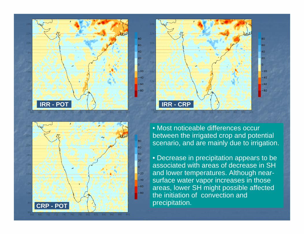
IRR - POT IRR - CRP
CRP - POT
• Most noticeable differences occur between the irrigated crop and potential scenario, and are mainly due to irrigation.
• Decrease in precipitation appears to be associated with areas of decrease in SH and lower temperatures. Although near-surface water vapor increases in those areas, lower SH might possible affected the initiation of convection and precipitation.

Using A Coupled AtmosphericUsing A Coupled Atmospheric--Biospheric Modeling System Biospheric Modeling System (GEMRAMS) to Model the Effects of Land(GEMRAMS) to Model the Effects of Land--Use/LandUse/Land--Cover Changes Cover Changes
on the Nearon the Near--Surface AtmosphereSurface Atmosphere
A. BeltrA. Beltráánn--Przekurat. Ph.D. Dissertation. Department of Atmospheric SciencePrzekurat. Ph.D. Dissertation. Department of Atmospheric Science. 2005. 2005
Increase in cropping area and changes in crop type distribution in a southern South American area
Soybean
Wheat

Land-atmosphere interactions in semiarid areas.Jornada Experimental Range.
Beltran-Przekurat, A., Pielke Sr., R.A., Peters, D.C., Snyder, K.A., Rango, A. 2008. Modeling the effects of historical vegetation change on near-surface atmosphere in the northern Chihuahuan Desert. Journal of Arid Environments. 72:1897-1910.
GEMRAMS used to assess interactions between plants, soils & atmosphere due to vegetation changes in the Jornada between 1858 (grasses) & 1998 (shrubs).

Physical and dynamical processes in RAMS are described by the basic equations
Advectionterms Sources-
sinks and subgrid-scale processes

Grid structure in RAMS
# Staggered: thermodynamic and moisture variables at the same point, but velocity components staggered
# Nested grid: allows a higher spatial resolution in selected areas of interest.
RAMS employs a two-way nesting technique: the parent grid updates the prognostic fields; values are interpolated on the boundaries of the nested grid. The nested grid takes those values an produce prognostic fields (with a smaller time step than the parent grid). When it gets to the same simulation time, then an average of the prognostic value is performed over all the grid-cells that occupy a single parent grid-cell.

Grid structure in RAMS
# Variable vertical grid spacing: stretched grid.
Resolution is higher closer to the ground; a expansion ratio is specified. An upper bound is imposed on the depth, above which the ratio is 1 (constant depth).
# Terrain-following coordinate: the bottom follows the terrain and the top of the model is flat
GEMRAMS trainingSeptember 23-25, 2008. South Florida Water Management District. Adriana Beltrán-Przekurat and Roger. A. Pielke, Sr.

Parameterization of turbulent diffusion
# Grid spacing determine the spatial scales of the prognostic variables that can be explicitly resolved and those which cannot.
# After averaging the terms in the prognostic equations, covariances/correlations terms between momentum (u,v) and scalars (temperature, water mixing ratios) appear.
# Those terms have to be represented en terms of quantities that can be resolved with the grid cell.
# RAMS parameterized the subgrid-scale fluxes using K-theory: the covariances are evaluated as the product of an eddy mixing coefficient and the gradient of the transported quantity:
Where Khi is the eddy mixing coefficient for scalars in the i-direction.
ihii x
Ku∂∂
−=φφ ''
GEMRAMS trainingSeptember 23-25, 2008. South Florida Water Management District. Adriana Beltrán-Przekurat and Roger. A. Pielke, Sr.

Parameterization of turbulent diffusion
# For velocity components, there are two different forms for the representation of the turbulence, depending on the scales of motion resolved by the model grid (horizontal vs. vertical grid spacing).
# There are currently four options for computing the mixing coefficients:
•Two local schemes: the coefficients only depend on the local and current flow properties
•Two non-local schemes: based on the local current value of turbulent kinetic energy but are regarded as non-local because kinetic energy can be generated anywhere in the simulation domain and transported.
# Values for different parameters associated with those cases have to be provided by the user and the specific case.

Other parameterizations
Precipitation processes: convection and large scale precipitation
Kuo, Kain-Fritsch schemes for convection
Single-moment scheme for cloud microphysics
Dump-bucket type of large scale parameterization
Shortwave and longwave radiation processes

ATMOSPHERE
VEGETATION
SOIL
CARBON AND WATER FLUXES
Albedo
Roughness length
Leaf area index
Canopy conductance
Root distribution
Soil texture
Temperature
Humidity
Soil and vegetation parameterizationsThe Land-Ecosystem Atmosphere Feedback model (LEAF-2) is the scheme to
represent land-surface processes within RAMS.
Temperature and water content of soil, snow cover, vegetation and canopy air are prognosed based on air temperature and humidity, and precipitation (among other variables).

CANOPY
LEAF
STEM
ROOT
REPRODUCTIVE ORGANS
LAI
CANOPY CONDUCTANCE`INTERCEPTION
EVAPORATIONWATER VAPOR
SOIL WATER
PREC
IPIT
ATI
ON
EVA
POR
ATI
ON
TRANSPIRATIONSoil water
TemperatureRelative humidityRadiation
CO2
CARBOHYDRATE POOL
PHOTOSYNTHESISC3 – C4; sunlit/shaded leaves
Temperature
DEAD MATERIAL
RES
PIR
ATI
ON
GEMRAMS

Topography
Input data for GEMRAMS
Bottom boundary conditions Initial and lateral conditions
Land-use / land-cover
Soil type
Atmospheric conditions
Sea surface temperature
Leaf area index, vegetation fraction
Soil moisture and temperature
Most of the datasets needed come with the default RAMS43 installation.
Already downloaded in GEMRAMS/ramsgeog

Boundary conditions datasets : default from www.atmet.comTopography : DEM30s
Contains the global USGS topography dataset at 10m, or about 20km resolution. Each file contains 20x20 degree blocks, with the filename denoting the southwest corner.
Vegetation classes :
This is the Olson Ecosystem dataset. This USGS dataset is based on 1-km Advanced Very High Resolution Radiometer (AVHRR) data spanning April 1992 through March 1993.
Sea surface temperature:
Monthly climatological conditions from Reynolds, 1°x1°
Soil texture :
From the Food and Agriculture Organization. Contains the global soil texture data for RAMS at 2 min, or about 4km resolution. Each file contains 5x5 degree blocks
•All of them are global•The data is in blocks, with an additional HEADER file•This data is processed “online” by RAMS through the Makesfc step

Initial and lateral boundary conditions
It can be any output of an atmospheric model that:
Has a size larger than the parent grid (2x2 deg larger)
With the variables: u and v, geopotential height, temperature and relative humidity
Defined for several pressure levels (at least 12)
With a temporal frequency of 3 – 12hs
For example: reanalysis, global forecast model
GEMRAMS trainingSeptember 23-25, 2008. South Florida Water Management District. Adriana Beltrán-Przekurat and Roger. A. Pielke, Sr.

NCEP/NCAR reanalysis
ftp.cdc.noaa.gov/Datasets/ncep.reanalysis/pressure
ECMWF reanalysis (ERA40)
http://www.ecmwf.int
NCAR: dss.ucar.edu/pub/era40
NCEP Regional Reanalysis
http://nomads.ncdc.noaa.gov/#narr_datasets
http://dss.ucar.edu/pub/narr
Forecast modelsGFS: http://fttpprd.ncep.noaa.gov/pub/data/nccf/com/pfs/prod/gfs.yyyymmddhhh/
GDAS: http://dss.ucar.edu/datasets/ds082.0/
Public domain websites for large scale reanalysis

Public domain websites for upper air and surface observations
University of WyomingGlobal, 1973 to presentUpper air
http://weather.uwyo.edu/upperair/sounding.htmlSurface observations
http://weather.uwyo.edu/surface/meteogram/
NOAA/ESRLUpper air: global, 1994 to present, online; North American archive, 1946-1997, CD-ROM
http://raob.fsl.noaa.gov/
NCAR DSSUpper air: global, 1973 to present
http://dss.ucar.edu/datasets/ds353.4/Surface: global, 1975 to present
http://dss.ucar.edu/datasets/ds464.0/

Other initial boundary conditions, like LAI, vegetation fraction and temperature and soil moistures are optional, but can have a great impact in the modeling results
In a fully-coupled mode, GEMRAMS uses only initial conditions in LAI and veg fraction. An option exists to run the model ingesting daily LAI and vegfraction datasets; this option did not exist in the original RAMS4.3.
For all those cases, the files with the datasets need to be generated “offline”, before start the model, i.e. converted to a RAMS_grid. In addition some options in RAMSIN need to be modified.
For LAI and veg fraction, they can be estimated from satellite measurements of Normalized Difference Vegetation Index (NDVI). Several dataset exist. The one we use is from GIMMS-NASA NDVI:
http://gimms.gsfc.nasa.gov/
The 8x8km dataset for North and South America is downloaded in GEMRAMS/
GEMRAMS trainingSeptember 23-25, 2008. South Florida Water Management District. Adriana Beltrán-Przekurat and Roger. A. Pielke, Sr.
Soil moisture and temperature datasets are harder to obtain to initialize the model simulations.
There are some soil moisture content data out there:
•CPC http://www.cpc.ncep.noaa.gov/soilmst/sm_glb.htmlglobal soil moisture datset from 1979-present at 1 degree resolution.
•University of Washington, one of which is a 1/8 degree dataset over North America for 1950-2000. www.hydro.washington.edu
This dataset is processes offline, and ingested in RAMS during a make init run
GEMRAMS trainingSeptember 23-25, 2008. South Florida Water Management District. Adriana Beltrán-Przekurat and Roger. A. Pielke, Sr.

Other input data (nonOther input data (non--default)default)
Other Databases that can be of interestOther Databases that can be of interest
Soil textureSoil textureSTASTGO database:STASTGO database:http://http://soils.usda.gov/survey/geography/statsgosoils.usda.gov/survey/geography/statsgo//State Soil Geographic (STATSGO) Database. The STATSGO spatial anState Soil Geographic (STATSGO) Database. The STATSGO spatial and d
tabular data were revised and updated in 2006. STATSGO has been tabular data were revised and updated in 2006. STATSGO has been renamed to the U.S. General Soil Map (STATSGO2).renamed to the U.S. General Soil Map (STATSGO2).
Land cover Land cover http://http://landcover.usgs.govlandcover.usgs.gov//From the USGS Land Cover Institute, NLCD datasetFrom the USGS Land Cover Institute, NLCD dataset
Other sites:Other sites:http://http://landcover.usgs.gov/landcoverdata.phplandcover.usgs.gov/landcoverdata.php

code:/bin/: make and include files, and model binariessrc/: source code (several subdirectories)
ramsgeog/: several subdirectories with topography, vegetation, sea surface temperature, soil texture datasets
gemtest/:ssa/: Southern South America testsfl/: South Florida set-up and test
GEMRAMS model source code and tests
GEMRAMS trainingSeptember 23-25, 2008. South Florida Water Management District. Adriana Beltrán-Przekurat and Roger. A. Pielke, Sr.

code:/bin/: make and include files, and model binaries
include.mk : compiler settings and MPI variablesMakefile : calls other Makefiles for building rams, utils, lib, ncargd, revudep_rams-4.3.0.mk : include the dependencies for each fortran file
src/: source code (several subdirectories)post/: REVU 2.3.1, RAMS outputs post-processingrams/:
model/: main model source codeisan/: main code to create the atmospheric initial and lateral
boundary conditions (Variable initialization step)lib/: library for /rams directoryinclude/: include files
utils/: utilities library

RAMS compilation steps
To build new binaries, execute within bin/ (specially if compilation flags changed or .h files were modified):
make clean_allmake ncargdmake utilsmake libmake ramsmake revu
Or make all
GEMRAMS trainingSeptember 23-25, 2008. South Florida Water Management District. Adriana Beltrán-Przekurat and Roger. A. Pielke, Sr.

The steps:
Makesfc
Makevfile and
Initial
Are the sequence to start a new modeling simulation. Parameters in RAMSIN have to be change accordingly.
GEMRAMS trainingSeptember 23-25, 2008. South Florida Water Management District. Adriana Beltrán-Przekurat and Roger. A. Pielke, Sr.

dpdp-- files formatfiles format
GEMRAMS trainingSeptember 23-25, 2008. South Florida Water Management District. Adriana Beltrán-Przekurat and Roger. A. Pielke, Sr.

LeafLeaf--2 & GEMTM arrays structure2 & GEMTM arrays structure