gascoyne joint development assessment panel agenda daps/gascoyne... · gascoyne joint development...
TRANSCRIPT

Version: 1 Page 1
Gascoyne Joint Development Assessment Panel
Agenda
Meeting Date and Time: Tuesday 12 February 2013, 11:30am Meeting Number: 2 Meeting Venue: Shire of Carnarvon Francis Street Carnarvon Attendance
DAP Members Mr Ed Turner (Presiding Member) Mr Rory O’Brien (A/Deputy Presiding Member) Cr Neil Ganzer (Local Government Member, Shire of Carnarvon) Cr Melissa Gibbings (Local Government Member, Shire of Carnarvon) Officers in attendance Mr Ron Couacaud (DoP) Mr Ian D’arcy (Shire of Carnarvon) Applicant, Submitters and Members of the Public Nil
Local Government Minute Secretary Ms Danielle Hill (Shire of Carnarvon) 1. Declaration of Opening
The Presiding Member declares the meeting open and acknowledges the past and present traditional owners and custodians of the land on which the meeting is being held.
2. Apologies
Mr David Gray (Deputy Presiding Member) Mr Kent McDowall (Specialist Member)
3. Members on Leave of Absence
Nil
4. Noting of Minutes
Note the minutes of the Gascoyne JDAP meeting No.1 held on the 26 September 2012.

Version: 1 Page 2
5. Disclosure of Interests
Member/Officer Report Item Nature of Interest
Mr David Gray Item 8.1 Direct Pecuniary Interest Mr Kent MacDowall Item 8.1 Direct Pecuniary Interest
6. Declarations of Due Consideration
Any member who is not familiar with the substance of any report or other information provided for consideration at the DAP meeting must declare that fact before the meeting considers the matter.
7. Deputations and Presentations
7.1 Mr Chris Outtersides (City Plan Strategy & Development) presenting for
the application at Item 8.1. The presentation will support the Council report but request changes to Condition 2(c) and Condition 10.
8. Form 1 - Responsible Authority Reports – DAP Application 8.1 Application Details: Proposed National Broadband Network (NBN)
Satellite Earth Station Property Location: Lot 1 on DP 47769 Mahony Avenue Brown
Range Applicant: Woods Bagot (for NBN Company) Owner: Shire of Carnarvon Responsible authority: Shire of Carnarvon Report date: 1 February 2013 DoP File No: DP/12/01278
9. Form 2 – Responsible Authority Reports - Amending or cancelling DAP development approval
Nil
10. Appeals to the State Administrative Tribunal
Nil
11. Meeting Closure

Page 1 Mr Ed Turner Presiding Member, Gascoyne JDAP
Minutes of the Gascoyne Joint Development Assessment
Panel Meeting Date and Time: Wednesday 26 September 2012, 10am Meeting Number: 1 Meeting Venue: Department of Planning Room L2.39 140 William Street Perth Attendance
DAP Members Mr Ed Turner (Presiding Member) Mr David Gray (Deputy Presiding Member) Mr Kent McDowall (Specialist Member) Cr Ross Winzer (Local Government member, Shire of Exmouth) – via teleconference Cr Turk Shales (Local Government member, Shire of Exmouth) – via teleconference Officers in attendance Ms Noelene Jennings (Department of Planning) Mr Ron Couacaud (Department of Planning) Mr Rhassel Mhaso (Shire of Exmouth) – via teleconference
Department of Planning Minute Secretary Ms Zoe Hendry Applicant/Submitter Mr Frank Iemma (Oldfield Knott Architects) Mr Gary Cossill (Sunrise Beach Resort Pty Ltd) 1. Declaration of Opening
The Presiding Member, Mr Ed Turner declared the meeting open at 10:00am on 26 September 2012 and acknowledged the past and present traditional owners and custodians of the land on which the meeting was being held.
2. Apologies Nil
3. Members on Leave of absence
Nil

Page 2 Mr Ed Turner Presiding Member, Gascoyne JDAP
4. Noting of minutes Nil
5. Disclosure of interests
Panel member, Mr David Gray, declared an Impartiality Interest in item 8.1.
In accordance with section 4.6.1 and 4.6.2 of the Standing Orders 2011, the Presiding Member of the Gascoyne JDAP agreed that the member listed above, who have disclosed an impartiality interest, is permitted to participate in discussion and voting on the items.
6. Declaration of Due Consideration Nil
7. Deputations and presentations 7.1 Mr Frank Iemma (Oldfield Knott Architects Pty Ltd, addressed the panel for
Item 8.1 and discussed Condition 6, 12, 15, 20 and Advice Note II, V, VI, and VII.
The Presiding Member requested that Mr Mhaso provide a summary of the Responsible Authority Report and the comments on the items raised in the presentation. It was noted that the application had included a proposal for use of the proposed units as holiday accommodation. Such use was an SA use under the Shire’s Scheme which required advertising prior to determination of the application. Mr Mhaso advised that the proposal had not been advertised. Moved by: Mr David Gray Seconded by: Mr Kent McDowall That the meeting be adjourned for 5 minutes. CARRIED UNANIMOUSLY. The applicant left the room at 10:27am and re-entered the room at 10:37am The Presiding Member declared the meeting re-opened at 10:38am
8. Form 1 - Responsible Authority Reports – DAP Application/s 8.1 Application Details: Proposed Construction of Eighteen Residential
Grouped Dwellings Property Location: Lot 902 Madaffari Drive, Exmouth Applicant: Oldfield Knott Architects Pty Ltd Owner: Sunrise Beach Resort Pty Responsible authority: Shire of Exmouth Report date: 20 August 2012 DoP File No: DP/12/00932
Mr Gary Cossill advised that the applicant agreed to withdraw the holiday accommodation use from the application.


Page 1
Form 1 - Responsible Authority Report (Regulation 12)
Application Details: Proposed National Broadband Network (NBN) Satellite Earth Station
Property Location: Lot 1 on DP 47769 Mahony Avenue Brown Range
DAP Name: Gascoyne JDAP
Applicant: Woods Bagot (for NBN Company)
Owner: Shire of Carnarvon
LG Reference: P88/12
Responsible Authority: Shire of Carnarvon
Authorising Officer: Ian D’Arcy – Director Development Services
Application No and File No: P88/12 and A1868
Report Date: 01 February 2013
Application Receipt Date: 15 November 2012
Application Process Days: 53 working days
Attachment(s): Attachment 1 – City Plan Services Planning Application Report – November 2012 Attachment 2 – Heritage Impact Statement by City Plan – November 2012 Attachment 3 - Site Analysis (Drawing No. CV-AR-DA-1051A) Attachment 4 - Site Plan (Drawing No. CV-AR-DA-1052A) Attachment 5 – Secure Site Plan (Drawing No. CV-AR-DA-1053A) Attachment 6 - Ground Floor Plan (Drawing No. CV-AR-DA-2250A) Attachment 7 – Roof Plan (Drawing No. CV-AR-DA-2251A) Attachment 8 – Northern and Southern Elevations (Drawing No. CV-AR-DA-3050A) Attachment 9 – Western and Eastern Elevations (Drawing No. CV-AR-DA-3051A) Attachment 10 - Sections (Drawing No. CV-AR-DA-3150A) Attachment 11 – Fences and Gate Details (Drawing No. CV-AR-DA-5450A) Attachment 12 – Notification Plan (Drawing No. CV-AR-DA-9003A) Attachment 13 – Civil Works Detailed Site Plan – SES Compound (Drawing No. CV-CW-CD1101) Attachment 14 – Civil Works Detailed Site Plan – Battle Axe Access Road (Drawing No. CV-CW-CD1102) Attachment 15 – 19m Semi-Articulated Vehicle Turnpath Plan – SES Compound (Drawing No. CV-CW-SK1001) Attachment 16 – 19m Semi-Articulated Vehicle Turnpath Plan – Battle Axe Access

Page 2
Road (Drawing No. CV-CW-SK1002) Attachment 17 – 8.8m Service Vehicle Turnpath Plan – SES Compound (Drawing No. CV-CW-SK1003) Attachment 18 - Heritage Council of WA Assessment (to be tabled) Attachment 19 - Schedule of Submissions Attachment 19a, b, c, d, e, f, g - Copy of Public Submissions Attachment 20 - Applicant’s Response to Submissions
Recommendation: That the Gascoyne JDAP resolves to Approve DAP Application reference P88/12 and accompanying plans (Attachments 3 to 17) to develop a Telecommunication Infrastructure – NBN Satellite Earth Station accordance with Clauses 4.2.5 and 2.4.3 (ii) of the Shire of Carnarvon Town Planning Scheme No.10, subject to the following conditions as follows: Conditions of Approval 1. The development shall be undertaken in accordance with the attached approved
plan(s) and subject to any modifications required as a consequence of any condition(s) of this approval. The endorsed plans shall not be modified or altered without the prior written approval of the local government CEO (or delegate).
2. Prior to the issue of a building permit the proponent shall:
a) Provide written confirmation of an agreed arrangement with the Birmingham
University, UK to accommodate the existing solar observatory and associated infrastructure, either through retention of the facility in its current location or proposed relocation to an alternative area on the OTC site.
b) Provide a Construction Management Plan for endorsement by the CEO (or delegate).
c) Provide a copy of the written response from Airservices Australia confirming the Satellite Antennas will not interfere with aircraft movements.
d) Undertake further investigation to retain or interpret the telemetry concrete pad, and provide a revised site plan that reflects the actions to be taken for endorsement by the Executive Director of the State Heritage Office and local government CEO (or delegate).
3. The proponent shall provide a photographic archival record of the equipment
shelter prior to demolition works.
4. The proponent shall be responsible for the widening of the Mahony Avenue road pavement between North West Coastal Highway and the proposed battle-axe access road to achieve a minimum 7.0 metre wide bitumen seal in accordance with Local Government’s road construction specifications.
Page 3
5. As depicted on the approved site plan (Drawing No. CV-AR-DA-1052A) the battle-axe and internal access roads, parking and service bays where defined shall be constructed to an impervious sealed, kerbed, and drained standard, and where applicable line marked, to the design standards and specifications of the local government and Australian Standard AS2890.
6. As depicted on the approved site plan (Drawing No. CV-AR-DA-1052A) the unsealed access road within the NBN compound shall be constructed to an all-weather gravel pavement with open swale drainage to the design standards and specifications of the local government.
7. The temporary access road around the existing OTC Casshorn Antenna shall be constructed to a compacted gravel standard, and upon completion of construction works, be removed with the area being reinstated to the satisfaction of the CEO (or delegate).
8. All stormwater generated from the development (including roof and or other paved/impervious areas) shall be retained on site and disposed of at the proponents expense.
9. All remnant vegetation around the external periphery of the security fence and on the side slopes to the east and northwest of the Satellite Earth Station development shall be retained to the satisfaction of the local government CEO
(or delegate).
10. The external finishes to the Satellite Earth Station development shall present in muted tones, such as off white, light grey or pale green, to blend with the existing OTC facility and surrounding environs.
11. All external lighting is to be positioned and shielded so as not to cause any direct or reflected light that may have an adverse effect on nearby properties.
Advice Notes a) This approval does not confer approval under other relevant legislation. It is the
responsibility of the Applicant to determine any necessary approvals required and obtain such approvals prior to obtaining a Building Permit.
b) With reference to Condition 2a), further consideration and consent may be required by the Shire Council should agreement be reached between NBN Co. and Birmingham University to relocate the existing solar observatory to an alternative area within the OTC site.
c) With reference to Condition 2b), the Construction Management Plan shall address as a minimum:
construction times to minimise noise in consideration of residential amenity;
mitigation measures to control dust and where practical vibration; and
provide detail on signage (safety and security) and location of site office; amenity buildings, material laydown/storage area, and machinery parking area onsite.
Page 4
d) With reference to Condition 2c), the applicant is advised the satellite antennas/dishes may need to incorporate safety navigation beacons, as required by aviation regulations. In this regard contact should be made with Airservices Australia.
e) With reference to Condition 3 the archival record is to include a scaled site plan and be prepared according to the WA Heritage Council’s ‘Guide to Preparing an Archival Record’.
f) With reference to Condition 8, the approach to stormwater management is to accord with the requirements of local government and the current Australian Rainfall and Run-off Manual to ensure the overflow from soak wells and other site drainage measures does not adversely discharge onto or through adjoining properties. Details on the site specific design to control and disposal of stormwater from the site are to be submitted with the preparation of a building application.
g) With reference to Condition 9, the retention of remnant vegetation does not negate statutory requirements as prescribed under the Bushfire Act, 1954 and subsidiary legislation.
h) The applicant is advised that development approval is valid for a period of two (2) years from the date of determination. If the development is not completed within this time the development approval will lapse.
i) Should the applicant be aggrieved by this determination there is a right under the provisions of the Planning and Development Act 2005 to have the decision reviewed by the State Administration Tribunal with 28 days from the decision.
Background:
Property Address: Lot 1 Mahony Avenue Brown Range
Zoning TPS No.10: Residential R10 and Special Use - OTC
Use Class: Telecommunications – Not Listed in Table 1 of Town Planning Scheme No.10
Strategy Policy: Ningaloo Coast Regional Strategy
Development Scheme: Not Applicable
Lot Size: 48,581m2
Existing Land Use: Satellite Earth Station – Overseas Telecommunications – Heritage Listed
Value of Development: $12 million
As part of the role out of the National Broadband Network (NBN) a proposed Satellite Earth Station facility is required to be established in Carnarvon. Through a thorough site investigation and a number of discussions with Shire staff NBN Co. (the proponent) expressed an interest in securing approximately 10,000m2 of land that constitutes the northern portion of the existing Overseas Telecommunications (OTC) site on Brown Range owned by the Shire. The subject area also accommodates a small radio observatory telescope owned and operated by the Birmingham University, England.
Page 5
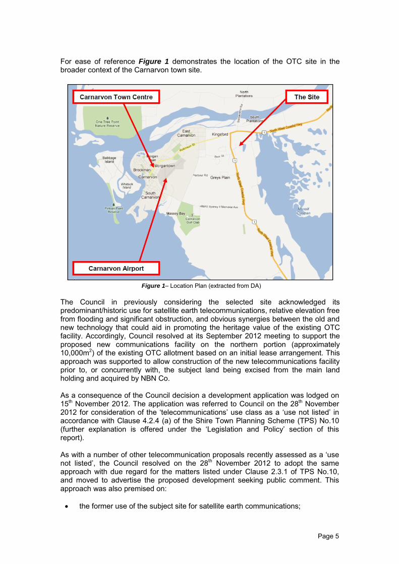
For ease of reference Figure 1 demonstrates the location of the OTC site in the broader context of the Carnarvon town site.
Figure 1– Location Plan (extracted from DA)
The Council in previously considering the selected site acknowledged its predominant/historic use for satellite earth telecommunications, relative elevation free from flooding and significant obstruction, and obvious synergies between the old and new technology that could aid in promoting the heritage value of the existing OTC facility. Accordingly, Council resolved at its September 2012 meeting to support the proposed new communications facility on the northern portion (approximately 10,000m2) of the existing OTC allotment based on an initial lease arrangement. This approach was supported to allow construction of the new telecommunications facility prior to, or concurrently with, the subject land being excised from the main land holding and acquired by NBN Co. As a consequence of the Council decision a development application was lodged on 15th November 2012. The application was referred to Council on the 28th November 2012 for consideration of the ‘telecommunications’ use class as a ‘use not listed’ in accordance with Clause 4.2.4 (a) of the Shire Town Planning Scheme (TPS) No.10 (further explanation is offered under the ‘Legislation and Policy’ section of this report). As with a number of other telecommunication proposals recently assessed as a ‘use not listed’, the Council resolved on the 28th November 2012 to adopt the same approach with due regard for the matters listed under Clause 2.3.1 of TPS No.10, and moved to advertise the proposed development seeking public comment. This approach was also premised on:
the former use of the subject site for satellite earth communications;

Page 6
the compatibility in physical form, character and fabric with the existing OTC facility;
the elevation of the selected site being free of significant flood events and relatively unobscured from other structures to achieve uninhibited satellite reception and transmission;
the proposed use/development is unlikely to conflict with any existing or future surrounding land use or development, including the approved residential subdivision over Lot 9500 that adjoins to the east.
The development application was subsequently advertised seeking public comment in line with the ‘SA’ procedures under Clause 4.3.3 of TPS No.10. The application and accompanying Heritage Impact Statement was also referred to the WA Heritage Council for assessment. Details: outline of development application The proposed NBN Satellite Earth Station (SES) facility will form part of the wider NBN Network that is currently being ‘rolled out’ across Australia. Part of the wider network is satellite telecommunications to services regional and remote areas (including Christmas, Cocos, Norfolk and Macquarie Islands) unable to be connected to the NBN fibre optic or wireless services. The application details the proposed development will involve the following works:
Demolition / removal of the existing equipment shelter, telemetry antenna support and slab, existing access road and "telescope" structure as annotated on the plans;
Construction of a sealed access road from Mahony Avenue, to provide vehicular access to the proposed facility;
Construction of internal sealed and unsealed roads around the perimeter of the facility, as outlined in the civil plans accompanying this application;
Installation of two (2) antenna array in the north-eastern part of the site with a maximum height of 15.77 metres;
Construction of a main building at the centre of the facility, which will consist of a vestibule, technical rooms, a store room, office room, staff lunch room and amenities (toilets and shower). The main building will have a sloping roof to a maximum height of 6.45 metres;
To the north-east and south-east of the main building will be sealed pedestrian pathways;
To the south-west and south-east of the main building will be at-grade sealed car parking areas with ten (10) car parking spaces. One (1) of these spaces will be accessible and four (4) will be sited under a covered carport. To the south-west of the carport will be an enclosed garage;
To the south of the main building are two (2) rainwater tanks of a capacity of 25,000 litres each, one (1) generator and a fuel tank (10,000 litre capacity) and pump enclosure, which will fuel the generators, mainly, for the purpose of isolating mains during storms or other events that could result in poor utility supply;
To the north-west of the main building is an "open" / un-roofed air conditioner zone which will serve the main building;
A three (3) metre high security fence is proposed around the perimeter of the facility. This fence will consist of chain mesh electrified cable wires with four

Page 7
(4) strands of barbed wire above. This fencing is required to ensure that the facility, which is critical telecommunications infrastructure, is secure; and
An on-site sewerage system is required to be installed and constructed for the proposed development. This will consist of a septic tank and standard absorption trench, to be designed and installed in accordance with Council's requirements.
The above outline is supported by Figure 2 and Figure 3, also extracted from the development application, illustrating the location and indicative site layout of the proposed NBN Satellite Earth Station facility. Figure 4 provides a further graphical understanding of the proposed facility by way of a north-west and south-east elevation of the proposed building structures.
Figure 2– Site Plan (extracted from DA)

Page 8
Figure 3 – Othophoto – Indicative NBN Communications Facility Site Layout (extracted from DA)
Figure 4 – Conceptual Elevation of the NBN Communications Facility (extracted from DA)

Page 9
The application also details the proposed SES development:
will operate 24 hours a day, 7 days a week;
will accommodate 2 staff members on an occasional basis, with additional staffing required during periods of upgrade and maintenance activities;
generally accords with statutory and strategic framework, including Commonwealth legislation; State legislation and policy; and local planning instruments;
notwithstanding base ‘Residential’ zoning, is appropriately sited in consideration of the surrounding context afforded by the former OTC facility, will provide a level of visual interest within the existing landscape setting, and represents an orderly and economic use of the land;
will not adversely impact on the surround land uses or result in any adverse impact on any views;
will result in a high level of external appearance and presentation. With reference to the Heritage Impact Statement (HIS) the analysis undertaken by the applicant concludes in part that “the proposed works involving the construction of a new antenna array and associated building within the curtilage of the OTC Earth Satellite Station (fmr), will not have any adverse impact on the overall heritage significance of the OTC Station.” A copy of the complete development application, including plans and heritage impact statement, is included as Attachments to this report. Legislation & policy: Legislation Commonwealth Telecommunication Act, 1997 and Telecommunication (Low
Impact Facilities) Determination, 1997 Planning and Development Act, 2005 and Planning and Development
(Development Assessment Panels) Regulations 2011 Heritage Act of Western Australia, 1990 Shire of Carnarvon Town Planning Scheme No.10
Policy State Planning Policy No. 3.5 – Historic Heritage Conservation State Planning Policy No. 5.2 – Telecommunications Infrastructure Ningaloo Coast Regional Strategy Carnarvon to Exmouth
Consultation: Public Consultation In accordance with clause 4.3.3 of the Shire TPS No.10 the application was advertised through the following approaches seeking public comment for a period of 29 days, commencing from Wednesday 5th December 2012 to Wednesday 2nd January 2013 inclusive:
Advertisement published twice in the Northern Guardian newspaper;
letters forwarded to surrounding and nearby landowners; and
a sign erected on-site.

Page 10
In response a total of seven (7) submissions were received, five (5) in support, one (1) indifferent, and one (1) strongly objecting to the proposal. A summary of each submission together with officer comment and recommendation is offered in a schedule of submissions included as Attachment 19 to this report, with a copy of each submission included as Attachments 19a, 19b, 19c, 19d, 19e, 19f, 19g. The applicant has also provided a response to two of the public submissions (19f and 19g), which is offered as Attachment 20. Consultation with other Agencies or Consultants The application and accompanying heritage impact statement was referred to the Heritage Council of WA in light of the OTC site being listed on the State Heritage Register. The Heritage Council has advised “that the proposed National Broadband Network Satellite Earth Station located at the OTC Satellite Earth Station (fmr), Carnarvon has been considered in the context of the identified cultural significance of the place and the following advice is given:
Findings
The proposed use is consistent with the historical associations with telecommunications that underpin the heritage significance of the place.
The appearance and scale of the proposed facility do not unduly disrupt the landscape values of the site nor do they dominate significant landmarks within the place, such as the Casshorn and parabolic antennas.
The demolition of the 1978 telemetry equipment shelter is supported.
The telemetry concrete pad is a physical remnant of a previous use and should be retained or interpreted
Advice The proposed development, in accordance with the plans submitted, is supported subject to the following conditions: 1. Further investigation shall be undertaken to retain the telemetry concrete pad.
A revised plan is to be submitted to the satisfaction of the Executive Director of the State Heritage Office.
2. A photographic archival record of the structure proposed for demolition shall
be prepared and submitted prior to demolition works. The archival record is to include a scaled site plan and be prepared according to the attached Guide to Preparing an Archival Record.
3. Landscaping appropriate to the registered place shall be implemented.”
Page 11
A copy of the Heritage Council submission is to be tabled at the JDAP as Attachment 18. Planning assessment: State Planning Policy No. 5.2 – Telecommunications Infrastructure State Planning Policy No. 5.2 (SPP 5.2) aims to facilitate the development of an effective state-wide telecommunications network in a manner consistent with the economic, environmental and social objectives of orderly and proper planning. SPP 5.2 is supplemented by ‘Guidelines for the Location, Siting and Design of Telecommunications Infrastructure’, with the following relevant principles:
Telecommunication facilities should be designed and sited to minimize any potential adverse visual impact on the character and amenity of the local environment, in particular, impacts on prominent landscape features, general views in the locality and individual significant views; and
Telecommunication facilities should be designed to minimize adverse impacts on the visual character and amenity of residential areas.
Given the application has been prepared to address guideline principals for location, siting and design, as reflected in Table 3 of the application, and to a large extent the siting and design presents a strong synergy with the existing OTC setting and fabric, it is accepted the requirements of SPP 2.5 have been satisfied. Ningaloo Coast Regional Strategy Carnarvon to Exmouth To a limited degree the application is referenced to the Carnarvon Structure Plan that falls within the Ningaloo Coast Regional Strategy (NCRS). The Structure Plan acknowledges the subject land as ‘residential’ and the OTC as a significant heritage site. Specifically, section 2.1.8 (Page 131) recognises the OTC site for conservation and tourism purposes with development of the surrounding land for low density housing at a minimum site area of 2,000m2. However, it is acknowledged the Structure Plan does not present in specific detail on future development or enhancement of the OTC site. As highlighted in the application, the Structure Plan seeks to guide land use and development, particularly in consideration of flood risk. With the OTC site being naturally elevated it is accepted the NBN SES site is sufficiently removed from the risk of flood. Shire of Carnarvon Town Planning Scheme (TPS) No.10 Development (Planning) Approval is required in accordance with Clause 2.1.1, with the Council (or JDAP) compelled to have due regard for the matters listed under Clause 2.3.1 of TPS No.10 before determining the application under Clause 2.4.2. In consideration the application Lot 1 is zoned ‘Residential R10’ and ‘Special Use - OTC’ with listing on the State Heritage Register as shown in Figure 5.

Page 12
Figure 5 – Extract Zoning Map 04 –TPS No.10
With regard to planning considerations the following assessment is offered:
Planning Consideration
Officer Comment
Permissibility
Arguably the proposed NBN telecommunications facility could fall under the definition of ‘Public Utility’ in the Shire TPS No.10, which is a permitted use in the ‘Residential’ zone. However, the proposal has been interpreted by Council as a ‘use not listed’ under Clause 4.2 – Land Use Under The Scheme. (own emphasis) The definition of ‘Public Utility’ as provided in the Scheme reads:
“Public Utility” - means any works or undertaking constructed or
maintained by a public authority or municipality as may be required to provide water, sewerage, electricity, gas, drainage, communications or other similar services.(own emphasis)
As for a ‘use not listed’ Clauses 4.2.4 and 4.2.5 of the TPS affords the Council (or JDAP) the exercise of discretionary power to determine the application once the proposal has been advertised seeking public comment in accordance with the Clause 4.3.3 of the Scheme.

This is an unlicensed copy of Split Pdf
This page will be appended to every output
in unlicensed mode only.
For purchase information see our website
http://www.traction-software.co.uk/servertools/splitpdf/
Thank you,