garmin gns 430w workshop - flying 20 club · gps and waas overview global positioning system (gps)...
TRANSCRIPT

Garmin GNS 430W Workshop
VFR & IFR Operations

Presentation Outline General GPS/WAAS Concepts
GPS/WAAS Overview
GPS Navigation Concepts
GPS vs VLOC Navigation
Basic 430W Operations GNS 430 Overview
Start-Up Screens
“Knobology”
Entering Data
Terrain Awareness
Traffic & Weather Pages
Useful Features & Tips
Scheduler / Flight Timer
Winds Aloft
Vertical Navigation
GPS Do’s and Don’ts
Garmin PC Simulator
Break
IFR Operations Are you IFR legal?
Database Updates
Flight Plans
Intercepting Airways
SIDs and STARs
Approaches
Amended Flight Plans
Intro to GPS Approaches
GPS Approach Modes
Example Flights
KDXR -> KGON (GON ILS Rwy 5)
OXC RNAV (GPS) Rwy 18
MMK GPS Rwy 36
IFR Do’s and Don’ts
Review
GPS/WAAS Overview
A Brief Review
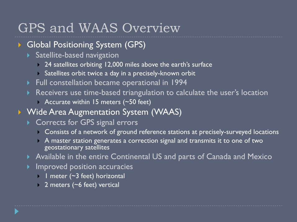
GPS and WAAS Overview Global Positioning System (GPS)
Satellite-based navigation 24 satellites orbiting 12,000 miles above the earth’s surface
Satellites orbit twice a day in a precisely-known orbit
Full constellation became operational in 1994
Receivers use time-based triangulation to calculate the user’s location Accurate within 15 meters (~50 feet)
Wide Area Augmentation System (WAAS) Corrects for GPS signal errors
Consists of a network of ground reference stations at precisely-surveyed locations
A master station generates a correction signal and transmits it to one of two geostationary satellites
Available in the entire Continental US and parts of Canada and Mexico
Improved position accuracies 1 meter (~3 feet) horizontal
2 meters (~6 feet) vertical

GPS/WAAS Network
GPS Navigation Concepts

GPS Navigation Concepts
DTK Desired Track
TRK Track
BRG Bearing
CTS Course To Steer
XTK Cross-Track
DIS Distance (nm)
GS Groundspeed (kts)
A course is always defined by two waypoints!
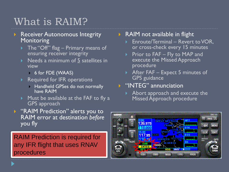
RAIM Prediction is required for
any IFR flight that uses RNAV
procedures
What is RAIM? Receiver Autonomous Integrity
Monitoring The “Off” flag – Primary means of
ensuring receiver integrity
Needs a minimum of 5 satellites in view
6 for FDE (WAAS)
Required for IFR operations
Handheld GPSes do not normally have RAIM
Must be available at the FAF to fly a GPS approach
“RAIM Prediction” alerts you to RAIM error at destination before you fly
RAIM not available in flight Enroute/Terminal – Revert to VOR,
or cross-check every 15 minutes
Prior to FAF – Fly to MAP and execute the Missed Approach procedure
After FAF – Expect 5 minutes of GPS guidance
“INTEG” annunciation Abort approach and execute the
Missed Approach procedure

GPS Accuracy vs. VOR
CDI Comparison
GPS: Fixed-width accuracy*
VOR: Accuracy varies with distance
Becomes more sensitive as you get closer
“Cone of confusion”
GNS 430 – “Resolver-Type” Design
Resolver Course Indicator Coupled to CDI
OBS Course Selector Must Be Set To DTK
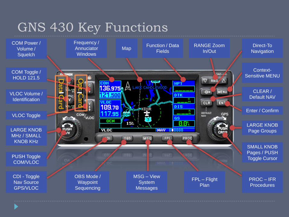
GNS 430 Key Functions COM Power /
Volume /
Squelch
COM Toggle /
HOLD 121.5
VLOC Volume /
Identification
VLOC Toggle
LARGE KNOB
MHz / SMALL
KNOB KHz
PUSH Toggle
COM/VLOC
CDI - Toggle
Nav Source
GPS/VLOC
OBS Mode /
Waypoint
Sequencing
MSG – View
System
Messages
FPL – Flight
Plan
PROC – IFR
Procedures
SMALL KNOB
Pages / PUSH
Toggle Cursor
LARGE KNOB
Page Groups
Enter / Confirm
CLEAR /
Default NAV
Context-
Sensitive MENU
Direct-To
Navigation
RANGE Zoom
In/Out
Frequency /
Annuciator
Windows
Function / Data
Fields Map
Data C
ard
Opt. C
ard
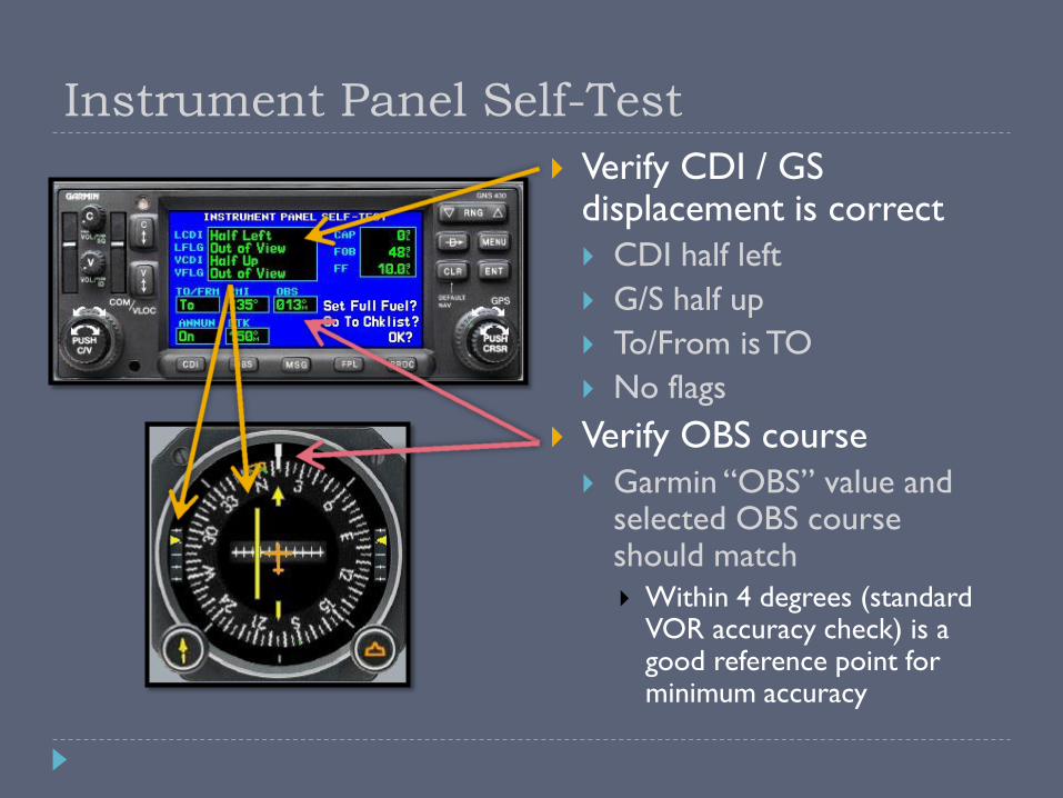
Instrument Panel Self-Test
Verify CDI / GS displacement is correct
CDI half left
G/S half up
To/From is TO
No flags
Verify OBS course
Garmin “OBS” value and selected OBS course should match
Within 4 degrees (standard VOR accuracy check) is a good reference point for minimum accuracy

Default Nav Page
The “home” page
Press and hold CLR to load from any other page
Active leg of flight plan TO/FROM flag*
Course deviation indicator (CDI)
User-selectable
data fields Current page group
(“chapter”) name
Individual pages in current page group
Position of current
page within
current page group
* Always TO when in GPS mode

GNS 430/530 Page Navigation
Thin
k o
f “ch
apte
rs”
Think of “pages”

GNS 430/530 Page Navigation
NAV group
How do I get to my destination?
Are there any hazards on the way (traffic, terrain, weather)?
WPT group
Where am I going, and what is available there?
The “AFD” section of the Garmin
AUX group
Flight planning and E6B-like utilities
System setup
NRST group
What is nearest to my current location?
“Big trouble, big knob”

Map Declutter
Pressing the “CLR” button cycles through the four modes
1. Removes all land data except rivers & lakes.
2. Removes all airspace except Prohibited & Restricted. Also removes NDBs, Intersections, and User waypoints.
3. Removes all data except the Active Flight Plan, Prohibited airspace, rivers, lakes, traffic, and lightning data.
While inbound to the FAF, an additional “-A” declutter mode (equivalent to -3 above) is automatically activated
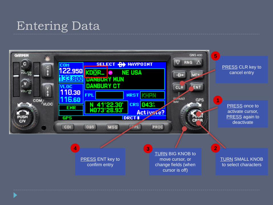
Entering Data
PRESS CLR key to
cancel entry
5
PRESS ENT key to
confirm entry
4 TURN BIG KNOB to
move cursor, or
change fields (when
cursor is off)
3
TURN SMALL KNOB
to select characters
2
PRESS once to
activate cursor,
PRESS again to
deactivate
1
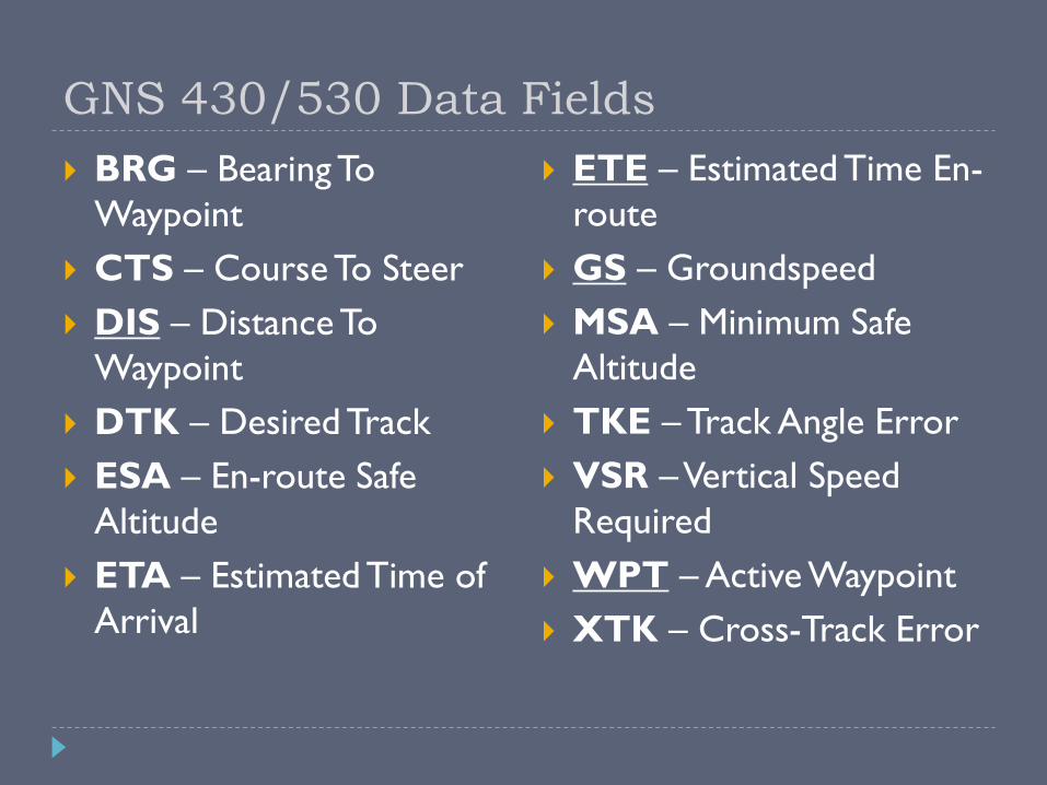
GNS 430/530 Data Fields
BRG – Bearing To
Waypoint
CTS – Course To Steer
DIS – Distance To
Waypoint
DTK – Desired Track
ESA – En-route Safe
Altitude
ETA – Estimated Time of
Arrival
ETE – Estimated Time En-
route
GS – Groundspeed
MSA – Minimum Safe
Altitude
TKE – Track Angle Error
VSR – Vertical Speed
Required
WPT – Active Waypoint
XTK – Cross-Track Error

Terrain Awareness
Terrain Awareness
Portrays a 2D picture of the surrounding terrain and
obstacles relative to the position and altitude of the
aircraft
Non-TSO-C151b terrain awareness system
Advisory-only
Separate terrain database updates
Obstacle and terrain databases are on the same card, but
updated at different intervals
Based off of GPS altitude, converted to MSL
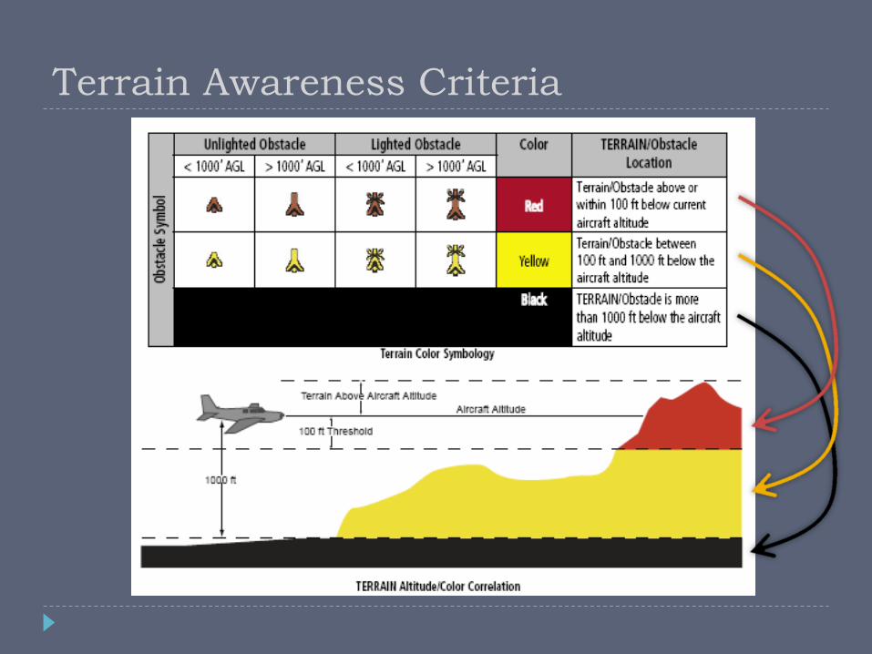
Terrain Awareness Criteria

Premature Descent Alert
Forward Looking Terrain Avoidance
Flashing Alert = Immediate Evasive Action Required!
Terrain Awareness Alerts
On-Screen Caution

Terrain Modes 360-view 120-view
Terrain Inhibit Notification

Traffic & Weather Pages
Traffic Page
From the “NAV” group
(chapter), use the right
little knob to select the
dedicated traffic page
Displays the 8 nearest
targets within a specified
filter range
Traffic data can also
optionally be shown on
the moving map page
Traffic Advisory (TA) – Traffic may
pose a collision threat.
Proximity Advisory (PA) – Traffic
Is within 6nm and +/- 1,200’
Other detected traffic
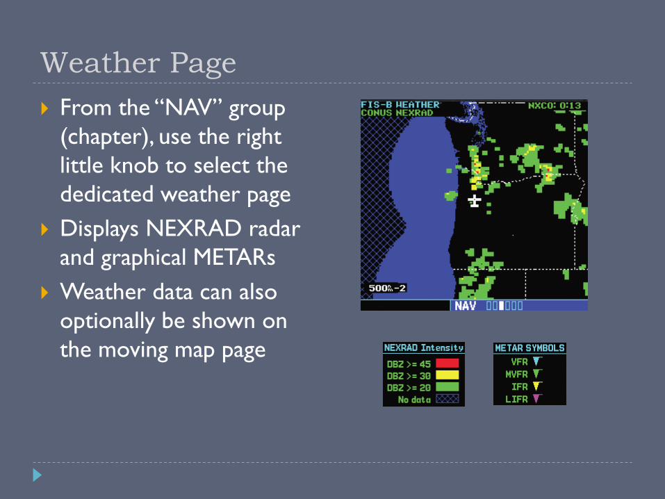
Weather Page
From the “NAV” group
(chapter), use the right
little knob to select the
dedicated weather page
Displays NEXRAD radar
and graphical METARs
Weather data can also
optionally be shown on
the moving map page
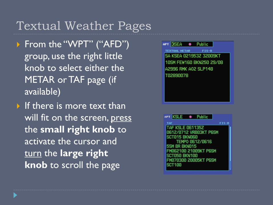
Textual Weather Pages
From the “WPT” (“AFD”)
group, use the right little
knob to select either the
METAR or TAF page (if
available)
If there is more text than
will fit on the screen, press
the small right knob to
activate the cursor and
turn the large right
knob to scroll the page

Useful Features & Tips
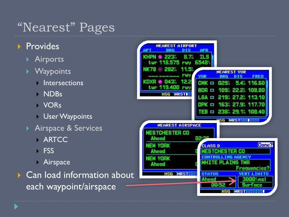
“Nearest” Pages
Provides
Airports
Waypoints
Intersections
NDBs
VORs
User Waypoints
Airspace & Services
ARTCC
FSS
Airspace
Can load information about
each waypoint/airspace
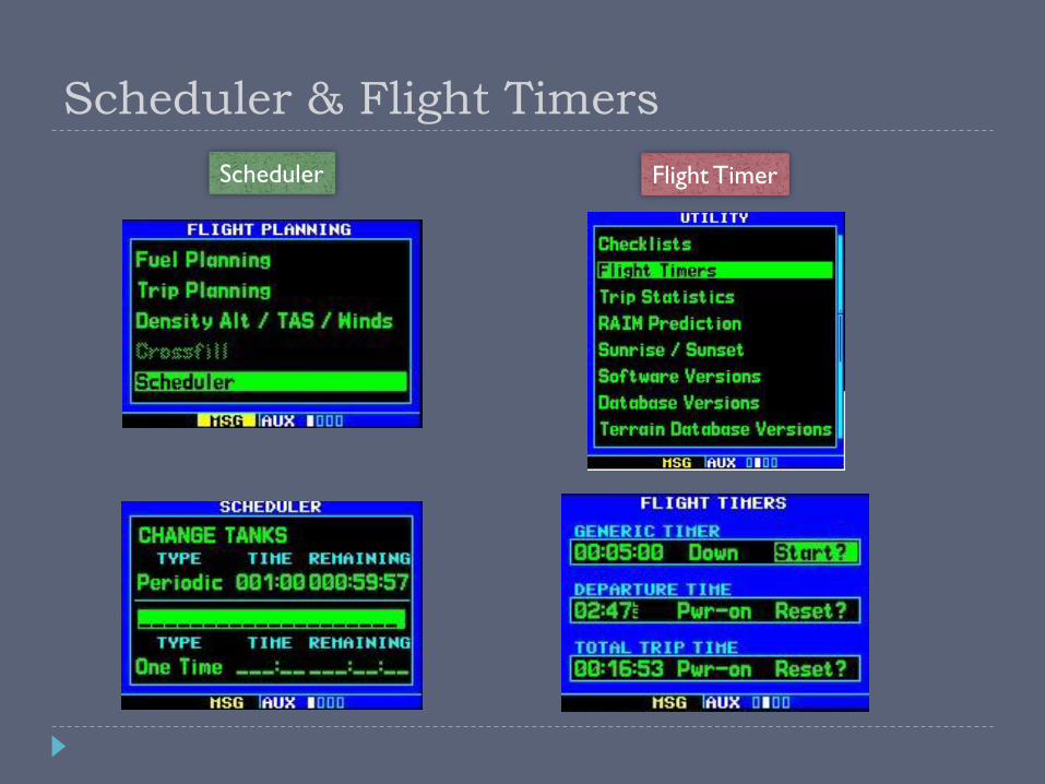
Scheduler & Flight Timers
Scheduler Flight Timer
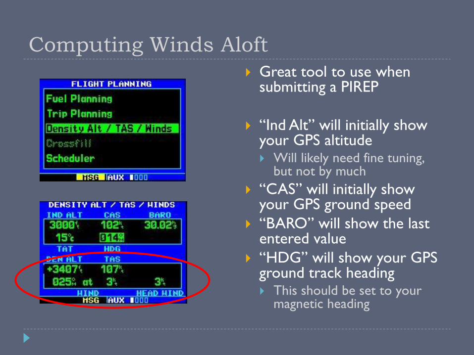
Computing Winds Aloft
Great tool to use when submitting a PIREP
“Ind Alt” will initially show your GPS altitude Will likely need fine tuning,
but not by much
“CAS” will initially show your GPS ground speed
“BARO” will show the last entered value
“HDG” will show your GPS ground track heading This should be set to your
magnetic heading
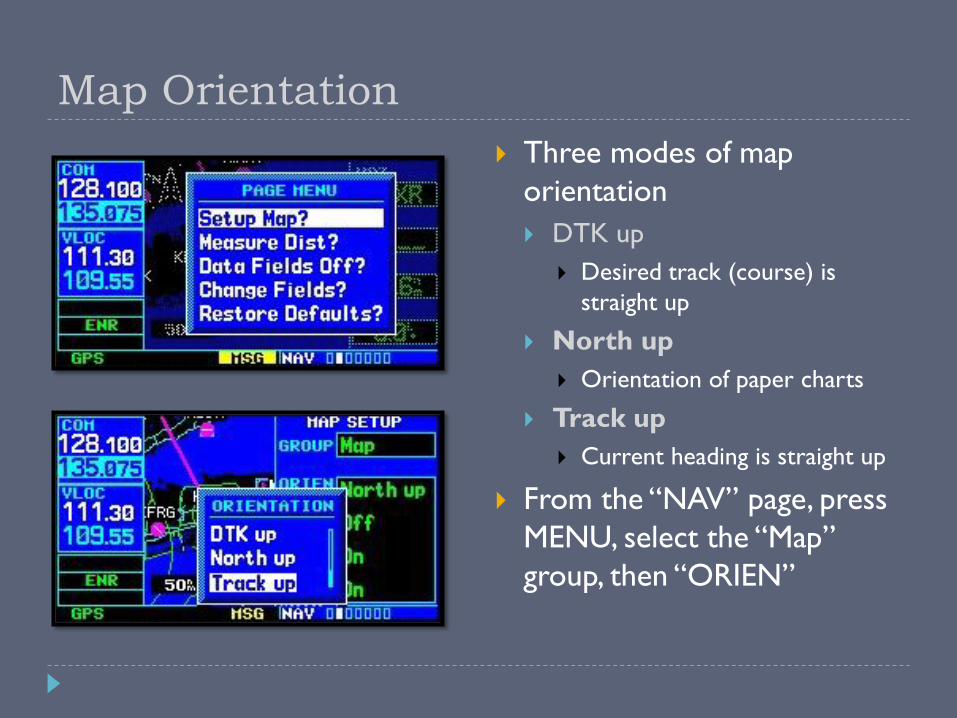
Map Orientation
Three modes of map
orientation
DTK up
Desired track (course) is
straight up
North up
Orientation of paper charts
Track up
Current heading is straight up
From the “NAV” page, press
MENU, select the “Map”
group, then “ORIEN”
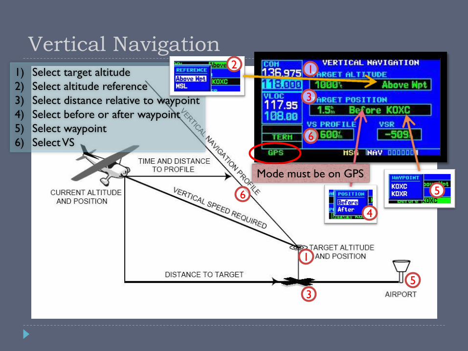
Vertical Navigation
Mode must be on GPS
1) Select target altitude
2) Select altitude reference
3) Select distance relative to waypoint
4) Select before or after waypoint
5) Select waypoint
6) Select VS
1
3
4
5
6
2
1
5
6
3
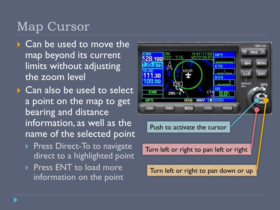
Map Cursor
Can be used to move the map beyond its current limits without adjusting the zoom level
Can also be used to select a point on the map to get bearing and distance information, as well as the name of the selected point
Press Direct-To to navigate direct to a highlighted point
Press ENT to load more information on the point
Push to activate the cursor
Turn left or right to pan left or right
Turn left or right to pan down or up

User-Defined Waypoints
Up to 1000 user-defined waypoints can be stored
Can be created from the User Waypoint page or from the Map page
User waypoints are referenced by name only
Do not create a user waypoint with the same name as a real waypoint!
User waypoints are best
used for ground
references (houses, etc) or
common reporting points
(e.g. “the prison” at
KDXR)

Restoring Default Settings
Resetting the four user-
selectable data fields
Press the MENU button,
use the big knob on the
right to select “Restore
Defaults?”, and press ENT
Resetting AUX page
settings
From the setting page to
reset, press the MENU
button and press ENT

Garmin PC Simulator
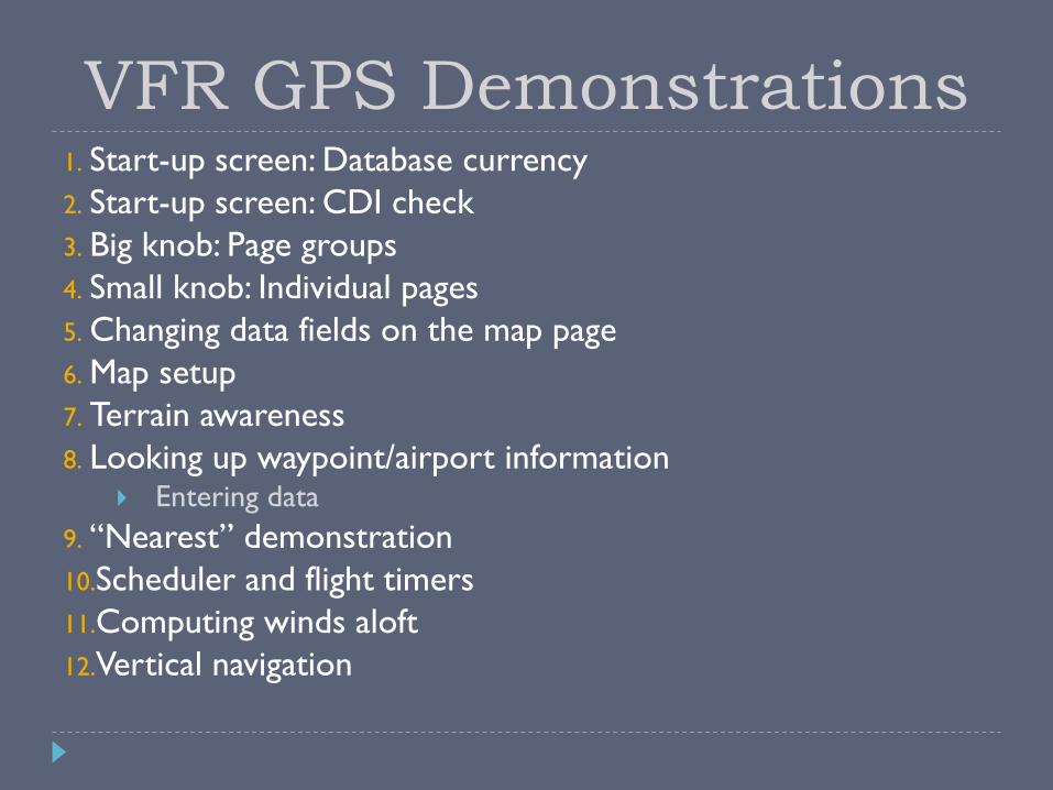
1. Start-up screen: Database currency
2. Start-up screen: CDI check
3. Big knob: Page groups
4. Small knob: Individual pages
5. Changing data fields on the map page
6. Map setup
7. Terrain awareness
8. Looking up waypoint/airport information Entering data
9. “Nearest” demonstration
10.Scheduler and flight timers
11.Computing winds aloft
12.Vertical navigation
VFR GPS Demonstrations

GPS Do’s and Don’ts
DO DON’T
Develop skills in stages
Practice with PC
simulators
Program on the ground
Delegate GPS operations
to copilot
Fly the airplane first!
Exceed VFR or personal minimums
Focus inside the cockpit
Rely solely on GPS map display for navigation
Fiddle with it while close to an airport or in a high workload situation
Try new features for the first time in the air
GPS is Not a Substitute for Sound ADM!! “Proper Prior Planning Prevents Poor Performance!”
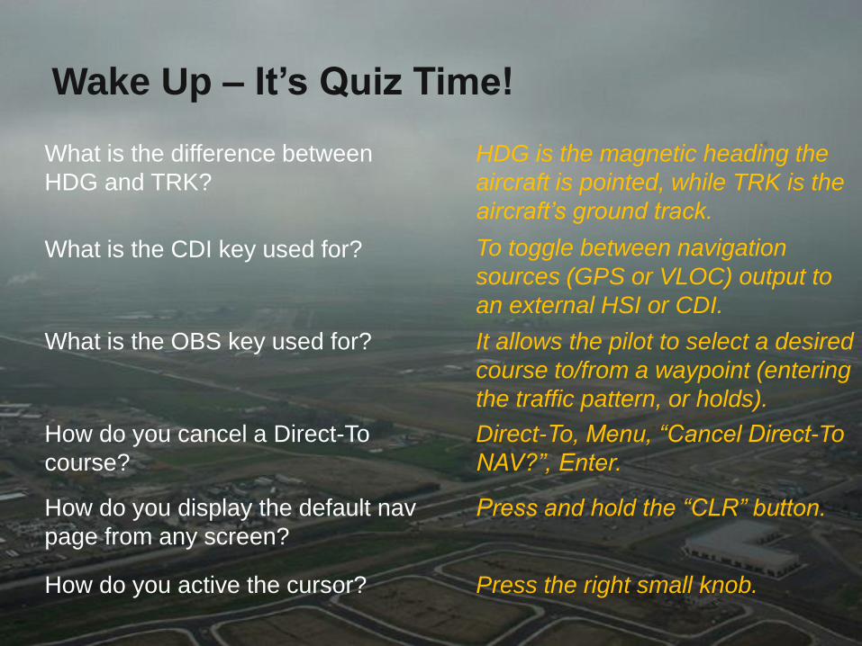
Wake Up – It’s Quiz Time!
How do you active the cursor?
What is the CDI key used for?
How do you cancel a Direct-To
course?
What is the difference between
HDG and TRK?
What is the OBS key used for?
How do you display the default nav
page from any screen?
HDG is the magnetic heading the
aircraft is pointed, while TRK is the
aircraft’s ground track.
To toggle between navigation
sources (GPS or VLOC) output to
an external HSI or CDI.
It allows the pilot to select a desired
course to/from a waypoint (entering
the traffic pattern, or holds).
Direct-To, Menu, “Cancel Direct-To
NAV?”, Enter.
Press and hold the “CLR” button.
Press the right small knob.

IFR GPS Operations

Alternate means of navigation required – FAR 91.205
A non-GPS approach must be available at alternate airport (or VFR)
No longer required with WAAS (TSO C-146a)
File /G – IFR RNAV-Capable Aircraft
ICAO: B2 (RNAV 5 GNSS), C2 (RNAV 2 GNSS), D2 (RNAV 1 GNSS)
Are You IFR Legal? IFR-Certified GPS Unit
Garmin 430/530
TSO C-129a Certified for IFR Enroute and Approach
Garmin 430W/530W
WAAS TSO C-146a Certified for sole source of navigation
IFR-Certified Installation
Installation must also be certified! (AC20-138)
AFM Supplement must be in the aircraft
Database current (Updated every 28 days)?*
IFR Usage
May be used in lieu of ADF and DME*
Review GPS/WAAS NOTAMs and “All available information” – FAR 91.103
* = More details provided on a later slide
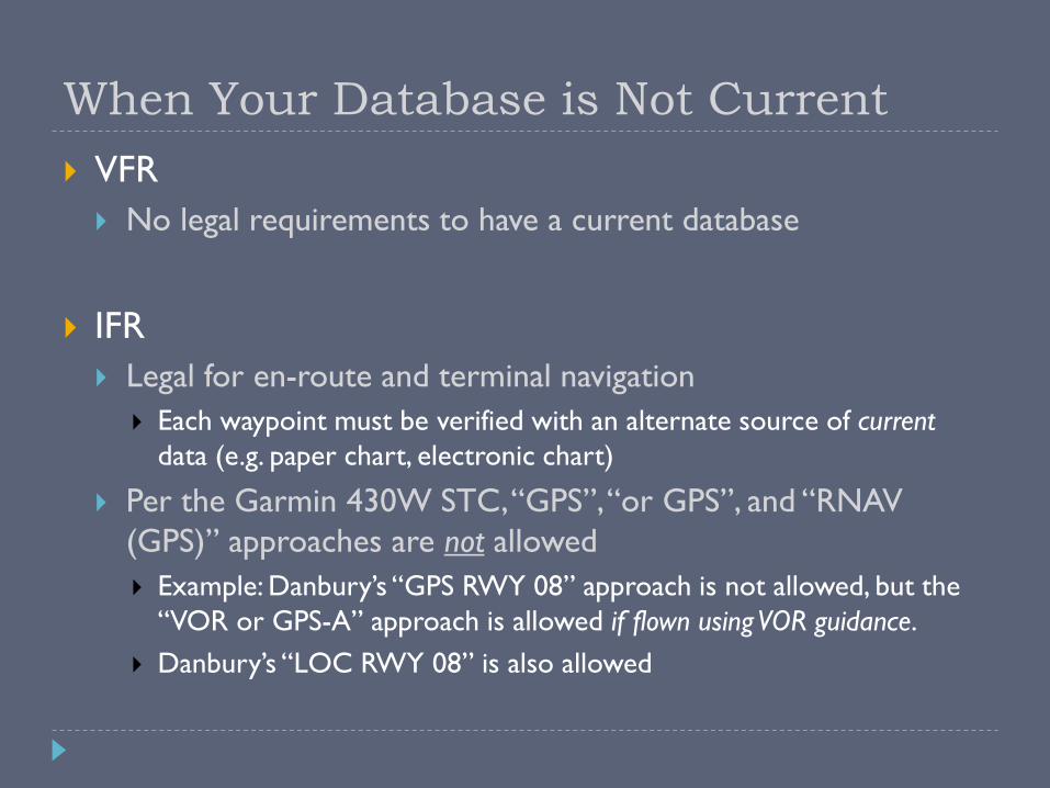
When Your Database is Not Current
VFR
No legal requirements to have a current database
IFR
Legal for en-route and terminal navigation
Each waypoint must be verified with an alternate source of current
data (e.g. paper chart, electronic chart)
Per the Garmin 430W STC, “GPS”, “or GPS”, and “RNAV
(GPS)” approaches are not allowed
Example: Danbury’s “GPS RWY 08” approach is not allowed, but the
“VOR or GPS-A” approach is allowed if flown using VOR guidance.
Danbury’s “LOC RWY 08” is also allowed
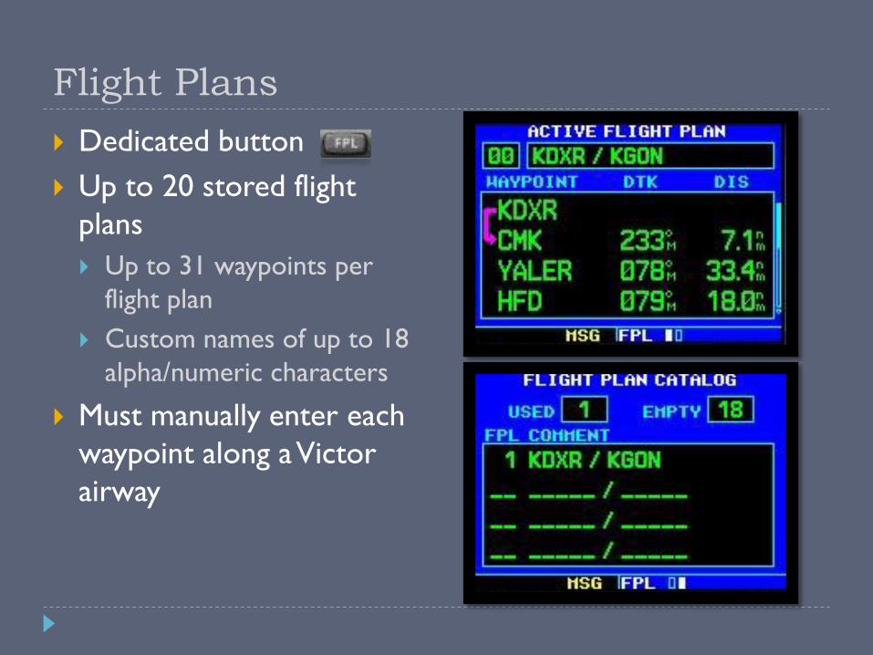
Flight Plans
Dedicated button
Up to 20 stored flight
plans
Up to 31 waypoints per
flight plan
Custom names of up to 18
alpha/numeric characters
Must manually enter each
waypoint along a Victor
airway

Activating a Leg
Two ways to activate a leg
Using Direct-To
1. Select the first waypoint along the leg
2. Direct-Direct
3. Enter
Using Menu
1. Select the first waypoint along the leg
2. Menu, highlight “Activate Leg?” (should be highlighted by default),
Enter
3. Enter
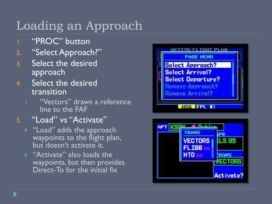
Loading an Approach
1. “PROC” button
2. “Select Approach?”
3. Select the desired approach
4. Select the desired transition
1. “Vectors” draws a reference line to the FAF
5. “Load” vs “Activate” “Load” adds the approach
waypoints to the flight plan, but doesn’t activate it.
“Activate” also loads the waypoints, but then provides Direct-To for the initial fix

Flight Plans with Multiple Destinations
Switching approaches
1. Press “PROC”, select “Select Approach?”, “ENT”
2. Press “MENU”, “MENU”
3. Scroll to “Select Next FPL Apt?” and press “ENT”
Reasons
Easily load an approach for the departure or alternate airport
Simplify IFR training / proficiency
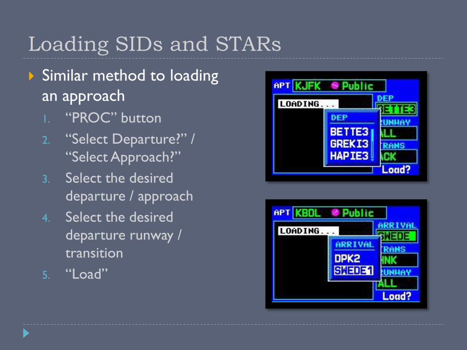
Loading SIDs and STARs
Similar method to loading
an approach
1. “PROC” button
2. “Select Departure?” /
“Select Approach?”
3. Select the desired
departure / approach
4. Select the desired
departure runway /
transition
5. “Load”

Intro to GPS Approaches
1st Generation – Non-
precision VOR/NDB
overlay approaches
(RNAV)
2nd Generation – Stand-
alone non-precision GPS
approaches (RNAV)
3rd Generation – WAAS
approach with vertical
guidance
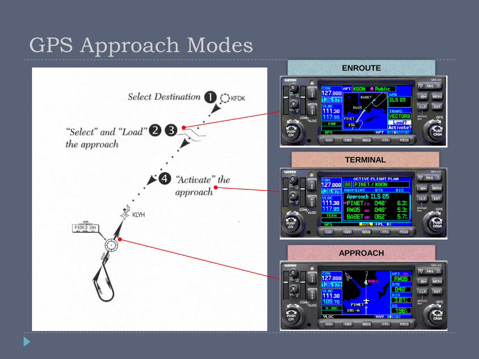
ENROUTE
TERMINAL
APPROACH
GPS Approach Modes

CDI Scale Transitions
During the transition phases, the CDI may give the
impression that you are off course, even though you
may be on a perfectly good intercept angle.
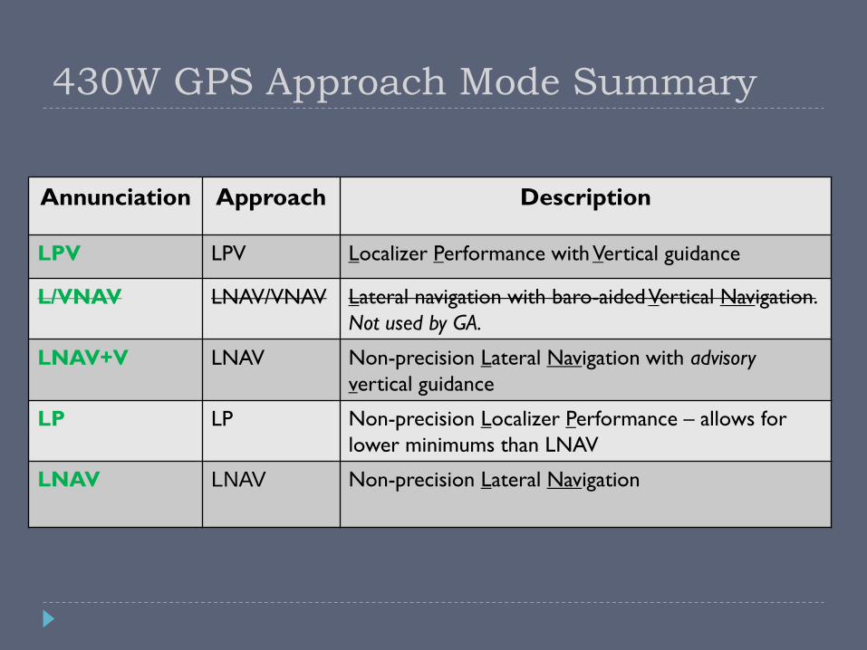
Annunciation Approach Description
LPV LPV Localizer Performance with Vertical guidance
L/VNAV LNAV/VNAV Lateral navigation with baro-aided Vertical Navigation.
Not used by GA.
LNAV+V LNAV Non-precision Lateral Navigation with advisory
vertical guidance
LP LP Non-precision Localizer Performance – allows for
lower minimums than LNAV
LNAV LNAV Non-precision Lateral Navigation
430W GPS Approach Mode Summary
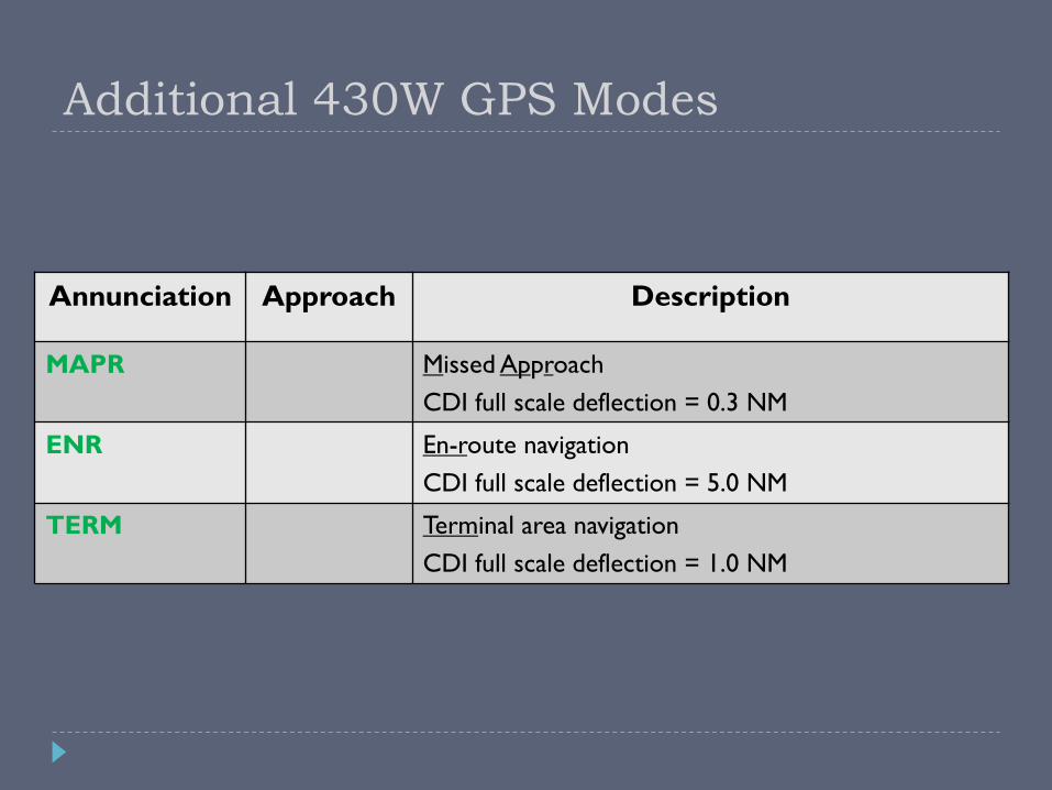
Annunciation Approach Description
MAPR Missed Approach
CDI full scale deflection = 0.3 NM
ENR En-route navigation
CDI full scale deflection = 5.0 NM
TERM Terminal area navigation
CDI full scale deflection = 1.0 NM
Additional 430W GPS Modes
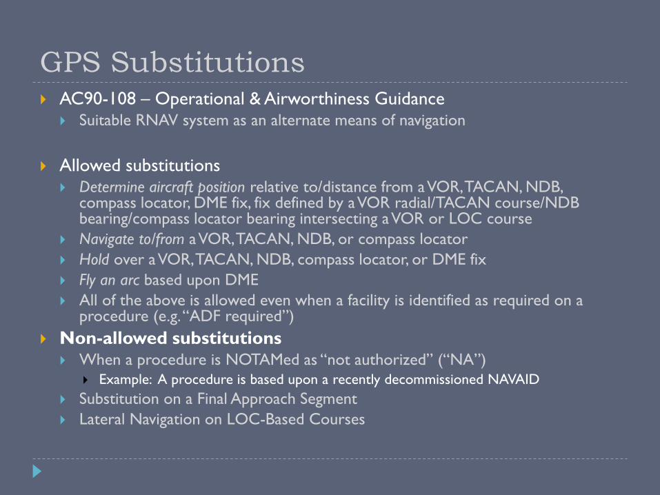
GPS Substitutions AC90-108 – Operational & Airworthiness Guidance
Suitable RNAV system as an alternate means of navigation
Allowed substitutions Determine aircraft position relative to/distance from a VOR, TACAN, NDB,
compass locator, DME fix, fix defined by a VOR radial/TACAN course/NDB bearing/compass locator bearing intersecting a VOR or LOC course
Navigate to/from a VOR, TACAN, NDB, or compass locator
Hold over a VOR, TACAN, NDB, compass locator, or DME fix
Fly an arc based upon DME
All of the above is allowed even when a facility is identified as required on a procedure (e.g. “ADF required”)
Non-allowed substitutions When a procedure is NOTAMed as “not authorized” (“NA”)
Example: A procedure is based upon a recently decommissioned NAVAID
Substitution on a Final Approach Segment
Lateral Navigation on LOC-Based Courses
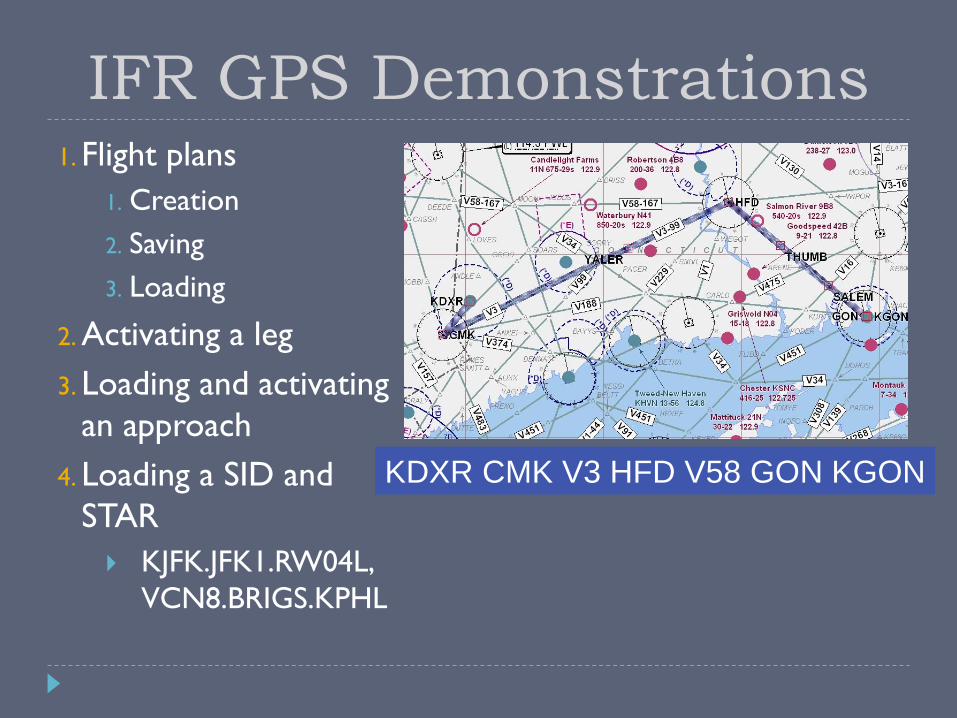
KDXR CMK V3 HFD V58 GON KGON
IFR GPS Demonstrations 1. Flight plans
1. Creation
2. Saving
3. Loading
2. Activating a leg
3. Loading and activating
an approach
4. Loading a SID and
STAR
KJFK.JFK1.RW04L,
VCN8.BRIGS.KPHL
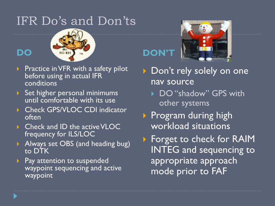
IFR Do’s and Don’ts
DO DON’T
Practice in VFR with a safety pilot before using in actual IFR conditions
Set higher personal minimums until comfortable with its use
Check GPS/VLOC CDI indicator often
Check and ID the active VLOC frequency for ILS/LOC
Always set OBS (and heading bug) to DTK
Pay attention to suspended waypoint sequencing and active waypoint
Don’t rely solely on one nav source
DO “shadow” GPS with other systems
Program during high workload situations
Forget to check for RAIM INTEG and sequencing to appropriate approach mode prior to FAF
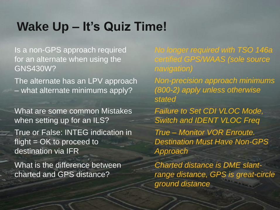
Wake Up – It’s Quiz Time!
The alternate has an LPV approach
– what alternate minimums apply?
True or False: INTEG indication in
flight = OK to proceed to
destination via IFR
Is a non-GPS approach required
for an alternate when using the
GNS430W?
What are some common Mistakes
when setting up for an ILS?
What is the difference between
charted and GPS distance?
No longer required with TSO 146a
certified GPS/WAAS (sole source
navigation)
Non-precision approach minimums
(800-2) apply unless otherwise
stated
Failure to Set CDI VLOC Mode,
Switch and IDENT VLOC Freq
True – Monitor VOR Enroute.
Destination Must Have Non-GPS
Approach
Charted distance is DME slant-
range distance, GPS is great-circle
ground distance

More Information Garmin Website –
http://www.garmin.com GNS 430 manual
GNS 430 PC Simulator
http://tinyurl.com/kytjvqe
Training Syllabus
Avweb – http://www.avweb.com
YouTube (IFR Magazine, Garmin) http://www.youtube.com/watch?v=zo
fn3skychQ
http://www.youtube.come/watch?v=d1P0RliayIQ
AOPA Air Safety Foundation – http://www.aopa.org/asf ASF Safety Advisor – GPS Technology
Open Sky Aviation, LLC.
http://openskyaviation.biz
Special thanks to Brad Freeman for the original course material
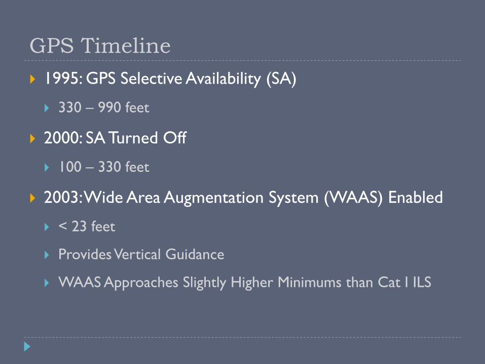
GPS Timeline
1995: GPS Selective Availability (SA)
330 – 990 feet
2000: SA Turned Off
100 – 330 feet
2003: Wide Area Augmentation System (WAAS) Enabled
< 23 feet
Provides Vertical Guidance
WAAS Approaches Slightly Higher Minimums than Cat I ILS
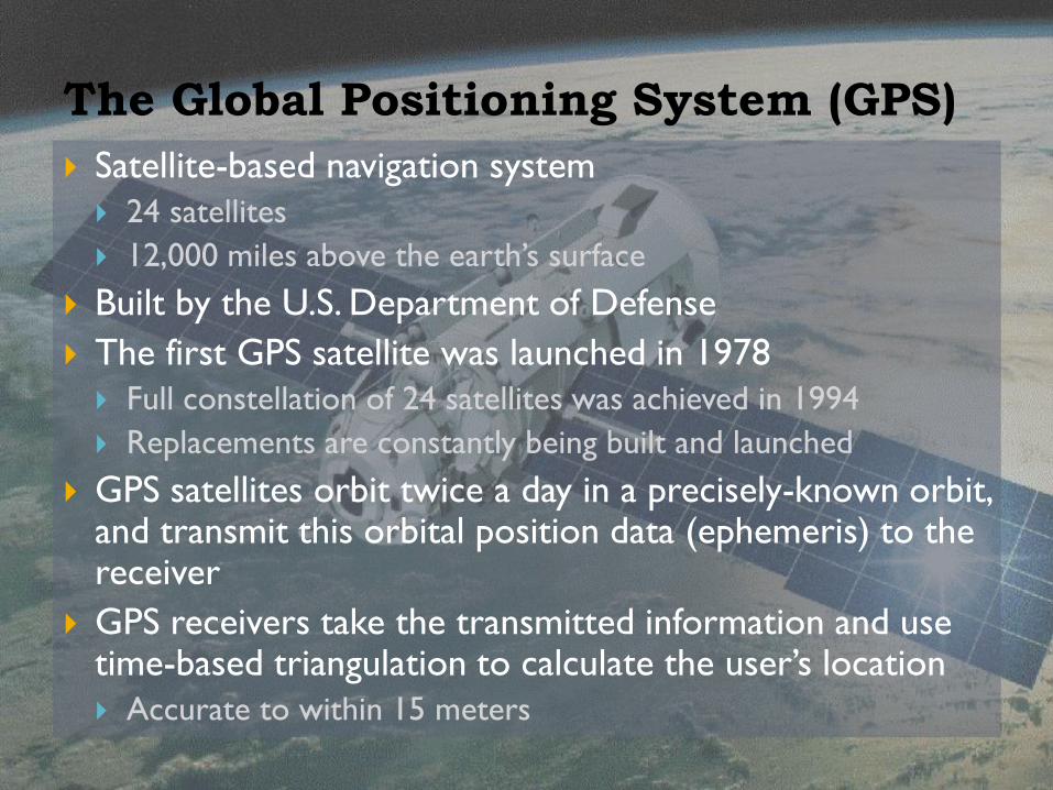
The Global Positioning System (GPS)
Satellite-based navigation system
24 satellites
12,000 miles above the earth’s surface
Built by the U.S. Department of Defense
The first GPS satellite was launched in 1978
Full constellation of 24 satellites was achieved in 1994
Replacements are constantly being built and launched
GPS satellites orbit twice a day in a precisely-known orbit, and transmit this orbital position data (ephemeris) to the receiver
GPS receivers take the transmitted information and use time-based triangulation to calculate the user’s location
Accurate to within 15 meters

What is WAAS?
Wide Area Augmentation System Corrects for GPS signal errors caused by ionospheric disturbances
and satellite orbit errors
A network of ground reference stations at precisely-surveyed locations Compare GPS distance measurements to known values
Each ground reference station is linked to a master station, which generates a correction signal and transmits it to one of two geostationary satellites
Correction signal is then broadcast to WAAS-capable receivers
Covers entire USA (and some of Canada and Mexico)
WAAS position accuracies 1 meter horizontal
2 meters vertical
Up to 5x better than standard GPS
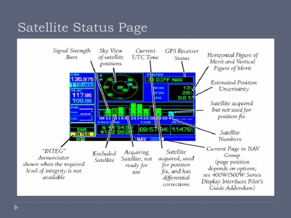
Satellite Status Page

Basic Navigation
Provides basic navigation
information, derived from
GPS data
GPS ground track
GPS ground speed
GPS altitude
Compass tape (based on
ground track) can be used
to supplement the
magnetic compass when
making compass turns.