garfield county community wildfire protection …
TRANSCRIPT

Garfield County
Community Wildfire Protection Plan
Garfield County Community Wildfire Protection Plan
The Garfield County Community Wildfire Protection Plan has been prepared by, reviewed and/or approved by the following signatories:
Prepared by: Bruce Suenram, Fire Logistics, Inc.
Chair, Board of County Commissioners
Garfield County Fire Warden
BLM – Miles City Field Office
Charles M. Russell National Wildlife Refuge
Eastern Land Office, MT Dept. of Natural Resources & Conservation
July 2007 Page 2
Garfield County Community Wildfire Protection Plan
GARFIELD COUNTY COMMUNITY WILDFIRE PROTECTION PLAN 1. Executive Summary 1.1. Problem Overview Garfield County is a large county located in northeastern Montana. It covers just under 5,000 square miles, of which approximately 180 square miles are covered by water, primarily from Fort Peck Lake. It is bisected by State Highway 200 running from east to west through Jordan, the approximate center of the county. Jordan is also the county seat and has a population of less than 500 people. State Highway 59 runs from Jordan down to the southeastern corner of the state toward Miles City. There are no other major paved roads in the county but there is an extensive secondary road system, most of which does not have an all weather surface. The general quality of the existing roads, rugged terrain features of the timbered Missouri River breaks and the road use policies on some federal lands makes access to lightning caused ignitions a continuing problem for the county fire protection organization. Under the current drought conditions, Garfield County has a high degree of potential for extended fire seasons ranging from March through October or November. Garfield County Fire Department, under the leadership of Ray Hageman, is responsible for wildland fire protection and structure fire protection on state and private lands throughout the county. The department is also responsible for taking action on those fires on federal lands that threaten state or private land. Ray has strategically located engines based on fire potential and historical fire occurrence throughout the county. In contrast to most eastern Montana counties, there are few Montana Department of Natural Resources and Conservation apparatus positioned in Garfield County under the county coop program. Garfield County frequently interacts with the Charles M. Russell National Wildlife Refuge (CMR) and the Bureau of Land Management (BLM) since many of their lands are either intermingled or adjacent to county protection responsibilities. This provides a certain level of interagency complexity in dealing with wildland fires in the county. As with many counties in Montana, there is an increasing development of wildland-urban interface areas with potential access problems and a general lack of understanding by homeowners of the need for an asset protection zone to protect their homes and property. As a matter of general occurrence, Garfield County Fire Department has to deal with multiple ignitions throughout the county, particularly the timbered north and northwest portions, from lightning storms. 1.2. Process Overview The Garfield County Community Wildfire Protection Plan, hereafter known as “CWPP,” has been developed to assist Garfield County, Garfield County Fire Department and the federal and state wildland agencies in the identification of private and public lands at risk of severe wildland fires and to explore strategies for the prevention and suppression of such fires. The CWPP is intended to outline the Garfield County Fire Department’s plans and activities targeted at reducing the risk of a catastrophic wildland and/or wildland-urban interface (WUI) fire event in Garfield County. The intent of this planning document will ensure that the health, safety and welfare of Garfield County’s citizens remain secure from the threats of structural and wildland fires in the county. 1.3. Overall Goals The CWPP will improve planning and fire suppression tools for county and the county fire department alike, which will result in Garfield County providing its citizens with tools to live more safely in a fire prone ecosystem. The CWPP fosters the preservation of the economy of Garfield County by maintaining and
July 2007 Page 3

Garfield County Community Wildfire Protection Plan
improving the fire protection capability of the County. 1.4. Methodology Fire Logistics uses a Geographic Information System (GIS) based analysis approach to development of the fire hazard assessment for Garfield County. This approach enables personnel from Fire Logistics to look at specific areas of high risk in the county such as wildland-urban interface and focus on items that would be included in the mitigation plan as recommended projects. 1.5. Mitigation Strategy – The Action Plan This is a summary of the specific actions, which are developed in the mitigation plan of Chapter 7 to include mitigation goals such as evaluate upgrade and maintain emergency wildfire protection responsibilities, decrease fuels, etc. The assumptions for planning priorities of the community fire plan are: protect human health and life, protect critical community infrastructure, protect private property, and protect natural resources. The existing mitigation efforts are described, which include asset protection zones, neighborhood preparedness and fire protection response, and the coordination of prevention protection projects and response plans. Several recommended projects and programs are included as part of the mitigation effort for Garfield County.
July 2007 Page 4

Garfield County Community Wildfire Protection Plan
2. Introduction 2.1. Background and History Garfield County Fire Department retained Fire Logistics, Inc. in September of 2005 to:
Develop a countywide Community Wildfire Protection Plan (CWPP) that meets NFP and HFRA for Garfield County. The CWPP must be a stand alone plan. The process must follow the guidance specified in Preparing a Community Wildfire Protection Plan - A Handbook for Wildland-Urban Interface Communities. This document is a collaboration of a number of organizations, and can be found at the website for the Society of American Foresters http://www.safnet.org/policyandpress/cwpphandbook.pdf . All the elements listed in the “Summary and Checklist” of this planning guide must be covered in the CWPP; the term “forest areas” should be understood to include all vegetation types that may be subject to wildfire. Mapped components must be provided in both hard copy and GIS layers.
2.2. Mission The mission of the Garfield County Fire Department is:
“To safely protect the lives of our firefighters and to protect the lives and property of the residents of Garfield County to the best of our ability and in the most efficient manner possible.”
2.3. Current Relevant Fire Policies A brief discussion of the relevant fire policies is provided to educate the leaders and residents of Garfield County. 2.3.1. Federal Policies “Homeland Security is Fire Safety” We will briefly describe the relevant policies at the national level, which affect fire planning on the local level. 2.3.1.1. National Fire Plan “The National Fire Plan (NFP) is a long-term investment that will help protect communities and natural resources, and most importantly, the lives of firefighters and the public. It is a long term commitment based on cooperation and communication among federal agencies, states, local governments, tribes and interested publics.” It mandates community participation in its implementation.1 The NFP also mandates that local governments develop and adopt local land use plans and ordinances that provide for the maintenance of defensible space and fuel management on municipal and private property.2 2.3.1.2 Disaster Mitigation Act 2000 Disaster Mitigation Act 2000 (DMA 2000) sets policies for “disaster mitigation plans”—plans designed to avoid disasters such as fires and floods. DMA 2000 requires 4 elements in these plans:
A planning process. An assessment of risks. A mitigation strategy (action plan) and, A maintenance plan and updating process.
1 See www.fireplan.gov. 2 See www.westgov.org/wga/initiatives/fire/implem_plan.pdf
July 2007 Page 5

Garfield County Community Wildfire Protection Plan
2.3.1.3. Western Governor’s Association, 10-Year Comprehensive Strategy for Reducing Wildland Fire Risks3 and A Collaborative Approach for Reducing Wildland Fire Risks to Communities and the Environment—Implementation Plan The goals of the 10-Year Comprehensive Strategy are to:
Improve Prevention and Suppression Reduce Hazardous Fuels Restore Fire Adapted Ecosystems Promote Community Assistance.
This is done through a “Framework for Collaboration… Local Level—Successful implementation will include stakeholder groups with broad representation including Federal, State, and local agencies, tribes and the public, collaborating with local line officers on decision making to establish priorities, cooperation on activities, and increase public awareness and participation to reduce the risks to communities and environments.”4 2.3.1.4. Local Implementation of Federal Fire Policies Fire protection objectives on the state and private lands in Garfield County are addressed indirectly in the Cooperative Fire Management Agreement between USDI’s Bureau of Land Management, National Park Service – Intermountain Region, Bureau of Indian Affairs – Portland and Billings Area, US Fish and Wildlife Service – Rocky Mountain Region; USDA’s Forest Service – Northern Region; and the State of Montana – Department of Natural Resources and Conservation. This agreement requires that the parties to the agreement develop and approve Annual Operating Plans by May 1 of each year specifying how the terms of the agreement will be carried out between the cooperating agencies and the state. Cooperation with local county governments is encouraged and additional agreements may be made with counties through the State of Montana. These agreements are to validate the arrangements desired between the county and a federal agency or the state in respect to assistance with their fire management programs. The procedures for obtaining state and federal assistance for large wildland fire, should the circumstance occur, needs to be clarified in any agreements prepared at the local level. They should include an articulation of the suppression standards that need to be employed by federal or state agencies working on a fire on state and private land. The reverse is also true for county resources working on federal or state lands. In the former case the objective will most likely be to suppress the fire at the smallest size possible utilizing the full range of suppression resource available. In the latter case, however, certain land management objectives may preclude this approach, i.e., mechanical equipment in sensitive areas. Generally, some counties may not have the skills, resources or the interest to pursue a comprehensive fire use program. They are more interested in, and in some cases dependent upon, help with their fire suppression program. Such is not the case in Garfield County where fire suppression is ably handled by the county and a desire to improve skills in the use of prescribed fire is actively pursued. A potential conflict of interests could develop should the CMR or BLM decide to implement a wildland fire use program whereby certain natural ignitions would be allowed to burn to accomplish resource management benefits. Neither of these agencies have large enough contiguous areas that would provide a reasonable assurance that the fires would not leave the respective agencies jurisdiction at some point, particularly considering the duration of the event and its eventual exposure to some type of major wind event. At the point the fire left federal lands the county would become the recipient and would have to suppress it, probably at considerable cost and risk. There may be circumstances where a fire is human caused and assistance in an investigation is needed. The skill to be a fire investigator can either be developed within the county or it can be brought in from another agency on an as needed basis. Whichever route is chosen, there should be no delay in utilizing a 3 www.westgov.org/wga/initiatives/fire/final_fire_rpt.pdf4 www.westgov.org/wga/initiatives/fire/implem_plan.pdf
July 2007 Page 6

Garfield County Community Wildfire Protection Plan
fire investigator when the situation is warranted. 2.3.2. State Policies Currently there are no State policies that require a rural fire district or county fire organization to develop a community fire plan. It is the policy of the State to complete pre-disaster mitigation plans in compliance with the Federal direction as noted above. 2.3.3. Local Policies The Garfield County Commissioners have an up-dated Growth Policy for the county in 2004. The other land use document that affects fire service delivery by the Garfield County Fire Department is the Subdivision Regulations of Garfield County (See Subdivision Regulations in Resources Section). Those subdivision regulations were adopted in September of 2006. The purposes of the Garfield County Subdivision Regulations are to promote public health, safety and general welfare by regulating the subdivision of land, providing ingress and egress, and etc. They also support the purposes of 76-3-102 MCA. The subdivision regulations are intended to promote the coordination of roads within subdivided lands with other roads, both existing and planned, the avoidance of danger or injury by reason of natural hazard or the lack of water, drainage, access, transportation or other public services, and the avoidance of excessive expenditure of public funds for the supply of public services. There is an existing county disaster plan, which has a wildfire annex; the pre-disaster mitigation plan is in development and will be adopted by Garfield County in the near future. There is some general guidance in the Jordan City-County Growth Policy Plan addressing Community Facilities and Services goal which states:
“Provide public facilities and services that are adequate and cost-effective to serve residents and businesses, and at reasonably public costs and tax expenditures.”
One of the Economic Development objectives states: “Retain and expand existing businesses and industries, promote local business start-ups, and
foster recruitment of business to locate in Jordan and Garfield County.” The Town of Jordan Capital Improvements Plan, 2005, discusses many capital improvements needed, but fails to mention fire stations or fire apparatus. 2.4. Planning Area Boundaries
Figure 1.
The Garfield County CWPP covers Garfield County in its entirety. The county has been further subdivided into sub-planning areas by the 5th Code Watershed. The purpose of the 5th Code Watershed is to provide a uniquely identified and uniformed method of subdividing large drainage areas. These smaller, 5th Code Watershed units are approximately 40,000 acres to 250,000 acres and are useful for fire planning purposes as well as other programs by the Natural Resources and Conservation Service and other agencies in Figure 1 (See
July 2007 Page 7

Garfield County Community Wildfire Protection Plan
Planning Area Map in Map Section 10.5). 2.5. Community Legal Structure, Jurisdictional Boundaries There is a mixture of fire protection organizations providing fire services to Garfield County. These include Jordan Fire Department (MCA 7-33-4101-4133), Garfield County Fire Department (MCA 7-33-2201-2211), MT Department of Natural Resources and Conservation – County Cooperative Program, Fish and Wildlife Service, and Bureau of Land Management.
Jordan Fire Department provides structural and wildland fire services to the residents of the Jordan and mutual aid to Garfield County Fire Department. There is no written mutual aid agreement. Garfield County Fire Department provides wildland fire protection and very limited structure fire services throughout the county. The Bureau of Land Management is the responsible land management agency for BLM lands and assists the local agencies as needed. The Charles M. Russell National Wildlife Refuge (FWS) is the responsible land management agency for Refuge lands and assists the local agencies as needed. The Department of Natural Resources and Conservation – County Cooperative Program provides fire support to counties when the county’s capability has been exceeded and assistance is requested.
2.6. Acknowledgements Fire Logistics, Inc. would like to thank the Garfield County Fire Department, especially Chief Ray Hageman; Garfield County Conservation District, especially Rachel Takala; Garfield County Weed District; Bureau of Land Management, especially Dena Sprandel-Lang and Danny Williams; Mike Granger and the fire staff at Charles M. Russell National Wildlife Refuge; Randy Sanders, Eastern Land Office, MT Department of Natural Resources and Conservation; and Garfield County Board of County Commissioners for their contributions to this plan.
July 2007 Page 8
Garfield County Community Wildfire Protection Plan
3. Planning Process 3.1. Current Process and Plan Development In the fall of 2005, the Garfield County Conservation District awarded a contract to Fire Logistics, Inc. to complete a comprehensive risk assessment of Garfield County and to develop a mitigation plan which provides recommendations for improvements to the county’s fire protection system, mitigation measures for treating the fuels and providing protection to structures. The Garfield County Community Wildfire Protection Plan (CWPP) is the result of that effort. 3.1.1. Avenues of Community and Public Input The draft Garfield County CWPP was submitted for review and comment on December 7, 2006. Comments were incorporated into the final draft of the Garfield County CWPP. 3.2. Review of Existing Plans, Studies, Reports, Technical Documents The following documents have been analyzed for materials, which may need to be referenced and incorporated in the Garfield County CWPP: Jordan City-County Growth Policy Plan, 2004 Zoning Ordinance, Town of Jordan, November 2004 Capital Improvements Plan, Town of Jordan, June 2005 Draft Pre-Disaster Mitigation Plan, September 2006 Subdivision Regulations, Garfield County, September 2006 Fire Management Plan, Charles M. Russell National Wildlife Refuge, 2004 3.3. Local Jurisdictional Involvement, Approval, Adoption Once the Garfield County CWPP is reviewed and approved by the Board of County Commissioners, it should be adopted and amended into Garfield County’s Pre-Disaster Mitigation Plan as the fire component.
July 2007 Page 9
Garfield County Community Wildfire Protection Plan
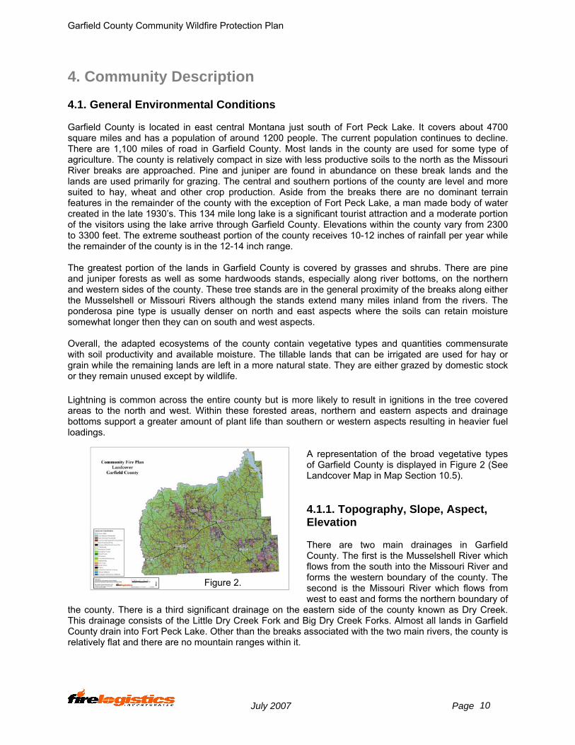
4. Community Description 4.1. General Environmental Conditions Garfield County is located in east central Montana just south of Fort Peck Lake. It covers about 4700 square miles and has a population of around 1200 people. The current population continues to decline. There are 1,100 miles of road in Garfield County. Most lands in the county are used for some type of agriculture. The county is relatively compact in size with less productive soils to the north as the Missouri River breaks are approached. Pine and juniper are found in abundance on these break lands and the lands are used primarily for grazing. The central and southern portions of the county are level and more suited to hay, wheat and other crop production. Aside from the breaks there are no dominant terrain features in the remainder of the county with the exception of Fort Peck Lake, a man made body of water created in the late 1930’s. This 134 mile long lake is a significant tourist attraction and a moderate portion of the visitors using the lake arrive through Garfield County. Elevations within the county vary from 2300 to 3300 feet. The extreme southeast portion of the county receives 10-12 inches of rainfall per year while the remainder of the county is in the 12-14 inch range. The greatest portion of the lands in Garfield County is covered by grasses and shrubs. There are pine and juniper forests as well as some hardwoods stands, especially along river bottoms, on the northern and western sides of the county. These tree stands are in the general proximity of the breaks along either the Musselshell or Missouri Rivers although the stands extend many miles inland from the rivers. The ponderosa pine type is usually denser on north and east aspects where the soils can retain moisture somewhat longer then they can on south and west aspects. Overall, the adapted ecosystems of the county contain vegetative types and quantities commensurate with soil productivity and available moisture. The tillable lands that can be irrigated are used for hay or grain while the remaining lands are left in a more natural state. They are either grazed by domestic stock or they remain unused except by wildlife. Lightning is common across the entire county but is more likely to result in ignitions in the tree covered areas to the north and west. Within these forested areas, northern and eastern aspects and drainage bottoms support a greater amount of plant life than southern or western aspects resulting in heavier fuel loadings.
A representation of the broad vegetative types of Garfield County is displayed in Figure 2 (See Landcover Map in Map Section 10.5). 4.1.1. Topography, Slope, Aspect, Elevation There are two main drainages in Garfield County. The first is the Musselshell River which flows from the south into the Missouri River and forms the western boundary of the county. The second is the Missouri River which flows from west to east and forms the northern boundary of
the county. There is a third significant drainage on the eastern side of the county known as Dry Creek. This drainage consists of the Little Dry Creek Fork and Big Dry Creek Forks. Almost all lands in Garfield County drain into Fort Peck Lake. Other than the breaks associated with the two main rivers, the county is relatively flat and there are no mountain ranges within it.
Figure 2.
July 2007 Page 10

Garfield County Community Wildfire Protection Plan
The dominant vegetative cover in Garfield County is rangeland. The area immediately south of Fort Peck Lake and just east of the Musselshell River is best described as moderately timbered. The vegetation cover changes to a completely open grass type near Dry Creek to the east with a gradual transition in between. The vegetative cover in the former area consists of Ponderosa Pine and juniper overstory with grass and other shrubs making up most of the understory. There are also significant areas of sage mixed in. The trees give way to more grasses and sage to the south and east. Agricultural crops are also found in the more productive and more tillable lands to the south. Aspect is the direction toward which a slope faces. Because of the topographic nature of Garfield County, the areas just east of the Musselshell have a high incidence of west facing aspect and the areas just south of Fort Peck Lake have a high incidence of north facing aspect. Because of the rugged nature of the breaks, however, all aspects are represented at one location or another to varying degrees. The remainder of the county is relatively level resulting in all aspects being more or less equally represented. 4.1.2. Meteorology, Climate, Precipitation and Fire Weather Weather directly affects fire behavior, with wind and low humidity values being the major influencing factors due to their ability to quickly dry fuels and allow fires to grow rapidly. Generally, steering winds at the surface and aloft over central Montana in the spring and summer prevail out of the south to west and are moderate to strong across open areas with lighter winds over rougher hilly or mountain areas. Surface winds vary depending on the method used for developing the winds, elevation, aspect and openness of the local terrain. Southwest and west facing slopes are more exposed to the prevailing winds and have drier fuels, which relates to increased fire behavior activity. Fires generally spread from southwest to northeast. Wind speeds are of great concern for fire fighters and strongly influence all fire activity. Winds are generally caused by one of four methods. The first method is pressure gradient winds. These winds are caused by winds trying to equalize pressure between high and low pressure systems. An example of this is a cold frontal passage accompanied by gusty winds. These winds are typical of open grassy areas found across large portions of Garfield County. A second method for generating winds is by diurnal heating and cooling of the land. These winds are typically found in mountain or hilly areas where daytime upslope and nighttime down slope winds occur. These winds are usually lighter than pressure gradient winds but can be over-ridden by strong pressure gradient winds. The third method of producing wind is by outflow from thunderstorm activity. These winds can be very erratic as well as very gusty and can challenge all wildland fire suppression efforts and lead to fire fighter safety concerns as well as the potential for large wildland fire growth. The fourth method is primarily a winter phenomena with strong to very strong lee slope winds. The normal summer weather pattern for central Montana can best be understood by looking at the larger weather pattern for the entire western United States. The Bermuda High located in the Caribbean and Gulf of Mexico makes its way across Texas and New Mexico by July and cuts off a supply of low-level moisture from the Gulf of Mexico to the plains of North America. This allows general thunderstorm activity to decrease across central Montana as the low level moisture diminishes. This allows the lower atmosphere to dry with a corresponding lowering of humidity values. This is timed with the development of a high-pressure system that sets up across Montana with subsidence within the high-pressure system that dries the atmosphere. This subsidence does two things; it brings very warm temperatures (95-110) to the area and it significantly lowers the relative humidity values. During this time overnight humidity recovery becomes poor allowing the drying of fuels of all size classes (1 hour, 10 hour, 100 hour, and 1000 hour plus time lag fuels) to continue through the nighttime hours. The 1-100 hours time lag fuels will show evidence of drying within 3-5 days. The 1000 hours fuels will take significantly longer to dry, usually in the 3-5 weeks range. The typical fire season in central Montana is from early spring into the fall or early winter or from March through November. Spring, before green-up, can be a time of large fire growth as dry residual winter cured fuels combined with gusty winds pose a threat of large fires. Moisture in the spring provides for fuel growth and is a time for prescribed fire activity. As the season turns to summer, the amount of moisture
July 2007 Page 11
Garfield County Community Wildfire Protection Plan
from thunderstorms taper off while grasses and shrubs begin to lose their live fuel moisture, down fuels begin to dry, and fire conditions normally peak by late August. As autumn approaches, temperatures generally begin to cool and killing frost begins to affect fuels. Dry cold frontal passages become common and can promote conditions of extreme fire behavior especially when accompanied by very strong winds. Late fall conditions of late October and November mark the transition into winter, but again, dry cold frontal passages at this time of year and the lack of snow pack can lead to conditions of rapid fire growth and high intensity fire behavior during wind events. Climatic seasonal changes can influence fire behavior as well. Winter months of December through February are generally non-fire months, but snow pack accumulations can be a key factor in potential fire activity for any given fire season. In the last half of the 20th century, spring seasons (April through June) were generally moist months with low fire frequencies. The ignitions that did occur resulted in mostly low intensity fires. Since 1988, the weather patterns have been changing to a warmer and dryer cycle resulting in extended fire seasons; spring months no longer can be counted on as a low fire period of the year. Long-term drought conditions have increased the fire complexity in central Montana and Garfield County and it is not unusual for significant pre green-up fires to occur in the early spring.
Moisture regimes in the spring and summer can be defined in terms of storm tracks, which typically move across the county from southwest to east. The storm track affecting the analysis area starts along the western or southern edges of Garfield County and tracks northeastward across the county before moving out farther onto the eastern plains of Montana. Significant moisture associated with these storm tracks will be higher in April and May and will trend downward in June with mainly dry thunderstorms expected in July and August. Thunderstorm activity is possible in September and early October but at a much-reduced rate compared to early spring. Winters have been mild for the past few years with a pronounced drought that affected large portions of the Northern Rockies. Winter and spring snow events have been fewer with less snow accumulating over the mountains with streams and rivers flowing at or near record low levels. In addition, subsurface moisture continued to be short helping to stress vegetation of all types. Bug kill has spread across large portions of the Northern Rockies and tree covered areas of Garfield County over the past few drought years providing standing dead fuels for potential large fires. The winter of 2005-2006 continued this trend with warmer than normal conditions along with drier than normal moisture however several spring storm systems in March and April 2006 have provided much needed widespread moisture across large portions of Montana. While this moisture has helped the agriculture community and helped replenish surface and subsurface moisture with near normal streams and reservoirs, the long-term drought continues to pose potential large fire problems in the larger fuel types. The higher elevations in the Absaroka Mountains of southern Montana and the Big and Little Snowy Mountains in Fergus County provide the orographic lifting that results thunderstorm formation when encountering ample low level moisture across central Montana grow to mature storms that move across Garfield County. Heavy lightning activity associated with these storms contributes to a significant number of fire starts along the storm’s path especially in late July and August across the Missouri Breaks across northern Garfield County. Dry lightning events increase during this period with these thunderstorms often producing strong down draft winds with little if any rain. These storms can be several miles wide at their bases with lightning expected anywhere within a 40-50 mile radius of the storms. A review of the fire history for Garfield County for the years 1982-2005 showed the following:
1 Average maximum temperature warmest in July and August. 2 Average wind speed was slightly higher in winter, early spring and late fall. During the summer
winds are moderate with the higher winds over open ground and generally from a westerly direction. Wind gusts during the summer were strongest from thunderstorm outflow winds or associated with frontal passages.
3 August is consistently the driest month with weather records showing poor nighttime relative humidity recovery. During the daylight hours the relative humidity begins to drop substantially beginning at 0900 and remains low until 2100. These lows bottom at the lower teens around 1700-2000. In reviewing the weather history, there are also days in August where relative
July 2007 Page 12

Garfield County Community Wildfire Protection Plan
humidity values remained low for consecutive multiple twenty-four hour periods. 4 Moisture events were lowest July through November from the statistics but caution should be
used for October and November due to limited sampling. Relative humidity values will be higher for multiple days after wetting moisture of 0.10 inches to 0.50 inches.
5 Continued drought conditions have begun to modify but have stressed large fuels while bug infestations are providing more standing dead fuels.
6 Drought stressed conifer stands contributed to large fire spread, where high fire intensities did not allow for aggressive initial attack or fire suppression with ground forces due to safety concerns.
7 Lightning occurrence usually begins in April with the heaviest occurrence in May and June. Dry Lightning is most prevalent July and August.
Tabular conditions of temperature, humidity, precipitation and winds are listed below. Caution should be used with the October and November data as the sample period is limited. These numbers listed below are more typical of open grassy areas where warmer temperatures, lower humidity values and stronger winds can be expected.
Garfield County Years
1982-2005
Temp (F) Mar Apr May Jun Jul Aug Sep Oct Nov Max 63.9 75.0 82.7 90.9 95.1 95.3 88.9 77.6 61.6 Avg 42.1 52.8 62.2 71.2 80.4 80.2 67.5 54.3 38.8 Min 15.7 28.8 38.6 50.8 60.4 58.5 42.5 27.6 15.8
RH (%) Mar Apr May Jun Jul Aug Sep Oct Nov Max 91.2 90.7 92.4 90.1 76.8 76 85.5 94.1 91.8 Avg 48.8 42.1 42.9 43.2 33.6 31.9 37.6 43.8 52.5 Min 21.7 17.3 18.0 19.9 14.9 13.8 14.1 17.1 24.1
Pcpn (Inches) Mar Apr May Jun Jul Aug Sep Oct Nov Max 0.78 2.38 4.05 5.17 3.92 2.63 4.76 1.41 0.78 Avg 0.42 1.08 2.24 2.44 1.55 1.08 0.94 0.63 0.29 Min 0.07 0.29 0.43 0.55 0.00 0.03 0.01 0.03 0.00
Wind (MPH) Mar Apr May Jun Jul Aug Sep Oct Nov Max 19.9 21.4 20.2 18.5 17.6 18.8 18.3 18.9 18.7 Avg 8.8 9.3 9.0 8.6 7.9 8.0 8.5 8.7 8.5 Min 2.5 3.2 2.7 2.6 2.9 2.7 3.0 2.4 2.0
Figure 3 depicts the average annual precipitation for Garfield County during the years of 1961 through 1990.
Figure 3
July 2007 Page 13
Garfield County Community Wildfire Protection Plan
4.2. Population, Demographics Population and demographics information was derived from the 2000 Census. The population for Garfield County was 1,279. The area in square miles was given as 4,848. The Census showed 532 households with a density of <1 housing units per square mile and a population density of <1 per square mile. The median age of county residents was 42. The median family income was $31,111 with 16.70 % of families below the poverty line. Jordan is the only town listed in Garfield County and its population is listed at less than 500 people. 4.3. Infrastructure: Roads, Driveways, Utilities, Communication, Water Supply, Schools, and Hospitals US Highway 200, running east and west through the county, and US Highway 59, running from Jordan southeast toward Miles City, are the only major roadways that serve Garfield County. There are no railroads serving Garfield County. The Missouri River is adjacent to the northern boundary of the county and the Musselshell River is adjacent to the western boundary of the county. There is no bus service to Jordan. There are a few operating oil wells in the extreme southeast corner of the county as well as several inactive ones in what is known as the East Dome Cat Creek Oil Field. Even though there are power generation facilities located at Fort Peck Dam just north of Garfield County, the county receives its power from other sources. This power is distributed in Garfield County by McCone Electric. Many private ranches and developments are provided access utilizing graveled or un-surfaced roads. The un-surfaced roads are difficult to travel in wet weather and may become impassable. Utilities are provided via overhead transmission and distribution lines. The county has one public airport with a 4,300 foot strip located at Jordan and another landing strip in Sand Springs. Electrical service to Jordan is provided by McCone Electric. Telephone service is provided by Mid-Rivers Telephone Cooperative. Verizon and Alltel provide cellular phone service and depending on one’s specific location, coverage can be achieved throughout the county. Municipal water service is provided by the Town of Jordan, otherwise water is provided by wells in the rest of the county. Propane tanks are located throughout Garfield County at ranch and home sites. 4.4. Emergency Services Emergency services within Garfield County include fire protection, emergency medical services including ambulance transportation, law enforcement, and emergency preparedness. 4.4.1. Fire Protection Structure fire protection is provided to the Town of Jordan, by the Jordan Fire Department. Jordan Fire Department provides mutual resources to Garfield County Fire Department. There is no formal written mutual aid agreement between the Town of Jordan Fire Department and Garfield County Fire Department.
Wildland fire protection is provided by the Garfield County Fire Department under the direction of the county fire warden with various fire suppression resources throughout the County under the Garfield County Co-Op plan (See Fire Resource Locations in Map Section 10.5).
July 2007 Page 14

Garfield County Community Wildfire Protection Plan
Garfield County is within the Eastern Land Office of the Montana DNRC’s geographic area and is a “coop” county. This provides additional resources such as air tankers from Billings and Rapid City, helicopter from Miles City, single engine air tankers from Miles City and crews and overhead through the Eastern Land Office. Single engine air tankers (SEATs) can load retardant at the Jordan Airport SEAT Base. During the fire season these resources may be committed to other incidents and may not be available to Garfield County during an wildland fire. Garfield County Disaster Emergency Services has agreements with surrounding counties and these have recently been updated. 4.4.1.1. Fire Engine Pump/Draft Source Sites Water supply sources for wildland fire protection and structural fire protection throughout Garfield County are relatively scarce. They include stock ponds, holes in creeks, the Musselshell River and Fort Peck Lake. Access to Fort Peck Lake through the CMR is further complicated by Fish and Wildlife Service policy concerning road closures, however, access to closed roads for suppression actions can be approved on a case by case basis by the Refuge Manager. Due to the long-term drought in Garfield County, most ranchers are concerned about the drawdown of their stock ponds for fire protection. An attempt to replace any water used from these facilities is made by the County Fire Chief. In most cases water needs to be brought to the fire, through fire apparatus such as water tenders. 4.4.1.2. Training, Certification, and Qualification All incidents require different skill levels of incident management personnel. To assist in assigning appropriate incident commanders to wildland fire incidents, an incident analysis can be used as a guide to identify and mitigate certain complexity and safety issues by selecting a different strategy, tactic, or requiring higher qualifications of incident command personnel. Certain assumptions are made in this analysis:
As an incident becomes more complex, the need for an incident management team or organization increases.
To facilitate assembling an efficient and effective organization, key managers should be involved during the early stages of the complexity analysis; this should include federal, state, and local officials.
The analysis is not a cure-all for the decision process; local fire history, current fire conditions, and management experience must be considered.
All wildland fires, regardless of size, should have an assigned Incident Commander (IC). The training, certification and qualifications of the Incident Commander (IC) vary by the type of fire. General guidance is: Type 5 Incident
Resources required typically vary from two to six firefighters The incident is generally contained within the first burning period and often within a few hours
after resources arrive on scene. Type 4 Incident
Command staff and general staff functions are not activated. Resources vary from a single resource to several resources. The incident is usually limited to one operational period in the control phase. No written incident action plan (IAP) is required. However a documented operational briefing will
be completed for all incoming resources (See Briefing Checklist in Resources Section). Type 3 Incident
In-briefings and out-briefings are more formal.
July 2007 Page 15

Garfield County Community Wildfire Protection Plan
Some or all of the command and general staff positions may be activated, usually at the division/group supervisor and/or unit leader level.
Type 3 organizations manage initial attack fires with a significant number of resources, an extended attack fire until containment/control is achieved, or an escaped fire until a Type 1 or Type 2 team assumes command.
Resources vary from several resources to several task forces or strike teams. The incident may be divided into divisions. The incident may involve multiple operational periods prior to control, which may require a
written IAP. A documented operational briefing will be completed for all incoming resources and before each
operational period (See Briefing Checklist in Resources Section). Staging areas or an incident base may be used.
By completing an Incident Complexity Analysis, the County Fire Warden can assess the hazards and complexities of a wildland fire incident and determine the level of qualifications the incident management team may require (See Incident Complexity Analysis in the Resources Section). Required training, experience and prerequisites for various wildland fire management positions are contained in PMS 310-1 (Wildland and Prescribed Fire Qualification System Guide). PMS 310-1 has been adopted by the Northern Rockies Coordinating Group (NRCG) and, consequently, applies to all wildland fire fighting personnel in the state of Montana, including Garfield County, for mobilization outside of the county. Within the County, local standards would apply. Experience gained in mobilizing to wildland fires within the county and throughout east central Montana and the Northern Rockies has allowed Garfield County personnel to acquire increased training and fire qualifications. Those experiences have allowed Garfield County fire personnel to more efficiently perform and manage fire operations within the county. 4.4.2. Law Enforcement Law enforcement and evacuation services are provided by the Garfield County Sheriff’s Office. 4.4.3. Emergency Medical Services The Garfield County Volunteer Ambulance, with ambulances located in Jordan, provides Garfield County ambulances and ambulance transport services. 4.4.4. Emergency Management Overall County emergency preparedness and planning comes under direction of the office of the Garfield County Disaster and Emergency Services. 4.5. Insurance Ratings The insurance premiums that residential and commercial customers pay are based on a rating system established by the Insurance Services Office (ISO). In its evaluation of a community, ISO considers the water system and the fire protection provided by the fire department. The relative weights of the components are: Water Supply - 50 Fire Department - 40 Fire Dispatch - 10 The rating system produces ten different Public Protection Classifications, with Class 1 receiving the most
July 2007 Page 16

Garfield County Community Wildfire Protection Plan
insurance rate recognition and Class 10 receiving no recognition.5 It is important to note that some insurance companies will not insure structures that are outside of the 5 road miles from a fire station. The Jordan Fire Department has an Insurance Services Office insurance rating of Class 7. Garfield County, not having a structural fire department, has an ISO Rating of Class 10. Improvements to the water delivery system, dispatch and to the fire department could improve the ISO rating, which would result in some annual insurance premium savings to the city and county’s customers. 4.6. Land Use/Development Trends The majority of lands in Garfield County are dedicated to ranching and agriculture. There is an increasing demand for recreation oriented land use primarily centered on or around Fort Peck Lake and in some other county lands as well. This demand will most likely grow over the coming years. 4.7. Air Quality The State of Montana’s air quality is managed by the Montana State Airshed Group through the Department of Environmental Quality. Golden Valley County is located in Airshed 9 (See Figure 4).
Generally, open burning is permitted year around in the eastern Montana opening burning zone (Airshed 9 and 10), during December, January, and February the DEQ needs to be notified by telephone of agricultural or prescribed wildland open burning. In most cases this approval can be obtained for any proposed open burning in the eastern Montana zone because of good smoke dispersal and the lack of significant air quality issues such as the valley inversions experienced in western Montana. Figure 4 4.8 Summary
The impacts that the elements of the community have on the wildland fire program and the delivery of wildland fire fighting services in Garfield County are summarized in Table 4.8.1.
5 Fire Protection Handbook, NFPA 1997
July 2007 Page 17
Garfield County Community Wildfire Protection Plan
Table 4.8.1
Element Summary of Impact on Garfield County’s Wildland Fire Program
Topography, Slope, Aspect, Elevation
Accessibility
Increased rates of spread
Meteorology, Climate, Precipitation and Fire Weather
Accessibility of water
Increased number of high fire danger days
Increased flammability of fuels
Population, Demographics Potential reduction in the availability of volunteers
Potential reduction in the skill and experience of volunteers
Need for increased recruitment and training
Need for fire protection planning
Infrastructure Reduced accessibility
Fire Protection Lack of structure fire protection capability in the county
New RFD’s need to be formed along with new subdivisions
Implementation of local government fire protection services
Increased damage from structure fires
High cost wildland urban interface fires
Risk transfer to Garfield County Fire
Fire Engine Pump/Draft Source Sites
Natural terrain limits access and accessibility to reliable water sources
Training, Certification, and Qualification
Availability of personnel
Financial Constraints
Mitigate potential liability
Law Enforcement Capacity to deliver evacuation services, security
Operational Cooperation
Insurance Ratings Predictor of service capability
Increase or decrease in insurance premiums paid
Land Use/Development Trends Changing fire protection risk profiles
Risk transfer to Garfield County Fire
Air Quality Ability to conduct prescribed burns
July 2007 Page 18

Garfield County Community Wildfire Protection Plan
5. Current Fire Environment The following narratives describe the current fire environment in Garfield County. These perspectives are a result of an on the ground tour conducted by Garfield County fire authorities and Fire Logistics personnel in October of 2005 and May of 2006. 5.1. Wildfire Problem Definition As stated in Chapter 4, Garfield County has limited areas of forested land in the western, northwestern and northern portions of the county. Almost all of these are the ponderosa pine ecosystems typical of eastern Montana with some cottonwood and mixed hardwood types in the river bottoms. As will be discussed in the next section, this ponderosa pine ecosystem is prone to having a frequent wildland fire interval. The impacts of those frequent fires can be quite variable depending on the values at risk. The emergence of subdivisions within the large open blocks of land presents the probability of material losses to man made improvements as well as possible threats to the occupants of those new developments. Currently, Garfield County Fire Department has fire protection responsibilities for state, except for state lands within the boundaries of the CMR, and private wildlands within the county. Technically, BLM and F&WS have protection responsibilities for their respective lands within the county. In reality, the county is often the first on the scene in both of these federal areas because the fire engines located in the rural areas of the county. Improved communications between the county fire fighters and the federal agencies can improve the response and response time to wildland fires throughout the county. The county fire department is also the structure protection organization for the county. There are at least five major challenges facing the county fire protection organization in the performance of their duties: Water Supply – Garfield County is a very arid county with little natural water aside from the Musselshell River and Fort Peck Lake. Access – The terrain of Garfield County is such that cross-country travel by engines is difficult and much of the area would be considered inaccessible to vehicles other than dozers or all terrain vehicles. Subdivision Development – Garfield County has adopted subdivision regulations for a developer to meet when establishing a subdivision. There will be continued pressure to subdivide large land blocks within Garfield County for a public eager to own a piece of Montana. Development in the wildland urban interface will create many problems for the county fire department in the future, most notably protecting those people in a large wildland urban interface fire event. Travel Times – Garfield County is a very large county and the travel times required to respond to wildland fires is often an hour or more, even with fire engines stationed throughout the county. Multiple Ignitions – Lightning is the main ignition source for wildland fires with the county and thunderstorms normally start multiple fires per episode. Multiple fire starts challenge the capability of any fire department. Future Recruitment – While the county currently has an outstanding leader managing the fire program this situation will not last forever. In a county with a diminishing population it will be increasingly difficult to find available, motivated and physically capable individuals to fill the leadership and subordinate positions in the fire organization. The County Fire Chief has done an excellent job of placing the 16 slip-on units within Garfield County so that a wildland engine is generally located throughout the areas of the county where fire occurrence is the highest and where there is a willing host who will make a commitment to attending required training and respond to wildland fires when needed.
July 2007 Page 19

Garfield County Community Wildfire Protection Plan
No written agreements have been developed between Garfield County and the two federal agencies with which they work. 5.2. Wildland/Urban Interface The wildland/urban interface is defined as the line, area, or zone where structures and other human development meet or intermingle with undeveloped wildland or vegetative fuels.6 Similar terms are wildland/residential interface and wildland/urban intermix. During the past several fire seasons of 2000, 2003 and 2006, it has become evident that wildland/urban interface fire losses have increased throughout the Western United States. The expectation under the Federal Fire Policy is “that losses will increase in the future.”7 According to research conducted by Volker C. Radeloff, assistant professor at the University of Wisconsin at Madison, of the 13 million homes constructed in the 1990’s, 69 % or 9 million homes were constructed in the wildland urban interface.8 From a fire fighter’s perspective there are nine Wildland Urban Interface "Watchout" Situations that are significant to the safety of wildland fire fighters:
Wooden construction and wood shake roofs Poor access and narrow congested one-way roads Inadequate water supply Natural fuels closer than 30 feet to structures Extreme fire behavior Strong winds Need to evacuate the public Structures located in chimneys, box or narrow canyons, or on steep slopes in flashy fuels Inadequate bridge load limits
Jordan and Mosby are listed in the Federal Register as “Communities at Risk” from wildland fire. The Bureau of Land Management assessed the wildland urban interface areas within the Miles City District in the early 1980’s in Garfield County (See Figure 5). Wildland urban interface areas identified were the North Breaks Subdivision and the Musselshell Breaks Subdivision. There are several additional areas of wildland -urban interface within the county, which have been identified during this planning process (See Planning Area Map in Map Section 10.5). Areas of wildland-urban interface in Garfield County include:
East and West Fort Billings Subdivision Musselshell Breaks (Angel Hill) Subdivision Hell Creek Recreation Area Jordan Mosby Cohagen Sand Springs Brussett All of Garfield County can be considered wildland urban
interface due to extended drought
The development of portions of Garfield County into residential lots of varying sizes is contributing to the wildland/urban interface fire problem for the fire protection agencies in Garfield County. This leads to several complex problems, which need to be addressed in the Fire Plan:
Figure 5
Access
6 Ibid. 7 Federal Fire Policy, 2001 8 Pomfret, John; As Houses Rise in the Wild, So Do Fire Concerns; Washington Post; 2006
July 2007 Page 20

Garfield County Community Wildfire Protection Plan
Asset Protection Zones Water Supply Building Construction Requirements Fuel Reduction On All Ownerships Kinds And Types Of Fire Apparatus Required For Fire Protection Structural Fire Protection For Structures Outside Organized Fire Protection Jurisdictions
In addition to the fire losses increasing from wildland urban interface fires, the costs of fire suppression have continued to increase as well. Fire costs are passed along to the community, through all levels of government and eventually to the general population. Local government has a legislative responsibility to develop and enforce public policy that mitigates or eliminates the problems of the wildland urban interface or modifies the behavior of those who elect to build a home in wildland urban interface areas just at they do for flooding or other potential hazardous natural events.9 5.3. Structure Fire Problem Definition The best way to quantify the structure fire problem in the Garfield County is to conduct an occupancy risk assessment, which evaluates the severity of a specific structure in relation to the fire districts ability to handle the types and severity of emergencies with that structure.10 Risk categories used in the Self-Assessment Manual developed by the International Commission on Fire Accreditation are: 11
Category Description
Maximum/Worst Risk
Occupancies classified as maximum risk will be of substantial size and contain a concentration of properties, which present a very high risk of life loss, loss of economic value to the community or large loss damage to property in the event of a fire. These risks impact the need for the fire department to have multiple alarm capability and have an adequate assessment of their ability to concentrate resources.
High Hazard/Key Risk
Built-up areas of substantial size with a concentration of property presenting a substantial risk of life loss, severe financial impact on the community or unusual potential damage to property in the event of fire.
Moderate/Typical Risk
Built up areas of average size, where the risk of life loss or damage to the property in the event of a fire in a single occupancy is usually limited to the occupants. In certain areas, such as small apartment complexes, the risk of death or injury may be relatively high. The moderate/typical risks are often the greatest factor in determining fire station locations and staffing due to the frequency of emergencies in this category. To assure an equitable response and to provide adequate initial attack/rescue capability to the majority of incidents, the typical risk is often used in determining needed resources.
Garfield County has buildings and occupancies in all three categories with the majority being in the moderate/typical risk category.
9 Gilbert, Gary; Focusing Local Government; American Perspectives on the Wildland/Urban Interface, 2005 10 Fire and Emergency Service Self-Assessment Manual, Commission on Fire Accreditation International, 6th Ed. 11 ibid.
July 2007 Page 21

Garfield County Community Wildfire Protection Plan
Figure 6. Maximum/Worst Risk
Figure 7. High Hazard/Key Risk
Figure 8. Moderate Hazard/Typical Risk
July 2007 Page 22

Garfield County Community Wildfire Protection Plan
The Commission on Fire Accreditation International, Fire and Emergency Service Self-Assessment Manual outlines the needed staffing levels for incidents occurring in the different types of risk occupancies, which are detailed in the following table.12
Task Maximum/ Worst Risk
High Risk
Moderate Risk
Low Risk
Attack Line Search and Rescue Ventilation Back-up-Line Pump Operator Water Supply Utilities Support Command/Safety Forcible Entry Accountability Salvage Overhaul Communication Chief’s Aid Operations Officer Administration Logistics Planning Staging Rehabilitation Sector Officers High-Rise Evacuation Stairwell Support Relief Investigation
4 (16-18*) 4 4 2 1 1 1 2 * 1 * *
1* 1 1 1 *
1 1-4*
10-30* 10* * *
4 2 2 3 1 1 1 2
1
1* 1*
2 2 2 3 1 1 1 1
2
1
1#
TOTALS 25-65* 17 13 3-4
Staffing Resources for Risk Type Occupancies. # Can often be handled by the first due officer. * At maximum and high-risk fires, additional fire fighting personnel are needed
Structural fire suppression whether in a rural environment or in one of our cities requires the accomplishment of the above listed tasks, many of which must occur almost simultaneously to ensure effective and safe operations at the incident scene. To ensure an effective fire fighting force on the scene of significant fires in these kinds of risks, current staffing levels need to be augmented with paid-call fire fighters, volunteers and mutual aid from other fire departments. A principal difference between rural fire departments and their municipal counterparts is that the rural departments must typically solve the water supply issues in addition to fighting the fire. Typical rural departments incorporate water tenders, portable tanks, draft points, accessible water supplies, and etc. into their fire protection strategies for rural areas of Garfield County. To be minimally effective in controlling a structure fire, the initial responding apparatus should reach the scene of the fire before “flashover” occurs.13 The time from ignition to flashover varies based on the materials involved in the fire, but generally occurs somewhere between 4 and 10 minutes. The following chart illustrates the relationship between the response time or reflex time and flashover and/or critical brain damage in an EMS incident.
12 ibid. 13 Evaluation & Planning of Public Fire Protection, John Granito
July 2007 Page 23

Garfield County Community Wildfire Protection Plan
The Significance of Flashover
Pre-Flashover Post-Flashover
Limited to one room May spread beyond the room of origin
Requires smaller attack streams Requires more larger attack lines
Search & Rescue is easier Search and Rescue is difficult
Initial assignment can handle Requires additional fire companies For municipal departments in small and medium sized cities, all of the first alarm apparatus will not arrive at the fire scene simultaneously. In a department like Jordan Fire, the volunteer fire fighters are paged, respond to the fire station, don personnel protective equipment, and respond to the incident. Policy makers in the city and the county need to be concerned with what level of service is provided to the community, i.e., the number of personnel and apparatus that can arrive at the fire scene within a stipulated time frame and a percent of time that it will occur. Sample performance statement for a maximum risk structure fire might be:
The first unit shall arrive within 6 minutes total reflex time, for 90% of all requests for emergency service. The second-due engine and first-due truck company shall arrive within 10 minutes total reflex time, for 90% of all requests for emergency service. Remaining units, including battalion chiefs, shall arrive within 13 minutes total reflex time, for 90% of all requests for emergency service. The rescue company shall arrive within 15 minutes total reflex time, for 90% of all requests for emergency service.
A low risk structure fire performance measure might be:
July 2007 Page 24
Garfield County Community Wildfire Protection Plan
The first engine shall arrive within 6 minutes total reflex time, for 90% of all requests for emergency service. The second-due engine shall arrive within 10 minutes total reflex time, for 90% of all requests for emergency service. Remaining units, including battalion chiefs, shall arrive within 15 minutes total reflex time, for 90% of all requests for emergency service.
Clearly levels of service need to be established by the community for each of the services provided by the typical fire department to include:
□ Structure fires □ Wildland fires □ Hazardous Materials □ Emergency Medical Services □ Special Operations, including confined space and trench rescue □ Auto Extrication
The fire departments will then be able to measure how successful they are in delivering quality services to their customers. Other tools that can be used to measure the effectiveness of fire service organizations are:
NFPA 1720 - Standard for the Organization and Deployment of Fire Suppression Operations, Emergency Medical Operations, and Special Operations to the Public by Volunteer Fire Departments
Insurance Services Office – Fire Suppression Rating Schedule Neither of the fire service organizations in Garfield County have NFPA 1720 plans. There is no structure fire protection outside the city limits of the incorporated cities and towns in Garfield County. If a structure fire were to occur and Garfield County Fire requested mutual aid from one of the incorporated cities or towns to fight the structure fire while Garfield County’s Fire Department’s responsibility is to keep the fire from spreading to the wildlands. The issue of no entity providing structural fire service to Garfield County places the Garfield County Fire Department in a very tenuous position of responding to a structure fire with what looks like a fire truck, but not being able to fight the fire due to pump capacity, training, equipment, etc. The issue of structure fire protection in Garfield County should be addressed by the Garfield County Commission. 5.4. Local Fire Ecology The prevalent timber type in Garfield County is ponderosa pine. This type is a fire adapted tree species that has developed natural mechanisms to cope with frequent fire. It has a thick corky bark that insulates the tree’s cambium from heat generated by wildland fires. The cambium is the living layer of cells between the bark and the woody portion of the tree stem and is responsible for the growth of both new wood and new bark. Ponderosa pine can be found on hot dry sites such as those found in Garfield County. Because of the frequency of lightning storms in the county, it is estimated that fire burned in and under most of the natural pine stands at a 10-20 year interval and less than that in some areas. Because of this frequency fuel loadings were traditionally low in the stands as dead branch wood and needle litter were consumed during these fire events. The fires also tended to thin out patches of heavy regeneration that resulted from good cone crop years and favorable moisture conditions. The fires kept the density of trees lower by selectively killing some of the thinly barked seedlings and smaller individual trees. The trees that did survive had a greater supply of nutrients and water to nourish them and were stronger and healthier. In the absence of the heavy fuel loadings, periodic low intensity fires would have had no significant impacts on the older trees that remained. Wildland fire is an essential, natural process that has helped shape our wildland areas for thousands of years and is important to the survival of many plants and animals. With the advent of fire protection, and changes occurring in other cultural practices such as grazing and farming, however, the situation has changed considerably. The natural litter occurring from the trees in these stands has accumulated for
July 2007 Page 25

Garfield County Community Wildfire Protection Plan
decades. In most areas there are many more trees per acre then there would have been historically. There are also more situations where continuous fuel exists from the ground to the crowns of mature trees (ladder fuels). This results when too many seedlings survive and, because of intense competition for water and nutrients, form overcrowded pockets of spindly trees. These trees will survive to intermediate heights with many of them bent or broken by snow loads, see Figure 9.
Along with the forested lands, there is an increasing threat to firefighters, the public and the improvements on private land from rangeland fires. These lands are typified by light flashy fuels which are capable of producing tremendous rates of spread, especially under windy conditions. The annual accumulation of grasses and forbs contributes to this phenomenon and the results, at best, will be the loss of fences, winter forage and possibly livestock. Today, when a wildland fire occurs it is much more likely to have greater negative consequence. The higher fire intensity caused by a greater amount of fuel, results in an increased amount of heat. This increased heat can have adverse
effects on the soil and, subsequently, the productivity of the site. Higher intensity fires are also more difficult to keep away from improvements that landowners and firefighters wish to protect. Most importantly, they increase the risk to firefighters.
Figure 9
Another phenomenon that has become evident the past few years is that the cumulative drought has changed the effects of fire in the pine stands. They have gone from one of a “non-lethal” nature to one of vast areas of “lethal” or stand replacement fire. Fires are killing the majority of the mature trees under these conditions whereas in the past only a small percentage would have succumbed. 5.5. Hazardous Fuels As displayed in the Land Cover Map, the continuity of heavy fuels, i.e. ponderosa pine, is relatively consolidated in Garfield County. In the north and west portions of the county there are areas of continuous pine type covering several thousand acres in size. These are the areas that have the greatest potential for supporting large intense fires. Fires may be terrain driven, (plume dominated) or wind driven in this fuel type. This is also the ecosystem type most attractive to developers for the placement of subdivisions. Areas of sage and brush species also have potential for large intense fires but they are less likely except under wind driven conditions. There are many thousands of acres of this fuel type in the county. The most common fuel type is grassland. Fires will normally be of a lower intensity level in this type and will be easier to control. In addition, fires are less likely to start from lightning in this ecosystem. 5.5.1. Fire Regime Condition Class Fire has always been a part of the wildland environment, changing and shaping the structure and composition of vegetation in the area. The five natural (historical) fire regimes are classified based on average number of years between fires (fire frequency) combined with the severity (amount of replacement) of the fire on the dominant overstory vegetation. These five regimes include: I – 0-35 year frequency and low (surface fires most common) to mixed severity (less than 75% of the dominant overstory vegetation replaced); II – 0-35 year frequency and high (stand replacement) severity (greater than 75% of the dominant overstory vegetation replaced);
July 2007 Page 26
Garfield County Community Wildfire Protection Plan
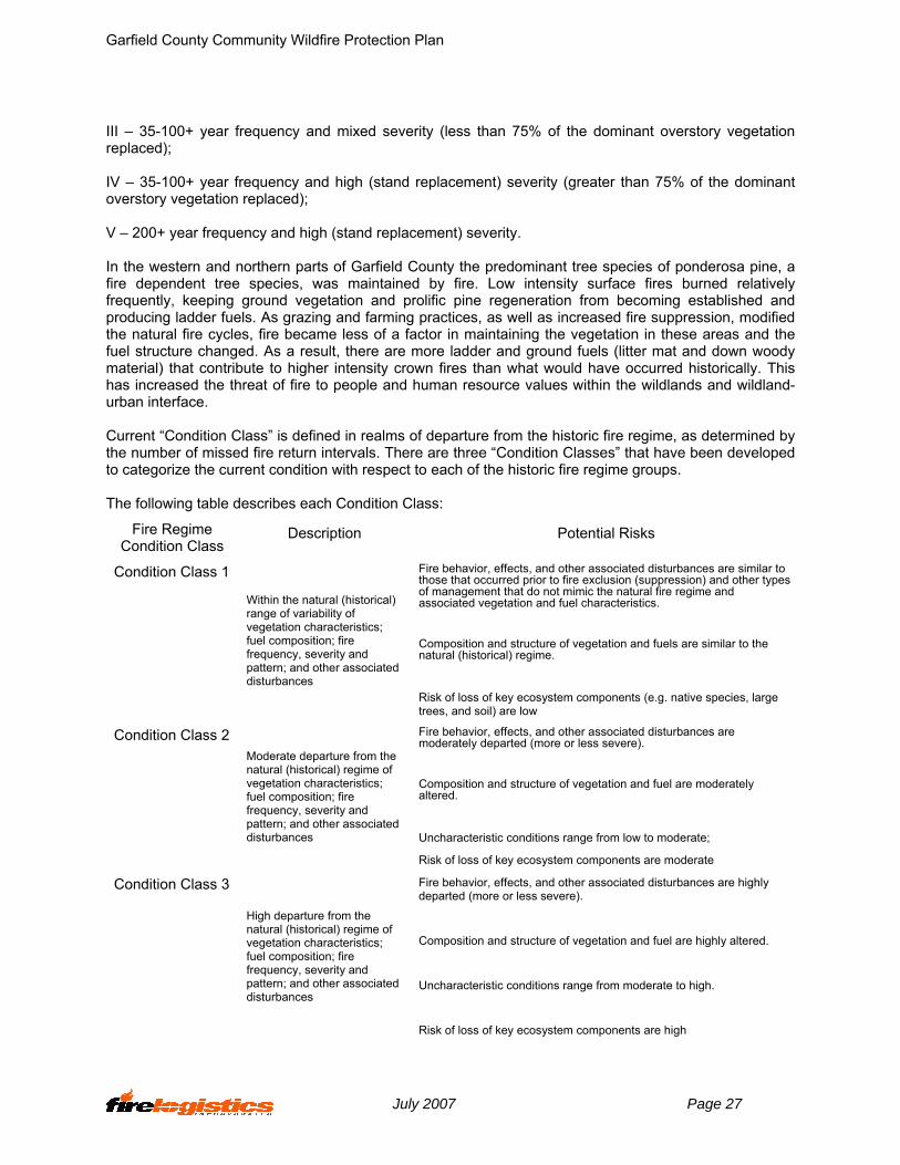
III – 35-100+ year frequency and mixed severity (less than 75% of the dominant overstory vegetation replaced); IV – 35-100+ year frequency and high (stand replacement) severity (greater than 75% of the dominant overstory vegetation replaced); V – 200+ year frequency and high (stand replacement) severity. In the western and northern parts of Garfield County the predominant tree species of ponderosa pine, a fire dependent tree species, was maintained by fire. Low intensity surface fires burned relatively frequently, keeping ground vegetation and prolific pine regeneration from becoming established and producing ladder fuels. As grazing and farming practices, as well as increased fire suppression, modified the natural fire cycles, fire became less of a factor in maintaining the vegetation in these areas and the fuel structure changed. As a result, there are more ladder and ground fuels (litter mat and down woody material) that contribute to higher intensity crown fires than what would have occurred historically. This has increased the threat of fire to people and human resource values within the wildlands and wildland-urban interface. Current “Condition Class” is defined in realms of departure from the historic fire regime, as determined by the number of missed fire return intervals. There are three “Condition Classes” that have been developed to categorize the current condition with respect to each of the historic fire regime groups. The following table describes each Condition Class:
Fire Regime Condition Class
Description Potential Risks
Condition Class 1 Within the natural (historical) range of variability of vegetation characteristics; fuel composition; fire frequency, severity and pattern; and other associated disturbances
Fire behavior, effects, and other associated disturbances are similar to those that occurred prior to fire exclusion (suppression) and other types of management that do not mimic the natural fire regime and associated vegetation and fuel characteristics.
Composition and structure of vegetation and fuels are similar to the natural (historical) regime.
Risk of loss of key ecosystem components (e.g. native species, large trees, and soil) are low
Condition Class 2 Moderate departure from the natural (historical) regime of vegetation characteristics; fuel composition; fire frequency, severity and pattern; and other associated disturbances
Fire behavior, effects, and other associated disturbances are moderately departed (more or less severe).
Composition and structure of vegetation and fuel are moderately altered.
Uncharacteristic conditions range from low to moderate;
Risk of loss of key ecosystem components are moderate Condition Class 3
High departure from the natural (historical) regime of vegetation characteristics; fuel composition; fire frequency, severity and pattern; and other associated disturbances
Fire behavior, effects, and other associated disturbances are highly departed (more or less severe).
Composition and structure of vegetation and fuel are highly altered.
Uncharacteristic conditions range from moderate to high.
Risk of loss of key ecosystem components are high
July 2007 Page 27

Garfield County Community Wildfire Protection Plan
5.5.2. Fire Breaks Since Garfield County is primarily an agricultural based county there are many land use activities that break up the continuity of the fuel types, particularly in the sage and grassland types. Cropland, grazed land and roads all contribute to interrupting continuous fuel beds thus giving fire fighters an opportunity to safely take effective action on wildland fires under less than severe conditions. The Musselshell River, Fort Peck Lake and the two forks of Dry Creek also provide natural fuel barriers within or adjacent to the county. There are also areas of open rock and clay bluffs that can prove to be effective barriers to the spread of wildland fire. 5.6. Fire History Almost all fires experienced in Garfield County are the result of lightning fires resulting from thunderstorms. These starts usually occur in the ponderosa pine forested areas and are relatively fast spreading in the grass and needle cast under story. They are also relatively easy to control unless the area is experiencing the cumulative effects of drought and/or when high winds move the fire rapidly through the prevalent fuel type. Even under more normal climatic conditions, fire can be expected to be a
problem when located in an area where the topographic or fuel conditions are conducive to the fire getting into the crowns of the trees and/or when access is limited The current long-term drought has made control more difficult in recent years. During July of 2006, some 125,000 acres burned in and around the CMR within Garfield County. In an average year there are approximately 80 fire starts, which burn a total area of 3000-8000 acres. In addition to the 2006 activity, there have been several other large fires in the county over the last ten years. Significant fires in the past include the Missouri Breaks
Complex and the Blue Pulaski Fire in 2003, and the Garfield Fire in 1996. These fires occurred on the types of days described in Section 4.1.2 (See Figure 10 and Fire History Map in Map Section 10.5).
Figure 10.
The current performance of wildland fire protection personnel in Garfield County is excellent considering the size of the county and the travel times required to respond, the access limitations, the frequency of wildland fires and the challenges of keeping local firefighters motivated and qualified in a county with such a small population. In addition, the overall lack of a water supply in many areas within the county significantly adds to the difficulty of conducting an effective suppression effort on wildland fires. On a severe burning day with extreme fire danger and multiple new ignitions it is probable that the supervisory capability and the county resource availability will be exceeded. Mutual assistance agreements with the State of Montana, BLM and the FWS and adjacent counties are imperative at a time like this to insure losses are kept to a minimum. Unfortunately, it is likely that local cooperators will have fire problems of their own under these conditions and rapid mobilization and deployment of resources from outside the area will be needed as occurred in July of 2006. 5.7. Expected Fire Behavior Fire behavior describes the way fires ignite and spread. Topography, fuel conditions, and weather all
July 2007 Page 28

Garfield County Community Wildfire Protection Plan
influence fire behavior and how wildland fires burn in Garfield County. Fuel is the only factor influencing fire behavior that people have the ability to manage. The following fire behavior assessment shows fire intensities and fire spread rates in different fuel types/models that are found in Garfield County. It is important to understand this information to determine what areas contribute to the fire problem in the county. The following fuel types/models were used for analyzing potential fire behavior: Fuel Type/Model 1: Grass that dominated by short grass where very little shrubs or timber is present over less than ⅓rd of the area. The fine, porous, and continuous fuels that have cured or are nearly cured govern fire spread. Fuel Model 2: Grass with open timber overstory that cover ⅓rd to ⅔rd of the area. This model represents the open grass and ponderosa pine and harvested areas where an overstory of timber remains. Fire spread is primarily by a surface fire through the curing or dead grasses with the litter and dead down wood from the open shrub or timber overstory contributing to fire intensity. This fuel model also includes scattered sagebrush within grasslands without ponderosa pine overstory. Fuel Model 6: Shrubs are older and require moderate winds for fire spread, but can be extremely flammable. Fire will fall to ground at low wind speeds. This fuel model includes sage and pinion juniper shrub lands. Under drought conditions, live fuel moisture is less than normal, causing shrubs to be more flammable. Fuel Model 9: Long-needle ponderosa pine stands with forest floor litter fall into this model. Fires in this fuel model run through the surface litter than in FM 8 and have longer flame lengths. Concentrations of dead-down woody material will contribute to possible torching out of trees, spotting, and crowning. Fuel Model 10: This model is represented by the older mature timber stands that have large fuel loads of dead material on the forest floor. This would include areas that are insect and disease ridden, wind-thrown stands, and over mature stands with deadfall or heavy accumulations of debris. Ladder fuels are usually present. Fire burns in the surface and ground fuels with greater intensity that the other timber types. Crowning, spotting, and torching of individual trees are more frequent in this fuel type. Fire behavior calculations for these fuel models were made using the fuels, weather, and topographic conditions prevalent for Garfield County. One is for normal August fire season conditions, called Average, and one for extreme August fire season conditions, called Extreme. The extreme case also takes into consideration severe drought conditions. These conditions could be present in July, August and September when all the vegetation has cured and dried. Weather Average Extreme
High Temperature 80 degrees 90 degrees Low Relative Humidity 31% 14% Mid Flame Wind Speed 8 mph 20 mph
Fuel Moistures
Average Extreme Fine Fuels, 0-¼ in. 6% 3% Small Fuels, ¼ - 1 in. 9% 4% Medium Fuels, 1-3 in. 10% 5% Large Fuels, >3in. 14% 8% Shrubs, Live Fuel Moisture 80% 50% Trees, Live Crown Moisture 100% 60%
The following table is the fire behavior interpretations that should be used for the fire behavior outputs.
July 2007 Page 29
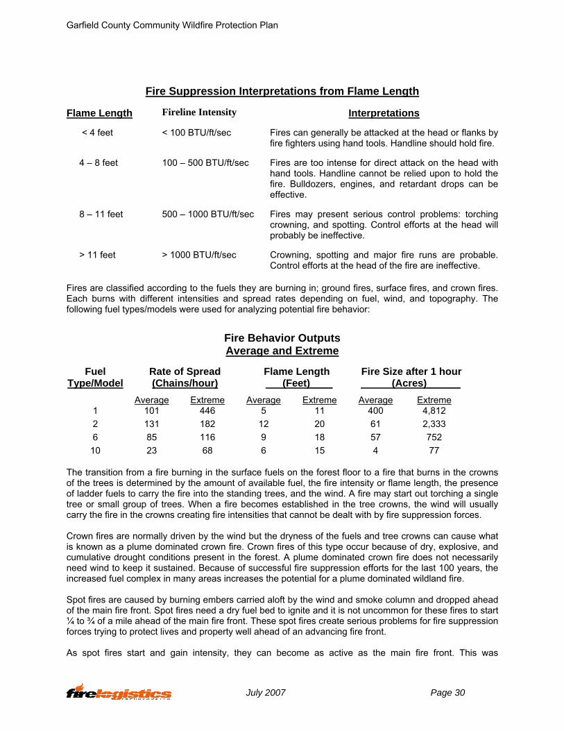
Garfield County Community Wildfire Protection Plan
Fire Suppression Interpretations from Flame Length
Flame Length Fireline Intensity Interpretations
< 4 feet < 100 BTU/ft/sec Fires can generally be attacked at the head or flanks by fire fighters using hand tools. Handline should hold fire.
4 – 8 feet 100 – 500 BTU/ft/sec Fires are too intense for direct attack on the head with hand tools. Handline cannot be relied upon to hold the fire. Bulldozers, engines, and retardant drops can be effective.
8 – 11 feet 500 – 1000 BTU/ft/sec Fires may present serious control problems: torching crowning, and spotting. Control efforts at the head will probably be ineffective.
> 11 feet > 1000 BTU/ft/sec Crowning, spotting and major fire runs are probable. Control efforts at the head of the fire are ineffective.
Fires are classified according to the fuels they are burning in; ground fires, surface fires, and crown fires. Each burns with different intensities and spread rates depending on fuel, wind, and topography. The following fuel types/models were used for analyzing potential fire behavior:
Fire Behavior Outputs Average and Extreme
Rate of Spread (Chains/hour)
Flame Length (Feet)____
Fire Size after 1 hour (Acres)______
Fuel Type/Model
Average Extreme Average Extreme Average Extreme 1 101 446 5 11 400 4,812 2 131 182 12 20 61 2,333 6 85 116 9 18 57 752
10 23 68 6 15 4 77 The transition from a fire burning in the surface fuels on the forest floor to a fire that burns in the crowns of the trees is determined by the amount of available fuel, the fire intensity or flame length, the presence of ladder fuels to carry the fire into the standing trees, and the wind. A fire may start out torching a single tree or small group of trees. When a fire becomes established in the tree crowns, the wind will usually carry the fire in the crowns creating fire intensities that cannot be dealt with by fire suppression forces. Crown fires are normally driven by the wind but the dryness of the fuels and tree crowns can cause what is known as a plume dominated crown fire. Crown fires of this type occur because of dry, explosive, and cumulative drought conditions present in the forest. A plume dominated crown fire does not necessarily need wind to keep it sustained. Because of successful fire suppression efforts for the last 100 years, the increased fuel complex in many areas increases the potential for a plume dominated wildland fire. Spot fires are caused by burning embers carried aloft by the wind and smoke column and dropped ahead of the main fire front. Spot fires need a dry fuel bed to ignite and it is not uncommon for these fires to start ¼ to ¾ of a mile ahead of the main fire front. These spot fires create serious problems for fire suppression forces trying to protect lives and property well ahead of an advancing fire front. As spot fires start and gain intensity, they can become as active as the main fire front. This was
July 2007 Page 30

Garfield County Community Wildfire Protection Plan
experienced during the several of the fires in 2006. Some fires travel so quickly through a combination of crowning and spotting that there is absolutely no way for fire suppression forces to gain control and not put fire fighters in unsafe situations. Many of the timber stands in the Garfield County are susceptible to crown fires because of the presence of ladder fuels, heavy, down woody debris on the forest floor and mature or over-mature age classes of the timber stands. This is an incentive for private landowners, county, state and federal agencies in the county to implement a hazardous fuels treatment program on a landscape scale. 5.8. Fire Behavior Modeling The Woods Coulee Fire The following hypothetical fire will describe the potential fire threat that exists annually in Garfield County. The fire was simulated using the topography on site, typical fuel models present, and the most probable weather under these severe burning conditions. The values predicted are only approximations, but never the less provide a valuable estimate of fire behavior under comparable conditions. The calculated fire size at 1 hour assumes a continuous fuel bed with constant conditions. This exercise makes the following assumptions:
• Garfield County climate and fuel moisture conditions are within those normally found in the County by early August.
• The weather event that ignited the fire is followed by a strong high pressure system. • The fire is multi-jurisdiction and crosses agency boundaries. • Structures will be threatened
This Woods Coulee Fire was started by a lightning storm that moved through the county on the evening of August 11th. The storm contained a minor amount of moisture, which kept the fire from spreading. The storm started a number of other fires that were detected by local residents and extinguished Garfield County, BLM and FWS. The Woods Coulee Fire, however, went undetected and smoldered through the night. On the morning of August 12th the weather pattern returned to the normal very warm dry system of August. An extended weather forecast from the Billings Weather Service for Garfield County from August 12th through August 15th indicates an extremely warm air mass forming over the area with relative humilities in the single digits. At approximately 1000 hours, the relative humidity dropped below 20%, the Woods Coulee Fire begins to become active. Winds, from the southwest, blowing at 20 mph moved the fire from the bottom of Woods Coulee onto the southwest aspect that contains a mix of grasses and over mature sage brush. By 1200 hours, the temperature has now reached 80 degrees, the wind out of the southwest remains at a constant 20 miles per hour and the relative humidity continues to drop. After one hour the fire is approximately 60-75 acres and by two hours the fire has reached a size of over 600 acres (See Figure 11 and Behave Fire Modeling Map in Section 10.5).
Figure 11.
July 2007 Page 31

Garfield County Community Wildfire Protection Plan
The fire, now burning in the mixed fuel bed is beginning to spread rapidly upslope. Detection of the fire was made by the residents of the subdivision and several adjacent ranches. Short distance spotting propagates the fire spread as it moves into a number of heavy wooded draws, ridges and coulees. A transition into a crown fire eliminated the opportunity for direct attack options, by the responding BLM and Garfield County RFD suppression resources. A Type III organization is formed between the County and BLM. A DNRC Fire Advisor has been ordered. Additional air and ground resources have been ordered. The County Fire Warden has requested mutual aid assistance from adjacent counties for structure protection and county backup. By 1500 hours, the fire has grown to 1,800 acres and is threatening the subdivision. Those structures in front of this fire would certainly be in jeopardy without an adequate asset protection zone (defensible space) and most likely could not be protected due to the size and scope of this event. At 1530 hours the Garfield County Sheriff issues an evacuation order for the subdivision and several adjacent ranches. A meeting is held between the Garfield County Fire Warden, Garfield County Commissioners, Department of Natural Resources and BLM to assess the fire situation. Jointly they have come to a decision that due to the complexity of the fire and the potential loss of structures, that an Incident Management Team will be ordered. There is some discussion whether it needs to be a Type I or Type II team. The complexity analysis for the decision is reviewed and a Type I Team is ordered. The request to order a Type I Team is passed through dispatch in Miles City. Miles City Dispatch informs the Garfield County officials that the two Northern Rockies Teams are on assignment and the closest Type I Team would not be on site for 36 hours. With that information, a Type II Team is ordered and expected to be on the Woods Coulee Fire for an in briefing at 2200 hours that evening. By 1800 hours the fire has been actively burning for eight hours and is now 4,800 acres. As the area loses the energy from the sun as it sets around 2100 hours, the fire behavior becomes more subdued, but due the poor humidity recovery, burns actively through the night time hours. At 0600 the following morning, the fire has been burning for twenty hours. The Type II Team take command of the fire which in now over 11,000 acres and has approximately fifteen miles of open line. This scenario is one that has been played out numerous times in Garfield County. It depicts that complexity of the fire workload and the skill levels that are required to manage them. Due to the size of Garfield County and its active fire load, it is not possible to detect and respond to all the ignitions that start within the county. Joint ownership of the fire suppression response between the County, DNRC, BLM and FWS is a very important part of successfully managing a complex wildland fire workload. 5.9. Fire Effects Assessment Wildland fires generally have three possible outcomes on forested areas. They can be lethal, non-lethal or mixed. These outcomes are alluded to in 5.1 Fire Regime Condition Class. A broad definition of each follows:
Figure 12.
Lethal – Fire is of high enough intensity
and long enough duration to cause mortality in all or most of the trees and shrubs in the burned area. This result is likely in a hardwood ecosystem but the
July 2007 Page 32

Garfield County Community Wildfire Protection Plan
exception in a healthy ponderosa pine ecosystem. It can result, however, from severe burning conditions and/or unnaturally high fuel accumulations in the forest. When a lethal fire occurs it will be evident for decades that the area has been burned (See Figure 12).
Non-lethal – Fire is not of high enough intensity or long enough duration to kill the trees in the
burned area. This is a more normal result in a healthy ponderosa pine ecosystem since the trees have adapted to fire by producing a thick bark. This bark protects the tree’s cambium from heat. Within two years of a non-lethal burn almost all evidence of the fire has disappeared.
Mixed – Fire will create significant areas of both lethal and non-lethal effects within the burned
area.
Unless a lethal or mixed fire is experienced, such as in 2006, a wildland fire burning in Garfield County has a much higher probability of negatively impacting human improvements, livestock and forage then it does creating any long term damage to natural resources. While wind driven, high intensity fire did occur in the county in 2006, most fires during more normal years are expected to be non-lethal or mixed. They may kill pockets of trees in places like draws and steep slopes but many trees will survive. A ponderosa pine can have over 60% of its crown scorched and it can still produce new needles the following year. The most significant natural resource loss from a non-lethal fire may be the short-term loss of forage for livestock. Landowners can reduce the exposure of their buildings, structures and themselves to a spreading fire. Asset protection and fuel modification zones, which may include grazed areas, should be in place around sites needing protection. This is particularly effective on the south and west sides or down slope from such areas since most fires will progress to the north and east or upslope. Exceptions to this general rule can occur when a thunderstorm is in the vicinity of the fire and downdrafts from it cause the fire to spread erratically. It is imperative that any new start be controlled as soon as possible. If a fire goes unattended it will continue to spread making eventual control more labor intensive and probably more difficult as it gets into new fuel sources. It also increases the chances of the fire being exposed to some type of severe weather event that can create a dangerous situation for life and property including those of the firefighters.
July 2007 Page 33

Garfield County Community Wildfire Protection Plan
6. Risk Assessment A fundamental part of any fire plan is identifying what you might lose in a wildland fire, known as assets or values at risk. 6.1. Values at Risk The primary intent of fire protection is to protect the values at risk and maintain healthy forest and grassland ecosystems. The purpose of a successful fire management program is to reduce the risks associated with values that are important to the county, its citizens, and natural resources. Values at risk will be used to assist fire protection agencies in prioritizing mitigation projects. Some of the values at risk in Garfield County are:
Health & Safety – Firefighters & Public Property, Improvements & Facilities – Private & Public Recreation/Community Impacts – Economic & Social Forest/Ecosystem Health Timber, Grazing And Hay
6.1.2. Health and Safety Fire fighter safety should never be compromised Garfield County needs to maintain the safety of their firefighters. Thorough situational awareness on the part of the firefighter and strong incident management by the fire department leadership is critical to the safety of personnel. Wildland fires are capable of moving over significant distances in a short period of time. It is possible that firefighting resources could become trapped during one of these events if they do not maintain a constant situational awareness. Garfield County, under current drought conditions, has the potential to have multiple complex wildland fire situations that could conceivably extend for several months. Garfield County Fire Department should work toward expanding its leadership capability so the county can simultaneously deal with complex multiple ignitions. In 1997, the “TriData Study: Wildland Firefighter Safety Awareness Study” was commissioned to find ways to improve firefighter safety. Of the 114 recommendations, the #1 recommendation was to “Implement a large-scale, long-range fuel management program.” Fire protection agencies, county officials, and the public must insist on hazardous fuel reduction efforts on a landscape-basis if they are truly serious about improving safety of not only firefighters but the public in general. 6.1.3. Property, Improvements & Facilities Few wildland fires burn where there is not some eventual threat to homes, ranch out buildings or other structures, fences, power lines, communication sites, or some other type of infrastructure. Fuel treatments (asset protection zones, see Resources Section 10.6) in the immediate area around structures, designed to reduce wildland fire intensity, can dramatically improve their probability of survival. However, restricting treatments to these areas does little to protect other values-at-risk, some of which may be equally or more important from a neighborhood and/or a community standpoint. 6.1.4. Recreation Opportunities to enjoy outdoor recreation activities can also be severely hampered by wildland fire and fires can have an adverse effect on the economy of Garfield County. The Hell Creek recreation area has
July 2007 Page 34

Garfield County Community Wildfire Protection Plan
had as many as 4,500 visitors on a peak day during the summer. Areas such as this could be closed to the public for extended periods of time during extreme fire danger. Often these closures and restrictions occur in early fall during up-land and migratory bird and big-game hunting seasons when many non-county residents have plans to travel to the area , Figure 13.
Figure 13.
6.1.5. Forest/Ecosystem Health See Section 5.4 Local Fire Ecology. 6.1.6. Timber, Grazing and Hay The Bureau of Land Management and the Fish and Wildlife Service are responsible for providing for grazing on federal administered lands. There is no timber management on F&WS lands and limited opportunities for timber harvest on BLM, state or private lands. Some salvage has occurred on these lands after large fires.
Agriculture and grazing are two of the primary uses on the remainder of the private lands in Garfield County. 6.2. Risk Estimation The purpose of our fire hazard assessment model is to develop a basic fire risk assessment and to prioritize areas within a county. The assessment consists of three sub-models: fuel hazard, values at risk, and risk and was designed with the following criteria in mind:
• The model is descriptive and not predictive. • The assessment is used to prioritize area for further analysis. • Each model is analyzed separately before being reviewed for an overall risk rating in order to
avoid conflicts between values. 6.2.1. Fuel Hazard Sub-Model Hazard parameter is defined as the physical or biological factors resulting in similar fire behavior characteristics and may result in an undesired wildfire event. The model was developed using slope, aspect, elevation and land cover type. Each criteria was weighted with land cover type weighted X 10 the slope, aspect, and elevation. A low, moderate or high rating indicates the potential for extreme fire behavior. 6.2.2. Values at Risk Sub-Model Values at Risk, or the human development data parameter, are defined as natural or developed features that can be affected by fire. Attributes for parcels with structures are extracted from the CAMA data and a point value is assigned for each parcel based on structure or residence present on the parcel. 6.2.3. Risk Sub-Model Risk is defined as potential risk to wildfire and is determined by the number of fire ignitions over a time period. Fire ignition points combined with the presence of railroads, roads, and residential parcels or structures are totaled and assigned a low, moderate, or high rating.
July 2007 Page 35

Garfield County Community Wildfire Protection Plan
6.2.4. Final Fire Hazard Assessment A grid or vector layer of accumulated point value will be created for each of the three models. The models will be represented separately and assigned a low, moderate or high risk for catastrophic fires. The final base map will consists of the fuel hazard model, in 30m raster format, assigned low, moderate, or high fire hazard. This hazard model will be overlaid with the values at risk (structures) and risk (historical fire occurrences and potential fire occurrence as represented by human activity near roads, railroads, and houses) models. A final rating fire hazard rating of low, moderate or high will be assigned each watershed and will identify areas in need of further assessment, Figure 14 (See Final Fire Hazard Assessment in Map Section 10.5).
Figure 14.
In looking at the GIS generated maps of Garfield County some areas of potential risk began to take form. When the fuel models are overlain with potential occurrence the areas most likely to experience a wildland fire can be identified. By adding the areas of human occupation or high value one can begin to assign priorities for protection. As with the federal agencies, the county’s first priority is protection of human life and secondly, personal property. 6.2.5. Discussion of Risk Most working ranches are located in open areas and have adequate clearing around them to hypothetically protect them from crown fire or a running surface fire. A problem can occur if there is too much clutter or untended vegetation around their structures however, that would allow for a simple surface fire to ignite those structures. Subdivision structures are inherently more vulnerable. People who own them often fail to recognize the relationship between the amount of vegetation around their structures and the threat to that structure from a wildfire. Some are even obstinate about that point refusing to remove any vegetation even though its continued presence reduces the probability that their home will survive a wildfire to almost zero. Firefighters must be very careful to look out for their own welfare first when asked to protect a structure where the owner has refused to do any work to enhance that structure’s probability of surviving a wildland fire. The following list represents Garfield County’s current priorities for fire protection:
July 2007 Page 36

Garfield County Community Wildfire Protection Plan
East and West Fort Billings Subdivision Musselshell Breaks (Angel Hill) Subdivision Hell Creek Recreation Area Jordan Mosby Cohagen Sand Springs Brussett All of Garfield County can be considered wildland urban interface due to extended drought
In looking at the GIS layered map of Garfield County it is apparent why these priorities have been established. The subdivisions represent an aggregation of individual private investments. They are located a considerable distance from Jordan but the County Fire Chief has positioned slip-on units in close proximity, wherever possible. The structures vary in value considerably but each is important to its owner. The personal threat to the occupants in the event of a major fire is of major concern. The limitations of the road system make evacuation uncertain and dependent on early notification. The potential for delays and/or accidents is considerable when the occupants are trying to egress and the protection resources are trying to ingress. The road into the special use cabins at Hell Creek is a little shorter and in better condition. There is less immediate threat to individuals because of the proximity of the lake. The structures are at risk, however, because of the significant fuel bed lying southwest of them and the difficulty of access to any emerging fire in that fuel bed. History has proven the possibility for large wildland fires in this part of the state when enough continuous fuels are available and when certain weather conditions are present. During one of these events, the actions that have been taken beforehand will generally prove to be as effective as any actions taken during the event. When conditions of extreme fire behavior exist little can be accomplished aside from evacuating people from harms way and keeping fire fighters in safe positions. Any fuel modification efforts that have been completed prior to the event will greatly enhance the fire fighter’s efforts to protect property during the event.
July 2007 Page 37
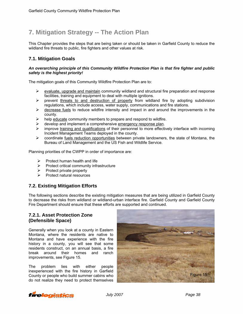
Garfield County Community Wildfire Protection Plan
7. Mitigation Strategy -- The Action Plan This Chapter provides the steps that are being taken or should be taken in Garfield County to reduce the wildland fire threats to public, fire fighters and other values at risk. 7.1. Mitigation Goals An overarching principle of this Community Wildfire Protection Plan is that fire fighter and public safety is the highest priority! The mitigation goals of this Community Wildfire Protection Plan are to:
evaluate, upgrade and maintain community wildland and structural fire preparation and response facilities, training and equipment to deal with multiple ignitions.
prevent threats to and destruction of property from wildland fire by adopting subdivision regulations, which include access, water supply, communications and fire stations.
decrease fuels to reduce wildfire intensity and impact in and around the improvements in the county.
help educate community members to prepare and respond to wildfire. develop and implement a comprehensive emergency response plan. improve training and qualifications of their personnel to more effectively interface with incoming
Incident Management Teams deployed in the county. coordinate fuels reduction opportunities between private landowners, the state of Montana, the
Bureau of Land Management and the US Fish and Wildlife Service. Planning priorities of the CWPP in order of importance are:
Protect human health and life Protect critical community infrastructure Protect private property Protect natural resources
7.2. Existing Mitigation Efforts The following sections describe the existing mitigation measures that are being utilized in Garfield County to decrease the risks from wildland or wildland-urban interface fire. Garfield County and Garfield County Fire Department should ensure that these efforts are supported and continued. 7.2.1. Asset Protection Zone (Defensible Space) Generally when you look at a county in Eastern Montana, where the residents are native to Montana and have experience with the fire history in a county, you will see that some residents construct, on an annual basis, a fire break around their homes and ranch improvements, see Figure 15. The problem lies with either people inexperienced with the fire history in Garfield County or people who build summer cabins who do not realize they need to protect themselves
Figure 15.
July 2007 Page 38

Garfield County Community Wildfire Protection Plan
from wildland fires. As future development occurs within the county, the Board of County Commissioners should ensure that Firewise principles are adopted and that there are adequate development regulations to provide and maintain asset protection zones in these developments (See Asset Protection Zone Guidelines in Resources Section 10.4). 7.2.2 Fire Protection Response Relatively long travel distances and slow travel times for fire suppression resources are the norm in Garfield County. The County Fire Chief has located the two Department of Natural Resource engines and sixteen county slip (See Figure 16) on units as strategically as he can throughout the county within the opportunities that exist. Each engine must be hosted, maintained and operated by a willing volunteer. Two water tenders are also located at Jordan to support the County Fire Department with water. When a fire is reported the volunteers are notified and they respond on a closest forces concept. They also respond to new ignitions reported on CMR and BLM administered lands. In many cases, the actual land ownership cannot be accurately determined until initial attack is in progress. When fires are located on lands other than CMR or BLM, the county fire fighters continue their actions until the fire is controlled. One of the most important decisions that must be made when a closest force resource arrives at the scene near one of the subdivisions is whether to spend their limited time on attempting suppression action or beginning evacuation of any threatened structures. It is a routine decision on low to high fire
danger days but could become very critical on very high or extreme days. The County Fire Chief has been very successful in recruiting volunteers and currently has around 100 across Garfield County. He has also been very effective in getting them to meet the physical fitness standard which has been a controversial issue in some other eastern counties. When responding to a fire on federal lands that has already been initial attacked by county fire forces the federal Incident Commander will either release the county forces or continue using them depending on the situation. If the fire is already contained the IC will most likely ask
the county fire fighters if they wish to be released and, if so, continue the control and mop up with federal firefighters. When the fire is not contained or if the county forces are still needed, the IC should continue to use them. The Montana DNRC will pay the County fire fighters wages for their assistance on any fire on federal lands according to existing agreements.
Figure 16
7.3. Coordinated Prevention, Protection Projects, and Response Plan Future efforts in planning and implementation of prevention, mitigation and response project should be closely coordinated between Garfield County and theiState of Montana. It is likely that some projects would be more effective if implemented on the lands of two or more jurisdictions rather than by a single entity. Cooperation and coordination will also result in avoiding duplicating efforts or overlooking opportunities to protect values at risk.
r cooperating partners, i.e., BLM, FWS and the
an effort to reduce new fire starts during periods of Figure 17 Invery high or extreme fire danger, there is a statewide process for instituting fire restrictions and closures by
July 2007 Page 39

Garfield County Community Wildfire Protection Plan
zone in the Northern Rockies Geographic area. Garfield County is in the Eastern Montana Zone, Figure 17. Garfield County Fire Department and its cooperators need to be coordinated in this process to ensure close communications and common actions occur during critical periods of fire danger. 7.4. Prioritization Process
ecommended projects have been prioritized based on the risk estimation in Section 6.2 (See 7.6
.5. Recommended Projects and Programs
his area describes recommended projects and actions that address the mitigation goals of the Garfield
.5.1. Vegetation Management/Fuel Modification Projects
his section addresses specific actions to reduce fuel loads, whether in forests, brush, or grasslands.
roposed Project 7.5.1.1 – Form a collaborative planning group (Fire Safe Council) with the BLM and
roject Coordinator – Garfield County FD
roposed Project 7.5.1.2 – The Garfield County Board of County Commissioners should designate the
East and West Fort Billings Subdivision ion
n gs
field County can be considered wildland urban interface due to extended drought
his will support decisions regarding fuel reduction efforts on adjacent Federal Lands. Any applicable
roject Coordinator – Garfield County Fire Warden
ecommended Project 7.5.1.3 – Identify strategic fuel break locations, throughout the county, along
roject Coordinator –Garfield County Fire Warden, BLM and FWS
.5.1.1. Thinning and Limbing
ivilcultural treatment of fuels is a technique used to eliminate a portion of the fuels in forested areas.
RPrioritized Actions). 7 TCounty CWPP. 7 T PCMR, ranchers, Garfield County Fire Department, Garfield County Disaster & Emergency Services, Board of County Commissioners, power companies and other cooperators, and others to plan fuel reduction projects on a landscape basis. P Pfollowing as wildland-urban interface areas in Garfield County:
Musselshell Breaks (Angel Hill) Subdivis Hell Creek Recreation Area Jordan Mosby Cohage Sand Sprin Brussett All of Gar
Tactions should be coordinated with the Missouri Breaks Interface Project currently being worked on by federal fire planners. P Rcounty roads that are either mail routes or school bus routes to break up the continuity of the CRP and/or wildland fuels. The fuel breaks should be constructed as wide as possible along both sides of the county road to provide an opportunity to anchor or suppress a fire. P 7 S
July 2007 Page 40
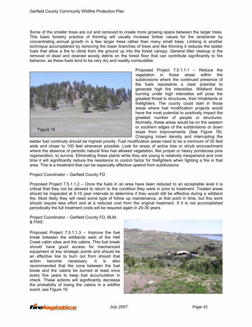
Garfield County Community Wildfire Protection Plan
Some of the smaller trees are cut and removed to create more growing space between the larger trees. This basic forestry practice of thinning will usually increase timber values for the landowner by concentrating annual growth in a few larger trees rather than many small trees. Limbing is another technique accomplished by removing the lower branches of trees and like thinning it reduces the ladder fuels that allow a fire to climb from the ground up into the forest canopy. General litter cleanup is the removal of dead and downed woody debris on the forest floor that can contribute significantly to fire behavior, as these fuels tend to be very dry and readily combustible.
Proposed Project 7.5.1.1.1 – Reduce the
d
roject Coordinator – Garfield County FD
roposed Project 7.5.1.1.2 – Once the fuels in an area have been reduced to an acceptable level it is
roject Coordinator – Garfield County FD, BLM,
roposed Project 7.5.1.1.3 – Improve the fuel
vegetation in those areas within the subdivisions where the continued presence of the fuels represents a clear potential to generate high fire intensities. Wildland fires burning under high intensities will pose the greatest threat to structures, their inhabitants or firefighters. The county could start in those areas where fuel modification projects would have the most potential to positively impact the greatest number of people or structures. Normally, these areas would be on the western or southern edges of the subdivisions or down slope from improvements (See Figure 18). Changing crown density and interrupting the ification areas need to be a minimum of 50 feet
wide and closer to 100 feet whenever possible. Look for areas of active tree or shrub encroachment where the absence of periodic natural fires has allowed vegetation, like juniper or heavy ponderosa pine regeneration, to survive. Eliminating these plants while they are young is relatively inexpensive and over time it will significantly reduce the resistance to control factor for firefighters when fighting a fire in that area. This is a treatment that can be especially effective upwind from subdivisions.
Figure 18
ladder fuel continuity should be highest priority. Fuel mo
P Pcritical that they not be allowed to return to the condition they were in prior to treatment. Treated areas should be inspected at 5-10 year intervals to determine if they would still be effective during a wildland fire. Most likely they will need some type of follow up maintenance, at that point in time, but this work should require less effort and at a reduced cost from the original treatment. If it is not accomplished periodically the full treatment costs will be required again in 20-30 years. P& FWS Pbreak between the wildlands west of the Hell Creek cabin sites and the cabins. This fuel break should have good access for mechanized equipment at key strategic points and should be an effective line to burn out from should that action become necessary. It is also recommended that the zone between the fuel break and the cabins be burned at least once every five years to keep fuel accumulation in check. These actions will significantly decrease the probability of losing the cabins in a wildfire event, see Figure 19.
Figure 19
July 2007 Page 41
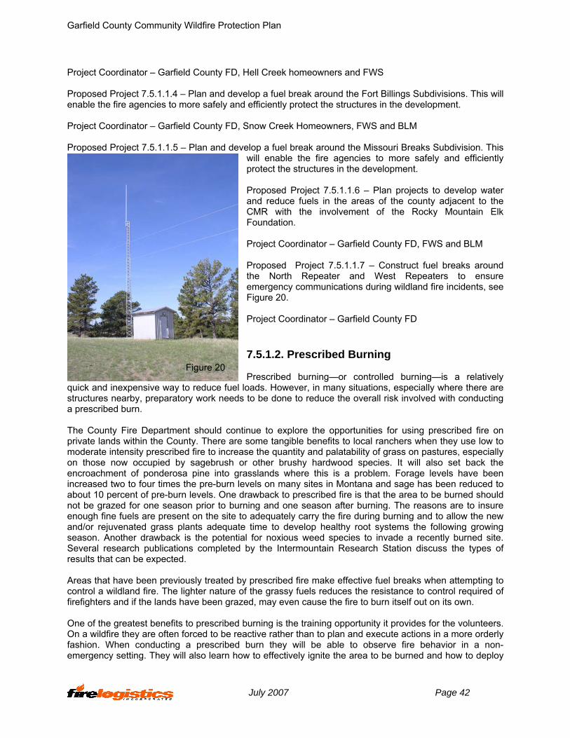
Garfield County Community Wildfire Protection Plan
Project Coordinator – Garfield County FD, Hell Creek homeowners and FWS
roposed Project 7.5.1.1.4 – Plan and develop a fuel break around the Fort Billings Subdivisions. This will
roject Coordinator – Garfield County FD, Snow Creek Homeowners, FWS and BLM
roposed Project 7.5.1.1.5 – Plan and develop a fuel break around the Missouri Breaks Subdivision. This
roposed Project 7.5.1.1.6 – Plan projects to develop water
roject Coordinator – Garfield County FD, FWS and BLM
roposed Project 7.5.1.1.7 – Construct fuel breaks around
roject Coordinator – Garfield County FD
.5.1.2. Prescribed Burning
rescribed burning—or controlled burning—is a relatively el l
structures nearby, preparatory work needs
he County Fire Department should continue to explore the opportunities for using prescribed fire on
reas that have been previously treated by prescribed fire make effective fuel breaks when attempting to
ne of the greatest benefits to prescribed burning is the training opportunity it provides for the volunteers.
Penable the fire agencies to more safely and efficiently protect the structures in the development. P P
will enable the fire agencies to more safely and efficiently protect the structures in the development. Pand reduce fuels in the areas of the county adjacent to the CMR with the involvement of the Rocky Mountain Elk Foundation. P Pthe North Repeater and West Repeaters to ensure emergency communications during wildland fire incidents, see Figure 20. P 7 P
quick and inexpensive way to reduce fu oads. However, in many situations, especially where there are to be done to reduce the overall risk involved with conducting
a prescribed burn.
Figure 20
Tprivate lands within the County. There are some tangible benefits to local ranchers when they use low to moderate intensity prescribed fire to increase the quantity and palatability of grass on pastures, especially on those now occupied by sagebrush or other brushy hardwood species. It will also set back the encroachment of ponderosa pine into grasslands where this is a problem. Forage levels have been increased two to four times the pre-burn levels on many sites in Montana and sage has been reduced to about 10 percent of pre-burn levels. One drawback to prescribed fire is that the area to be burned should not be grazed for one season prior to burning and one season after burning. The reasons are to insure enough fine fuels are present on the site to adequately carry the fire during burning and to allow the new and/or rejuvenated grass plants adequate time to develop healthy root systems the following growing season. Another drawback is the potential for noxious weed species to invade a recently burned site. Several research publications completed by the Intermountain Research Station discuss the types of results that can be expected. Acontrol a wildland fire. The lighter nature of the grassy fuels reduces the resistance to control required of firefighters and if the lands have been grazed, may even cause the fire to burn itself out on its own. OOn a wildfire they are often forced to be reactive rather than to plan and execute actions in a more orderly fashion. When conducting a prescribed burn they will be able to observe fire behavior in a non-emergency setting. They will also learn how to effectively ignite the area to be burned and how to deploy
July 2007 Page 42

Garfield County Community Wildfire Protection Plan
the holding forces to make the best use of available skills and equipment. All of this can be accomplished while functioning in the serious but more controlled environment of a prescribed fire. Proposed Project 7.5.1.2.1 – Opportunities may arise from planning efforts to jointly conduct prescribed
roject Coordinator – Garfield County FD/FWS/BLM
roposed Project 7.5.1.2.2 – Work with the Garfield County Weed Department to establish a wash
roject Coordinator – Garfield County Weed and Fire Department
.5.1.3. Grazing
arfield County can expect some continued encroachment of fires off of timbered grounds, such as the
roposed Project 7.5.1.3.1 - Landowners should be encouraged to sustain grass ecosystems through
roject Coordinator – Garfield County FD
.5.1.4. Industrial Resource Management
roposed Project 7.5.1.4.1 – Request that the
roject Coordinator – Garfield County FD
.5.1.5. Biomass Utilization
roposed Project 7.5.1.5.1 – Explore any opportunities
roject Coordinator – Garfield County Economic Development Association
roposed Project 7.5.1.5.2 – Explore involving the local RC&D or other economic development agencies
roject Coordinator – Economic Development Groups in Garfield County
roposed Project 7.5.1.5.3 – Explore the possibility of converting the existing boilers in Jordan to multi-
fire projects. Garfield County Fire Department should participate in these burns to improve their training, qualifications and experience in wildland fire management. Efforts such as these promote better interagency cooperation and working relationships. P Prequirement for contractors, other local and government apparatus that conduct prescribed burns within the county. P 7 GFWS and BLM onto private ownership. Pgrazing and to control tree encroachment in those areas, particularly where they are adjacent to heavily timbered federal lands. P
Figure 21
7 Pcompany operating in the Cat Creek oil field develop and maintain a facilities protection plan for wildfire and that they identify high value improvements and special hazards that would present a risk to County fire fighters responding to the area, see Figure 21. P 7 P with the Eastern Montana Biomass Task Force to dispose of biomass material on either a profit or break even basis. If there is no market for chips or hog fuel in the area and no possibility of utilization for posts or poles, look at designating a site or sites where material can be safely piled and burned during low fire danger periods. Continued use of some of the material for fire wood by community members is encouraged. P Pin eastern Montana to work with K & K Sawing and try to utilize that sawmill to make some products out of fuel reduction project biomass. P P
July 2007 Page 43

Garfield County Community Wildfire Protection Plan
fuel systems to burn biomass generated by fuels reduction projects. Project Coordinator – Economic Development Groups in Garfield County
.5.2. Safety Zones
he establishment of safety zones within some of the subdivisions is probably the best approach to
roposed Project 7.5.2.1 – Review each subdivision and determine if safety zones may be necessary
roject Coordinator – Garfield County FD, BLM and FWS
.5.3. Infrastructure Improvements
provements to improve local infrastructure are discussed in this section.
.5.3.1. Water Supply
lthough water supply is not a direct function of the Garfield County Fire Department, water supply
roposed Project 7.5.3.1.1 – Document the strategic water source plan for the county, which shows the
or – Garfield County FD
ncourage omeowners associations and individuals to develop water
.
servoirs at can be pre-positioned throughout the county during
arfield County Fire Warden
.3.2.1 – The Garfield County FD should
7 Tprotecting human life during a fast moving fire, especially when residents are faced with the alternative of trying to navigate narrow roads under smoky conditions. Any required clearance work on these identified areas should be accomplished prior to fire season as labor and equipment become available. One important point is to insure that the development of procedures, such as when to occupy them and what should and should not be taken into them, are clearly understood by anyone who may need to use them. Pconsidering ingress and egress issues as well as the surrounding fuel type. Where they are appropriate, assist the subdivision residents in determining where to locate them, what maintenance work needs to be done and how and when they should be used. P 7 Im 7 Aunquestionably impacts the structure fire suppression performance of the department. Water supply, or lack of water supply, indirectly affects the whole community through the insurance rates they pay. Pmost efficient sources of water to support wildland firefighting efforts. It will be necessary to enter into some types of arrangement with CMR to gain access to additional sites along Fort Peck Lake in order to reduce refill times to an acceptable level. GPS the locations of water supply points and work with the Garfield County Conservation District to develop a water supply map for Garfield County. Project Coordinat
Figure 22
Proposed Project 7.5.3.1.2 – Continue to ehsources that can be used by fire protection personnel Project Coordinator – Homeowners’ Associations Proposed Project 7.5.3.1.3 – Purchase portable rethwildland fire season. Project Coordinator – G 7.5.3.2. Utilities Proposed Project 7.5
July 2007 Page 44
Garfield County Community Wildfire Protection Plan
work with McCone Electric to ensure that the required clearances are maintained for all electrical
rdinator – Garfield County FD
one Electric Cooperative should provide power line safety emonstrations to the Garfield County Fire Department members.
nagers
nd-urban interface and structure fires includes the placement of tations, apparatus and personnel to meet the needs of the community.
to up-grade fire apparatus and quipment in Garfield County Fire Department.
ef with assistance of the Garfield County Board of County ommissioners.
7.5.3.3.2 – Work with the county commissioners to develop a long-term plan to provide tructural fire services to as many structures throughout the county as possible. One mechanism might be
D and Garfield County Commissioners
issioners should consider aking the position of the Garfield County Fire Chief a full-time position due to the complexity of the
f strategic fire control corridors, access points and ccess roads that are strategically placed throughout Garfield County to manage and control wildland
Establish protection from the elements for strategically located county and tate engines and tenders where it is not currently provided. Getting this equipment under some type of
transmission lines in the Garfield County, see Figure 22. Project Coo Proposed Project 7.5.3.2.2 – The McCd Project Coordinator – Garfield County FD and Power Company Ma 7.5.3.3. Emergency Response Emergency response to wildland, wildlas Proposed Project 7.5.3.3.1 – Develop a capital improvement plan e Project Coordinators – Garfield County Fire ChiC Proposed Projectswhat is called an ISO Engine, which is basically a beefed-up brush engine with ladders, breathing apparatus and some minor equipment. To qualify for Class 9 Fire Protection, an apparatus needs to have a pump capable of delivering 50 gpm or more at 150 psi and a tank of at least 300 gallons. There should be training records, which indicate date and time, location of fires, number of members, meetings, training sessions, maintenance of apparatus, etc. A roster of fire department personnel should be kept up to date. Equipment is 250 foot lengths of ¾ inch or 1 inch booster hose, 1 ½ pre-connects or equivalent with a nozzle, 2 portable fire extinguishers. Minimum size should be 20 BC with 10 BC 2A rating, one 12 ft ladder with folding hooks, one 24 foot extension ladder, one pick head axe, 2 electric hand lights, one pike pole, one bolt cutter, one closet tool and one crow bar. These standards qualify an engine and meets ISO to get your rating from a 10 to a 9. Project Coordinator – Garfield County F Proposed Project 7.5.3.3.3 – The Garfield County Board of County Commmwildland fire program. This will enable Garfield County Fire to stay fully engaged with interagency fire partners, Montana Wardens, Montana State Fire Chief’s Association, etc. Project Coordinator – Garfield County Commissioners Proposed Project 7.5.3.3.4 – Develop a plan and map oafires. This fuel break should have good access for mechanized equipment at key strategic points and should be an effective line to burn out from should that action become necessary. Project Coordinator – Garfield County Fire Warden, BLM, and F&WS 7.5.3.3.1. Fire Stations Proposed Project 7.5.3.3.1.1 –s
July 2007 Page 45

Garfield County Community Wildfire Protection Plan
cover will greatly extend the life of rubber and synthetic components such as tires and hoses. It will also reduce oxidation of metal components and will increase the overall reliability of the equipment. Project Coordinators – Garfield County Fire Department and Board of County Commissioners Proposed Project 7.5.3.3.1.2 – Continue pursuing a long term lease for the abandoned state highway
aintenance site in Jordan. Once acquired, develop a capital plan to finance the necessary modifications
ioners
nty fire fighters to meet all training quirements, wear their personal protective equipment and to take the firefighter pack test each year.
ef for the county fire chief by qualifying as many engine perators as possible to be Type IV or Type V Incident Commanders.
nt Commanders to request and understand a spot fire weather recast.
ordinator – Garfield County FD
training program which encompasses the County Fire Chief, ounty Sheriff’s office, Disaster and Emergency Service officials. and the County Commissioners as
& Programs
s to keeps records on fire responses to all reas within the county to establish a fire history and occurrence map. This information will be invaluable
r the County Assistance eam (CAT) as early as possible during an emerging incident to avoid experiencing key overhead
a requirement in the Garfield County Weed Plan that fire uppression equipment from outside the county be washed down prior to fire suppression activities to
mto provide a training room and office space for the Garfield County Fire Department. Project Coordinator – Garfield County Fire Department and Garfield County Commiss 7.5.3.3.2. Training, Certification, and Qualification Proposed Project 7.5.3.3.2.1 – Continue to encourage Coure Project Coordinator – Garfield County Fire Chief Proposed Project 7.5.3.3.2.2 – Provide some relio Project Coordinator – Garfield County FD Proposed Project 7.5.3.3.2.3 – Train Incidefo Project Co Proposed Project 7.5.3.3.2.4 – Develop aCparticipants. The purpose would be to maintain their currency with the fire program and to review their roles and responsibilities as government officials. This training would provide the skill level to determine the appropriate level of Incident Management Team (IMT) and the ability to write a delegation to the IMT, which would include the management objectives of local government for the emergency incident. Project Coordinator – Garfield County FD 7.5.3.3.3. Operational Procedures Proposed Project 7.5.3.3.3.1 – Garfield County Fire Chief needain establishing mitigation activities and future funding requirements. The records should include a GPS location of each fire under 100 acres and the perimeters of those over 100 acres. Project Coordinator – Garfield County FD and Garfield County Extension Agent Proposed Project 7.5.3.3.3.2 – Garfield County Fire Department should ordeTshortages and overloading Garfield County personnel. Project Coordinator – Garfield County FD Proposed Project 7.5.3.3.3.3 – Include seliminate weed seeds and other noxious species moving into Garfield County. Selected sites throughout
July 2007 Page 46
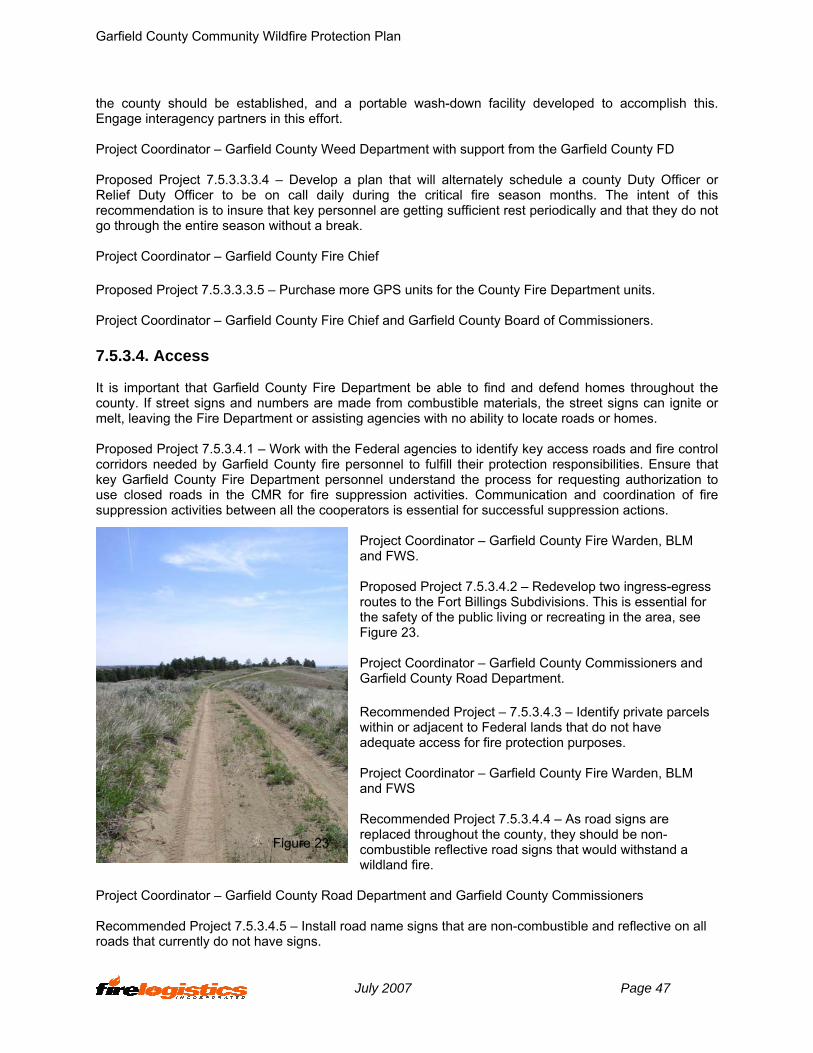
Garfield County Community Wildfire Protection Plan
the county should be established, and a portable wash-down facility developed to accomplish this. Engage interagency partners in this effort. Project Coordinator – Garfield County Weed Department with support from the Garfield County FD
cer or elief Duty Officer to be on call daily during the critical fire season months. The intent of this
f
S units for the County Fire Department units.
arfield County Fire Department be able to find and defend homes throughout the ounty. If street signs and numbers are made from combustible materials, the street signs can ignite or
e control orridors needed by Garfield County fire personnel to fulfill their protection responsibilities. Ensure that
LM nd FWS.
roject 7.5.3.4.2 – Redevelop two ingress-egress utes to the Fort Billings Subdivisions. This is essential for
rdinator – Garfield County Commissioners and arfield County Road Department.
Identify private parcels ithin or adjacent to Federal lands that do not have
en, BLM nd FWS
ded Project 7.5.3.4.4 – As road signs are placed throughout the county, they should be non-
a
D d Garfield County Commissioners
tive on all ads that currently do not have signs.
Proposed Project 7.5.3.3.3.4 – Develop a plan that will alternately schedule a county Duty OffiRrecommendation is to insure that key personnel are getting sufficient rest periodically and that they do not go through the entire season without a break. Project Coordinator – Garfield County Fire Chie Proposed Project 7.5.3.3.3.5 – Purchase more GP Project Coordinator – Garfield County Fire Chief and Garfield County Board of Commissioners. 7.5.3.4. Access It is important that Gcmelt, leaving the Fire Department or assisting agencies with no ability to locate roads or homes. Proposed Project 7.5.3.4.1 – Work with the Federal agencies to identify key access roads and firckey Garfield County Fire Department personnel understand the process for requesting authorization to use closed roads in the CMR for fire suppression activities. Communication and coordination of fire suppression activities between all the cooperators is essential for successful suppression actions.
Project Coordinator – Garfield County Fire Warden, B
Figure 23
a Proposed Prothe safety of the public living or recreating in the area, see Figure 23. Project CooG Recommended Project – 7.5.3.4.3 – wadequate access for fire protection purposes. Project Coordinator – Garfield County Fire Warda Recommenrecombustible reflective road signs that would withstand wildland fire.
epartment an Project Coordinator – Garfield County Road Recommended Project 7.5.3.4.5 – Install road name signs that are non-combustible and reflecro
July 2007 Page 47

Garfield County Community Wildfire Protection Plan
Project Coordinator – Garfield County R
Figure 24
oad Department
ce)
crease the chances for the home’s survival during a
e. omes near steep slopes and in heavy fuels will need
e radiant and convective heat current e n that is fire resistant.
ments develop and dopt local land use plans and ordinances that provide for the maintenance of defensible space and fuel
ome and cabin owners in Garfield County to develop and aintain an asset protection zone (defensible space) around their homes, cabins, ranch buildings and
ounty Conservation District
onstruction
ign, construction and/or cation. There are steps a homeowner or developer can take to reduce the chance of home catching fire,
ained to increase the chances of urviving a wildland fire without the intervention of the fire department.
ction, Design and Materials and rewise Construction Checklist to developers and homebuilders. Existing homeowners can use Is Your
7.5.4. Asset Protection Zone (Defensible Spa One of the single most important mitigating factors to inwildland-urban interface fire is the creation and maintenance of an asset protection zone (defensible space). Defensible space refers to an area around the home where the native vegetation has been modified to reduce the wildland/urban interface fire threat to the home and provides a safe area for fire fighters to work effectively and safely, Figure 24 (See Asset Protection Zone Guideline Table in Resources Section 10.4.4). Slope and fuels affect the size of the defensible spacHto clear additional vegetation to mitigate the effects of thlengths. The slopes should be planted to native vegetatio Proposed Project 7.5.4.1 - The National Fire Plan also suggests that local govern
s and flam
amanagement on municipal and private property.14 The Garfield County Commissioners should develop land use plans and ordinances that provide for defensible space and fuel management. Project Coordinator – Garfield County FD Proposed Project 7.5.4.2 – Encourage hmother important improvements. Project Coordinator – Garfield C 7.5.5. Recommended Building Materials/Firewise C A home may be vulnerable to a wildland/urban interface fire because of its desloor resist further damage if it does catch fire. There are three ways that a wildland fire can cause homes and businesses to catch fire – through radiation, convection and/or fire brands. In all cases, the home’s building materials and design play a significant role in establishing the level of exposure that can be tolerated before it ignites from radiation, convection, and/or fire brands. Homes in a wildland urban interface area can be designed and maints Proposed Project 7.5.5.1 – Recommend the use of Firewise Constru 15
16FiHome Protected From Wildfire Disaster? A Homeowner’s Guide to Wildfire Retrofit17 (See in Resources Section 10.4).
14 See www.westgov.org/wga/initiatives/fire/implem_plan.pdf15 Firewise Construction, Design and Materials, Stack, Colorado Forest Service Firewise Construction, Design and Materials, Stack, Colorado Forest Service 16 www.firewise.org16 www.firewise.org. 17 www.ibhs.org
July 2007 Page 48
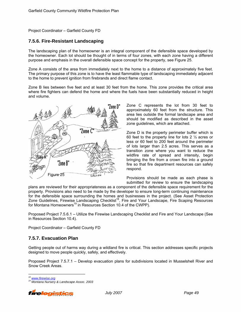
Garfield County Community Wildfire Protection Plan
Project Coordinator – Garfield County FD
n integral component of the defensible space developed by e homeowner. Each lot should be thought of in terms of four zones, with each zone having a different
y five feet. he primary purpose of this zone is to have the least flammable type of landscaping immediately adjacent
zone provides the critical area here fire fighters can defend the home and where the fuels have been substantially reduced in height
Zone C represents the lot from 30 feet to approximately 60 feet from the structure. This
r which is feet to the property line for lots 2 ½ acres or
should be made as each phase is bmitted for review to ensure the landscaping
their appropriateness as a compproperty. Provisions also need to be made by the devel
nd Fire and Your Landscape (See Resources Section 10.4).
unty FD
ay during a wildland fire is critical. This section addresses specific projects esigned to move people quickly, safely, and effectively.
r subdivisions located in Musselshell River and now Creek Areas.
7.5.6. Fire-Resistant Landscaping The landscaping plan of the homeowner is athpurpose and emphasis in the overall defensible space concept for the property, see Figure 25. Zone A consists of the area from immediately next to the home to a distance of approximatelTto the home to prevent ignition from firebrands and direct flame contact. Zone B lies between five feet and at least 30 feet from the home. Thiswand volume.
Figure 25
area lies outside the formal landscape area and should be modified as described in the asset zone guidelines, which are attached. Zone D is the property perimeter buffe60less or 60 feet to 200 feet around the perimeter of lots larger than 2.5 acres. This serves as a transition zone where you want to reduce the wildfire rate of spread and intensity, begin bringing the fire from a crown fire into a ground fire so that fire department resources can safely respond. Provisionssu
eviewed forplans are r onent of the defensible space requirement for the oper to ensure long-term continuing maintenance
for the defensible space surrounding the homes and businesses in the project. (See Asset Protection Zone Guidelines, Firewise Landscaping Checklist18, Fire and Your Landscape, Fire Scaping Resources for Montana Homeowners19 in Resources Section 10.4 of the CWPP). Proposed Project 7.5.6.1 – Utilize the Firewise Landscaping Checklist ain Project Coordinator – Garfield Co 7.5.7. Evacuation Plan Getting people out of harms wd Proposed Project 7.5.7.1 – Develop evacuation plans foS
18 www.firewise.org 19 Montana Nursery & Landscape Assoc. 2003
July 2007 Page 49

Garfield County Community Wildfire Protection Plan
Project Coordinator – Garfield County Sheriff and DES Coordinator
land fire issues is one of the most effective ways to reduce fire hazards, hether that be in K-12 schools, or programs designed for adults. Public education is one of the keys to
Firewise Community Program locally within the county for the ublic and continue that every other year. Integrate weeds and fire into any public education that is
cation kiosk’s in key locations throughout the county with irewise information, fire danger information and public safety messages.
long primary roadways in the county.
Firewise brochure.
e “Living with Fire in Montana” developed by issoula County Fire Protection Association to educate residents, realtors, fire and government officials
ervation District
rvation District’s newsletter to deliver fire afety messages and information about how to prepare for a wildland fire.
tions
planning, zoning, and construction methods have been largely cking or inadequate in high-risk fire areas, and need to be implemented in the future. Local government
t 7.5.9.1.1 – Consider amending the County Subdivision Regulations with some of the oncepts included in the Model Regulations in the Resources Section 10.4.
7.5.8. Public Education Educating residents about wildwthe success of fire management programs whether they are local, state or federal. Fire is an important issue for the public and public understanding is key to the fire agencies ability to effectively manage wildland fire and wildland fire incidents. Proposed Project 7.5.8.1 – Sponsor a pconducted during the Firewise Community Program. Project Coordinator – Garfield County FD Proposed Project 7.5.8.2 – Develop public eduF Project Coordinator – Garfield County, CMR and BLM Proposed Project 7.5.8.3 – Locate Fire Danger Signs a Project Coordinator – Garfield County, CMR and BLM Proposed Project 7.5.8.4 – Develop a specific Garfield County Project Coordinator – Garfield County Conservation District Recommended Project 7.5.8.5 – Utilize a program such as thMabout living in a wildland fire environment. Project Coordinator – Garfield County Cons Proposed Project 7.5.8.6 – Utilize the Garfield County Conses Project Coordinator – Garfield County Conservation District 7.5.9. Legal Requirements 7.5.9.1. Subdivision Regula History has shown past voluntary land use,lagoverning bodies have a responsibility to provide the commitment and leadership for the coordination, collaboration, and communication necessary to develop and implement building standards, land use and zoning regulations, and defensible space requirements necessary to reduce the risks in the wildland urban interface. Proposed Projecc
July 2007 Page 50

Garfield County Community Wildfire Protection Plan
Project Coordinator – Garfield County FD and Garfield County Board of County Commissioners
erns are ddressed in the subdivision review process for any future planned subdivision. The purpose for his input
the BLM both should review subdivisions adjacent to their rotection to ensure adequate fire protection features are designed into the projects.
ritten agreements and memorandums of nderstanding with cooperators. Follow up on those that have not yet been completed and insure annual
fires on BLM, CMR and county lands, respectively.
nt and expectations are for that agency when the responsible agency arrives at the
• how is that request processed and who must approve it.
• tain aviation resources such as air
e Chief, BLM and FWS
o periodically review is the jurisdictional sponsibilities for wildland fire on US Fish and Wildlife Service and Bureau of Land Management lands
d agreements with neighboring counties
Proposed Project 7.5.9.1.2 – The County Fire Chief needs to ensure that wildland fire concais to avoid creation or perpetuation of any untenable situations, from a fire protection standpoint. Issues such as road systems, water supply, building materials and covenants covering vegetation management are all of concern to the Fire Chief and they can directly affect his ability to be effective. Project Coordinator – Garfield County FD Proposed Project 7.5.9.1.3 – The CMR andp Project Coordinator – BLM and FWS, Garfield County Planning Department 7.5.9.2. Agreements, MOU’s & Operating Plans Proposed Project 7.5.9.2.1 – Review all verbal and wuoperating plans are completed when specified. The following key points should be adequately covered within the agreements so that there are no unanswered questions: • Clearly state who has jurisdiction for and will provide an IC for
• When one agency responds first to another agency’s fire, clarify what the rules of engagement, disengagemescene. When a complexity analysis indicates a Type III, Type II or Type I Incident Management Team is needed,
• Who will be the county liaison with that overhead team? Detail the process that the county needs to follow in order to obtankers and helicopters in a timely manner.
• Lay out reimbursement procedures.
Project Coordinator – Garfield County Fir Proposed Project 7.5.9.2.2 – One issue that it might be helpful trewithin Garfield County. Various federal laws place the responsibility for fire protection on the respective federal agencies for the lands administered by them. There are exceptions when another agency has been designated as the Protecting Agency by virtue of an agreement. This has not happened with any of the federal agencies but might be worth looking into since federal resources have reportedly had limited availability, even during the established season when the positions are supposed to be staffed. County firefighters are often the first and sometimes the only resources to arrive at fires on BLM or CMR lands. The County Fire Chief does assume protection for state lands, except for state lands within the CMR, within Garfield County. This assigned protection responsibility only involves initial attack on new fire starts. Once a fire escapes initial attack and extended attack efforts, the responsibility falls back to the home agency. A clear understanding of jurisdictional authorities will help all firefighters understand their roles within the county. Agreements and operating plans with BLM, USF&W, State of Montana and adjoining counties must be current and valid. Without these operating plan requirements being fulfilled, the likelihood of a misunderstanding among the parties concerned continues. Project Coordinator – Garfield County Fire Chief, BLM and FWS Proposed Project 7.5.9.2.3 – Either update or establish mutual ai
July 2007 Page 51

Garfield County Community Wildfire Protection Plan
and fire agencies to ensure the availability of adequate resources for wildland fire incidents.
ograms to ensure that a delegation of uthority is properly executed between the appropriate “Authority Having Jurisdiction” and the Type III, II,
ld County Fire Warden
Project Coordinator – Garfield County Fire Chief, BLM and FWS Proposed Project 7.5.9.2.4 – Develop materials and training praor I Incident Commanders. Project Coordinator – Garfie
July 2007 Page 52

Garfield County Community Wildfire Protection Plan
7.6. Prioritized Actions, Implementation Timeline
Proposed Project Table
Proposed Project Short Term (< 1 Year)
Medium Term(1-3 Years)
Long Term (3+ Years)
7.5.1.1 X 7.5.1.2 X 7.5.1.3 X 7.5.1.1.1 X 7.5.1.1.2 X 7.5.1.1.3 X 7.5.1.1.4 X 7.5.1.1.5 X 7.5.1.1.6 X 7.5.1.1.7 X 7.5.1.2.1 X 7.5.1.2.2 X 7.5.1.3.1 X 7.5.1.4.1 X 7.5.1.5.1 X 7.5.1.5.2 X 7.5.1.5.3 X 7.5.2.1 X 7.5.3.1.1 X 7.5.3.1.2 X 7.5.3.1.3 X 7.5.3.2.1 X 7.5.3.2.2 X 7.5.3.3.1 X 7.5.3.3.2 X 7.5.3.3.3 X 7.5.3.3.4 X 7.5.3.3.1.1 X 7.5.3.3.1.2 X 7.5.3.3.2.1 X 7.5.3.3.2.2 X
July 2007 Page 53

Garfield County Community Wildfire Protection Plan
Proposed Project Table (continued) Proposed Project Short Term
(< 1 Year) Medium Term
(1-3 Years) Long Term (3+ Years)
7.5.3.3.2.3 X 7.5.3.3.2.4 X 7.5.3.3.3.1 X 7.5.3.3.3.2 X 7.5.3.3.3.3 X 7.5.3.3.3.4 X 7.5.3.3.3.5 X 7.5.3.4.1 X 7.5.3.4.2 X 7.5.3.4.3 X 7.5.3.4.4 X 7.5.3.4.5 X 7.5.4.1 X 7.5.4.2 X 7.5.5.1 X 7.5.6.1 X 7.5.7.1 X 7.5.8.1 X 7.5.8.2 X 7.5.8.3 X 7.5.8.4 X 7.5.8.5 X 7.5.8.6 X 7.5.9.1.1 X 7.5.9.1.2 X 7.5.9.1.3 X 7.5.9.2.1 X 7.5.9.2.2 X 7.5.9.2.3 X 7.5.9.2.4 X
July 2007 Page 54

Garfield County Community Wildfire Protection Plan
8. Plan Monitoring and Review: How to Keep this Plan Active and Up-to-Date 8.1. Timeline DMA 2000 requires that plans be updated every five years. This does not mean you have to rewrite it or redo this entire process. Rather, you are required to review your mitigation plan. Proposed projects should be updated as the keeper of the plan becomes aware of new projects that might be implemented to mitigate a wildland fire problem. The prioritized project list should be revised every year based on new data and available dollars. The entire plan should be updated or reviewed on the same cycle as the pre-disaster mitigation plan. 8.2. Incorporation into Local Jurisdictional Plans This plan should be adopted by local Garfield County and the recommendations be incorporated into their other planning mechanisms, such as a County Growth Policy and Pre-Disaster Mitigation Plan.
July 2007 Page 55
Garfield County Community Wildfire Protection Plan
9. Summary and Conclusions 9.1. Analysis and Findings The complexity of the wildland fire program has significantly changed in Garfield County over the last 15 years, due the development of wildland-urban interface, long term drought, and changes in the wildland ecosystems. The leadership and the level of fire preparedness within Garfield County have been able to keep pace with this changing environment through the efforts of the County Fire Warden. The Garfield County Board of Commissioners need to recognize this effort and also need to be supportive of future needs of the County’s fire forces to further respond to a changing fire environment and the associated public safety risks. In the recommended projects and programs section of this report, Section 7.5, significant changes are recommended. Funding for many of these suggested projects and programs can be obtained through the National Fire Plan and FEMA grant programs. The Garfield County Board of Commissioners are strongly encouraged to utilize a grant writer to increase the wildland fire suppression, public education, training and qualifications capability of the Garfield County and County Fire Department.
July 2007 Page 56

Garfield County Community Wildfire Protection Plan
10. Appendices 10.1. Bibliography 10.2. Glossary 10.3. Public Education Materials 10.4. Resources 10.5. Maps
July 2007 Page 57