gap analyses - sussex archaeological society 14. gap analysis: the palaeolithic • part of this...
TRANSCRIPT

Gap Analyses

14 . gap analys is : the palaeolithic 71
1 4 . 1 . i n t r o d u c t i o n
he palaeolithic record of the countrysidesurroundingchichesterhasbeenthefocusofintensiveresearchduringthepastthirty
years. indeed, after thethamesbasinand,morerecently,thenorfolkcoast,nopartofthecountryhas been subject to such detailed field researchduringthisperiod.theworkofandrewWoodcockin the late1970sdidmuch todrawattention totherichpotentialofthesussexpalaeolithicrecordand the possibility of extensive preservation atamey’s eartham pit. the potential was realizedbya successionoffieldprojects at theBoxgrovesite undertaken by Mark roberts in the 1980sand1990s.More recently twomappingprojectshavehelpedtodefinecloselytheextentofwiderpreserved palaeolandscapes dating to between500 and20 thousandyears ago.thesemappingprojectshavedonemuchtomeettheinitialresearchobjectiveslaiddownbythe1999englishheritagedocumentPrehistoric Society Research Frameworks for the Palaeolithic of Great Britain.
thusthegapsoutlinedbelowshouldperhapsbe viewed as exciting potentials for enhancingour understanding of an already exceptionalrecord.theWestsussexcoastalplainwillrewardmore focused research, within localized areassuch as that covered by the FrcF by providingmodels of human land use and environmentalcharacterizationthatcanbeusedtobridgethegapinthewiderregionalrecord.ifeelthefollowingfourprojectswoulddomuchtodevelopthisworkinthestudyarea.
All contributors were asked to identify the principal research gaps for their period and then score these gaps or priorities in terms of research importance (5 high/ 1 low); according to approximate cost (5 cheap/1 expensive); and according to ease of doing them (5 easy/1 very difficult). These three scores were added together to give, relatively, the highest research priority, the cheapest and the easiest.
14. Gap analysis: the Palaeolithic◆
t1 4 . 2 . p r o j e c t 1 : F i s h B o u r n e
e n v i r o n s g e o l o g i c a l s u r v e y
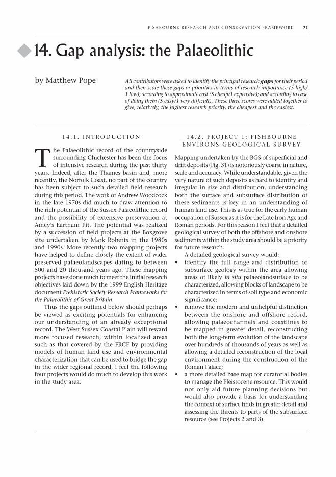
MappingundertakenbytheBgsofsuperficialanddriftdeposits(Fig.31)isnotoriouslycoarseinnature,scaleandaccuracy.Whileunderstandable,giventheverynatureofsuchdepositsashardtoidentifyandirregular in size anddistribution,understandingboth the surface and subsurface distribution ofthese sediments is key in an understanding ofhumanlanduse.thisisastruefortheearlyhumanoccupationofsussexasitisforthelateironageandromanperiods.Forthisreasonifeelthatadetailedgeologicalsurveyofboththeoffshoreandonshoresedimentswithinthestudyareashouldbeapriorityforfutureresearch.
adetailedgeologicalsurveywould:• identify the full range and distribution of
subsurface geology within the area allowingareasof likely in situ palaeolandsurface tobecharacterized,allowingblocksoflandscapetobecharacterizedintermsofsoiltypeandeconomicsignificance;
• removethemodernandunhelpfuldistinctionbetween the onshore and offshore record,allowing palaeochannels and coastlines tobe mapped in greater detail, reconstructingboththelong-termevolutionofthelandscapeoverhundredsofthousandsofyearsaswellasallowingadetailedreconstructionofthelocalenvironment during the construction of theromanpalace;
• amoredetailedbasemapforcuratorialbodiestomanagethepleistoceneresource.thiswouldnot only aid future planning decisions butwouldalsoprovideabasis forunderstandingthecontextofsurfacefindsingreaterdetailandassessingthethreatstopartsofthesubsurfaceresource(seeprojects2and3).
byMatthewpope
F ish Bourne research and conservation F ra MeWork 71
72 14 . gap analys is : the palaeolithic
• partofthisworkcouldbeusedtoidentifythesourceofbuildingmaterial,includingmasonryandroadsurface,forthepalaceandancillarystructures. the use of the lavant caves asromanquarries,thepresenceofbeachpebblesintheaggerasitcrossestheBoxgroveraisedbeach,andthepossiblequarryingontertiarylimestoneontheflanksoftheMixenholehaveallbeensuggested in thepast. such theoriescould be tested once and for all and eitherupheldorputtorest.
1 4 . 3 . p r o j e c t 2 : s u r F a c e F i n d sc o n t e x t c h a r a c t e r i z at i o n
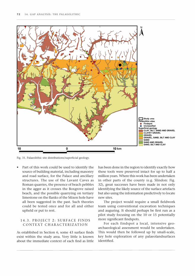
asestablishedinsection6,some43surfacefindsexistwithin the studyarea.very little is knownabouttheimmediatecontextofeachfindaslittle
hasbeendoneintheregiontoidentifyexactlyhowthesetoolswerepreservedintact foruptohalfamillionyears.Wherethisworkhasbeenundertakenin other parts of the county (e.g. slindon: Fig.32), great successeshavebeenmade innotonlyidentifyingthelikelysourceofthesurfaceartefactsbutalsousingtheinformationpredictivelytolocatenewsites.
the project would require a small fieldworkteam using conventional excavation techniquesandauguring.itshouldperhapsbefirstrunasapilotstudyfocusingonthe10or15potentiallymoresignificantfindspots.
For each findspot a local, intensive geo-archaeologicalassessmentwouldbeundertaken.this would then be followed up by small-scale,key hole exploration of any palaeolandsurfacesidentified.
Fig.31.palaeolithicsitedistributions/superficialgeology.
14 . gap analys is : the palaeolithic 73
1 4 . 4 . p r o j e c t 3 : s i t e - c o n d i t i o nc h a r a c t e r i z at i o n s u r v e y
ahugegapinourknowledgeexistsintheconditionandnaturalthreatofpartsofpreviouslyidentifiedpalaeolandsurface in the study area. there areperhaps12locationswithinthestudyareawherepalaeolandsurfaceorothercontextsknowntobepreserving in situarchaeologicalremainshavebeenidentifiedinareasofactivedevelopment,agricultureorsubaerialerosion.allofthesesitesfalloutsideofppg16guidelinesandhavenoprovisionfortheirassessmentormitigation.oneof these sites, thevaldoeQuarry,iscurrentlybeingsurveyedaspartofanalsFfundproject.thisproject,whichcombinessurfaceandgeophysicalsurveywithlocalmappingand test-pit excavation, couldperhaps form themodelforsuchexercises.
inessencethisprojectwouldproduceaseriesofconditionreportswithappendedsuggestionsformitigation,futuresitemanagementandresearch.
1 4 . 5 . c o M B i n at i o n p r o j e c t
ofcoursethepossibilityexiststovieweachofthesestand-alone projects as simply modules withina single combined detailed survey of findspots,onshore-offshore geology and site-conditionassessments. suchaprojectwouldbe large scale,longtermandexpensiveinnaturebutsuchcostscould be offset by undertaking the research inpartnership with ongoing pleistocene researchgroups in the regionandby looking for fundingfromtheaggregateslevysustainabilityFund,anappropriatesponsorgiventhelonghistoryofgravelextractionwithinthechichesterarea.
Fig.32.Bifacefromslindontypicalofsurfacefindsinthestudyarea.
table6.keypalaeolithicresearchprojects.
Palaeolithic projects
Research importance
Cost Ease Total
geologicalsurvey 4 3 4 11
surfacefinds 4 4 5 13
site-conditionsurvey 3 4 5 12
combinationproject 5 2 4 11


he analysis of the Mesolithic data in the Fishbourne Framework document has shown the diverse and fragmentary nature
of the records and archive. This means that further work will be initially required to draw together the existing information, and to enhance and complete the database, and thus provide a mean-ingful picture of the Mesolithic activity. Future research will then be guided to a great extent by the results of this exercise, but it has been possible to highlight some general areas for further research and fieldwork.
1 5 . 1 . G a p s i n T h e a r c h a e o l o G i c a l r e c o r d
The conclusion in the period summary identified some of the gaps in our current knowledge of the Mesolithic period in this area. These were summa-rized by area.
on the coastal plain the evidence to date sug-gests that there are numerous short-stay hunting camps and longer-stay base camps, frequently lo-cated alongside or near watercourses. The evidence needs to be re-evaluated to confirm the patterns that are emerging here, and to guide future strategies for fieldwork, especially relating to ppG16 work. in the Weald this same pattern is also emerging (e.g. holgate 1987; Butler forthcoming), and it may be possible to draw some conclusions and comparisons between further research in the Fishbourne Frame-work area, the Weald and elsewhere.
The chichester harbour area, and areas subject to coastal erosion, may be prime locale for future study as the potential for preserved in situ archae-ology, perhaps in anaerobic conditions, combined with the threat of its loss owing to erosion may produce some informative results. Further survey work around chichester harbour may provide suit-able data to allow comparisons with other recent work in inter-tidal zones, such as at langstone harbour (allen & Gardiner 2000) and the severn estuary (Bell 2006).
15. Gap analysis: the Mesolithic◆
T on the south downs, research elsewhere in sussex has shown that Mesolithic sites are clustered on the clay-with-flints outcrops. Further analysis of the existing findspots and sites, and any future work, such as fieldwalking, should perhaps be concentrated in these areas to establish whether this pattern is reflected here, and to establish the activities being undertaken on these sites. This can be compared with similar work undertaken to the north of Brighton (Butler 2001).
Further environmental work in all of these areas is also essential so that we can better understand the Mesolithic environment in which these hunter-gatherer groups were living.
1 5 . 2 . p o T e n T i a l i n e x c avaT i o n a r c h i v e s F o r F u r T h e r W o r k
Most of the sites listed on the sMr relate to single, or small groups of, artefacts, many of which may be in private hands or local museums, a full re-evaluation of these may not be possible, although many of the earlier finds will have been included in Wymer’s Gazetteer of Mesolithic Sites (1977).
an increasing number of sites have been dis-covered during the course of ppG16 work along the coastal plain, and in most cases the reports are available in the ‘grey literature’, and the archives should be accessible in local museums. however, in the majority of these cases the quantity of Meso-lithic material is small, and is derived from residual contexts. it is possible that a small number of sites remain unpublished, although it has not been pos-sible to identify these from the sMr information provided. it is clear that to gain a full picture of the state of the Mesolithic period data, a substantial amount of desk-based research will be required to revisit the excavation archives and ensure that all of the data has been collated.
The archive material should be available in a small number of local museums, but some site archives may still be held by contractor units, local societies or individual archaeologists.
by chris Butler
F i sh Bourne research and conservaTion Fra MeWork 75
76 15 . Gap analys is : The Mesoli Thic
1 5 . 3 . r e s e a r c h o p p o r T u n i T i e s a n d p r i o r i T i e s
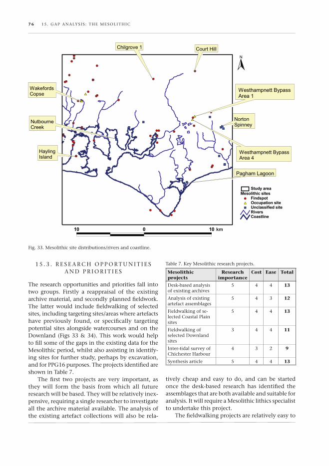
The research opportunities and priorities fall into two groups. Firstly a reappraisal of the existing archive material, and secondly planned fieldwork. The latter would include fieldwalking of selected sites, including targeting sites/areas where artefacts have previously found, or specifically targeting potential sites alongside watercourses and on the downland (Figs 33 & 34). This work would help to fill some of the gaps in the existing data for the Mesolithic period, whilst also assisting in identify-ing sites for further study, perhaps by excavation, and for ppG16 purposes. The projects identified are shown in Table 7.
The first two projects are very important, as they will form the basis from which all future research will be based. They will be relatively inex-pensive, requiring a single researcher to investigate all the archive material available. The analysis of the existing artefact collections will also be rela-
Fig. 33. Mesolithic site distributions/rivers and coastline.
Table 7. key Mesolithic research projects.
Mesolithic projects
Research importance
Cost Ease Total
desk-based analysis of existing archives
5 4 4 13
analysis of existing artefact assemblages
5 4 3 12
Fieldwalking of se-lected coastal plain sites
5 4 4 13
Fieldwalking of selected downland sites
3 4 4 11
inter-tidal survey of chichester harbour
4 3 2 9
synthesis article 5 4 4 13
tively cheap and easy to do, and can be started once the desk-based research has identified the assemblages that are both available and suitable for analysis. it will require a Mesolithic lithics specialist to undertake this project.
The fieldwalking projects are relatively easy to

15 . Gap analys is : The Mesoli Thic 77
arrange, and offer an opportunity for local societies and volunteers to get involved. a sole co-ordinator will be required to make the arrangements for the fieldwalking, and a lithics expert will be required to analyse the resulting material. The coastal plain fieldwalking has a higher priority owing to the large volume of development taking place here, which means that resources should be directed at this before attempting to carry out similar projects on the downs. an obvious by-product of the fieldwalk-ing is that artefacts from other periods will also be collected and thus can be linked to other research projects within the Framework. if volunteers are utilized for the fieldwalking, costs will be restricted to the co-ordinator and artefacts analysis.
an inter-tidal survey has a lower priority as one brief survey has already been conducted in the past (cartwright 1984). however, with the langstone harbour survey as a basis for a more intensive survey of chichester harbour, it is clear
Fig. 34. Mesolithic site distributions/superficial geology.
that there is potential for much more work in this area. This survey would require input and direction from a professional archaeological unit or university, although it may be possible to in-volve volunteers in the survey work. health and safety considerations will also need to be taken into account, and will result in this being a fairly expensive and complex option. as with the field-walking, this survey could also be multi-period and multi-disciplinary.
1 5 . 4 . c o n c l u s i o n
This section has identified five projects that form a framework for the re-analysis of the existing archive, and then resulting from that, the fieldwalking and survey work that can be undertaken, with a sixth item being the publication of the results in a major re-appraisal of the Mesolithic period. They are listed in the table in the order of priority in which they

78 15 . Gap analys is : The Mesoli Thic
should be carried out. This should be seen as a first stage in filling the gaps in our knowledge of the Mesolithic in the Fishbourne Framework area, and
will then provide an enhanced database of evidence that can then provide direction for any subsequent fieldwork projects.
Fig. 35. hayling island foreshore, a typical location for Mesolithic sites.
1 6 . 1 . D at i n g
lthough the neolithic spans some 1500 years there is little precision in the dat-ing of the material within the Fishbourne
Research and Conservation Framework study area. there are three neolithic C14 dates from the trundle (two new ones from the current University of Cardiff project, although apparently from neo-lithic contexts, were dated to the first millennium bc), one from Bevis’s thumb and two from north Marden. More C14 dates are clearly needed but currently there is no archival material that can be dated. a programme of targeted sampling to obtain new C14 dates could be considered.
1 6 . 2 . E n v i R o n M E n t
although there is limited environmental data (molluscan analysis) from the trundle and north Marden, little detailed data relating to the neolithic is available from the Downland area of the study block. a programme of dry valley sections of the type undertaken by Bell, allen and Wilkinson to the east in the Brighton–Eastbourne Downland block could be considered to enhance the environ-mental data within the FRCF study area.
Perhaps more important would be a study of the environmental context of the Coastal Plain within the study area (Fig. 36). this is, however, more problematic. Suitable deposits, possibly of peat, would have to be located and these are most likely to be located through PPg16 opportunities. the Chichester Harbour archaeological Research Framework recommended systematic coring of the aonB. Such a programme could be extended within this Framework area.
1 6 . 3 . S E t t l E M E n t
the nature of neolithic ‘settlement’ remains prob-lematic in southern England. Houses or house-like structures (as found at the White Horse Stone site in the Medway valley, Kent) are elusive and
16. Gap analysis: the Neolithic◆
alikely only to be found under deep colluvium so are most likely to be located through PPg16 op-portunities.
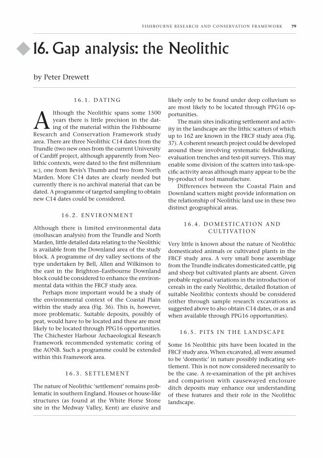
the main sites indicating settlement and activ-ity in the landscape are the lithic scatters of which up to 162 are known in the FRCF study area (Fig. 37). a coherent research project could be developed around these involving systematic fieldwalking, evaluation trenches and test-pit surveys. this may enable some division of the scatters into task-spe-cific activity areas although many appear to be the by-product of tool manufacture.
Differences between the Coastal Plain and Downland scatters might provide information on the relationship of neolithic land use in these two distinct geographical areas.
1 6 . 4 . D o M E S t i C at i o n a n D C U lt i vat i o n
very little is known about the nature of neolithic domesticated animals or cultivated plants in the FRCF study area. a very small bone assemblage from the trundle indicates domesticated cattle, pig and sheep but cultivated plants are absent. given probable regional variations in the introduction of cereals in the early neolithic, detailed flotation of suitable neolithic contexts should be considered (either through sample research excavations as suggested above to also obtain C14 dates, or as and when available through PPg16 opportunities).
1 6 . 5 . P i t S i n t H E l a n D S C a P E
Some 16 neolithic pits have been located in the FRCF study area. When excavated, all were assumed to be ‘domestic’ in nature possibly indicating set-tlement. this is not now considered necessarily to be the case. a re-examination of the pit archives and comparison with causewayed enclosure ditch deposits may enhance our understanding of these features and their role in the neolithic landscape.
by Peter Drewett
F i SHB oUR nE RESE aRCH an D Con SERvation FR aMEW oRK 79

80 16 . ga P analy S iS : t HE n Eolit HiC
1 6 . 6 . P o t E n t i a l F o R F U t U R E W o R K B a S E D o n E x i S t i n g E x C ava -
t i o n a R C H i v E S
there are very few existing archives based on neolithic excavations in the survey area. Re-evalu-ation of pit groups should be considered. archived material from lithic scatters in local museums or private hands has potential for the identification of defined activity areas. Much of this material was not, however, systematically collected and many early find locations are not precise.
1 6 . 7 . R E S E a R C H o P P o R t U n i t i E S a n D P R i o R i t i E S
the main gaps in our knowledge of the neolithic in the FRCF study area relate to the environment, the nature of ‘settlement’ in its widest sense and
Fig. 36. neolithic site distributions/rivers and coastline.
the relationship between activities on the Coastal Plain and the Downs. although essentially a re-gional study it has both national and international importance in our understanding of regionality in the neolithic of both southern England and northwest Europe. the projects identified are shown in table 8.
the environmental programme is the most important of those identified as an understanding of activity on the Coastal Plain in particular must be bedded in a sound environmental context. this is probably equally important for all prehistoric periods under study in the Framework. this is closely followed by an attempt at more precise dating within the neolithic. Both of these projects are, however, expensive, and require specialists in the fields. Re-analysis of existing lithic scatters and fieldwalking of selected sites on the Coastal Plain are relatively cost effective and easy to undertake
16 . ga P analy S iS : t HE nE olit HiC 81
Fig. 37. neolithic site distributions/superficial geology.
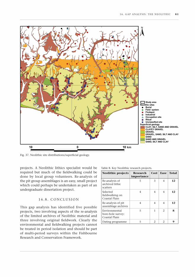
table 8. Key neolithic research projects.
Neolithic projects Research importance
Cost Ease Total
Re-analysis of archived lithic scatters
5 3 4 12
Selected fieldwalking on Coastal Plain
4 4 4 12
Re-analysis of pit assemblage archives
4 4 4 12
Environmental bore-hole survey: Coastal Plain
5 1 2 8
Dating programme 5 2 2 9
projects. a neolithic lithics specialist would be required but much of the fieldwalking could be done by local group volunteers. Re-analysis of the pit group assemblages is an easy, small project which could perhaps be undertaken as part of an undergraduate dissertation project.
1 6 . 8 . C o n C l U S i o n
this gap analysis has identified five possible projects, two involving aspects of the re-analysis of the limited archives of neolithic material and three involving original fieldwork. Clearly the environmental and fieldwalking projects cannot be treated in period isolation and should be part of multi-period surveys within the Fishbourne Research and Conservation Framework.
km
82 16 . ga P analy S iS : t HE n Eolit HiC
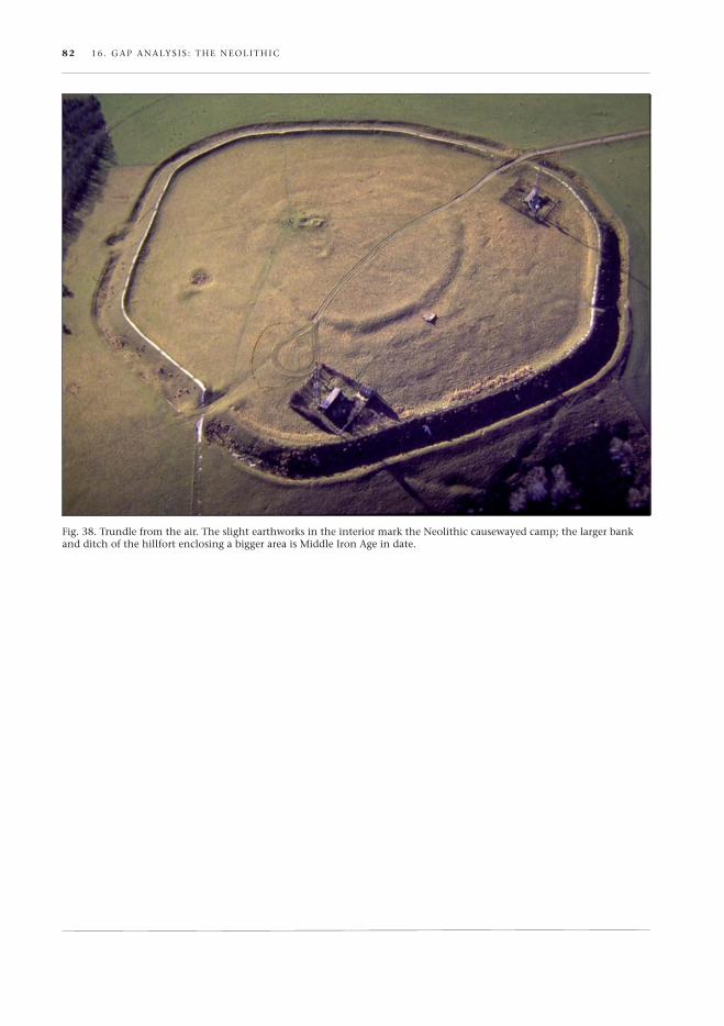
Fig. 38. trundle from the air. the slight earthworks in the interior mark the neolithic causewayed camp; the larger bank and ditch of the hillfort enclosing a bigger area is Middle iron age in date.

he research agenda listed below provides a framework for investigating the dyna-mism of the Bronze Age at the local level.
It concentrates on the pace of land clearance; how settlement and land enclosure relate to earlier monuments; the nature of the political economies; and, evidence for social dislocation, at the end of the Bronze Age.
1 7 . 1 . D e t e r m I n I n g t h e pA c e o f m A r I n e t r A n s g r e s s I o n D u r I n g t h e B r o n z e A g e A n D r e s u ltA n t
A lt e r At I o n s I n c o A s tA l D r A I n A g e pAt t e r n s
A model of coastal and land changes can suggest where artefacts may be preserved under marine or alluvial sediments (particularly in the chichester and pagham estuaries) or might have been de-stroyed by tidal erosion (fig. 39 & 40). Did rising sea levels have an effect on agricultural ‘intensification’ on the coastal plain during the period? It would be important to map relative sea-level changes and to adopt the ‘seamless’ approach, as advocated by tomalin (2000) in which the on-shore, inter-tidal and sub-tidal zones are treated as an entity.
1 7 . 2 . A s s e s s I n g t h e o n s e t, s c A l e A n D I n t e n s I t y o f h u m A n
e x p l o I tAt I o n o f c o A s tA l , D o w n l A n D A n D w e A l D e n
n At u r A l r e s o u r c e s
the degree to which communities relied on ma-rine resources is little understood. extending the langstone inter-tidal research (Allen & gardiner 2000) to the chichester harbour area should be a research priority. the onset of agriculture and resultant erosion of the loess on the Downs could be further investigated with emphasis placed on well-dated samples of bioarchaeological material. A priority for investigation must be colluvial and
17. Gap analysis: the Bronze Age◆
t alluvial sequences (Allen 2005) complemented by information drawn from broader environmental work, such as that derived from the pollen record. recording of sedimentary sequences in the river valleys of the ems and lavant should be a prelimi-nary starting point. the brick-earths have sparse archaeobotanical and environmental remains. It is therefore crucial that when sites are identified a full and extensive range of environmental and artefactual sampling is undertaken. the Alding-bourne and ryebank rifes in particular have much potential for palaeoenvironmental research. the potential for off-site sampling should be explored wherever possible in commercial projects. Inves-tigation of resource exploitation should not be confined to the fertile soils of the coastal low-lands and the Downland block. research might usefully focus on the greensand ridge (on the northern fringes of the study area) forming the rim of the wealden basin. this is a zone often in the shadow of major barrow cemeteries on the Downland skyline. the discovery of early first-millennium bc land division and settlement at Kingsley to the west (wessex Archaeology 1988) and at storrington to the east of the study area (howard-Davis & matthews 2002) together with putative roundhouse structures at Bignor suggest that more settlement and land holdings may be found on the greensand ridge.
1 7 . 3 . I m p r o v I n g c h r o n o l o g I c A l p r e c I s I o n
A major obstacle to our understanding of the change from the monument-dominated land-scape of the neolithic and early Bronze Age to the settlement-dominated landscape is the poor chronological resolution. frequently, it is impos-sible to resolve the dating of different phases of monument construction and subsequent land division. the remedy is that radiocarbon dating becomes routine.
by David Dunkin & David yates
f I sh Bourne rese Arch AnD conservAtIon fr Amewor K 83
84 17 . g Ap AnAlys Is : the Bronze Age
1 7 . 4 . D e v e l o p A s c h e m At I c m o D e l o f I n t e r A c t I o n A l o n g
t h e c o A s t, c r o s s c h A n n e l A n D I n l A n D
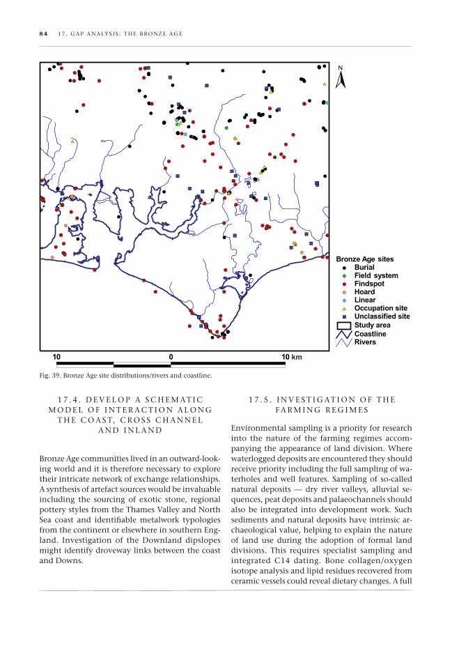
Bronze Age communities lived in an outward-look-ing world and it is therefore necessary to explore their intricate network of exchange relationships. A synthesis of artefact sources would be invaluable including the sourcing of exotic stone, regional pottery styles from the thames valley and north sea coast and identifiable metalwork typologies from the continent or elsewhere in southern eng-land. Investigation of the Downland dipslopes might identify droveway links between the coast and Downs.
fig. 39. Bronze Age site distributions/rivers and coastline.
1 7 . 5 . I n v e s t I g At I o n o f t h e f A r m I n g r e g I m e s
environmental sampling is a priority for research into the nature of the farming regimes accom-panying the appearance of land division. where waterlogged deposits are encountered they should receive priority including the full sampling of wa-terholes and well features. sampling of so-called natural deposits — dry river valleys, alluvial se-quences, peat deposits and palaeochannels should also be integrated into development work. such sediments and natural deposits have intrinsic ar-chaeological value, helping to explain the nature of land use during the adoption of formal land divisions. this requires specialist sampling and integrated c14 dating. Bone collagen/oxygen isotope analysis and lipid residues recovered from ceramic vessels could reveal dietary changes. A full

17 . g Ap AnAlys Is : the Bronze Age 85
fig. 40. Bronze Age site distributions/superficial geology.
research-driven excavation of burnt mound sites deploying geophysics and lithic collection in the immediate environs would enable important char-acteristics of the later Bronze Age landscape to be evaluated. A further research question is to address the extent of integration of the farming regimes on the Downland and the coastal plain.
1 7 . 6 . I D e n t I f y I n g pAt t e r n s I n t h e g r I D D e D l A n D s c A p e
In a sense the discovery of rectilinear fields and enclosures on the coastal plain and Downlands is the easy part. Deciphering the subtleties of these land blocks is the next challenge. In the early days of excavation in southern england, interest focused on the ditched borders rather than the ‘dead ground’ that they surrounded. the increasing discovery of human bones within the
Bronze Age fields, however, makes that term ‘dead ground’ more meaningful. the incorporation of human skeletal remains as a constituent of the cultural soils, suggests a richness for those ‘empty’ spaces previously unknown. It immediately has implications for wholesale topsoil stripping and the need for micromorphological work to fully explore the nature of the worked soils. this is just one subtlety now becoming apparent. these large terrain landscapes are highly regulated and built in conformity to prescribed rules of alignment — incorporating metalwork depositions (fig. 41), curated objects, burnt mounds and settlement. the long-term research aim must be to piece together each find site in order to chart the orientation of the coaxial grids; evidence of standardization of field plots; the role of integrated droveways; any phased change in land tenure; and evidence of settlement hierarchies. the plotted pattern

86 17 . g Ap AnAlys Is : the Bronze Age
can then be compared with historic maps (e.g. yeakell & gardiner 1778–83) to detect whether prehistoric boundaries became fossilized in the countryside. these organized landscapes are also beginning to reveal the disciplined nature of their construction. the ditch profiles, when examined in several sections suggest gang working and in-cremental building phases. topographical survey accompanied by augering, should be undertaken to formulate predictive models, e.g. possible locations of potterne type middens (lawson 2000).
1 7 . 7 . r e - e x A m I n At I o n o f w o o D l A n D s o n t h e
s o u t h D o w n s
the Downlands to the immediate north of fish-bourne include some of the most densely wooded stretches of downland. In consequence they have been largely ignored in archaeological investiga-tion, even though some of the ancient woodlands may preserve the last remnants of prehistoric Downland landscape. recent breakthroughs in air reconnaissance provide a new opportunity to re-examine the monuments and field-system evidence. lIDAr (light Detection and ranging) is one advance in aerial photographic survey which provides for the first time highly detailed and accurate models of the land surface at metre and sub-metre resolution. the technique provides the ability to survey slight earthworks hidden by tree canopies (Devereux et al. 2005) and could be used to explore a transect from fishbourne northwards
to the foot of the Downland escarpment. that research zone would enable a re-examination of Kingley vale, Bow hill and oxen Down. All are rich in Bronze Age monuments and the results might reveal the relationship between monument construction and land tenure.
1 7 . 8 . I n v e s t I g At I o n o f s o c I A l D I s l o c At I o n D u r I n g t h e l At e
B r o n z e A g e / e A r ly I r o n A g e t r A n s I t I o n
the widespread abandonment of rectilinear field systems and associated waterholes throughout southern england suggests a degree of systems col-lapse at the end of the Bronze Age. An examination into the changing patterns of cross-channel trade and settlement patterns during this apparent hia-tus, at the local and regional level, is an important research goal.
fig. 41. west Ashling middle Bronze Age spearheads.
table 9. Key Bronze Age research projects.
Bronze Age projects
Research importance
Cost Ease Total
Determining pace of marine transgression and coastal morphology changes
4 3 2 9
Assessing onset, scale and intensity of human exploitation of natural resources across the topographical units
5 2 2 9
Improving chronological precision
5 2 4 11
Develop a schematic model of interaction along the coast, cross channel and inland
4 2 3 9
Investigation of the farming regimes
4 3 3 10
Identifying patterns in the gridded landscape
4 2 4 10
re-examination of woodlands on the south Downs
4 1 2 7
Investigation of social dislocation during the late Bronze Age/early Iron Age transition
5 3 4 12