galactic super storms 2009-10
DESCRIPTION
About the likelihood of Super Storms, of one hitting Hong Kong, of the increased likelihood in 2010 when the Nodes of the Moon join the Galactic axis, and Mercury forms a T square. Super-typhoons, galactic size storms, may be on the way as the Galactic Centre prepares to birth a new Earth. Which areas of the Earth are most endangered?TRANSCRIPT

SUPER STORMS IN AUGUST-SEPTEMBER-
OCTOBER 2009?A Holy Cross involving the Galactic Centre, Mercury,
and the Nodes of the Moon
Pictures show the similarity between the formation of storms-hurricanes-and galaxies
During the Christmas holidays 2006 I watched a film about the Tsunami called The Aftermath followed by a documentary drama entitled Perfect Disaster: Supertyphoon. The documentary film was more terrible than the film about the Tsunami „ It was about a super typhoon hitting Hong Kong, and its likely effects.
In this scenario the huge population living in their towering glass skyscrapers would find no escape when the winds broke the glass and sucked them out. The disaster was fantasized to occur on a 13th September, no year was suggested.
I looked up the coming years and found that September 13 2009 looked quite possible for a large storm because Mercury, the planet most associate with disturbances of the air, would be involved in a grand cross that also included Uranus (the higher octave of the airy planet Mercury). Also on this date the air signs were involved.
Below you see in the chart that Mercury is in the air sign Libra square Mars and Pluto. On the 13th September the Moon will move into Cancer and join Mars there more directly involving Mercury in the grand cross. The positioning of Moon and Mars in Cancer suggests the worst part of a storm could involve the Cancer zone, which is Asia, though

there are planetary involvements in the New Zealand and Atlantic Zones. Anyway, it suggests the possibility of a supertyphoon.
CHART FOR 12th September 2009 – A Stormy period?
Yet there is one thing missing on 12th to 13th September that is suggestive of a super storm and that is a strong aspect involving the Nodes of the Moon aspecting the air signs or planets. By Cyclone Nargis, that occurred on May 2nd 2008 and caused the deaths of c.150,000 people, maybe more, Mercury was square the Nodes and a bow and arrow pointed also at Mercury.
CYCLONE
NARGIS
2008
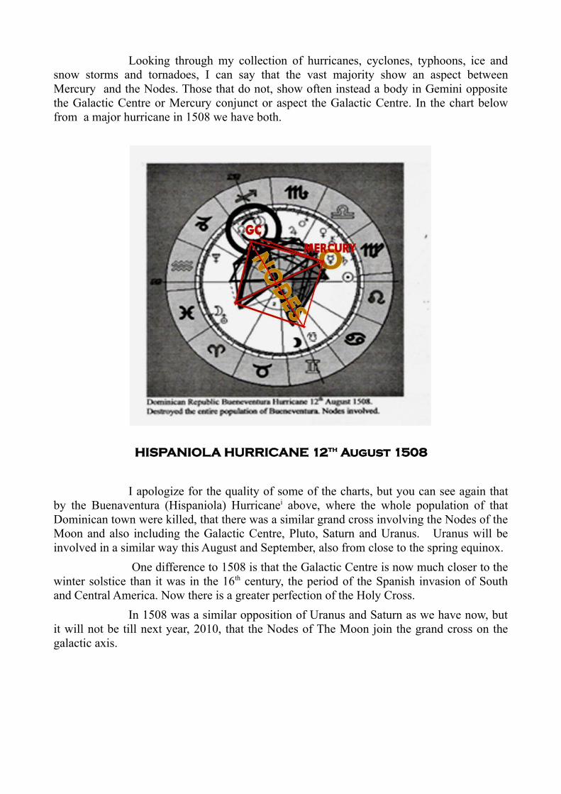
Looking through my collection of hurricanes, cyclones, typhoons, ice and snow storms and tornadoes, I can say that the vast majority show an aspect between Mercury and the Nodes. Those that do not, show often instead a body in Gemini opposite the Galactic Centre or Mercury conjunct or aspect the Galactic Centre. In the chart below from a major hurricane in 1508 we have both.
HISPANIOLA HURRICANE 12th August 1508
I apologize for the quality of some of the charts, but you can see again that by the Buenaventura (Hispaniola) Hurricanei above, where the whole population of that Dominican town were killed, that there was a similar grand cross involving the Nodes of the Moon and also including the Galactic Centre, Pluto, Saturn and Uranus. Uranus will be involved in a similar way this August and September, also from close to the spring equinox.
One difference to 1508 is that the Galactic Centre is now much closer to the winter solstice than it was in the 16th century, the period of the Spanish invasion of South and Central America. Now there is a greater perfection of the Holy Cross.
In 1508 was a similar opposition of Uranus and Saturn as we have now, but it will not be till next year, 2010, that the Nodes of The Moon join the grand cross on the galactic axis.
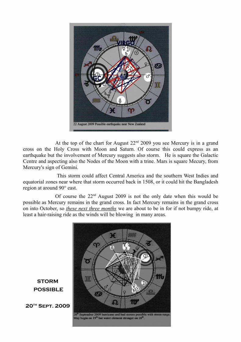
At the top of the chart for August 22nd 2009 you see Mercury is in a grand cross on the Holy Cross with Moon and Saturn. Of course this could express as an earthquake but the involvement of Mercury suggests also storm. He is square the Galactic Centre and aspecting also the Nodes of the Moon with a trine. Mars is square Mecury, from Mercury's sign of Gemini.
This storm could affect Central America and the southern West Indies and equatorial zones near where that storm occurred back in 1508, or it could hit the Bangladesh region at around 90° east.
Of course the 22nd August 2009 is not the only date when this would be possible as Mercury remains in the grand cross. In fact Mercury remains in the grand cross on into October, so these next three months we are about to be in for if not bumpy ride, at least a hair-raising ride as the winds will be blowing in many areas.
STORM
POSSIBLE
20th Sept. 2009

Mercury turns retrograde and is back again conjunct Saturn in Virgo with the Sun in the above chart of 20th September 2009. Of course Saturn can also mean earthquakes but here will also try his hand at storms, especially when aspecting Mercury or Uranus, Saturn is the Master Craftsman.
On the 9th October 2009 there is another grand cross involves Mercury even though Mars has moved on.
At the turn to the 20th Century, on 8th September, a grand cross formed as Pluto was opposite the Galactic Centre. It too was on the Holy Cross that was not as strongly on the solstice equinox axes as it is nowadays.
Galvestone was the worst ever hurricane, at least the most deadly, to ever hit the United States, in fact it was the worst disaster at all to ever hit the United States. It hit at
94° West which is one of my endangered zones. These are the 90° west and 90° east longitudes. (This is mentioned in other articles on scribd about August 2009)
Next year, 2010, when Mercury transits Virgo and early Libra it will square the Nodes. That will produce truly memorable storms.
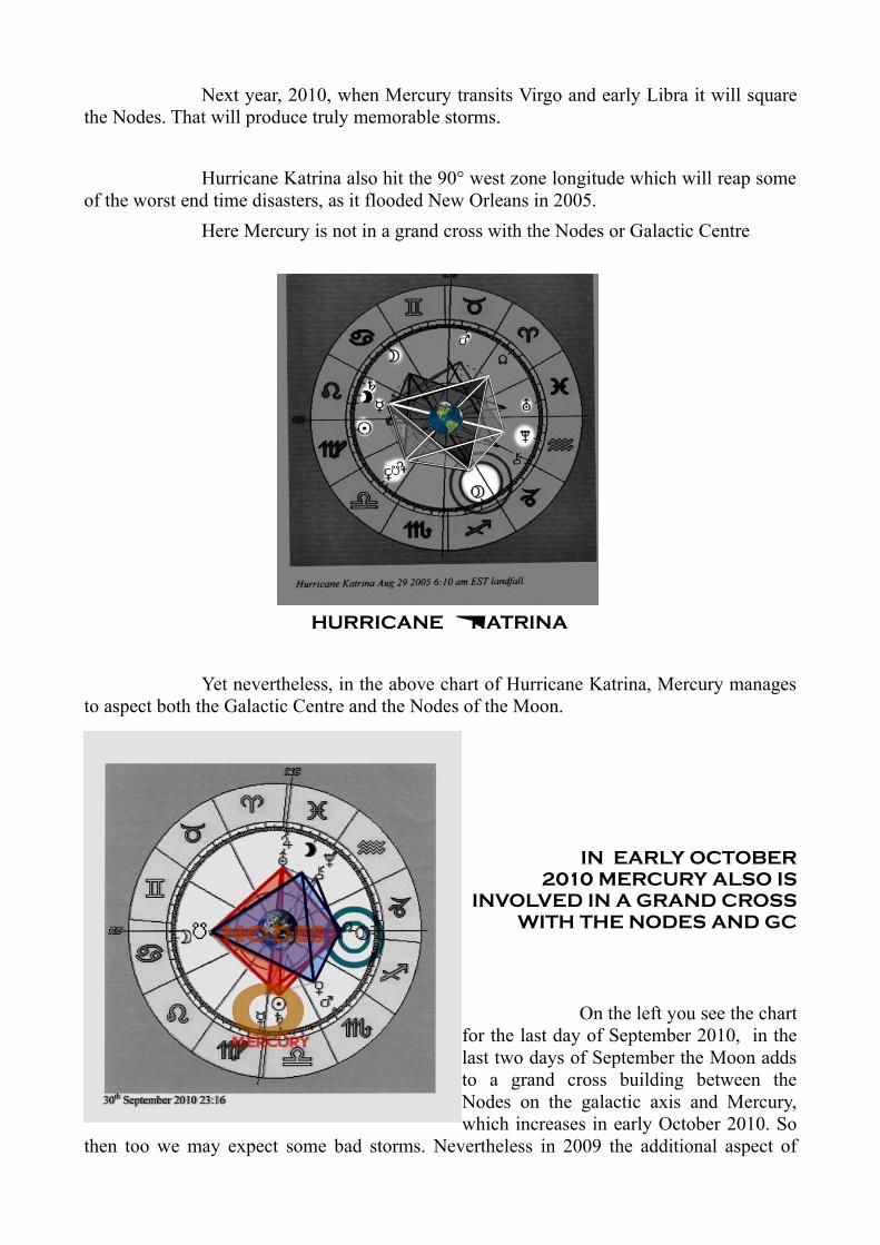
Hurricane Katrina also hit the 90° west zone longitude which will reap some of the worst end time disasters, as it flooded New Orleans in 2005.
Here Mercury is not in a grand cross with the Nodes or Galactic Centre
HURRICANE KATRINA
Yet nevertheless, in the above chart of Hurricane Katrina, Mercury manages to aspect both the Galactic Centre and the Nodes of the Moon.
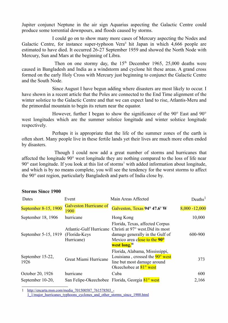
IN EARLY OCTOBER 2010 MERCURY ALSO IS
INVOLVED IN A GRAND CROSS WITH THE NODES AND GC
On the left you see the chart for the last day of September 2010, in the last two days of September the Moon adds to a grand cross building between the Nodes on the galactic axis and Mercury, which increases in early October 2010. So
then too we may expect some bad storms. Nevertheless in 2009 the additional aspect of
Jupiter conjunct Neptune in the air sign Aquarius aspecting the Galactic Centre could produce some torrential downpours, and floods caused by storms.
I could go on to show many more cases of Mercury aspecting the Nodes and Galactic Centre, for instance super-typhoon Veraii hit Japan in which 4,666 people are estimated to have died. It occurred 26-27 September 1959 and showed the North Node with Mercury, Sun and Mars at the beginning of Libra.
Then on one stormy day, the 15th December 1965, 25,000 deaths were caused in Bangladesh and India as a windstorm and cyclone hit these areas. A grand cross formed on the early Holy Cross with Mercury just beginning to conjunct the Galactic Centre and the South Node.
Since August I have begun adding where disasters are most likely to occur. I have shown in a recent article that the Poles are connected to the End Time alignment of the winter solstice to the Galactic Centre and that we can expect land to rise, Atlantis-Meru and the primordial mountain to begin its return near the equator.
However, further I began to show the significance of the 90° East and 90° west longitudes which are the summer solstice longitude and winter solstice longitude respectively.
Perhaps it is appropriate that the life of the summer zones of the earth is often short. Many people live in these fertile lands yet their lives are much more often ended by disasters.
Though I could now add a great number of storms and hurricanes that affected the longitude 90° west longitude they are nothing compared to the loss of life near 90° east longitude. If you look at this list of storms1 with added information about longitude, and which is by no means complete, you will see the tendency for the worst storms to affect the 90° east region, particularly Bangladesh and parts of India close by.
Storms Since 1900Dates Event Main Areas Affected Deaths1
September 8-15, 1900 Galveston Hurricane of 1900 Galveston, Texas 94° 47.6' W 8,000 -12,000
September 18, 1906 hurricane Hong Kong 10,000
September 5-15, 1919 Atlantic-Gulf Hurricane(Florida-Keys Hurricane)
Florida, Texas, affected Corpus Christi at 97° west.Did its most damage generally in the Gulf of Mexico area close to the 90° west long.iii
600-900
September 15-22, 1926 Great Miami Hurricane
Florida, Alabama, Mississippi, Louisiana , crossed the 90° west line but most damage around Okeechobee at 81° west
373
October 20, 1926 hurricane Cuba 600 September 10-20, San Felipe-Okeechobee Florida, Georgia 81° west 2,166
1 http://encarta.msn.com/media_701500587_761578503_- 1_1/major_hurricanes_typhoons_cyclones_and_other_storms_since_1900.html

1928 Hurricane September 3, 1930 hurricane Dominican Republic 2,000 September 1-10, 1935 Labor Day Hurricane Florida 408 September 13-22, 1938 New England Hurricane Long Island, Connecticut,
Massachusetts 600
November 11-12, 1940 blizzard
northeastern and midwestern United States . Deaths along Mississippi close to 90° west and at Lake Michigan 87° west – 66 sailors died.
144 (wiki gives 154)
October 16, 1942 cyclone India 40,000
September 9-16, 1944 Great Atlantic Hurricane East Coast from North Carolina to Maine 390
December 26, 1947 blizzard New York and North Atlantic states, United States
55
March 21-22, 1952 tornadoes
southern United States crossed 90° west long.worst number of deaths at 91°38′17″W Judsonia.
343
October 22, 1952 typhoon Philippines 440 May 11, 1953 tornado Waco, Texas 97° west long. 114 June 8, 1953 tornado Flint, Michigan 116 August 25-31, 1954 Hurricane Carol North Carolina and New England 60 September 7-11, 1954 Hurricane Edna northeastern United States 20 October 5-15, 1954 Hurricane Hazel Carolinas, Virginia 600-1,200
August 5-14, 1955 Hurricane Connie North Carolina, Virginia, Maryland 0
August 11-21, 1955 Hurricane Diane North Carolina north to Massachusetts 184
February 1-29, 1956 blizzard Europe 1,000
June 25-29, 1957 Hurricane Audrey
Texas and Louisiana actually moved along the 90° west line causing tornadoes at New Orleans (see wikiiv) at 90°04' west also hit Bridge City at 93° west.
390
February 5-16, 1958 blizzard northeastern United States 171 September 17-19, 1959 Typhoon Sarah Japan and South Korea 2,000
September 26-27, 1959 Typhoon Vera Japan 4,466
September 1-13, 1960 Hurricane Donna eastern United States 164 October 10, 1960 cyclone Bay of Benghal 90° east 6,000 September 11-14, 1961 Hurricane Carla Texas 46 October 31, 1961 Hurricane Hattie British Honduras 400 May 28-29, 1963 cyclone Bangladesh 90° east 22,000 October 4-8, 1963 Hurricane Flora Caribbean 6,000
June 30, 1964 Typhoon Winnie northern Philippines 107 September 5, 1964 Typhoon Ruby Hong Kong/China 735
April 11, 1965 tornadoes midwestern United States.Worst at Twin Cities 93° west long.
256
May 11-12, 1965 cyclone Bangladesh 90° east 17,000 June 1-2, 1965 cyclone Bangladesh 90° east 30,000 August 27-September 14, 1965 Hurricane Betsy Bahamas/southeastern United
States 76
December 15, 1965 cyclone
3rd cyclone of year kills another 15,000 at mouths of Ganges River1965 : Bangladesh windstormv kills 10,000
10,000
15,000
June 4-10, 1966 Hurricane Alma Honduras/eastern United States 51 September 24-30, 1966 Hurricane Inez Caribbean/Mexico/southeastern
United States (90° west) 293
July 9, 1967 Typhoon Billie southwestern Japan 347
September 5-23, 1967 Hurricane Beulah Caribbean/Mexico/Texas, United States 54
December 12-20, 1967January 26 1967
blizzard Chicago Blizzard vi
southwestern United States Chicago 88° west 51
November 18-20, 1968 Typhoon Nina Philippines 63
August 17-18, 1969 Hurricane Camille Louisiana and Mississippi, United States 90° west 256
July 30-August 5, 1970 Hurricane Celiavii
Cuba / Florida and Texas, United States. Worst damages in Texas close to 90° west, Corpus Christi etc.
31
August 20-21, 1970 Hurricane Dorothy Martinique 42 September 15, 1970 Typhoon Georgia Philippines 300 October 14, 1970 Typhoon Sening Philippines 583 October 15, 1970 Typhoon Titang Philippines 526 November 12-13, 1970 cyclone Bangladesh 90° east >300,000
August 1, 1971 Typhoon Rose Hong Kong 130
September 29, 1971 cyclone Orissa State, India 85° east longitude 10,000-25,000
June 19-29, 1972 Hurricane Agnes eastern United States 122 December 3, 1972 Typhoon Theresa Philippines 169 April 3-4, 1974 tornadoes eastern, southern, and
midwestern United States.Interesting here is that mid America at 90° west is St.Louis, that has been hit by lethal cyclones and tornadoes quite often. Also on 90° west of course
315
New Orleans hit by Katrina etc
June 11, 1974 Typhoon Dinah Luzon, Philippines 71 July 11, 1974 Typhoon Gilda Japan/South Korea 108 September 19-20, 1974 Hurricane Fifi Honduras 2,000
December 25, 1974 cyclone Darwin, Australia 50 September 13-27, 1975 Hurricane Eloise Caribbean/northeastern United
States 71
May 20, 1976 Typhoon Olga Philippines 215 July 25, 31, 1977 typhoons, Thelma, Vera Taiwan 39
November 19, 1977 cyclone Andhra Pradesh, India reaches to 84°40'E longitude 20,000
October 27, 1978 Typhoon Rita Philippines >400 August 30-September 7, 1979 Hurricane David Caribbean/eastern United States 1,100
August 4-11, 1980 Hurricane Allen Caribbean/Texas, United States 272 November 25, 1981 Typhoon Irma Luzon, Philippines 176 August 18, 1983 Hurricane Alicia southern Texas, United States 21 September 2, 1984 Typhoon Ike southern Philippines 1,363
May 25, 1985 cyclone Bangladesh sits at 90° 00' East 10,000
October 26-November 6, 1985 Hurricane Juan southeastern United States 63
November 25, 1987 Typhoon Nina Philippines 650 September 10-17, 1988 Hurricane Gilbert Gulf of Mexico /Caribbean
partly in 90° west 260
September 10-22, 1989 Hurricane Hugo Caribbean/United States 86
March 12-18, 1990 storms Bangladesh 90° east 242 May 6-11, 1990 cyclone India 514 June 1990 typhoons Philippines 156 July-August 1990 typhoons China 1,802 November 1990 typhoons/storm Philippines 1,312 April 30, 1991 cyclone Bangladesh 90° east 138,866 May 12, 1991 storm Philippines 3,956 June 10, 1991 cyclone Bangladesh 90° east 125,720 February 15, 1992 cyclone Vietnam 251
August 23-26, 1992 Hurricane Andrewviii
southern Florida and Louisiana, United States. Also looped over the 90° west long. So crossing it twice.
74
March 13-14, 1993 blizzard eastern United States 270 May 2, 1994 cyclone southeastern Bangladesh 90° east 165 August 22, 1994 Typhoon Fred Zhejiang Province, China >710
October 31-November 3, 1994 cyclone India ? 260
November 8-18, 1994 storm Caribbean; Florida, United States 830 January 23, 1995 snowstorms Kashmir >200 September 5-7, 1995 Hurricane Luis Caribbean 14 November 2-3, 1995 Typhoon Angela Philippines 700 May 13, 1996 tornado Bangladesh 90° east >600
June 15-16, 1996 cyclone
southeastern India looking up cyclones for 1996 many moved to or along the 90° east line.ix
120
July 27-28, 1996 Hurricane Cesar Panama, El Salvador, Costa Rica 62 July 31-August 1, 1996 Typhoon Herb Taiwan 400
September 5-6, 1996 Hurricane Fran North Carolina and Virginia, United States 34
September 9, 1996 Typhoon Sally southern China 145 November 4, 1996 cyclone Andhra Pradesh, India >1,000 January 4-5, 1997 storms Brazil 68 May 19-20, 1997 cyclone Bangladesh 90° east 100 August 18, 1997 Typhoon Winnie China 140 September 27, 1997 cyclone Bangladesh 90° east >45 October 9, 1997 Hurricane Pauline Pacific coast of Mexico 400 May 20, 1998 cyclone Pakistan 250 June 9, 1998 cyclone Gujarat, western India 1,000
September 22-29, 1998 Hurricane Georges
Dominican Republic, Haiti, Puerto Rico, southeastern United States
>375
October, 1998 Typhoons Zeb and Babs Philippines 270
October 28, 1998 Hurricane Mitch Honduras. Mitch travelled twice over 90° west line 7,000
November, 1998 three storms Vietnam 267 October 29, 1999 Cyclone eastern India >9,000
June 5-17, 2001 Tropical Storm Allison x
Gulf Coast and eastern United States. Worst damage around Houston (95° west ) and Galveston, Texas.Travelled over and along 90° west.
41
May 1-10, 2001 tornadoes southern and midwestern United States 42
December 8, 2002 Typhoon Pongsana Guam and Mariana Islands >40 September 12-14, 2003 Typhoon Maemi southern South Korea 87
July 4-13, 2005 Hurricane Dennis Haiti and Cuba 42
August 23-30, 2005 Hurricane Katrina southeastern United States New Orleans 90° west 1,500

September 17-26, 2005 Hurricane Rita xi
Texas and Louisiana, United States. Crossed 90° west twice,moving down it a while.
7
October 15-25, 2005 Hurricane Wilma Cuba; Florida, United States 23
May 2, 2008 Cyclone Nargis Myanmar (twice crossed 90° east but missed Bangladesh) >138,0002
1Death tolls are estimates. 2Includes dead and missing.
Adapted list from source in footnote gives the result that around 741,000 people have died through some kind of storm or cyclone in the Bay of Bengal /Bangladesh Ganges delta area since 1900, which is hundreds of thousands more than anywhere else in the world!
As to the reason why the solstice areas are more affected that is dealt with in other articles but is largely to do with the position of the galactic axis alignment with the solstice axis at this time, the End Time. These storms at the solstice zones also occurred as heavenly bodies passed over the solstice areas of the atrological charts or squared the galactic axis.
Of course, more than suggesting which areas are particularly endangered in the coming years, this map points to the question: do we live on a planned Earth? An Earth created according to a plan we havnt recognized? One could further postulate as to the significance of these two disaster areas being at the delta area of two great rivers the Ganges and the Mississippi, one could call these bays, that the rivers flow into, womb like. Both these rivers have been seen as reflections of the Milky Way, and the womb of the Milky Way, now aligned with the winter solstice, is the Galactic Centre.
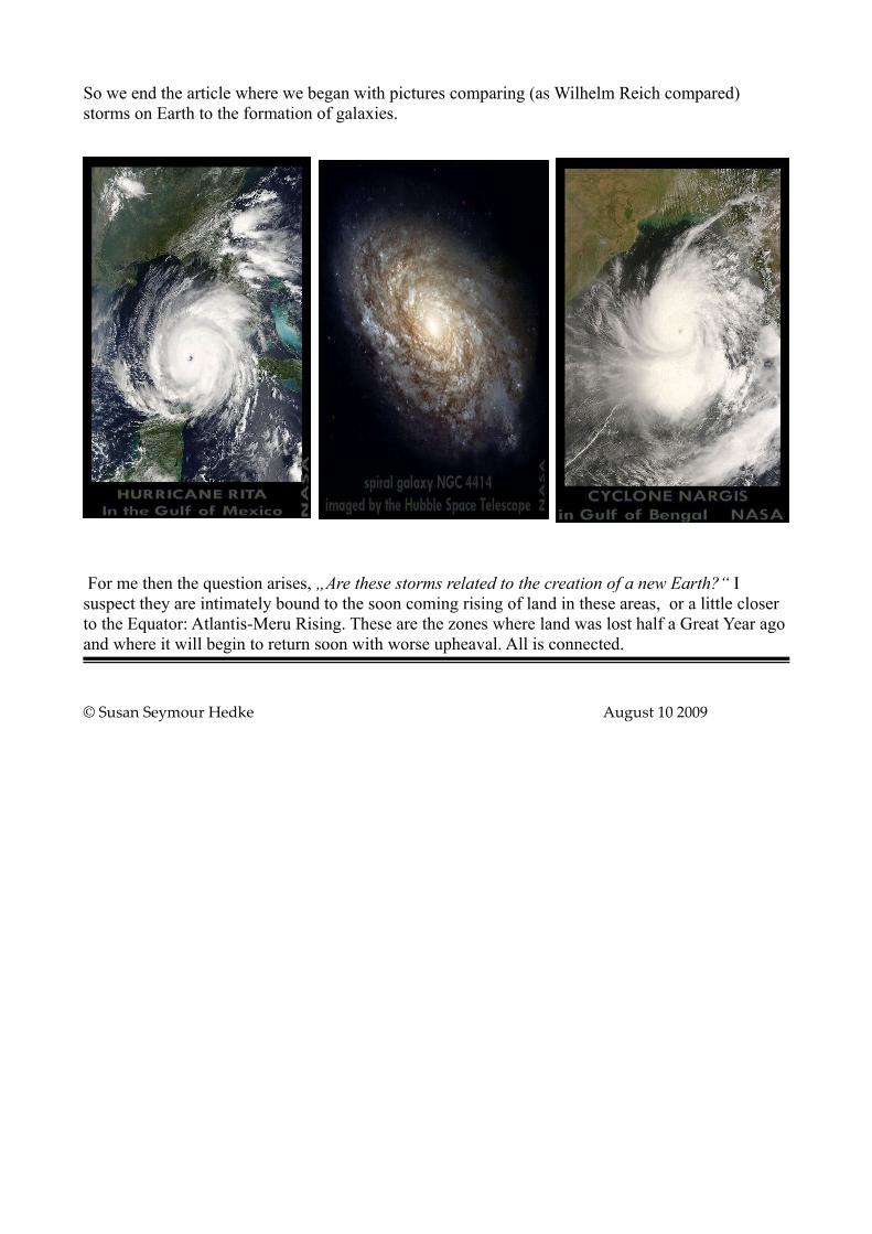
So we end the article where we began with pictures comparing (as Wilhelm Reich compared) storms on Earth to the formation of galaxies.
For me then the question arises, „Are these storms related to the creation of a new Earth?“ I suspect they are intimately bound to the soon coming rising of land in these areas, or a little closer to the Equator: Atlantis-Meru Rising. These are the zones where land was lost half a Great Year ago and where it will begin to return soon with worse upheaval. All is connected.
© Susan Seymour Hedke August 10 2009
i http://de.wikipedia.org/wiki/Atlantische_Hurrikansaisons_1492%E2%80%931600
ii http://encarta.msn.com/media_701500587_761578503_- 1_1/major_hurricanes_typhoons_cyclones_and_other_storms_since_1900.html
iii http://en.wikipedia.org/wiki/1919_Florida_Keys_hurricane
iv http://en.wikipedia.org/wiki/Hurricane_Audrey
v http://www.thisdaythatyear.com/dec/events15.htm
vi http://www.chicagotribune.com/news/politics/chi-chicagodays-1967blizzard-story,0,1032940.story
vii http://en.wikipedia.org/wiki/Hurricane_Celia
viiihttp://en.wikipedia.org/wiki/Hurricane_Andrew
ix http://en.wikipedia.org/wiki/1996_North_Indian_Ocean_cyclone_season
x http://en.wikipedia.org/wiki/Tropical_Storm_Allison
xi http://en.wikipedia.org/wiki/Hurricane_Rita