fylde borough council open space study update may 2016 · may 2016 open space study: knight,...
TRANSCRIPT

Integrity, Innovation, Inspiration Knight, Kavanagh & Page Ltd Company No: 9145032 (England)
MANAGEMENT CONSULTANTS Registered Office: 1 -2 Frecheville Court, off Knowsley Street, Bury BL9 0UF
T: 0161 764 7040 E: [email protected] www.kkp.co.uk
FYLDE BOROUGH COUNCIL OPEN SPACE STUDY UPDATE MAY 2016


FYLDE BOROUGH COUNCIL OPEN SPACE STUDY
CONTENTS PART 1: INTRODUCTION ................................................................................................ 1 PART 2: METHODOLOGY ............................................................................................. 12 PART 3: GENERAL OPEN SPACE SUMMARY ............................................................. 18 PART 4: PARKS AND GARDENS .................................................................................. 21 PART 5: NATURAL AND SEMI-NATURAL GREENSPACES ......................................... 27 PART 6: AMENITY GREENSPACE ................................................................................ 33 PART 7: PROVISION FOR CHILDREN AND YOUNG PEOPLE .................................... 47 PART 8: ALLOTMENTS, COMMUNITY GARDENS AND CITY FARMS ........................ 56 PART 9: CEMETERIES, CHURCHYARDS AND BURIAL GROUNDS ........................... 61 APPENDIX 1: COMMUNITY SURVEY SUMMARY ........................................................ 66

FYLDE BOROUGH COUNCIL OPEN SPACE STUDY
May 2016 Open Space Study: Knight, Kavanagh and Page 1
PART 1: INTRODUCTION This is the updated Open Space Assessment Report prepared by Knight Kavanagh & Page (KKP) for Fylde Borough Council. It focuses on reporting the findings of the research, consultation, site assessments, data analysis and GIS mapping that underpin the study. The Assessment Report provides detail with regard to what provision exists in the area, its condition, distribution and overall quality. It considers the demand for provision based upon population distribution, planned growth and consultation findings. The Strategy (to follow the assessment reports for open spaces) will give direction on the future provision of accessible, high quality, sustainable provision for open spaces in Fylde. Although there is no national guidance dictating how often an Open Space Assessment Report should be conducted, an appropriate time scale for review is five years. This Open Space Assessment report is an update of the 2008 Open Space, Sport and Recreation study. Therefore, the Open Space Assessment Report following this should not be an update and should include the reassessment of open space sites in Fylde. In order for planning policies to be ‘sound’ local authorities are required to carry out a robust assessment of need for open space, sport and recreation facilities. We advocate that the methodology to undertake such assessments should still be informed by best practice including the Planning Policy Guidance 17 (PPG17) Companion Guidance; Assessing Needs and Opportunities’ published in September 2002. Although PPG17 has now been replaced by the National Planning Policy Framework, (the Framework), assessment of open space facilities is still normally carried out in accordance with the Companion Guidance ‘as it remains the only national advice on the conduct of an open space assessment. It also still reflects the Government policy objectives for open space, sport and recreation, as set out in PPG17. The long-term outcomes aim to deliver: Networks of accessible, high quality open spaces and sport and recreation facilities,
in both urban and rural areas, which meet the needs of residents and visitors that are fit for purpose and economically and environmentally sustainable.
An appropriate balance between new, and the enhancement of existing, provision. Clarity and reasonable certainty for developers and landowners in relation to the
requirements and expectations of local planning authorities in respect of open space and sport and recreation provision.
In accordance with best practice recommendations a size threshold of 0.2 hectares has been applied to the inclusion of some typologies within the study. This means that, in general, sites that fall below this threshold are not audited.

FYLDE BOROUGH COUNCIL OPEN SPACE STUDY
May 2016 Open Space Study: Knight, Kavanagh and Page 2
The table below details the open space typologies included within the study: Table 1.1: Open space typology definitions Typology Primary purpose
Gre
en
sp
ace
s
Parks and gardens Accessible, high quality opportunities for informal recreation and community events.
Natural and semi-natural greenspaces
Wildlife conservation, biodiversity and environmental education and awareness. Includes urban woodland and beaches, where appropriate.
Amenity greenspace Opportunities for informal activities close to home or work or enhancement of the appearance of residential or other areas.
Provision for children and young people
Areas designed primarily for play and social interaction involving children and young people, such as equipped play areas, MUGAs, skateboard areas and teenage shelters.
Allotments Opportunities for those people who wish to do so to grow their own produce as part of the long term promotion of sustainability, health and social inclusion.
Green corridors Walking, cycling or horse riding, whether for leisure purposes or travel, and opportunities for wildlife migration.
Cemeteries, disused churchyards and other burial grounds
Quiet contemplation and burial of the dead, often linked to the promotion of wildlife conservation and biodiversity.
Civ
ic
sp
ace
s Civic and market squares and
other hard surfaced areas designed for pedestrians including the promenade
Providing a setting for civic buidings, public demonstrations and community events.
1.1 Report structure Open spaces This report considers the supply and demand issues for open space provision across Fylde. Each part contains relevant typology specific data. Further description of the methodology used can be found in Part 2. The report as a whole covers the predominant issues for all open spaces originally defined in ‘Assessing Needs and Opportunities: A Companion Guide to PPG17’; it is structured as follows: Part 4: Parks and gardens Part 5: Natural/ semi-natural greenspace Part 6: Amenity greenspace Part 7: Provision for children/young people Part 8: Allotments Part 9: Cemeteries/churchyards Part 10: Civic space

FYLDE BOROUGH COUNCIL OPEN SPACE STUDY
May 2016 Open Space Study: Knight, Kavanagh and Page 3
Associated strategies The study sits alongside the Playing Pitch Strategy (PPS) which is also being undertaken by KKP (provided in a separate report). The open space typology of formal outdoor sports is covered within the associated PPS. The PPS is undertaken in accordance with the methodology provided in Sport England’s Guidance ‘Playing Pitch Strategy Guidance’ for assessing demand and supply for outdoor sports facilities (October, 2013). 1.2 National context National Planning Policy Framework The Framework sets out the planning policies for England. It details how these are expected to be applied to the planning system and provides a framework to produce distinct local and neighbourhood plans, reflecting the needs and priorities of local communities. It states that the purpose of the planning system is to contribute to the achievement of sustainable development. It establishes that the planning system needs to focus on three themes of sustainable development: economic, social and environmental. A presumption in favour of sustainable development is a key aspect for any plan-making and decision-taking processes. In relation to plan-making the Framework sets out that Local Plans should meet objectively assessed needs. Under paragraph 73 of the Framework, it is set out that planning policies should be based on robust and up-to-date assessments of the needs for open space, sports and recreation facilities and opportunities for new provision. Specific needs and quantitative and qualitative deficiencies and surpluses in local areas should also be identified. This information should be used to inform what provision is required in an area. As a prerequisite paragraph 74 of the Framework states existing open space, sports and recreation sites, including playing fields, should not be built on unless:
An assessment has been undertaken, which has clearly shown the site to be surplus to requirements.
The loss resulting from the proposed development would be replaced by equivalent or better provision in terms of quantity and quality in a suitable location.
The development is for alternative sports and recreational provision, the needs for which clearly outweigh the loss.
1.3 Local context This study and its findings are important in their contribution to the council’s Local Plan. They form an integral part of identifying and regulating the open space infrastructure. Through recognising open space provision in plan form, it can be assessed in terms of quantity, quality and accessibility, whilst strengthening its presence in planning policy for the future and maximising opportunities for investment.

FYLDE BOROUGH COUNCIL OPEN SPACE STUDY
May 2016 Open Space Study: Knight, Kavanagh and Page 4
The Fylde Borough Local Plan (As Altered: October 2005) The Fylde Borough Local Plan (As Altered: October 2005) is an amalgamation of two documents: The Fylde Borough Local Plan 1996-2006 and the Fylde Borough Local Plan Alterations Review 2004-2016. The strategy of the local plan is based on the broad goal: ‘To provide for the necessary growth and development of the Borough in ways which are sustainable and which seek to preserve and enhance the quality of environment for those living and/or working in the Borough and for visitors.’ The achievement of this goal will be reached through the implementation of smaller aims and further to this, objectives such as: To limit development in the open countryside and Green Belt to that appropriate to a
rural area and necessary for the well being of the rural community. To protect visually important open areas, within towns and rural settlements, from
development. To protect visually important trees and woodlands and secure additional tree planting
in both urban and rural situations. To protect areas important for nature conservation from unnecessary development. To protect areas of undeveloped coastline from unnecessary development. To maintain and extend the range of sport, leisure and recreational facilities within the
borough for both residents and visitors. To maintain and extend the availability of urban green space, including public open
space, recreational play-space and other open areas used for recreation and to maintain and extend the availability of allotments where needed.
To identify and safeguard sites for formal recreation and sports facilities. To facilitate access links from urban areas to adjacent countryside. Current policies for open space, sport and recreation are set out throughout the local plan. The key policies relating to open space, sport and recreation are broken down by chapter and highlighted below. Table 1.1: Chapter 5: Transportation
Policy TR1 The creation of new recreational footpaths and the maintenance, way marking and publicising of existing public rights of way.
Policy TR2 Increased provision for bridleways will be made particularly in areas of high demand and where existing bridleways are fragmented.
Table 1.2: Chapter 6: Tourism and Recreation
Policy TREC 11 The Lancaster Canal Corridor will be protected in view of its countryside location, local landscape character, recreational and amenity value and identifies nature conservation interest.
Policy TREC 13 All existing areas of public open space will be safeguarded from development unless as a result of development, equivalent or improved provision would be achieved in the locality.
Policy TREC 14 Playing fields and recreational facilities will be safeguarded from development. Planning permission for development on playing fields and other recreational facilities unless they meet specific requirements. For example, the proposed development is ancillary to the use of the site as a playing field.

FYLDE BOROUGH COUNCIL OPEN SPACE STUDY
May 2016 Open Space Study: Knight, Kavanagh and Page 5
Policy TREC 17 Within housing developments, the provision of an amenity open space with facilities for children’s play, where appropriate, will be required to meet certain standards (as set out in the policy).
Arrangements will also be made by developers to provide effective future maintenance of the site.
Policy TREC 18 Development on allotment gardens is not permitted unless it can be demonstrated that little demand exists and allotments are substantially under-used or that alternative equivalent or improved facilities will be provided in the same locality.
Table 1.3: Chapter 7: Environmental protection and conservation
Policy EP2 Development will not be permitted upon open spaces, defined on the proposal map, which are considered to be essential to the setting, character or visual amenities of towns and villages.
Policy EP3 New development within, or affecting the setting of a designated conservation area will only e permitted where the character or appearance of the area, and its setting, are appropriately conserved or enhanced.
Policy EP6
Development within a designated historic park or garden will not be permitted where this would prejudice its quality, character or appearance. Development outside an historic park or garden which would harm its setting will not be permitted.
Policy EP10 The distinct character and important habitats of Fylde Borough will be protected, both in terms of its coastal and inland elements.
The Fylde Borough Local Plan (As Altered: October 2005) is currently in the process of being superseded by The Fylde Local Plan to 2032, which will be adopted in March 2017. Fylde Local Plan to 2032 (Revised Preferred Option) In the Fylde Local Plan to 2032, Fylde is described as having a combination of classic seaside resort towns and historic market towns alongside large areas of countryside. The Fylde Local Plan to 2032 focuses on sustainable development through three dimensions: social, economic and environmental. The environmental aspect focuses on ‘contributing to protecting and enhancing our natural, built and historic environment; and, as part of this, helping to improve biodiversity, use natural resources prudently, minimise waste and pollution, and mitigate and adapt to climate change including moving to a low carbon economy.’ There are cross cutting themes throughout the Fylde Local Plan to 2032 of: Promoting health and wellbeing, equality, viability, achieving good design and sustainability. Chapter 11 expresses the importance of greenspaces for people’s health and wellbeing, and therefore the need retaining and expand (where opportunity arises) on existing greenspaces. The key policies relating to open space, sport and recreation that are set out within the Fylde Local Plan to 2032 can be seen overleaf:

FYLDE BOROUGH COUNCIL OPEN SPACE STUDY
May 2016 Open Space Study: Knight, Kavanagh and Page 6
Chapter 9 – Policy EC6 - Leisure, Culture and Tourism Development The council will plan for leisure, culture and tourism by:
a) Promoting St Annes as a classic seaside resort, based on its tourism heritage, the seafront, Promenade and Ashton Gardens, its Victorian architecture and Pier.
b) Promoting the principles of sustainable tourism through realising the potential of the Borough’s heritage assets, in particular the Promenade Gardens and Ashton Gardens, St Annes Pier, Lytham Hall and its historic parkland, Lytham Windmill and Lowther Pavilion and Gardens.
c) Supporting the high quality physical regeneration of The Island Sea Front Area at St Annes and the protection of seaside resort facilities, to support wider tourism, culture and the local economy.
d) Physical regeneration and enhancement of the manmade coastal defences at The Island Sea Front Area, Fairhaven Lake and Church Scar in order to encourage coastal tourism and recreation and help maintain flood defences.
e) Encouraging daytime and evening business, leisure, cultural and heritage based tourism facilities, such as hotels, restaurants, cinemas, theatres, museums, swimming pools and leisure centres within town centres in Key Service Centres and in Local Service Centres.
f) Protecting tourism, cultural, heritage and leisure assets, such as golf courses and the seaside resort facilities, with a view to helping them to adapt to new challenges by the use of development briefs.
g) Promoting public art and public realm works and seeking developer contribution funding where appropriate and CIL compliant.
h) Promoting beach leisure activities, coastal tourism and recreational events. i) Promoting the Ribble Coast and Wetlands Regional Park initiative and
implementing the infrastructure projects identified in the Coastal Strategy, including the delivery of tourism and recreation.
j) Encouraging the provision of training in leisure, culture or tourism development. k) Project specific Habitats Regulations Assessments (HRAs) will be required for
any tourism and coastal defence developments near to the Ribble and Alt Estuaries SPA/Ramsar. The HRAs will need to demonstrate that there will be no significant effect upon European Sites before the tourism and / or coastal defence developments can be granted consent.
The Island Sea Front Area at St Annes
Leisure, culture and tourism development within The Island Sea Front Area, as defined
on the Policies Map, will be encouraged provided that proposals:
i) are appropriate for a seafront location;
ii) conserve and enhance heritage assets and their setting;
iii) respect the character of the area; and
iv) do not prejudice the visual and other amenities of the seafront and nearby
residential properties.
Non leisure, culture and tourism uses will not be permitted in this Sea Front Area.

FYLDE BOROUGH COUNCIL OPEN SPACE STUDY
May 2016 Open Space Study: Knight, Kavanagh and Page 7
Ribby Hall Village Development of additional leisure, culture and tourism uses at Ribby Hall Village will be permitted, provided that the amenities and character of the site are preserved and enhanced. The boundary of Ribby Hall Village is identified on Policies Map. Rural Tourism The promotion and enhancement of rural tourism will be encouraged through rural diversification to create small-scale, sensitively designed visitor attractions which:
1. Take advantage of the Borough’s natural environment and heritage assets, including the Lancaster Canal corridor and towpath;
2. Encourage the reuse, rehabilitation and conversion of existing permanent and substantial buildings in rural areas to support the visitor economy;
3. Promote walking, cycling and horse riding, including long distance routes and linkages to national networks and trails, improvements to the coastal path and access to the coast;
4. Contribute to the Ribble Coast and Wetlands Regional Park and to Fylde’s open coastline and their enjoyment by visitors; and
5. Provide opportunities to access and learn about the natural and historic environment.
Table 1.4: Chapter 11: Health and Wellbeing
Policy HW3 Protecting existing provision of indoor and outdoor sports facilities as well as supporting new facilities where accessible through transport networks.
Chapter 12 - Policy T3 Enhancing Sustainable Transport Choice
a) Improve community health and wellbeing by providing alternative means of transport such as walking and cycling. This will be achieved through protecting and enhancing the existing public rights of way network; the provision of additional footpaths, cycleways and bridleways, where appropriate; and safeguarding land for the provision of a continuous footpath, cycleway and bridleway network along Fylde’s coastline;
Table 1.5: Chapter 14: Conserving and Enhancing the Natural, Historic and Built Environment
Policy ENV2 The Council is committed to ensuring the protection and enhancement of Fylde’s biodiversity and geological assets and interests.
Policy ENV4 The existing areas of open space which will be identified on the Policies Map comprise the Green Infrastructure network within Fylde. The Green Infrastructure network will be protected from inappropriate development
Policy ENV5 Within new housing developments comprising ten or more homes the provision of amenity open space with facilities for children’s play (i.e. playgrounds and Multi-Use Games areas including LAPs and LEAPs), will be required to meet standards as set out in the policy.
Financial contributions will be sought through the Community Infrastructure Levy (the CIL) to assist schemes for other safe green open space (the Green Infrastructure network) where there is an identified need, including the provision of allotments, trees and woodland.

FYLDE BOROUGH COUNCIL OPEN SPACE STUDY
May 2016 Open Space Study: Knight, Kavanagh and Page 8
Where there is an identified over-provision of open space in close proximity to the application site, the monies generated from the development of the site and development in close proximity to it will be used to enhance the quality of, and accessibility to, the existing open space network. Opportunities to link open spaces to create a multi-functional Green Infrastructure network will be maximised. Financial contributions will be sought through the Community Infrastructure Levy (the CIL) to assist such schemes.
Policy ENV6 Protection of historical sites including parks and gardens, scheduled monuments and conservation areas.
Key issues relating to open space highlighted in the Fylde Local Plan to 2032 are: A need to improve the links between Green Infrastructure through the enhancement
of the Green Infrastructure network. “Green Infrastructure is a network of multi-functional green space, urban and rural, which is capable of delivering a wide range of environmental and quality of life benefits for local communities. Green Infrastructure includes parks, open spaces, playing fields, woodlands, street trees, allotments and private gardens”. (Planning Practice Guidance 2014). A need to increase opportunity for activities for young adults and children. A need to tackle the deficit in parks and garden provision in the Borough. Green Infrastructure in Fylde includes its 18 kilometre coastline. Fylde has a separate strategy for its coastline which presents a 16 year vision for its regeneration. Fylde Local Plan to 2032 – Publication Version The Fylde Local to 2032 (Publication Version) highlights five local areas together with the level of housing growth over the plan period (an occupancy rate of 2.00 is used as set out in the council’s Housing Requirement Paper 2015):
Local areas Number of homes Associated population
Lytham and St Annes 2,020 4,040
Fylde-Blackpool Periphery 2,728 5,456
Warton 778 1,556
Kirkham and Wesham 1,142 2,284
Rural Areas 720 1,440
Totals 7,388 14,776
All of these aside from Rural Areas are strategic locations. Within strategic locations development must be met with the necessary infrastructure. This includes Green Infrastructure, culture and leisure opportunities, as stated in the Fylde Infrastructure Delivery Plan (IDP). This is ensured through masterplanning and design codes described in policies within Chapter 7 in the Fylde Local Plan to 2032 (Publication Version).

FYLDE BOROUGH COUNCIL OPEN SPACE STUDY
May 2016 Open Space Study: Knight, Kavanagh and Page 9
Figure 2.1: Study analysis areas with strategic locations
Fylde Coastal Strategy 2015-2032 The Fylde Costal Strategy 2015-2032 is guided by the National Planning Policy Framework, the Green Infrastructure study 2011 and the Fylde Local Plan (to 2032). The overall vision for the costal strategy is “To create a unique, high quality destination for residents and visitors, which is based on the conservation and enhancement of the natural landscape and heritage assets of the coastal area of the Borough of Fylde”. The strategy is made up of ten themes and a detailed action plan, which applies the key actions stated in the themes section to zones along the Fylde coastline. These zones are identified as ‘character zones’. ‘Character zones are determined based on landscape character and usage. A list of the zones can be seen below: Zone 1 Starr Hills Sand Dunes and Beaches Zone 2 St Anne’s on the Sea Zone 3 Fairhaven Sand Dunes Zone 4 Fairhaven Lake, Gardens and Granny’s Bay Zone 5 Lytham Heritage Coast Zone 6 Warton, Freckleton, Clifton and Lancaster Canal

FYLDE BOROUGH COUNCIL OPEN SPACE STUDY
May 2016 Open Space Study: Knight, Kavanagh and Page 10
Below are key parts within the themes of section one, as well as the key actions suggested relating to Green Infrastructure, the open spaces assessment report and the subsequent open space strategy: Theme 4: Nature Conservation and Habitat Improvement The coastline in Fylde stretches over twelve miles and as well as having to fulfil a recreational need, contains many different landscape types and unique habitats. The foreshore in Fylde has areas designated as a Site of Specific Scientific Interest (SSSI). Furthermore, a section of the sand dunes (Starr Hills) is a Local Nature Reserve (LNR), and makes up part of the Lytham St Anne’s Dunes. Ribble Estuary is also one of the most important wildlife habitats in Europe. In order to enhance and protect these sites key actions set out in the Fylde Coastal Strategy are to: Integrate LNR, SSSI and biological heritage sites to create a regionally significant
nature reserve. Develop and implement beach and sand dunes Management Action Plans. Theme 7: Heritage Assets Fylde is home to three historic parks: Ashton Gardens, Promenade Gardens and Lytham Hall Park, all of which are grade II listed as such on the National Register. Due to being a heritage asset to Fylde, Ashton Gardens in St. Anne’s has recently undergone major restoration through a project funded primarily through the Heritage Lottery Fund. The opportunity to similarly refurbish the other historic parks and gardens in the Borough will be an important part of the Fylde Council Coastal Strategy 2015-2032. Other key actions include: Protect, enhance and manage Historic Assets. Work closely with stakeholders and the community to develop and implement
proposals for the enhancement of the Heritage Assets. Prepare and adopt Conservation Area Appraisals and Management Plans Theme 9: Access and Transportation As part of the Green Infrastructure Network a key action is to create more cycle ways, footpaths and bridleways with improved signage, encouraging people to visit Green Infrastructure within the borough. It is important to create an alignment between the Fylde Local Plan and the Fylde Coast Highways and Transport Masterplan. This will create an effective, well managed network of pedestrian and cycle links to and around the coast, which meet the transport requirements of the borough. This will also need to be in line with the Natural England Coastal pathways. This will also help to tackle the issue of rural settlements in the borough having poor access to the coastline.

FYLDE BOROUGH COUNCIL OPEN SPACE STUDY
May 2016 Open Space Study: Knight, Kavanagh and Page 11
Theme 10: Marketing, Promotion and Publicity The Borough of Fylde has five Green Flag sites: Ashton Gardens, Promenade Gardens, Fairhaven Lake and Gardens, Lytham Memorial Gardens, and Lowther Gardens. These sites are of great importance to the area. In reflection of this key actions are: To continue to support Green Flag awards Winning the In Bloom competition administered by the Royal Horticultural Society is seen as a great achievement for any area. Following the borough being extremely successful in this competition with ‘Lytham being described by Britain in Bloom judges as the cleanest, greenest most beautiful location in Britain and being awarded the accolade of Champion of Champions as the best place to visit in the entire nation’ the key actions are: To continue to support the Royal Horticultural Societies In Bloom initiative The Fylde Local Plan to 2032 also discusses the desire to apply for the Britain Tidy’s Seaside Award and to continue supporting the Royal Horticultural Societies in Bloom initiative. This means one of the key actions for theme ten is: To apply for a seaside award for St Anne’s amenity beach This will also lead to possibilities of increased tourism in the Borough.

FYLDE BOROUGH COUNCIL OPEN SPACE STUDY
May 2016 Open Space Study: Knight, Kavanagh and Page 12
PART 2: METHODOLOGY 2.1 Study area The area of Fylde consists of the major conurbations of Freckleton and Warton, Kirkham and Wesham, Lytham St Annes and Rural Areas. Lytham St Anne’s is a traditional seaside resort with a Victorian pier. The main towns within the Borough are the towns of Lytham, St Anne’s and Kirkham. The Borough also contains the smaller urban areas of Freckleton, Warton and Singleton and many smaller parishes. For mapping purposes and audit analysis, Fylde is divided into four analysis areas (reflecting the geographic and demographic nature of the area). These allow more localised assessment of provision in addition to examination of open space surplus and deficiencies at a more local level. Use of analysis areas also allows local circumstances and issues to be taken into account. The area is therefore, broken down as shown in Figure 2.1. Figure 2.1 also shows the population density of each analysis area. The darker grey areas highlight a higher population density and the light grey areas show where the population density is lower. This helps to determine gaps in catchment mapping for each typology throughout the report. Figure 2.1: Fylde analysis areas

FYLDE BOROUGH COUNCIL OPEN SPACE STUDY
May 2016 Open Space Study: Knight, Kavanagh and Page 13
Table 2.1: Fylde analysis area population
Analysis area Current population* Population growth Future population†
Freckleton and Warton 9,593 1,556 11,149
Kirkham and Wesham 13,140 2,284 15,424
Lytham St Annes 8,728 4,388 13,116
Rural Areas 42,752 6,548 49,300
Totals 74,213 14,776 88,989
2.2 Auditing local provision (supply) A desktop update of the audit has been completed and took into account any changes identified through consultation with council officers and parish/town councils. In total, 293 open spaces (including provision for children and young people) are identified, mapped and assessed to evaluate site value and quality. Each site is classified based on its primary open space purpose, so that each type of space is counted only once. The audit, and the report, identify the following typologies: 1. Parks and gardens 2. Natural and semi-natural greenspace 3. Amenity greenspace 4. Provision for children and young people 5. Allotments 6. Cemeteries/churchyards The provision of formal outdoor sports is contained within the associated Playing Pitch Strategy (PPS). In accordance with best practice recommendations a size threshold of 0.2 hectares has been applied to the inclusion of some typologies within the study. This means that, in general, sites that fall below this threshold are not audited. However, any sites below the threshold (i.e. those that are identified through consultation as being of significance) are included. The table below details the threshold for each typology:
Typology Size threshold
Parks and gardens no threshold
Natural and semi-natural greenspace 0.2 ha
Amenity greenspace 0.2 ha
Provision for children and young people no threshold
Allotments no threshold
Cemeteries/churchyards no threshold
* Source: ONS Mid-2014 Population Estimates for Lower Layer Super Output Areas in England and Wales by Single Year of Age and Sex † We have used the Fylde Local Areas to calculate likely future population growth in each Study Analysis Area. Fylde-Blackpool Periphery Strategic Location for Development which is located within the Lytham St Annes Analysis Area is the Coastal Dunes (the former Pontins site), which amounts to 348 homes.

FYLDE BOROUGH COUNCIL OPEN SPACE STUDY
May 2016 Open Space Study: Knight, Kavanagh and Page 14
Database development All information relating to open spaces is collated in the project open space database (supplied as an Excel electronic file). All sites assessed, identified and assessed as part of the audit are recorded on it. The database details for each site are as follows:
Data held on open spaces database (summary)
KKP reference number (used for mapping) Site name Ownership Management Typology Size (hectares) Site visit data
Sites are primarily identified by KKP in the audit using official site names, where possible, and/or secondly using road names and locations. 2.3 Quality and value Quality and value are fundamentally different and can be unrelated. For example, a high quality space may be inaccessible and, thus, be of little value; while, if a rundown (poor quality) space may be the only one in an area and thus be immensely valuable. As a result, quality and value are also treated separately in terms of scoring. Each type of open space receives separate quality and value scores. This also allows for application of a high and low quality/value matrix to further help determine prioritisation of investment and to identify sites that may be surplus within and to a particular open space typology. Analysis of quality Data collated in relation to quality is initially based upon those derived from the Green Flag Award scheme (a national standard for parks and green spaces in England and Wales, operated by Keep Britain Tidy). This is utilised to calculate a quality score for each site visited. Scores in the database are presented as percentage figures. The quality criteria used for the open space assessments carried out are summarised in the following table.
Quality criteria for open space site visit (score)
Physical access, e.g., public transport links, directional signposts, Personal security, e.g., site is overlooked, natural surveillance Access-social, e.g., appropriate minimum entrance widths Parking, e.g., availability, specific, disabled parking Information signage, e.g., presence of up to date site information, notice boards Equipment and facilities, e.g., assessment of both adequacy and maintenance of provision
such as seats, benches, bins, toilets Location value, e.g., proximity of housing, other greenspace Site problems, e.g., presence of vandalism, graffiti Healthy, safe and secure, e.g., fencing, gates, staff on site Maintenance and cleanliness, e.g., condition of general landscape and features Groups that the site meets the needs of, e.g., elderly, young people Site potential

FYLDE BOROUGH COUNCIL OPEN SPACE STUDY
May 2016 Open Space Study: Knight, Kavanagh and Page 15
For the provision for children and young people, criteria are also built around Green Flag. It is a non technical visual assessment of the whole site, including general equipment and surface quality/appearance plus an assessment of, for example, bench and bin provision. This differs, for example, from an independent RosPA review, which is a more technical assessment of equipment in terms of play and risk assessment grade. Analysis of value
Site visit data plus desk based research is calculated to provide value scores for each site identified. Value is defined in the Companion Guide relation to the following three issues: Context of the site i.e. its accessibility, scarcity value and historic value. Level and type of use. The wider benefits it generates for people, biodiversity and the wider environment. The value criteria set for audit assessment is derived as:
Value criteria for open space site visits (score)
Level of use (observations only), e.g., evidence of different user types (e.g. dog walkers, joggers, children) throughout day, located near school and/or community facility
Context of site in relation to other open spaces Structural and landscape benefits, e.g., well located, high quality defining the identity/ area Ecological benefits, e.g., supports/promotes biodiversity and wildlife habitats Educational benefits, e.g., provides learning opportunities on nature/historic landscapes Social inclusion and health benefits, e.g., promotes civic pride, community ownership and a
sense of belonging; helping to promote well-being Cultural and heritage benefits, e.g., historic elements/links (e.g. listed building, statues) and
high profile symbols of local area Amenity benefits and a sense of place, e.g., attractive places that are safe and well
maintained; helping to create specific neighbourhoods and landmarks Economic benefits, e.g., enhances property values, promotes economic activity and attracts
people from near and far
Value - non site visit criteria (score)
Designated site such as LNR or SSSI Educational programme in place Historic site Listed building or historical monument on site Registered 'friends of’ group to the site
Children’s and young people play provision is scored for value as part of the audit assessment. Value, in particular is recognised in terms of size of sites and the range of equipment it hosts. For instance, a small site with only one or two items is likely to be of a lower value than a site with a variety of equipment catering for wider age ranges. 2.4 Quality and value thresholds To determine whether sites are high or low quality (as recommended by guidance); the results of the site assessments are colour-coded against a baseline threshold (high being green and low being red). The primary aim of applying a threshold is to identify sites where investment and/or improvements are required. It can also be used to set an aspirational quality standard to be achieved at some point in the future and to inform decisions around the need to further protect sites from future development (particularly when applied with its respective value score in a matrix format).

FYLDE BOROUGH COUNCIL OPEN SPACE STUDY
May 2016 Open Space Study: Knight, Kavanagh and Page 16
The baseline threshold for assessing quality can often be set around 66%; based on the pass rate for Green Flag criteria (site visit criteria also being based on Green Flag). This is the only national benchmark available for quality of parks and open spaces. However, the site visit criteria used for Green Flag is not appropriate for every open space typology as it is designed to represent a sufficiently high standard of site. Quality thresholds are, thus, worked out so as to better reflect average scores for each typology. Consequently, the baseline threshold for certain typologies is amended to better reflect this. For value there is no national guidance on the setting of thresholds. The 15% threshold applied is derived from our experience and knowledge in assessing the perceived value of sites. Whilst 15% may initially seem low it is relative score - designed to reflect those sites that meet more than one aspect of the criteria used for assessing value (as detailed earlier). A table setting out the quality and value scores for each typology is provided overleaf. Table 2.2: Quality and value thresholds by typology
Typology Quality threshold Value threshold
Allotments 35% 15%
Amenity greenspace 50% 15%
Cemeteries/churchyards 44% 15%
Natural and semi-natural greenspace 23% 15%
Parks and gardens 60% 15%
Provision for children and young people 50% 15%
2.5 Identifying local need (demand) Consultation to update local need for open space provision has been carried out via surveys to town/parish councils and an online resident’s survey. Consultation has also been conducted with key local authority officers. The findings of the consultation and survey results are used, reviewed and interpreted to further support the results of the quality and value assessment. 2.6 Accessibility standards Accessibility standards for different types of provision are a tool to identify communities currently not served by existing facilities. It is recognised that factors that underpin catchment areas vary from person to person, day to day and hour to hour. For the purposes of this process this problem is overcome by accepting the concept of ‘effective catchments’, defined as the distance that is willing to be travelled by the majority of users. Guidance on appropriate walking distance and times is published by Fields in Trust (FIT) in its document Beyond the Six Acre Standard (2015). These guidelines have been converted in to an equivalent time travel catchment in the table below and applied to each typology within the relevant section of the report.

FYLDE BOROUGH COUNCIL OPEN SPACE STUDY
May 2016 Open Space Study: Knight, Kavanagh and Page 17
Table 2.3: FIT walking guidelines
Open space typology Walking guideline Approximate time equivalent
Parks and gardens 710m 9 minute
Amenity greenspace 480m 6 minute
Natural and semi-natural greenspace 720m 9 minute
Provision for children and young people 100m (LAP)
400m (LEAP)
1,000m (NEAP)
1 minute
5 minutes
13 minutes
No standard is set for the typologies of cemeteries or civic spaces. It is difficult to assess such typologies against catchment areas due to their nature and usage. For cemeteries, provision should be determined by demand for burial space.

FYLDE BOROUGH COUNCIL OPEN SPACE STUDY
May 2016 Open Space Study: Knight, Kavanagh and Page 18
PART 3: GENERAL OPEN SPACE SUMMARY This section describes generic trends and findings from the quality and value ratings for each typology in the Four Towns. It describes the generic issues that cut across more than one typology. The typology and site specific issues are covered in the relevant sections later in this report. 3.1 Quality The methodology for assessing quality is set out in Part 2. The table below summarises the results of all the quality assessment for open spaces across Fylde. Table 3.1: Quality scores for all open space typologies
Typology Threshold Maximum score
Scores No. of sites
Lowest score
Average score
Highest score
Low High
Allotments 35% 124 38% 61% 36% 3 5
Amenity greenspace 50% 121 50% 83% 83% 89 80
Cemeteries/ churchyards
44% 161 44% 62% 33% 2 2
Provision for children and young people
50% 97 50% 82% 56% 23 26
Parks and gardens 60% 159 60% 84% 49% 6 7
Natural and semi-natural greenspace
23% 117 23% 63% 63% 18 19
TOTAL 141 139
For natural and semi-natural greenspace and amenity greenspace typologies, low scores can be a reflection of the number of sites without any specific ancillary features or facilities. Sites for the typology of natural and semi-natural greenspace can also tend to score low for personal security given they are often in isolated locations and not overlooked by other land uses. Often sites deliberately have very little ongoing management or maintenance in order to provide, for example, wildlife habitats. However, keeping on top of issues such as litter and dog fouling is important to maintain higher quality scores. Just under half of parks and gardens (46%) in Fylde rate below the threshold for quality. This is not necessarily a reflection on any specific issues at the sites. Instead it is more likely a result of the threshold for parks being set particularly high. This is in order to distinguish the very best and often strategic park sites from more localised forms of provision. It is important that large and prominent sites such as Lowther Gardens, West Beach are assessed against criteria intended to do this, so that provision can be to the highest standard. This also complies with the Green Flag Award scheme pass criteria. Subsequently it may not be appropriate for all forms of provision. The typology of allotments scores fairly high for quality, with 62.5% of sites scoring above the quality threshold. This can be attributed to allotment sites being looked after further to any general maintenance that takes place, by individuals who have plots on the site.

FYLDE BOROUGH COUNCIL OPEN SPACE STUDY
May 2016 Open Space Study: Knight, Kavanagh and Page 19
Management of sites The grounds maintenance of Borough Council parks and open spaces is undertaken by numerous site based teams, spread across the Borough. The gardening staff are employed ‘in house’ by the Parks and Greenspace Team in the Development Services Directorate, and cover the areas of St. Annes, Ansdell and Lytham. The other areas of the Borough are under Parish Council control, which employ their gardeners directly. However, the Parks and Greenspace Team undertake the grounds maintenance in Kirkham on a contract basis, as well as delivering numerous additional external contracts, within and outside the Borough. Parks staff also includes a mobile team that carries out non programmed landscape or urgent remedial work, and an arboriculture team that is responsible for the maintenance of the council’s tree stock. Children's play areas are inspected and managed by the Play and Projects Team. The Parks Development Team manage the strategic development of the Council’s open space. Main topics covered include physical developments, community involvement, Green Flag, In Bloom, marketing and funding applications. This development function is available to the town and parish councils to assist in the development and improvement of their parks and open spaces. The beaches and dunes are managed by the council’s Coast and Countryside Team. 3.2 Value The methodology for assessing value is set out in Part 2 (Methodology). The table below summarises the results of the value assessment for open spaces across Fylde. Table 3.2: Value scores for all open space typologies
Typology Threshold Maximum score
Scores No. of sites
Lowest score
Average score
Highest score
Low High
Allotments 15% 105 28% 49% 41% 2 6
Amenity greenspace 15% 100 23% 66% 63% 60 109
Cemeteries/ churchyards
15% 100 27% 31% 11% 0 4
Provision for children and young people
15% 55 23% 49% 40% 11 38
Parks and gardens 15% 110 33% 61% 46% 1 12
Natural and semi-natural greenspace
15% 110 20% 58% 58% 12 25
TOTAL 86 194
Open spaces in Fylde are highly valued by residents. Consultation with local residents revealed that 73.2% of respondents use at least one form of open space provision more than once a week. A high number of assessed sites (69%) are rated as being of high value. The typologies of amenity greenspaces and natural and semi natural greenspaces have a higher proportion of low value sites. This reflects the number of sites that lack any particular ancillary features. Amenity greenspace also contains a number of smaller sized sites.

FYLDE BOROUGH COUNCIL OPEN SPACE STUDY
May 2016 Open Space Study: Knight, Kavanagh and Page 20
However, the value these sites play in providing a visual and recreational amenity as well as a break in the built form remains important in a wider context. It is also worth noting that some sites bring other types of value such as ecological value, biodiversity value and historic value. In the 2008 Open Space Sport and Recreation study such values were not taken into account or weighted as highly as they are in current studies. As a result of this some sites may have scored higher for value in present site assessments, in particular natural and semi natural greenspace sites. A small percentage (22%) of provision for children and young people score below the threshold for value. This could be attributed to a small range of equipment at these sites, leading to less usage. All cemetery sites as well as the majority of parks and gardens (92%) and allotment sites (75%), rate high for value reflecting their role to local communities. A high value site is considered to be one that is well used by the local community, well maintained (with a balance for conservation), provides a safe environment and has features of interest; for example, play equipment and landscaping. Sites that provide for a cross section of users and have a multi-functional use are considered a higher value than those that offer limited functions and that are thought of as bland and unattractive. Consultation highlights that open spaces are a valuable resource to residents across Fylde. This is particularly true of provision for natural and semi natural greenspace, parks and gardens and civic spaces including promenades. These open space typologies are visited by a high number of community survey respondents more than once a week.
General summary
In total there are 361 sites identified as open space provision in the Fylde area. Of these sites 280 have been assessed and given quality and value ratings. This is an equivalent of over 1,830 hectares across the analysis areas.
Most typologies are set as having an accessibility standard of a five or 15 minute walk time.
Half of all open spaces score high for quality. Most noticeably, more amenity greenspace and natural and semi-natural sites score low for quality compared to other typologies. This is due to sites of this type tending to lack ancillary features.
A high number of open spaces assessed (69%), are rated as being of high value. This reflects findings through consultation that open spaces are a valuable resource to residents across Fylde

FYLDE BOROUGH COUNCIL OPEN SPACE STUDY
May 2016 Open Space Study: Knight, Kavanagh and Page 21
PART 4: PARKS AND GARDENS The typology of parks and gardens covers urban parks, country parks and formal gardens (including designed landscapes), which provide ‘accessible high quality opportunities for informal recreation and community events’. 4.1 Current provision There are 14 sites classified as parks and gardens totalling just over 234 hectares. One of these sites is classified as a Borough Park, Lytham Hall Park totalling over 80% of the total hectarage of parks (194 hectares). Further to this there are six District parks and seven Local parks. Lytham Hall Park was not accessed during the 2008 Open Space, Sport and Recreation study. Therefore, it does not have a quality or value rating. Although it is mentioned in this section Lytham Hall Park does not have a rating in table 4.2 and will not be counted in the quality and value tables (Table 4.3 and Table 4.4). Table 4.1: Distribution of parks by analysis area
Analysis area Parks and gardens
Number Size (ha) Current standard
(ha per 1,000 population)
Freckleton and Warton 1 1.49 0.16
Kirkham and Wesham 2 3.65 0.28
Lytham St Annes 11 229.06 26.24
Rural Areas - - -
FYLDE 14 234.2 3.15
There is no formal parks provision located within the Rural Areas Analysis Area. As seen in Table 4.1 proportionally the Lytham St Annes Analysis Area (26.24 ha per 1,000 population) has a significant greater amount of provision per 1,000 head of population compared to the other analysis areas. This is predominantly due to Lytham Hall Park being classified in that area. If this site was discounted from the area (due to its size) this would leave 35.11 hectares of provision and a current standard of 4.02 ha per 1,000 population in Lytham Analysis Area. Fylde is home to three historic parks: Ashton Gardens, Promenade Gardens and Lytham Hall Park, all of which are grade II listed as such on the National Register. Due to being a heritage asset to Fylde, Ashton Gardens in St. Anne’s has recently undergone major restoration through a project funded primarily through the Heritage Lottery Fund. The opportunity to similarly refurbish the other historic parks and gardens in the Borough is an important part of the Fylde Council Coastal Strategy 2015-2032 as outlined within the context section of this report. 4.2 Accessibility An accessibility standard of a nine-minute walk (710 metres) has been set across Fylde to reflect best practice guidelines as set out by Fields in Trust: Guidance for Outdoor Sport and Play. Figure 4.1 shows parks and gardens mapped against the analysis areas with these accessibility catchments.

FYLDE BOROUGH COUNCIL OPEN SPACE STUDY
May 2016 Open Space Study: Knight, Kavanagh and Page 22
Figure 4.1: Parks and gardens mapped against analysis area
Table 4.2: Key to sites mapped
Site ID
Site name Analysis area Quality score
Value score
81 Memorial Gardens, Freckleton Freckleton and Warton
61 William Pickles Park, Clifton Green, Clifton Kirkham and Wesham
131 Memorial Gardens, Kirkham Kirkham and Wesham
40 Ashton Gardens, St Annes Lytham St Annes
41 Lytham Hall Park, Lytham Lytham St Annes
57 Lowther Gardens, West Beach, Lytham Lytham St Annes
63 Beauclerk Gardens, Church Road, St Annes Lytham St Annes
84 Promenade Gardens, South Promenade, St Annes
Lytham St Annes
85 Fairhaven Lake, Inner Promenade, Fairhaven
Lytham St Annes
141 Park View Road, Lytham Lytham St Annes
273 The Crescent Lytham St Annes

FYLDE BOROUGH COUNCIL OPEN SPACE STUDY
May 2016 Open Space Study: Knight, Kavanagh and Page 23
Site ID
Site name Analysis area Quality score
Value score
274 St Annes Square Lytham St Annes
278 Sparrow and Robin Parks Lytham St Annes
290 Lytham War Memorial Gardens Lytham St Annes
Notwithstanding the presence of Lytham Hall Park which not only serves as a local park but has a regional catchment area, there are some gaps in parks and gardens provision identified through the catchment mapping. The most significant gap can be seen in the Rural Areas Analysis Area, which currently has no provision of this kind. However, with rural areas this is not uncommon. Rural areas are often better served with accessible countryside areas which can compensate for deficiencies in other more formal types of provision. It is also likely that some rural settlements are served by amenity greenspace such as village greens or recreation areas which also contribute towards provide a similar role to parks and gardens. Gaps in catchment mapping are also noted in Lytham St Annes Analysis Area, Kirkham and Wesham Analysis Area and Freckleton and Warton Analysis Area. Given the presence of Lytham Hall Park it is not recommended that the gaps in Lytham St Annes Analysis Area requires new provision. It is also worth noting that 67% of respondents to the online community survey reported being willing to travel between 15 minutes and 45 minutes to use parks and gardens provision. Singleton Parish Council report that Singleton Trust currently has a planning application to provide a peace garden and a village green as part of a new development which will help to fill gaps within the Freckleton and Warton and Rural Areas Analysis Areas. 4.3 Quality In order to determine whether sites are high or low quality (as recommended by guidance); the scores from the site assessments have been colour-coded against a baseline threshold (high being green and low being red). The table below summarises the results of the quality assessment for parks in the Four Towns. A threshold of 60% is applied in order to identify high and low quality. Further explanation of how the quality scores and thresholds are derived can be found in Part 2 (Methodology). Table 4.3: Quality ratings for parks by analysis area
Analysis area Maximum score
Scores Spread No. of sites
Lowest score
Average score
Highest score
Low
<60%
High
>60%
Freckleton and Warton 159 60% 60% 60% 0% 1 0
Kirkham and Wesham 159 40% 50% 60% 20% 1 1
Lytham St Annes 159 35% 62% 84% 49% 4 6
Rural Areas 159 0% 0% 0% 0% 0 0
FYLDE 159 35% 60% 84% 49% 6 7

FYLDE BOROUGH COUNCIL OPEN SPACE STUDY
May 2016 Open Space Study: Knight, Kavanagh and Page 24
Out of the assessed parks and gardens sites, just over half (54%), score above the threshold for quality. The highest scoring sites for quality are Lowther Gardens, West Beach; Fairhaven Lake, Inner Promenade; and Ashton Gardens. These sites scored 84.1%, 83.0% and 76.2% respectively. All five Green Flag accredited sites in the borough have scored highly for quality. The two sites which scored above the quality threshold but are not Green Flag accredited are Park View Road and Lytham War Memorial Gardens. Both these sites were assessed as being near or above the 66% pass criteria of the Green Flag award. The council could therefore consider putting these sites forward for the Green Flag Award Scheme in the future. The six sites which do not score high for quality against the threshold are: William Pickles Park, Clifton Green (KKP 61) Beauclerk Gardens, Church Road (KKP 63) Memorial Gardens (KKP 81) The Crescent (KKP 273) St Annes Square (KKP 274) Sparrow and Robin Parks (KKP 278) Out of the six sites which scored below the threshold, the three lowest scoring parks and gardens sites are The Crescent; William Pickles Park, Clifton Green; and Sparrow and Robin Parks. These sites score 34.6%, 40.3% and 42.8% respectively. Online consultation with residents of Fylde reports that 69% of respondents are either satisfied or quite satisfied with the quality of parks and gardens sites. Only 19% of respondents reported being not satisfied with parks and gardens provision. Green Flag The Green Flag Award scheme is licensed and managed by Keep Britain Tidy. It provides national standards for parks and greenspaces across England and Wales. Public service agreements, identified by the Department for Communities and Local Government (DCLG) highlight the importance placed on Green Flag status as an indicator of high quality. This in turn impacts upon the way parks and gardens are managed and maintained. A recent survey by improvement charity GreenSpace highlights that parks with a Green Flag Award provide more satisfaction to members of the public compared to those sites without it. The survey of 16,000 park users found that more than 90% of Green Flag Award park visitors were very satisfied or satisfied with their chosen site, compared to 65% of visitors to non-Green Flag parks. The Borough of Fylde has five Green Flag sites: Ashton Gardens, Promenade Gardens, Fairhaven Lake and Gardens, Lytham War Memorial Gardens, and Lowther Gardens. These sites are of great importance to the area and it is recommended that the council continues to put sites forward to the scheme. The council has expressed a desire to increase this number in the near future. This could be achievable in the near future with two sites Park View Road and Lytham War Memorial Gardens scoring 60% or over.

FYLDE BOROUGH COUNCIL OPEN SPACE STUDY
May 2016 Open Space Study: Knight, Kavanagh and Page 25
4.4 Value In order to determine whether sites are high or low value (as recommended by guidance); the scores from the site assessments have been colour-coded against a baseline threshold (high being green and low being red). The table below summarises the results of the value assessment for parks in the Fylde area. A threshold of 15% is applied in order to identify high and low value. Further explanation of how the value scores are derived can be found in Part 2 (Methodology). Table 4.4: Value scores for parks by analysis area
Analysis area Maximum score
Scores Spread No. of sites
Lowest score
Average score
Highest score
Low
<15%
High
>15%
Freckleton and Warton 110 35% 35% 35% 0% 0 1
Kirkham and Wesham 110 21% 30% 39% 18% 0 2
Lytham St Annes 110 15% 34% 61% 46% 1 9
Rural Areas 110 0% 0% 0% 0% 0 0
FYLDE 110 15% 33% 61% 46% 1 12
All but one of the parks and gardens are assessed as being of high value and are noted as having social inclusion and health benefits. This is reflected in the results from the community survey completed by residents of Fylde, with 44% of respondents saying they visit parks and gardens more than once a week. Moreover, 98% of respondents describe parks and gardens as important or quite important to them. Community involvement Further emphasising the value of parks and gardens in an area is the desire by community members to be involved with sites. Community involvement in the management and operation of parks and gardens takes place across the Borough. Lytham St Annes Analysis Area has the strongest community involvement where there are a number of groups involved. There are currently four ‘friends of’ groups (FOG) associated with specific parks sites: Friends of Fairhaven Lake, Friends of Lowther Gardens, SOAG-Ashton Gardens and Park View 4 U. Park View Road is supported by the highly active group (Park View 4 U). This group was formed in 2003 and is now a registered charity, working in partnership with a number of organisations including Fylde Borough Council, Lytham Academy and Lancashire County Council. This non profit group has already made significant improvements to the site making it a recreational space for the whole community through gaining funding from fund raising events and The Big Lottery Fund. There are also nine other groups involved with management and operations of parks and gardens, as well as other forms of open space across the Borough, including Friends of Kirkham Memorial Park. Community engagement is particularly important in sustaining high quality and well-used sites. This is reflected in the scores achieved at Lowther Gardens, Fairhaven Lake and Ashton Gardens, scoring 84.1%, 83.0% and 76.2% respectively.

FYLDE BOROUGH COUNCIL OPEN SPACE STUDY
May 2016 Open Space Study: Knight, Kavanagh and Page 26
In order to increase the number of sites in the Borough with associated groups, the Parks and Greenspaces department at Fylde Borough Council has set up the Community Parks Improvement Programme (CPIP). This encourages friends of groups to form in order to enhance, maintain and protect sites valued within a community. 4.5 Conclusions
Summary
There are 14 sites classified as parks and gardens totalling over 234 hectares. Lytham Hall Park makes up a significant proportion of this totalling over 80% of the total hectarage of parks (194 hectares).
There is no parks and garden provision in Rural Areas Analysis Area, however, the area is well served by accessible countryside and informal greenspace. Some gaps exist in Freckleton and Warton and Kirkham and Wesham which should be addressed.
Just over half the sites (54%) score above the threshold for quality. Six sites rate below the threshold; although this can be partly attributed to the high quality threshold set for parks and gardens in order to remain in line with the high standard set by the Green Flag Award Scheme of 66%.
Lowther Gardens, West Beach is the highest scoring site for quality, scoring 84.1%
The vast majority of sites are assessed as being of high value, with the important social inclusion and health benefits, ecological value, educational value and sense of place sites offer being acknowledged.
Recommendations
Further formal provision should be sought particularly in Freckleton and Warton and Kirkham and Wesham analysis areas where opportunity arises but is not considered to be a priority.
Ensure that more formal features such as benches and landscaping are added to amenity greenspaces in areas of deficiency.
Continue to put forward parks for the Green Flag Award Scheme and consider more sites such as Park View Road in the future.
Work to increase the involvement of community and friends of groups in the management and maintenance of sites across the Borough.

FYLDE BOROUGH COUNCIL OPEN SPACE STUDY
May 2016 Open Space Study: Knight, Kavanagh and Page 27
PART 5: NATURAL AND SEMI-NATURAL GREENSPACES Introduction The typology of natural and semi natural greenspaces, as set out in PPG17: A Companion Guide includes woodland (coniferous, deciduous, mixed) and scrub, grassland (e.g. downland, meadow), heath or moor, wetlands (e.g. marsh, fen), open running water, wastelands (including disturbed ground), and bare rock habitats (e.g. cliffs, quarries, pits). These provide ‘wildlife conservation, biodiversity and environmental education and awareness.’ This section also covers sites classified as green corridors and the coastal area which includes beaches, which are classified as a semi-natural greenspace given the coastal habits and wildlife value offered by such sites. 5.1 Current provision In total, there are 48 open spaces classified as natural and semi-natural greenspaces in the Fylde area, totalling over 1,192 hectares. In the 2008 Open Space, sport and recreation study, eighteen sites were closed or had restricted access. Those sites that were closed were not accessed and those with restricted access scored as low as 0% for quality and value. The sites with no score will have white boxes for quality and value in Table 5.2 and will not be counted in the quality and value tables (table 5.3 and table 5.4). Table 5.1: Distribution of natural and semi-natural greenspaces sites by analysis area
Analysis area Natural and semi-natural greenspace
Number Size (ha) Current standard
(ha per 1,000 population)
Freckleton and Warton 4 475.78 49.60
Kirkham and Wesham 17 39.76 3.03
Lytham St Annes 17 335.43 38.43
Rural Areas 10 341.07 7.98
FYLDE 48 1192.06 16.06
Kirkham and Wesham and Lytham St Annes analysis areas have the highest number of sites (17) albeit they do not have the most provision. Despite having the fewest sites Freckleton and Warton Analysis Area has the most provision with 475.78 hectares. Lytham St Annes also has the greatest amount of provision proportionally per 1,000 populations with 49.60 (compared to 1.95 for Fylde as a whole). This is due to the coastal sites in this analysis area. There are a number of sites of local or regional wildlife importance across the Borough. There are five sites of special scientific interest (SSSI), including Lytham –St -Anne’s Dunes, Newton Marsh, Ribble Estuary (only parts of which are in Fylde), Lytham Coastal Changes and the Wyre Estuary; 34 biological heritage sites (BHS) including sites such as Smithy Farm Pond, Westby Clay Pitt, Warton Brows and Freckleton Naze.

FYLDE BOROUGH COUNCIL OPEN SPACE STUDY
May 2016 Open Space Study: Knight, Kavanagh and Page 28
The coastline in Fylde stretches over twelve miles and as well as having to fulfil a recreational need, contains many different landscape types and unique habitats. The entire tract of sand dunes along the Fylde coast is a unique resource to the Borough, which is of international importance. The dunes make up 90% of Lancashire’s sand dune habitat. Saltmarshes and pond habitats also contribute to the structure of semi-natural sites and have important wildlife value. Designations The foreshore in Fylde has areas designated as a Site of Specific Scientific Interest (SSSI). Furthermore, a section of the sand dunes (Starr Hills) is a Local Nature Reserve (LNR) and makes up part of the Lytham St Anne’s Dunes. Ribble Estuary is also one of the most important wildlife habitats in Europe. 5.2 Accessibility An accessibility standard of a nine-minute walk time (720 metres) has been set across Fylde) has been set across Fylde to reflect best practice guidelines as set out by Fields in Trust: Guidance for Outdoor Sport and Play. Figure 5.1 shows natural and semi natural greenspaces mapped against the analysis areas with these accessibility catchments. Figure 5.1: Natural and Semi natural greenspaces mapped against analysis area

FYLDE BOROUGH COUNCIL OPEN SPACE STUDY
May 2016 Open Space Study: Knight, Kavanagh and Page 29
Table 5.2: Key to sites mapped
Site ID
Site name Analysis area Quality score
Value score
12 River Ribble Lower Tidal Section, Freckleton/Newton with Clifton
Freckleton and Warton
15 Warton Brows, Bryning with Warton Freckleton and Warton
16 Freckleton Naze, Freckleton Freckleton and Warton
35 Warton/freckleton/newton Freckleton and Warton
11 Pippy Lane Banks, Newton with Clifton Kirkham and Wesham
13 Savick Bridge, Lea Kirkham and Wesham
14 Lea Marsh, Lea Kirkham and Wesham
19 Bucks Moss Wood, Salwick Kirkham and Wesham
20 Deepdale Wood, Salwick Kirkham and Wesham
21 Halls Wood Meadow, Kirkham Kirkham and Wesham
22 Bnfl Springfields Works Ponds, Salwick Kirkham and Wesham
23 St Georges Park Swamp, Kirkham Kirkham and Wesham
24 Wesham Marsh, Medlar with Wesham Kirkham and Wesham
27 Black Poplar at Newton Crossroads, Newton with Clifton
Kirkham and Wesham
42.1 Lancaster Canal, Salwick Kirkham and Wesham
42.2 Lancaster Canal, Salwick Kirkham and Wesham
74 Bleasdale Avenue, Kirkham Kirkham and Wesham
275 St Georges Park (part 1) Kirkham and Wesham
276 St Georges Park (part 2) Kirkham and Wesham
277 St Georges Park (part 3) Kirkham and Wesham
296 Calder Close Woodland Kirkham and Wesham
8 Lytham Foreshore Dunes and Saltmarsh Lytham St Annes
8.2 Lytham Foreshore Dunes and Saltmarsh Lytham St Annes
8.3 Lytham Foreshore Dunes and Saltmarsh Lytham St Annes
8.4 Lytham Foreshore Dunes and Saltmarsh Lytham St Annes
8.5 Lytham Foreshore Dunes and Saltmarsh Lytham St Annes
8.6 Lytham Foreshore Dunes and Saltmarsh Lytham St Annes
29 Lytham Moss Copses, Lytham St Annes Lytham St Annes
36 St Annes LNR Lytham St Annes
41.2 Lytham Hall Woods, Lytham St Annes Lytham St Annes
46 Mellings Lane, St Annes Lytham St Annes
58 Witch Wood, Blackpool Road, Lytham Lytham St Annes
59 Green Drive, Lytham Lytham St Annes
129.1 Clifton Hospital Site Lytham St Annes
130.2 King Edward Vii and Queen Mary School Playing Field Margins
Lytham St Annes
143 Regents Avenue Woodland Lytham St Annes
283 Dock Road Bridge Lytham St Annes
286 Cleveland Road Lytham St Annes
9 Willowmead Park Swamp (moss Side), Westby with Plumptons
Rural Areas
17 Medlar Meadows, Medlar with Wesham Rural Areas
18 Medlar Ditch, Medlar with Wesham Rural Areas

FYLDE BOROUGH COUNCIL OPEN SPACE STUDY
May 2016 Open Space Study: Knight, Kavanagh and Page 30
Site ID
Site name Analysis area Quality score
Value score
28 River Wyre Upper Tidal Section, Litle Eccleston with Larbreck
Rural Areas
32 Westby Clay Pit, Westby with Plumptons Rural Areas
33 Great Plumpton Sidings, Westby with Plumptons
Rural Areas
34 Singleton Rural Areas
34.1 Skippool Marsh and Thornton Bank, Singleton
Rural Areas
34.2 Shard Bridge Field Ditch, Skippool Rural Areas
37 Little Eccleston with Larbreck Rural Areas
There are some small gaps in natural and semi natural greenspace provision identified in catchment mapping. These gaps are in the Rural Areas, Freckleton and Warton and Lytham St Annes Analysis Areas. However, despite these gaps Freckleton and Lytham St Annes are otherwise well served by natural and semi natural greenspace. This is mainly due to them being situated on the coast. The most significant gap is in the Rural Areas Analysis Area. However, given its rural location people often expect to travel further to reach provision. This argument can be supported by consultation with the local community, with just under 40% of respondents (38%) reporting using public transport or private car to access natural and semi natural greenspace and 44% of respondents saying they would travel over 30 minutes to access natural and semi natural provision. This could also be attributed to individuals travelling to coastal areas to use the beach. 5.3 Quality In order to determine whether sites are high or low quality (as recommended by guidance); the scores from the site assessments have been colour-coded against a baseline threshold (high being green and low being red). The table below summarises the results of the quality assessment for natural and semi natural greenspace in Fylde. A threshold of 23% is applied in order to identify high and low quality. Further explanation of how the quality scores and thresholds are derived can be found in Part 2 (Methodology). Table 5.3: Quality ratings for parks by analysis area
Analysis area Maximum score
Scores Spread No. of sites
Lowest score
Average score
Highest score
Low
<23%
High
>23%
Freckleton and Warton 117 0% 17% 33% 33% 2 1
Kirkham and Wesham 117 0% 23% 49% 49% 6 7
Lytham St Annes 117 0% 29% 63% 63% 5 11
Rural Areas 117 0% 9% 17% 17% 5 0
FYLDE 117 0% 23% 63% 63% 18 19

FYLDE BOROUGH COUNCIL OPEN SPACE STUDY
May 2016 Open Space Study: Knight, Kavanagh and Page 31
Out of the assessed natural and semi natural greenspaces, just over half (51%), score above the threshold for quality. The highest scoring sites for quality are Green Drive, Lytham, Witch Wood, Blackpool Road and Bleasdale Avenue, Kirkham. These sites scored 63%, 51.9% and 48.7% respectively. Green Drive, Lytham, is the highest scoring site within this typology. This can be attributed to the fact it has an active FOG (Friends of Green Drive) who are involved with helping Fylde Borough Council maintain the woodland. Not taking into account sites with restricted access scoring 0% for quality and value, the lowest scoring sites are: Medlar Ditch (13%) Medlar Meadows (14%) Cleveland Road (16%) Low scores obtained by natural and semi natural sites can be partly due to a lack of ancillary facilities such as toilets, benches and lighting. This is because of the sites purpose to act as a habitat for wildlife. Online consultation with residents of Fylde reports that 55% of respondents are either satisfied or quite satisfied with the quality of natural and semi natural greenspace sites. Only 19% of respondents reported being not satisfied with natural and semi natural sites. 5.4 Value In order to determine whether sites are high or low value (as recommended by guidance); the scores from the site assessments have been colour-coded against a baseline threshold (high being green and low being red). The table below summarises the results of the value assessment for natural and semi natural provision in the Fylde area. A threshold of 15% is applied in order to identify high and low value. Further explanation of how the value scores are derived can be found in Part 2 (Methodology). Table 5.4: Value scores for parks by analysis area
Analysis area Maximum score
Scores Spread No. of sites
Lowest score
Average score
Highest score
Low
<15%
High
>15%
Freckleton and Warton 110 0% 17% 28% 28% 1 2
Kirkham and Wesham 110 0% 17% 32% 32% 5 8
Lytham St Annes 110 0% 26% 58% 58% 4 12
Rural Areas 110 0% 13% 27% 27% 2 3
FYLDE 110 0% 20% 58% 58% 12 25
A high number (68%) of natural and semi natural sites score above the threshold for value. As well as providing important ecological and biodiversity value, many sites, classified as natural and semi-natural open spaces are well used for recreational purposes, e.g., Green Drive, Lytham and coastal sites.

FYLDE BOROUGH COUNCIL OPEN SPACE STUDY
May 2016 Open Space Study: Knight, Kavanagh and Page 32
The highest rated sites for value are Witch Wood, Blackpool Road, Green Drive, Lytham and Lytham Foreshore Dunes and Saltmarsh. These sites score 58.1%, 53.3% and 51.4% respectively. The value of natural and semi natural greenspace is reflected in the results from the community survey completed by residents of Fylde, with 93% of respondents reporting natural and semi natural provision as being important to them. Furthermore, 68% of respondents state they visit natural and semi natural sites more than once a week, once a week or two to three times a month. Community involvement There is currently one friends of group associated with natural and semi natural sites, the Friends of Green Drive. In order to increase the number of sites in the Borough with associated groups, the Parks and Greenspaces department at Fylde Borough Council has set up the Community Parks Improvement Programme (CPIP). This encourages friends of groups to form in order to enhance, maintain and protect sites valued within a community. 5.5 Conclusions
Summary
In total there are 48 natural and semi-natural greenspaces, totalling over 1,192 hectares of provision. Of these, 37 sites are identified as publicly accessible and have been assessed for quality and value.
Fylde is generally well served by natural and semi-natural greenspaces, particularly with the presence of the coast and as such new provision is not required.
The foreshore in Fylde has areas designated as a Site of Specific Scientific Interest (SSSI). Furthermore, a section of the sand dunes (Starr Hills) is a Local Nature Reserve (LNR) and makes up part of the Lytham St Anne’s Dunes. Ribble Estuary is also one of the most important wildlife habitats in Europe.
Just over half (51%), of natural and semi natural greenspaces score above the threshold for quality. The highest scoring site for quality are Green Drive, Lytham, scoring 63%. This is the only natural and semi natural site with a FOG.
Twelve sites are rated as being below the threshold for value. The lowest scoring site is St Georges Park (part 3) (KKP 277).
The sites assessed as having the highest value are Green Drive, Lytham, Witch Wood, Blackpool Road and Bleasdale Avenue, Kirkham
Given the rural characteristics of the area and the large expanse of coast line overall, there is thought to be a sufficient amount of natural and semi-natural greenspace provision.
Recommendations
Continue to work towards delivery of the Fylde Coastal Strategy and in particular to work towards integrating LNR, SSSI and biological heritage sites to create a regionally significant nature reserve and to develop and implement beach and sand dunes Management Action Plans.
Ensure the coastal areas are maximised to provide more formal recreational opportunities to further increase its value and appeal as a Fylde destination.

FYLDE BOROUGH COUNCIL OPEN SPACE STUDY
May 2016 Open Space Study: Knight, Kavanagh and Page 33
PART 6: AMENITY GREENSPACE Introduction The typology of amenity greenspace, as set out in PPG17: A Companion Guide includes sites that offer ‘opportunities for informal activities close to home or work or enhancement of the appearance of residential or other areas’ are classed as amenity greenspace. These include informal recreation spaces, housing green spaces, village greens and other incidental space.’ Current provision There are 172 amenity greenspace sites totalling just over 83 hectares of amenity greenspace across Fylde. Three new amenity greenspaces have been provided since the previous study. Amenity greenspaces in Fylde are most often found in housing estates and function as informal recreation spaces or as open spaces along highways which provide a visual amenity. Three sites do not have a quality of value score as they have been added since the 2008 Open Space, Sport and Recreation study: Belfry, Lytham Quays and Cypress Point. Table 6.1: Distribution of amenity greenspace sites by analysis area
Analysis area Amenity greenspace
Number Size (ha) Current standard
(ha per 1,000 population)
Freckleton and Warton 33 9.43 0.98
Kirkham and Wesham 45 15.32 1.16
Lytham St Annes 34 47.90 5.48
Rural Areas 60 10.80 0.25
FYLDE 172 83.47 1.12
Site sizes vary from the smallest incidental open space on the side of the road, such as Grass - Highways - Dagger Road – Treales at 0.0009 hectares, to the largest, Playing Field, Blackpool Road North, at nearly six hectares. There is quite an even spread of provision across the four analysis areas. The Rural Areas Analysis Area has the highest number of sites (60). However, these sites are fairly small in size with all of them equating to just over 10 hectares. Given there is no parks provision and gaps in natural and semi natural greenspaces identified in the Rural Areas Analysis Area, it is likely that some amenity provision also provides a more formal role and has some ancillary facilities. Despite the Rural Areas Analysis Area having the most sites, Lytham St Annes Analysis Area has the greatest amount of provision proportionally per 1,000 populations with 5.48 (compared to 1.95 for Fylde as a whole).

FYLDE BOROUGH COUNCIL OPEN SPACE STUDY
May 2016 Open Space Study: Knight, Kavanagh and Page 34
6.3 Accessibility An accessibility standard of a six minute walk time (480 metres) has been applied across Fylde to reflect best practice guidelines as set out by Fields in Trust: Guidance for Outdoor Sport and Play. Figure 6.1: Amenity greenspace mapped against analysis area
This has been further broken down into analysis areas in Figure 6.2, Figure 6.3, Figure 6.3 and Figure 6.4 below.

FYLDE BOROUGH COUNCIL OPEN SPACE STUDY
May 2016 Open Space Study: Knight, Kavanagh and Page 35
Figure 6.2: Amenity greenspace mapped against Freckleton and Warton Analysis Area
Table 6.2: Key to sites mapped
Site ID
Site name Analysis area Quality score
Value score
72 Canberraway, Warton Freckleton and Warton
80 Bush Lane, Freckleton Freckleton and Warton
144 Grass - Open Space - Lytham Road - Warton - Warton And Westby
Freckleton and Warton
145 Grass - Open Space - Lytham Road - Warton - Warton And Westby
Freckleton and Warton
151 Balderstone Road Open Space A Freckleton and Warton
152 Balderstone Road Open Space C Freckleton and Warton
153 Balderstone Road Open Space B Freckleton and Warton
154 Grass - Highways - Preston New Road - Freckleton - Freckleton East Ward
Freckleton and Warton
155 Grass - Highways - Kirkham Road - Freckleton - Freckleton East Ward
Freckleton and Warton
156 Grass - Highways - Lytham - Freckleton - Freckleton East Ward
Freckleton and Warton
157 Grass - Highways - Preston New Road - Freckleton - Freckleton East Ward
Freckleton and Warton
184 Grass - Open Space - Westfield Drive - Warton - Warton And Westby
Freckleton and Warton
185 Grass - Open Space - Elder Close - Warton - Warton And Westby
Freckleton and Warton

FYLDE BOROUGH COUNCIL OPEN SPACE STUDY
May 2016 Open Space Study: Knight, Kavanagh and Page 36
Site ID
Site name Analysis area Quality score
Value score
188 Grass - Highways - Clitheroes Lane - Freckleton - Freckleton East Ward
Freckleton and Warton
189 Grass - Highways - Derwent Close - Freckleton - Freckleton West Ward
Freckleton and Warton
190 Grass - Highways - Eastway - Freckleton - Freckleton West Ward
Freckleton and Warton
191 Grass - Highways - Westway - Freckleton - Freckleton West Ward
Freckleton and Warton
192 Grass - Highways - Lamaleach Drive - Freckleton - Freckleton West Ward
Freckleton and Warton
193 Grass - Open Space - The Hauthornes - Freckleton - Freckleton East Ward
Freckleton and Warton
202 Grass - Highways - Clifton Place - Freckleton - Freckleton West Ward
Freckleton and Warton
203 Grass - Highways - Croft Butts Lane - Freckleton - Freckleton East Ward
Freckleton and Warton
206 Grass - Highways - Green Lane - Freckleton - Freckleton West Ward
Freckleton and Warton
207 Grass - Highways - Green Lane West - Freckleton - Freckleton West Ward
Freckleton and Warton
211 Grass - Highways - Kimberly Close - Freckleton - Freckleton West Ward
Freckleton and Warton
216 Grass - Highways - Memory Close - Freckleton - Freckleton West Ward
Freckleton and Warton
230 Grass - Open Space - Kirkham Road - Freckleton
Freckleton and Warton
231 Grass - Open Space - The Hauthornes - Freckleton
Freckleton and Warton
240 Cenotaph Gardens, Naze Lane Freckleton and Warton
244 Grass - Highways - Lower Lane - Freckleton - Freckleton East Ward
Freckleton and Warton
245 Grass - Highways - Lower Lane - Freckleton - Freckleton East Ward
Freckleton and Warton
254 Grass - Highways - Preston Old Road - Freckleton - Freckleton East Ward
Freckleton and Warton
255 Grass - Highways - Preston Old Road - Freckleton - Freckleton East Ward
Freckleton and Warton
256 Grass - Highways - Preston Old Road - Freckleton - Freckleton East Ward
Freckleton and Warton

FYLDE BOROUGH COUNCIL OPEN SPACE STUDY
May 2016 Open Space Study: Knight, Kavanagh and Page 37
Figure 6.2: Amenity greenspace mapped against Kirkham and Wesham Analysis Area
Table 6.3: Key to sites mapped
Site ID
Site name Analysis area Quality score
Value score
62 Grass - Open Space - School Lane - Newton
Kirkham and Wesham
68 Fleetwood Road, Wesham Kirkham and Wesham
69 Derby Road, Wesham Kirkham and Wesham
70 Greenfields Crescent, Wesham Kirkham and Wesham
71 Knightsbridge Close, Wesham Kirkham and Wesham
75 Station Road, Kirkham Kirkham and Wesham
76 Coronation Road, Kirkham Kirkham and Wesham
77 William Segar Hodgson Playing Field, Coronation Road, Kirkham
Kirkham and Wesham
78 School Lane, Kirkham Kirkham and Wesham
79 Southlands, Kirkham Kirkham and Wesham
149 Blackpool Road Open Space Adjacent to Highgate Hotel
Kirkham and Wesham
150 Grass - Highways - Blackpool Road - Newton - Newton-With-Treales
Kirkham and Wesham
158 Grass - Highways - Fleetwood Road - Wesham - Medlar-With-Wesham
Kirkham and Wesham

FYLDE BOROUGH COUNCIL OPEN SPACE STUDY
May 2016 Open Space Study: Knight, Kavanagh and Page 38
Site ID
Site name Analysis area Quality score
Value score
178 Grass - Boltons Croft - Boltons Croft - Newton - Newton-With-Treales
Kirkham and Wesham
179 Grass - Open Space - Green Hill Avenue - Wesham - Medlar-With Wesham
Kirkham and Wesham
198 Grass - Highways - Bryning Lane - Newton - Newton-With-Treales
Kirkham and Wesham
208 Grass - Highways - Hawthorne Avenue - Newton - Newton-With-Treales
Kirkham and Wesham
209 Grass - Highways - Higher Avenham Place - Newton - Newton-With-Treales
Kirkham and Wesham
213 Grass - Highways - Lodge Lane - Clifton - Newton-with-treales
Kirkham and Wesham
214 Grass - Highways - Lower Avenham Place - Newton - Newton-with Treales
Kirkham and Wesham
217 Grass - Highways - Morland Avenue - Wesham - Medlar-With-Wesham
Kirkham and Wesham
218 Grass - Highways - New Hay Lane - Newton - Newton-with-treales
Kirkham and Wesham
220 Grass - Highways - Parox Lane - Newton - Newton-With-Treales
Kirkham and Wesham
222 Grass - Highways - Scale Hall Lane - Newton - Newton-with-treales
Kirkham and Wesham
229 Grass - Open Space - Hill Crescent - Newton - Newton-With-Treales
Kirkham and Wesham
233 Grass - Village Hall - Vicarage Lane - Newton/clifton - Newton-With-Treales
Kirkham and Wesham
235 Grass - Highways - Dagger Road - Treales
Kirkham and Wesham
237 Grass - Highways - Stanagate - Clifton - Newton-With Treales
Kirkham and Wesham
238 Grass - Highways - Stanagate - Clifton - Newton-With Treales
Kirkham and Wesham
239 Grass - Highways - Preston Old Road - Clifton - Newton-With Treales
Kirkham and Wesham
250 Grass - Highways - Meadow Close - Clifton - Newton-With-Treales
Kirkham and Wesham
251 Grass - Highways - Meadow Close - Clifton - Newton-With-Treales
Kirkham and Wesham
259 Grass - Highways - Fleetwood Road - Wesham - Medlar-With-Wesham
Kirkham and Wesham
270 Town End Kirkham and Wesham
279 Park Road Kirkham and Wesham
280 The Chimes Kirkham and Wesham
282 Sunny Bank Kirkham and Wesham
287 Ribby Road Kirkham and Wesham
289 Marsden Street Kirkham and Wesham
292 Kirkgate Kirkham and Wesham
293 Kirkgate 2 Kirkham and Wesham

FYLDE BOROUGH COUNCIL OPEN SPACE STUDY
May 2016 Open Space Study: Knight, Kavanagh and Page 39
Figure 6.3: Amenity greenspace mapped against Lytham St Annes Analysis Area
Table 6.4: Key to sites mapped
Site ID
Site name Analysis area Quality score
Value score
8.1 Stanner Bank, Inner Promenade, Fairhaven Lytham St Annes
43 Jubilee Way, St Annes Lytham St Annes
44 Tuxford Road, St Annes Lytham St Annes
45 Playing Field, Blackpool Road North, St Annes
Lytham St Annes
47 Ramsgate Road, St Annes Lytham St Annes
48 Highbury Road East, St Annes Lytham St Annes
49 Heeley Road, St Annes Lytham St Annes
50 Benbow Close, St Annes Lytham St Annes
51 Napier Close, St Annes Lytham St Annes
52 Frobisher Drive, St Annes Lytham St Annes
53 Lytham Green, West Beach, Lytham Lytham St Annes
53.1 Lytham Green, West Beach, Lytham Lytham St Annes
53.2 Lytham Green, West Beach, Lytham Lytham St Annes
54 Waddington Road, St Annes Lytham St Annes
55 Lytham Green, Central Beach, Lytham Lytham St Annes
56 Lytham Green, East Beach, Lytham Lytham St Annes
60 Mornington Road, Lytham Lytham St Annes
73 Hope Street Recreation Ground, St Annes Lytham St Annes

FYLDE BOROUGH COUNCIL OPEN SPACE STUDY
May 2016 Open Space Study: Knight, Kavanagh and Page 40
Site ID
Site name Analysis area Quality score
Value score
82 Ansdell Playing Fields Lytham St Annes
83 Hove Road, St Annes Lytham St Annes
129 Clifton Hospital Grounds, Clifton Drive South, St Annes
Lytham St Annes
140 Hall Park School Playing Fields and Millhill Wood, South Park, Lytham
Lytham St Annes
140.2 Forest Drive, Lytham Lytham St Annes
271 The Glades (part 1) Lytham St Annes
272 The Glades (part 2) Lytham St Annes
281 Tennyson Avenue Lytham St Annes
284 Dickie Bush Lytham St Annes
288 Preston Road Lytham St Annes
291 Lima Road Lytham St Annes
295 Brookfield Terrace Lytham St Annes
297 Cambridge Road Lytham St Annes
301 Belfry Lytham St Annes
302 Lytham Quays Lytham St Annes
303 Cypress Point Lytham St Annes
Figure 6.4: Amenity greenspace mapped against Rural Areas Analysis Area

FYLDE BOROUGH COUNCIL OPEN SPACE STUDY
May 2016 Open Space Study: Knight, Kavanagh and Page 41
Table 6.5: Key to sites mapped
Site ID
Site name Analysis area Quality score
Value score
64 Chain Lane, Staining Rural Areas
65 Larbreck Avenue, Elswick Rural Areas
66 Roseacre Road, Elswick Rural Areas
67 Church Road, Weeton Rural Areas
136 Ribby Road, Kirkham Rural Areas
137 The Green, Wrea Green Rural Areas
146 Grass - Highways - Gillow Park - Little Eccleston - Eccleston/larbreck
Rural Areas
147 Grass - Highways - Gillow Park/Cartford - Little Eccleston - Eccleston/Larbreck
Rural Areas
148 Grass - Highways - Gillow Park/Cartford - Little Eccleston - Eccleston/Larbreck
Rural Areas
160 Open Space West View/high Street Rural Areas
161 Grass - Highways - High Street - Elswick - Elswick And Little E
Rural Areas
162 Open Space Opposite Elswick Church Rural Areas
163 Open Space Adjacent Village Hall Rural Areas
165 Queens Drive Open Spaces Rural Areas
167 Grass - Open Space - Staining Rise - Staining - Staining With Weeton
Rural Areas
168 Staining Rise Cul-de-sac Greenspace Rural Areas
169 Grass - Open Space - Meadow Park - Staining - Staining With Weeton
Rural Areas
170 Grass - Highways - Chain Lane - Staining - Staining And Weeton
Rural Areas
171 The Nook Highway Verges Rural Areas
174 Grass - Highways - Beech Road - Elswick - Elswick And Little E
Rural Areas
180 Grass - Open Space - Kings Close - Staining - Staining With Weeton
Rural Areas
181 Grass - Highways - Earlsway - Staining - Staining With Weeton
Rural Areas
182 Grass - Highways - Lodge Lane - Singleton - Singleton And Greenhalgh
Rural Areas
183 Grass - Highways - Thistleton Road - Singleton - Singleton And Greenhalgh
Rural Areas
186 Grass - Knowsley Crescent - Knowsley Crescent - Weeton - Staining And Weeton
Rural Areas
187 Grass - Highways - Church Road - Weeton - Staining And Weeton
Rural Areas
194 Grass - Highways - Lilac - Treales - Newton And Treales
Rural Areas
195 Grass - Highways - Inskip Road - Treales - Newton And Treales W
Rural Areas
196 Grass - Highways - Blackpool Old Road - Little Eccleston - Eccleston/Larbreck
Rural Areas

FYLDE BOROUGH COUNCIL OPEN SPACE STUDY
May 2016 Open Space Study: Knight, Kavanagh and Page 42
Site ID
Site name Analysis area Quality score
Value score
197 Grass - Highways - Blackpool Old Road - Little Eccleston - Eccleston/Larbreck
Rural Areas
199 Grass - Highways - Cartford Road - Little Eccleston - Eccleston/Larbreck
Rural Areas
200 Grass - Highways - Castle Lane - Staining - Staining With Weeton
Rural Areas
201 Grass - Highways - Church Road - Singleton - Singleton And Greenhalgh
Rural Areas
204 Grass - Highways - Elmwood Close - Weeton - Staining And Weeton
Rural Areas
205 Grass - Highways - Garstang Road (a583) - Little Eccleston - Eccleston/Larbreck
Rural Areas
210 Grass - Highways - Hogarth Crescent - Treales - Newton And Treales W
Rural Areas
212 Grass - Highways - Knowley Crescent - Weeton - Staining And Weeton
Rural Areas
215 Grass - Highways - Medlar Lane - Singleton - Singleton And Greenhalgh
Rural Areas
219 Grass - Highways - Palatine Close - Staining - Staining With Weeton
Rural Areas
221 Grass - Highways - Pool Foot Lane - Singleton - Singleton And Greenhalgh
Rural Areas
223 Grass - Highways - Station Road - Wrea Green - Ribby-With-Wrea
Rural Areas
224 Grass - Highways - Well Lane - Larbreck - Eccleston/Larbreck
Rural Areas
225 Grass - Highways - Whalley Crescent - Staining - Staining With Weeton
Rural Areas
226 Grass - Open Space - Beverley Close - Wrea Green - Ribby-with-Wrea Ward
Rural Areas
227 Grass - Open Space - Brookway - Wrea Green - Ribby-with-Wrea Ward
Rural Areas
228 Grass - Open Space - Chain Lane - Staining - Staining And Weeton
Rural Areas
232 Grass - Open Space - Willow Drive - Wrea Green - Ribby-With-Wrea
Rural Areas
234 Grass - War Memorial - The Green - Wrea Green Rural Areas
236 Grass - Highways - Bibby Drive - Staining Rural Areas
242 Grass - Open Space - Shaftsbury Avenue - Staining - Staining With Weeton
Rural Areas
243 Grass - Open Space - Shaftsbury Avenue - Staining - Staining With Weeton
Rural Areas
246 Grass - Highways - The Green - Weeton - Staining And Weeton
Rural Areas
247 Grass - Highways - The Green - Weeton - Staining And Weeton
Rural Areas
248 Grass - Highways - First Avenue - Wrea Green - Ribby-with-Wrea Ward
Rural Areas
249 Grass - Highways - First Avenue - Wrea Green - Rural Areas

FYLDE BOROUGH COUNCIL OPEN SPACE STUDY
May 2016 Open Space Study: Knight, Kavanagh and Page 43
Site ID
Site name Analysis area Quality score
Value score
Ribby-with-Wrea Ward
252 Grass - Highways - Mains Lane - Singleton Rural Areas
253 Grass - Highways - Mains Lane - Singleton Rural Areas
257 Grass - Highways - Wray Crescent - Wrea Green Rural Areas
258 Grass - Highways - Wray Crescent - Wrea Green Rural Areas
260 Grass - Highways - High Street - Elswick Rural Areas
Catchment mapping shows a reasonable level of coverage across Fylde. The only small gaps identified are in Lytham St Annes Analysis Area and Freckleton and Warton Analysis Area. However, in both these areas the gaps lie on the coast. Therefore, these areas with deficiency in amenity green space provision have a high number of natural and semi natural sites which offer similar informal recreational opportunity. As a result, no additional amenity greenspace provision is recommended. 6.4 Quality In order to determine whether sites are high or low quality (as recommended by guidance); the scores from the site assessments have been colour-coded against a baseline threshold (high being green and low being red). The table below summarises the results of the quality assessment for amenity greenspaces in Fylde. A threshold of 50% is applied in order to identify high and low quality. Further explanation of how the quality scores and thresholds are derived can be found in Part 2 (Methodology). Table 6.6: Quality ratings for amenity greenspaces by analysis area
Analysis area Maximum score
Scores Spread No. of sites
Lowest score
Average score
Highest score
Low
<50%
High
>50%
Freckleton and Warton 121 0% 43% 82% 82% 25 8
Kirkham and Wesham 121 27% 46% 80% 54% 29 15
Lytham St Annes 121 32% 63% 83% 51% 5 26
Rural Areas 121 25% 50% 77% 52% 30 30
FYLDE 121 0% 49% 83% 83% 89 79
Just under half of amenity greenspace sites (47%), score above the threshold for quality. It is worth noting that the quality threshold for amenity greenspace in Fylde has been set quite high in comparison to other areas. Therefore, those sites which score below the quality threshold are not necessarily of poor quality. The reason for high quality scores can likely be attributed to groups such as Lytham in Bloom, which dedicates time to improving the quality of open space in the area, for example through the planting of bedding plants and refurbishing benches. This is further evidenced in the fact that Lytham St Annes Analysis Area has the highest average score of 63% for provision quality.

FYLDE BOROUGH COUNCIL OPEN SPACE STUDY
May 2016 Open Space Study: Knight, Kavanagh and Page 44
The highest scoring amenity greenspace sites for quality in Fylde are: Hall Park School Playing Fields and Millhill Wood, South Park, Lytham (83%), Cenotaph Gardens, Naze Lane (82%) and Ansdell Playing Fields (81%). Since the 2008 Open Space, Sport and Recreation study, the Cenotaph Gardens, Naze Lane site has further increase in quality after undergoing refurbishment through a Lytham in Bloom project. Proportionally there are slightly more sites in Frecketon and Warton Analysis Area (24%) and Kirkham and Wesham Analysis Area (34%) that score low compared to other areas. Both areas contain a number of small sites with 74% of the sites in these areas combined being below 0.2 hectares. This is in comparison to the Lytham St Annes Analysis Area and Rural Areas Analysis Area which combined have 66% of the sites below 0.2 hectares. Smaller sites often score lower for quality based on a lack of ancillary features. Small sites can also lack a reason for people to visit. The lowest scoring sites in Fylde which are not highway grass verges are: The Glades (part 2) and Marsden Street. It is important to recognise that despite scoring low for quality, sites may still have the potential to be of a high value to the community. For instance, if a site is the only form of open space in that local area it may potentially be of high value given it is the only provision of its type. It may also provide an aesthetically pleasing addition. An example of this is Grass - Open Space - The Hauthornes – Freckleton, which whilst only scoring 44% for quality, scores 55% for value. 6.5 Value
In order to determine whether sites are high or low value (as recommended by guidance); the scores from the site assessments have been colour-coded against a baseline threshold (high being green and low being red). The table below summarises the results of the value assessment for amenity greenspace in the Fylde area. A threshold of 15% is applied in order to identify high and low value. Further explanation of the value scoring and thresholds can be found in Part 2 (Methodology) Table 6.4: Value ratings for amenity greenspace by analysis area
Analysis area Maximum
score Scores Spread No. of sites
Lowest score
Average score
Highest score
Low
<15%
High
>15%
Freckleton and Warton 100 5% 17% 55% 49% 23 10
Kirkham and Wesham 100 3% 20% 54% 51% 16 28
Lytham St Annes 100 13% 33% 66% 54% 1 30
Rural Areas 100 4% 23% 55% 51% 20 40
FYLDE 100 3% 22% 66% 63% 60 109
Over half of assessed open space sites (64%), score above the threshold for value. All but one of the amenity greenspace sites in Lytham St Annes Analysis Area score above the threshold. The sites scoring highest for value are: Heeley Road, St Annes and Mornington Road, Lytham. These sites score 66.3% and 61.1% respectively.

FYLDE BOROUGH COUNCIL OPEN SPACE STUDY
May 2016 Open Space Study: Knight, Kavanagh and Page 45
In what may be a reflection on the quality scores, proportionally more sites in Freckleton and Warton Analysis Area and Kirkham and Wesham Analysis Area score below the threshold for value, with 65% of the low scoring sites being in these areas. It is worth noting that some of the sites scoring below the value threshold are highway verges. These sites will have little, if any ancillary facilities and have the purpose of providing some form of visual amenity to their locality. Therefore, despite scoring low these sites do have sense of place. Amenity greenspace sites which score the lowest which are not highlighted as being highway verges are: Grass - Knowsley Crescent – Staining and Weeton (4%) Grass - Open Space - Green Hill Avenue - Medlar-With Wesham (5%) Grass - Open Space - The Hauthornes - Freckleton East Ward (5%) Grass - Open Space - Brookway - Wrea Green - Ribby-with-Wrea Ward (5%) It is worth noting that these four sites are all below 0.2 hectares. In the same way as this can affect quality score, small sites lacking in ancillary facilities can score low for value as it creates less reason for people to visit. However, it does not mean they do not have sense of place, providing visual amenity to local residents. Community involvement There are currently seven amenity greenspace sites with either a friends of group or a group associated with the site through the Community Parks Improvement Programme. These sites are: Jubilee Way (KKP 43) Playing Field, Blackpool Road North, St Annes (KKP 45) Frobisher Drive, St Annes (KKP 52) Waddington Road, St Annes (KKP 54) Mornington Road, Lytham (KKP 60) Fleetwood Road, Wesham (KKP 68) Ansdell Playing Fields (KKP 82) Hope Street Recreation Ground, St Annes (KKP73) All these sites score high for quality (above 60%) and value (above 20%), with Ansdell Playing Fields being the third highest scoring amenity greenspace site for quality (81%) and Mornington Road, Lytham being the second highest scoring site for value (61%). This emphasises the importance of community involvement with open space sites. In order to increase the number of sites in the Borough with associated groups, the Parks and Greenspaces Department at Fylde Borough Council has set up the Community Parks Improvement Programme (CPIP). This encourages friends of groups to form in order to enhance, maintain and protect sites valued within a community.

FYLDE BOROUGH COUNCIL OPEN SPACE STUDY
May 2016 Open Space Study: Knight, Kavanagh and Page 46
6.6 Conclusions
Summary
A total of 172 amenity greenspace sites are identified in the Fylde, totalling over 83 hectares of amenity space.
Most amenity greenspace sites are located in the Rural Area (60). However, Lytham St Annes Analysis Area has the greatest amount of provision proportionally per 1,000 populations with 5.48 (compared to 1.95 for Fylde as a whole).
The multifunctional role of amenity greenspace to local communities is recognised and as such the expectation exists for provision to be locally accessible. There are no significant gaps in provision that are not serviced by other similar types of provision.
Just under half of amenity greenspace sites (47%) score above the quality threshold. However, this can be partly attributed to a number of sites being below 0.2 hectares, resulting in a lack of ancillary facilities.
In addition to the multifunctional role of sites, amenity greenspace provision is, in general, particularly valuable towards the visual aesthetics for communities. This is demonstrated by the 64% of sites rating above the threshold for value. The contribution these sites provide as a visual amenity and for wildlife habitats should not be overlooked.
Recommendations
Work towards ensuring the quality of provision is sustained or improved.
Work to increase the involvement of community and friends of groups in the management and maintenance of sites across the Borough.
Ensure that more formal features such as benches and landscaping are added to amenity greenspaces.

FYLDE BOROUGH COUNCIL OPEN SPACE STUDY
May 2016 Open Space Study: Knight, Kavanagh and Page 47
PART 7: PROVISION FOR CHILDREN AND YOUNG PEOPLE
7.1 Introduction
The typology of provision for children and young people, includes ‘areas designated primarily for play and social interaction involving children and young people, such as equipped play areas, ball courts, skateboard areas and teenage shelters’. Provision for children is deemed to be sites consisting of formal equipped play facilities typically associated with play areas. This is usually perceived to be for children under 12 years of age. Provision for young people can also include equipped sites that provide more robust equipment catering to older age ranges. It can include facilities such as skateparks, BMX, basketball courts, youth shelters, MUGAs and informal kick-about areas. Play areas can be classified in the following ways to identify their effective target audience utilising Fields in Trust (FIT) guidance. FIT provides widely endorsed guidance on the minimum standards for play space. LAP - a Local Area of Play. Usually small landscaped areas designed for young
children. Equipment on such sites is specific to age group in order to reduce unintended users.
LEAP - a Local Equipped Area of Play. Designed for unsupervised play and a wider age range of users; often containing a wider range of equipment types.
NEAP - a Neighbourhood Equipped Area of Play. Cater for all age groups. Such sites may contain MUGA, skate parks, youth shelters, adventure play equipment and are often included within large park sites.
Youth provision - These include areas providing only forms of provision for young people such as skate parks/basketball courts/games walls
7.2 Current provision
A total of 51 sites for provision for children and young people are identified across Fylde which combines to create a total of 7.95 hectares. Out of the 51 sites, there are two sites which were not assessed in the 2008 Open Space, Sport and Recreation Study. Therefore, these sites have not quality or value score. Table 7.1: Distribution of provision for children and young people by analysis area
Analysis area Provision for children and young people
Number Size (ha) Current standard
(ha per 1,000 population)
Freckleton and Warton 7 3.49 0.36
Kirkham and Wesham 8 0.49 0.03
Lytham St Annes 26 2.85 0.32
Rural Area 10 1.09 0.02
FYLDE 51 7.92 0.10

FYLDE BOROUGH COUNCIL OPEN SPACE STUDY
May 2016 Open Space Study: Knight, Kavanagh and Page 48
Lytham St Annes Analysis Area has the highest number of sites (26). Despite Lytham St Annes Analysis Area having the most sites, Freckleton and Warton Analysis Area has the greatest amount of provision proportionally per 1,000 populations with 0.36 (compared to 0.10 for Fylde as a whole). Table 7.2: Distribution of provision for children and young people by FIT category
Most play provision across Fylde is identified as being of LEAP classification, which is often viewed as sites with a wider amount and range of equipment; designed to predominantly cater for unsupervised play. There is also a high proportion of youth provision and LAP play provision across the area.
Analysis area LAP LEAP NEAP Youth
Provision
(Including casual play)
TOTAL
Number Size
(ha)
Number Size
(ha)
Number Size
(ha)
Number Size
(ha)
Number Size
(ha)
Freckleton and Warton
2 0.04
1 3.14 1 0.16 3 0.15 7 3.49
Kirkham and Wesham
2 0.06 3 0.24 2 0.15 1 0.03 8 0.49
Lytham St Annes 6 0.27 9 0.85 2 2.29 9 1.42 26 2.85
Rural Areas 2 0.15 6 0.67 1 0.24 1 0.008 10 1.09
FYLDE 12 0.52 19 4.9 6 2.84 13 1.52 51 7.92

FYLDE BOROUGH COUNCIL OPEN SPACE STUDY
May 2016 Open Space Study: Knight, Kavanagh and Page 49
Figure 7.1: Provision for children and young people (equipped/designated) mapped against analysis areas
Table 7.3: Key to sites mapped
Site ID
Site name Analysis area Sub-typology
Quality score
Value score
72.1 Bridges Playing Fields - Equipped Play Area
Freckleton and Warton
LEAP
81.1 Memorial Gardens, Freckleton - Equipped Play Area
Freckleton and Warton
NEAP
145.1 New Warton Play Area Freckleton and Warton
LAP
265 Lower Lane - Equipped Play Area Freckleton and Warton
LAP
61.1 William Pickles Park, Clifton Lane, Clifton
Kirkham and Wesham
LAP
62.1 School Lane, Newton Kirkham and Wesham
LEAP
68.1 Fleetwood Road, Wesham - Equipped Play Area
Kirkham and Wesham
NEAP
69.1 Derby Road, Wesham Play Area Kirkham and Wesham
NEAP
78.1 School Lane, Kirkham Play Area Kirkham and Wesham
LAP

FYLDE BOROUGH COUNCIL OPEN SPACE STUDY
May 2016 Open Space Study: Knight, Kavanagh and Page 50
Site ID
Site name Analysis area Sub-typology
Quality score
Value score
79.1 Southlands, Kirkham Play Area Kirkham and Wesham
LAP
131.1 Memorial Gardens, Kirkham Kirkham and Wesham
LEAP
40.1 Ashton Gardens - Equipped Play Area
Lytham St Annes
NEAP
45.1 Blackpool Road North - Equipped Play Area
Lytham St Annes
LEAP
47.1 West End Fields - Equipped Play Area
Lytham St Annes
LAP
49.1 King George's - Equipped Play Area
Lytham St Annes
LEAP
50.1 Benbow Close, St Annes Play Area
Lytham St Annes
LEAP
51.1 Napier Close, St Annes Play Area Lytham St Annes
LAP
54.1 Waddington Road, St Annes Play Area
Lytham St Annes
LEAP
57.1 Lowther Gardens - Equipped Play Area
Lytham St Annes
LAP
60.1 Mornington Road - Equipped Play Area
Lytham St Annes
LAP
82.1 Ansdell Playing Fields - Equipped Play Area
Lytham St Annes
LEAP
83.1 Hove Road, St Annes Play Area Lytham St Annes
LEAP
84.1 Promenade Gardens - Equipped Play Area
Lytham St Annes
LEAP
85.2 Fairhaven Lake - Equipped Play Area
Lytham St Annes
NEAP
141.4 Park View - Equipped Play Area Lytham St Annes
LEAP
263 South Park - Equipped Play Area Lytham St Annes
LAP
264 The Glades - Equipped Play Area Lytham St Annes
LAP
64.1 Meadow Park Rural Areas LAP
65.1 Larbreck Avenue, Elswick Play Area
Rural Areas LAP
66.1 Roseacre Road, Elswick Play Area Rural Areas LEAP
67.2 Church Road, Weeton Play Area Rural Areas LEAP
133 Richard Dumbrek Memorial Ground - Equipped Play Area
Rural Areas LEAP
167.1 Staining Rise Cpa Rural Areas NEAP
228.1 Chain Lane Rural Areas LEAP
267 Wrea Green, Wray Crescent - Equipped Play Area
Rural Areas LEAP
268 Wrea Green, Wray Crescent - Casual Play Area
Rural Areas LEAP

FYLDE BOROUGH COUNCIL OPEN SPACE STUDY
May 2016 Open Space Study: Knight, Kavanagh and Page 51
Figure 7.2: Provision for children and young people (other forms of play provision) mapped against analysis areas
Table 7.4: Key to sites mapped
Site ID
Site name Analysis area Sub-typology
Quality score
Value score
72.2 Bridges Playing Fields - Casual Play Area
Freckleton and Warton
Casual play
72.3 Bridges Playing Fields - Youth Play Area
Freckleton and Warton
Youth provision
266 Lower Lane - Casual Play Area
Freckleton and Warton
MUGA only
68.2 Fleetwood Road, Wesham - Casual Play Area
Kirkham and Wesham
Skateboard / Basketball /
Teenage shelter
40.2 Ashton Gardens - Casual Play Area
Lytham St Annes Casual play
40.3 Ashton Gardens - Youth Play Area
Lytham St Annes Youth provision
45.3 Blackpool Road North - Youth Play Area
Lytham St Annes Youth provision
60.2 Mornington Road - Casual Play Area
Lytham St Annes Casual play

FYLDE BOROUGH COUNCIL OPEN SPACE STUDY
May 2016 Open Space Study: Knight, Kavanagh and Page 52
Site ID
Site name Analysis area Sub-typology
Quality score
Value score
73.2 Hope Street Recreation Ground, St Annes Play Area
Lytham St Annes MUGA only
83.2 Hove Road, St Annes Play Area
Lytham St Annes Casual play
85.1 Fairhaven Lake - Casual Play Area
Lytham St Annes Skateboard / Basketball /
Teenage shelter
141.5 Park View - Casual Play Area Lytham St Annes Casual play
141.6 Park View - Youth Play Area Lytham St Annes Youth provision
228.2 Chain Lane - Casual Play Area
Rural Areas MUGA only
There are gaps in catchment mapping in all four analysis areas for provision for children and young people (equipped/designated). These gaps are also highlighted in areas which are more densely populated. Gaps in catchment mapping can also be seen for provision for children and young people (other forms of play provision) in all four analysis areas. Lytham St Annes Analysis Area and Kirkham and Wesham Analysis Area have the most significant deficiency in this provision with gaps in more populated areas. 7.4 Quality In order to determine whether sites are high or low quality (as recommended by guidance); the scores from the site assessments have been colour-coded against a baseline threshold (high being green and low being red). The following table summarises the results of the quality assessment for play provision for children and young people in Fylde. A threshold of 50% is applied in order to identify high and low quality. Further explanation of the quality scoring and thresholds can be found in Part 2 (Methodology). Quality assessments of play sites do not include a detailed technical risk assessment of equipment. Table 7.5: Quality ratings for provision for children and young people by analysis area
Analysis area Maximum score
Scores Spread No. of sites
Lowest score
Average score
Highest score
Low
<50%
High
>50%
Freckleton and Warton
97 26% 34% 60% 34% 5 1
Kirkham and Wesham
97 32% 54% 82% 50% 4 4
Lytham St Annes 97 29% 52% 71% 42% 11 15
Rural Areas 97 34% 53% 64% 30% 3 6
FYLDE 97 26% 42% 82% 56% 23 26

FYLDE BOROUGH COUNCIL OPEN SPACE STUDY
May 2016 Open Space Study: Knight, Kavanagh and Page 53
Over half of sites are assessed as good quality (53%) against the quality threshold. However, there is a significant spread between the highest and lowest scoring sites, particularly in Kirkham and Wesham Analysis Area. For instance, Fleetwood Road, Wesham - Equipped Play Area scores 32% compared to William Pickles Park, Clifton Lane, Clifton which scores 82%. The highest scoring play provision sites in Fylde are: William Pickles Park, Clifton Lane, Clifton, Ashton Gardens - Equipped Play Area and Hove Road, St Annes Play Area. These sites score 82%, 71% and 70% respectively. Proportionally Lytham St Annes Analysis Area has the highest number of sites which score above the quality threshold. The lowest scoring sites in Fylde are shown below: Bridges Playing Fields - Casual Play Area (26%) Lower Lane - Equipped Play Area (27%) Lower Lane - Casual Play Area (30%) Mornington Road - Casual Play Area (30%) All of these sites except for Mornington Road – Casual Play Area, are located in Freckleton and Warton Analysis Area. Although Freckleton and Warton has the fewest play sites, proportionally it is the lowest scoring analysis area for quality of play provision, with 83% of sites scoring below the quality threshold. Common reasons for play provision sites to score low for quality are a lack of equipment and maintenance of equipment. Therefore, regular inspections on play sites are important. Consultation with local residents suggests that the play provision for younger children is of better quality than play provision for older children, with 54% of respondents reporting being satisfied or quite satisfied with the quality of play provision for young children compared to 28% of respondents expressing that they are satisfied or quite satisfied with play provision for older children. It is worth noting that a number of sites have recently become part of the Community Parks Improvement Programme or have received funding for improvements. This has been accounted for by these sites having quality and value scores manually increased in the database to reflect complete and ongoing improvements, as well as increased usage by the community. These sites are listed below: Ashton Gardens – Equipped Play Area King George’s – Equipped Play Area Waddington Road, St Annes Play Area Lowther Gardens – Equipped Play Area Mornington Road – Equipped Play Area Meadow Park Fleetwood Road, Wesham – Casual Play Area Hope Street Recreation Ground, St Annes Play Area Memorial Gardens, Freckleton – Equipped Play Area Ansdell Playing Fields – Equipped Play Area Hove Road, St Annes Play Area Promenade Gardens – Equipped Play Area Memorial Gardens, Kirkham Park View – Equipped Play Area Staining Rise CPA

FYLDE BOROUGH COUNCIL OPEN SPACE STUDY
May 2016 Open Space Study: Knight, Kavanagh and Page 54
7.5 Value In order to determine whether sites are high or low value (as recommended by guidance); the scores from the site assessments have been colour-coded against a baseline threshold (high being green and low being red). The table below summarises the results of the value assessment for children and young people in Fylde. A threshold of 15% is applied in order to identify high and low value. Further explanation of the value scoring and thresholds can be found in Part 2 (Methodology). Table 7.6: Value ratings for provision for children and young people by analysis area
Analysis area Maximum score
Scores Spread No. of sites
Lowest score
Average score
Highest score
Low
<15%
High
>15%
Freckelton and Warton 55 13% 21% 40% 27% 2 4
Kirkham and Wesham 55 9% 25% 40% 31% 2 6
Lytham St Annes 55 11% 24% 49% 38% 5 21
Rural Areas 55 9% 21% 33% 24% 2 7
FYLDE 55 9% 19% 49% 40% 11 38
A high number of play provision sites (78%) are rated as being of high value in Fylde. This demonstrates the role such provision provides in allowing children to play but also the contribution sites can offer in terms of creating aesthetically pleasing local environments, giving children and young people safe places to learn and to socialise with others. This is evidenced in consultation with local residents, with 69% describing play provision for younger children and 58% of residents reporting play provision for older children being important to them. The three sites scoring the highest for value are: Promenade Gardens - Equipped Play Area, Ashton Gardens - Equipped Play Area and Park View - Equipped Play Area. These sites score 49%, 44% and 44% respectively. It is also important to recognise the benefits that play provides in terms of healthy, active lifestyles, social inclusion and interaction between children plus its developmental and educational value. It is essential that parents, carers and members of the public are made aware of the importance of play and of children’s rights to play in their local communities. Consultation has revealed that local residents feel there is not enough provision for older children, with 46% of respondent to the online community survey reporting not being satisfied with the amount and availability of play provision or older children. Furthermore, Singleton Parish Council reports not having enough provision for teenagers in the area. Diverse equipment to cater for a range of ages is essential. Provision such as skate parks are highly valued forms of play. Opportunities to improve and further expand these types of provision, which cater towards older age ranges, should be explored and encouraged where possible.

FYLDE BOROUGH COUNCIL OPEN SPACE STUDY
May 2016 Open Space Study: Knight, Kavanagh and Page 55
7.6 Conclusions
Summary
There are a total of 51 sites across the Fylde identified as play provision with most being classified as LEAPs (19 sites) but with 13 sites with youth provision and 12 LAPs.
Proportionally Freckleton and Warton has the highest amount of provision per 1,000 population (0.36). Although the actual greatest number of play sites is in Lytham St Annes (26).
There are gaps in catchment mapping in all four analysis areas for provision for children and young people (equipped/designated) and provision for children and young people (other forms of play provision). These gaps are also highlighted in areas which are more densely populated.
Just over half of play sites (53%) are assessed as being overall high quality and the majority of provision (78%) is rated as being of high value.
Recommendations Identify opportunities to increase provision particularly in areas of population density in
Lytham St Annes and Kirkham and Wesham analysis areas either through new LEAP and NEAP provision or by increasing existing LAP provision.
Work towards increasing opportunity for activities for young adults and children. In particular, opportunities to improve and further expand existing provision to cater towards older age ranges.
Improve the quality and variety of play equipment and as a priority address this in Freckleton and Warton areas.
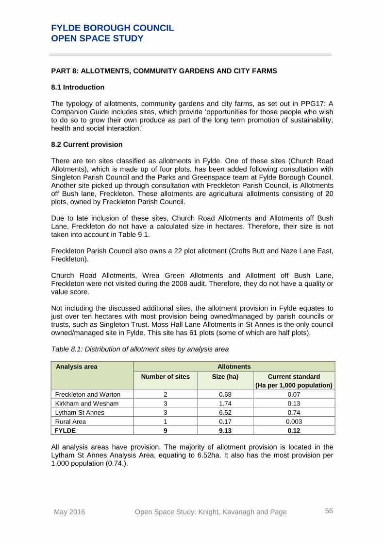
FYLDE BOROUGH COUNCIL OPEN SPACE STUDY
May 2016 Open Space Study: Knight, Kavanagh and Page 56
PART 8: ALLOTMENTS, COMMUNITY GARDENS AND CITY FARMS 8.1 Introduction The typology of allotments, community gardens and city farms, as set out in PPG17: A Companion Guide includes sites, which provide ‘opportunities for those people who wish to do so to grow their own produce as part of the long term promotion of sustainability, health and social interaction.’ 8.2 Current provision There are ten sites classified as allotments in Fylde. One of these sites (Church Road Allotments), which is made up of four plots, has been added following consultation with Singleton Parish Council and the Parks and Greenspace team at Fylde Borough Council. Another site picked up through consultation with Freckleton Parish Council, is Allotments off Bush lane, Freckleton. These allotments are agricultural allotments consisting of 20 plots, owned by Freckleton Parish Council. Due to late inclusion of these sites, Church Road Allotments and Allotments off Bush Lane, Freckleton do not have a calculated size in hectares. Therefore, their size is not taken into account in Table 9.1. Freckleton Parish Council also owns a 22 plot allotment (Crofts Butt and Naze Lane East, Freckleton). Church Road Allotments, Wrea Green Allotments and Allotment off Bush Lane, Freckleton were not visited during the 2008 audit. Therefore, they do not have a quality or value score. Not including the discussed additional sites, the allotment provision in Fylde equates to just over ten hectares with most provision being owned/managed by parish councils or trusts, such as Singleton Trust. Moss Hall Lane Allotments in St Annes is the only council owned/managed site in Fylde. This site has 61 plots (some of which are half plots). Table 8.1: Distribution of allotment sites by analysis area
Analysis area Allotments
Number of sites Size (ha) Current standard
(Ha per 1,000 population)
Freckleton and Warton 2 0.68 0.07
Kirkham and Wesham 3 1.74 0.13
Lytham St Annes 3 6.52 0.74
Rural Area 1 0.17 0.003
FYLDE 9 9.13 0.12
All analysis areas have provision. The majority of allotment provision is located in the Lytham St Annes Analysis Area, equating to 6.52ha. It also has the most provision per 1,000 population (0.74.).

FYLDE BOROUGH COUNCIL OPEN SPACE STUDY
May 2016 Open Space Study: Knight, Kavanagh and Page 57
The National Society of Allotment and Leisure Gardeners (NSALG) suggests a national standard of 20 allotments per 1,000 households (i.e. 20 allotments per 2,000 people based on two people per house) or one allotment per 200 people. This equates to 0.25 hectares per 1,000 population based on an average plot-size of 250 metres squared (0.025ha per plot). Based on the current population of 74,213 people (ONS 2014 mid-term estimates) Fylde, as a whole, does not meet the NSALG standard. Using the suggested national standard, the minimum amount of allotment provision for Fylde is 18.5 hectares. The existing provision of 9.13 hectares therefore does meet the standard. Waiting lists exist in all four analysis areas. This is not surprising when all four analysis areas, and therefore Fylde as a whole fall short of the national standard. This is further supported by consultation with, for example, Freckleton Parish Council which believes more allotment provision is needed. 8.3 Accessibility An accessibility standard of a 15 minute walk time has been set across Fylde. This is based on our extensive sector knowledge as well as reflecting best practice guidelines for allotments. Figure 8.1 shows the standards applied to allotments to help inform where deficiencies in provision may be located. Figure 8.1: Allotments mapped against analysis areas
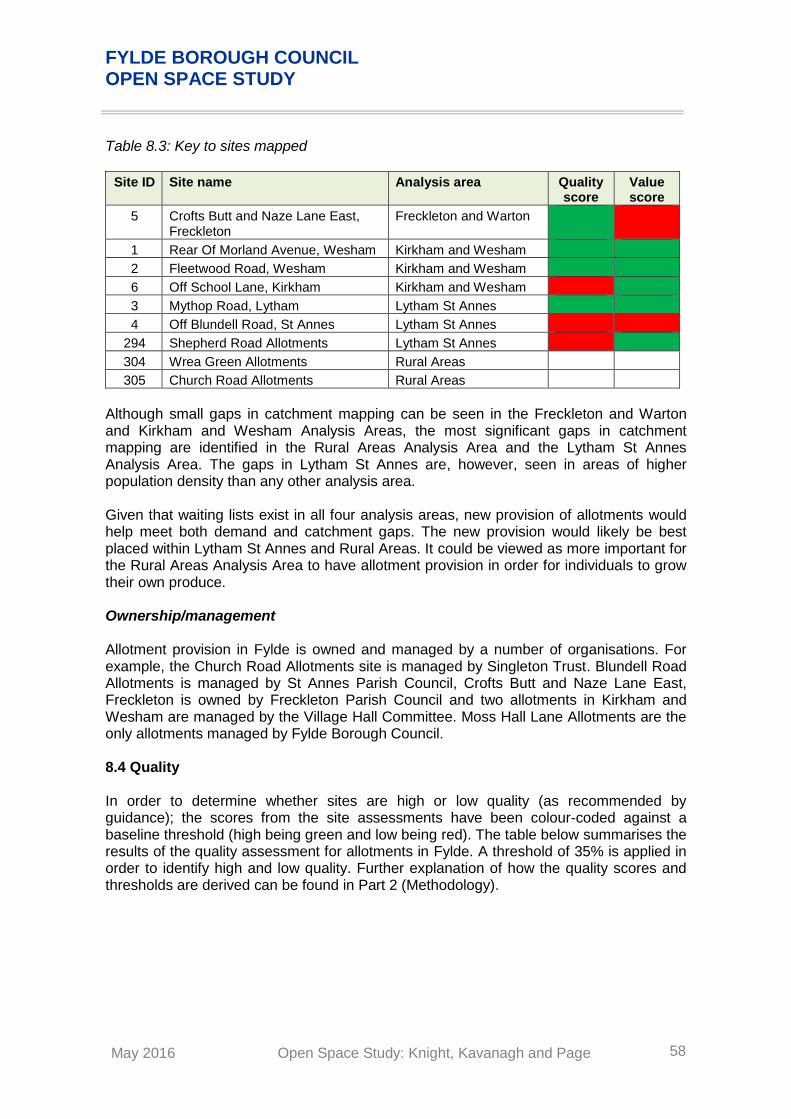
FYLDE BOROUGH COUNCIL OPEN SPACE STUDY
May 2016 Open Space Study: Knight, Kavanagh and Page 58
Table 8.3: Key to sites mapped
Site ID Site name Analysis area Quality score
Value score
5 Crofts Butt and Naze Lane East, Freckleton
Freckleton and Warton
1 Rear Of Morland Avenue, Wesham Kirkham and Wesham
2 Fleetwood Road, Wesham Kirkham and Wesham
6 Off School Lane, Kirkham Kirkham and Wesham
3 Mythop Road, Lytham Lytham St Annes
4 Off Blundell Road, St Annes Lytham St Annes
294 Shepherd Road Allotments Lytham St Annes
304 Wrea Green Allotments Rural Areas
305 Church Road Allotments Rural Areas
Although small gaps in catchment mapping can be seen in the Freckleton and Warton and Kirkham and Wesham Analysis Areas, the most significant gaps in catchment mapping are identified in the Rural Areas Analysis Area and the Lytham St Annes Analysis Area. The gaps in Lytham St Annes are, however, seen in areas of higher population density than any other analysis area. Given that waiting lists exist in all four analysis areas, new provision of allotments would help meet both demand and catchment gaps. The new provision would likely be best placed within Lytham St Annes and Rural Areas. It could be viewed as more important for the Rural Areas Analysis Area to have allotment provision in order for individuals to grow their own produce. Ownership/management Allotment provision in Fylde is owned and managed by a number of organisations. For example, the Church Road Allotments site is managed by Singleton Trust. Blundell Road Allotments is managed by St Annes Parish Council, Crofts Butt and Naze Lane East, Freckleton is owned by Freckleton Parish Council and two allotments in Kirkham and Wesham are managed by the Village Hall Committee. Moss Hall Lane Allotments are the only allotments managed by Fylde Borough Council. 8.4 Quality In order to determine whether sites are high or low quality (as recommended by guidance); the scores from the site assessments have been colour-coded against a baseline threshold (high being green and low being red). The table below summarises the results of the quality assessment for allotments in Fylde. A threshold of 35% is applied in order to identify high and low quality. Further explanation of how the quality scores and thresholds are derived can be found in Part 2 (Methodology).

FYLDE BOROUGH COUNCIL OPEN SPACE STUDY
May 2016 Open Space Study: Knight, Kavanagh and Page 59
Table 8.4: Quality ratings for allotments by analysis area
Analysis area Maximum score
Scores Spread No. of sites
Lowest score
Average score
Highest score
Low
<35%
High
>35%
Freckleton and Warton 124 37% 37% 37% 0% 0 1
Kirkham and Wesham 124 34% 36% 38% 4% 1 2
Lytham St Annes 124 26% 40% 61% 35% 2 1
Rural Area 124 0% 0% 0% 0% 0 0
FYLDE 124 25% 28% 61% 36% 3 4
In terms of quality, just over half (57%) of the assessed allotments in Fylde score highly. The highest scoring site is Mythop Road, Lytham in the Lytham St Annes Analysis Area. This site scores 61% for quality. There are three allotment sites across Fylde that rate below the threshold for quality: Shepherd Road Allotments (25%) Off Blundell Road, St Annes (26%) Off School Lane, Kirkham (34%) It is worth noting that off School Lane, Kirkham only scores just 1% under the threshold for quality. Therefore, with some small changes to maintenance this site could score above the 35% quality threshold. 8.5 Value
In order to determine whether sites are high or low value (as recommended by guidance); the scores from the site assessments have been colour-coded against a baseline threshold (high being green and low being red). The table below summarises the results of the value assessment for allotments in Fylde. A threshold of 15% is applied in order to identify high and low value. Further explanation of how the value scores and thresholds are derived can be found in Part 2 (Methodology). Table 8.5: Value ratings for allotments by analysis area
Analysis area Maximum
score Scores Spread No. of sites
Lowest score
Average score
Highest score
Low
<15%
High
>15%
Freckleton and Warton 105 8% 8% 8% 0% 1 0
Kirkham and Wesham 105 23% 29% 38% 15% 0 3
Lytham St Annes 105 9% 33% 49% 40% 1 2
Rural Area 105 0% 0% 0% 0% 0 0
FYLDE 105 8% 21% 49% 41% 2 5
The majority of assessed allotments (71%) are assessed as high value. This is a reflection of the associated social inclusion and health benefits, amenity value and the sense of place offered by such types of provision.

FYLDE BOROUGH COUNCIL OPEN SPACE STUDY
May 2016 Open Space Study: Knight, Kavanagh and Page 60
8.6 Conclusions
Summary
A total of nine sites are classified as allotments in Fylde, equating to more than 9.13 hectares which falls short of the nationally recommended amount.
Further to this, there are also waiting lists within Fylde, suggesting demand for allotments is not currently being met by supply.
Gaps in catchment mapping exist in all four analysis areas. However, the most significant gaps are in the Rural Areas and Lytham St Annes Analysis Areas. Given there are waiting lists in all four areas new provision would help with both demand and catchment gaps.
Four allotments (57%) score high for quality. Three sites score below the quality threshold. One of which is in Kirkham and Wesham, and two in Lytham St Annes analysis areas.
The majority of allotments (71%) in Fylde are assessed as high value reflecting the associated social inclusion and health benefits, their amenity value and the sense of place offered by provision.
Recommendations
Work with providers to deliver a more coordinated approach to the provision of allotments across the Borough including management of waiting lists and maintenance of sites.
Work towards increasing provision of allotments across Fylde and in particular within the Rural Areas and Lytham St Annes with continuing measures to be made to provide additional plots at existing sites.
Ensure existing sites are serviced by adequate ancillary facilities in order to allow maximised use.

FYLDE BOROUGH COUNCIL OPEN SPACE STUDY
May 2016 Open Space Study: Knight, Kavanagh and Page 61
PART 9: CEMETERIES, CHURCHYARDS AND BURIAL GROUNDS 9.1 Introduction The typology of cemeteries, churchyards and burial grounds, as set out in PPG17: A Companion Guide includes areas for ‘quiet contemplation and burial of the dead, often linked to the promotion of wildlife conservation and biodiversity.’ 9.2 Current provision There are 37 sites classified under this typology. These sites are made up of open and closed churchyards and cemeteries. Four of these sites were assessed for quality and value during the 2008 Open Space, Sport and Recreation study. Table 9.1: Distribution of cemeteries by analysis area
Analysis Area Churchyards/Cemeteries
Number of sites
Freckleton and Warton 3
Kirkham and Wesham 10
Lytham St Annes 18
Rural Area 6
FYLDE 37
Cemeteries and churchyards can be a significant open space provider in some areas particularly in rural areas. Indeed, there are a large number of sites for this type of open space due to most settlements, regardless of size, containing a church. The largest contributor to burial provision in Fylde is Lytham Park Cemetery and Crematorium which is 10.48 hectares in size. Within the identified provision there are closed churchyard sites such as Kirkham Closed Churchyard. This is a site which is no longer able to accommodate any new burials. 9.3 Accessibility
No accessibility standard is set for the typology of cemeteries and churchyards. Furthermore, there is no realistic requirement to set accessibility standards for such provision. Instead provision should be based on burial demand. Figure 9.1 shows cemeteries and churchyards mapped against the analysis area.

FYLDE BOROUGH COUNCIL OPEN SPACE STUDY
May 2016 Open Space Study: Knight, Kavanagh and Page 62
Figure 9.1: Cemetery sites mapped against analysis area
Table 9.2: Key to sites mapped
Site ID
Site name Analysis area Quality score
Value score
261 St Paul's Church, Cemetery Freckleton & Warton
313 Freckleton Methodist Church Freckleton & Warton
315 Holy Family Freckleton & Warton
173 Kirkham Closed Churchyard Kirkham & Wesham
307 Christ Church, Wesham Kirkham & Wesham
308 Christ Church, Treales Kirkham & Wesham
310 Cornerstone Kirkham & Wesham
316 Kirkham Methodist Church Kirkham & Wesham
317 Kirkham United Reformed Church Kirkham & Wesham
321 S John the Evangelist, Lund Kirkham & Wesham
329 St John the Evangelist Kirkham & Wesham
330 St Joseph, Wesham Kirkham & Wesham
334 St Michael, Kirkham Kirkham & Wesham
142 Lyhtam Park Cemetery and Crematorium
Lytham St Annes

FYLDE BOROUGH COUNCIL OPEN SPACE STUDY
May 2016 Open Space Study: Knight, Kavanagh and Page 63
Site ID
Site name Analysis area Quality score
Value score
309 Church Road Methodist Church Lytham St Annes
312 Fairhaven Methodist Church Lytham St Annes
314 Fylde Christian Service Church Lytham St Annes
318 Lytham St Anne's Free Methodist Church
Lytham St Annes
319 Mount Olivet Pentecostal Assembly Lytham St Annes
320 Our Lady Star of the Sea Lytham St Annes
322 St Alban's Lytham St Annes
325 St Annes on Sea Baptist Church Lytham St Annes
326 St Anne's-on-Sea United Reformed Church
Lytham St Annes
327 St Cuthberts Vicarage Lytham St Annes
328 St John The Divine Church Lytham St Annes
331 St Joseph's, Andsell Lytham St Annes
333 St Margaret's Parish Church Lytham St Annes
336 St Pauls Church Lytham St Annes
337 St Thomas' Church Lytham St Annes
338 The Drive Methodist Church Lytham St Annes
339 The Well Church (aka Ansdell Baptist Church)
Lytham St Annes
135 Lodge Lane, Elswick Rural Areas
311 Elswick Memorial United Reformed Church
Rural Areas
323 St Anne, Singleton Rural Areas
324 St Anne, Westby Rural Areas
332 St Lukes Mission Church Rural Areas
335 St Michael, Weeton Rural Areas
In terms of provision, mapping demonstrates a fairly even distribution across the area. As noted, the need for additional cemetery provision should be driven by the requirement for burial demand and capacity. Most respondents to the online community survey rated the amount of cemetery provision as being very satisfactory or quite satisfactory (45%). In addition, just over a quarter of respondents (26%), report being neither satisfied, nor dissatisfied with the amount of provision.
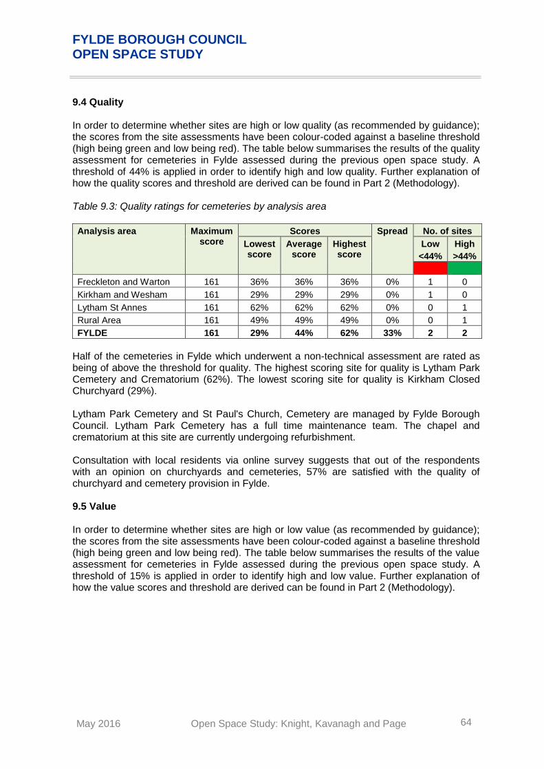
FYLDE BOROUGH COUNCIL OPEN SPACE STUDY
May 2016 Open Space Study: Knight, Kavanagh and Page 64
9.4 Quality In order to determine whether sites are high or low quality (as recommended by guidance); the scores from the site assessments have been colour-coded against a baseline threshold (high being green and low being red). The table below summarises the results of the quality assessment for cemeteries in Fylde assessed during the previous open space study. A threshold of 44% is applied in order to identify high and low quality. Further explanation of how the quality scores and threshold are derived can be found in Part 2 (Methodology). Table 9.3: Quality ratings for cemeteries by analysis area
Analysis area Maximum score
Scores Spread No. of sites
Lowest score
Average score
Highest score
Low
<44%
High
>44%
Freckleton and Warton 161 36% 36% 36% 0% 1 0
Kirkham and Wesham 161 29% 29% 29% 0% 1 0
Lytham St Annes 161 62% 62% 62% 0% 0 1
Rural Area 161 49% 49% 49% 0% 0 1
FYLDE 161 29% 44% 62% 33% 2 2
Half of the cemeteries in Fylde which underwent a non-technical assessment are rated as being of above the threshold for quality. The highest scoring site for quality is Lytham Park Cemetery and Crematorium (62%). The lowest scoring site for quality is Kirkham Closed Churchyard (29%). Lytham Park Cemetery and St Paul's Church, Cemetery are managed by Fylde Borough Council. Lytham Park Cemetery has a full time maintenance team. The chapel and crematorium at this site are currently undergoing refurbishment. Consultation with local residents via online survey suggests that out of the respondents with an opinion on churchyards and cemeteries, 57% are satisfied with the quality of churchyard and cemetery provision in Fylde. 9.5 Value In order to determine whether sites are high or low value (as recommended by guidance); the scores from the site assessments have been colour-coded against a baseline threshold (high being green and low being red). The table below summarises the results of the value assessment for cemeteries in Fylde assessed during the previous open space study. A threshold of 15% is applied in order to identify high and low value. Further explanation of how the value scores and threshold are derived can be found in Part 2 (Methodology).

FYLDE BOROUGH COUNCIL OPEN SPACE STUDY
May 2016 Open Space Study: Knight, Kavanagh and Page 65
Table 9.4: Value ratings for cemeteries by analysis area
Analysis area Maximum score
Scores Spread No. of sites
Lowest score
Average score
Highest score
Low
<15%
High
>15%
Freckleton and Warton 100 26% 26% 26% 0% 0 1
Kirkham and Wesham 100 20% 20% 20% 0% 0 1
Lytham St Annes 100 31% 31% 31% 0% 0 1
Rural Area 100 29% 29% 29% 0% 0 1
FYLDE 100 20% 27% 31% 11% 0 4
The cemeteries and churchyards in Fylde which underwent a non-technical assessment are assessed as being of high value, reflecting the role they provide in communities lives. In addition, the cultural/heritage value of sites and the sense of place they provide to the local community. The highest scoring site for value is Lytham Park Cemetery and Crematorium. This can be attributed to both its size and heritage. This heritage is important to the local community and being protected through refurbishment of the onsite chapel. 9.6 Conclusions
Summary
There are 37 sites classified as churchyards or cemeteries.
The largest contributor to burial provision in Fylde is Lytham Park Cemetery and Crematorium which is 10.48 hectares in size.
Out of the assessed provision, two cemeteries and churchyards are rated as high quality: Lytham Park Cemetery and Crematorium and Lodge Lane, Elswick. The highest scoring site for quality is Lytham Park Cemetery and Crematorium (62%).
All cemeteries assessed are of high value in the Borough, reflecting that generally provision has cultural/heritage value and provide a sense of place to the local community. It is more than likely that all non assessed cemeteries will also be of high value.
Recommendations
Provision of cemeteries and burial provision in Fylde should continue to be driven by the demand for burials and assessment of available capacity.
Consider the future application of Lytham Park Cemetery and Crematorium within the Green Flag Award Scheme.

FYLDE BOROUGH COUNCIL OPEN SPACE STUDY
May 2016 Open Space Study: Knight, Kavanagh and Page 66
APPENDIX 1: COMMUNITY SURVEY SUMMARY The following provides a summary of the responses received from the online community survey. Fylde Borough Council publicised the online survey through its website. A total of 214 individuals responded to the survey, although not every respondent completed all of the questions. Usage and value Participants were asked how often they visited open space provision within Fylde. Most respondents (73%) identify that they visit open space more than once a week. This highlights the importance of open space to local residents. Figure 10.1: How often do you visit/use any open spaces or outdoor recreational facilities in Fylde
It is reported that open space, in particular parks and gardens, are used for meeting up with friends, walking dogs, unorganised sport such as football, walking, and running (including organised events such as parkrun at Lytham Hall Park). This question was followed by asking respondents which types of open space provision they use most often. Most respondents report that they visit typologies such as promenades (59%), beaches (43%) and parks and gardens (47%) more than once a week. Respondents also identify that they use green corridors such as footpaths and cycle paths (65%) more than once a week. This indicates the popularity of natural and semi natural provision as well as parks and gardens and civic spaces within Fylde. Cemeteries and churchyards, allotments and play provision for teenagers are visited less frequently. Most respondents report using cemeteries and churchyards either once a month (31%) or never (33%), play provision for teenagers never (60%) and allotments never (82%). This could be attributed to provision such as allotments only being used by individuals with a specific interest, and churchyards and cemeteries existing for a specific purpose.

FYLDE BOROUGH COUNCIL OPEN SPACE STUDY
May 2016 Open Space Study: Knight, Kavanagh and Page 67
Figure 10.2: How often have you visited/used each of the following in Fylde in the last 12 months?
The most popular sites within Fylde, highlighted during public consultation are Lytham Hall Park, Park View, Ashton Gardens, Fairhaven Lake, the beach and Lowther Gardens. These qualitative findings are further supported by the quantitative results, with the open space provision reported to be most important to residents of Fylde are promenades (86%), parks and gardens (86%), beaches and dunes (84%), footpaths and cycle paths (79%) and nature areas (74%). Figure 10.3: How important are the following types of spaces to you?

FYLDE BOROUGH COUNCIL OPEN SPACE STUDY
May 2016 Open Space Study: Knight, Kavanagh and Page 68
Amount and Availability The majority of respondents identify the amount and availability of open space provision to be either very satisfactory or quite satisfactory. The typologies of open space provision reported to be least satisfactory (not very satisfied) for amount and availability are footpaths and cycle paths (27%) and play provision for teenagers (26%). Figure 10.4: How satisfied are you with the amount/availability of the following types of space in the area where you live
Accessibility The willingness to travel to open space provision is dependent upon the typology. For example, a higher number of respondents are willing to travel over 45 minutes to access nature areas (14%), beaches (9.8%) and parks and gardens (9.1%). However, for childrens play areas, amenity green space (grassed area on housing estate) and allotments less respondents report wanting to travel over 45 minutes. This is understandable as residents will use more local facilities for these typologies. A high proportion of respondents identify being willing to travel up to 15 minutes to access most types of open space provision.

FYLDE BOROUGH COUNCIL OPEN SPACE STUDY
May 2016 Open Space Study: Knight, Kavanagh and Page 69
Figure 10.5: How long are you willing to spend travelling to each of the following types of space
Consultation with residents did highlight some issues with access to open spaces. A high number of respondents report wanting to see improvements to paths, bridal ways and cycle paths and their linkage of green infrastructure. Quality Overall respondents consider the quality of provision to be either very satisfactory or quite satisfactory. The typologies scoring the highest for quality (combining very satisfied and quite satisfied responses) are promenades (84%), beaches (83%) and parks and gardens (70%). The typologies reported to be of lowest quality are play provision for teenagers (31%) and footpaths and cycle paths (35%). The resident’s view of teenage provision being of low quality could be linked to the fact that teenage provision is one of the least frequently visited typologies. Figure 10.6: How satisfied are you with the quality of the following types of space in the area where you live

FYLDE BOROUGH COUNCIL OPEN SPACE STUDY
May 2016 Open Space Study: Knight, Kavanagh and Page 70
In order to increase quality and user satisfaction of open spaces, Fylde residents report wanting to see: More controls to prevent dog fouling e.g. dog play areas within parks Controls to prevent anti social behaviour Better facilities for children and young people Increased signage providing information about wildlife and the heritage of the area in
particular on the beach. When residents were asked what they viewed as most important for open spaces in Fylde, the most common responses were: Community involvement and events Attractiveness of sites e.g. plants and trees Cleanliness of sites Regular maintenance and improvements to sites Protection of existing wildlife areas Introduction of new wildlife areas Feeling safe e.g. lighting and fencing Preventing reductions in open space through developments