furnace creek springs restoration and adaptive management ... · furnace creek springs restoration...
TRANSCRIPT

Furnace Creek Springs Restoration and Adaptive Management Plan, Death Valley National Park, California Donald W. Sada1 David J. Cooper2
February 2012
prepared by 1Desert Research Institute, Nevada System of Higher Education, Reno, Nevada and 2Department of Forest and Rangeland Stewardship, Colorado State University, Fort Collins, Colorado 80523
prepared for
U.S. National Park Service, Death Valley National Park, Death Valley, California

THIS PAGE INTENTIONALLY LEFT BLANK

iii
CONTENTS
LIST OF FIGURES ........................................................................................................................ v LIST OF TABLES ......................................................................................................................... vi INTRODUCTION .......................................................................................................................... 1 BACKGROUND ............................................................................................................................ 3 HISTORICAL AND EXISTING SPRING CHARACTERISTICS ............................................... 5
Spring Environments ................................................................................................................ 6 Travertine Springs ............................................................................................................... 6 Texas Spring ....................................................................................................................... 9 Nevares Springs .................................................................................................................. 9
Spring Ecology........................................................................................................................ 12 Aquatic Ecology...................................................................................................................... 12 Riparian Ecology .................................................................................................................... 15
WATER CHEMISTRY AND TRAVERTINE DEPOSITION .................................................... 20 SPRING DISCHARGE ................................................................................................................ 22
Summary ................................................................................................................................. 25 SPRING RESTORATION............................................................................................................ 26
Restoration Goals .................................................................................................................... 27 Restoration Guidelines ............................................................................................................ 27
HYDROLOGIC RESTORATION ............................................................................................... 30 Recommendations and Practical Considerations .................................................................... 30 Travertine Springs ................................................................................................................... 31
Travertine No. 1 ................................................................................................................ 31 Furnace Creek Wash Ditch ............................................................................................... 31 Travertine No. 2 ................................................................................................................ 32 Travertine Nos. 3 and 4 ..................................................................................................... 32
Texas Spring ........................................................................................................................... 33 Restoration Alternatives.......................................................................................................... 35
TRAVERTINE SPRINGS ............................................................................................................ 36 Travertine Springs – No Action Alternative ........................................................................... 37
Restoration Program ......................................................................................................... 37 Environmental and Biotic Consequences ......................................................................... 37
Travertine Springs – Moderate Alteration Alternative ........................................................... 37 Restoration Program ......................................................................................................... 37 Environmental and Biotic Consequences ......................................................................... 38
Travertine Springs – Major Alteration Alternative ................................................................. 38 Restoration Program ......................................................................................................... 38 Environmental and Biotic Consequences ......................................................................... 39
TEXAS SPRING .......................................................................................................................... 39 Texas Spring—No Action Alternative.................................................................................... 40
Environmental and Biotic Consequences ......................................................................... 40 Texas Spring—Moderate Alteration Alternative .................................................................... 41
Restoration Program ......................................................................................................... 41 Environmental and Biotic Consequences ......................................................................... 41
Texas Spring—Major Alteration Alternative ......................................................................... 41 Restoration Program ......................................................................................................... 41

iv
Environmental and Biotic Consequences ......................................................................... 41 NEVARES SPRINGS ................................................................................................................... 42 ADAPTIVE MANAGEMENT TO ACHIEVE AND ASSESS RESTORATION SUCCESS .... 42
Guidelines ............................................................................................................................... 42 Monitoring Methods and Strategies ........................................................................................ 45
Groundwater Hydrology and Spring Discharge, Richard Friese, DEVA ......................... 45 Soil Moisture and Vegetation Monitoring, David J. Cooper, CSU .................................. 45 Aquatic System Monitoring, Donald W. Sada, DRI ......................................................... 46 Aquatic Habitat Monitoring .............................................................................................. 48 Aquatic Habitat Sampling Field Equipment ..................................................................... 49 BMI Sampling ................................................................................................................... 49 Short-Term BMI Monitoring ............................................................................................ 53 Long-Term BMI Monitoring ............................................................................................ 54 BMI Sampling Field Equipment ....................................................................................... 54
ACKNOWLEDGEMENTS .......................................................................................................... 54 REFERENCES ............................................................................................................................. 55

v
LIST OF FIGURES
1. Location of the Furnace Creek Springs in Death Valley National Park. .................................. 2 2. Schematic drawing of the Travertine Springs Province. .......................................................... 7 3. Substrate composition of the Travertine Spring No. 1 springbrook as indicated by the
presence and absence of fines, armored travertine, and a mixture of both (Sada and Herbst 2006).............................................................................................................................. 8
4. Texas Spring water distribution system in 1989 (left) and 2009 (right). .................................. 9 5. Schematic drawing of the Nevares Springs travertine mound and the two springs
discharging from it. ................................................................................................................. 10 6. Nevares Springs showing the travertine mound (top left), the top of the mound
illustrating the two main wetland areas (top right), and the characteristic herbaceous vegetation (bottom). ................................................................................................................ 11
7. BMI density and species richness from source to terminus of Travertine Spring No. 1. ....................................................................................................................................... 13
8. BMI density and species richness from source to terminus of Nevares Springs .................... 13 9. Springsnail density and its numeric proportion of the BMI community in Travertine
Spring No. 1. ........................................................................................................................... 13 10. Springsnail density and its numeric proportion of the BMI community in Nevares
Spring. ..................................................................................................................................... 13 11. The proportion of crenobiontics and non-crenobiontics (exclusive of springsnails)
along the gradient from source to terminus of Travertine Spring No. 1. ................................ 14 12. The proportion of crenobiontics and non-crenobiontics (exclusive of springsnails)
along the gradient from source to terminus of Nevares Spring. ............................................. 14 13. Agglomerative cluster analysis of vegetation data from the Nevares/Travertine
Springs complexes in Death Valley National Park. ................................................................ 16 14. Depth to the water table plots for Nevares Springs. ............................................................... 17 15. Continuous groundwater levels and water temperatures for wells 32, 41, 43 and 64 at
Travertine Springs. .................................................................................................................. 18 16. Location of monitoring wells at the upper Travertine 1 complex (left panel). Hand
read depth to water table, or head measures for wells and piezometers along Transect 1 (T1). ....................................................................................................................... 20
17. Temperature and pH recorded from the source to 200 m downstream in Travertine No. 1 Spring during March 2009. ........................................................................................... 21
18. The amount of CO2 degassed along the upper 200 m (relative to the total amount degassed in this reach, not relative to the total amount available for degassing from the spring water) Travertine Spring No. l during March 2009. .............................................. 22
19. Mean and variance of Travertine Spring No. 1 springbrook wetted width at five discharge rates measured during March 2008 field experiments ............................................ 24
20. Mean and variance of Travertine Spring No. 1 springbrook water depth at five discharge rates measured during March 2008 field experiments. ........................................... 24

vi
21. Mean and variance of Travertine Spring No. 1 springbrook mean water column velocity at five discharge rates measured during March 2008 field experiments ................... 25
21. A) 10 cm X 20 cm brass quadrat, B) 10 cm X 20 cm brass quadrat with 10 cm X 20 cm, 250 µm mesh dipnet. ........................................................................................................ 50
22. Rarefaction curves showing the cumulative number of species collected in the Travertine Spring Province and Nevares Springs as reported by Sada and Herbst (2006) for 1998 spring time samples, and during winter 2010 by Sada for this restoration plan........................................................................................................................ 51
LIST OF TABLES
1. Water depth, mean water column velocity, and channel wetted width range and variance observed in Travertine No. 1 and its tributary springs by Sada and Herbst (2006). ..................................................................................................................................... 49
2. The total number of 10 cm X 12 cm spring time samples taken by Sada and Herbst (2006), and the number of samples within the upper 30 m of habitat of Travertine and Nevares Springs to capture all endemic species known from each spring during the spring time......................................................................................................................... 53

1
INTRODUCTION
Sada and Pohlmann (2007) documented almost 800 springs in Death Valley National Park. They occur throughout the Park, from below sea level on the valley floor to almost 11,000 feet elevation in the Panamint Mountains. Some springs dry periodically, while others are reliable water sources that have flowed for millennia. Death Valley springs also support fish and aquatic macroinvertebrates that are endemic to the Park (Sada et al. 1995). Mountain and valley floor springs are supplied by seasonal precipitation falling within the Park, and regional aquifer springs that have flowed for millennia are supplied by a regional aquifer fed by paleo-infiltration in distant mountains lying to the east and northeast (Bedinger and Harrill 2008). Regional aquifer springs, including the Furnace Creek Springs (Travertine, Texas, and Nevares springs), have historically provided most of the water for visitor services and National Park Service activities at Furnace Creek and Cow Creek (Figure 1). These springs also support mesquite woodlands, other riparian and wetland vegetation, and five aquatic macroinvertebrates that occur nowhere else (Baldinger et al. 2002; Hershler 2001; Shepard 1992; Polhemus and Polhemus 2002, Thomas 2006).
The National Park Service completed an Environmental Impact Statement to upgrade a system of spring diversions that supply water from Travertine and Texas springs to Park and visitor facilities at Furnace Creek in 2006 (U.S. National Park Service 2006). This project includes returning surface flow that has been captured and piped for municipal use from Travertine and Texas springs for several decades, and restoring their historical biological condition. Restoration in context of this plan includes returning spring hydrology and characteristics of the aquatic and riparian communities to conditions that are believed to lie within the range of natural variability. This plan describes restoration goals, current biotic and abiotic conditions, presumed historical reference conditions as indicated by aquatic and riparian vegetation studies, and salient biological indicators of restoration progress and success. Factors that are most likely to challenge restoration success, and methods to manage these challenges, are also discussed.
Restoration goals and indicators described in this plan have been determined by studies conducted over the past 10 years. This plan compiles information from this work and integrates it to guide restoration and justify its goals and identify indicators to assess restoration progress. Accomplishing restoration requires adaptive management that incorporates information provided by monitoring to assess program efficacy and inform management decisions that are necessary to successfully achieve restoration. This plan provides guidance to achieve restoration. However, engineering and construction complexities that may be required to fully achieve restoration (primarily spring source restoration) are beyond the scope of this restoration plan.

2
Figure 1. Location of the Furnace Creek Springs in Death Valley National Park.

3
BACKGROUND Springs support aquatic and riparian systems where groundwater reaches the land surface through natural processes (Meinzer 1923). They provide much of the aquatic environment in arid lands as well as a substantial portion of regional aquatic and riparian biodiversity (Hubbs 1995; Anderson and Anderson 1997; Myers and Resh 1999). As a consequence of their lengthy isolation and long-term persistence, many arid land springs also support a crenobiontic (obligate spring dwelling) and endemic fauna and flora (e.g., Erman and Erman 1995; Hershler 1998; Schmude 1999; Baldinger et al. 2000; Polhemus and Polhemus 2002, Hershler and Liu 2008). When they are persistent, springs are generally more stable than lotic systems because they are not exposed to seasonal variability in temperature and discharge (Mattson et al. 1995). Variability in population size and assemblage structure of aquatic life in persistent springs is low compared to other aquatic systems, and springs are often occupied by animals that cannot occupy highly variable environments (Minckley 1963; van der Kamp 1995). Arid land springs are distinct from springs in more temperate or humid regions because they are typically isolated from other waters, some are susceptible to drought, and aquifers in these regions are strongly influenced by recharge from high elevations, rugged topography, and diverse lithology (Thomas et al. 1996; Patten et al. 2008). Geology, aquifer size, geography, climate, and the persistence of water constitute the hydrologic context for each spring. These factors also provide the fundamental natural elements that influence spring environments and structure biotic communities.
A number of hydrologic and biological studies have examined arid land springs, but little attention has been given to integrating groundwater hydrology, physiochemical aspects of spring environments, and the characteristics of aquatic and riparian communities. Understanding the interactions among these factors is necessary to develop integrated models to assess how the relationships between natural disturbance regimes and anthropogenic uses influence spring ecosystems. This information is also necessary to design and implement restoration programs.
Ecological studies of arid land springs in the western U.S. have lagged behind studies of other aquatic systems. Most work has focused on biogeography, systematics, taxonomy, and conservation biology of fishes (e.g., Hubbs et al. 1974; Naiman and Soltz 1981; Williams et al. 1985) and the taxonomy and biogeography of springsnails (e.g., Hershler 1998; Hershler et al. 1999; Hershler and Sada 2002), although a few studies of spring plants and vegetation also exist (Thomas 2006; Patten et al. 2008a, b). Ecological studies of benthic macroinvertebrates (BMIs) in these ecosystems found that their community structure is influenced by habitat characteristics (e.g., water velocity, temperature, substrate composition, water temperature, and environmental variability) that change along a continuum from the spring’s source to its terminus where water evaporates, infiltrates the ground, or enters a larger aquatic ecosystem (Meffe and Marsh 1983; Heyford et al. 1995; Sada and Herbst 2006).

4
Stressing factors such as high temperature, chemically harsh water, the frequency of drying and human-caused disturbance also influence species and communities. The magnitude of influence that these factors have on aquatic and riparian communities is a function of the frequency, duration, and severity of stressing factors at a spring. Persistent, minimally disturbed springs with good water quality generally support higher species richness and species that are intolerant of harsh conditions. These characteristics generally change along a gradient as stress increases, such that highly stressed springs support depauperate communities composed of animals and plants that are tolerant of harsh physicochemical environments (Sada et al. 2005; Fleishman et al. 2006).
Travertine, Texas, and Nevares springs (collectively referred to as the Furnace Creek Springs) and springs in nearby Ash Meadows, Nevada, are located at the southern end of a carbonate rock province that forms the Lower Carbonate Aquifer that encompasses the western two-thirds of the Great Basin (Bedinger and Harrill 2008; Hershey et al. 2009) (Figure 1). Concentrations of Ca+2, Mg+2, HCO3
-, Na+, and CO2 are characteristically high in this aquifer and the temperature of Furnace Creek Springs range from 32oC to 40oC. Additionally, pH at the sources is constantly 7.4, electrical conductance (EC) is approximately 1,200 µmhos, concentrations of many trace elements are similar among springs, and discharge is relatively constant (Kreamer et al. 1996, Hershey et al. 2008). Travertine and Nevares springs are provinces of more than one spring, and the Furnace Creek Springs are naturally fishless, support a diversity of Death Valley endemic benthic macroinvertebrates (BMIs) (as well as widely distributed BMIs), and herbaceous and woody wetland and riparian vegetation (Sada and Herbst 2006; Thomas 2006).
Although the Furnace Creek Springs are supplied by one aquifer, discharge from each spring province is influenced by local lithology. Nevares Springs is the lowest elevation province of these springs, and it is the furthest west expression of the Lower Carbonate Aquifer (LCA) as a continuous unit. These springs discharge directly from the carbonate bedrock and travertine deposition has built its spring mound as an outward and upward projection from the bedrock. The top of this mound is approximately100 m west of an outcrop of the carbonate bedrock. Nevares Springs are located at this site because the carbonate rock aquifer is truncated by faulting, juxtaposing the aquifer against very low permeability rocks of the lower clastic confining unit. The exact mechanism by which water reaches the surface is unknown. However, based on U.S. Geological Survey descriptions of similar situations, the majority of the flow is probably contained within several primary flow paths that act as pipes to the surface. The regional flow model classifies the spring as a deep drain with a direct connection to the LCA in model layer 10 (Belcher and Sweetkind 2010).
Travertine and Texas springs are different systems. At these sites, groundwater has exited the carbonate rock aquifer several miles upgradient where the Furnace Creek Fault zone ruptures the southwest face of the Funeral Mountains. From there, groundwater flows through basin fill alluvial sediments of the Funeral Formation and the underlying, much less permeable,

5
Furnace Creek Formation. Travertine Springs, Texas Spring, and numerous small unnamed springs discharge from the Funeral Formation along an arc that appears to be related to a small-scale thrust fault within the basin fill sediments, and also the truncation of the more permeable Funeral Formation sediments by the less permeable Furnace Creek Formation sediments (Machette et al. 2000). Contact between the two units is depositional and strata were downwarped into a synclinal structure resulting in high-angle contacts with possible small-scale reverse faulting along the western limb.
All Furnace Creek Springs have been disturbed to provide water for human domestic and municipal uses, and diversions from Texas Spring and the two largest Travertine Springs dried these springs for a number of decades (Threloff and Koenig 1999; U.S. National Park Service 2005; Sada and Herbst 2006). The most southerly Travertine Springs were not completely developed, and some areas are in good, and perhaps reference condition. Water from Texas Spring was recently released onto the land surface and this portion of its newly wetted channel area is naturalizing from being dry for many decades. The National Park Service is changing the domestic water delivery from springs with groundwater pumped from nearby wells (U.S. National Park Service 2006). These wells have been pumping since 7 April 2009, and the goal is to cease using water diverted at the sources of Texas Springs and Travertine Springs, and restore spring hydrologic regime, biotic composition, and ecological functioning. No decreases in spring discharge have been noted at this time; however, Bredenhoeft et al. (2005) predicted that flow reductions may be as large as 26 percent at Travertine Springs and 17 percent at Texas Spring.
Riparian and aquatic communities can be structured by a number of biological (e.g., competition, predation, etc.) and environmental factors (e.g., climate, lithology, hydrologic regime, salinity, topography, etc.). The variety of biological and environmental interactions is wide, highly variable, and each system is unique. Because of this diversity, understanding the biotic communities and environmental factors that most influence their structure is critical for successfully designing restoration programs. In light of these concepts, restoring the Furnace Creek Springs requires: (1) understanding the relationships between spring biota and physicochemical characteristics of the aquatic and riparian environments, (2) understanding the ecological effects of environmental stressors that have degraded these spring ecosystems, (3) understanding how aquatic and riparian systems will respond to restoration, (4) identifying restoration goals, and (5) implementing appropriate management strategies to achieve restoration. This restoration plan addresses all of these elements.
HISTORICAL AND EXISTING SPRING CHARACTERISTICS With the exception of taxonomic descriptions of endemic macroinvertebrates, prior to 2000 there was a paucity of information describing either the environments or biota of the Furnace Creek Springs. Furthermore, a search of historic photographs in Death Valley National Park archives yielded little helpful insight about the pre-disturbance condition of these springs. Although human activity has altered these springs, most activity occurred more than 30 years

6
ago and the functional characteristics of some riparian and aquatic communities appear to have reestablished at Nevares Springs and the most southerly Travertine Springs. This naturalization has occurred because: (1) disturbance appears to have been infrequent, often minimal, and some portions of the spring complexes have been unaffected, and (2) most springs are interconnected and aquatic organisms can readily recolonize from undisturbed habitats. The following description of historic physical, chemical, and biological characteristics of the Furnace Creek Springs is compiled from: (1) familiarity with other carbonate aquifer springs in the region, (2) assessment of how past disturbance is likely to have altered the springs and their biota, (3) studies quantifying relationships between BMI communities and physicochemical characteristics of Furnace Creek Springs and their springbrooks, and (4) studies examining relationships between soil, water, and Furnace Creek Springs riparian vegetation.
Spring Environments Travertine Springs
Travertine Springs is a province of springs in an area encompassing approximately 35 hectares collectively that discharge the largest amount of potable water available in Death Valley (Figure 2). The province is on a southward sloping bajada, with the highest spring in the province near 120 m elevation and the lowest spring is near 70 m elevation. These springs have been a focal point of human activity since the mid-1800s when they were first used for municipal and mining uses at Furnace Creek (Lingenfelter 1986). The province includes seven flowing springs, and three springs whose discharge is captured in subterranean spring boxes. Water from existing and historic springs either connected as they crossed the bajada or after flowing into Furnace Creek Wash. Whether or not 10 springs historically flowed in the area is unknown, but it is probably an accurate estimate because three springs are presently diverted and dry, and Sada and Herbst (2006) sampled six flowing springs (including a total of 1,150 m of spring channels) in the late 1990s (one spring was not sampled by Sada and Herbst). Many springbrooks have also been excavated to increase flow and divert surface water, and scattered pieces of old, rusty pipe, several spring boxes, and debris from spring excavation are remaining evidence of past human activity. The largest and highest spring in the province (Travertine No. 1) flows from a springbox, however, its springbrook and biotic community appear to have naturalized. It is tributary to several lower springs (near Hwy 190) that appear to be relatively undisturbed. It appears that these sites may have functioned as refuges for aquatic life when other springs in the province were dried and diverted.
Winograd (1971) estimated total discharge from the province to be 3,200 liters/minute (lpm) (845 gallons/minute [gpm]) with discharge from individual springs ranging from less than 2 lpm to more than 1,500 lpm (400 gpm). The largest four springs are named numerically; Travertine Spring No. 1 is the highest spring in the province. It currently discharges approximately 340 lpm (90 gpm) from a springbox and flows more than 500 m into Furnace

7
Creek Wash. Travertine Springs No. 2, 3, and 4 have been captured and diverted for Furnace Creek domestic use for decades and they are the focus of this restoration program. These springs discharge(d) between approximately 1,500 lpm (400 gpm) and 750 lpm (200 gpm), respectively. Historically, these springs also flowed into Furnace Creek Wash and the length of their springbrooks were estimated to have ranged from approximately 150 m to 700 m. All flow from existing springbrooks is combined into a small concrete channel that parallels Hwy. 190, then diverted into Furnace Creek Wash through a culvert under the highway. This diversion is necessary to prevent spring water from adversely affecting the highway.
Figure 2. Schematic drawing of the Travertine Springs Province. Blue lines represent
existing springbrooks, and light blue, dashed lines represent possible springbrook routes that will exist when discharge from Travertine Springs 2, 3, and 4 are released onto the land surface.
Although there are no historic records quantifying the biological characteristics of Travertine Springs, insight into their likely benthic macroinvertebrate (BMI) community was compiled from investigations in what appeared to be good quality springbrooks at Travertine and Nevares springs by Sada and Herbst (2006). These springbrooks may have been disturbed in the distant past, but currently appear healthy. All existing springbrooks in the Travertine Springs complex were sampled by Sada and Herbst (2006). They found channels to be relatively narrow near their sources (10 cm to 50 cm) and widen downstream (up to 1,200 cm). They are mostly shallow (1 cm to 5 cm) with a current velocity up to 39 cm/sec.

8
Substrate composition included fines, sand, gravel, and armored travertine. Substrate composition in Travertine Spring No. 1 changed along a downstream gradient where the upper 50 m was fines and sand and armored travertine was the only substrate from 50 m to approximately 200 m downstream. A mixture of fines and armored travertine occurred from 200 m to Furnace Creek Wash (Figure 3). Source water temperatures ranged from 32°C to 34°C and electrical conductance ranged from 810 µmhos to 1,150 µmhos.
With the exception of two exotic tree species, fan palm (Washingtonia fillifera) and date palm (Phoenix dactylifera), the vegetation of Travertine Springs riparian ecosystem was mostly composed of native plant species, and was intact until August 2010 when the area burned following accidental disposal of a cigarette. Woody vegetation burned in the area, and all palms were mechanically removed from the spring province in February 2011.
Vegetation studies conducted before the fire found that where ground water is within 1 m to 3 m of the ground surface saltgrass (Distichlis spicata), arrowweed (Pluchea sericea) and Baccharis (Baccharis sergiloides) dominate the vegetation. Where ground water discharges to the ground surface and channels have formed a characteristic suite of herbaceous wetland plant species are present including spikerush (Eleocharis rostellata), bulrush (Scirpus americanus), rush (Juncus cooperi), and the sedge Fimbristylis thermalis. Patches of cattail (Typha domingensis) may also occur in the channel or flooded areas. Bosques occur on rocky substrate with deeper water tables, and are dominated by honey and screwbean mesquite (Prosopis pubescens and P. glandulosa). The vegetation of the Travertine Spring complex was described by Thomas (2006).
Figure 3. Substrate composition of the Travertine Spring No. 1 springbrook as indicated by
the presence and absence of fines, armored travertine, and a mixture of both (Sada and Herbst 2006). Data from BMIs sample quadrats.

9
Texas Spring
Texas Spring is located approximately 1.5 km northwest of Travertine Springs at approximately 120 m elevation. Estimated historical discharge is 850 L/min (Winograd 1971). It historically flowed more than 1,500 m onto the Death Valley floor near Furnace Creek Ranch (Threloff and Koenig 1999). The site currently bears little resemblance to its historic, undisturbed condition and all of its discharge currently flows from a pipe that extends from a trench that was dug into a spring mound created by its source during the early 1900s. It is difficult to determine historic characteristics of the spring source because construction of the trench eliminated any evidence indicating it natural characteristics. Additionally, no historical photographs were found during a search of Death Valley National Park archives. Although its mound appears to be similar to the travertine mound at Nevares Springs, there is no evidence of travertine on its surface. Diversion from Texas Springs continued until the early 2000s when it stopped because water quality standards for coliform bacteria for domestic use of water could not be met. The spring mound is currently bare soil, without evidence of recent water. When diversion ceased, all of its discharge was passed through a pipe and discharged onto the soil approximately 30 m downstream from the trench. Although riparian vegetation, primarily mesquite plants, expanded in size, or new individuals established along 150 m of springbrook below the pipe (Figure 4), erosion below this point created an incised channel that is up to 5 m deep.
Figure 4. Texas Spring water distribution system in 1989 (left) and 2009 (right). The honey
mesquite have grown larger since water was released to the ground. In addition, populations of Baccharis sergiloides, Pluchea sericea, Eleocharis rostellata and Scirpus americanus have colonized channels.
Nevares Springs
Nevares Springs consists of several small, helocrene springs that combine and discharge from the top of a travertine mound that is elevated approximately 15 m above the surrounding bajada (alluvial fan) (Figures 5 and 6 bottom photo). It is difficult to determine if

10
this springbrook follows its historical route or if its current route has been created through excavation. A separate, small spring also discharges from an adit that has been excavated into the base of the mound (Figure 5). Springs atop the mound have been modified by a single springbox that collects water for U.S. National Park Service employee Cow Creek housing area. Diversions through this springbox have decreased surface discharge an unknown amount. These springs appear to have ‘naturalized’ from past disturbance (springbox installation and excavation), and a nearby well was recently drilled for scientific purposes (to measure groundwater levels). This well may eventually replace the springbox as a source of domestic water. Evidence that this spring has been modified is also indicated by a dry trench that historically directed water to a small historic ranch house and orchard that is located near the springbrook terminus that is associated with the spring discharging from the side of the travertine mound. Although springs on top of the mound have been altered, this area now supports a well developed system of wetland vegetation.
Figure 5. Schematic drawing of the Nevares Springs travertine mound and the two springs
discharging from it.
A characteristic suite of native herbaceous species dominate the wetland vegetation atop the mound, including Schoenus nigricans, Eleocharis rostellata, Juncus cooperi, Scirpus americanus, Andropogon glomeratus, and the orchid Epipactis gigantea (Figure 6). Mesquite borders the springbrook that flows from the mound to the valley bottom on the south. Mesquite also formerly occurred on the northern side of the mound, but these have all died for unknown reasons. The channel enters a deep valley before entering Cow Creek. The

11
lower portions of the channel system are periodically scoured by floods. The channel is approximately 250 m long, and its flow percolates into alluvium approximately 120 m below its entrance into the scoured channel. The channel is comparatively narrow, shallow, and swift. There is a wide diversity of substrate types in the habitat, but fines, travertine, and solid travertine are the most common substrate types. When the Cow Creek potable water tanks are full, diversion decreases causing discharge from the excavated spring that flows south and west approximately 150 m and spreads over a marsh area that supports cattails, mesquite, and palm trees before it dries. This spring is isolated and not connected to other Nevares Springs. Smaller size classes dominate the substrate, and the aquatic habitat is shallow, comparatively swift near the source and placid near its terminus (Sada and Herbst 2006).
Nevares Springs were sampled by Sada and Herbst (2006). Similar to Travertine Springs, channels were narrow (generally 10 cm to 50 cm) and wider in a few areas (up to 500 cm). They were typically shallow (1 cm to 5 cm) with current velocities ranging from 2 cm/sec to 46 cm/sec aquatic habitat. Substrate composition also included fines, sand, gravel, and armored travertine. Source water temperatures ranged from 33.5°C to 40°C and electrical conductance ranged from 1,180 µS to 1,210 µS.
Figure 6. Nevares Springs showing the travertine mound (top left), the top of the mound
illustrating the two main wetland areas (top right), and the characteristic herbaceous vegetation (bottom).

12
Spring Ecology Examination of the relationships between biological and environmental characteristics of aquatic and riparian systems associated with naturalized, or apparently natural Furnace Creek springs provides insight into natural conditions and provides a strong foundation to design appropriate restoration programs and determine goals and targets for successful restoration. The following discussion summarizes physicochemical and biological characteristics of Furnace Creek Springs that are most relevant to restoration. Information for this summary is from studies by Sada and Herbst (2006) in the late 1990s, and by studies examining soil water/riparian vegetation interactions and studies examining the cascading influence of changes in water chemistry from spring source to terminus on the structure of BMI and riparian communities.
Aquatic Ecology Sada and Herbst (2006) studied BMI ecology in Travertine and Nevares springs. No studies have examined Texas Spring aquatic biology. They documented a total of 50 and 37 species in these springs, respectively, and the structure of BMI communities at both sites was similar. Travertine Springs supported populations of all endemic BMIs (e.g., Ipnobius robustus [a springsnail], Hyalella sandra, Hyallela mureta [amphipod crustaceans], Microcylloepus formicoideus [an aquatic beetle], and Ambrysus funebrus [an aquatic true bug]), but H. muerta was not found in Nevares Springs. The presence and distribution of these species in Furnace Creek Springs has also been recorded by others, and it does not appear their abundance or distribution has changed from their observations, however, no observations were made prior to early 20th Century spring development. (e.g., Hershler 2001; Baldinger et al. 2000; Shepard 1992; La Rivers 1948). During spring and winter samples in both springs, Sada and Herbst (2006) found the communities were similar and exhibited similar patterns in changes in their structure from spring source to terminus. BMI density was generally less in downstream reaches than near spring sources and species richness generally increased along the gradient from spring source to terminus (Figures 7 and 8). Springsnails numerically dominated Travertine and Nevares BMI communities (Figures 9 and 10). When springsnails are not considered as a component of the BMI community (since they are ‘super abundant’ species considering their presence can ‘mask’ patterns that may otherwise be discerned), the pattern of changes in BMI community structure from source to terminus was also similar. Remaining crenobiontics dominated both communities near the source (down to ~60 m in Travertine No. 1 and to ~120 m in Nevares) (Figures 11 and 12). In Travertine Spring No. 1 the 60 m point is the upstream extent of travertine armor (see Figure 3), and the 120 m point in Nevares Spring is where the brook enters the scoured channel.

Figure 7. BMI density and species richness from source to
terminus of Travertine Spring No. 1.
Figure 8. BMI density and species richness from source to
terminus of Nevares Spring.
Figure 9. Springsnail density and its numeric proportion of the
BMI community in Travertine Spring No. 1.
Figure 10. Springsnail density and its numeric proportion of the
BMI community in Nevares Spring.
0
500
1000
1500
2000
2500
3000
3500
0 100 200 300 400 500
Meters from Source
No.
/120
cm
2
0
4
8
12
16
20
Spec
ies
Ric
hnes
s
DensitySpecies Richness
0
250
500
750
1000
10 30 50 70 90 110 130 150 170 190 210 230Meters from Source
No.
/120
cm
2
0
4
8
12
16
DensitySpecies Richness
0
1000
2000
3000
10 40 70 100 140 180 240 330 360 410
Meters from Source
No.
/120
cm
2
0.00
0.25
0.50
0.75
1.00
Pro
port
ion
of C
omm
unity
DensityProportion
0
250
500
750
1000
10 40 70 100 130 160 190 220Meters from Source
No.
/120
cm
2
0.00
0.25
0.50
0.75
1.00
DensityProportion
13

14
Figure 11. The proportion of crenobiontics and non-crenobiontics (exclusive of springsnails)
along the gradient from source to terminus of Travertine Spring No. 1.
Figure 12. The proportion of crenobiontics and non-crenobiontics (exclusive of springsnails)
along the gradient from source to terminus of Nevares Spring.
Sada and Herbst (2006) also found that BMI community structure in both spring systems was influenced most by water velocity and depth, substrate composition, distance from the spring source, and the presence of green algae. These findings suggest that activities influencing
0
0.25
0.5
0.75
1
10 40 70 100 140 180 240 330 360 410Meters from Source
Prop
ortio
n of
Com
mun
ity
CrenobionticsNon-Crenobiontics
0.00
0.25
0.50
0.75
1.00
10 30 50 70 90 110 130 150 170 190 210 230Meters from Source
Prop
ortio
n
CrenobionticsNon-Crenobiontics

15
these environmental variables will have the greatest effect on aquatic life in these springs. Minor spatial and temporal variability in BMI community structure among these springs and the absence of recent disturbance at either site indicates that these aquatic systems may be near reference condition.
There is no information to determine how the 2010 fire affected Travertine Springs BMI communities. However, observations of the effects of fire on spring-dwelling BMI communities in other carbonate aquifer springs indicate that there will be no long term effect on species richness or community structure (Sada field notes). Also, observations in 2009 (before the 2010 fire) indicated there were no noticeable differences between conditions at this time and in the late 1990s.
Riparian Ecology No previous studies have examined Texas or Nevares springs vegetation. Thomas (2006) surveyed vegetation at Travertine Springs and concluded that it consisted mainly of associations that characterize saline and intermittently flooded habitats.
Vegetation data collected from 2007 to 2010 were analyzed to classify the plot data into communities that occur in the spring complexes using Sorenson’s similarity matrix as the distance measure and flexible beta as the clustering algorithm (Figure 13). Clusters separated at 0 percent information remaining (top axis) have no floristic similarity, while those linked near 100 percent information remaining have nearly identical floristic composition. The analysis indicated that several plant communities occur in the study springs and associated washes. The top branch of the cluster analysis shows three main communities: 1 – cattail (Typha domingensis) which was associated with pools and wide areas of slowly flowing water; 2 – bulrush (Scirpus americanus) at sites with strong ground water discharge; and 3 – spikerush (Eleocharis rostellata) in areas of sheet flow, and flow in small perennial channels. The Eleocharis rostellata community also supported a suite of herbaceous species that are limited to particular spring environments discussed later in this report, and it includes habitat colonized by and dominated by exotic palms. The lower half of the cluster dendrogram includes communities that occurred in areas with deeper water tables. Distichlis spicata and Sporobolus airoides occurred where groundwater was within 2 m of the ground surface. Pluchea sericea and Prosopis spp. occur where the water table is deeper than 2 m (surveys did not include assessment of the maximum depth to the water table for these species because it would have required excessive excavation or installation of drilled groundwater monitoring wells that were discouraged by NPS).
The depth to water table was analyzed for the major plant communities to understand the hydrologic conditions that support these communities. This was accomplished by determining vegetation composition within a circular plot, 2 m radius, surrounding 88 ground water monitoring wells (some with nested piezometers and/or staff gauges) in the study spring complexes.

16
Figure 13. Agglomerative cluster analysis of vegetation data from the Nevares/Travertine
Springs complexes in Death Valley National Park. Names are the major genera of plant species that dominated plots grouped into different portions of the dendrogram.
The water table on the Nevares Springs mound was very close to the ground surface over the entire study period. Ground water discharged into the wetlands, and the groundwater temperature varied from 35oC to 40oC at well (W) 11 (top left panel of Figure 14). Well 15 also had a constantly high water level but cooler water (top right panel of Figure 14). Stable water levels and cool water were also found at W7 in a spring complex south of the Nevares Springs mound. Cooler water temperature and lower EC at these springs (“south of Nevares” Springs complex) suggest that they are supplied by a local aquifer from the Funeral Mountains.
Piezometers nested with monitoring wells indicate an upward gradient of water movement at Nevares Springs mound. This was best illustrated by piezometer (P) 18, which was associated with W13, and had a head 20 cm to 30 cm higher than W13 (see Figure 14). P19 that was associated with W11 also exhibited a slight upward head. The vegetation at Nevares Springs included the full suite of herbaceous plants that characterize all Furnace Creek Springs, which we call the Eleocharis rostellata – Schoenus nigricans community. The spectacular native orchid Epipactis gigantean was also present, and California sawgrass (Cladium californicum), the tallest herbaceous wetland plant occurring at many Mojave

17
Desert springs, was absent. This species is present in Ash Meadows, and was recorded from in Death Valley in 1935.
Figure 14. Depth to the water table plots for Nevares Springs. Top left is well 11, top right
well 15, and bottom left is well 7, all with continuous water levels and temperature plots. Bottom right includes manual well records for wells 11, 12, 13 and 14, and piezometers 18 and 19 (See map on Figure 16).
The Travertine Spring complex supported the Eleocharis rostellata – Schoenus nigricans herbaceous wetland community, however, it only occurred within springbrooks and the orchid Epipactis is not present at Travertine Springs. The water table in Travertine Springs complex was from 40 cm to 200 cm or more below the ground surface, and the small springs and associated sheet-flow environment that characterized the Nevares Springs mound was not present at Travertine Springs. Areas with deeper water tables at Travertine Springs supported communities dominated by the phreatophytes saltgrass (Distichlis spicata) and arrowweed (Pluchea sericea) (wells 32, 41, 64 and 43 below) (Figure 15). Water temperatures that were continuously recorded at all four sites ranged from 30oC to 40oC, except for W41 that cooled to less than 30oC in winter.

18
Figure 15. Continuous groundwater levels and water temperatures for wells 32, 41, 43 and
64 at Travertine Springs. Notice the sharp drop in depth to the water table for W32 after the new pumping wells were turned on in April 2009. W32 is located at the top of the Travertine Springs province and closer to the pumping stations than all other wells (See map on Figure 16).
The springbrook within 50 m of the Travertine Spring No. 1 source appears to gain groundwater, suggesting that discharge increases over this reach. However, from approximately 50 m below the source to 200 m downstream from Travertine Spring No. 1 the springbrook does not appear to gain or lose water. This can be attributed to travertine deposition that armors the springbrook bed and side and prevents water from either entering or leaving. Piezometers installed in the channel bed indicated that the head was lower than the brook water surface. This confirmed that the springbrook was disconnected from the surrounding groundwater, or if recharge was occurring, it was slow. The possible loss of water from the channel is suggested by comparing ground water temperatures above (east) vs. below (west) the channel. W41 was located above the channel and had cooler and more varying temperatures over the year than W43 that was located below the channel. Further study is needed to determine if this groundwater is supported hydrologically or thermally by the springbrook.

19
Palm trees occur within the channel from approximately 30 m downstream of the source of Travertine Spring No. 1 to 200 m downstream, which have partially blocked the flow and caused the brook to overflow. They do not occur more than 50 cm from the springbrook, due to the low availability of water at even short distances from the brook. Well and piezometer nests, such as W41 and P38 located adjacent to the Travertine Spring No. 1 brook, indicated that the water table was more than 40 cm below the ground through the study period, and exhibited a downward head (Figure 15). The water table beneath and adjacent to the springbrook at cross section 1 was below the level of the brook and most piezometers had heads lower that either the groundwater level or the springbrook. It is likely that the piezometer was reflecting head in the local water table, as did P38, and downward flow from the brook to the local water table. Because of the deep water tables, and lack of ground water discharge that most of this spring complex cannot support the Eleocharis rostellata – Schoenus nigricans community. The springbrook in this location flows at an elevation above the water table, and the brook is not supported by the water table.
In the Travertine Spring No. 1 springbrook, armoring decreased below 200 m from the source, the springbrook widened, and water became more available to riparian vegetation. This was illustrated by measurements taken in W64, located along this lower portion of springbrook (Figure 16). Groundwater levels at this site decreased steadily during the study period. This may be attributed to upgradient changes over the past few years, such as increased groundwater pumping. Prior to the recent fire, a mesquite (Prosopis velutina and Prosopis glandulosa) woodland occurred below this point. It is unclear how deep the water table was below this portion of the Travertine Springs complex, and no depth to water table data have been measured for any mesquite stand in the Travertine Spring complex. DeMeo et al. (2003) found that the water table was approximately 2.8 m to 4.3 m beneath the surface in two monitoring wells at the Mesquite Flat area, approximately 25 km north of the Furnace Creek Ranch.
Texas Springs, downstream from where water is released to the ground surface from pipes, supports several travertine armored channels that carry all surface water. These channels carried water during each visit during the study period and the depth to groundwater was >3 m between the channels. The spring supported some of the species that characterize the Eleocharis rostellata – Schoenus nigricans community, and mesquite trees provided a canopy in many areas. It is unclear if new mesquite established in this area following the recent release of water, or if old mesquite grew larger with the addition of water. In addition, Pluchea and Baccharis shrubs have established to form a dense thicket in many areas. At Texas Spring three factors are critical for riparian vegetation: 1 – riparian vegetation is supported by spring water, 2 – groundwater may be too deep for new mesquite recruitment and 3 – travertine armoring prevents water from leaving the springbrook and entering the under lying groundwater system.
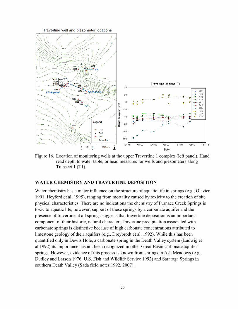
20
Figure 16. Location of monitoring wells at the upper Travertine 1 complex (left panel). Hand
read depth to water table, or head measures for wells and piezometers along Transect 1 (T1).
WATER CHEMISTRY AND TRAVERTINE DEPOSITION
Water chemistry has a major influence on the structure of aquatic life in springs (e.g., Glazier 1991, Heyford et al. 1995), ranging from mortality caused by toxicity to the creation of site physical characteristics. There are no indications the chemistry of Furnace Creek Springs is toxic to aquatic life, however, support of these springs by a carbonate aquifer and the presence of travertine at all springs suggests that travertine deposition is an important component of their historic, natural character. Travertine precipitation associated with carbonate springs is distinctive because of high carbonate concentrations attributed to limestone geology of their aquifers (e.g., Dreybrodt et al. 1992). While this has been quantified only in Devils Hole, a carbonate spring in the Death Valley system (Ludwig et al.1992) its importance has not been recognized in other Great Basin carbonate aquifer springs. However, evidence of this process is known from springs in Ash Meadows (e.g., Dudley and Larson 1976, U.S. Fish and Wildlife Service 1992) and Saratoga Springs in southern Death Valley (Sada field notes 1992, 2007).

21
The apparent relationship between changes in BMI community structure and occurrence of armored travertine in the Travertine Spring No. 1 springbrook indicated that additional knowledge of travertine deposition was warranted. Following methods of Dreybrodt et al. (1992), insight into deposition was determined by laboratory analysis of Ca2+, Na+, K+, HCO3
-, Cl-, Mg2+ and SO42 concentrations, as well as EC, and pH in water samples collected
at 10 m, 20 m, 30 m, 40 m, 60 m, 80 m, 100 m, and 200 m from the spring source during March 2009. HOBO® data loggers were also installed at each of these locations to continuously measure water temperature. Water chemistry data were used to calculate mineral solubility for calcite and aqueous CO2 concentration using PHREEQ, an aqueous geochemical modeling program. Water chemistry changes rapidly along the gradient from the source to downstream reaches. During March, water temperature decreased from 34.5oC to 28oC and pH increased from 7.4 to 8.4 in the upper 200 meters of springbrook (Figure 17). The amount of CO2 degassing from water changed with temperature and pH changes, and most of it had degassed at 200 m from the source (Figure 18). PHREEQ calculations indicated that conditions for travertine deposition began approximately 60 m from the source and most of it had been released from water approximately 200 m from the source.
Figure 17. Temperature and pH recorded from the source to 200 m downstream in Travertine No. 1 Spring during March 2009.

22
Figure 18. The amount of CO2 degassed along the upper 200 m (relative to the total amount degassed in this reach, not relative to the total amount available for degassing from the spring water) Travertine Spring No. l during March 2009.
SPRING DISCHARGE
The ecology of spring-fed aquatic and riparian systems is highly influenced by spring discharge. McCabe (1998) suggested that larger springs (those with higher discharge) had greater aquatic habitat heterogeneity and species richness than small springs. This can be attributed to greater microhabitat diversity for BMIs in larger springsbrooks where there is a variety of substrates (e.g., fines, gravel, cobble, etc.), backwaters, pools, and riffles, and current velocities than in springs with less discharge and lower habitat diversity. Fleishmann et al. (2006) also observed that species richness in riparian ecosystems was greater at large springs than at small springs in southern Nevada. This is likely attributed to wider riparian habitat (from the presence of more water) and a wider gradient of soil moisture at large springs than at small springs. Studies have not quantitatively or experimentally examined these relationships, but it is likely that they can be explained in the context of Island Biogeography and species richness/area relationships (MacArthur and Wilson 1967).
These relationships are well accepted with caveats that consider landscape scale, taxonomic and life history, and equilibrium/disequilibrium assessments (e.g., Tews et al. 2004, Kerr and Packer 1997), but there little quantitative information indicating these caveats are applicable to springs. Although it is clear that aquatic and riparian habitats disappear when a spring dries either naturally or by human activities, studies have not assessed the influence of incremental change in discharge on habitats characteristics and species richness in springs.

23
Understanding these relationships is important for the Furnace Creek Springs restoration because it provides perspective to assess achievement of restoration goals in context of expectations for springs of different sizes, and to assess the potential influence of decreasing discharge that may be attributed to recently initiated groundwater pumping near Texas and Travertine springs.
Examining change in environmental heterogeneity also provides an opportunity to assess the magnitude of influence that decreasing discharge may have on the aquatic ecosystem. Ecosystems are influenced by a number of biological and physicochemical factors. Effects on an ecosystem are typically influenced by their magnitude, frequency, and duration of stressing factors. Ecosystems may be resilient (hence returning to their pre-change condition) to stress when stresses are minor, but large stresses may cause ecosystems to change state (Elmqvist et al. 2003). The point at which a stress is sufficient to cause ecosystems change is referred to as an ‘ecological threshold,’ or the point where a relatively small environmental change causes a rapid change in ecosystem state. Generally, these are identified as a non-linear response to stress (Huggett 2005).
Insight into the influence of incremental discharge changes on the Travertine Spring No. 1 aquatic ecosystem is provided by March 2008 field experiments conducted by D. Sada and M. Stone. In these experiments, discharge was continuously recorded (every 5 minutes) with a Campbell data logger and aquatic habitat in the springbrook was quantified at full discharge (mean = 334.6 L/min, range 334.4 L/min to 336.5 L/min (mean = [88.4 gallons/minute, gpm, range = 88.7 gpm to 88.9 gpm] over the February to May period of record) by reductions of 10 percent, 20 percent, 40 percent, and 60 percent of total discharge. At each discharge rate, wetted width (WW) was measured along 36 transects that were oriented perpendicular to the thalweg, and water depth (WD), mean water column velocity (WV), substrate size, and the depth of vegetation or debris (dead vegetation) were measured at five equally spaced points across each transect. Transects were limited to the upper 100 m of springbrook; accessing reaches of the springbrook below this were prevented by dense riparian vegetation. These studies occurred during March, and they minimally influenced the aquatic system by temporally spacing treatments and reducing discharge for short periods of time. Discharge was at reduced at 3:00 a.m., physical habitat measurements were made quickly after sunrise, and full discharge was returned to the springbrook by 10:00 a.m. each morning. Each subsequent treatment was conducted no sooner than seven days following the proceeding treatment. While these treatments stressed the aquatic system, stress was believed minimal because of the short treatment time, the length of time between treatments, and treatments were conducted during cool weather. Additionally, benthic macroinvertebrate collections made following treatments indicated there was little difference in community structure observed by Sada and Herbst (2006).
Changes in aquatic habitat heterogeneity attributed to diversion were assessed through examining WW, WD, and CV measurements (Figures 19 through 21). Means and variances

24
for each parameter decreased over the series of treatments. Decreases in WW were not statistically significant (p > 0.30, one-way ANOVA, df = 4, 178), but differences were statistically significant for WD and WV (p = 0.000, one-way ANOVA, df = 4, 915). Data were tested for normality using the Kruskal-Wallis Test; data were not significantly different from normal.
Figure 19. Mean (+1 se, blue line) and variance (red line) of Travertine Spring No. 1
springbrook wetted width at five discharge rates measured during March 2008 field experiments (N = 35).
Figure 20. Mean (+1 se, blue line) and variance (red line) of Travertine Spring No. 1
springbrook water depth at five discharge rates measured during March 2008 field experiments (N = 175).
0
700
1400
100 90 80 60 40
Percent of Total Discharge
Varia
nce
0
20
40
60
80
CM
0
7
14
100 90 80 60 40
Percent of Total Discharge
Varia
nce
0
2
4
6
8
CM

25
Figure 21. Mean (+ 1 se, blue line) and variance (red line) of Travertine Spring No. 1 springbrook mean water column velocity at five discharge rates measured during March 2008 field experiments (N = 175).
Trends in changing habitat heterogeneity in response to incrementally decreased discharge are exhibited in the slope of change in the variance for each parameter. Figures 19 through 21 show that variance decreases with discharge and that the rates of change are not equivalent for each level of incremental decrease. The rate of change (as shown by the greatest slope relative to a change in discharge rate) that occurred with lowest changes in discharge was less than 10 percent for WW, and less than 20 percent for WD and WV. This indicates that the greatest decreases in habitat heterogeneity attributed to decreasing discharge in Travertine Spring No. 1 occurred with decreases less than 20 percent of total discharge. This is equivalent to declines of approximately 66.9 L/min (17.9 gpm) or discharge rates less than 268 L/min (70 gpm).
Summary The structure of aquatic and riparian communities is affected by many biological (e.g., competition, predation, grazing) and environmental (physical and chemical) factors. Additionally, there are important biological and environmental interactions, each ecosystem is unique, and understanding these interactions is critical to implementing successful restoration programs. Most Furnace Creek Springs have been disturbed to provide water for domestic, municipal, and irrigation uses. Nevares and Texas Springs appear to have been historically similar, each with water discharging from a mound. The Travertine Springs differ by the absence of travertine mound(s) and springs discharge from discrete points and flow down the fall line. Most spring sources have been altered for human use, which is evident by
0
80
160
100 90 80 60 40
Percent of Total Discharge
Varia
nce
0
4
8
12
16
CM
/Sec
ond

26
the presence of excavated channels, tunnels, pipes spring boxes, and surface flow reductions. Research examining riparian and aquatic systems at Furnace Creek Springs indicates that riparian communities are most influenced by water table depth, sheet flow processes, and surface or near surface water availability. Groundwater provides water to aquatic and riparian communities by providing shallow water that can be accessed by plant roots, and by surface discharge that supports springbrooks, some of which are armored with travertine. The major riparian communities shown in the cluster analysis (Figure 12) are controlled by water availability. The Furnace Creek Springs aquatic communities include five endemic species and many species that occur throughout the western U.S. They are primarily structured by water depth, current velocity, and substrate composition. Cascading effects of changing water chemistry from the source to downstream reaches affects riparian and aquatic systems through travertine deposition. This is demonstrated by the influence of travertine on BMI communities and on soil moisture available to riparian vegetation. Experimental manipulation of spring discharge illustrated that habitat heterogeneity in the aquatic system is most affected by decreases that are less than 20 percent of the total, unaltered discharge rate.
SPRING RESTORATION
The restoration of Furnace Creek Springs is challenged by several factors: 1 – spring restoration is a new science and few desert spring restoration efforts have been successful, 2 – the similarity among springs are often small, and unique and distinctive methods are often required to address restoration goals for each site, 3 – there is little historical information describing the physical, chemical, and biological characteristics of most Death Valley springs, 4 – historic activities may have dramatically changed characteristics of many springs beyond our ability to easily restore spring sources and springbrooks to ‘natural conditions’, and 5 – methods have not been developed to guide restoration through a myriad of potentially unknown biological and environmental consequences caused by redirecting springbrook pathways, returning water to spring sources, rewatering springbrooks, and minimizing the effects of non-native plants and animals on restoration success.
Activities necessary to restore the Furnace Creek Springs differs between springs because each is unique historically, and each has been altered by different human activities. Restoration is summarized below by defining goals, delineating guidelines to guide monitoring aquatic and riparian systems and determine their response to restoration, and assessing restoration for each spring in context of the amount of alteration that is necessary to ameliorate effects of past human disturbances.
Different approaches and levels of restoration are described below as ‘No Action,’ ‘Moderate Alteration,’ and ‘Major Alteration’ alternatives. Restoration activities for each site may vary in response engineering feasibility, monitoring information, and practical solutions to resolve challenges that arise during project implementation. Regardless of methods, progress toward achieving goals will require adaptive management that incorporates biological and

27
physicochemical monitoring into the continual assessment of program efficacy and management direction.
Restoration Goals Reestablishing natural processes to achieve abiotic and biotic conditions that represent healthy ecological systems is the goal of the Furnace Creek Springs restoration program. This will be accomplished by reestablishing physical characteristics of spring landforms, hydrologic regimes, and aquatic and riparian ecosystems to historical conditions as indicated from studies examining soil moisture/riparian vegetation interactions and BMI community/aquatic habitat interactions at minimally disturbed (or near reference) Furnace Creek Springs. Discharge will be returned to the surface for several springs, and springbrooks will flow toward their historic terminus using methods that prevent excessive erosion.
Restoration Guidelines The Furnace Creek Springs complex has been disturbed by human activity for more than 100 years, but elements of natural character remain at each spring province. The paucity of historical information describing physical and biological characteristics prevents a precise description of restoration goals. However, studies that quantify characteristics of Furnace Creek Springs environments, and riparian and BMI communities at springs that have naturalized from past disturbance (e.g., Travertine Spring No. 1 and its tributaries, and Nevares Springs) delineate quantitative biotic and abioitic indicators that describe healthy ecological systems. For the aquatic systems, the restoration goal is to reestablish aquatic environments, habitats, and BMI communities, and the spatial variability quantified by Sada and Herbst (2006) in Nevares Springs, and each Travertine Spring, respectively. Restored (from effects of fire and rewatering springbrooks) BMI communities should include all endemic species known from previous studies (taxonomic collections and Sada and Herbst), and for Travertine No. 2 they should not differ from the spring time Travertine No. 1 community described by Sada and Herbst (2006), and in Travertine Nos. 3 and 4 they should not differ from communities in the upper 100 m of springbrook documented in Travertine No. 1 by Sada and Herbst (2006). Differences between baseline and restored communities should not be less than Kendall’s tau = 0.75. The proximity of Travertine and Texas Spring suggests that characteristics of BMI communities at these springs were historically similar. Restoration of Texas Spring will be accomplished when BMI communities, and their spatial variability, are similar to communities in Travertine No. 1 documented by Sada and Herbst (2006), but the number of endemic species in each spring may differ (e.g., Hyalella muerta has not been collected from Nevares Springs).
The riparian restoration goal is to reestablish environmental (e.g., soil moisture, spring discharge, etc.) conditions and communities of native species that are believed to represent historical, natural conditions that were quantified by D. Cooper and colleagues from 2007 to 2010. While spring boxes and excavated channels have captured most of the spring water,

28
natural ground water continues to flow through each spring province. The water table is often deep and supports only the drier phreatophyte communities that are dominated by Distichlis, Pluchea, Sporobolus, and Prosopis. At Travertine and Texas springs, herbaceous riparian communities that are at Nevares Springs occur only within and adjacent to springbrook channels. Elimination of palms and the return of water to spring and springbrook systems should allow more natural conditions to establish.
Salient management elements that are common to achieve and track progress toward restoration in context of each restoration alternative are described below and more specific guidance is presented in the Adaptive Management to Achieve and Assess Restoration Success section.
Achieving a balance between surface flow in springbrooks, and ground water recharge to support phreatophytes is a key riparian restoration element. Vegetation restoration should be an iterative process. The first step should allow vegetation to reestablish naturally and monitor the changes over time. However, many species may not easily or rapidly establish on the newly wetted sites, and potential invasion by cattail, tamarisk or palm is a major challenge to restoration. Planting may be necessary to establish species like honey and screwbean mesquite, and spring obligates such as Fibristylis thermalis, Schoenus nigricans and Scirpus americanus. If planting is necessary, seed should be collected from local plants, within the Travertine complex, and grown by a commercial nursery.
Groundwater monitoring programs should be continued and the discharge of several springs should be monitored at several sites. The amount of water released onto the surface from springs will increase for some springs (e.g., Travertine Springs Nos. 2, 3, and 4), and it may decrease at others due to the effects of upgradient groundwater pumping. To restore and maintain their ecological integrity, discharge from each spring should not decrease more than 20 percent of its total, natural discharge as recorded in 2002 (511 lpm [135 gpm], prior to the initiation of pumping that is now near Travertine and Texas springs). This is based on field experiments conducted in Travertine Spring No. 1 indicating that decreases in discharge greater than this are likely to greatly influence habitat heterogeneity and the BMI community.
Aquatic and riparian monitoring programs should be initiated to document changes associated with restoration. These programs should include qualitative (photography) and quantitative elements that focus on physical and biological metrics (groundwater monitoring wells and piezometers, sample quadrats, line transects, BMI samples, etc.). Guidelines for monitoring Mojave Network springs are presented in Sada and Pohlmann (2007). The aquatic system could be sampled following methods used by Sada and Herbst (2006) during their winter sampling. Vegetation and groundwater sampling could follow the model used by other NPS Inventory and Monitoring Networks for high elevation springs, such as Rocky Mountain or Sierra Nevada Networks. These programs
29
were developed by D. Cooper and his students working directly with National Park and Inventory and Monitoring Program staff, and can be found at: http://science.nature.nps.gov/im/units/romn/monitor/wetland/wetland_Internet_2010.cfm and http://science.nature.nps.gov/im/units/sien/monitoring/Wetlands/WetlandWaterDynamics.cfm
Invasive vegetation should be eliminated to prevent it from dominating native vegetation. This is particularly important at Travertine Springs where there may be a large soil seed bank of Washingtonia filifera and Phoenix dactylifera, and control programs should focus on young plants that can be easily removed or killed before plants are able to flower and produce seeds. Hand removal of individual plants is desirable near springbrooks, however they quickly root into and become attached to the brook travertine deposits. The most intense colonization by exotic palms is likely to be in areas burned and rewatered at Travertine Springs. Intensive control programs should continue until the seed bank of invasive species is depleted and native vegetation dominates the riparian system. The intensity of removal programs may decrease as occurrence of invasive species decreases. Herbicides may be used as control agents where exposure to water can be prevented.
The restoration of Travertine and Texas Springs requires two, step-wise phases. Phase I focuses on restoring springbrooks and minimizing erosion, and Phase II addresses restoring spring sources to naturally functioning characteristics.
Erosion control is necessary for successful restoration. Erosion may be minimized when water is released into ‘new’ springbrooks by beginning with release of small quantities then incrementally increasing releases over a long period of time (maybe up to 2 years). This will allow the natural processes of travertine deposition to armor the springbrooks and minimize erosion potential.
Restoration has been attempted at only a few arid land springs, and no articles have been published describing a restoration program. Several programs near Death Valley have weakly achieved recovery, but additional time is needed for the effects of habitat alteration to stabilize so their efficacy can be assessed. There are sites with minimal success, such as springs at Moapa, upper Amargosa River, and White River Valley (Sada field notes). Major issues influencing the lack of success can be attributed to using inappropriate design methods. Practitioners have guided aquatic restoration using hydrodynamic models to design springbrooks and aquatic habitat. These models were developed for rivers and streams and they focus on relationships between channel morphology and discharge, including consideration of highly variable hydrographs. These models are inappropriate for most springs (they may be appropriate for springs in arroyos and gullies that are scoured by floods, or portions of a springbrook, such as Nevares Springs, where the springbrook enters a gully and is subjected to flooding) because they are designed to assess dynamic lotic environments, not stable systems that

30
are characteristically unaffected by strong hydraulic processes. Lotic system environments are characteristically variable and spring systems are characteristically stable (McCabe 1998). Spring systems, such as the Furnace Creek Springs, are stable environments that are unaffected by seasonal, annual, and daily variability in discharge that characterize lotic systems and strongly influence their channel morphology and BMI communities. The environmental stability of Furnace Creek Springs is confirmed by the presence of crenobiontic species, which do not occupy and cannot survive in, variable environments influenced by either floods or drying. It appears that hydrodynamic models fail to assist with spring restoration because they are weakly able to guide creation of habitat diversity required by crenobiontic species. Additionally, their use has facilitated construction of non-native aquatic species habitats, to the detriment of native species. The Furnace Creek Springs restoration program is unique to other restoration programs in the region because it is guided by identifying biotic and abiotic indicators of natural processes and ecological integrity.
HYDROLOGIC RESTORATION
Recommendations and Practical Considerations Objectives: Simply stated, historic diversions from Travertine and Texas springs have changed spring discharge from natural upslope discharge points to downslope discharge points. The hydrologic objectives of Death Valley National Park involve returning flow to upslope discharge areas, thereby lengthening springbrook courses and increasing riparian area. Restoration needs to be carried out in a manner that does not create unnatural erosion or diminish the capacity of the Furnace Creek collection gallery to meet the non-potable water needs of Xanterra (Xanterra Parks & Resorts, Inc. owns the Furnace Creek Ranch and Inn, and the water rights for their operation. Death Valley NP has a contract with Xanterra to supply them water). To accomplish this, restoration should be implemented incrementally and reversibly, and the hydrologic and biologic responses should be carefully monitored. Another restoration goal is to remove the collection systems. When desired outcomes are achieved, some of the infrastructure (e.g., spring boxes) may be removed. However, the collection pipes which allow us to control releases and return flow to natural discharge areas should be retained, because any benefits from the removal of the collection pipes will be outweighed by the disturbance associated with their removal.
Limitations and Assumptions: One of the greatest challenges in determining the correct course for restoration is our lack of knowledge of past conditions. Research has yielded scant historic photos or descriptions of conditions. The recommendations that follow are based on one simple assumption: areas of naturally high spring discharge water were targeted for development. Therefore, returning flow back to the targeted collection areas is a return to more natural discharge points.

31
The following are recommendations of how to return discharge to more natural discharge points. This will be a stepwise process, and the measures described below are in their recommended order.
Travertine Springs Travertine No. 1
Background: Travertine No. 1 flows southeast from a concrete spring box into a springbrook that is not the natural course from the spring source. Three other springs are tributary to its springbrook along this course. Location of the Travertine No. 1 diversion gallery suggests that the spring naturally flowed west from its source, and did not connect with the three nearby tributary springs. The Travertine No. 1 collection area is approximately 450 m (1,500 ft) upgradient from State Highway 190 and the Furnace Creek Wash. Discharge from Travertine No. 1 has declined from 511 lpm (135 gpm) in 2002, to 340 lpm (90 gpm) in 2008 and 2009, to 227 lpm (60 gpm) in 2010. This decline may be due to the upgradient pumping of groundwater, and/or collection system becoming clogged with roots when the collection area was no longer kept free of deep-rooting vegetation (starting in 2005?). All springbrooks in the province support the most robust populations of endemic BMIs, with the largest amount of habitat in the Travertine No. 1 springbrook.
Recommendations: Restoring Travertine No. 1 to the course of its historic channel should be considered after endemic BMI populations have established in the Travertine No. 2 springbrook. Returning flow to the historic springbrook course can be accomplished by reducing flow into the spring box by constricting the inlet pipe, which will force water back to a more natural discharge point at the collection area. The six-inch inlet pipe can be fitted with a valve, packer, or a diameter reducer, which will force water back into the collection area. It is recommended that this be implemented incrementally and reversibly, starting with a reduction of flow of 75 lpm (20 gpm) to the spring box. This should result in some return of surface discharge to the collection area. Monitoring should be conducted for at least one year before any further adjustments to the discharge into the ‘new’ system are made. This should continue stepwise until all water to the spring box is blocked. Permanent plugging of the pipe and removal of the spring box may be considered when the area stabilizes and is no longer susceptible to erosion. Any benefits from the removal of the collection pipe will be outweighed by the disturbance associated with its removal. Therefore removal of the pipe is not recommended.
Furnace Creek Wash Ditch
Background: Surface flow from flowing and diverted Travertine Springs is captured in a concrete ditch that flows parallel to Furnace Creek Wash. Water crosses Hwy. 190 via a culvert and it is conveyed along the highway in a concrete ditch for approximately 110 m before emptying into the wash. There is no surface flow in the wash along the length of the ditch. The ditch also currently conveys 340 lpm (90 gpm) from Travertine Nos. 3 & 4 collection galleries (piped under the highway). Discharge entering Furnace Creek Wash from

32
Travertine Nos. 3 & 4 may increase to more than 1,000 lpm (270 gpm) following restoration. The ditch is a historic structure, and there must be consultation with the California State Historic Preservation Officer (SHPO) before the structure can be altered.
Recommendations: After receiving approval from the SHPO and Death Valley NP Cultural Resources Branch, drill carefully-placed holes to drain the ditch and restore approximately 110 m (360 ft) of springbrook.
Travertine No. 2
Background: The Travertine No. 2 collection area is approximately 450 m (1,500 ft) upgradient from Hwy. 190. Travertine No. 2 currently flows into a spring box, from which it is piped to join Travertine Nos. 3 and 4 in a flume box. This combined discharge is piped underneath Hwy. 190 where it exfiltrates subsurface in the Furnace Creek Wash. Some of this water surfaces in the wash, and some is recaptured downstream in a collection gallery which supplies Xanterra with non-potable water. Travertine No. 2 discharge was measured at 1,439 lpm (380 gpm) in 2002, and could have declined as much as 265 lpm (70 gpm) since then because of upgradient pumping and lack of maintenance of the collection area. Travertine No. 2 has the greatest potential for restoration because of its high discharge and distance from Hwy. 190. Restoring surface flow to a natural discharge point could restore approximately 450 m (1,500 ft) of springbrook down to Hwy.190 where it enters the culvert and joins surface flow from other springs in Furnace Creek Wash.
Recommendations: Return water to the surface by constricting the inlet pipes and reducing flow into the spring box. This will force water back to a more natural discharge point in the collection area. There are two 6-inch pipes that discharge into the spring box from the collection area. These pipes can be fitted with valves, packers, or diameter reducers to incrementally reduce the amount of water entering the spring box. Flows into the spring box should be initially reduced by 380 lpm (100 gpm), which should cause the return of some surface discharge to the collection area. Monitoring should begin immediately to ensure that erosion is not occurring and the non-potable needs of Xanterra are still met by the Furnace Creek Wash collection gallery. If after one year complications are not observed, the flow to the spring box should be reduced by another 380 lpm (100 gpm) (ergo the amount of water released to the surface would increase by 380 lpm [100 gpm]). This should continue stepwise until all water is blocked to the spring box. Permanent plugging of the inlet pipe and removal of the spring box may be considered after the area re-stabilizes, and there is no threat of erosion from loss of control of the water. Any benefits from collection pipe removal may be outweighed by the disturbance associated with their removal. Because of the anticipated amount of disturbance, removal of these pipes is not recommended.
Travertine Nos. 3 and 4
Background: Collection areas for Travertine No. 3 and No. 4 are approximately 75 m (250 ft) and 25 m (150 ft), respectively, from Hwy.190 and Furnace Creek Wash. Discharge from

33
these springs is currently combined in a pipe and delivered to a flume box near Hwy. 190 that also collects discharge from Travertine No. 2. The combined discharge is piped underneath Hwy. 190 where it ex-filtrates in Furnace Creek Wash. Some of this water surfaces in the wash, and some is recaptured downstream in a collection gallery that supplies Xanterra with non-potable water. Discharge rates of Travertine Nos. 3 and 4 were measured at 190 lpm (50 gpm) and 950 lpm (250 gpm), respectively, in 2002. A valve has been installed upstream from the flume box, which can divert flow from the flume into a pipe under Highway 190 to the Furnace Creek surface. The valve was closed on August 11, 2011 and all water from Travertine Nos. 3 and 4 (approximately 1,000 lpm [270 gpm]) were diverted as surface water into Furnace Creek Wash. After two weeks Furnace Creek had advanced to the low-water crossing on Hwy. 190, and marked declines in water levels were observed in the Furnace Creek collection gallery. On August 25, 2011 the valve was adjusted to reduce the surface flow to Furnace Creek Wash to 340 lpm (90 gpm).
Recommendations: After restoring Travertine No. 2 to its collection area, adjusting the flow (surface or subsurface) from Travertine Nos. 3 and 4 to into the Furnace Creek Wash can be evaluated. It is possible that the 340 lpm (90 gpm) that currently flows onto the wash will need to be returned to the sub-surface where it can recharge the non-potable collection gallery.
Texas Spring Background: Texas Springs was highly altered to collect tunneling into a hillslope and eliminating surface discharge. Travertine deposition indicates that mineralization may have created a spring mound, similar to what is at Nevares Springs. There are no historic documents or photographs to more accurately determine historic characteristics of these springs and their springbrooks. Topographic maps and relic mesquite suggest that two springs towards the rear, and on either side of the mound were intercepted and drained. All of the springs’ discharge is now collected in a pipe, and it averages about 680 lpm (180 gpm). Aerial photos and topographic maps suggest that the discharge from the intercepted springs flowed southwest, and then turned northwest towards Texas Springs Campground. Currently the majority of the discharge does not curve to the northwest, but flows westward in a deeply incised ravine that was eroded during uncontrolled releases from the collection system. A road and a power line are alongside much of the incised course. A 2-inch pipe is installed in the springbrook above the ravine, which directs some flow below the road into the natural course towards Texas Springs Campground. If all of the flow was restored to the natural course, it will likely be problematic for campground maintenance. These conditions complicate restoration efforts, and the most appropriate approach to restoration will be one that addresses separate restoration components. The following are the components and their recommended order of implementation.
1) Aggradation of the Unnaturally Incised Ravine: Mitigate the effects of the unnaturally incised ravine which has resulted in an increased localized stream

34
gradient and decreased availability of water to plants and animals. Aggradation of the channel can be promoted by placing gully-plugs, rocks, or woody material in the flow, which will widen the channel, and dissipate energy and trap sediment during storm runoff. Most of the material for channel aggradation will come from the banks as the channel widens. The desired outcome will be a widened riparian zone, and increased availability of water and cover for wildlife. Channel aggradation and widening can be carried out in the upper reach without disturbing the road or power lines. In the lower reach this approach will require moving the utility lines and closing the road, because the channel will consume their paths as it widens. Closure of the road has already been discussed, but relocating the utility lines will be problematic.
2) Increase the Amount of Flow Directed to Texas Springs Campground: Increase the diameter of the pipe (by 1 inch) that directs flow under the road toward Texas Springs Campground. Install a valve on the pipe so that the flow can be reduced if it creates erosion or maintenance problems. Monitor the effects along the springbrooks and at the campground for one year. If the outcome is positive, increasing the flow towards the campground should be considered. This can be accomplished by installing another, or a larger pipe.
3) Note: If components 1 and 2 are both implemented, component 1 should be accomplished first, because larger quantities of water will more effectively widen the channel and increase aggradation.
4) Decommission the Flume Box: Before control of flow from the flume box is relinquished, the immediate down-slope area must be stabilized. The outlet from the flume box will be valved back to a point where water barely overflows the flume box walls. The area will be allowed to stabilize with vegetation and mineralization for one year before considering increasing the flow. Overflow from the springbox will be increased through incremental valved reductions in flow from the outlet, followed by one year of monitoring. Removal of the flume box will be considered when the area has sufficiently stabilized to a point where erosion is no longer a concern. Any benefits from the removal of the outlet pipe will be outweighed by the disturbance associated with its removal. Therefore, removal of the pipe is not recommended.
5) Decommission the Tunnel: When downstream conditions are stabilized, decommissioning the tunnel can be considered. Decommissioning the tunnel will involve creating a bulkhead at the tunnel entrance, and filling in the tunnel behind it. The fill material will be introduced through the access ports on the top of the hill above the tunnel. The fill should be locally derived, and it must be free of non-native plant seeds. Ideally, the fill will have the same hydraulic properties as the material that was excavated. The hill appears to be Furnace Creek Formation, which is primarily clay. There are also sandstone interbeds which appear to have transmitted

35
springflow, resulting in travertine deposits. The tunnel may have intercepted the fanglomerate (sands and gravels) of the Funeral Formation at the rear of the tunnel. Steeply-dipping and deformed contacts add to the anisotropy (differing permeability in different directions). It is highly improbable that the hydraulic properties of the excavated materials could be recreated. Furthermore, it would be difficult to fill the tunnel with the primarily fine-grained material that was excavated, because it would immediately be washed out in the springflow. The fill must be started with a gravel base in the bottom third of the tunnel that will not wash out with the springflow. This is expected to create some flow from the tunnel entranceway and slope face, and one year should be allowed for vegetation and mineralization to stabilize the area. The middle third of the tunnel will be sand, and again, any new discharge areas will be allowed a year to stabilize. The uppermost tunnel-fill will be clay. Spring discharge will be monitored during all filling. Excessive fill material in the springflow will indicate that the fill material is too fine and a coarser layer is needed. Removal of the tunnel walls and entranceway would result in unacceptable erosion potential, and therefore is not currently being considered by Death Valley National Park management. The structure also has historic value.
Restoration Alternatives Three restoration alternatives, No Action, Minimal Alteration, and Major Alteration are described below for Travertine and Texas Springs. Nevares Springs are in good condition and require little restoration. While a restoration of this spring is unnecessary, monitoring should be conducted to insure that existing vegetation and BMI communities, and surface discharge rates do not change. If the spring box in Nevares is abandoned in favor of pumping from a well, spring discharge, and the extent and species composition of riparian and aquatic communities should be monitored, and pre-pumping conditions should be maintained.
The amount of management, habitat manipulation, and cost of implementation is lowest for the No Action and greatest for the Major Alteration alternative. Maximizing restoration potential for each alternative requires accumulating information through qualitative and quantitative monitoring of springbrook channels and aquatic and riparian communities to track changes initiated by restoration actions and to change management direction if the approach is ineffective or if the desired goals are not being met. These alternatives represent three possible approaches to restoration, and each alternative can restore natural functioning characteristics of the aquatic and riparian systems. If erosion is controlled, there should be little difference in the amount of aquatic and riparian habitat restored from each alternative, but the results from each alternative will differ in the time to achieve restoration, and in how and where water will reach the land surface. Alternatives also differ in the extent that they restore spring systems to historic conditions. The No Action and Minimal Alternation alternatives will restore springs to conditions that resemble, but probably do not mimic, historic and natural characteristics, and the Major Disturbance alternative returns systems to

36
conditions that are believed to represent the springs as they were structured prior to human alteration. The Minimal Disturbance alternative will achieve conditions that are between these alternatives. Although management may identify a single alternative as the most feasible and cost effective when restoration begins, information accumulated as restoration proceeds may indicate that the program can be more effective if it includes elements of other alternatives. Therefore, each alternative should not be considered as a singular, absolute restoration program, and the restoration program should change and adapt to most effectively achieve restoration.
TRAVERTINE SPRINGS
The Travertine Spring complex was first developed by Robertson and Coleman in 1882. It includes 10 springs, or points of ground water discharge, that are scattered over more than 35 hectares. The size of this area, number of altered springs, and the myriad of factors that have altered its natural character suggest that restoration will require more time and greater resources than restoration of other Furnace Creek Springs. Evidence of human disturbance includes drying of the Travertine Springs Nos. 2, 3, and 4, capture of Travertine Springs No. 1 into a spring box and diversion of its springbrook into a ‘new’ and existing channel, the presence of scattered pieces of old, rusty pipe, and excavation of channels that lowered the surface level of most spring sources and springbrooks by more than two meters. Exotic palm trees dominated the riparian vegetation at these springs until early 2011 when they were mechanically removed following an autumn 2010 fire. It appears that the alteration of lower springs and springbrooks in the Travertine No. 1 has been less than at other Travertine Springs. The benthic communities in these springbrooks are similar to the community in Travertine Spring No. 1, which indicates that this springbrook has naturalized from past disturbance. All discharge from Travertine Springs Nos. 2, 3, and 4 is currently captured in pipes and no water currently discharges onto the surface. Without historic records, it is not possible to accurately locate where springs historically discharged to the surface. Since collection galleries are typically placed at or near sites where water naturally discharges (hence spring sources), it is reasonable to assume that some or all of the Travertine Springs historically discharged near the existing galleries.
Restoring riparian vegetation at this spring province requires reestablishing and maintaining a ground water table sufficiently close to the soil surface to support phreatophytes such as mesquite species, Pluchea and other species, as well as herbaceous plant communities within and along springbrooks. In addition, a goal should be to prevent the establishment of non-native invasive species, particularly palms and tamarisk. Restoring the aquatic communities requires returning surface discharge for springs Travertine Nos. 2, 3, and 4, removing the Travertine Spring No. 1 spring box and returning its springbrook to its historic course, and establishing BMI communities that characterize the Furnace Creek Springs.
It is not possible to determine how water availability to vegetation will respond to removing or leaving collection galleries in place, and the precise location of historic springs is

37
unknown. Since collection galleries do not drawdown groundwater, it is unlikely the water table will change if they are removed or retained. Since the water table in the Travertine Springs area is controlled more by lithology, and potentially ground water pumping, than by the collection systems, retention or removal of collection galleries may have little effect on locations where water will come to the surface.
Travertine Springs – No Action Alternative Restoration Program
There will be little management to accomplish restoration under this alternative. Collection gallery maintenance should be terminated. Spring diversion structures would not be maintained, removed, or modified. Water will return to springbrooks without management intervention. Water may return to the surface through natural processes, and only following deterioration of buried diversion structures. Minimal effort will be made to control invasive species, the discharge from Travertine No. 1 will not be removed from its existing brook.
It will be necessary to modify springbrooks to protect Hwy. 190 from erosion. This may require diverting springbrooks into culverts and man-made channels that control flow and deliver water into Furnace Creek Wash.
Environmental and Biotic Consequences
Restoration will be achieved slowly under this alternative, possibly taking decades for diversion gallery infrastructure to deteriorate before collapsing, and ground water forming a mound near the spring box and discharging to the land surface. It is difficult to discern where water will surface under this alternative, and it may therefore be difficult to return water to historic channels. Water may follow its own pathway. Without active management, erosion control will be difficult. As observed at Texas Spring, excessive erosion creates off-site management challenges and limits restoration potential by preventing riparian vegetation access to water. Data have not been collected to determine the influence of erosion on BMI communities, but erosion is known to adversely affect aquatic communities (e.g., Wood and Armitage 1997). Incision as occurred at Texas Spring, lowers the springbrook water level, which decreases the availability of water for terrestrial animals and riparian vegetation.
Restoration under this alternative may be ineffective because of the length of time required for the collection structures to become dysfunctional. Therefore, management options will be limited and stochastic events will determine the pathway for hydrologic changes.
Travertine Springs – Moderate Alteration Alternative Restoration Program
Under this alternative, active management will control invasive species and release water for Travertine Springs Nos. 2 and 3 into historic springbrooks through existing valves and pipes. Water from Travertine Spring No. 1 is currently collected in a gallery and discharged through a concrete spring box into a channel that is near, but does not include, its historic course.

38
When aquatic and riparian communities have been restored at Travertine Springs Nos. 2 and 3, and the effects of fire on riparian and aquatic systems supported by Travertine Spring No. 1 and its tributaries has been alleviated and the systems are restored, water from Travertine No. 1 should be redirected into its historic channel. This can be accomplished by redirecting discharge from the pipe that discharges water to the east to the pipe discharging to the south (which directs water into the historic channel). This transition should occur slowly by incrementally increasing flow into the historic channel in a manner that minimizes erosion and creates naturally functioning aquatic and riparian ecosystems.
Sub-surface collection galleries will not be removed but allowed to deteriorate with old age. Erosion can be managed under this alternative using existing pipes and valves to incrementally increase surface discharge and allow travertine deposition through natural processes. Travertine will armor springbrook channels and minimize erosion potential.
It will be necessary to modify springbrooks to protect Hwy. 190 from erosion. This may require diverting springbrooks into culverts and man-made channels that control flow and deliver water into Furnace Creek Wash.
Environmental and Biotic Consequences
Returning water to the surface will occur whenever existing valves are manipulated to redirect discharge onto the land surface from pipes and collection galleries. With this control, the quantity of water released can be readily managed to minimize erosion. Incremental releases will also allow water to be easily directed toward natural channels, and for travertine deposition to slowly begin to initiate natural processes affecting BMI and riparian environments. Underground diversion structures will be allowed to deteriorate, which will probably include collapse of structures and intrusion of roots from vegetation becoming established, and the absence of vegetation control that has occurred for decades.
Travertine Springs – Major Alteration Alternative Restoration Program
Restoration under this alternative includes all elements in the Moderate Alteration alternative. It also includes additional actions to return the spring province to its natural state. After springbrook habitats and communities in Travertine Spring Nos. 1 (and its tributaries), 2, 3, and 4 have achieved biological restoration goals, all collection galleries will be mechanically removed or destroyed in place by plugging the infrastructure, and water allowed to freely discharge onto the land surface and into springbrooks. Additionally, springs that have been excavated will be filled with native soil and the surrounding area contoured to match the local, pre-disturbance condition.
It will be necessary to modify springbrooks to protect Hwy. 190 from erosion. This may require diverting springbrooks into culverts and man-made channels that control flow and deliver water into Furnace Creek Wash.

39
Environmental and Biotic Consequences
It is unclear how restoration may be affected by collection gallery removal, or destruction, and we know of no spring restorations that have removed collection galleries. Removal may have only short term influences on restoration and the spring may quickly stabilize to a natural state. Removal may also produce unknown, long-term consequences. Galleries removal should occur only after all springbrooks in the province are carrying all of their discharge, and their aquatic and riparian communities have matured and stabilized. Additionally, removal should be first attempted at the smallest spring (e.g., Travertine No. 1), and the effects of removal monitored for an extended time to assess the spring’s response. Lessons learned from this ‘experiment’ should guide other gallery removals.
Before the recent fire, springs that have been excavated appear to have naturalized from this disturbance since they all supported BMI communities that were similar to other springs in the province (studies have not been conducted to determine status of their BMI communities since the fire). Prior to the recent fire, exotic palms dominated the riparian community at some springs and others supported native vegetation. It is difficult to predict the consequence of filling previously excavated springs with soil and returning natural contour to sites where they historically discharged. Filling degraded channels is a common practice used to restore springs and streams in western U.S. mountains, where restoration is facilitated by adequate water availability, cool temperatures, and the presence of organic soils. These methods have not been attempted at desert springs, and it is unclear how springbrook levels may be raised over dry, porous, soils with low productivity. However, the effect of placing soils of known particle size distribution could be modeled to predict the future water table elevation. These springs may respond positively by emerging near the existing spring sources and creating travertine springbrooks that transmit water downstream. Or, the response may be negative and spring water may percolate through porous soils without reaching the surface. This scenario may benefit some riparian species but it would not benefit aquatic systems. Several excavated springs flow less than 2 lpm and provide less than 2 m2 of aquatic habitat. Field experiments examining the response of springs to burial could be conducted in these small springs and affect a small amount of aquatic habitat and a small portion of the BMI community.
TEXAS SPRING
Texas Spring is located approximately 1.5 km northwest of Travertine Springs at approximately 120 m elevation. It appears that the historical spring discharged from the top of a travertine mound, similar to Nevares Springs. The site currently bears little resemblance to its historic, undisturbed condition, and its discharge flows from a pipe extending from a stone-lined trench and wooden-lined tunnel that were dug into its spring mound to deliver domestic water to Furnace Creek during the early 1900s. The top of the Texas travertine mound is dry and has almost no vegetation. Diversion for domestic use continued until the early 2000s when it was stopped because the water quality standard for coliform bacteria

40
could not be met. When domestic use ceased, all of the spring’s discharge was released from a pipe and onto the soil approximately 30 m downstream from the trench. Following this release, riparian vegetation (primarily mesquite and Pluchea) expanded along 150 m of springbrook below the discharge point. This reach supports a dense, high quality riparian zone that needs little restoration. However, it is unknown if mesquite can reproduce in this environment. Erosion below this zone created an incised channel up to 5 m deep. This incision may migrate upstream and threaten the riparian zone and existing aquatic system if steps are not taken to stop its advance. After water was released, this reach of springbrook was inoculated with BMIs from Travertine Springs No. 1. The dense and thorny riparian vegetation has limited the surveying of BMIs in this habitat and the aquatic community characteristics are unknown. Limited sampling near points where water is released from pipes found springsnails to be abundant in the sampled portions of the springbrook.
Texas Spring restoration opportunities are challenging because of the extent that the spring source was altered by excavation and tunneling. Returning discharge to the top of the travertine mound is problematic due to soil friability (hence highly susceptible to erosion) and difficulties involved with filling the tunnel and trench, and raising the water level approximately 7 m for the spring to discharge on top of the mound.
Texas Spring—No Action Alternative Little management is needed to accomplish restoration under this alternative. Management will follow activities that characterized work at Texas Spring since water was released from domestic use in the early 2000s. Water will continue to be collected from the trench and tunnel, and discharged to the land surface approximately 30 m downstream from the trench. Neither the tunnel or trench will be removed, modified, or actively managed, nor will there be attempts to restore the spring source. Erosion caused by release of water during the early 2000s will continue, and discharge from pipes will slowly decrease as they become filled with roots from riparian vegetation. Upstream migration of erosion below the riparian zone may eliminate this newly established riparian and adversely affect the aquatic system.
Environmental and Biotic Consequences
Restoration will be limited and existing conditions will prevail for an undermined length of time. Without erosion being managed and arrested, existing conditions are threatened by upstream migration of erosion that is currently downstream of the riparian zone. Decades may pass for the diversion gallery infrastructure to deteriorate and for water to no longer discharge from artificial structures. Erosion near the water source is likely and controlling it will require active management and monitoring. Restoration under this alternative may be ineffective because of the length time required for change and management that is required to avoid adverse consequences of releasing water to the surface. In addition, over time the tunnel will likely collapse, burying the construction materials, and creating an unnatural landform of a collapsed mound system.

41
Texas Spring—Moderate Alteration Alternative Restoration Program
Management will actively address erosion issues, and the springbrook and riparian vegetation will be extended downstream into the reach of springbrook that is now deeply entrenched. The tunnel will not be actively managed, removed, or modified, and there will be no active attempt to restore the spring source. In the near future, the water will continue to flow from the tunnel, into the existing pipe, and under the road and utility corridor that currently pass near the trench opening. Over the long term, the tunnel will collapse, the pipe will become plugged with roots and vegetation, and water will begin flowing across the land surface. As the tunnel collapses, it will but it is not possible to determine where water will flow as it leaves the spring source area. Before the tunnel collapses, water will be released onto the land surface and directed toward the downstream riparian area. Erosion from the new springbrook may be minimized by incrementally increasing the quantity of water released from the tunnel onto the surface and allowing travertine to deposit, armor the springbrook, and prevent erosion through natural processes. Incremental increases in water released into the new springbrook should occur over the period of at least one year.
Environmental and Biotic Consequences
Active erosion control in the entrenched springbrook will alleviate threats to the existing riparian zone and springbrook. Erosion that is occurring in this area will be stopped using gully-plugs, rocks, or other suitable material. Extending the springbrook up to the trench will necessitate removing the road that currently passes near the trench, and it may also require realigning or removal of utility lines/poles that follow this road. Decades may pass for the diversion gallery infrastructure to deteriorate and for water to no longer discharge from artificial structures. Incrementally increasing water to form a new reach of springbrook will minimize erosion while increasing aquatic habitat and opportunities for riparian restoration.
Texas Spring—Major Alteration Alternative Restoration Program
This alternative includes all actions described for the Moderate Alteration alternative and additional work to restore the spring source and the springbrook. The springbrook that is currently downstream from the riparian area will be stabilized and naturalized to increase riparian and aquatic habitats. Removing all infrastructures and filling the tunnel with sediment of similar particle size distribution as the mound sediments will have as its goal the restoration of spring discharge to the top of the mound.
Environmental and Biotic Consequences
Implementing this alternative will be costly and require mechanical alteration of the tunnel/spring mound and downstream portions of the springbrook where erosion is currently active. The tunnel will be filled to close its lateral exit from the mound and raise the water level so that the spring can discharge from top of the spring mound. If this is accomplished, it

42
should be possible to restore vegetation that is similar to that at Nevares Springs mound. The actively eroding channel that extends downstream from the recently created riparian zone will be stabilized and the water surface will be raised to match the surrounding landscape. This will considerably increase the length and width of riparian vegetation supported by Texas Spring, and increase the availability of water and cover for wildlife.
NEVARES SPRINGS
Nevares Springs is located approximately 15 km north of Texas Spring. It consists of several small helocrene springs that discharge from the top of a travertine mound, and a small spring discharging from a tunnel excavated into the base of the mound. Nevares Springs have been altered less than all other Furnace Creek Springs and they appear to have ‘naturalized’ following past disturbance events. Discharge from springs atop the mound has been decreased by operation of a springbox that collects and diverts water to the U.S. National Park Service employee housing area at Cow Creek. The site was recently altered during construction of a monitoring well that was drilled for scientific purposes. Evidence of historic use is indicated by presence of old irrigation ditches that directed water to a small historical ranch house and orchard located at the travertine mound base. Visible impacts include the drying of portions of the mound and mound margins where dead mesquite and other wetland and riparian vegetation are apparent. However, relatively little restoration work is needed at Nevares Springs.
The following actions are recommended to maintain and track the ecological integrity of this system:
Remove all non-native species, primarily exotic palms and tamarisk, and maintain native vegetation with periodic monitoring to identify and remove exotics.
Conduct long-term BMI monitoring.
Explore the Nevares springbox with sewer camera, and make sure the plumbing operating properly.
Monitor long term water level changes at the Nevares Springs complex to determine effect of ongoing NPS pumping on aquatic and riparian communities.
ADAPTIVE MANAGEMENT TO ACHIEVE AND ASSESS RESTORATION SUCCESS
Guidelines Monitoring must be conducted to assess the immediate and long-term effects of restoration and inform adaptive management. Adaptive management cannot occur without monitoring. The dependence of spring systems on groundwater requires an integrated assessment of hydrology and riparian and aquatic ecology to track restoration success and inform adaptive

43
management. Recommendations are summarized below for the integrated monitoring of each of these systems.
Adaptive management will be utilized to help the National Park Service make short-term and long-term decisions about actions needed to naturalize or restore Travertine and Texas springs. Management options were developed and presented in this report from on-site scientific research, and DEVA staff experience. Once the initial recommendations are implemented, careful monitoring will provide data that can be used to make future ongoing decisions. Data should be collected on spring discharge, channel incision, ground water levels, aquatic invertebrate populations, plant establishment and cover along channels, and on slopes with shallow depth to groundwater.
Using data collected following the release of water from the springs decision-makers can evaluate results and adjust actions on the basis of what has been learned. The data collected should be used to increase DEVA’s understanding of spring functioning, reduce uncertainties about the decisions that can be made, and develop a model of spring hydrologic regime and biotic responses to the actions. The restoration program should embrace the risks and uncertainties involved in scientific restoration and monitoring as a way of building understanding of the hydrologic and ecological systems being modified.
Several factors should be considered in implementing adaptive management. First monitoring is an ongoing process and will not be complete until the systems are completely restored. This process may take 10 or more years. The monitoring data must be analyzed to evaluate changes to the systems following any actions. A sufficient period of monitoring must occur to adequately monitor changes and so that the changes have time to completely manifest themselves. DEVA must provide sufficient staff and instruments to monitor the chosen hydrologic, geomorphic, and ecological variables.
Monitoring and research are primary elements that provide information to implement successful adaptive management programs. Adaptive management entails two basic types of monitoring: 1 – species status and trend monitoring to document spatial and temporal changes in the abundance and distribution of focus species (ergo rare or indicator species), and 2 – effectiveness monitoring to assess the efficacy of management to accomplish goals. Both types may be required to provide feedback and assess the effectiveness of management, determine changes in the status of rare species, and accomplish restoration goals.
In response to requirements necessary to assess the conservation status of rare species and implement adaptive management programs, resource managers have recently given substantial attention to designing and implementing monitoring programs (e.g., Peterman 1990; Hayek and Buzas 1997; Noon et al. 1999; Noon 2003). Effective monitoring programs rely on explicit description of goals and objectives to focus data collection and compile information about salient variables and avoid accumulating unnecessary or irrelevant information. A reasonable goal of species status monitoring programs is to quantitatively document spatial and temporal variation in the abundance and distribution of a species, and

44
an objective would be to determine if abundance and distribution are static, improving, or declining. Similar goals and objectives can be identified for effectiveness monitoring programs, where a goal might be to assess the efficacy of a management program on ecosystem health and determine if health is improving or degrading. Once goals and objectives have been set, each monitoring program must be tailored to address these elements in context of the ecology of the target species or ecosystems in question.
Effective species status monitoring programs should collect relevant biological and environmental data during each sample. Collecting both data sets increases the utility of data to examine ecological links, which can explain relationships between environmental conditions and the biotic response. Determining these links is not possible when only biotic or environmental data are singularly collected and insight into how biotic metrics change in response to environmental circumstances is limited. Conversely, collecting data that are not tied to the hypotheses or objectives of the monitoring program may be an expensive distraction from the overall monitoring program. It should also be recognized that monitoring, data analysis, alternative action development and selection, and future monitoring does not guarantee that the desired outcome can be achieved. Furnace Creek Springs monitoring should inform aquatic and vegetation restoration needed due to returning water to springbrooks and restoring systems from effects of fire. Monitoring programs described below will address both of these restoration challenges.
The following section describes Furnace Creek Springs hydrology, riparian, BMI, and aquatic habitat monitoring, which includes guidance for the following primary monitoring elements:
1. Stream flow using staff gauges, weirs, flumes or surveyed cross sections. Flow measures should be longitudinal from the spring boxes or other outlets that are down gradient at determined distances. Multiple measurement points would allow the quantification of surface water loss or gain and the efficiency of water movement down the springbrooks.
2. Channel incision can occur when channelized flows remove sediment from the channel bottom and cut deeply into sediments. This should be measured in a longitudinal series of surveyed cross sections. Each cross section should have a permanent monument to allow the same area to be surveyed repeatedly.
3. Water table depth in ground water monitoring wells should be measured to determine the response of the ground water table to the movement of surface water into channels, and the long-term response of ground water levels to the new pumping wells located northeast of the Travertine Springs.
4. Plots should be located in the channels to monitor the aquatic invertebrate composition over time. Specific thresholds for aquatic species presence and/or

45
density could be used to monitor the response of species and the entire community to changes in surface flow.
5. Vegetation on the channel banks and floodplain should match the locations of the surveyed cross sections and/or aquatic invertebrates. This monitoring should document the composition and cover of all plant species. It would be useful to have transects cross the valleys where channel flow will be enhanced to determine whether channel flows enhance vegetation across the area. This is particularly important for Travertine 2, where little riparian vegetation occurs. A future project might involve the collection of mesquite seeds, growth of seedlings in an NPS nursery or contract nursery, and planting of these saplings into desired places in the restored washes.
Monitoring Methods and Strategies Groundwater Hydrology and Spring Discharge, Richard Friese, DEVA
Measurements of Travertine and Texas springs discharge will continue through the implementation of restoration. Discharge of water collected from Travertine and Texas springs will be measured and recorded hourly. The collected discharge though the measuring devices will be reduced as water is returned to natural discharge areas. These reductions of discharge through the collection facilities will represent the amount of water that is being returned to natural discharge areas. Monitoring discharge through the collection systems will continue until there is no longer flow through the systems, or when NPS staff has determined that monitoring these systems is no longer of value.
Piezometers will be installed to measure shallow groundwater levels. The number of piezometers and their locations are yet to be determined. Piezometer installation is limited by widespread travertine deposits that prevent driving the piezometers into the ground. Monitoring water levels will resume at piezometer locations (David Cooper’s) that reacted to groundwater pumping or precipitation events, or demonstrated seasonal or diurnal responses.
Annual mapping of the wetted area perimeter will be conducted using GPS. Springbrooks will also be mapped. Mapping will be conducted during the first week in June, which is the driest average time of the year. Mapping during the driest time of the year will help ensure that any recorded expansion/contraction of wetlands or advance/retreat of springbrooks is an indication of the condition of the springs, and not precipitation.
Soil Moisture and Vegetation Monitoring, David J. Cooper, CSU
Monitoring wells installed in 2007 and 2008 that were damaged by the Travertine Springs fire should be rebuilt for long-term use. The below ground portions of wells were not damaged, but the well casings should be cut, couplers added, and a new above ground section of PVC attached. Water levels in wells could be manually measured on a monthly basis to study the effects of ground water pumping and springbrook restoration on water table depth and vegetation. One circular plot should be established centered on each well to record the presence and percent cover of each vascular plant species present. A 2 m radius plot is

46
recommended. This plot should be analyzed in early summer (April or May) each year to quantify vegetation composition and changes in composition over time. The vegetation of perennially wet sites associated with springbrooks should be dominated by the Eleocharis rostellata – Schoenus nigricans community. Areas with water tables deeper than 0.5 m but less than 1.5 m should be dominated by Pluchea sericea, or where soils are saline by Distichlis spicata. Sites with deeper water tables would include riparian vegetation dominated by mesquite (Prosopis spp.). For long-term mesquite bosque restoration, it may be necessary to collect mesquite seed from intact mesquite stands, and work with a nursery to have saplings grown for planting in areas with suitable water table, but lacking mesquite. Mesquite plantings should occur in early spring, and may require supplemental watering to facilitate survival until the plant roots reach the water table.
Aquatic System Monitoring, Donald W. Sada, DRI
Standardized methods to quantify environmental and biological characteristics of lotic systems are well known (e.g., Barbour et al. 1999), but spring sampling methodologies remain in their infancy. This can be attributed to the small number of studies examining springs, while methods used in lotic systems are based on many years of work. Methods used in large systems are not appropriate for springs because sample gear is often too large for small aquatic systems, and equipment and sampling intensity must be optimized to avoid any long-term effects of sampling disturbance on environments and communities while rigorously collecting data. Sada and Pohlmann (2007) outlined methods to inventory and monitor biotic and abiotic characteristics of NPS Mojave Network springs from their experience in the Great Basin and Mojave deserts, and these methods should be reviewed by personnel conducting field surveys at the Furnace Creek Springs to gain insight into sampling challenges and strategies. Sada and Herbst (2006) used elements of these protocols for their work in Travertine and Nevares springs, and this work provides a quantitative description of the ‘baseline and climax successional’ condition of Furnace Creek Springs BMI communities and aquatic habitats. Because of this information, salient elements of their methods should be used during aquatic monitoring.
Field and laboratory work should be conducted by trained personnel to ensure data are consistently and accurately collected. BMI field work and identification require specific training; most identification requires microscopic examination and knowledge of taxonomy, and quadrat sampling requires care and precision to effectively collect animals. Aquatic habitat sampling requires less training, but all personnel should follow standardized methods to minimize inter-sampling variability attributed to sampling error. Care must be taken to clean all aquatic system sampling equipment to prevent translocating animals between Travertine, Nevares, and Texas springs and other springs that may be sampled in the region (See guidance in Appendix III of Sada and Pohlmann [2007]). Connectivity among Travertine Springs suggests that it is not necessary to clean equipment when sampling is limited to springs in this province.

47
The paucity of information describing how arid land spring biota and aquatic habitats respond to restoration suggests that information compiled during Furnace Creek Springs restoration will significantly contribute to existing knowledge and facilitate restoration success in other regions. Collecting detailed information describing changes in the biotic communities would provide the greatest contribution for work in other areas.
Aquatic monitoring for the Furnace Creek Springs should examine three elements: 1 – aquatic habitat, 2 – endemic species, and 3 – the BMI community. Aquatic habitat and endemic species monitoring are relatively simple and inexpensive, and this provides important information about the springbrook environment and the potential of restored habitats to become healthy systems. Quantifying structure of BMI communities provides a superior measure of ecological health because these assessments provide a broader consideration of environmental integrity and diversity that are indicative of healthy systems. Sampling BMI communities is relatively expensive, and sampling frequent sampling may not be necessary if the presence or absence of the crenobiontic community is regarded as a primary element indicating healthy aquatic systems.
Biotic and abiotic characteristics of these aquatic systems will change as time passes and each system progresses from early toward late successional stages. Monitoring should document both short-term and long-term biotic and abiotic change, and it should also provide information to assess the effects of change attributed to the two primary restoration factors, which are recovering from fire and reestablishing springbrook communities following rewatering. Monitoring should document the early establishment of vagile, early colonizing species in Travertine Springs Nos. 2, 3, and 4 (and Travertine No. 1 after it is redirected into its historic channel), and track the increasing presence of crenobiontic species following their introduction. Documenting change in BMI communities provides information about successional change, but this level of work may not be necessary to track progress toward full restoration. Progress toward restoration will be indicated by the presence of crenobiontic species because they are sensitive and do not occupy degraded or altered habitats. The monitoring described below focuses on determining the presence of these species during early stages of restoration (while sampling the BMI community at a small number of sites). Full assessment of restoration success can only be determined by comparing BMI community composition and structure with ‘baseline’ conditions described by Sada and Herbst (2006). BMI samples collected within 60 days of the Travertine Springs fire show that all crenobiontic species remain in the systems, but that their distribution is patchy and that highly tolerant species dominate the community in many areas (Sada and Rosamond laboratory notes). Annually sampling this community from spring sources to Hwy. 190 would provide insight into successional change following disturbance, and develop predictions into successional changes in BMI communities occupying rewatered habitats. Different BMI sampling strategies are outlined below to most effectively track differences attributed to these two restoration trajectories.

48
Aquatic Habitat Monitoring
Salient environmental characteristics of springbrook channels should be quantified, in addition to GPS mapping that is discussed above. Channel characteristics of long springbrooks (e.g., Travertine Nos. 1 and 2) should be monitored through quantitative and qualitative assessments at four areas along the springbrooks from spring source to Hwy. 190. For these springbrooks, areas should be at the spring source, 100 m downstream, at mid-distance between the source and Hwy. 190, and no less than 50 m upstream from Hwy. 190. Sampling in shorter springbrooks of Travertine Nos. 3 and 4, can be limited to two areas, one near the source and the second area as close to Hwy. 190 or the terminus of water as possible. Tributaries to Travertine No. 1 should be sampled at one area located approximately half the distance from the source to its confluence with another springbrook. Permanent monuments should be installed to identify each area. In each area, measure the wetted width, total number of springbrook channels, and the total distance between the outside banks of channels of the outer-most channels limits of water along 5 transects that span all channels and are oriented perpendicular to the thalweg. Habitat sampling should occur during spring and late summer of the first three years after water is returned to the surface, once during the late summer of the following three years, then bi-annually for the following next three years. Use professional judgment to determine sample schedules after this period. Locate transects at 3 m intervals along the gradient of long springbrooks and at 50 cm intervals of short springbrooks. Minimize the impact of sampling and avoid bias attributed to continuously sampling the same location by placing the first transect 50 cm and 100 cm on alternate years, respect`ively, from the monument. At 5 evenly-spaced points across the wetted width of each transect measure water depth and mean water column velocity, and estimate the percent coverage of emergent and riparian vegetation. At the mid-wetted width point, record substrates by noting the presence of fines, sand, gravel, cobble, and armored travertine within a 10 cm X 12 cm quadrat. Habitat sampling should be initiated within 3 months of when water is first released into the ‘new springbrooks’.
Aquatic system restoration will be achieved when aquatic habitat characteristics and the spatial variability that was observed by Sada and Herbst (2006) in Travertine Spring No. 1 and its tributaries is established. This will also be indicated when conditions allowing natural processes including thermal zonation, travertine deposition, and habitat heterogeneity, which are indicated by the range and variance in water depth, mean water column velocity, wetted width, and substrate observed by Sada and Herbst (2006) are established (Table 1). Diligent water temperature monitoring is unnecessary because thermal characteristics will become naturalized when channel morphology is restored. Evidence of travertine deposition will be documented from data assessing characteristics of the springbrook channel. The change in substrate composition from spring source to Furnace Creek Wash that was recorded by Sada and Herbst (2006) in Travertine No. 1 is an indicator of successful restoration and adaptive management.

49
Table 1. Water depth, mean water column velocity, and channel wetted width range and variance observed in Travertine No. 1 and its tributary springs by Sada and Herbst (2006).
Parameter Range Variance Water Depth 1 cm to 10 cm 95 Water Velocity 0 cm/sec to 39 cm/sec 5.7 Wetted Width 6 cm to 1,200 cm 13,400
Aquatic Habitat Sampling Field Equipment
Metric fiberglass tape measure, 50 m minimum
Plastic ruler with metric measurements
Model 2000 Marsh-McBirney portable current meter with top-setting wading rod
Datasheets and clipboard, or electronic data logger
Pocket calculator to calculate distance between equally spaced transects and points across the wetted width.
BMI Sampling
BMIs should be sampled using equipment (Figure 22) and methods described by Sada and Herbst (2006). They sampled using a small dipnet and a 12 cm wide and 10 cm deep quadrat constructed with ¼-inch diameter brass rod. Neither the quadrat nor the net are available commercially. The net was constructed by sewing 250 µm mesh netting into the frame of a 10 cm X 12 cm aquarium net. Collect BMIs by placing the quadrat on the substrate and gently scrubbing it within confines of the quadrat for no less than 15 seconds to dislodge BMIs and allow them to drift downstream into the net. Elutriate samples in a small bucket to minimize the amount of organic and inorganic material, and collect the elutriated material in a net that is gently dripped to dry. Place the sample in a plastic bottle, cover it with 90 percent EtOH, and add a label showing who collected the sample, the sample date, and sample locality. Seal bottles, return them to the laboratory, and complete a chain of custody form to begin tracking each sample. BMI sampling should begin within six months of the time when water is first released into the ‘new springbrooks’. Coincidentally, quantify environmental characteristics (wetted width, water depth, mean water column velocity, water temperature, electrical conductance, and the presence of fines, gravel, cobble, armored travertine, etc.) within each quadrat (as described in the aquatic habitat monitoring section). Rarefaction curves (e.g., Figure 23) suggest that this gear can be used to accurately quantify the BMI community when an adequate number of samples are collected. Additionally, sampling with this gear minimally affects a small amount of aquatic habitat in these sensitive habitats.

50
Monitoring these aquatic systems requires different methods to collect information that is relevant to restoration and adaptive management of each spring or restoration project. Nevares Springs should be monitored to determine temporal variability in BMI communities and aquatic habitat, and how this variability compares to ‘baseline’ conditions described by Sada and Herbst (2006). Travertine Spring No. 1 and its tributaries should be monitored to assess change in BMI community and aquatic habitat following the 2010 fire and to
A)
B)
Figure 22. A) 10 cm X 20 cm brass quadrat, B) 10 cm X 20 cm brass quadrat with 10 cm X
20 cm, 250 µm mesh dipnet.

51
Figure 23. Rarefaction curves showing the cumulative number of species collected in the Travertine Spring Province and Nevares Springs as reported by Sada and Herbst (2006) for 1998 spring time samples, and during winter 2010 by Sada for this restoration plan. The number of meters of springbrook sampled shown for each curve. Springs as named in Sada in Herbst (2006); they name No. 1 ‘UT’.
determine how BMIs change with this recovery in context of ‘baseline’ information compiled by Sada and Herbst (2006). Monitoring for Travertine Nos. 2, 3, and 4 should initially assess their progress toward becoming health spring environments, then progress toward reaching successional climax, which is indicated by ‘baseline’ conditions described by Sada and Herbst (2006).
Two BMI guilds are important indicators of the ecological health of Furnace Creek Springs. Crenobiontic species comprise a guild of species that occur only in environments supported by the Furnace Creek Springs, they occupy a narrow range of microhabitats, and a group of species that are relatively sensitive to environmental change and variability. All other BMIs are a guild of species that are relatively insensitive to environmental change and variability, and they occur in many arid land aquatic systems in the southwest. Presence of both guilds in each spring is an important indicator of successful restoration and ecological health, and the challenge of BMI monitoring is to implement sampling strategies that provide information about each guild.
Crenobiontic Guild – The presence or absence of the suite of crenobiontic endemic species in a restored spring system may provide a rapid assessment of the aquatic system, and may be the most important indicator of ecological health of springs in this region. This is suggested
0
5
10
15
20
25
30
35
40
1 3 5 7 9 11 13 15 17 19 21 23 25 27 29 31 33
No.1-1998No. 1-2010MT-1998LT-1998Nevares-1998NC-1998
520 m
100 m
290 m 250 m
70 m 190 m
Number of Samples
Num
ber o
f Spe
cies

52
by Sada (2000) who found that the presence of crenobiontic species was an indicator of BMI richness, and the presence of other crenobiontic macroinvertebrates in the region is an indicator of stable, high quality aquatic environments in the Great Basin and Mojave Deserts (see Polhemus and Polhemus 2002; Hershler and Liu 2008). Conversely, their absence from a restored system may indicate that an environment trenchantly differs from prehistorical conditions and that existing conditions do not provide for biological restoration. Additionally, the U.S. Fish and Wildlife Service lists Ambrysus funebris as a candidate species, and their absence may justify listing as threatened or endangered. The presence of the suite of endemic BMIs known from near the source and near the terminus of each Furnace Creek Spring (as observed by Sada and Herbst [2006]), is an indicator that restoration and adaptive management are successful.
Sada and Herbst (2006) found that presence of the suite of crenobiontic species in Travertine and Nevares springs could be determined by collecting from 1 to 5 quadrats in the upstream 30 m of a springbrook (Table 2). The number of samples needed to document presence of each crenobiontic species differed. Ipnobius robustus (a springsnail), Hyallela sandra (a crustacean), and Microcylloepus formicoideus (a beetle) were ‘abundant’ and found in the majority of samples, but Hyallela muerta and Ambrysus funebris (a true bug) were scarce and occurred in few samples. This suggests that the presence of some species can be determined from a few samples, but additional sampling may be required to record the presence of rare species.
Identifying I. robustus and A. funebris with the naked eye is relatively easy for trained personnel, and their presence may be determined by examining live qualitative samples placed in a shallow tray. Following examination, these live samples can be returned to the springbrook. Differentiating the two amphipods, and M. formicoideus from M. similus, requires preservation and microscopic examination in the laboratory.
Insensitive Species Guild—Sada and Herbst (2006) found that a large number of samples taken from spring source to terminus was required to determine richness and structure of the insensitive species guild in Travertine and Nevares springs. This is shown by rarefaction curves compiled from their data that show the cumulative number of species captured relative to the number of samples taken in Travertine Spring No. 1 and its tributaries, and Nevares Springs (Figure 22). These curves show that richness is underestimated when a small number of samples are collected, and asymptotes for springtime sampling of longer springbrooks are generally approximated when more than 20 samples are examined. In these curves, richness is generally correlated with springbrook length, which is not surprising because richness in sample quadrats increased along the gradient from spring source to terminus in Travertine Springs (see Figure 8). Examination of curves from springtime and winter sampling in Travertine No. 1 also suggests that sampling seasonality may be an important factor. Both of these samples documented approximately 15 species in the upper 100 m of springbrook, but this richness was found from 10 springtime samples (1998) and 31

53
Table 2. The total number of 10 cm X 12 cm spring time samples taken by Sada and Herbst (2006), and the number of samples within the upper 30 m of habitat of Travertine and Nevares Springs to capture all endemic species known from each spring during the spring time. The number of samples in each spring that include all endemic species shown in parentese. Spring names and data from Sada and Herbst (2006). Five of the Furnace Creek Springs endemics are known from Travertine Springs, four from Nevares Spring, and three from NC (also referred to as Nevares Cave Spring). * All crenobiontic species in Nevares Spring were not collected until 10 samples had been taken over approximately 110 m of springbrook.
Spring Name Total No. Samples Taken No. Samples Needed to Capture
all Endemic BMIs No. 1 32 5 (2) MT 14 3 (4) F1 2 2(1) F2 3 ND LT 9 1(1) LTA 6 1 Nevares 24 10 NC 7 1
winter (February 2010) samples. These differences may be attributed to higher densities and richness in warmer months compared to winter, which suggests that fewer springtime and summer samples are needed to accurately describe BMI communities than winter samples. Determining richness is important because quantifying species richness and the structure of the BMI community are both indicators of ecological health (see Rosenberg and Resh (1993). Documenting how richness community structure change and respond to restoration would provide important information about the response of aquatic life to post-fire and re-watering springbrook restoration.
Short-Term BMI Monitoring
The purpose of short-term monitoring is to determine progress toward restoring healthy aquatic systems. Travertine Nos. 2, 3, and 4 should be the focus of this work, and monitoring will document: 1 – the presence of crenobiontic species (after they have been introduced) and 2 – progress toward establishing a diverse guild of insensitive species. This sampling should occur during the late summer in association with aquatic habitat surveys at sites (and following the annual schedule) described above. BMI sample quadrats should be placed in the center of the largest springbrook (ergo the springbrook carrying the largest amount of water) where aquatic habitat parameters (water depth, wetted width, etc.) are also recorded. Samples should be collected, preserved and returned to the laboratory for picking, sorting,

54
identification, and enumeration. In conjunction with aquatic habitat monitoring, short-term monitoring will provide insight into how springbrook environments and BMIs are changing, but it will not quantify how the entire springbrooks and BMI communities are changing over time. This will be determined through long-term sampling.
Long-Term BMI Monitoring
Quantifying BMI community structure and characteristics of the aquatic habitat constitutes long-term monitoring for all Furnace Creek Springs. It should occur annually for three years in Travertine No. 1 and its tributaries to assess its fire recovery. Following this period, and in all other springs, it should occur no less often than once every 5 years, during the late spring when densities and richness are highest. This sampling should use the equipment, and sample with the frequency (ergo 1 mid-channel sample spaced every 10 m to 20 m from spring sources to their terminus), used by Sada and Herbst (2006). Determining BMI community structure and species richness is expensive, but it provides the best quantitative information to assess restoration success and track health of these aquatic systems. Additionally, these samples will provide quantitative information about the abundance and distribution of crenobiontic species that are unique to these springs. Most of the cost of this work is due to the time consuming process of sorting, identifying, and enumerating collections. While it is important for this information to be available on a timely basis, it is more important to make collections so that information may be available in the future. It would be reasonable to budget this work over maybe several years before results are available. This may reduce annual costs while accumulating the information.
BMI Sampling Field Equipment
10 cm X 12 cm quadrat (see Figure 22)
10 cm X 12 cm, 250 µm mesh dipnet
90 percent EtOH
Collection jars
2 ~ 5 liter bucket to elutriate samples
Datasheets and clipboard, or electronic data logger
ACKNOWLEDGEMENTS
This work was funded by the U.S. National Park Service through the Rocky Mountains Cooperative Ecosystem Studies Unit and Great Basin Cooperative Ecosystem Studies Unit (Cooperative Agreement Nos. H12000400001 and H8R07060001, respectively). M. Stone, W. Forsee, E. Wolf, J. Rose, K. Kaczynski, J. Kray, and J. Koonce assisted with fieldwork, and R. Morrison created the temperature model.

55
REFERENCES
Anderson, T.M and N.H. Anderson. 1997. The insect fauna of spring habitats in semiarid rangelands in central Oregon. Pages 65-76. In, L.C. Ferrington (ed.). Biodiversity of aquatic insects and other invertebrates in springs. Journal of the Kansas Entomological Society 68.
Baldinger, A.J., W.D. Shepard, and D.L. Threloff. 2000. Two new species of Hyalella (Crustacea: Amphipoda: Hyalellidae) from Death Valley National Park, California, U.S.A. Proceedings of the Biological Society of Washington 113:443-457.
Barbour, M.T., J. Gerritsen, B.D. Snyder, and J.B. Stribling. 1999. Rapid Bioassessment Protocols for Use in Streams and Wadeable Rivers: Periphyton, Benthic Macroinvertebrates, and Fish. Second Edition. EPA 841-B-99-002. U.S. Environmental Protection Agency, Office of Water, Washington, D.C.
Bedinger, M.S. and J.R. Harrill. 2008. Ground-water hydrogeology of Death Valley National Park, Nevada and California. Unpublished report to the U.S. National Park Service, Death Valley National Park, Death Valley, CA.
Belcher, W.R. and D.S. Sweetkind (eds.). 2010. Death Valley Regional Flow System, Nevada and California—Hydrogeologic framework and transient groundwater flow model. U.S. Geological Survey Professional Paper 1711.
Bovee, K.D. 1986. Development and evaluation of habitat suitability criteria for use in the instream flow incremental methodology. U.S. Fish and Wildlife Service, Department of the Interior, Biological Report 86(7).
Bredehoeft, J., J. Jansen, C. Fridrich and M. King. 2005. Impact of pumping on the Furnace Creek Springs. Unpublished report to the U.S. National Park Service, Death Valley National Park, Death Valley, CA.
DeMeo, G., R. Laczniak, R. Boyd, J. Smith and W. Nylund. 2003. Estimated ground-water discharge by evapotranspiration from Death Valley, California, 1997-2001. US Geological Survey Water Resources Investigations Report 03-4254.
Dreybrodt, W., D. Buhamn, D. Michaelis, and E. Usdowski. 1992. Geochemically controlled calcite precipitation by CO2 outgassing: Field measurements of precipitation rates in comparison to theoretical predictions. Chemical Geology 97:285-294.
Erman, N.A. and D.C. Erman. 1995. Spring permanence, Trichoptera species richness, and the role of drought. Journal of the Kansas Entomological Society 68:50-64.
Elmqvist, T. C. Folke, M. Nyström, G. Petersen, J. Bengtsson, B. Walker, and J. Norgerg. 2003. Response, diversity, ecosystem change, and resilience. Frontiers in Ecology and the Environment 1:488-494.
Fleishman, E., D.D. Murphy, and D.W. Sada. 2006. Effects of environmental heterogeneity and disturbance on the native and non-native flora of desert springs. Biological Invasions 8:1091-1101.
Glazier, D.S. 1991. The fauna of North American temperate cold springs: patterns and hypotheses. Freshwater Biology 26:527-542.

56
Hayek, L.C. and M.A. Buzas. 1997. Surveying Natural Populations. Columbia University Press, New York.
Hayford, B.L., J.E. Sublette, and S.J. Herrmann. 1995. Distribution of chironomids (Diptera: Chironomidae) and ceratopogonids (Diptera: Ceratopogonidae) along a Colorado thermal spring effluent. Pages 77-92, In, L.C. Ferrington, Jr. (ed.). Special Publication No. 1 of the Journal of the Kansas Entomological Society.
Hershey, R.L., S.A. Mizell, and S. Earman. 2010. Chemical and physical characteristics of springs discharging from regional flow systems of the carbonate-rock province of the Great Basin, western United States. Hydrogeology Journal DOI 10.1007/s10040-009-0571-7.
Hershler, R. 2001. Systematics of the North and Central American aquatic snail genus Tryonia (Rissooidea: Hydrobiidae). Smithsonian Contributions to Zoology Number 612.
Hershler, R. 1998. A systematic review of the hydrobiid snails (Gastropoda: Rissooidea) of the Great Basin, Western United States. Part 1. Genus Pyrgulopsis. The Veliger 41:1-132.
Hershler, R. and H-P. Liu. 2008. Ancient vicariance and recent dispersal of springsnails (Hydrobiidae: Pyrgulopsis) in the Death Valley System, California-Nevada. Pages 91- 102 . In, M.C. Reheis, R. Hershler, and D.M. Miller (eds.). Late Cenozoic Drainage History of the Southwestern Great Basin and Lower Colorado River Region: Geologic and Biotic Perspectives. The Geological Society of America Special Paper 439.
Hershler, R. and D.W. Sada. 2002. Biogeography of Great Basin freshwater snails of the genus Pyrgulopsis. Pages 255 – 276. In, R. Hershler, D.B. Madsen, and D.R. Currey (eds.). Great Basin Aquatic Systems History. Smithsonian Contributions to Earth Sciences, Number 33.
Hershler, R. H-P Liu, and M. Mulvey. 1999. Phylogenetic relationships with the American snail genus Tryonia: Implications for biogeography of the North American southwest. Molecular Phylogenetics and Evolution 13:377-391.
Hubbs, C. 1995. Springs and spring runs as unique aquatic habitats. Copeia 1995:989-991.
Hubbs, C.L., R.R. Miller, and L.C. Hubbs. 1974. Hydrographic history and relict fishes of the north-central Great Basin. Memoirs of the California Academy of Sciences 7:1-259.
Huggett, A. 2005. The concept and utility of “ecological thresholds’ in biodiversity conservation. Biological Conservation 124:301-310.
Kerr, J.T. and L. Packer. 1997. Habitat heterogeneity as a determinant of mammal species richness in high-energy regions. Nature 385:252-254.
King, I. P. 1990. Program documentation RMA-2V, Two dimensional finite element model for flow in estuaries and streams, Version 4.3. Resource Management Associates, Lafayette, California.
Kramer, D.K., V.F. Hodge, I. Rabinowitz, K.H. Johannesson, and K.J. Stetzenbach. 1996. Trace element geochemistry in water from selected springs in Death Valley National Park, California. Ground Water 34:95-103.

57
La Rivers, I. 1948. A new species of Ambrysus from Death Valley with notes on the genus in the United States (Hemiptera: Naucoridae). Bulletin of the Southern California Academy of Science 47:103-110.
Lingenfelter, R.E. 1986. Death Valley and the Amargosa. A Land of Illusion. University of California Press, Berkeley.
Ludwig, K.R., K.R. Simmons, B.J. Szabo, I.J. Winograd, J.M. Landwehr, A.C. Riggs, and R.J. Hoffman. 1992. Mass-spectrometric 230Th- 234U- 238U dating of the Devils Hole calcite vein. Science 2528:284-287.
MacArthur, R.H. and E.O. Wilson. 1967. Theory of Island Biogeography. Princeton University Press. Princton, NJ.
Machette, M.N., W.J. Stephenson, R.A. William, J.K. Odum, D.M. Worley, and R.L. Dart. 2000. Seismikc-reflection investigations of the Texas Springs suncline for groundwater development. U.S. Geological Survey Open-File Report 00-106.
Mattson, R.R., J.H. Elper, and M.K. Hein. 1995. Description of benthic communities in karst, spring-fed streams of north central Florida. Pages 18-41. In, L.C. Ferrington (ed.). Biodiversity of aquatic insects and other invertebrates in springs. Journal of the Kansas Entomological Society 68 (2) supplement. Special Publication No. 1.
Meffe, G.K. and P.C. Marsh. 1983. Distribution of aquatic macroinvertebrates in three Sonoran Desert springbrooks. Journal of Arid Environments 6:363-371.
Meinzer, O.E. 1923. Outline of ground water hydrology, with definitions. U.S. Geological Survey Water Supply Paper 494.
Miller, R.R. 1961. Man and the changing fish fauna of the American southwest. Papers of the Michigan Academy of Science, Arts, and Letters 46:365-404.
Minckley, W.L. 1963. The ecology of a spring stream, Doe Run, Meade County, Kentucky. Wildlife Monographs 11:1-124.
Minckley, W.L. and J.E. Deacon. 1968. Southwestern fishes and the enigma of ‘endangered species’. Science 159:1424-1432.
Myers, M.J. and V.H. Resh. 1999. Spring-formed wetlands of the arid west. Islands of aquatic invertebrate biodiversity. Pages 811- 828. In, D.P. Batzer, R.B. Radar, and S.A. Wissiner (eds.). Invertebrates in Freshwater Wetlands of North America: Ecology and Management. John Wiley and Sons, New York, NY, USA.
Naiman, R.J. and D.L. Soltz. 1981. Fishes in North American Deserts. Academic Press. New York.
Noon, B.R. 2003. Conceptual issues in monitoring ecological resources. Chapter 2. In, D.E. Busch and J.C. Trexler (eds.). Monitoring Ecosystems. Island Press, Washington, D.C.
Noon, B.R., T.A. Spies, and M.G. Raphael. 1999. Conceptual basis for designing an effectiveness monitoring program. Pages 21-48. In, B.S. Mulder, B.R. Noon, T. Sipes and others. The strategy and design of the effectiveness monitoring program of the Northwest Forest Plan. General Technical Report PNW-GTR-437. USDA Forest Service, Pacific Northwest Station, Portland, OR.

58
Patterson, L. and D. J. Cooper. 2007. The use of hydrologic and ecological indicators for the restoration of drainage ditches and water diversions in a mountain fen, Cascade Range, California. Wetlands 27:290-304.
Peterman, R.M. 1990. Statistical power analysis can improve fisheries research and management. Canadian Journal of Fisheries and Aquatic Sciences 47:2-15.
Polhemus, D.A. and J.T. Polhemus. 2002. Basin and ranges: The biogeography of aquatic true bugs (Insecta:Hemiptera) in the Great Basin. Pages 235 – 224. In, R. Hershler, D.B. Madsen, and D.R. Currey (eds.). Great Basin Aquatic Systems History. Smithsonian Contributions to Earth Sciences, Number 33.
Rosenberg, D.M. and V.H. Resh (eds.). 1993. Freshwater Biomonitoring and Benthic Macroinvertebrates. Chapman Hall Publishers. New York.
Sada, D.W. 2000. Geologically persistent springs in southern Nevada and southeastern California as indicated by aquatic assemblages. Unpublished report to U.S. Environmental Protection Agency, Las Vegas, NV.
Sada, D.W. and D.B. Herbst. 2006. Ecology of aquatic macroinvertebrates in Travertine and Nevares Springs, Death Valley National Park, California, with an examination of water diversion effects on their abundance and community structure. Unpublished report to U.S. National Park Service, Death Valley National Park.
Sada, D.W. and K.F. Pohlman. 2007. Environmental and biological characteristics of springs in Death Valley National Park, California and Nevada. Unpublished report to U.S. National Park Service, Death Valley National Park, California.
Sada, D.W., H.B. Britten, and P.B. Brussard.1995. Desert aquatic ecosystems and the genetic and morphological diversity of Death Valley System speckled dace. Pages 350-359. In, J. Nielsen (ed.). Evolution and the Aquatic Ecosystem. Defining Unique Units in Population Conservation. American Fisheries Society Symposium 17.
Sada, D.W., E. Fleishman, and D.D. Murphy. 2005. Associations among spring-dependent aquatic assemblages and environmental and land use gradients in a Mojave Desert mountain range. Diversity and Distributions 11:91-99.
Shepard, W.D. 1992. Riffle beetles (Coleoptera: Elmidae) of Death Valley National Monument, California. Great Basin Naturalist 52:378-381.
Tews, J., U. Brose V. Grimm, K. Tielbörger, M.C.Wichmann, M. Schwater, and F. Jeltsch. 2004. Animal species diversity driven by habitat heterogeneity/diversity: the importance of keystone species. Journal of Biogeography 31:79-92.
Thomas, K. 2006. Death Valley National Park Travertine Springs Complex Vegetation. Unpublished U.S. Geological Survey Report to the U.S. National Park Service, Death Valley National Park, Death Vallley, CA.
Thomas, J.M., A.H. Welch, and M.D. Dettinger. 1996. Geochemistry and isotope hydrology of representative aquifers in the Great Basin region of Nevada, Utah, and adjacent states. U.S. Geological Survey Professional Paper 1409-C.

59
Threloff, D. and S. Koenig. 1999. Effects of water diversion activities on stream lengths in the Travertine—Texas Spring complex, Death Valley National Park, summer 1999. Unpublished U.S. National Park Service Report, Death Valley National Park, California.
van der Kamp, G. 1995. The hydrology of springs in relation to biodiversity of spring fauna: A review. Pages 4-17. In, L.C. Ferrington (ed.). Biodiversity of Aquatic Insects and other Invertebrates in Springs. Journal of the Kansas Entomological Society 68 (2) supplement. Special Publication No. 1.
Williams, J.E., D.B. Bowman, J.E. Brooks, A.A. Echelle, R.J. Edwards, D.A. Hendrickson, and J.J. Landye. 1985. Endangered aquatic ecosystems in North American deserts, with a list of vanishing fishes of the region. Journal of the Arizona-Nevada Academy of Science 20:1-62.
Winograd, I. 1971. Origin of major springs in the Amargosa Desert of Nevada and Death Valley, California. PhD Dissertation, Department of Hydrology and Water Resources, University of Arizona, Tuscon, AZ.
Wood, P.J. and P.D. Armitage. 1997. Biotic effects of fine sediment on the lotic environment. Environmental Management 2:203-217.
U.S. National Park Service. 2006. Reconstruction of the Furnace Creek Water Collection System. Environmental Impact Statement. U.S. National Park Service, Death Valley National Park, Death Valley, CA.