fundamental questions are discussed. … an inventory of existing developable parcels within or...
TRANSCRIPT
study ELEMENTS
Study elements This section discusses the fundamental questions and issues raised in Hamlets 3, including physical hamlet types, ways of hamlet expansion, why hamlets should or should not expand, factors to consider when choosing the best way to expand, and the need for a clear set of smart methods for planning future hamlet growth.
Defining the Adirondack hamlet Today’s Adirondack hamlets date from the early 1800s, when pioneers arrived (many from New England, Canada and Europe) to settle the Adirondacks and establish industries to harvest timber, extract mineral resources, and clear land for farming, raising sheep, and other agricultural pursuits. Shipping and commerce boomed with the opening of the Champlain Canal and the development of railroads. Tourism grew alongside resource industries, as the natural beauty of the region drew visitors. The early settlements evolved into the 130 (or so) places that today we call hamlets. They range in size from a little over a hundred in population to 5,000 or more.
The term “hamlet” most commonly refers to a small village or rural settlement that does not have its own elected government. However, defining “hamlet” in the Adirondacks is more complicated, as the term also refers to a state land use classification .
In 1973 New York State established the Adirondack Land Use and Development Plan, which divided privately-owned land
FUNDAMENTAL QUESTIONS ARE DISCUSSED.le
men
tsE
stud
y
3.0
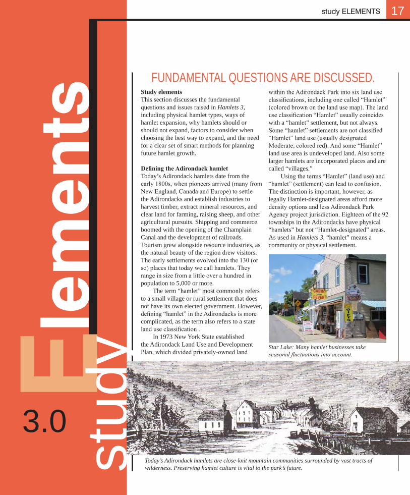
Star Lake: Many hamlet businesses take seasonal fluctuations into account.
Today’s Adirondack hamlets are close-knit mountain communities surrounded by vast tracts of wilderness. Preserving hamlet culture is vital to the park’s future.
17
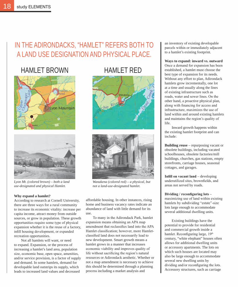
within the Adirondack Park into six land use classifications, including one called “Hamlet” (colored brown on the land use map). The land use classification “Hamlet” usually coincides with a “hamlet” settlement, but not always. Some “hamlet” settlements are not classified “Hamlet” land use (usually designated Moderate, colored red). And some “Hamlet” land use area is undeveloped land. Also some larger hamlets are incorporated places and are called “villages.” Using the terms “Hamlet” (land use) and “hamlet” (settlement) can lead to confusion. The distinction is important, however, as legally Hamlet-designated areas afford more density options and less Adirondack Park Agency project jurisdiction. Eighteen of the 92 townships in the Adirondacks have physical “hamlets” but not “Hamlet-designated” areas. As used in Hamlets 3, “hamlet” means a community or physical settlement.
18
an inventory of existing developable parcels within or immediately adjacent to a hamlet’s existing footprint.
Ways to expand: inward vs. outward Once a demand for expansion has been established, a hamlet must choose the best type of expansion for its needs. Without any effort to plan, Adirondack hamlets grow incrementally, one lot at a time and usually along the lines of existing infrastructure such as roads, water and sewer lines. On the other hand, a proactive physical plan, along with financing for access and infrastructure, maximizes the use of land within and around existing hamlets and maintains the region’s quality of life.
Inward growth happens within the existing hamlet footprint and can include:
Building reuse – repurposing vacant or obsolete buildings, including vacated schoolhouses, obsolete factories/mill buildings, churches, gas stations, empty storefronts, carriage houses, seasonal cottages, and garages.
Infill on vacant land – developing underutilized sites, brownfields, and areas not served by roads.
Dividing / reconfiguring lots – maximizing use of land within existing hamlets by subdividing “estate”-size lots large enough to accommodate several additional dwelling units.
Existing buildings have the potential to provide for residential and commercial growth inside a hamlet. Reconfiguring large, 19th century, “white elephant” houses often allows for additional dwelling units or accessory apartments. The lots on which such houses are located may also be large enough to accommodate several new dwelling units by dividing and/or reconfiguring the lots. Accessory structures, such as carriage
HAMLET BROWN HAMLET RED
IN THE ADIRONDACKS, “HAMLET” REFERS BOTH TO A LAND USE DESIGNATION AND PHYSICAL PLACE.
Lyon Mt. (colored brown) – both a land use-designated and physical Hamlet.
Wanakena (colored red) – a physical, but not a land-use-designated hamlet.
study ELEMENTS
Why expand a hamlet? According to research at Cornell University, there are three ways for a rural community to increase its economic vitality: increase per capita income, attract money from outside sources, or grow in population. These growth opportunities require some type of physical expansion whether it is the reuse of a factory, infill housing development, or expanded recreation opportunities.
Not all hamlets will want, or need to expand. Expansion, or the process of increasing a hamlet’s land area, population size, economic base, open space, amenities, and/or service provision, is a factor of supply and demand. In some hamlets, demand for developable land outstrips its supply, which leads to increased land values and decreased
affordable housing. In other instances, rising home and business vacancy rates indicate an abundance of land with little demand for its use. To many in the Adirondack Park, hamlet expansion means obtaining an APA map amendment that reclassifies land into the APA Hamlet classification; however, more Hamlet-classified land does not necessarily lead to new development. Smart growth means a hamlet grows in a manner that increases economic viability and improves quality of life without sacrificing the region’s natural resources or Adirondack aesthetic. Whether or not a map amendment is necessary to achieve this should be determined through a planning process including a market analysis and
Adaptive reuse of obsolete buildings• Infill on vacant / underused sites• Dividing / reconfiguring lots•
19
houses may also have the potential for reuse. Vacant sites located within the existing framework of the hamlet offer additional potential for inward growth.
Outward growth offers the opportunity to extend beyond the existing hamlet footprint and can include:
Contiguous sites at the edge – extending the hamlet footprint to vacant adjacent land that currently lacks access.
Linear hamlet extension – building incrementally one lot at a time along existing roads stringing away from hamlet centers.
Discrete development areas – developing hinterland sites not adjacent but well connected to existing hamlet centers.
Sites adjacent to hamlets may become extensions of the existing neighborhood and are often best suited for outward development as roads and utilities can be readily lengthened. Linear corridors are probably the easiest way to expand outward as their access and infrastructure already exists. However, this type of growth can lead to strip or ribbon development reducing a hamlet’s visual quality and fostering automobile dependency. Development in the hinterlands, away from the hamlet and related to existing recreational facilities, can be considered smart growth if carefully planned to prevent sprawl.
Communities should consider both inward and outward expansion options but always seek inward options first. In spite of the varying challenges described here, inward expansion offers the most potential to achieve smart growth.
INWARD – WITHIN HAMLET FOOTPRINT
OUTWARD – BEYOND HAMLET FOOTPRINT
InWARd VS OUTWARd
Contiguous sites at the edge• Linear hamlet extension• Discrete development areas•
study ELEMENTS
Inward
In�ll on vacant/underused sites
Adaptive reuse of obsolete buildings
Re-dividing/recon�guring lots
Inward
InwardLinear hamlet extension
Outward
Discrete development areasOutward
Contiguous sites at the edgeOutward
WAyS TO EXPAnd
Hamlets 3 introduces the concepts of “overlay”, “greenbelt” and inward-outward expansion.
Diagrams of a fictional Adirondack hamlet show six ways to expand.
20
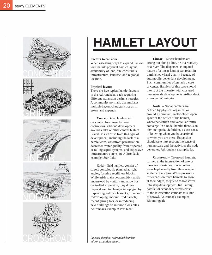
Linear – Linear hamlets are strung out along a line, be it a roadway or a river. The dispersed, elongated nature of a linear hamlet can result in diminished visual quality because of automobile-dependant development. Such communities often lack a core or center. Hamlets of this type should interrupt the linearity with clustered human-scale developments. Adirondack example: Wilmington
Nodal – Nodal hamlets are defined by physical organization around a dominant, well-defined open space at the center of the hamlet, where pedestrian and vehicular traffic converge. In a nodal hamlet there is an obvious spatial definition, a clear sense of knowing when you have arrived or when you are there. Expansion should take into account the sense of human scale and the activities the node generates. Adirondack example: Jay
Crossroad – Crossroad hamlets, formed at the intersection of two or more transportation routes, often grew haphazardly from their original settlement nucleus. When pressures for expansion force hamlets to grow at their edges, they tend to transform into strip development. Infill along parallel or secondary streets close to the intersection combats this kind of sprawl. Adirondack example: Bloomingdale
CONCENTRIC
GRID
LINEAR
NODAL
CROSSROAD
study ELEMENTS
HAMLET LAyOUTFactors to considerWhen assessing ways to expand, factors will include physical hamlet layout, availability of land, site constraints, infrastructure, land use, and regional location.
Physical layoutThere are five typical hamlet layouts in the Adirondacks, each requiring different expansion design strategies. A community normally accumulates multiple layout characteristics as it grows and expands.
Concentric – Hamlets with concentric form usually have continuous “ribbon” development around a lake or other central feature. Several issues arise from this type of development, including the lack of a hamlet core, waterfront privatization, decreased water quality from dispersed or failing septic systems, and expensive infrastructure extension. Adirondack example: Star Lake
Grid – Grid hamlets consist of streets consciously planned at right angles, forming rectilinear blocks. While grids make communities easily understood by visitors and allow for controlled expansion, they do not respond well to changes in topography. Expanding within a hamlet grid requires redeveloping underutilized parcels, reconfiguring lots, or introducing new buildings on interior-block sites. Adirondack example: Port Kent.
Layouts of typical Adirondack hamlets inform expansion design.
21
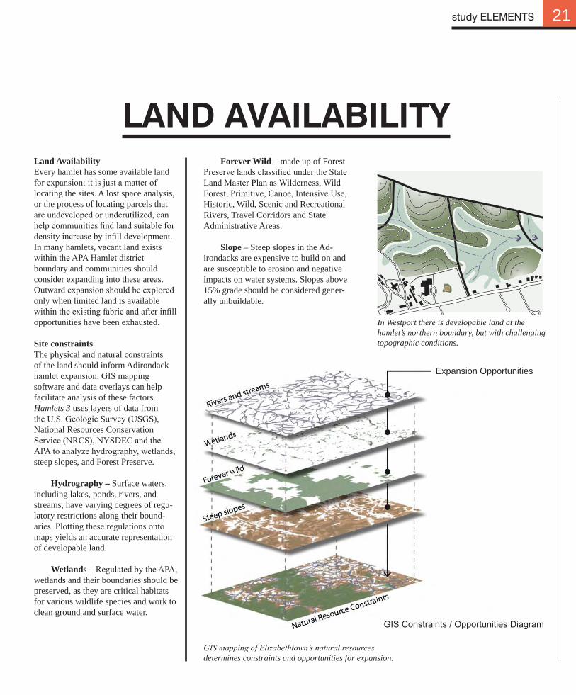
Land AvailabilityEvery hamlet has some available land for expansion; it is just a matter of locating the sites. A lost space analysis, or the process of locating parcels that are undeveloped or underutilized, can help communities find land suitable for density increase by infill development. In many hamlets, vacant land exists within the APA Hamlet district boundary and communities should consider expanding into these areas. Outward expansion should be explored only when limited land is available within the existing fabric and after infill opportunities have been exhausted.
Site constraintsThe physical and natural constraints of the land should inform Adirondack hamlet expansion. GIS mapping software and data overlays can help facilitate analysis of these factors. Hamlets 3 uses layers of data from the U.S. Geologic Survey (USGS), National Resources Conservation Service (NRCS), NYSDEC and the APA to analyze hydrography, wetlands, steep slopes, and Forest Preserve.
Hydrography – Surface waters, including lakes, ponds, rivers, and streams, have varying degrees of regu-latory restrictions along their bound-aries. Plotting these regulations onto maps yields an accurate representation of developable land.
Wetlands – Regulated by the APA, wetlands and their boundaries should be preserved, as they are critical habitats for various wildlife species and work to clean ground and surface water.
LAnd AVAILABILITyForever Wild – made up of Forest
Preserve lands classified under the State Land Master Plan as Wilderness, Wild Forest, Primitive, Canoe, Intensive Use, Historic, Wild, Scenic and Recreational Rivers, Travel Corridors and State Administrative Areas.
Slope – Steep slopes in the Ad-irondacks are expensive to build on and are susceptible to erosion and negative impacts on water systems. Slopes above 15% grade should be considered gener-ally unbuildable.
study ELEMENTS
In Westport there is developable land at the hamlet’s northern boundary, but with challenging topographic conditions.
GIS mapping of Elizabethtown’s natural resources determines constraints and opportunities for expansion.
Expansion Opportunities
GIS Constraints / Opportunities Diagram
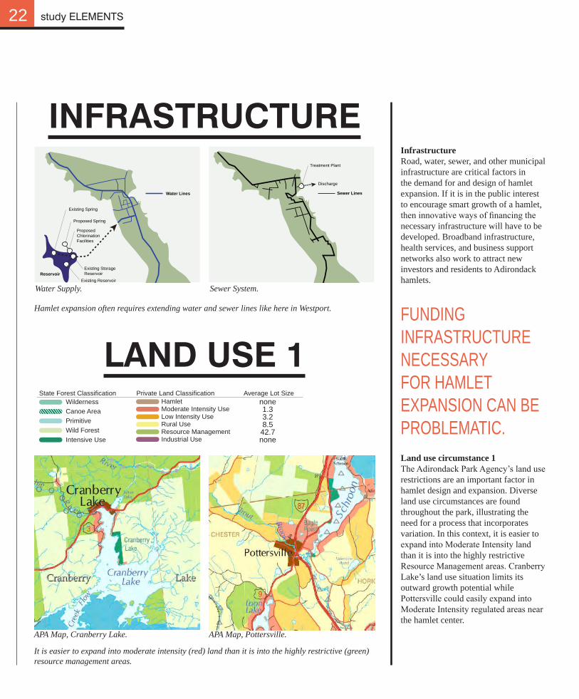
InfrastructureRoad, water, sewer, and other municipal infrastructure are critical factors in the demand for and design of hamlet expansion. If it is in the public interest to encourage smart growth of a hamlet, then innovative ways of financing the necessary infrastructure will have to be developed. Broadband infrastructure, health services, and business support networks also work to attract new investors and residents to Adirondack hamlets.
InFRASTRUCTURE
LAnd USE 1
APA Map, Cranberry Lake.
Water Supply.
APA Map, Pottersville.
Sewer System.
22 study ELEMENTS
Existing Spring
Proposed Spring
Proposed ChlorinationFacilities
ReservoirExisting StorageReservoir
Existing Reservoir
Water Lines
Tr ment P nt
Disc e
Sewer Lines
Treatment Plant
Discharge
Land use circumstance 1The Adirondack Park Agency’s land use restrictions are an important factor in hamlet design and expansion. Diverse land use circumstances are found throughout the park, illustrating the need for a process that incorporates variation. In this context, it is easier to expand into Moderate Intensity land than it is into the highly restrictive Resource Management areas. Cranberry Lake’s land use situation limits its outward growth potential while Pottersville could easily expand into Moderate Intensity regulated areas near the hamlet center.
Hamlet expansion often requires extending water and sewer lines like here in Westport.
It is easier to expand into moderate intensity (red) land than it is into the highly restrictive (green) resource management areas.
FUNDING INFRASTRUCTURE NECESSARY FOR HAMLET EXPANSION CAN BE PROBLEMATIC.
HamletModerate Intensity UseLow Intensity UseRural UseResource ManagementIndustrial Use
none1.33.28.542.7none
State Forest Classification Private Land Classification Average Lot SizeWildernessCanoe AreaPrimitiveWild ForestIntensive Use
23
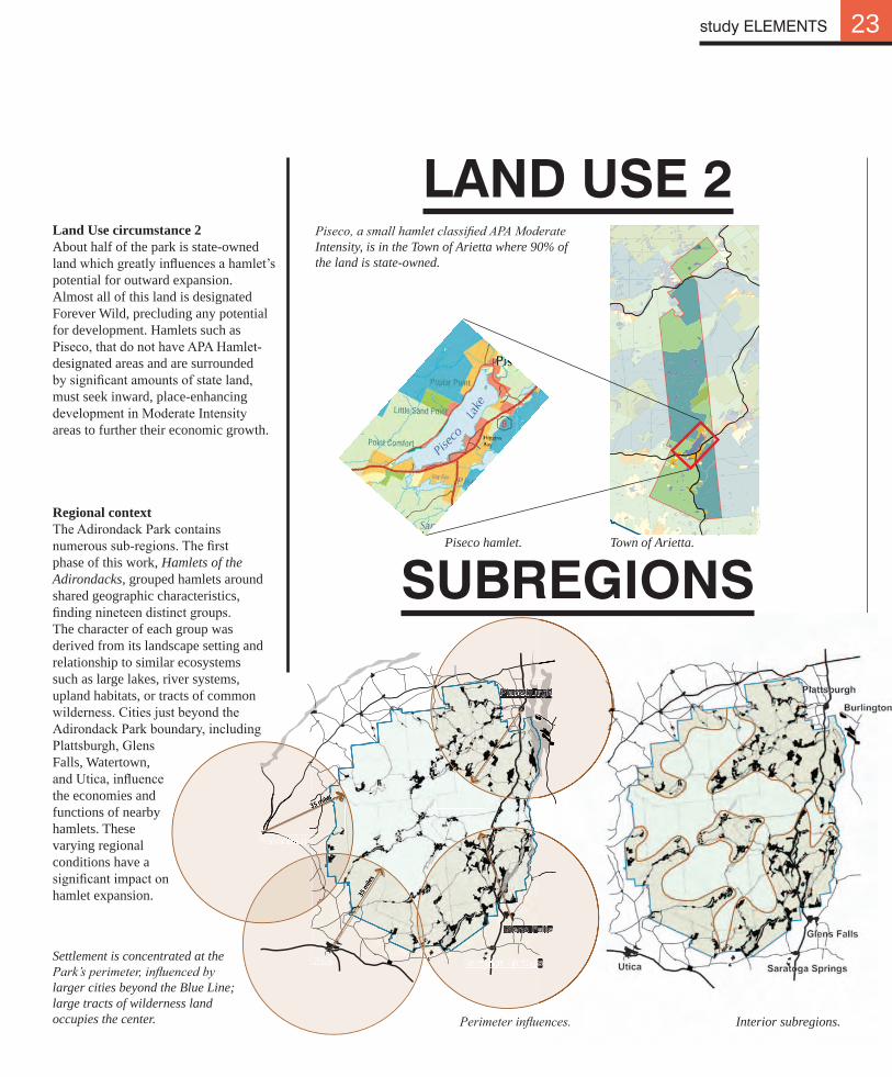
Land Use circumstance 2About half of the park is state-owned land which greatly influences a hamlet’s potential for outward expansion. Almost all of this land is designated Forever Wild, precluding any potential for development. Hamlets such as Piseco, that do not have APA Hamlet-designated areas and are surrounded by significant amounts of state land, must seek inward, place-enhancing development in Moderate Intensity areas to further their economic growth.
LAnd USE 2
SUBREgIOnS
Interior subregions.
Piseco, a small hamlet classified APA Moderate Intensity, is in the Town of Arietta where 90% of the land is state-owned.
35 m
iles
35 miles35 miles35 miles35 miles35 miles
study ELEMENTS
Regional contextThe Adirondack Park contains numerous sub-regions. The first phase of this work, Hamlets of the Adirondacks, grouped hamlets around shared geographic characteristics, finding nineteen distinct groups. The character of each group was derived from its landscape setting and relationship to similar ecosystems such as large lakes, river systems, upland habitats, or tracts of common wilderness. Cities just beyond the Adirondack Park boundary, including Plattsburgh, Glens Falls, Watertown, and Utica, influence the economies and functions of nearby hamlets. These varying regional conditions have a significant impact on hamlet expansion.
Settlement is concentrated at the Park’s perimeter, influenced by larger cities beyond the Blue Line; large tracts of wilderness land occupies the center. Perimeter influences.
Piseco hamlet. Town of Arietta.
CLUSTERS
24
L C O E T
CENTER-SATELLITE
MULTI-NODAL
URBAN SYMBIOSISHAMLET NECKLACE
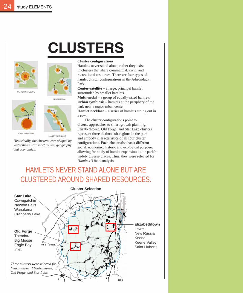
Cluster configurationsHamlets never stand alone; rather they exist in clusters that share commercial, civic, and recreational resources. There are four types of hamlet cluster configurations in the Adirondack Park: Center-satellite – a large, principal hamlet surrounded by smaller hamlets.Multi-nodal – a group of equally-sized hamletsUrban symbiosis – hamlets at the periphery of the park near a major urban center.Hamlet necklace – a series of hamlets strung out in a row. The cluster configurations point to diverse approaches to smart growth planning. Elizabethtown, Old Forge, and Star Lake clusters represent three distinct sub-regions in the park and embody characteristics of all four cluster configurations. Each cluster also has a different social, economic, historic and ecological purpose, allowing for study of hamlet expansion in the park’s widely diverse places. Thus, they were selected for Hamlets 3 field analysis.
Cluster Selection
study ELEMENTS
Old ForgeThendaraBig MooseEagle BayInlet
ElizabethtownLewisNew RussiaKeeneKeene ValleySaint Huberts
Star LakeOswegatchieNewton FallsWanakenaCranberry Lake
t
ngst
W t t wn
t
HAMLETS NEVER STAND ALONE BUT ARE CLUSTERED AROUND SHARED RESOURCES.
Historically, the clusters were shaped by watersheds, transport routes, geography and economics.
Three clusters were selected for field analysis: Elizabethtown, Old Forge, and Star Lake.