fundamental infrastructure for spatially enabled...
TRANSCRIPT

Keith Clifford Bell
Fundamental Infrastructure for Spatially Enabled Societies`
May 10, 2018

Presentation Outline
❖ Overview of World Bank
❖ New Approaches to Development Investment
❖ Overview of Global Land Portfolio
❖ Global Trends
❖ Investment in Modern Land Administration Systems& NSDI
❖ Opportunities
❖ Global Fora & Advocacy
❖ Final Remarks ☺
2

International Bank for
Reconstruction and
Development (IBRD)1944
1956
International
Development Association
(IDA)1960
1988
1966
Over 10,000 employees
Over 5,000 consultants
120 country offices

WBG is one of the world’s largest sources of funding and knowledge for developing countries, and is committed to reducing poverty, increasing shared prosperity, and promoting sustainable development.
• Overall WBG Financing: FY 2017, WBG provided nearly US$59 billion in loans, grants, equity investments, and guarantees to partner countries and private businesses—including to multiregional and global projects.*
• Land-related Project Financing: Globally, since 1980, WBG has financed over 70 Land projects, in at least 42 countries, with commitments of around US$3 billion.
*Source: http://pubdocs.worldbank.org/en/982201506096253267/AR17-World-Bank-Lending.pdf
WBG Financing

Sustainable Development Goals
5


7
MFD – Maximizing finance for development
• systematically leverage all sources of finance, expertise, & solutions to support developing
countries’ sustainable growth
• countries’ resource needs surpass their own budgets and available donor funding.
• consider a spectrum of solutions, private as well as public – help tap a variety of financing
opportunities, incorporate global lessons and good practices, and address equity and
affordability for consumers.
Harnessing Technologies - Including disruptive technologies in the Bank Group's work to in
support of new pathways to growth
• Build: Develop the foundational building blocks for sustainable, technology-led economies
• Boost: Expand the capacity of people and institutions to thrive in a resilient society
• Broker: Harness disruptive technology, data, and expertise to solve development challenges
and manage risks through collaborations
To apply a FIG term fit-for-purposeembracing both MFD and harnessing technology (both disruptive and
foundational) requires a savvy engagement with countries, understanding their
needs, governance, political economy and citizen engagement.

The Current WB Land Portfolio
• Active Projects: 11 operations ($723 M)
• Pipeline (next 18 months): 11 operations ($698 M)
• Analytical and Technical Assistance: 20+ tasks
• Two Reimbursable Advisory Services ($11.8m)
• 15 Trust-Funded activities
From To

Global Partnerships
Cooperative Programme

Increase of population
another 2 billion tons of cereals
another 200 million of meat
another 130 million of oilseeds
Needs of…
2 to 3 billion by 2050
60% increase in agricultural production

Global TrendsNatural Disasters Frequency & Severity
increasing
❖ Links to Climate Change
❖ Other causes of natural disasters
Resilience requires spatial enablement

Global Trends: Displaced persons*
❖An unprecedented 65.6 million people around the world have been forced from home. Among them are nearly 22.5 million refugees, over half of whom are under the age of 18.
❖There are also 10 million stateless people who have been denied a nationality and access to basic rights such as education, healthcare, employment and freedom of movement.
❖In a world where nearly 20 people are forcibly displaced every minute.
❖Turkey is the top hosting country for refugees
Displaced persons need shelter, nutrition, security, ID, etc.
Solutions require access to land and to be spatially enabled
Source: UNHCR , Jun 19, 2017
http://www.unhcr.org/figures-at-a-glance.html

GéoCongrès, Québec 2007
1970
RURAL
63%
URBAN
37%
2000 2030
RURAL
53%
URBAN
47%
RURAL
40%
URBAN
60%
Population: rurale/urbaine
2 billion new urban residents
1.2 million new km2 urban area+
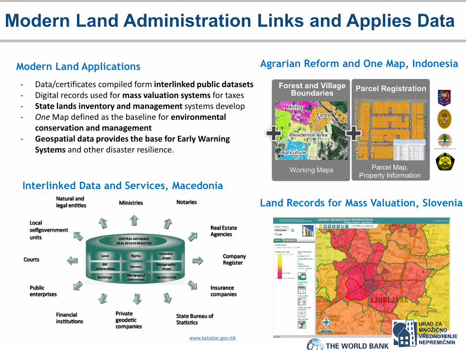
Agrarian Reform and One Map, IndonesiaModern Land Applications
Interlinked Data and Services, Macedonia
- Data/certificates compiled form interlinked public datasets- Digital records used for mass valuation systems for taxes- State lands inventory and management systems develop- One Map defined as the baseline for environmental
conservation and management- Geospatial data provides the base for Early Warning
Systems and other disaster resilience.
Land Records for Mass Valuation, Slovenia
www.katastar.gov.mk
URAD ZA
MNOŽIČNO
VREDNOTENJE NEPREMIČNIN


Important for (value adding)
investments:
– Clear tenure
– Transparency of markets/values
– Availability of data
– Incentivized stakeholders
Source: http://www.uitp.org/

80% of humanity live below US$10.00 a day or where 70% of humanity do not have
clear legally & spatially defined land or property rights ….”Source: Childress, M., Bell, K.C. & Cheehai, T., 2014, Spatial Innovation & Good Practices in Land Administration Forum, Report of the Joint World
Bank-FIG Forum held March 28, 2014, Washington D.C., Coordinates, May 2014.
Source: NYC - depositphoto.com

Some of the Notable Characteristics of Land Sector*
❖Colonial legacies embedded in land administration systems, laws & institutions.
❖Land related conflicts that have persisted over the years.
❖Frequent occurrences of natural disasters.
❖High proportion of forestry lands, Indigenous Peoples & forest-dependent communities who hold land in accordance with customary tenure arrangements.
❖Large-scale investments in land (e.g., forestry, agriculture, palm oil & mining concessions – especially FDI).
❖Land acquisition challenges.
❖Rapid pace of urbanization & emergence of mega-cities.
❖Strong interest & growing investment in SDI & related
Understanding the political economy of land in each country is an essential pre-requisite for engagement.
*Not all are applicable to all regions of the world

Substantial Financing required for building land records and infrastructure
and retaining specialist personnel
- Failed financing leads to poor systems, data and
services
Monopoly Commodity (transaction registration) as the core business
line creates vulnerabilities
- Petty and grand corruption- Wealth accumulation

The IDPL Architecture
Geo-Information Infrastructure
•Geodetic Infrastructure and Base Mapping
•Land Information system
• Information Communications Technology (ICT)
Land Administration System
•Cadastre
•Land Register
Land Policy and Capacity Development
•Land Code
•Technical Training Institute (TTI)
The IDPL consists of the following 3 inter-related components and 7 sub-components:
Pro
gram
me
Man
age
me
nt
Un
it
(PM
U)

TURKEY: 3D City Model Production Project

1
2
3

National Land and Geospatial System Resilience
• Land administration systemsprovide secure tenure reducing vulnerability, and the baseline for estimating disaster damages and eligibility for support
• NSDI provides the common location platform for identifying the impact, directing responses, reconstituting the pre-disaster land use, identifying areas for temporary shelter, and facilitating planning and reconstruction.


1. Develop an overarching Geospatial Framework for countries to reference when developing their national and sub-national spatial data infrastructures (SDIs).
To be endorsed by member states August 2018
2. Assist countries to prepare and implement Country-level Action Plans to operationalize the Geospatial Framework
“Bridging the Geospatial Digital Divide”: Two Key Activities

• Land rights are key for shelter, livelihoods, identity, security ...
• Yet many, especially women, lack secure rights to land.
• SDGs (1.4.2 and 5a) require reporting and action on women’s access
to land.
• Good laws not enough – implementation and impact on women
matters.
• Change in social norms required – long term effort.
• Improving women’s land rights is right and also good economics!
• The global advocacy campaign will be launched with WBG support to
raise attention and action on the importance of secure land rights to
women.

Sustainable Societies Must be Spatially-Enabled
INCLUSIVE COMPETITIVERESILIENTCLEAN AND
EFFICIENT
And land is at the center of it all…

Final Remark: It is About Rights!
“The technocratic illusion is that poverty results from a shortage of expertise, whereas poverty is really about a shortage of rights.”Easterly, W., 2013, The Tyranny of Experts. Economists, Dictators, and the Forgotten Rights of the Poor.
Access to land & spatial enablementare fundamental to redressing the shortage of rights
Pic Source: The Guardian, Jun 30, 2010