functional economies or administrative units in greece ... · functional economies or...
TRANSCRIPT

CENTRE OF PLANNING AND ECONOMIC RESEARCH
No 86
Functional Economies or Administrative Units in Greece:
What Difference does it make for Policy?
Prόdromos-Ioánnis Prodromídis
February 2006 Prόdromos-Ioánnis Prodromídis Research Fellow Centre of Planning and Economic Research, Athens, Greece

FUNCTIONAL ECONOMIES OR ADMINISTRATIVE UNITS IN GREECE:
WHAT DIFFERENCE DOES IT MAKE FOR POLICY?
1. Introduction
The purpose of this paper is to construct an incomes map of Greece at the local unit level, and
econometrically study the impact of regional and other factors on income formation. To that end,
we employ the population figures of the 2001 Census provided at the municipal level, and the 2002
Revenue Service personal income-figures pertaining to the declared earnings in the census year,
provided at the post-code level.1 Given that we will be making use of data provided at different
geographic levels, some amalgamation is required.2 Consequently, we reorganize the population
and revenue data by matching/aggregating them exactly at the same level (ward by ward) into 895
territorial units, some of which are urban municipalities, and the remaining are rural postal districts.
Most studies pertaining to regional income, prosperity, and output in Greece are conducted at the
administrative region and county levels, i.e., NUTS levels 2 and 3, respectively.3 Among these are
recent works by Athanassiou et al. (1995), Siriopoulos and Asteriou (1998), Petrakos and Saratsis
(2000), Tsionas (2002), Christopoulos (2004), Christopoulos and Tsionas (2004). However, empiri-
cal research at the local community level is still embryonic in Greece. Yet, the advantages of (a)
being able to distinguish between towns and clusters of communities, urban and rural sub-regions,
instead of smudging them within a county or region, and (b) running multivariate regressions with
large, disaggregated samples, are profound.
1 The Census statistics were provided by the National Statistical Office of Greece [NSOG]. The Revenue Service fig-ures were provided by the General Secretariat on Information Systems, of the Ministry of the Economy & Finance [MEF]. The two were matched via the geographic dataset on administrative districts, provided by the Land Survey and Chartography Service, and the outcome has been deposited in the KEPE Data Archive with the designation Greek Re-gional Economic Statistics I (GRES I for short). 2 Indeed, urban municipalities consist of several postal districts, whereas most rural postal districts tend to encompass more than one municipality and/or communities from different municipalities, depending on the configuration of land. 3 The Nomenclature des Unités Territoriales Statistiques [NUTS] is the five-tier hierarchical structure used in the EU to standardize territorial units (EU, 2004a). Thus, the broad sub-national administrative regions are classified as NUTS level 2 sized-districts, counties or prefectures/nomes as NUTS level 3, municipalities or boroughs as upper level Local Administrative Units (LAU 1, occasionally termed NUTS level 4), municipal departments or wards as lower level LAU (or LAU 2, occasionally referred to as NUTS level 5).

Studies at the international level by Bramley and Smart (1996), Bramley and Lancaster (1998),
Caldwell et al. (1998), Green (1998), and the literature cited therein, are already filling the gap in
regional economics through the study of spatially disaggregated data at the community, postcode or
municipality level. They propose that average incomes vary depending on age, human capital,
household and production composition, the local cost of living, the area’s attractiveness, remote-
ness, industrialization, population density, and region.4 Moreover, the study of disaggregated data is
also useful for other exercises. For instance, and in relation to the EU regional development funding
system, Greenbaum and Bondonio (2004) show that if we shift the focus from the regional to the
finer geographical level of towns (i.e., from NUTS 2 to LAU 2), we note that the EU structural pro-
grams designed to revitalize distressed areas expand to include the less distressed areas. In the pre-
sent analysis, the examination of data extracted from fine geographic units enables us to suggest
that the territorial framework employed by regional policy planners may have to be modified in or-
der to better depict the real situation and promote convergence.
Indeed, we find that the spatial scatter of average incomes across communities reveals no obvi-
ous correspondence to the territorial divisions used for regional development policy. In fact, the
emerging pattern of prosperous and poor localities is of a distinctly different sort. So, when com-
pared to alternative specifications, the econometric model built around the formal territorial system
provides an inferior, less efficient mode of analyzing residents’ economic performance. These find-
ings imply the presence of a zoning effect in the grouping of area units (Amrhein, 1995), which -in
turn- reinforces the view that we should take a fresh look at the economy as it truly is, i.e., a collec-
tion of clusters and often dissimilar communities, without preconceptions that certain territorial
units or sub-regions must fit in an inherited regional framework -even if this is the framework on
the basis of which an aggregate prosperity indicator is estimated and regional policy is traditionally
decided and funded. In short, it would appear that although the territorial framework adopted by the
4 However, the variables and composite indicators used in these studies (where available) are not comparable to the variables available in the Greek dataset considered here.
2

Administration affects and shapes the economy, it may also be improved to serve as a more appro-
priate instrument of economic development. Additionally, our results point in the direction of a
number of regional and broader policy proposals aiming to promote economic performance and
prosperity across Greece.
The rest of the paper is organized as follows: Section 2 offers a brief country report in terms of
the data accompanied by a deliberation on the country’s territorial organization. Section 3 provides
an income-formation model on the basis of which Section 4 estimates variant econometric specifi-
cations. Finally, Section 5 offers the main conclusions.
2. The geographic, administrative, demographic, and income landscape of Greece
Located at the southern part of the Balkan peninsula, in south-east Europe, Greece covers an area of
132,036 square kilometers. As illustrated in Map 1, the terrain is dominated by high mountain-
chains, landlocked valleys, narrow coastal strips, a multitude of islands,5 and a very jagged coast-
line.6 These natural features greatly fragment the country into a host of tiny districts.7 Obviously,
the splintering impact of the landscape is tempered by the effectiveness of the transportation net-
work linking these districts (coastal strips, plateaus, and islands). However, the Greek road, rail, sea
and air transport system is still rather inadequate by modern Western European standards.8
5 I.e., nearly 3.8 thousand islands and 6 thousand islets, each constituting a separate economic area. 6 The coastline extends for 15 thousand kilometres, accounting for over a fifth of the current EU-25 total, all packed in a rather small area, no more than 3.5 % of the EU’s landmass. 7 Indeed, it is commonplace among modern historians (e.g., Starr, 1991: 186-8) to trace the creation, diversity and inter-national interaction of the distinct self-ruling little city-states and tribal kingdoms of early and classical antiquity (e.g., Corinth, Sparta, Athens, Thebes, Delphi, Ithaca, Molossis, Macedon, Rodos [Rhodes], etc.) to this divisive landscape. 8 As indicated in Map 1, on the mainland, the primary highway links Patras (P), Athens (A), Thessaloniki (T) and the lower Axios valley up to the ex-Yugoslav border. In the course of the 1990s, the highway was expanded to include the Patras-Olympia (P-O), Corinth-Tripolis (C-Tr), Thessaloniki-Veria (T-B) routes. However, the remaining west-east and north-south automotive transportation is conducted through secondary and local roads, chiseled on cliffs, twisting up and down mountain slopes, traversing or meandering through the few passages afforded between the mountain-ridges, narrow river valleys and the coastal strips. Of the islands, only Crete, the largest one, possesses a high-standard motor-way, running east-to-west along the northern coastline, linking the four county-seats and three airports. The main rail-line also runs along the Patras-Athens-Thessaloniki-Axios axis. It is supplemented by a southern circuit (in the palm-like peninsula) whose infrastructure is partially outdated, a midland east-west line around Larisa (La), and a northern network linking Thessaloniki to all county-seats and lowland border-crossings along the former Yugoslav, Bulgarian and Turkish border. It has yet to penetrate the Pindos massif dividing the mainland into east and west; and
3

4
As indicated in Map 2, administratively the country is organized in thirteen administrative re-
gions (NUTS level 2), namely, Attiki, Central Greece, Peloponnesos, Western Greece, Thessaly,
Epiros, West Macedonia, Central Macedonia, East Macedonia & Thrace, the North Aegean Islands,
the South Aegean Islands, the Ionian Islands, and Crete. These regions are subdivided into 51 pre-
fectures (NUTS 3) consisting of 1,478 postal districts or 1,036 municipalities (LAU 1) that are fur-
ther subdivided into 6,130 wards (LAU 2); and as stated in the introduction, for the purposes of our
analysis, these wards are reorganized in 895 territorial units, some of which are municipal and oth-
ers are postal districts.
According to the 2001 Census, the country is inhabited by some 10.9 million people. The major-
ity lives in private homes, whether alone (6.61%) or with other relatives (87.27%), in settlements of
over two thousand people (72.78%). Of these, the largest conurbations are located around Athens-
Piraeus (A) in Attiki, hosting a reported population of 3,588 thousand people (indicated in Map 2
with black and grey), Thessaloniki (T) in Central Macedonia, with 914 thousand people,9 Patras-
Rio-Antirio (P) in Western Greece, with 213 thousand people, followed by Irakleio (I) in Crete,
Larisa (La) and Volos (V) in Thessaly, and Ioannina (Io) in Epiros, each inhabited by 160-120 thou-
sand people. The majority are Greek nationals (93.04%). There also exist communities of other EU
nationals (0.04%) and non-EU nationals (6.52%). About 5.41% is employed in the primary
according to the OECD (2004), in 2001-2 afforded the lowest freight and passenger transport per kilometer among the networks of the (then) 15 EU member-states. Of course, a great deal of transport is conducted over the water. Of the existing 750 natural harbors and gulfs, nearly 150 are fitted with ports. These are served by 400 ferries and hydrofoils, performing 1200 port-to-port routes in order to link the various economic spaces, at least once a week, weather permitting. However, several of the 112 islands that remain inhabited are not (directly) linked to the major markets of the mainland, and several shipping-lines involving remote or small communities are not profitable to maintain. As for air-transport, the mainland is equipped with nine airports that serve as satellites of the Athens international air-port. All are located outside a 250 km radius from Athens, apparently spaced so as to correspond to broad geographic regions, and service their relations with Athens. All sixteen large islands beyond the 140 km radius from Athens are also equipped with airports, and the largest, Crete, is fitted with three. (Among the large islands without airports are Andros [An] and Tinos [Ti] that are situated close to Athens [2-3 hours by ship], Thasos [Th] that is situated near Kavala [Ka], and Lefkas that shares an airport with Preveza [LP]). The air-transport system is supplemented by nine airports located on smaller islands that either form part of small-island clusters (such as Skiathos [S] in the Sporades, Leros [Le] in the northern Dodecanese, Megisti [M] in the southern Dodecanese) or constitute major tourist destinations, e.g., Mikonos (Mi) and Thira (Santorini) (Th). 9 Of these, 691 thousand people reside in the area indicated in Map 2 with dark gray, and 223 thousand live in the less prosperous belt indicated with blue, sandwiched by the gray-colored area.

MAP 1: The geography of Greece and an outline of the road, rail, and airport networks
Key to locations
A Athens Al AlexandroupoAn Andros B Veria c Kalavrita C Corinth F Florina Ig Igoumenitsa k Kiparissia K Kalamata Ka Kavala Kz Kozani L Loudias deltaLa Larisa Le Leros LP Lefkas-PreveM Megisti Mi Mikonos o Ormenio O Olympia P Patras Pr Promahon S Skiathos T Thessaloniki Th Thasos Ti Tinos Tr Tripolis TS Thira (Santor
lis
za
ini)
Source: The March 26, 2003 image of the Balkans from the Terra satellite (NASA/GSFC, 2003).
Key to map
• Primary road network (yellow) • Recent addition to the primary road
network (yellow-red) • Secondary road network (red) • Railway netword (black) • Airport (red circle) • Country border (purple)
Kerkira (Corfu)
Rodos Crete

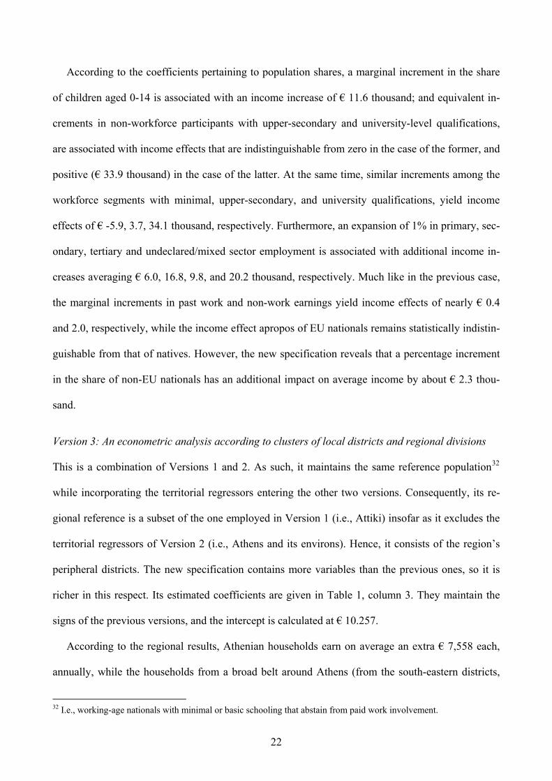
MAP 2: The territorial clusters according to the average declared family incomes from 2001 and the regional division of Greece.
Peloponnesos
Crete I
South
Aegean Islands
Central Aegean Greece
Western Greece
Ionian Islands
A Attiki
East Macedonia & Thrace
Central Macedonia
West T
donia
Thessaly La V North
H Islands
P
Epiros Mace-
Io
Key for color classifications:
Color Areas Average income
Black Athens (A) along with its eastern, northern, and southern suburbs. 13,027-29,700 €
Light gray Athens’ western suburbs and the prosperous south-eastern districts. 11,273-13,478 €
Dark gray Thessaloniki (T) and its environs. 11,315-21,509 €
Red The districts along the highway to Halkis (H). 11,817-13,353 €
Brown The other main nodes of the transportation system. 11,249-14,826 €
Pink The other main tourist sites. 11,245-13,107 €
Purple The other poles of mining and industrial production 11,400-19,399 €
White The remaining areas of Attiki, East Macedonia & Thrace, West Maceconia, Western Greece.
4,505-11,309 €
Yellow The remaining areas of the Ionian Islands, South Aegean Islands, Thessaly. “
Green The remaining areas of North Aegean Islands, Peloponnesos. “
Blue The remaining areas of Central Greece, Central Macedonia, Crete, Epiros (including an outlying postal district in Evia, Central Greece, that reports an average income of 11.844 €).
“
6

sector, 8.15% in the secondary, 21.96% in the tertiary sector, 1.97% in multiple or unspecified sec-
tors, 4.46% is in transition (unemployed), while the remaining 57.83% of the population is ostensi-
bly not pursuing such activities.10
According to the Revenue Service figures for 2001, the aggregate pre-tax income reported was €
61,307 billion, averaging nearly € 12,299 per declaration.11 (In Greece couples file jointly even if
taxed separately. This yields a national average of 2.2 people per declaration.) At the regional level,
Attiki is associated with the highest average household income (€ 14,519), followed by the South
Aegean islands (€ 11,507), Crete (€ 11,359), Central Greece (€ 11,092), Central Macedonia (€
11,090), and the other regions, while the lowest figure pertains to Peloponnesos (€ 10,158).
The consideration of disaggregated data: concerns over the regional development policy design
Similar distributions of average income (in the form of GDP per capita) are currently used by the
national and the EU authorities in order to decide whether a region falls short or exceeds the 75%
level of the EU average,12 which in turn determines the continuation (or suspension) of funding in-
10 In the next section we consider the level of their human capital. In terms of formal education, the Greek workforce comprises of 35.98% of all working-age residents (aged 15 or older) who received 0-9 years of schooling, 59.95% of all who attained upper-secondary education, and 78.67% of those with tertiary-level education, while the rest abstain from paid work. 11 That is a quarter higher than the estimated disposable income of the average Greek household (€ 9,214) reported by that year’s household budget survey (EU, 2005: themes-data-regions). As probably expected, the majority of revenue declarations derive from the most populous municipalities: Athens (9.12%), Thessaloniki (4.14%), Piraeus (2.04%), Patras (1.82%), Irakleio (1.54%), Larisa (1.50%), Volos (1.20%), Ioannina (1.08%), as well as Peristeri (1.54%) and Kallithea (1.29%) that are adjacent to Athens and form part of the metropolitan area. All yield a higher proportion of declarations compared to their reported population share. On the antipodes are the border communities of Molista (in Epiros) and Evzones (in Central Macedonia) with 21 and 8 declarations, respectively. 12 Unfortunately, the Greek sub-national GDP figures are liable to assigning output seemingly created in a region to that region’s residents, even if the particular residents do not actually produce/earn it (Coccossis et al., 2005). In fact, unlike the regional per capita GDP statistics from other EU member-states, the Greek estimates are not very reflective of the residents’ relative prosperity, as evidenced through the household budget survey estimates of people’s disposable in-come: Indeed, according to the available statistics of the EU (2005: themes-data-regions) for 2001, the Greek per capita regional GDP figures exhibit a modest level of correlation (r = 48.5%) with the average household disposable income figures obtained via household budget sample surveys from the same regions. By contrast, the comparable Czech, Fin-nish, French, German, Hungarian, Italian, Polish, Portuguese, Slovak, Spanish, Swedish, and smaller-country (Danish-Irish-Baltic considered collectively) indices exceed the 87% level; the UK and Dutch correlation ratios are at the 70.4% and 60.3% level, respectively; the Belgian index exhibits a lower level of correlation (36.6%); while there is no data from Austria, Cyprus, Luxembourg, Malta, and Slovenia. Considering that the revenue figures employed hereinafter (a) involve incomes earned by each area’s residents (unlike the GDP statistics), and (b) derive from the greater part of the total population in all localities (unlike the rather small samples employed in household budget surveys), they are probably well suited for our purposes (compared to the GDP statistics and household budget surveys).
7

8
tended for regional development and convergence policies to level (upon leveling) the plane field.13
However, empirical economists can do more than contrast averages from large territorial units as a
means for detecting region-specific differences, especially considering that the particular averages
are likely to be affected by demographic, industrial, and other effects that are not region-specific.
By contrast, a multivariate regression technique is a more appropriate treatment for isolating the
effects of various factors and for identifying regional advantages and disadvantages.
Moreover, in several cases, the NUTS 2 areas are not sufficiently unified economic areas to jus-
tify the implementation or discontinuation of economic policies on the basis of aggregate prosperity
indicators extracted from these regions. Indeed, the consideration of a single average figure from
such a broad area is likely to mask sub-regional heterogeneity and to lead to the adoption of inap-
propriate economic policies. To better illustrate this we consider the disaggregated income land-
scape of Central Greece [Map 3], where we identify four types of sub-regions:
a) The belt along the Inofita-Halkis railroad and highway, along with the suburbs of Halkis. It ac-
counts for 3.8% of Central Greece’s total area, attracts 19.9% of the region’s population and
produces 24.2% of its total income.
b) The basic nodes of the regional transportation system: Lamia, Amfissa-Itea, Karpeninisi, and
their environs. They host 17.1% of the population on 9.2% of the land and produce 19.1% of the
total income.
c) The mineral extraction and energy production communities of Aliveri, Distomo, Larimna, along
with the tourist site of Delfi. They exhibit a more balanced combination of population density:
4.7% of the population on 4.6% of the land, producing 6.4% of the region’s income.
13 The EU regional development programs fund infrastructure, competitiveness projects, research & development, inno-vation, human resources, job creation, environmental management (EU, 2004b,c). The issue of Greek regional perform-ance and its comparison to the rest of the EU prior to its eastward enlargement in 2004, is discussed by Armstrong and Vickerman (1995), Petrakos and Saratsis (2000), Button and Pentecost (1999), Le Gallo and Ertur (2003), Rodríguez-Pose and Fratesi (2004), and the sources sited therein.

9
MAP 3: The 2001 average declared family income per community in Central Greece
Key for color classification
Red: Areas with € 11,310 or more. Orange: Other areas in C.Greece, Epiros. Green: Other areas in Peloponnesos. Blue: Other areas in Thessaly, the Ionian Islands. Gray: Other areas in Attiki, W.Greece.
EPIROS
THESSALY
IONIAN ISLANDS
WESTERN GREECE
PELOPONNESOS
North Evia Skiros
Karpenisi Lamia
Amfissa
Itea
Delfi
Distomon
Larimna
Aliveri
Athens ATTIKI
South Evia
Halkis
Inofita

d) The remaining (mostly rural) areas. They account for 82.3% of the area, and are inhabited by
58.1% of the population who produce 48.0% of the region’s income.
On average, the annual average income in the developed districts (a)-(c) is € 16.6 thousand, and in
the countryside (d) is € 9.7 thousand. This suggests an intra-region disparity ratio of 10:6.
Consequently, when the national and EU regional-development authorities look at the regional
average to compare it to the 75% EU prosperity threshold, to decide on whether they should provide
development funding, they loose sight of the countryside’s relative poverty and the disproportional
contribution of the Inofita-Halkis cluster linked to Athens (which enjoys the spillovers from its
proximity to Athens). As a result, they are left with the mistaken impression that the whole region
prospers,14 even as the large area -east and west of the Inofita-Halkis cluster- remains very much
mountainous, divided by the two Euboean Gulfs, and in need of transportation infrastructure in or-
der to integrate and enjoy spillovers from the capital.15
Yet, without the guidance or operation of a regional development policy that introduces infra-
structure and alters the landscape, as history teaches, the proverbial invisible hand will direct the
available human resources to their presumed land of opportunity. Consequently, as wealthy areas
remain (or become more) attractive, the continued depopulation of the disadvantaged area (82.2%
of Central Greece), in favor of the cluster linked to Athens or Athens itself, is a likely scenario.16
And as the rural population relocates to the new prosperous conurbation and/or Athens to earn a
higher wage, the population-weight of the poorer, rural sub-region will dwindle, while the popula-
tion-weight of the wealthier place will rise. Accordingly, the average income index for Central
14 Consequently, as in 2004 the per capita GDP of the whole region appeared to exceed the EU disparity threshold, Cen-tral Greece was deemed sufficiently prosperous to be dropped off the 2007-13 list of areas eligible for infrastructure and access projects aimed to reduce disparities, although the region had not got around to using but only 12% of the 2000-6 funds approved for its development (MEF, 2004), so that it would cease to be lagging behind. (This was averted/a-mended somewhat after consultiations at the highest political echelons, and the EU Council meeting of December 2006, decided to allow that diversion of some funds for infrastructural purposes.) 15 According to the latest statistics (EU, 2003, map 8.1) that have not been updated since 1996, the region features one of the lowest motorway densities in the EU. 16 Indeed, it is highly likely that this particular process is already occurring: Boeckhout and Haverkate (1995) list Cen-tral Greece as one of the most disadvantaged regions in the EU, in terms of mobility and job opportunities, and accord-ing to the EU (2003, map 1.1), the region continued to experience an overall population reduction between 1996-2000.
10

Greece will continue to rise. This will further impede the diversion of infrastructural funding to the
lagging sub-region, making it rather unlikely that the territorially fragmented countryside (espe-
cially the counties away from the northern highway, such as Evritania, Fokis, north and south Evia,
Skiros) will integrate with the rest any time soon.17 Eventually, by masking the intra-region diver-
sion, the average prosperity index intended to measure regional disparities (in order to divert funds
to underdeveloped areas and rectify the problem by leveling the field) will have worked, ceteris
paribus, to achieve the opposite purpose from that originally intended.
In conclusion, we suggest that the use of average measures drawn at the regional level of a terri-
torially fragmented country, may not only be misleading by masking regional bimodality, but also
be unconstructive; whereas the use of disaggregate territorial indicators is a sine qua non condition
for the purpose of pinpointing disadvantaged areas, and designing regional development policy and
infrastructure projects in large sub-regions.18
The key-roles of the transportation and production features in a new model
Having raised some reservations with regard to the appropriateness of conducting regional policy
on the basis of the country’s current administrative division of the country, we also note that the
spatial scatter of prosperous and poor localities [Map 2] reveals no obvious concentrations or pat-
terns that run along regional lines.19 This is not very surprising, considering the high level of geo-
17 Similarly, in the archipelago, the tourist success of a couple of inlands does not necessarily mean that the remaining (rather isolated and less prosperous) islands enjoy any spillovers. 18 Indeed, the industrial, tourist or other production/trade prospects and welfare of large areas in geographically frag-mented regions such as Central Greece, depend on their internal economic unification, and their connection with the rest of the country. Once unified, these areas will gain access to health on other services that will raise the standard of living and make them attractive to both locals and visitors, and become better qualified to exploit their advantages and become more prosperous. However, if the priorities of regional policy-planners require public funding to be directed elsewhere, then the residents of disadvantaged communities may have to consider (a) relocating to places that can better support higher living standards or (b) setting up the necessary infrastructure and accessibility projects through alternative fund-ing such as public-private partnerships (whereby private firms construct and exploit projects for a number of years which subsequently revert to the public). 19 The distribution is dominated by the number of low-income communities. The highest average income figures are reported in the Athenian suburbs of Ekali and Filothei (in Attiki): € 29,700, and € 28,437, respectively, and the neighboring suburbs of Dionisos, P.Psihiko, Drosia, Papagou, Kifisia, Vrilissia, P.Penteli. The lowest values are found in Rihea (in Peloponnesos) and Organi (in Thrace): €5,233 and € 4,505, respectively.
11

graphic fragmentation characterising Greek regions. Indeed, the visual survey of the map suggests
that the prosperous districts:
a) are contiguous to Athens-Piraeus and Thessaloniki or extend along the immediate rail and mo-
torway network (indicated in Map 2 with black, gray and red),
b) correspond to the country’s main transportation nodes on the mainland, the Ionian and east Ae-
gean islands, and northern Crete (indicated in Map 2 with brown), or
c) involve the long-established tourist places (directly linked to Athens-Piraeus, indicated in Map 2
with pink) not included in (a) and (b) above, and the major industrial sites of energy production
and mineral extraction (indicated with purple).
With this in mind, we proceed to the quantitative treatment of the disaggregate, community-level,
data in order to identify the impact of locality-specific factors and the impact of other determinants.
To that end, we will set up an income-formation model by considering the role of population com-
position, human capital, employment, and non-labor income, using three alternative regional speci-
fications, namely:
i) one based on the territorial divisions used by the national and EU regional development authori-
ties,
ii) another one based on the above-mentioned characteristics of towns and clusters of contiguous
localities, in order to assess their specific advantages and disadvantages, and
iii) a combination of the two previous specifications.
3. The model
In our theoretical framework, the generation of personal and family income is attributed to the char-
acteristics of (a) individuals organised in households (engaging in time-allocation decisions accord-
ing to the skills, resources, and preferences of the household members), and (b) local communities
(because they provide the environment in which individuals and households operate depending on
12

the climate, the configuration of the land, the operation of industries and institutions, the prox-
imity/remoteness to other marketplaces and sites, the size of the population, the cost of living, down
to the income-earning-spending-and-declaring culture).
In particular, we employ a linear model of income formation 20 and decompose it into re-
gion/community-specific components, as well as components associated with the characteristics of
the population itself, organized in households, net of the previous effects. 21 The explanatory vari-
ables are:
a) Regional or local dummy variables (R) classifying districts into economic zones in accordance
with (i) the established regional organization used by the national and EU administrations on the
basis of presumed economic characteristics, and/or (ii) the presence of particular businesses or
facilities, their role in the urban and transportation networks, and the relative proximity to other
labour markets and centres.
b) The land-to-population ratio (L/N), as a seclusion-proxy aimed to capture the impact of fewer
monetary transactions and weaker multipliers in sparsely populated communities.22
c) The population-per-revenue statement ratio (N/r), as a proxy for the typical household-size per
locality,23 and as an instrument of isolating supplementary community-specific characteristics
associated with irregular patterns of joint-filing and revenue-underreporting.
20 Τhis linear format provides a very satisfactory fit, and Ramsey’s regression specification error test suggests that there are no omitted variables. Furthermore, it is preferable compared to alternative specifications (log-log or semilog) not only for the sake of simplicity and uniformity in the discussion of the spatial and non-spatial non-spatial variables, but also because the log-lin model produces an inferior fit, and the log-log and lin-log models suffer from the loss of obser-vations (localities are dropped) when the explanatory variables take the value of zero. 21 In essence we reshape each set of explanatory vectors into truly independent variables by removing from them the linear effects of the other (previously listed) explanatory vectors, so that they are not accounting for them even partially. Briefly put, instead of regressing Y on, say, X, Z, and W, we first regress Z on X, predict , and estimate = Z - ; then regress W on X and , predict
Z Z&&& ZZ&&& W, and estimate W = W - ; and end up explaining Y in terms of X, , and
. &&& W Z&&&
W&&&22 This is the inverse of population density, adopted in this form in conformity to the other population ratios, and em-ployed here in order to isolate the effects associated with the relative sparseness/congestion of places. 23 According to Lam (1997) the level of household income tends to increase with household size, and, indeed, the two may be jointly determined. Yet, in fertility studies, household size (or fertility) is considered the dependent variable (e.g., Hotz et al., 1997; Schultz, 1997; the sources sited therein), while in labor supply equations (and -by extension- in earnings function) that rely on cross-sectional data, its taken to be exogenous (Montgomery and Trussell, 1986; Brown-ing, 1992). In the present study, according to the Hauseman specification test, the regressor is not simultaneously de-termined with this particular variable.
13

The isolation of these region-specific or community-specific factors of income heterogeneity,
paves the way for the consideration of effects caused by additional determinants such as people’s
human capital and their division of labour, evidenced in our data through the respective population
shares in each community. In short, having accounted for the impact of location in the ur-
ban/transportation system, and isolated the effects of the population-density and (average) house-
hold-size factors in each community, we concentrate on the remaining population-activity effects.
So, we consider the impact of each local population’s typical characteristics (i.e., education-shares,
occupation-shares, etc., each of which amounts to 100%). In effect, we make the local populations
comparable by standardizing their size to one, and consider the influence of each local population’s
composition as if reflective of the “typical household” within each community. At the core is the
mechanism of household income (Y) formation per year. Following the established tradition in labor
economics (e.g., Becker, 1965; Killingsworth, 1983) that treats households as small factories whose
members contribute their time, skills, and non-labour resources in order to produce (or acquire the
means to purchase and combine goods and services), and then consume the various commodities,
we set up a family income model that takes income to consist of earnings from on-going work ac-
tivities (E), non-labour income, such as rents and interests (I), and past labour-related or transfer
income, such as pensions (P):24
Y = E+ I + P [1]
The level of earnings from current work activity is taken to depend on:
a) The number of those currently engaging in paid work activities (W), their formal qualifications
(q), and the returns in the sectors (S) they are employed. Given our data, qi stands for three lev-
els of educational attainment (0-9 years, upper-secondary, tertiary level), and Sî for five types of
24 Unlike E and I, P is not explicitly mentioned, although all sources of income are supposed to enter the family budget. A pension certainly qualifies as such. Though usually associated with the recipient’s cessation of income-earning activi-ties, this is not always the case (in Greece many people obtain pensions from their employers prior to the age of 60 and continue to work in other jobs), let alone that the presence of a steady stream of such income may have an impact on the activities of other household members. According to our test, the variants of I and P employed in the econometric analysis are not simultaneously determined with Y.
14

paid-work activity (primary, secondary, tertiary, undeclared/mixed sector, transi-
tion/unemployment).25 So the workforce is divided into corresponding subgroups, Wi(qi) and
Wî(Sî), each with its own impact.
b) The size and skills (q) of those aiding the previous group by engaging in unpaid work at home
and in the family business (A).26 This reserve workforce is also divided into three Aj(qj) educa-
tional subgroups.
c) The number of young children (C) because their presence and upbringing-needs intensify the
income-accumulation and domestic activities of older members.27
d) People’s backgrounds (B) for they reflect different legal constraints, traits (real or perceived by
employers), as well as different experiences, work ethics, reservation wages, support networks.
The background proxy supplied in our data consists of Greek, other EU, and non-EU citizenship
indicators.28
e) The household’s access to other income (I, P) for it impacts on the intensity of current income-
accumulation activity through the labour supply function, in addition to the direct “add-on”
manner in expression [1].
The use of such variables is quite common in earnings functions. 29
25 For the key-roles of human capital/education and the employer-sector in wage formations, the reader may consult Freeman (1986), Hamermesh (1986), Willis (1986), Rosen (1986), Katz (1999), and the literature cited therein. 26 Their decision with regard to time allocation is simultaneously determined with that of the other members. Their effi-ciency depends on domestic technology and affects the household’s overall income-earning activity. The consideration of their observed characteristics (education, etc.) is essential in the imputation of any second-generation paid work func-tion. 27 Though we lack time-budget data to properly measure children’s impact on the labor supply, following Browning (1992), we expect that the presence of children will generate a need for more income. 28 In Greece, natives and other EU citizens possess the same movement and employment rights, while non-EU citizens may have fewer rights. These groups may differ in their skills, drive, or other (perhaps unquantified) respects, whereas those with fewer rights may be subject to exploitation. The model makes the simple assumption that ceteris paribus people from overseas may make different contributions to total income, and tests the statistical significance of the re-covered estimated coefficients. We do not ignore the possibility of native or immigrant concentration being not a cause but a consequence of regional prosperity. However, as stated in footnote 29 (2nd paragraph), the immigrant proxies in-volved in this single cross-sectional equation appear to be exogenous. 29 Indeed, several of these factors feature in the studies mentioned in page 1. Additionally, Card (1999) sites numerous examples from the international literature, engaging in regressions of individual earnings on education, marital status, race, and large city, urban or other regional residence dummies. McCall (1998) regresses U.S. wages of high school and college graduates on the population, the population shares of unemployed, immigrant and casual workers, the industrial sector sizes, the urban and other regional dummies. Nilsson (2001) regresses changes in Swedish earnings on people’s country of origin, education, the presence of children and partners, as well as on urban, other regional, and occupation
15

For the sake of simplicity we add up each factor’s impact, linearly. Thus, we write:
E = aiWi(qi) + aîWî (Sî) + ajAj(qj) + akC + alΒl + amΙ + anP, [2]
where the explanatory-variable subscript
i = (1,2,3) denotes the three levels of educational attainment in the workforce,
î = (1,2,3,4,5) denotes the five types of paid work activity,
j = (1,2,3) denotes the three levels of educational attainment for those outside the active
workforce, and
l = (1,2,3) denotes the three citizenship indicators.
The substitution of expression [2] into expression [1] yields:
Y = aiWi(qi) + aîWî (Sî) + ajAj(qj) + akC + alΒl + (1+am)I + (1+an)P. [3]
So, at the more collective or community level, expression [3] becomes:
ΣY = aiΣWi(qi) + aîΣWî (Sî) + ajΣAj(qj) + akΣC + alΣΒl + (1+am)ΣI + (1+an)ΣP, [4]
where ΣWi = ΣWî and ΣWi + ΣAi + ΣC = ΣBB
i = N.
Consequently, the household component of income formation per local community can be
written in terms of average values:
y = aiwi + aîwî + ajâj + akc + albl + (1+am)i + (1+an)p, [5]
where y = ΣY/N, I = ΣI/N, p =ΣP/N, stand for per capita incomes in each community,
and wi = ΣWi/N, wî = ΣWî/N, âj = ΣAj/N, c = ΣC/N, bl = ΣΒ1/N, stand for the respective
population-shares in each community.
dummies. Prodromídis (2005) regresses British wages on people’s birthplace, education, the presence of children (while considering the impact of family size, non-labor income, and regional dummies in the estimation of the non-selection hazard). With regard to the appropriateness of the particular variables’ inclusion in the present model: According to the Hause-man specification test, the sectoral and citizenship population-shares vectors (F-test), and the two non-labor income regressors (t-test) are not simultaneously determined with the dependent variable, while the education-occupation shares (F-test) are not simultaneously determined with the level of family income at the 10% level -though perhaps they are at the 5% level.
16

Accordingly, the average declared household income per community, obtained from the divi-
sion of total community income by the number of declarations (Ŷ = ΣY/r), is expressed as
the sum of:
a) the regional components, in accordance with the discussion that precedes expression [1],
where ãa, ãb, ãc stand for regional coefficients, and
b) the population composition and resource components associated with typical household
behaviour (i.e., expression [5]). Thus,
Ŷ = {ãaR + ãbL/N + ãcN/r} + {aiwi + aîwî + ajâj + akc + albl + (1+am)i + (1+an)p} , [6]
where the variables on the right-hand side are:
• the regional dummies (R),
• the seclusion proxy (L/N), and its square in or-
der to capture the rate of change,
• the household-size proxy (N/r), and its square
in order to capture the rate of change,
• the population shares of those engaged in paid
work activities in accordance with their educa-
tional composition (wi) and their involvement
in the production process (wî),
• the population shares of the unpaid/re-
serve workforce according to the educa-
tional makeup (âj),
• the population share of children (c),
• the population shares by nationality
(bl),
• the per capita non-work income (i), and
• the per capita past-work or transfer
income (p).
Finally, as already mentioned (page 13), to avoid correlations among these variables, we take prox-
ies that are net of the impact of previously-listed factors.
4. The econometric analysis
We commence our analysis by considering two alternative territorial specifications: one based on
the formal administrative/regional division of the country, and another based on the characteristics
of towns and clusters of contiguous localities. The former involves a set of 12 territorial dummy
17

variables that explain 44% of total income variation, while the latter involves a set of 10 dummies
that explains 70%. This means that (a) the remaining variation is captured by other factors, and (b)
the variation among regions is smaller than the variation within regions, which -in turn- suggests
that the economy does not operate according to the regional divisions of the former model but rather
according to local-specific factors and transportation linkages, as the case ought to be in a frag-
mented country united by its transportation network. As that the regional model cannot very well
explain how the country functions with respect to local income formation, it seems rather unwise to
base a development policy on the assumption that such a model is indeed appropriate.
We incorporate the remaining factors and proceed to study the two alternative specifications in
their complete form according to the income-formation model [expression 6]:
• Version 1 is based on the regional organization of the country,
• Version 2 underlies the role of Athens, Thessaloniki, and the other distinct communities form-
ing the main nodes of the country’s transportation network, along with the other important tour-
ist and mineral-extraction and energy-production industrial communities.
And in both versions the territorial dummies are supplemented by a common set of other explana-
tory variables (as per the income-formation model). In their complete form, the two versions exhibit
a high level of statistical fitness, with R2 values of 91.10%, and 92.08%, respectively. As the latter
contains fewer regressors, it is slightly superior. Additionally, the regional coefficients of Version 1
are dominated by the differences between Attiki and the rest of the country, causing the regional
coefficients to appear more-or-less uniform. So, its informative value can also be channeled in a
manner that complements the merits of the other version in a third specification, namely
• Version 3 that combines the characteristics of the two versions. As such, it provides a more de-
tailed picture than either of the other versions. Furthermore, it is associated with a slightly
18

higher R2 = 92.77%,30 and has the advantage of maintaining several features of the regional
framework used by policymakers to shape the economy.
Version 1: An econometric analysis based on the regional divisions (at the NUTS level 2)
The region of Attiki serves as the reference area, and the working-age nationals with basic formal
education who abstain from paid work, serve as the reference population of the econometric analy-
sis. The estimated coefficients are given in Table 1, column 1, and the intercept is estimated at €
14.7 thousand.
The regional coefficients suggest that, on average, households in East Macedonia - Thrace earn
annually nearly € 7.3 thousand less than their counterparts in Attiki, while households from the
other mainland regions, Crete, the Ionian and North Aegean islands earn € 6.9-5.1 thousand less,
and those in the South Aegean € 4.6 thousand less. At the same time, the area-to-population coeffi-
cient (net of the above-mentioned regional effects) indicates that people residing in sparsely popu-
lated places are poorer when compared to those residing in densely populated areas, while the typi-
cal household-size effect is indistinguishable from zero.
According to the coefficients of the other (transformed) variables, a percentile increment in the
share of working-age nationals with upper-secondary education qualifications, who also abstain
from paid work is indistinguishable from zero, and a similar increment in the share of their counter-
parts with university qualifications is associated with a positive income effect of € 23.6 thousand.
Similarly, a marginal increment in the population share of workforce participants with minimal or
basic formal education yields a negative income effect of € 6.0 thousand. Equivalent increments in
the ranks of workforce participants with upper secondary and university qualifications yield income
increases of € 5.6 and 42.9 thousand, respectively; and a similar increment in the population share
of children aged 0-14 is associated with an income increase of € 12.0 thousand. Moreover, in-
30 All three versions are originally heteroscedastic (in terms of White’s test, X2 = 82, 97, 101, respectively) so we will resort to regression analysis with robust standard errors. For comparative purposes, the uncorrected-error specification of the third model yields an improved R2 adjusted (92.43%) compared to the NUTS-2 version (90.79%) and the locality based version (91.82%).
19

TABLE 1: Econometric analysis of declared income in Greece across the 895 municipal/postal districts from a data-match of the 2001 Census and 2002 Revenue Service figures
׀ Dependent Variable Coefficients & t׀ -statistics with robust stand. errors
Average declared income in each locality in € Version 1 Version 2 Version 3 Provincial districts
(NUTS 2) Clusters of lo-
calities Combination
Explanatory Variables of models 1&2
20
1 The reference population in the area cited in footnote a,b,c 14745.6 8229.9 10257.5 (139.5) (248.3) (74.8)
Regional and community specific factors
2 Athens &the eastern-northern-southern suburbs (Map 2 in black) 9586.0 7558.5 (49.2) (32.6)
3 Athens’ south-eastern districts (indicated in Map 2 with light gray) 4202.1 2174.4 (32.0) (11.7)
4 Athens’ western suburbs (indicated in Map 2 with light gray) 4134.5 2106.9 (29.8) (11.4)
5 Districts along the highway to Halkis (indicated in Map 2 with red) 4000.1 1972.5 (28.9) (10.1)
6 Thessaloniki and its environs (indicated in Map 2 with dark gray) 5092.6 3064.1 (14.1) (8.0)
7 Other main transport. nodes on the mainland & Ionian isl. 4022.9 1995.1 (37.9) (11.6)
8 Main transportation junctions on the island of Crete 4077.7 2050.1 (19.0) (8.0)
9 Main towns on islands with airports close to Asia Minor 4214.0 2186.5 (15.9) (8.0)
10 Other tourist cites in the Cyclades, and Delfi, Lindos, Idra 4018.9 1991.3 (18.0) (7.5)
11 Other poles of mining & industrial production 5740.5 3712.8 (11.3) (7.3)
12 Thrace & East Macedonia -7300.6 -2698.2 (48.6) (15.4)
13 Central Macedonia -5513.7 -1881.2 (37.6) (12.4)
14 West Macedonia -6930.0 -2666.0 (40.0) (14.1)
15 Thessaly -6979.5 -2603.1 (47.3) (15.3)
16 Epiros -6888.4 -2648.0 (41.1) (13.8)
17 Western Greece -6764.4 (47.9) -2584.3 (15.4)
18 Peloponnesos -6523.1 (48.8) -2322.3 (14.6)
19 Central Greece -5187.8 (32.5) -1340.8 (8.0)
20 Ionian islands -5589.1 (31.4) -1438.7 (7.1)
21 North Aegean islands -5460.7 (32.8) -1484.2 (7.8)
22 South Aegean islands -4658.5 (21.4) -833.4 (3.4)
23 Crete -5845.9 (40.7) -1876.8 (11.3)
24 Area in m2/Population (net of the previous effects) -18.0 (22.1) -11.1 (15.0) -10.4 (13.3)
25 Area in m2/Population –square 0.0 (21.5) 0.0 (15.2) 0.0 (12.9)
26 Average household size (net of effects 2-24) -23.5 (1.2) -49.3 (3.0) -48.6 (3.0)
27 Average household size – square 0.2 (1.2) 0.3 (3.0) 0.3 (3.0)
Household composition & access to non-work income
28 % below the legal working age (net of effects 2-27) 12122.3 (8.9) 11648.5 (9.1) 11566.5 (9.1)
29 % not in workforce, 0-9 years of school (reference)
30 % not in workforce, upper sec.-school grads. (net of effects 2-27) -1148.7 (0.4) -1754.4 (0.8) -3093.3 (1.4)
31 % not in workforce, tertiary level graduates (net of effects 2-27) 23689.4 (3.8) 33886.5 (5..3) 32686.6 (5.4)
32 % in workforce, 0-9 years of school (net of effects 2-27) -6083.5 (6.7) -5881.9 (7.2) -5601.5 (6.6)
33 % in workforce, upper sec.-school graduates (net of effects 2-27) 5597.9 (3..3) 3719.6 (2.5) 2155.6 (1.4)
34 % in workforce, tertiary level graduates (net of effects 2-27) 42920.4 (21.8) 34155.8 (12.9) 34803.1 (14.1)
35 % in workforce, in transition, unemployment (reference)
36 % in workforce, in primary sector (net of effects 2-34) 2870.4 (1.1) 6020.2 (3.1) 1583.2 (0.7)
37 % in workforce, in secondary sector (net of effects 2-34) 18045.0 (5.8) 16810.4 (7.0) 13822.2 (5.8)
38 % in workforce, in tertiary sector (net of effects 2-34) 2978.6 (0.8) 9852.5 (4.3) 2491.2 (1.0)
39 % in workforce, in mixed/undeclared sector (net of effects 2-34) 13567.3 (2.2) 20281.3 (4.0) 13061.8 (2.4)
40 % Greek nationals (reference)
41 % other EU nationals (net of effects 2-39) 4065.6 (0.7) 6838.1 (1.3) 4920.8 (1.0)
42 % non-EU nationals (net of effects 2-39) 158.6 (0.1) 2323.7 (2.4) 1707.6 (1.8)
43 Per capita income from past work (net of effects 2-42) 0.5 (3.4) 0.4 (3.9) 0.3 (2.4)
44 Per capita income from non-work sources (net of effects 2-42) 2.2 (5.4) 2.0 (4.4) 2.2 (5.2)
F(30,864)=249.16 F(28,866)=313.76 F(40,854)=245.18 R2 = 91.10 R2 = 92.08 R2 = 92.77 _____________________________
a In Version 1, the region of Attiki. It consist of the black, gray, and white colored areas of Map 2 located near the toponym (but not Kea, the gray-colored island on the right of that particular regional appellation), along with Idra (the pink-colored island below the name), Kithira and Antikithira (the two brown-colored islands between Peloponnesos and Crete), and the southern part of the red area.
b In Version 2, the rest of Greece. c In Version 3, the remainder of Attiki, indicated on the map with white.

creased involvement in the secondary and mixed/undeclared sectors by 1% affects further income
increases by € 18.0 and 13.5 thousand, respectively, while analogous expansions in the primary and
tertiary sectors are statistically indistinguishable from zero. At the same time, the income-effects of
foreigners are indistinguishable from those of natives, and marginal increments in past-work and
non-work earnings yield added income effects of nearly € 0.5 and 2.2, respectively.
Version 2: An econometric analysis on the basis of clusters of local districts
This version preserves the non-dummy explanatory variables and the reference population.31 How-
ever, it employs different spatial dummies that reflect groupings of adjacent localities or areas with
similar characteristics vis-à-vis the rest of Greece (the new reference area). Since it employs fewer
regressors and yields a somewhat higher R2, it seems to provide a better statistical fit when com-
pared to the previous version. Its estimates are provided in Table 1, column 2, and the intercept is
estimated at € 8.2 thousand.
The territorial coefficients indicate that Athenian households earn, on average, an extra € 9.6
thousand per annum compared to the households from the reference area. At the same time, their
counterparts from the nearby districts in the south, west or north (i.e., along the highways to Lavrio
and the new airport, to Elefsis or Halkis, respectively) earn an extra € 4.2-4.0 thousand. Thessalo-
nian households and the households in the major industrial sites make € 5.1-5.7 thousand more,
while households from the other transportation junctions on continental Greece and the Ionian is-
lands, Crete, the developed centers in the eastern Aegean, and the other main tourist-sites, make €
4.0-4.2 thousand more. As in the previous model, the land-to-population coefficients suggest that
people residing in sparsely populated places are poorer. However, in this version, the typical house-
hold-size coefficients become statistically significant, and indicate that, on average, additional
members (presumably dependents) bring about a reduction in income.
31 I.e., working-age nationals with minimal or basic schooling that abstain from paid work involvement, the majority of which seems to belong to the age groups 55-64 and, especially, 65 or over.
21
According to the coefficients pertaining to population shares, a marginal increment in the share
of children aged 0-14 is associated with an income increase of € 11.6 thousand; and equivalent in-
crements in non-workforce participants with upper-secondary and university-level qualifications,
are associated with income effects that are indistinguishable from zero in the case of the former, and
positive (€ 33.9 thousand) in the case of the latter. At the same time, similar increments among the
workforce segments with minimal, upper-secondary, and university qualifications, yield income
effects of € -5.9, 3.7, 34.1 thousand, respectively. Furthermore, an expansion of 1% in primary, sec-
ondary, tertiary and undeclared/mixed sector employment is associated with additional income in-
creases averaging € 6.0, 16.8, 9.8, and 20.2 thousand, respectively. Much like in the previous case,
the marginal increments in past work and non-work earnings yield income effects of nearly € 0.4
and 2.0, respectively, while the income effect apropos of EU nationals remains statistically indistin-
guishable from that of natives. However, the new specification reveals that a percentage increment
in the share of non-EU nationals has an additional impact on average income by about € 2.3 thou-
sand.
Version 3: An econometric analysis according to clusters of local districts and regional divisions
This is a combination of Versions 1 and 2. As such, it maintains the same reference population32
while incorporating the territorial regressors entering the other two versions. Consequently, its re-
gional reference is a subset of the one employed in Version 1 (i.e., Attiki) insofar as it excludes the
territorial regressors of Version 2 (i.e., Athens and its environs). Hence, it consists of the region’s
peripheral districts. The new specification contains more variables than the previous ones, so it is
richer in this respect. Its estimated coefficients are given in Table 1, column 3. They maintain the
signs of the previous versions, and the intercept is calculated at € 10.257.
According to the regional results, Athenian households earn on average an extra € 7,558 each,
annually, while the households from a broad belt around Athens (from the south-eastern districts,
32 I.e., working-age nationals with minimal or basic schooling that abstain from paid work involvement.
22

the western suburbs, the northern rail-and-motor way) also earn an extra € 2,174-1,972 vis-à-vis
their counterparts from the reference area (in the Attic periphery). At the same time, Thessalonian
households and households in the main industrial centers make € 3,063 and 3,712 more, respec-
tively, while households from the developed areas of the eastern Aegean, the main urban centers of
the mainland, the Ionian islands, Crete, and the better-known tourist-poles make € 2,186-1,991
more. The narrowness of bands suggests strong similarities among these types of communities.
In contrast, the coefficients pertaining to the remaining 85.2% of the country indicate that
households from the rest of East Macedonia - Thrace, West Macedonia, Thessaly, Epiros, Western
Greece and Peloponnesos make roughly € 2,698-2,322 less;33 households residing in the rest of
Central Macedonia and Crete earn € 1,881-1,876 less; those from other areas in the North Aegean,
and Ionian islands, and Central Greece make € 1,484-1,340 less, and those from other sites in the
South Aegean € 833 less. These coefficients explain over 78% of the average incomes of the wide
territorial zones to which they correspond (the remainder is attributed to other factors), so they pro-
vide very good indices of spatially-related homogeneity, and prosperity benchmarks against which
the impact of future regional policy can be measured. Additionally, much like in the case of the
prosperous communities, they also fall within tight income ranges. This lends support to arguments
in favor of structuring the country’s regional development agencies after the country’s functional
economies -especially if the purpose is to deal with income disparities and better tackle economic
distress. Such a re-organisation will sharpen the focus and improve the overall planning and funding
decisions of the regional development policymakers. In particular, considering the closeness in the
values of these coefficients along with the geographic configuration and proximity of the areas in-
volved, we suspect that a possible regional reengineering could tentatively involve the establish-
ment of a number of prosperous districts (that are treated separately to preclude masking intra-
33 Rural Thrace, East and West Macedonia are the most disadvantaged districts in terms of region-specific factors. This is not apparent in the rural average incomes list (portraying Epiros and Crete as the most disadvantaged) or the overall average regional income list (featuring Peloponnesos as the most disadvantaged region).
23

regional heterogeneity),34 and about four large (super-) regions (e.g., the rest of Central and Eastern
Greece,35 Western Greece and Peloponnesos,36 Northern Greece,37 Crete) that are in need of infra-
structure and economic development. It is conceivable that the grouping as well as the reduction in
the numbers of disadvantaged regions will facilitate in both infrastructural planning and project co-
ordination.38
As in the previous models, the inverse population density coefficients indicate that people resid-
ing in sparsely populated places are relatively poorer; and the typical household-size proxy suggests
that additional members are associated with a reduction in income.
Having isolated the regional and community effects, we now turn to the (residual) household
composition results. In particular, a marginal increment in the population-share of the workforce
with minimal or basic schooling is associated with a € 5,601 reduction in average income. Broadly
speaking, this is a sure sign of overcrowding and low productivity and inefficient human resource
allocation. Equivalent increments in the population shares of upper-secondary school graduates
yield a negative income effect (- € 3,093) for those who abstain from paid work, and a positive one
(€ 2,155) for those who participate. Both results are at the 15% margin of error, which suggests that
they should be interpreted with care. Yet, they suggest, ceteris paribus, that:
a) considering the performance of the modestly-skilled workforce (associated with a likely positive
marginal impact of € 2.1 thousand), unless self-selected, the low-skilled workforce (associated
34 Such as (a) the Athens-Halkis metropolitan district (consisting of the black, light-gray and red colored communities listed in Map 2, along with the white-colored enclaves in the south-eastern and north-western tips of the Attic penin-sula); (b) the city of Thessaloniki and its environs (consisting of the dark-gray communities in Map 2), (c) the postal districts of Patra-Rio-Antirrio; (d) Volos-Larissa; (e) Ioannina-Arta-Preveza; (f) Florina-Ptolemais-Kozani; (g) Tripolis-Megalopoli. 35 Involving the rest of Central Greece and the other districts around the Athens metropolitan area that are directly linked to it, such as the islands of the Saronic and Argolic Gulfs, the other Aegean islands (including possibly the Spo-rades), with each island community possessing its own economic development plan. 36 Consisting of the western country (which is separated from the rest by the Pindos mountain-range and the Gulf of Corinth) sharing similar coefficients, i.e., the rest of Epiros, Western Greece, and Peloponnesos (including possibly Troezin, Kithira and Antkithira), and the Ionian islands, on account of their proximity. 37 Consisting of the remainder of Thessaly, Macedonia and Thrace. 38 Yet, to fully identify the functional economies and enhance our understanding on how the Greek economy operates (in order to provide more thorough long-term tools to the national and EU regional development authorities), we have to consider the local data vis-à-vis the demographic, human capital, specialization, occupation and unemployment statis-tics, as well as commuter-patterns These are beyond the scope of the current study, but constitute the object of further research, which we intend to undertake.
24

with the marginal negative impact of € 5.5 thousand) could become more productive through
continuous education and skill-upgrading processes;
b) the enticement of upper-secondary school graduates who abstain from paid work (associated
with a likely negative effect of € 3.0 thousand) to the active workforce can lead to higher in-
comes, considering the performance of their workforce counterparts (associated with a likely
positive marginal impact of € 2.1 thousand).
In short, on the basis of the estimated coefficients, the continued education of members of the work-
force with basic qualifications in order to acquire upper-secondary school qualifications,39 along
with the attraction of upper-secondary school graduates into the workforce, are likely to have a
positive impact on the average level of income. The simultaneous reduction in the population shares
of the respective low-skilled or non-participants is likely to amplify these results.
Moving on to the coefficient pertaining to the children aged 0-14, we come across an interesting
result. That is, a marginal increment in the population-share of children (presumably through in-
creases in the birth-rate) stimulates additional income-earning activity by € 11,566. So, it would ap-
pear that the prospect of more work/higher wage needed to cover children expenses is at the heart of
couples’ decisions/tendencies to postpone procreation or to have few kids.
However, the highest income effects of the whole model come from university graduates. Ac-
cording to the recovered estimated coefficients, a percentage increase in their population shares re-
sults in higher earnings of € 34,836 for those who participate in the workforce, and € 32,701 for
those who abstain from paid work. These results suggest, when compared to other groups, that the
highly qualified segments of the population are much more productive at the workplace and/or are
capable to generate substantial positive externalities through their domestic and other roles. Conse-
quently, families, regions, and the country as a whole may improve their economic performance by
aiming to the growth of these percentage shares through the promotion of tertiary-level continued
39 We are mindful that individual or state cost of this additional education are not considered here.
25

education programs among those lacking such qualifications,40 and through the attraction of expa-
triates and immigrants with such qualifications.41
In considering the income effects of increased involvement in the primary and tertiary sectors,
we find that these are indistinguishable from zero, which suggests that in the current state of tech-
nology, staff mentality, and orientation, both sectors are overcrowded, not productive, and in need
of reform. On the other hand, a percentile increment in secondary or mixed/undeclared sector in-
volvement results in higher incomes of € 13,822, and 13,061, respectively. These findings suggest
similarities in staffing composition and production processes. Furthermore, the higher level of pro-
ductivity42 makes the secondary sector an obvious vehicle for boosting family and national income,
through sector-expansion and the redirection of unemployed or excessive workforce into the sector.
However, specific recommendations as to which sub-sectors are in order, is beyond the scope of
this study.
As in the previous model specification, there is some indication that non-EU nationals might
have a somewhat higher income effect (€ 1,707, at the 7.3% level of error) in the Greek economy
compared to natives and other EU nationals. However, without knowing the hours of paid work we
cannot draw inferences as to whether we should attribute this to their productivity or overwork.
Of the two instruments for income inputs that do not depend on on-going labour-activity, we
find that a € 1 pension-increment is partially offset by a reduction in income-earning activity by the
recipient or by the other household members. At the same time, a similar € 1 increment in property
income stimulates further income-earning activity. In terms of the income-formation expression [4],
an < 0 and am > 1.
40 Several may have self-selected and refrained from tertiary level education. Others may have not had the chance for such education due to university admission quotas. 41 The country ranks 24th among the 30 OECD member states in terms of its population share of upper-secondary school graduates (OECD, 2004: 68-69), and 19th in terms of university graduates aged 25-34 (OECD, 2003: 54). Without a sufficiently large pool of a highly educated young workforce (or prospective workforce) it is difficult to build compara-tive advantages on the basis of human capital, outside Athens and (perhaps) a couple more university and services cities that draw such people from the other parts of the country. 42 Despite the lack of time-use data, we are inclined to set aside the scenarios of intense work schedules on the grounds that they would not be tolerated by always-vigilant unions, and, thus, attribute the high income result to productivity.
26

To briefly summarize these results: Τhe 13-region specification (Version 1) explains 44% of to-
tal variation, while the locality-specification (Version 2) explains 70%, which suggests that the
economy does not operate according to the broad administrative divisions but rather according to
local-specific factors and transportation linkages, as is the case in a fragmented country united by its
transportation network. Additionally, our analysis of the joint model (Version 3) suggests that the
combination of minimal formal education and engagement in the primary sector (or the presence of
unemployment) among the indigenous households of rural East Macedonia-Thrace (outside the ur-
ban centers of Alexandoupolis and Kavala) yields some of the lowest earnings, especially in the
sparsely populated communities with households averaging many members, especially children. By
contrast, the highest incomes are observed among households whose membership has acquired ter-
tiary level education, lives in the capital or its suburbs, has access to property-related wealth, is em-
ployed in the secondary sector, and has no dependents.
5. Conclusions and Proposals
Geographically disconnected from the rest of the EU, and fragmented by its own landscape, Greece
consists of clusters and pockets of prosperous communities surrounded by a low-income country-
side. A close inspection of people’s revenue declarations pertaining to the income sources of 2001
reveals considerable heterogeneity in terms of income-earning opportunities and activities.
The national and EU authorities operate a number of regional development programs intended to
raise the standard of living across large territorial units (regions) deemed disadvantaged through
infrastructure-oriented and other projects. The continuation or termination of support is based on the
(entire) region’s level of development as proxied through the region-wide GDP per capita index.
However, the visual representation of declared average household incomes, at the finer geographic
level of municipality and postal district, bears no obvious connection to the regional framework.
Additionally, a comparison of econometric specifications indicates that the adopted regional classi-
fication not only fails to satisfactorily explain income formation (and disparities) in Greece, but -
27

along with the use of regional averages- may be misleading, even unconstructive for large low-
income sub-regions (e.g., the countryside of Central Greece). It follows that the current regional
model cannot well explain how the country functions with respect to local income formation. Con-
sequently, it may not be proper to base a development policy on the assumption that such a model is
indeed appropriate.
Since, economic science has advanced beyond the point of contrasting averages from very large
regions as a means for detecting locality-specific handicaps, we employ a more appropriate tech-
nique for isolating the impact of territorial factors from the effects of other determinants and for
identifying regional advantages and disadvantages, namely, the econometric regression.
The econometric results identify four types of communities, listed below in a descending order
of prosperity:
a) the conurbations of Athens and Thessaloniki, along with the mineral-extraction, energy-
production industrial sites;
b) the urbanized belt around Athens, including the capital’s western suburbs and extending to most
of continental Attiki and a slice of Central Greece, along with the main nodes of the country’s
transportation network, and the better-known tourist sites (mostly in the south Aegean) that are
also linked to Athens;
c) the periphery of Attiki, and the remaining islands of the South Aegean that are not among the
main tourist poles; and
d) the remaining 81.9% of the country, which is mostly rural. Of this, rural Peloponnesos, Western
Greece, Epiros, Thessaly, West Macedonia, and East Macedonia - Thrace, operate with a re-
gional handicap. They diverge from the rest of the country and are in the highest need of re-
gional programs and locality-specific projects aimed to level the plane field.
There is no string of prosperous townships or prosperous districts running across some identifiable
east-west, north-south, mainland-island or border pattern. The evidence reveals that the only identi-
28

fiable spatial pattern is one of relative affluence spreading from the metropolitan areas and
neighboring districts, and the transportation network’s main nodes/towns.
This provides a paradigm for future development in a geographically fragmented land: The con-
struction and expansion of the transportation network (hopefully, a first-rate network) that unites the
distinct little districts into larger and better economically-integrated areas, will allow communities
to better exploit resources, form synergies, and develop competencies in order for their residents to
prosper. However, the prioritization in undertaking specific projects is left to cost-benefit analyses
that are beyond the scope of the present study.
The picture is complemented by the performance of the few well-known tourist-destinations and
a small number of mineral-extraction and energy-production sites. Both groups prosper from their
local resources and comparative advantages, and serve as examples of a decentralized development
model vis-à-vis the Athenian and Thessalonian cases. Additionally, the recovered spatial coeffi-
cients lend support to the need to organize the regional development authorities not by administra-
tive district but according to the country’s functional economies. To get a better picture of this, we
intend to undertake another study focusing of the demographic, human capital, specialization, occu-
pation, unemployment, and commuter patterns using disaggregate data.
The coefficients pertaining to the other variables of the model suggest a number of supplemen-
tary effects: (a) Sparsely populated areas are relatively poorer, presumably on account of reduced
transactions and the multiplier effects associated with them. (b) Communities that generally consist
of large households or average more dependents per revenue declaration are associated with re-
duced levels of average income. (c) The rearing of children is associated with increased income-
earnings effort or capacity, which -in turn- helps explain the tendency of couples to postpone pro-
creation or to have few kids. However, the finding also presents a society with a treatment for re-
versing the low-birthrate: namely, the reduction of the relative cost of having and rearing children.
This may be achieved through the provision of relevant incentives and breaks or through the wide-
29

spread improvement in real income (usually associated with economic growth). (d) The concentra-
tion of an educated workforce is associated with higher levels of average income, presumably on
account of the performance of highly-valued tasks and business-projects requiring specialized train-
ing, complex work or thinking skills that yield high compensations. This suggests that both house-
holds and the country as a whole may improve their economic performance through the expansion
of high-school and -especially- tertiary-level education among the young, and the promotion of con-
tinued education programs among the not-so-young that lack such qualifications. The assumption of
such steps might also reverse the country’s brain-drain of educated young who left/leave the coun-
try in order to engage in further studies overseas, and often stay there. Additionally, the society
could seek to quickly fill/further increase the pool of highly educated workforce from outside,
through the attraction of expatriates and immigrants with university qualifications. (e) There is
some indication that the presence of non-EU nationals has a somewhat higher income effect in the
Greek economy when compared to that generated by the activity of native-born and other EU na-
tionals. However, on the basis of our data, we do not know whether to attribute the increased output
to a different kind of work-values and productivity, exploitation, other causes or combination of
causes. (e) Unlike past-labor income, property income has a multiplier effect on overall income. We
attribute this to a distinct kind of recipients’ behavior that purposefully generates more income,
such as entrepreneurial activity and high-yield investment. (f) Unlike the low income-effects asso-
ciated with primary and tertiary sectors, the income-effects pertaining to the secondary sector are
convincingly high (and the so-called mixed/undeclared sector is most similar). We attribute the
positive result to a higher level of productivity that allows for a higher pay. Given that the regressor
is net of regional effects, the estimate is unlinked to any specific industrial community. However, it
ties well (and complements) the findings associated with the positive income-effect of the key in-
dustrial communities. All these make the secondary sector an obvious vehicle for boosting family
income and national income at large through an (incremental) expansion of industrial (sub-)sectors,
30

and the absorption of (properly trained/retrained) unemployed and excess staff from other sectors.
The expansion is expected to provide income to a number of regions not only directly, but also indi-
rectly by supporting jobs in other (sub-)sectors associated with higher stages of the value-chain,
providing nuclei for the development of technologies, allowing for cross-fertilization with other in-
dustries and universities, and so on. However, this is beyond the scope of this paper.
31

REFERENCES Amrhein C.G. (1995). “Searching for the elusive aggregation effect: evidence from statistical simulations.”
Environment and Planning A (27):105-19. Armstrong H.W., and Vickerman R.W. (1995). “Introduction.” Convergence and Divergence Among Euro-
pean Regions. Edited by H.W.Armstrong, and R.W.Vickerman. London: Pion Ltd., pp: 1-21. Athanassiou L., Kavadias P., Katochianou D., and Tonikidou P. (1995). Interregional Analysis and Policies
and basic Data per Region and per Department. [In Greek: Diaperifereiaki Analysi kai Politiki kai basika Stoiheia kata Perifereia kai Nomo.] Athens: KEPE Reports.
Becker G.S. (1965). “A theory of the allocation of time.” The Economic Journal (75): 493-517. Boeckhout S. and Haverkate R. (1995). “Disparities in the development of people and jobs in European Re-
gions.” Convergence and Divergence Among European Regions. Edited by H.W.Armstrong, and R.W.Vickerman. London: Pion Ltd., pp: 157-76.
Bramley G., and Lancaster S. (1998). “Modelling local and small-area income distributions in Scotland.” Environment and Planning C: Government and Policy (16): 681-706.
Bramley G., and Smart G. (1996). “Modelling local income distributions in Britain.” Regional Studies (30): 239-55.
Browning M. (1992). “Children and household economic behaviour.” Journal of Economic Literature (30): 1434-75.
Button K., and Pentecost E. (1999). Regional Economic Performance within the European Union. Chelten-ham UK: Edward Elgar Publishing Ltd.
Caldwell S.B., Clarke G.P., and Keister, L.A. (1998). “Modelling regional changes in US household income and wealth: a research agenda.” Environment and Planning C: Government and Policy (16): 707-22.
Card D. (1999). “The causal effect of education on earnings.” Handbook of Labor Economics (Vol. 3). Ed-ited by O.Ashenfelter and D.Card. Amsterdam: Elsevier Science Publishers BV, pp.1801-63.
Christopoulos D. (2004). “The relationship between output and unemployment: Evidence from Greek re-gions.” Papers in Regional Science (83): 611-20.
Christopoulos D., and Tsionas E. (2004). “Convergence and regional productivity differences: Evidence from Greek prefectures.” The Annals of Regional Science (38): 387-96.
Coccossis H., Economou D., and Petrakos G. (2005). “The ESDP Relevance to a Distant Partner: Greece.” European Planning Studies (13): 253-64.
EU (2003). Regions: Statistical Yearbook 2003. Luxembourg: Office for Official Publications of the Euro-pean Communities.
EU (2004a). Regions - Nomenclature of territorial units for statistics - NUTS - 2003/EU25. Document KS-BD-04-005-1 exists only in electronic format, accessed via the epp.eurostat.cec.eu.int portal.
EU (2004b). The European Structural Funds (2000-2006) – Greece. Accessed via europa.eu.int/comm/regi-onal_policy/ index_en.htm.
EU (2004c). Cohesion Policy and its financial instruments. Brussels: Regional Policy Directorate-General Information and Communication. [Also in: europa.eu.int/comm./regional_policy]
EU (2005). General and Regional Statistics. In electronic format, accessed via europa.eu.int/comm/eurostat. Freeman R.B. (1986). “Demand for education.” Handbook of Labor Economics (Vol. 1). Edited by
O.Ashenfelter and R.Layard. Amsterdam: Elsevier Science Publishers BV, pp. 357-86. Green A.E. (1998). “The geography of earnings and incomes in the 1990s: an overview.” Environment and
Planning C: Government and Policy (16): 633-47. Greenbaum R.T., and Bondonio D. (2004). “Losing focus: A comparative evaluation of spatially targeted
economic revitaliation programmes in the US and the EU.” Regional Studies (38): 319-34. Hamermesh D.S. (1986). “The demand for labor in the long run.” Handbook of Labor Economics (Vol. 1).
Edited by O.Ashenfelter and R.Layard. Amsterdam: Elsevier Science Publishers BV, pp. 429-71. Hotz V.J., Klerman J.A., and Willis R.J. (1997). “The economics of fertility in developed countries.” Hand-
book of Population and Family Economics (Vol. 1). Edited by M.R.Rosenzweig and O.Stark. Amster-dam: Elsevier Science Publishers BV, pp. 275-347.
Katz L.F. (1999). “Changes in the wage structure and earnings inequality.” Hanbook of Labor Economics (Vol. 3). Edited by O.Ashenfelter and D.Card. Amsterdam: Elsevier Science Publishers BV, pp. 1463-1555.
Killingsworth M. (1983). Labor Supply. New York: Cambridge University Press.
32

Lam D. (1997). “Demographic variables and income inequality.” Handbook of Population and Family Eco-nomics (Vol. 1). Edited by M.R.Rosenzweig and O.Stark. Amsterdam: Elsevier Science Publishers BV, pp. 1015-59.
Le Gallo J., and Ertur C. (2003). “Exploratory spatial data analysis of the distribution of regional per capita GDP in Europe, 1980-1995.” Papers in Regional Science (82): 175-201.
McCall L. (1998). “Spatial routes to gender wage (In)equality: regional restructuring and wage differentials by gender and education.” Economic Geography (74): 379-404.
MEF. (2004). 6th Meeting of the Managing Committee for the Community Support Framework 2000-2006. [In Greek: Ekti Sinedriasi Epitropis Parakolouthisis tou Koinotikou Plaisiou Stiriksis 2000-2006.] Athens: Ministry of the Economy & Finance Report of the Dec.12 meeting.
Montgomery M., and Trussell J. (1986). “Models of marital status and childbearing.” Handbook of Labor Economics (Vol. 1). Edited by O.Ashenfelter and R.Layard. Amsterdam: Elsevier Science Publishers BV, pp. 205-271.
NASA/GSFC. (2003). Image of Balkans of March 26th from the Terra satellite. Http://visibleearth.nasa.gov /images /5232/Greece A2003085.0920.500m.jpg
Nilsson K. (2001). “Migration, gender and the household structure: Changes in earnings among young adults in Sweden.” Regional Studies (35): 499-511.
OECD. (2003). Education at a Glance. Paris: OECD Indicators. OECD. (2004). OECD in Figures. Statistics of the Member Countries. Paris: OECD Observer. Petrakos G., and Saratsis Y. (2000). “Regional inequalities in Greece.” Papers in Regional Science (79): 57-
74. Prodromídis P.-I. (2005). “Estimating women’ time use: Based on British survey evidence from 1986-1987.”
Applied Economics (37): 1505-21. Rosen S. (1986). “The theory of wage determinants: A survey and reinterpretation of human capital earnings
functions..” Handbook of Labor Economics (Vol. 1). Edited by O.Ashenfelter and R.Layard. Amster-dam: Elsevier Science Publishers BV, pp. 641-92.
Rodríguez-Pose A., and Fratesi U. (2004). “Between development and social policies: The impact of Euro-pean structural funds in objective regions.” Regional Studies (38): 97-113.
Schultz T.P. (1997). “Demand for children in low income countries.” Handbook of Population and Family Economics (Vol. 1). Edited by M.R.Rosenzweig and O.Stark. Amsterdam: Elsevier Science Publish-ers BV, pp. 349-430.
Siriopoulos C., and Asteriou D. (1998). “Testing for convergence across the Greek regions.” Regional Stud-ies (32): 537-56.
Starr C.G. (1991). A History of the Ancient World. 4th edition. New York: Oxford University Press. Tsionas E. (2002). “Another look at regional convergence in Greece.” Regional Studies (36): 603-9. Willis R.J. (1986). “Wage determinants: A survey and reinterpretation of human capital earnings functions.”
Handbook of Labor Economics (Vol. 1). Edited by O.Ashenfelter and R.Layard. Amsterdam: Elsevier Science Publishers BV, pp. 526-602.
33