fulton corridor specific plan - fresno claypool scott ford ... coming landscape architect to install...
TRANSCRIPT
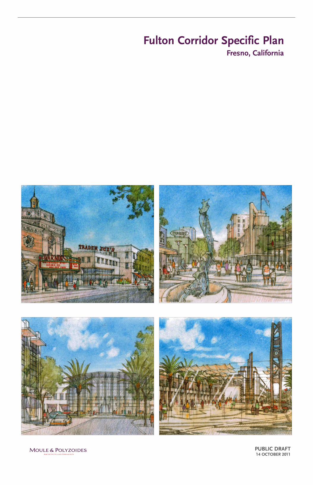
Fulton Corridor Specific Plan
PubliC DRAFT 14 oCTobER 2011
Fresno, California
Consultant Team
lEAD ConSulTAnT Moule & Polyzoides Architects and urbanistsStefanos Polyzoides, PrincipalJuan Gomez-Novy, Project ManagerJason ClaypoolScott Ford Orlando GonzalezXiaojian He Damon HerringThiago Valente
PlAnning PoliCy + CoDERaimi + Associates Matt Raimi, PrincipalTony Perez, Principal
uRbAn EConoMiCSStrategic Economics Dena Belzer, Principal in ChargeSujata SrivastavaSarah Graham
uRbAn RETAil PlAnninggibbs Planning group Robert Gibbs, Managing Principal
TRAnSPoRTATion/TRAFFiCFehr & Peers Ron Milam, Principal in ChargeJeff Clark, Principal
inTERMoDAl PlAnningnelson nygaard Jeffrey Tumlin, Principal in ChargePaul Jewel, Principal
SuSTAinAblE inFRASTRuCTuRESherwood Design Engineers Bry Sarté, Principal in Charge Eric Zickler, Project ManagerJohn LaysMike Amodeo
lAnDSCAPE ARChiTECTuREFong hart Schneider + Partners David Schneider, Principal in Charge
hiSToRiC RESouRCE AnAlySiShistoric Resources group Christy Johnson McAvoy, Principal in ChargePaul Travis, Senior Preservation Planner
CulTuRAl RESouRCE AnAlySiSCultural landscape Foundation Charles Birnbaum, President
EnviRonMEnTAl AnAlySiS & PlAnning/EiRimpact Sciences Tony Locacciato, Principal in ChargeAli Mir
Civil EnginEERSlars Andersen & Associates Daniel Zoldak, Principal in Charge
gEoEnviRonMEnTAl ConSulTingKrazan & Associates Art Farkas, Environmental Division Manager Dean L. Alexander, Principal Engineer
CulTuRAl RESouRCES ConSulTAnTgreenwood and Associates Roberta S. Greenwood, PartnerJohn Foster, Vice President
ChARRETTE viSuAliZingurban Advantage Steve Price, Principal in Charge
WEbSiTE DESignArrowpoint Design Christopher Ross
Client
City of Fresno2600 Fresno Street, Room 2156-02Fresno, CA 93721
MAyoRAshley Swearengin
CiTy CounCilBlong Xiong, Councilmember District 1Andreas Borgeas, Councilmember District 2Oliver Baines, Councilmember District 3 Cynthia Sterling, Councilmember District 3 (term ended 1/6/2011)Larry Westerlund, Councilmember District 4Sal Quintero, Councilmember District 5Mike Dages, Councilmember District 5 (term ended 1/6/2011)Lee Brand, Councilmember District 6Clint Olivier, Councilmember District 7Henry T Perea, Councilmember District 7 (term ended 12/2/2010)
CiTy MAnAgERMark Scott
CoMMuniTy ADviSoRy CoMMiTTEE
DEPARTMEnTAl WoRKing gRouPProject Team Craig Scharton, DirectorWilma Quan, Project ManagerElliott Balch Elaine Robles-McGraw
City of Fresno AirportsKevin Meikle, Airports Planning Manager, Assistant
Director of AviationDaniel Yrigollen, Airports Project Supervisor
budgetRenena Smith, Director
City AttorneyJohn Fox, Senior Deputy City Attorney
FinanceJoe Gray, ControllerKaren Bradley, Assistant ControllerPhil Hardcastle, Principal Accountant
FireByron Beagles, Fire Prevention Engineer
Fresno Area ExpressJohn Downs, Transit Planning Manager
information ServicesGary Watahira, Assistant Director, Information
Services Department
Parks After School Recreation & Community ServicesTony Hernandez
Planning & DevelopmentArnoldo Rodriguez, Planning ManagerBrian Leong, Building & Safety Services ManagerKevin Fabino, Planning ManagerKarana Hattersley-Drayton, Project ManagerClaudia Cazares, Housing & Community
Development Manager
Police DepartmentGregory Garner, Captain
Public utilitiesMartin Querin, Assistant Director, AdministrationBrock Buche, Supervising Professional EngineerJerry Schuber, Solid Waste Management Division
ManagerDoug Hecker, Supervising Engineering TechnicianSteve Hogg, Assistant Director, Water DivisionRobert Andersen, Assistant Director, Sewer and
Wastewater Division
Public WorksScott Mozier, Assistant Director / City EngineerDel Estabrook, Parking ManagerScott Krauter, Assistant DirectorScott Tyler, Traffic Engineering Manager Efren Banuelos, Assistant Director
Redevelopment AgencyMarlene Murphey, Executive DirectorLupe Perez, Project Manager
Fresno Metropolitan Flood Control DistrictJerry Lakeman, Chief EngineerWendell Lum, Master Plan Special Projects
Manager
Joyce AikenAlan L. AllenRosemarie AmaralDonavan ByrnJames J. ConnellRaul De AlbaMorgan DoizakiVictoria GonzalesEvan Hammer, Jr.
Patrick HammondJames HaronEric A. KalkowskiSaundra KingGary LanfrancoNancy MarquezRoger PalominoPolly ParentiTimothy Shulz
Maribel Vera-AnayaBrent WeinerAllysunn WilliamsNadar AliSuzanne Bertz-RosaBeth EckloffJan Minami

Table of Contents
ChAPTER 1introduction
1.1 Specific Plan Summary
1.2 Plan Area Definition
1.3 Plan Purpose
1.4 Plan Preparation Process
ChAPTER 2A vision for Downtown Fresno in 2035
2.1 Introduction
2.2 Community Values for Revitalization
2.3 Design Principles
ChAPTER 3Plan Framework and goals
3.1 Introduction
3.2 Downtown Districts
3.3 Development Capacity
3.4 Development Potential
ChAPTER 4The Fulton Mall
4.1 Pedestrian Malls in American Downtowns
4.2 History of The Fulton Mall
4.3 Existing Conditions
4.4 Choosing a Future
4.5 The Options
4.6 Studying “The Project”
4.7 Mariposa Plaza
ChAPTER 5Priority Development Projects
5.1 Introduction
5.2 Priority Development Projects
ChAPTER 6 building and Development
6.1 Introduction
6.2 Development Strategies
6.3 Development Framework
6.4 Land Use Designations, Overlays and Regulating Plan
ChAPTER 7 historic Preservation
7.1 Introduction
7.2 Preservation Strategies
7.3 Preservation Framework
ChAPTER 8 Public Realm
8.1 Introduction
8.2 Public Realm Strategies
8.3 Open Space Improvements
8.4 Streetscape Enhancements
ChAPTER 9 Transportation
9.1 Introduction
9.2 Transportation Strategies
9.3 Street Improvements
9.4 Parking Improvements
9.5 Transit Improvements
9.6 Bicycle Improvements
9.7 Railroad Crossing Improvements
9.8 High-Speed Train Improvements
ChAPTER 10 utilities
10.1 Introduction
10.2 Infrastructure Strategies
10.3 Domestic Water Infrastructure
10.4 Sewer Infrastructure
10:5 Recycled Water Infrastructure
10:6 Utility Synergies
10:7 Stormwater Infrastructure
10:8 Sustainable Infrastructure - General
ChAPTER 11 implementation
11.1 Introduction
11.2 Strategies for Implementing the Specific Plan
11.3 Funding and Financing Tools
11.4 Building and Development
11.5 Historic Resources
11.6 Public Realm
11.7 Transportation
11.8 Sustainability, Infrastructure, and Resources
APPEnDiX A Fulton Mall
page
1:1
1:4
1:6
1:10
2:1
2:1
2:6
3:1
3:2
3:22
3:24
4:2
4:3
4:4
4:7
4:8
4:16
4:18
5:1
5:2
6:1
6:2
6:4
6:10
page
7:1
7:6
7:7
8:1
8:2
8:3
8:16
9:1
9:2
9:3
9:9
9:15
9:18
9:20
9:22
10:1
10:2
10:3
10:5
10:6
10:7
10:8
10:14
11:1
11:3
11:4
11:8
11:10
11:12
11:20
11:34
A:1

THIS PAGE INTENTIONALLY LEFT BLANK
MAYOR ASHLEY SWEARENGIN
City of Fresno
2600 Fresno Street · Fresno, California 93721 · (559) 621-8000 · Fax (559) 621-7990 · www.fresno.gov
Dear Valley resident or Downtown Fresno investor:
If you want to see what our city and region are all about, you’ve come to the right place. Welcome toDowntown Fresno.
For decades, our downtown served as the gathering place for the entire central San Joaquin Valley.People would “go into town” from an hour away for everything they couldn’t find in smaller, outlyingcommunities. In Downtown Fresno they found their doctor, banker, lawyer, and dentist. They foundmerchandise in fancy stores that they couldn’t find anywhere else in the area. They found movies andplays and concerts to watch and enjoy.
And, they found each other. Young men and women came to Downtown to show off their cars, their
a wider variety of people than they could find in their home communities.
For Downtown, good fun was good business. As people converged here, so did their dollars. Thatallowed downtown businesses and the City to maintain the place as a vibrant destination.
But as we all know, it wasn’t to last. As with cities across our country, starting in the 1950s,Downtown Fresno began telling a different kind of story about our city and region. Fulton Street retailanchors started feeling the draw of suburban shopping centers being planned near new homes underconstruction farther and farther from the urban core.
Business leaders and the City reacted boldly by trying to give the public more of the suburbanexperience they seemed to crave. They hired a famous planner of shopping malls and a leading up andcoming landscape architect to install the nation’s second pedestrian mall on Fulton in 1964. Theyinvested heavily in sculptures, fountains, and other public art. They even recast the street grid andconstructed garages with thousands of parking stalls. Their singular goal was to replicate the suburbanshopping experience being built on bare dirt just beyond the edges of Fresno and cities acrossAmerica.
City leaders began to emulate the suburbs in less obvious ways as well. They adopted new land useplanning requirements for the growing city that, while written with the suburbs in mind, were forcedonto the urban area as well. The new standards did not distinguish between newer, suburban areas andestablished areas designed in earlier days to bring a mix of uses within walking distance of each other,in buildings old and new. With the wrong rules in place, every new building or street widening that
clothes, their hair, and their manners – both good and bad. They came to meet and date and dance with

VI
ChAPTER 1: inTRoDuCTion
City of Fresno
2600 Fresno Street · Fresno, California 93721 · (559) 621-8000 · Fax (559) 621-7990 · www.fresno.gov
tried to make downtown more like its suburban counterparts actually eroded the urban core, ratherthan revitalizing it.
Like the rapidly growing city, Downtown also became a less focused place. With the conception ofthe freeway triangle in 1957, the notion of downtown grew in size from a few blocks to hundreds ofacres. Projects over a mile apart from each other were considered helpful to the revitalization effort,even though there was no synergy or connectivity between them. Meanwhile at ground zero onFulton, the core of our main street was becoming a different kind of economic anchor, one that waspulling the rest of Downtown down with it.
Much of Downtown Fresno’s story of decline is common to cities across America. Yet over the last
Fresno, despite generations of urban decay.
to draw upon. We know the most successful downtowns direct investment and resources to a focusedarea. Through good urban planning and design, projects in proximity begin to support each other andcreate foot traffic. Shoppers, diners, and concert-goers can park once and spend hours exploring thebenefits that vibrant downtowns offer. As customers walk past storefronts, new businesses open totake advantage of the activity. Historic buildings add unique character, respecting the region’s pastwhile differentiating downtown from newer, less distinctive suburbs.
There is no reason these revitalization fundamentals will work differently in Fresno than they have sowell, time and again, in other places.
Our first step is this document: the Fulton Corridor Specific Plan. The Specific Plan and theaccompanying new Form-Based Code for development replace the outdated regulations of the City’s1960s-era zoning code with new rules that make it easier than ever to develop great projects based onthe best of our past. The new Specific Plan and Code replace the frustration of the stalwart firstinvestors with a new sense of momentum, built symbiotically from one project to another to another,
story of our community coming together, remembering its identity, and choosing to do what it takes toensure a vibrant future. It is the story of realizing we really can get the fundamentals right and makeDowntown Fresno a vibrant asset to our city and region once again.
Under the Fulton Corridor Specific Plan, there has never been a better time to invest in our urban corethan today. Welcome to Downtown Fresno.
Sincerely,
Ashley SwearenginMayor
two decades, many of those cities have been able to revitalize their urban centers — many, like
Now, it is Fresno’s turn to revitalize our downtown. Fortunately, we have many successful examples
as more and more people invest and develop with ease, as well as confidence.
Well over a century on, Downtown Fresno is still the place to see what our city and region are all about. Except today, more than just the story of our past, Downtown is the story of our future. It is the

FRESno FulTon CoRRiDoR SPECiFiC PlAn, CiTy oF FRESno, CAliFoRniA | PubliC DRAFT oCTobER 14, 2011 VII
ChAPTER 1: inTRoDuCTion
PREFACE
Downtown Fresno is where the city began. From its incorporation in 1885 and through the 1960’s, it was the commercial, business and cultural center of the Central Valley: A vibrant and compact place comprised of bustling sidewalks shaded by awnings, successful street level retail stores with offices above, convenient parking, and – until the 1930’s – an accessible streetcar system. A great number of historic pho-tographs describe the Downtown in this extraordinary traditional urban form.
After the Second World War, Fresno’s pattern of development, like that of most American cities, was radically altered. The passage of the G.I. Bill in 1944 enabled returning veterans to purchase homes and establish businesses. In addition, the Federal-Aid Highway Act of 1956, passed during the height of the Cold War, authorized and funded the construction of freeways across the entire United States. These freeways supported military and civil defense operations, facilitated interstate travel and commerce, and, perhaps unwittingly, encouraged the decen-tralization of America’s City Centers. Indeed, the automobile provided easy access to inexpensive land and made it no longer necessary to locate residential, commercial, and business uses in close proximity to one another. The completion of the Mayfair subdivision in 1947, north of the Plan Area, included Fresno’s first suburban shopping mall and ushered in an era of development at the suburban fringe. People began to move out of Fresno’s pre-World War II residential neighborhoods and scatter into the new, northern subdivisions. Businesses and important institutions, such as Fresno State University, followed, resulting in a slow decline of the Central Business District and its surrounding corridors.
The leaders of Fresno reacted swiftly to this emerging trend. In 1958, they invited the most famous urban planner of the period, Victor Gruen, to come to Fresno and to frame a vision and plan for modernizing the center of the city. The Gruen Plan was daring for its time. Yet, many of its prescriptions – supporting the building of freeways, pedestrianizing the entire commercial Downtown, encouraging street closures and one way conversions, promoting wholesale building demolition and super-block formation – proved ineffective and failed to revitalize Downtown. Indeed, as the below photo of Fulton Street in the late 1950’s shows, Downtown was not completely dead. Many stores still existed and competed for business – primarily because they were visible to pass-ing motorists. The elimination of automobiles from the Fulton Mall removed this flow of potential customers, arguably hastening the decline of the stores that lined its length and contributing to the chronic vacancy of its historic office buildings. In addition, the closure of Fulton Street, Merced Street, Mariposa Street, and Kern Street made Downtown more difficult to navigate.
The Gruen Plan declared the form of the historic Downtown obsolete, but the Modern Downtown it so passionately promoted did not emerge fast enough, or convincingly enough, to become visible or desirable to the market. For a couple of generations, the development field tipped decidedly in favor of massive suburban growth. Beginning in the 1960’s, new urban planning and “urban renewal” efforts became the norm, yet frequently did more harm than good to established downtowns and sur-rounding neighborhoods. The failure of these efforts – along with the inexpensive land, wide streets, new schools, and newly relocated retail-ers found at the city’s edge – lured Fresnans to the suburbs in droves. There many found they could live in new houses, move more freely, and exercise a greater range of working, retail, and entertainment choices.
Eventually, after many decades of this kind of development, the munici-pal government also became focused on servicing this kind of suburban growth. Demolition of historic buildings and large scale development that was not designed to fit with its surroundings began to occur Downtown. As a result, Downtown’s economy was deeply shaken and its traditional, walkable, human-scale, mixed-use urban form was put into question as it became characterized by high vacancy rates, low land values, a total absence of people once the work day ended, and concen-trated poverty in the surrounding neighborhoods. By 1990, Downtown Fresno, including the Fulton Mall, was in a state of physical, economic, and social free fall. According to a recent study, the Fulton Mall gener-ated about $365,969 in annual property and sales tax revenues in 2008. If the Mall were developed and built to its potential, the preparers of the study estimated that it could generate over $6 million annually in City revenues. Therefore, the Mall was contributing only 5.7 percent of its revenue generating potential in 2008.1
The great recession of 2008 exposed Fresno’s fiscal fragility. With no net source of revenue being generated by property and sales taxes in the center of the city, and Fresno’s city-wide finances weakened, major layoffs and drastic reductions in services resulted.
At this critical point in the city’s history, a revitalization of its Downtown is a matter of fiscal urgency. Many cities draw a significant portion of their revenues from an economically vibrant downtown. Will Fresno fol-low this path?
View of Fulton Street at Mariposa Street looking north (1959). Credit: Pop Laval Foundation
View of Fulton Street at Tulare Street(1936). Credit: Pop Laval Foundation
1 Market Profiles, “Economic Impact Study Listing of Fulton Mall on National Register of Historic Places,” September 2008.

VIII
ChAPTER 1: inTRoDuCTion
THIS PAGE INTENTIONALLY LEFT BLANK

FRESno FulTon CoRRiDoR SPECiFiC PlAn, CiTy oF FRESno, CAliFoRniA | PubliC DRAFT oCTobER 14, 2011 1:1
ChAPTER 1: inTRoDuCTion
ChAPTER 1: inTRoDuCTion
The Fulton Corridor Specific Plan is the community’s tool for guiding the future development of Downtown Fresno. It is both a visionary document that lays out the community’s long-term goals for the Plan Area, as well as an implementation plan for immediate and midterm actions needed to achieve the long-term vision. It provides detailed policies concerning a wide range of topics, including land use and development, historic resources, the public realm, transportation, and infrastructure. These policies provide the foundation for urban and economic growth, as well as the basis for the City to make the tough daily choices regarding growth, historic preservation, housing, transportation, the environment, community facilities, and community services.
The Specific Plan is used by the Mayor and Administration, the City Council, the Planning Commission, the Redevelopment Agency, and the Development and Resource Management (DARM) Department to guide decisions about the Plan Area’s future, to evaluate development proposals, and to make funding and budgetary decisions. It is used by City staff to direct their day-to-day activities, particularly those related to building and development, and the installation and maintenance of utilities. It is used by citizens and neighborhood groups to understand the City’s long-range plans and proposals for different parts of the City. Its policies apply to both public and private properties and initiatives and give Downtown businesses and developers certainty about how to invest in their properties and in development projects.
The Fulton Corridor Specific Plan contains the following chapters:
Chapter 1: introduction.
This Chapter begins with a description of the Plan Area, including its location and boundaries. This is followed by an explanation of the Plan’s purpose, including its relationship to other plans and documents. It ends with a summary of the process the City and the community went through to prepare this Specific Plan.
Chapter 2: A vision for Downtown Fresno in 2035.
This Chapter describes the overall vision, generated by input from Fresnans, for transforming Downtown into a vibrant regional destination. It begins with a vision statement which, in turn, is followed by ten community values for revitalization. It concludes with ten core design principles that are applied to each of Downtown’s unique districts.
1.1 SPECiFiC PlAn SuMMARy
Chapter 3: Plan Framework and goals.
This Chapter begins with a description of the existing conditions and vision for each of Downtown’s seven districts. This is followed by a description of how much development the market can support within the Plan Area. The chapter concludes with a description of what the Plan Area’s underutilized land – vacant parcels and surface parking lots – can support under the direction of the Downtown Development Code.
Chapter 4: The Fulton Mall.
This Chapter describes the existing conditions of the Fulton Mall, the history of the Mall, the historic significance of the Mall, the economic conditions needed for retail to prosper there, and alternative visions for its future.
Chapter 5: Priority Development Projects.
This Chapter describes top priority projects for both the private and public sectors, focused in relatively small areas that will generate the most immediate physical impact, and catalyze economic regeneration. These projects are listed according to first and second priorities.
Chapter 6: building and Development.
This Chapter describes goals and policies that enable and facilitate Downtown’s physical transformation and that ensure that this transformation occurs in a manner that preserves and regenerates Downtown’s unique sense of place.
Chapter 7: historic Preservation.
Every great downtown uses its history as an asset. In this vein, this Chapter includes goals and policies for preserving and reviving the unique history and culture of Downtown. This includes preserving existing buildings and places and ensuring that new development is compatible with the area’s historic assets.
Chapter 8: Public Realm.
This Chapter provides an overall vision for increasing Downtown’s public space and improving the streetscape. Topics include improving the landscape character of the Fulton Mall, improving the axis between City Hall and the High-Speed Train station, transforming Courthouse Park, regenerating and maintaining the urban forest, and increasing comfort to pedestrians through a variety of streetscape improvements.
Fresno’s historic office buildings and movie houses provide opportunities for attracting people Downtown.
The Fulton Mall as it exists in 2011.

1:2
ChAPTER 1: inTRoDuCTion
Chapter 9: Transportation.
This chapter outlines Downtown’s future multi-modal transportation network that accommodates private automobiles, transit, walking, and biking. Key topics include street reconfiguration, transit and bicycle networks, Park Once and street parking, and the basic design of the High-Speed Train station area.
Chapter 10: Sustainability, infrastructure, and Resources.
This chapter addresses a range of topics, including water use, energy use, sewer capacity, and the provision of infrastructure. In addition to providing basic services to support future and existing development within the Downtown, a forward-looking approach to these topics continues Fresno’s role as a statewide leader in conservation and resource management.
Chapter 11: implementation.
The Plan proposes a development strategy driven by private investors. Plan-wide policies focus on historic preservation, retail and employment, shared parking, the public realm, livable neighborhoods, civic initiatives, and specific plan-implementation initiatives such as fast-tracking desirable development. Private sector development will be driven by residential, retail, and commercial market demand, and by the attraction provided by public improvements, predictable entitlement processes, and Downtown’s unique and desirable character.
Chapters 6-10 provide goals and policies that provide direction and guidance for transformation, while Chapter 11 lists specific implementation projects and actions for implementing the goals and policies set forth within the previous chapters. These are defined in the gray box at right:
goals General direction-setters that present a long-term vision.
Policies Support the stated goals by mandating, encouraging, or permitting desired actions and are categorized as either discretionary or mandatory:
Discretionary Proposed courses of action that are encouraged and strongly recommended, according to the good judgment of all City staff and decision makers responsible for implementation of the Plan
MandatoryRequired by all users of this Plan and denoted by a ‘►’
implementationProjects and Actions
Discrete tasks, categorized as either projects or actions, that the City carries out in order to implement the vision of revitalizing Fresno’s core.
ProjectOne-time physical improvements to a part of the Plan Area (such as implementing traffic calming measures in a certain area).
ActionSpecific activities that will be completed by a certain time or at regular intervals (such as creating an ordinance or updating a master plan).
Farmers’ markets, like this one in the Cultural Arts District, provide access to locally grown fruits, vegetables, and nutritious foods.
Downtown with its pedestrian-oriented building fabric, serves as the retail, shopping, and entertainment center of Fresno.

FRESno FulTon CoRRiDoR SPECiFiC PlAn, CiTy oF FRESno, CAliFoRniA | PubliC DRAFT oCTobER 14, 2011 1:3
ChAPTER 1: inTRoDuCTion
KEy
Existing Buildings
KEy
Existing Buildings
Potential Development
Birds-eye view of Downtown as it could exist in 2035 as proposed by this Specific Plan. The final form and design of the HST alignments and stations statewide, as well as mitigation of the system’s identified environmental impacts, will be determined by the California High-Speed Rail Authority.
Birds-eye view of Downtown as it existed n 2010.
n
n

1:4
ChAPTER 1: inTRoDuCTion
A. PRoJECT loCATion AnD bounDARiES
Fresno is located in the heart of California’s San Joaquin Valley, approximately 190 miles southeast of San Francisco and 220 miles northwest of Los Angeles. The Valley is one the largest and most productive farming regions in the world. Fresno, the regional city for the central San Joaquin Valley, is also the gateway to Yosemite National Park, Sierra National Forest, Kings Canyon National Park, and Sequoia National Park. Regional access to Fresno from the north and south is provided by State Routes 99 and 41, from the west by State Route 180, and from the east by State Routes 168 and 180.
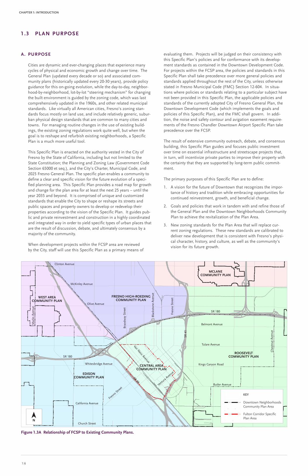
The Fulton Corridor Specific Plan (FCSP) Area is located within the southern portion of the City, as shown in Figure 1.2A, and is com-pletely surrounded by the Downtown Neighborhoods Community Plan Area, as shown in Figure 1.2b below.
The Specific Plan Area covers approximately 655 acres and is gener-ally bounded to the north by Divisadero Street, to the west by State Route 99, to the south by State Route 41, and to the east by N Street, O Street, and the alley between M and N Streets. The Plan Area is divided by the Union Pacific railroad right-of-way. See Figure 1.2C.
Figure 1.2b Specific Plan Area. This map shows the boundaries of the Downtown Neighborhoods Community Plan and Fulton Corridor Specific Plan.
Figure 1.2A location of Specific Plan within the City of Fresno and its Sphere of influence.
§̈¦180
180
H
MA
RK
S
CHURCH CHURCH CHURCH
CH
ANC
E
180
180DUDLEY
TULARE
G
MA
RK
S
MA
PLE
CE
DA
R
PALM
CHURCH
HU
GH
ES
R
WES
T
BUTLER
FRESNO
FIR
ST
CH
ESTN
UT
ELM
CALIFORNIA
KEARNEY
OR
AN
GE
NIELSEN
OLIVE
FRU
IT
EAST
TULARE
BELMONT
WHITES BRIDGE
BLA
CK
STO
NE
MA
RO
A
WA
LNU
T
MCKINLEY
§̈¦168
VENTURA
GOLDEN STATE
KINGS CANYON
CLINTON
SHIELDS
CH
ERR
Y
STANISLAUS
MIL
LBR
OO
K
HAZELWOOD
MA
RTI
N L
UTH
ER
KIN
G J
R
TULARE
§̈¦99
SHIELDS
CE
DA
R
§̈¦41
B
CHURCH
FRU
IT
CH
ESTN
UT
WEBER
JENSEN
MA
PLE
MCKINLEY
DIVISADERO
BELMONT
VENTURA
HU
GH
ES
WES
T
OLIVE
CLINTONFRE
SNO
JENSEN
CALIFORNIA
H
CHURCH
MAR
KS
CH
ESTN
UT
EAST
NIELSEN
WES
T
BUTLER
KINGS CANYON
BELMONT
WEBER
GEA
RH
ART
CALIFORNIA
LANE
CE
DA
R
G
HU
GH
ES
THO
RN
E
WEBER
THO
RN
E
CHURCH
CH
ESTN
UT
NIELSEN
KEARNEY
DENNETT
180
KEy
Downtown Neighborhoods Community Plan Area
Fulton Corridor Specific Plan Area
1.2 PlAn AREA DEFiniTion
n
§̈¦180
§̈¦168
§̈¦180
§̈¦99
§̈¦99 §̈¦41
§̈¦41
KEy
City of Fresno
Community Plan Area
Specific Plan Area
Sphere of Influence

FRESno FulTon CoRRiDoR SPECiFiC PlAn, CiTy oF FRESno, CAliFoRniA | PubliC DRAFT oCTobER 14, 2011 1:5
ChAPTER 1: inTRoDuCTion
G
HE
F
A
M
P
O
C
99
R
180
TULARE
FRESNO
BELMONT
VAN
NES
S
41
VENTURA
FIR
ST
FIFT
H
U
Q
B
KERN
EIG
HTH
L
IOWA
SIX
TH
EAST
-
S
PLATT
OR
AN
GE
KEARNEY
T
TUOLUMNE
BUTLER
CHINA
STANISLAUS
INYO
FULTON
MO
DO
C
PLU
MA
S
ILLINOIS
N
CALIFORNIA
TRIN
ITY
AB
BY
ALTA
FRONTAGE
IVY
PAR
K
AMADOR
SANTA
FE
BROADW
AY
MCKENZIE
EFFI
E
LEE
NIELSEN
HUNTINGTON
FRU
IT
MONO
CA
LAV
ERA
S
HA
ZEL
WO
OD
TEIL
MA
N
CLA
RK
MAYO
R
GEARY
POTTLE
DIA
NA
HAMILTON
FOU
RTH
GOLDEN
STATE
KERCKHOFF
PARALLEL
GLE
NN
WHITES BRIDGE
KLETTE
ELM
TOPEKA
THO
RN
E
EDEN
EL MONTE
DUNN
POP
LAR
PALM
NEVADA
BALCH/MONO
FRANKLIN
LOWE
FAGAN
A/B
MYERS
STROTHER
SAN
PA
BLO
OLEANDER
RO
SE
MA
RIP
OSA
MONO/VENTURA
VALE
RIA
GEA
RH
AR
T
POP
PY
BLA
CK
STO
NE
NAPA
IRWIN
NIN
TH
MA
RY
VERRUE
WHITE
FLORENCE
WATERM
AN
JON
ES
AN
GU
S
MONTECITO
CO
LLEG
E
AB
BY/
EFFI
E
BRALY
AN
NA
PEA
RL
EUN
ICE
ATCHISON
DEL
NO
CA
LLIS
CH
RAILROAD
ONEIL
DIA
NA
/EFF
IE
HO
LLY
WAY
TE
DWIGHT
SAR
AH
HEATON
BALCH/HUNTINGTON
ALTA/LOWE
GRANT
CH
ERR
Y
HAWES
WA
LNU
T
VALENCIA
LORENA
PAC
IFIC
FER
GER
LOS ANGELES
ORLEANS
THES
TA
STEP
HEN
S
LYELL
CLA
RK
/DIA
NA
SANBENIT
O
MARTIN
MA
UD
HUNTINGTON/KERCKHOFF
KERCKHOFF/PLATT
AIRPORT
YOSE
MIT
E
SEC
ON
D
WEBER
D
LOTU
S
TOWNSEND
LIBERTY/LOWE
FAIR
VIE
W
B/C
ECH
O
RA
ISIN
A
CHANDLER
GEN
EVA
MADISON
BALCH
PARKWAY
RO
OSE
VEL
T
PLATT/VERRUE
REV CHESTER RIGGINS
LILY
PLATT/TULARE
FRES
NO
/U
CHURCH
GLE
NN
/SA
NP
AB
LO
PIC
KFO
RD
SEV
ENTH
LIBERTY/LYELL
POP
LAR
/SA
NP
AB
LO
MERCED
LIBERTY
EL DORADO
COLLIN
S
GILBERT
PRIVATE
AR
THU
R
HU
MB
OLD
T
MADDY
CLA
RA
WOODWARD
TUPM
AN
CHANNING
CAPITOL
99/C
THIR
D
FULT
ON
/VA
NN
ESS
LEMON
WASHINGTONBLA
CK
STO
NE/
CA
LAV
ERA
S
OR
CH
AR
D
ARROYO
CO
LLEG
E/VA
NN
ESS
LYMAN
HEATON/ORLEANS
COBB
NIC
HO
LAS
SANTACLARA
MA
RIP
OSA
/U
CLA
RK
/VA
LER
IA
DIVISADERO
HO
ME
RUN
SNO
W
DONAHOO
THES
TA/V
ALE
RIA
HAMILTON/ORLEANS
DU
RA
NT
HEATON/TOWNSEND
WES
LEY
GRANT/MADISON
SACRAMENTO
ILLINOIS/IOWA
CA
LAV
ERA
S/G
LEN
N
KIRK
FER
GER
/PA
LM
MA
RTI
NLU
THER
KIN
GJR
BRALY/HAMILTON
HER
WA
LDT
LANE
FULT
ON
/YO
SEM
ITE
VOORMAN
KASHIAN
GRANT/WASHINGTON
WEL
LER
BRALY/WOODWARD
ILLINOIS/NEVADA
BO
ND
MONTEREY
BELMONT/WHITE
HO
WA
RD
BA
RD
ELL
MCKENZIE/WASHINGTON
MCKENZIE/NEVADA
SAN JOAQUIN
41/O
RC
HA
RD
IOWA/TULARE
FISH
ER
DIA
MO
ND
BR
OA
DW
AY/Y
OSE
MIT
EMILDREDA
FAR
RIS
TULI
P
CO
LLEG
E/P
AR
K
EIG
HTH
/OR
AN
GE
MAIN
ALTA/MONTECITO
MIL
LBRO
OK
WIL
SON
AU
GU
STA
GR
AC
E
BUTLER/TOWNSEND
KLONDIKE
BELMONT/MADISON
ECH
O/R
OO
SEV
ELT
FRES
NO
/HO
WA
RD
SMIT
H
EL MONTE/MONTECITO
AN
GU
S/D
IAM
ON
D
SPA
LDIN
G
DIA
MO
ND
/MA
RIP
OSA
THO
RN
E
-
FAGAN
LOTUS
SEC
ON
D
LORENA
O
SAN JOAQUIN
41
PLU
MA
S
SANTACLARA
CHANDLER
SANJO
AQUIN
NEVADA
MILDREDA
ECH
O
MONTEREY
41
FRU
IT
41
LYELL
41/O
RC
HA
RD
MARIP
OSA
GRANT/MADISON
CHINA
AN
NA
SEC
ON
D
PRIVATE
GLE
NN
LORENA
FLORENCE
MYERS
MERCED
41ATCHISON
ALTA
LORENA
FRONTAGE
PEA
RL
-
FLORENCE
WASHINGTON
SAR
AH
OR
CH
AR
D
DEL
NO
ORLEANS
WOODWARD
VOORMAN
BELMONT/WHITE
WOODWARD
FOU
RTH
HAMILTON
TEIL
MA
N
PAR
ALL
EL
LIBERTY/LYELL
LORENAPRIVATE
LOS ANGELES
BA
RD
ELL
C
CALIFORNIA
MARIPOSA
L
FRANKLIN
GRANT
WOODWARD
NIN
TH
CALIFORNIA
DIA
NA
MARIP
OSA
VOORMAN
BALCH
SEV
ENTH
GRANT
CLA
RA
FIFT
H
MILDREDA
NIN
TH
CH
ERR
Y
MONO
SEC
ON
D
INYO
PRIV
ATE
PRIVATE
CH
AN
NIN
G
GEARY
FRONTAGE
EL MONTE
FER
GER
SANBENITO
LORENA
LOWE
FLORENCE
ILLINOIS
LIBERTY/LOWE
EL DORADO
EL DORADO
N
PRIV
ATE
CALIFORNIA
CH
AN
NIN
G
FLORENCE
VOORMAN
180
MCKENZIE
180
LORENA
AR
THU
R
BRALY
PRIVATE
LILY
MERCED
LORENA
99
CALIFORNIA
FRONTAGE
41/O
RC
HA
RD
CLA
RK
BELMONT/WHITE
NAPA
N
WEL
LER
FOU
RTH
NEVADA
FAGAN
DIVISADERO
GRANT
SEV
ENTH
F
L
MARIP
OSA
PRIVATE
SANBENITO
ATCHISON
-
CO
LLEG
E
EL DORADO
TEIL
MA
N
MERCED
P
PRIVATE
YOSE
MIT
E
BROADW
AY
HEATON
CH
ERR
Y
LEMON
F
WEBER
PRIVATE
PAR
ALL
EL
INYO
LORENA
GOLDEN
STATE
WOODWARD
L
ILLINOIS
DU
RA
NT
LORENA
FULTON
/VANN
ESS
VALENCIA
BRALY
FIFT
H
FLORENCE
MONO
MARIP
OSA
MADISON
EIG
HTH
KERN
NIN
TH
CH
ERR
Y
FIFT
H
DEL
NO
TOWNSEND
MONO
HAWES
SANJO
AQUIN
DIVISADERO
ECH
O
AN
NA
DIA
MO
ND
ATCHISON
TOWNSEND
FULTON
SAN BENITO
KERCKHOFF/PLATT
AR
THU
R
FOU
RTH
FRU
IT
E
CH
AN
NIN
G
AMADOR
THIR
DTH
IRD
MONO
FRANKLIN
PLU
MA
S
INYO
MARIPOSA
FLORENCE
FRANKLIN
NIN
TH
AR
THU
R
B
-
MONO
GRANT
ATCHISON
COLLIN
S
BROADW
AY
CALAVERAS
LORENA
EDEN
WHITE
RO
OSE
VEL
T
FULTON
LIBERTY
SANTACLARA
legend
Fulton Corridor Specific Plan Bdry
Specific Plan Aerial
´ 0 500 1,000 1,500 2,000250 Feet
City of Fresno, CaliforniaFulton Corridor Specific Plan andDowntown Neighborhoods Community Plan17 August, 2010
Figure 1.2C Specific Plan Area
The Downtown skyline.
n
1:6
ChAPTER 1: inTRoDuCTion
1.3 PlAn PuRPoSE
Figure 1.3A Relationship of FCSP to Existing Community Plans.
A. PuRPoSE
Cities are dynamic and ever-changing places that experience many cycles of physical and economic growth and change over time. The General Plan (updated every decade or so) and associated com-munity plans (historically updated every 20-30 years), provide policy guidance for this on-going evolution, while the day-to-day, neighbor-hood-by-neighborhood, lot-by-lot “steering mechanism” for changing the built environment is guided by the zoning code, which was last comprehensively updated in the 1960s, and other related municipal standards. Like virtually all American cities, Fresno’s zoning stan-dards focus mostly on land use, and include relatively generic, subur-ban physical design standards that are common to many cities and towns. For managing routine changes in the use of existing build-ings, the existing zoning regulations work quite well, but when the goal is to reshape and refurbish existing neighborhoods, a Specific Plan is a much more useful tool.
This Specific Plan is enacted on the authority vested in the City of Fresno by the State of California, including but not limited to the State Constitution; the Planning and Zoning Law (Government Code Section 65000 et seq.), and the City’s Charter, Municipal Code, and 2025 Fresno General Plan. The specific plan enables a community to define a clear and specific vision for the future evolution of a speci-fied planning area. This Specific Plan provides a road map for growth and change for the plan area for at least the next 25 years – until the year 2035 and beyond. It is comprised of unique and customized standards that enable the City to shape or reshape its streets and public spaces and property owners to develop or redevelop their properties according to the vision of the Specific Plan. It guides pub-lic and private reinvestment and construction in a highly coordinated and integrated way in order to yield specific types of urban places that are the result of discussion, debate, and ultimately consensus by a majority of the community.
When development projects within the FCSP area are reviewed by the City, staff will use this Specific Plan as a primary means of
evaluating them. Projects will be judged on their consistency with this Specific Plan’s policies and for conformance with its develop-ment standards as contained in the Downtown Development Code. For projects within the FCSP area, the policies and standards in this Specific Plan shall take precedence over more general policies and standards applied throughout the rest of the City, unless otherwise stated in Fresno Municipal Code (FMC) Section 12-604. In situa-tions where policies or standards relating to a particular subject have not been provided in this Specific Plan, the applicable policies and standards of the currently adopted City of Fresno General Plan, the Downtown Development Code (which implements the goals and policies of this Specific Plan), and the FMC shall govern. In addi-tion, the noise and safety contour and avigation easement require-ments of the Fresno Chandler Downtown Airport Specific Plan take precedence over the FCSP.
The result of extensive community outreach, debate, and consensus building, this Specific Plan guides and focuses public investment over time on essential infrastructure and streetscape projects that, in turn, will incentivize private parties to improve their property with the certainty that they are supported by long-term public commit-ment.
The primary purposes of this Specific Plan are to define:
1. A vision for the future of Downtown that recognizes the impor-tance of history and tradition while embracing opportunities for continued reinvestment, growth, and beneficial change.
2. Goals and policies that work in tandem with and refine those of the General Plan and the Downtown Neighborhoods Community Plan to achieve the revitalization of the Plan Area.
3. New zoning standards for the Plan Area that will replace cur-rent zoning regulations. These new standards are calibrated to deliver new development that is consistent with Fresno’s physi-cal character, history, and culture, as well as the community’s vision for its future growth.
Community Plan AreasCity of Fresno, CaliforniaFulton Corridor Specific Plan andDowntown Neighborhoods Community Plan10 May, 2010
Fresn
o Street
Ventu
ra Ave
nue
Tulare Avenue
Kings Canyon Road
Butler Avenue
California Avenue
Church Street
Whitesbridge Avenue
Clinton Avenue
McKinley Avenue
Olive Avenue
Belmont Avenue
SR 180
SR 4
1
SR 180
SR 99
Bla
ckst
one
Ave
nue
Che
stnu
t A
venu
e
Mar
ks A
venu
e
Fres
no S
tree
t
Bra
odw
ay S
tree
t
n
FRESno high-RoEDing CoMMuniTy PlAn
WEST AREACoMMuniTy PlAn
EDiSonCoMMuniTy PlAn
CEnTRAl AREACoMMuniTy PlAn
RooSEvElTCoMMuniTy PlAn
MClAnE CoMMuniTy PlAn
Van Ness Avenue
KEy
Downtown Neighborhoods Community Plan Area
Fulton Corridor Specific Plan Area

FRESno FulTon CoRRiDoR SPECiFiC PlAn, CiTy oF FRESno, CAliFoRniA | PubliC DRAFT oCTobER 14, 2011 1:7
ChAPTER 1: inTRoDuCTion
4. The implementation strategy for transforming the Plan Area’s streets, infrastructure, parks, and other public spaces.
The above purposes provide private property owners with a clear understanding of the future context within which they are investing and reinvesting in their properties.
b. RElATionShiP oF ThiS SPECiFiC PlAn To oThER PlAnS AnD DoCuMEnTS
1. 2025 Fresno general Plan. The 2025 Fresno General Plan is the City’s primary policy planning document. Through its nine elements, the General Plan provides the framework for the management and utilization of the City’s physical, economic, and human resources. Each element contains goals, policies, and implementation measures that guide development within the City. The FCSP is designed to meet the goals established in the General Plan by providing a framework for future develop-ment within the Planning Area. The Specific Plan provides direct linkage between the City’s General Plan and detailed plans for development, and will direct the character and arrangement of future development and land uses within the Specific Plan Area, including:
• Location and sizing of infrastructure;
• Phasing of development and thresholds of development;
• Financing methods of public improvements; and
• In conjunction with the Downtown Development Code, establishing development standards.
The FCSP implements a variety of goals and policies in the exist-ing 2025 General Plan including:
• Enhancing the quality of life for the citizens of Fresno;
• Planning for the projected population within Fresno’s urban boundary in a manner that respects physical, envi-ronmental, fiscal, economic, and social issues;
• Preserving and revitalizing Fresno’s neighborhoods, its downtown, and its historic resources;
• Promoting a partnership among citizens, industry, and government which fosters well-planned and efficiently processed development;
• Supporting growth in accordance with the Ahwahnee Principles;
• Coordinating land uses and circulation systems to pro-mote a viable and integrated multi-modal transportation network;
• Managing growth to balance Fresno’s urban form while providing an adequate public service delivery system, which is fairly and equitably financed;
• Providing affordable housing;
• Providing a mix of land uses and amenities to foster com-munity identity and reduce travel;
• Providing quality open space, park, and recreational facili-ties and programs to support the projected population;
• Protecting, preserving, and enhancing significant biologi-cal, archaeological, and paleontological resources as well as critical natural resources, including air, water, and agri-cultural soils;
• Developing urban design strategies that improve Fresno’s visual image and enhance its form and function;
• Planning for a healthy business and diversified employ-ment environment, and providing adequate timely services to ensure Fresno is competitive in the marketplace;
• Protecting and improving public health and safety; and
• Recognizing, respecting, and planning for Fresno’s cul-tural, social, and ethnic diversity.
Figure 1.3b Relationship of FCSP to Existing Specific Plans.
Specific Plan AreasCity of Fresno, CaliforniaFulton Corridor Specific Plan andDowntown Neighborhoods Community Plan10 May, 2010
Fresn
o Street
Ventu
ra Ave
nue
Tulare Avenue
Kings Canyon Road
Butler Avenue
California Avenue
Church Avenue
Whitesbridge Avenue
Van Ness Avenue
Clinton Avenue
McKinley Avenue
Olive Avenue
Belmont Avenue
SR 180
SR 4
1
SR 180
SR 99
Bla
ckst
one
Ave
nue
Che
stnu
t A
venu
e
Mar
ks A
venu
e
Fres
no S
tree
t
Bra
odw
ay S
tree
t
n
FRESno ChAnDlER DoWnToWn AiRPoRT
SPECiFiC PlAn
ToWER DiSTRiCTSPECiFiC PlAn
yoSEMiTE SChool AREASPECiFiC PlAn
FRESno yoSEMiTE inT'l AiRPoRTSPECiFiC PlAn
buTTon/WilloWSPECiFiC PlAn
FulTon/loWEllSPECiFiC PlAn
KEy
Downtown Neighborhoods Community Plan Area
Fulton Corridor Specific Plan Area

1:8
ChAPTER 1: inTRoDuCTion
Table 1.3A Residential Population PotentialFCSP (Persons) DnCP (Persons) FCSP + DnCP (Persons)
Existing Population 1 3,877 66,344 70,221
New Population
New Construction 2 11,958 15,268 27,225
Existing Usable Space 2 1,635 n/a 1,635
Total Residential Population increase 13,593 15,268 28,860
Total Residential Population 17,470 81,612 99,0811 Source: Claritas, Inc.; American Community Survey 2006-2008; Strategic Economics 2010.32 Assumes 4.1 persons per household for the DNCP and 1.9 persons per household for the FCSP. The City-wide average for persons per household is 3.0. Source: Claritas, Inc.;
American Community Survey 2006-2008; Strategic Economics 2010. The DNCP is composed primarily of large families, while the FCSP is home to a much larger proportion of single person households.
Table 1.3b general Plan Allowed Population increase by Existing Community Plan Area
Existing Community Plan
Allowed Population increase (Persons)Population Within Proposed DnCP/FCSP
boundary (Persons)
Within Each Existing Community Plan
boundary 1
Within Proposed DnCP / FCSP boundary 1 year 2000 3 year 2035 4
Central Area 12,845 12,845 14,927 27,772
Edison 43,286 7,657 12,356 20,013
Roosevelt 39,036 5,809 35,598 41,407
West Area 73,913 5,447 4,754 10,201
Total 169,080 31,758 67,635 99,3931 Per 2025 Fresno General Plan Table 1 (Population Projections by Community Plan Area).2 Derived by determining the total population projected within the existing Community Plan areas (Central, Edison, Roosevelt, and West) and calculating the percentage that
corresponds to the area that falls within the FCSP and DNCP Plan boundaries. For example, it was calculated that 14.88% of the Roosevelt Community Plan area is within the Downtown Neighborhoods Community Plan boundary. The total allowed residential population within the Roosevelt Community Plan area is 39,036, thus 5,809 people (14.88% of the total Roosevelt Community Plan population) were included within the Downtown Neighborhoods Community Plan boundary. Percentage of existing community plan areas within proposed DNCP/FCSP boundary are: Central Area: 100.00%, Edison: 17.69%, Roosevelt: 14.88%, West Area: 7.37%.
3 Source: 2000 Census. The 2000 Census was used as the basis for the 2025 General Plan growth projections.4 Derived by adding together the year 2000 population and the allowed 2025 General Plan population increase for each existing plan area within the FCSP and DNCP boundaries.
1.3 PlAn PuRPoSE (Cont inued)
These goals are made tangible and ready to implement through the FCSP’s goals and policies that address five principal topics:
• Building and Development (including Urban Form and Land Use);
• Historic Preservation;
• Public Realm;
• Transportation; and
• Utilities Infrastructure.
By establishing policies and standards for the plan area, the FCSP is a valuable tool for implementing the General Plan at a site-specific level, as well as providing for orderly development within the planning area. The FCSP identifies such actions on the basis of being near-, mid-, or long-term priorities based on the community’s vision.
2. Downtown neighborhoods Community Plan. The Downtown Neighborhoods Community Plan (DNCP) is a highly articulated and informed extension of Fresno’s General Plan. It contains within its boundaries the FCSP Plan Area and provides policy direction for the FCSP Plan Area and the neighborhoods that surround it, as shown in Figure 1.2b (Specific Plan Area). The General Plan’s direction to generate activity centers and focus reinvestment in the center of the City is made tangible and ready to implement through the DNCP’s goals, policies, and actions. The FCSP further refines these goals, policies, and actions into specific projects, including their time frames, opinions of prob-able cost, and funding sources.
3. Existing Specific and Community Plans. The FCSP boundary overlaps portions of the pre-existing Central Area Community Plan (CACP), as shown in Figure 1.3A and the pre-existing Fulton Lowell Specific Plan (FLSP) as shown in Figure 1.3b. In addi-tion, the DNCP boundary completely overlaps both the CACP and FLSP boundaries. Accordingly, both the CACP and FLSP will be repealed and the provisions of the FCSP and the accompany-ing DNCP will completely replace the regulations of the CACP and the FLSP. The FCSP boundary also overlaps portions of the pre-existing Fresno Chandler Downtown Airport Specific Plan (FCDASP), as shown in Figure 1.3b. The FCSP continues to be subject to the noise contour and hazard zone information that is described in the FCDASP, and together with the DNCP, provides a vision and policies for the development of the applicable plan areas over time, including the portions of those areas included in the FCDASP.
As part of the preparation of this Specific Plan, the goals, poli-cies, and actions of the CACP and FLSP were evaluated in rela-tionship to the vision of the FCSP. Those that were supportive of the vision were included in the FCSP, while those that were con-trary to the vision were excluded. As a result, the goals, policies, and actions of this FCSP nullify and replace the goals, policies, and actions of these earlier plans.
In this Plan, goals, policies, or actions that are borrowed from the CACP and FLSP are followed in parenthesis by the preexisting plan initials and the goal, policy, or action num-ber of the respective plan. For example FCSP Policy 4-6-8 is Fulton/Lowell Specific Plan Policy 10-2 and is noted at the end of the FCSP policy as follows: “(FLSP Policy 10-2).” In some cases the original CACP or FLSP goal, policy, or action has been modified and the phrase “modified 2011” is added to the end of the goal, policy, or action. For instance, FCSP Policy 4-3-5 is a modified version of FLSP Policy 2-3 and is accordingly labeled “(FLSP Policy 2-3, modified 2011).”
In this Plan, goals, policies, or actions that are borrowed from the CACP and FLSP are followed in parenthesis by the preexisting plan initials and the goal, policy, or action number of the respective plan. For example FCSP Policy 4-6-8 is Fulton/Lowell Specific Plan Policy 10-2 and is noted at the end of the FCSP policy as follows: “(FLSP Policy 10-2).” In some cases the original CACP or FLSP goal, policy, or action has been modified and the phrase “modi-fied 2011” is added to the end of the goal, policy, or action. For instance, FCSP Policy 4-3-5 is a modi-fied version of FLSP Policy 2-3 and is accordingly labeled “(FLSP Policy 2-3, modified 2011).”

FRESno FulTon CoRRiDoR SPECiFiC PlAn, CiTy oF FRESno, CAliFoRniA | PubliC DRAFT oCTobER 14, 2011 1:9
ChAPTER 1: inTRoDuCTion
4. Population in Relation to general Plan and Existing Community Plans. This Plan anticipates that by the year 2035, the residential population of the FCSP area could increase by as many as 13,593 people to a total of 17,470 residents (See Table 1.3A, Residential Population Potential). Combined with the anticipated population of the surrounding neighborhoods, the total population of the DNCP and the FCSP is anticipated to increase by 28,860 people to a total population of 99,081 residents. These population potentials are within the limits established by the 2025 Fresno General Plan.
Note, however, that the General Plan allocates population by existing Community Plan areas. Table 1.3b (General Plan Allowed Population Increase by Existing Community Plan Area) shows the population increase allowed by the 2025 General Plan within each existing community plan area; the allowed popula-tion increase within the portion of each existing community plan that overlaps the DNCP Plan area; the actual population within the portion of each existing community plan that overlaps the DNCP Plan area in the year 2000 (per the 2000 Census); and the total expected population within the portion of each existing community plan that overlaps the DNCP Plan area in the year 2035. As Table 1.3b shows, the anticipated year 2035 popula-tion within the portions of the Edison, Roosevelt, and West Area community plans that overlap the DNCP is within the limits set by the 2025 General Plan. Note, however, that the CACP permits only 12,845 additional residents, but the DNCP proposes to allow as many as 14,927 additional residents within the previous CACP area. This increase is based upon the DNCP’s – and the accompanying FCSP’s – goals of generating a vibrant, mixed-use Downtown by introducing the maximum number of residents within the heart of Downtown, i.e., within the FCSP Plan area. To achieve this end, the DNCP applies the aggregate allowed residential population increase for each portion of the existing Community Plan areas to the entire combined DNCP boundary as shown in Table 1.3A (Residential Population Potential).
5. Downtown Development Code (Chapter 12.5 of the Fresno Municipal Code). This chapter of the Fresno Municipal Code addresses the 655-acre FCSP Plan Area as well as the surround-ing DNCP Plan Area. The Downtown Development Code is a Form Based Code that contains standards and requirements for development and land use activity within the FCSP Plan Area. It enables the variety of intended outcomes described in the Project Vision and is applied to all property within the FCSP’s boundaries. In addition, the Downtown Development Code identifies the specific provisions of Fresno’s Municipal Code that are being replaced or superseded by particular sections of the Downtown Development Code.
6. Merger no. 1 Redevelopment Plans. The Merger No. 1 Project consists of nine Redevelopment Project Areas. The FCSP bound-ary overlaps eight of the nine Redevelopment Project Areas (Central Business District, Chinatown Expanded, Convention Center, Fulton, Jefferson, Mariposa, South Van Ness, West Fresno I, and West Fresno II), as shown in Figure 1.3C. Each project area has its own separate Redevelopment Plan, with separate time and financial limits. The nine Project Areas are linked financially as “merged” Project Areas where tax increment funds generated in a particular Project Area can be spent in other Project Areas. None of the nine constituent redevelop-ment plans in the Merger No. 1 Project contain any land use, zoning, property development, or circulation requirements or regulations. Accordingly, land use and development standards for all projects within the nine Redevelopment Project areas are subject to this Fulton Corridor Specific Plan and the accompany-ing Downtown Development Code.
7. bicycle, Pedestrian, and Trails Master Plan. The Bicycle, Pedestrian, and Trails Master Plan (BMP) guides and influences bikeway policies, programs, and development standards to make bicycling in the City safer, comfortable, convenient, and enjoyable for all bicyclists. The goals, policies and actions of the FCSP are completely coordinated, aligned, and incorporated with those of the BMP pursuant to City Council direction set forth in City Council Resolution No. 2010-237.
Figure 1.3C Relationship of FCSP to Merger no. 1 Multi-Project Plan.
n Specific Plan Area

1:10
ChAPTER 1: inTRoDuCTion
Mayor Swearengin kicks-off the Design workshop by summarizing the community’s vision for the Downtown. Credit: Ryan C. Jones.
Community members review and discuss the various Fulton Mall options during the Fulton Corridor Design Workshop. Credit: Ryan C. Jones.
1.4 PlAn PREPARATion PRoCESS
The FCSP is the result of an intense public process which involved resi-dents, business owners, and property owners of the Fulton Corridor area in a series of public meetings and a six-day, open, participatory Design Workshop. The evolution of this plan was based on extensive commu-nity input throughout all phases of planning, including: Initial Outreach and Discovery, the Design Workshop, and Follow-up Outreach.
February - September 2010
initial outreach and Discovery. The Initial Outreach and Discovery phase consisted of an extensive existing conditions analysis, interviews with a broad range of interested stakeholders (municipal officials, devel-opers, business owners, and community members), and input from the public during three Fulton Corridor Specific Plan Community Advisory Committee (Committee) meetings.
During the March 9, 2010 Committee meeting, the consultant team outlined the upcoming process and described the place-based approach to revitalization that drives this Plan, including the principles of a Form Based Code. The Committee and public also shared their thoughts regarding priorities, issues, and concerns for the Fulton Corridor Specific Plan area.
During the April 20, 2010 Committee meeting, the consultant team presented the findings of its analysis of the planning issues involved, including the preliminary results of the site analysis, a summary of the input received in the departmental and stakeholder interviews, and a description of emerging development opportunities, constraints, and design themes. In addition, various consultant team members presented their initial findings on a variety of topics including the Public Realm (streets and open spaces), Transportation, Historic Resources, Infrastructure (water, sewer, storm drainage), and Economic Development.
During the June 8, 2010 Committee meeting, the public and the consul-tant team commented on the work that was produced at the Downtown Neighborhoods Community Plan Design Workshop and provided suggestions and recommendations for what policies and standards they would like incorporated in the Draft Downtown Neighborhoods Community Plan and the Draft Fulton Corridor Specific Plan.
During the September 14, 2010 Committee meeting, the Committee, the City, and the project team began exploring alternative ways of revi-talizing the Fulton Mall. The Initial Outreach and Discovery phase was brought to a close during two Pre-Design Workshop presentations, one each to the Planning Commission and City Council, in which the consul-tant team presented its discovery findings.
September 25 - october 2, 2010
Design Workshop. Building upon the input and findings of the Initial Outreach and Discovery phase, the Design Workshop brought the proj-ect team to Fresno and allowed focused interaction with all interested parties, including community groups and individual citizens, for seven intensive days of urban policy generation and design. The Design Workshop was interactive with recommendations on each of the design components (Public Realm, Transportation, Infrastructure, Form-Based Zoning Code) being developed simultaneously. Intended to maximize public input, the Design Workshop began with a Visioning Workshop, continued with evening and lunchtime presentations throughout the week, and finished with a final review.
• visioning Workshop (Day 1). On the morning of Saturday, September 25, 2010 the City and project team kicked-off the Design Workshop with a public meeting, facilitated by Travis Sheridan, in which the community developed a transformative vision for the future of Downtown: A vibrant destination at the core of Fresno and the central San Joaquin valley that is built on commerce and culture, connects our community, is authentic to our past, and provides opportunities for the future. Approximately 150 people attended the meeting and agreed upon the vision for Downtown which is summarized and expanded upon in Chapter 2 of this Specific Plan.
• Evening Presentations (Days 2-5). On the evening of Monday, September 27, 2010 (Day 2) the consultant team presented the existing conditions of the Fulton Mall’s (Mall) various elements (landscape, paving, fountains, artwork), the history of the Mall, the historic significance of the Mall, the economic conditions needed for retail to prosper there, and alternative visions for its future, ranging from doing nothing different, to restoring the Mall, to introducing a traditional street, to keeping some portions pedestrian-only while allowing vehicular traffic on other portions. Workshop participants, comprised of approximately 400 commu-nity members, expressed their likes and dislikes about each option, and provided more than 1,300 written comments on the merits of the various Mall alternatives.
The remainder of the Design Workshop focused on Downtown and its various districts. On Days 3 and 5 (September 28 and 30), the design team presented the development strategy for each of these districts: the Central Business District (CBD), the Cultural Arts District, the Civic Center, the South Stadium District, Chinatown, Armenian Town/Convention Center, and Divisadero

FRESno FulTon CoRRiDoR SPECiFiC PlAn, CiTy oF FRESno, CAliFoRniA | PubliC DRAFT oCTobER 14, 2011 1:11
ChAPTER 1: inTRoDuCTion
Workshop to the community. In addition, the City and project team presented the various Fulton Mall alternatives – including two new ones that were generated in response to comments that were presented at the Design Workshop – as well as the advantages, disadvantages, and proba-ble construction and maintenance costs of each. City staff also provided an overview of the Mall’s current physical conditions.
After substantial discourse and considerable input from the public, the Community Advisory Committee selected from among the ten initial Fulton Mall alternatives, recommending three for further study in the planning process. These alternatives, [will be] studied by the Environmental Impact Report, and are described in Chapter 4 of this Specific Plan.
On October 14, 2011, the City released the Public Draft of the Fulton Corridor Specific Plan for a 30-day public comment period. During this period, the City Manager [will] initiate the Plan prior to the kick-off of the Environmental Impact Report/Environmental Impact Statement. In addition, during this period, the Committee [will] convene four public workshops in order to provide the Committee and the public an opportu-nity to voice their opinion regarding the nature and recommendations of the Plan. Additional opportunities for public comment [will be] provided during an October 19, 2011 Planning Commission Workshop and an October 20, 2011 City Council Workshop.
Fall 2011- Summer 2012
Environmental impact Report (EiR). This phase is devoted to the gen-eration of the Environmental Impact Report (EIR) and Environmental Impact Statement (EIS) in order to address the requirements of the California Environmental Quality Act (CEQA) and the National Environmental Protection Act (NEPA). The EIR/EIS evaluates the poten-tial environmental impacts of the FCSP, the DNCP, and the Downtown Development Code. The Notice of Preparation is scheduled to occur in Winter 2011 with the public draft EIR/EIS ready for review in Spring 2011.
Fall 2012
Plan Adoption. This phase is devoted to navigating the final Specific Plan and EIR/EIS through the public hearing and adoption process and is comprised of a series of workshops and hearings with the Committee, the Planning Commission, the Historic Preservation Commission, and the City Council. The final product is an adopted Specific Plan and EIR/EIS. The Adoption process is scheduled to begin in Fall 2012 with final adoption of the Fulton Corridor Specific Plan occurring in late Fall 2012.
Triangle. See Figure 3.2A on page 3:3. During breakout sessions, community members discussed a variety of topics, including what they believed should be points of initial public and private investment and change, and what type of development is appropri-ate in each district. On Day 4 (September 29), the project team presented open space, landscape, and transportation strategies for Downtown – including incorporating the High-Speed Train station.
• lunchtime Presentations (Days 2-6). During the noon lunchtime hour, experts on the project team described the theory and practice of each of their disciplines and how it applies to Downtown Fresno: On Day 2, Historic Resources Group provided a brief history of Fresno, the City’s legislative framework for preserving historical assets, and a summary of the team’s reconnaissance findings. On Day 3, Strategic Economics discussed the economics of jobs, hous-ing, and business, presented the anticipated demand for each over the next 25 years, and proposed steps for revitalizing Downtown. On Day 4, Nelson\Nygaard and Fehr & Peers presented trans-portation-related city-building strategies, including creating a safe walking and biking environment, managing parking, making the right transit investments at the right time, and planning for the High-Speed Train. On Day 5, Fong Hart Schneider described how the elements of the Public Realm (Streets and Open Spaces) can generate a more vital Downtown through the introduction of street trees, street furniture, and activated open spaces. On Day 6, Raimi + Associates described the basics of Form Based Codes, comparing them to conventional zoning codes, and describing the structure of a potential new development code for the DNCP and FCSP Plan areas.
• Final Review (Day 7). On the last day of the Design Workshop (October 2), the project team presented development strategies and design interventions that had been identified, with commu-nity input, over the course of the previous week. Specific topics included economics, infrastructure, historic resources, transporta-tion, landscaping and open space strategies, as well as the form of buildings appropriate to each of Downtown’s districts. The morn-ing meeting concluded with a panel discussion led by City Manager Mark Scott in which attendees posed questions to members of the project team as well as to City staff.
october 2010 - April 2011
Follow-up outreach. The Follow-up Outreach phase began with a Community Advisory Committee meeting on October 19, 2010, in which the City and project team presented the results of the Fulton Mall Design
During the Design Workshop, approximately 400 community members expressed their likes and dislikes about each Fulton Mall option. Credit: Ryan C. Jones
1:12
ChAPTER 1: inTRoDuCTion
THIS PAGE INTENTIONALLY LEFT BLANK