full-text pdf - a science of cities
TRANSCRIPT

TPR, 78 (2) 2007
Michael Batty
Model cities*
Michael Batty is Bartlett Professor of Planning at University College London: Centre for Advanced Spatial Analysis, 1–19 Torrington Place, London WC1E 6BT; [email protected]
* This paper was fi rst delivered as the tenth Abercrombie lecture at the Department of Civic Design, University of Liverpool, on 16 May 2006.
The term ‘model’ is now central to our thinking about how we understand and design cities. We suggest
a variety of ways in which we use ‘models’, linking these ideas to Abercrombie’s exposition of Town and
Country Planning which represented the state of the art fi fty years ago. Here we focus on using models
as physical representations of the city, tracing the development of symbolic models where the focus is on
simulating how function generates form, to iconic models where the focus is on representing the geometry
of form in both two and three dimensions. Our quest is to show how digital representation enables us
to merge and manipulate form into function and vice versa, linking traditional architectural representa-
tion to patterns of land use and movement. Mathematics holds the key to simulation of many kinds and
computers now enable us to move effortlessly from the material world of atoms to the ethereal world of
bits and back. These new tools also provide us with powerful ways of showing how the real is able to
morph into the ideal and vice versa. We argue that this digital world which parallels the material, now
gives us unprecedented power to understand and explore cities in ways that Abercrombie could only
speculate upon, and we conclude by anticipating how we might respond to the new challenges posed
by unlimited access to these virtual worlds.
‘And yet in my mind I have constructed a model city from which all others can be deduced,’ Kublai said. ‘It contains everything corresponding to the norm. Since the cities that exist diverge in varying degree from the norm, I need only foresee the excep-tions to the norm and calculate the most probable combinations’. ‘I have also thought of a model city from which I can deduce all others’, Marco answered. ‘It is a city made only of exceptions, exclusions, incongruities, contradic-tions. If such a city is the most improbable, by reducing the number of abnormal elements, we increase the probability that the city really exists’.
Calvino, 1974, 69
Models are abstractions, simplifi cations of the ‘real thing’. Simplifi cation in this sense is idealisation, with the spectrum from real to ideal being one of the best ways of integrating the many defi nitions of the term model now widely used in the sciences and the professions. Seventy-fi ve years ago in the fi rst edition of his book Town and Country Planning, Sir Patrick Abercrombie (1933) in whose honour this paper (and the lecture on which it was based) is written, barely used the term model. In the three instances where he did, he used it to refer to ‘ideal cities’ pertaining to some future plan or normative statement of how cities might be designed. In contrast, when the term model entered the scientifi c lexicon in earnest in the 1960s, the term was usually
TPR78_2_02_Batty_Colour.indd 125 21/6/07 08:11:38

Michael Batty126
used to imply simplifi cations and abstractions of real cities in contrast to its earlier usage where such abstraction pertained to the ideal. If we apply the term to ourselves rather than to collectivities such as societies and cities, then models are often taken as human ideals, whether they be moral exemplars or beautiful people. In further contrast, models of planning range from ideal strategies for planning and design, all the way to models of actual decision and design which characterise far from ideal processes. But to bound the discussion, our focus will be on cities per se rather than the processes we use in their design and planning.
The wonderful quote from Calvino that introduces this paper sums up this diff er-ence between the real and the ideal. Kublai Khan perceives all cities to be variants of a generic ideal while Marco Polo counters by arguing that all cities are variants of a particular real – a matter of degree perhaps but one often implying quite subtle diff erences in approach and one that is often buried in our very widespread usage of the term model. The focus of this paper is on how the term model has been exploited in our understanding and design of cities over the last fi fty years since Abercrombie wielded his infl uence over British planning. It is not about the use of the term model for articulating and simplifying design and policy making processes but it is about diff erent ways in which the idea of a model as abstraction might be exploited to inform our study and design of cities.
We will thus trace how the idea of a model has been infl uenced by diff erent perspectives on the city and by diff erent media which can be used to communicate the idea. Although Abercrombie spoke mainly of models as designs, he did involve the traditional idea of a model as a scaled down artefact of the real thing, as a toy version of the superfi cial physical reality of the city. The world changed of course in the 1960s as models came onto the agenda in a much more generic sense, when models came to complement and even substitute for theories about the real and the ideal, essential to articulating how the present and the future might be represented. It is arguable that the term model might not have gained the currency it did without the development of the digital computer. Computation enabled us to simplify and manipulate worlds associated with human systems and to experiment with them using simulation in ways that were simply unprecedented in earlier times. It is even possible that the decline of the widely used term ‘theory’ across all disciplines and its replacement or its comple-ment in the term ‘model’ is directly due to digital computation. Most analysis in not only the social but also in the physical and natural sciences is now complemented, if not replaced, by simulation.
There will be many twists in the story that we will tell here about ‘model cities’. Our treatment will weave together the material and the ethereal,1 the real and the ideal, the physical and the functional while we will move rather easily between atoms
1 The term ethereal is rather old-fashioned and it is often used interchangeably with the term digital. We use it here because linguistically it conjures up an intuitively greater diff erence from the material.
TPR78_2_02_Batty_Colour.indd 126 21/6/07 08:11:39

Model cities 127
and bits and back in our quest to show the power of city models and model cities. We begin with a conceptual discussion of the term model and the way the new digital world changes our conceptions and practice of how we might represent cities in ways we understand them prior to their design. We follow this with ideas about how we can represent the physical form of cities in two dimensions (2D) as functional structures embodying various symbolic processes whose product we represent as ‘maps’. We then contrast this with more overtly physical representations of cities in terms of their three-dimensional (3D) geometry but in both characterisations, we show how ‘models’ of these artefacts are represented as digital structures and processes. In this sense, we contrast symbolic models with iconic and then we suggest how these two classes of model, traditionally very diff erent from one other, are beginning to converge – how symbolic models intersect with iconic and how both are required for communicating ideas about cities and their planning. We conclude with the speculation that in a future where the material and the digital merge, ‘models’ will be central to all our profes-sional and scientifi c activity.
Models and citiesDefi ning models
Morrison (1999) states that models play an ‘autonomous role’ in science and design. By this they mean that models are not theories, nor are they equivalent to the realities they seek to represent or manipulate. Models thus act as instruments which enable scientists and designers to explore the world, to predict it and to plan for it prior to ‘acting’ on the world in some irrevocable way. Models thus act as mediators between reality and theory, between the past and the future and have a central role in how we bridge the gap between these two domains. Forty years or more ago when models fi rst came onto the agenda explicitly as scientifi c instruments, Lowry (1965) among others observed that models could be classifi ed in terms of the media used to relate to the world they sought to simulate, the formalisation or type of abstractions used, and their representation in terms of description or prediction of existing or new forms of the reality they related to. He did not seek to classify models as pertaining to the real or the ideal or at diff erent points along this spectrum for it was generally assumed that the concept of a model deferred to these higher order processes. These would dictate the way models were used to generate designs or policies although the notion that a model might be manipulated to generate ideal or optimal forms was assumed to be one of their intrinsic characteristics.
We will use two of these themes to defi ne the models we discuss here. First, media pertains to the key distinction between representing a model in material or digital (ethereal) terms. As we have noted, models fi rst became popular conceptually in parallel
TPR78_2_02_Batty_Colour.indd 127 21/6/07 08:11:39

Michael Batty128
to the development of computers but a distinction was always made between models built in the material world from those built digitally. In this sense, models built from materials were referred to as iconic which usually bore a superfi cial similarity to the material reality. They were thus seen as toy like, in contrast to symbolic models whose structure was usually mathematical in the widest sense, embodying logical function-ality through to analytical mathematics. Sometimes models were built in analogy to other systems and traditionally these were material, good examples being electrical networks or river systems used to represent road traffi c. In fact these categories are no longer as simple as they were originally intended to be. Mathematical, analogue and iconic models can be both digital as well as material and one of our themes in thinking about model cities involves the way the iconic which was originally quite separate from the mathematical have merged through digital representation. Analogue models too can be both material and digital and often contain a mix of the symbolic and the iconic. We will not pursue the distinction based on representation further, apart from simply noting that here too the material and digital merge. This implies once again that the rather tight defi nitions of what were models and what were not forty years ago, are much more blurred, just as our own activities in everyday life now refl ect a blend of the material and the digital, the iconic and the symbolic.
Constructing models
The autonomy of models in science and design ensures that they act as a bridge between theory and reality. In this way, they enable concepts and hypotheses to be related to facts or norms about the world and are traditionally used as a way of enabling hypotheses to be confronted by data, to be tested. Because models do not necessarily pertain to an existing reality but might relate to a plan or future reality, facts about the future are essentially norms or ideals, which cannot be tested in the same way. There is thus an essential asymmetry between models of an existing system and models used to design the future. In fact, most models in the context that we are adopting here, tend to refl ect aspects of the present, prior to their use in exploring the future although there is no theoretical reason why a model should be rooted in the present. In fact, many plans refl ect implicitly models of the future which are sometimes seen as being opposed to the present.
However, in all the models that we introduce here, the process of constructing them involves some degree of confronting them with facts pertaining to the present even if these facts are stylised (Kaldor, 1972). There are several processes that involve this bridge through models which range from manipulating the entire structure of the model, hence the theory, to calibrating the parameters of the model to the particular facts in question. This process is now seen as involving two related activities – verifi -cation which is a matter of assessing the model for plausibility and consistency with
TPR78_2_02_Batty_Colour.indd 128 21/6/07 08:11:39

Model cities 129
both facts and theory, and validation which is a more precise activity of measuring the fi t between theory and reality through the model. This process of course covers an assessment of the assumptions but it is rare in any model building venture except those that are the most parsimonious and thus well identifi ed with the data, that such validation is complete (van de Leeuw, 2005).
A model contains the mechanisms whereby a set of data or assumptions which are external to the model, hence theory, are transformed into outputs that represent the model’s predictions. This mechanism might be very elementary in the case of models that simply aim to ‘represent’ the existing reality in a descriptive sense and iconic models are often of this type. But symbolic models developed for cities and their design usually embody more complicated functions that encapsulate the way decisions are made about how activities ranging from demographic and economic activities like population and employment to land uses, buildings and transport systems get located in space. Models can be static, focused on simulating how the bundle of decisions that have created a city lead to the structure we currently observe or dynamic in which some eff ort is made to simulate the evolution of the decision making processes through time which have led to the current city. Within any model structure, there is always the ability to manipulate elements that relate to a future reality, in short to optimise the model in some way which is tantamount to engaging the model in predicting a future which meets prescribed goals.
This role of models in experimentation is absolutely crucial to their rationale. The whole point about the emergence of the digital world is that computers enable us to experiment on simulations of the real thing, not on the real thing itself. In terms of many systems that exist in the real world, the only kind of experimentation that is possible is through computer simulation. In terms of design then, experimentation is extended to predict the form of the system under future conditions that do not yet and may never exist and in this sense, models represent an essential instrument for manipulating plans about the future before they happen. In short, models enable us to ask ‘what if ?’ questions about the system of interest, absolutely central to their use in design and planning.
Using models of cities in city planning
There are many diff erent theories and models that are used in understanding cities. The models here are essentially physical representations of cities whose functions determine where activities are located and their visualisation is largely through spatial confi gurations of land use and buildings as 2D and 3D ‘maps’ and/or through the numerical quantities of activity associated with these. We now need to fi ll out a typology of models that refl ect this focus. Although our models form a distinct subset of the myriad of theories and practices used in city planning, our aim is to cast the net
TPR78_2_02_Batty_Colour.indd 129 21/6/07 08:11:39

Michael Batty130
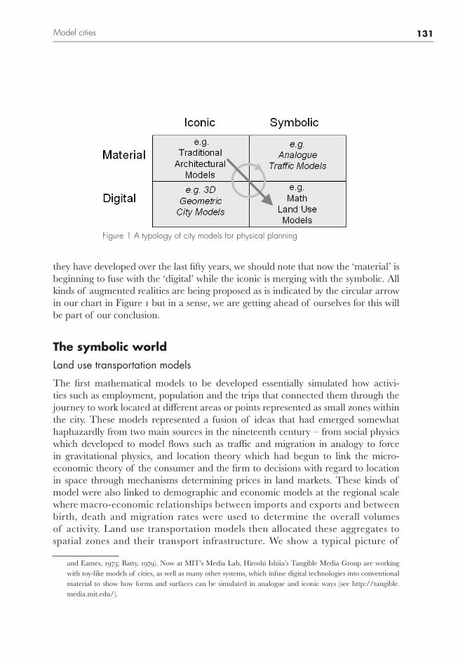
wide and pull in many examples traditionally dealt with separately, and often associ-ated with very diff erent disciplinary traditions and skills. To do this, we will adopt a two-way classifi cation that results from arraying the material–digital continuum against the iconic and symbolic. Figure 1 shows this array and details examples that fall into the four categories that bound the range.
Before the digital computer, models insofar as they were articulated at all for cities and city planning were mainly iconic, built from traditional materials, and used to display 2D and 3D physical designs. Yet even in Abercrombie’s time, there was a sense in which planning required more powerful tools and statistical techniques, hence symbolic models were implicit in that abstractions were used to symbolise the social and economic data of cities and display them in maps and charts. Figure 2 shows a picture of Abercrombie and his collaborator, Paton Watson, examining their plan for Plymouth in 1945. They are using a familiar icon of the centre of the city built in material terms but arrayed against the backcloth are histograms of economic activi-ties in the town2 and traffi c maps displayed in analogy to fl uid fl ow.
Abercrombie worked on his plan for Plymouth just as the digital computer left the crucible and entered the world of science and commerce. Although it was barely realised at the time, this marked the beginnings of the information society. Many diff erent applications of computers were made in a variety of professional and scien-tifi c fi elds and by 1955 computer models of cities were on the horizon. By 1965, many variants of mathematical model of land use location and traffi c fl ow had been devel-oped (Harris, 1965) in a time when the term model became synonymous with the systems approach which was sweeping the planning world by storm (McLoughlin, 1969; Chadwick, 1971). Figure 1 shows this rather rapid transition from material icon to digital symbolism by the downward arrow, and since then, it took a revolution in computer graphics (and to an extent in communications through the internet) to move the fi eld back towards the development of digital icons represented by the left pointing arrow.
The development of analogue models in the material world has always remained a curiosity in planning with their role as demonstrators rather than predictors, and it is only quite recently that analogue models of cities in terms of surfaces and fl ows which fuse the material with digital – as ‘digital clay’, for example, have come back onto the scene at places like MIT’s Media Lab. They remain at best, as their labelling suggests, analogies.3 Before we march on to illustrate the various classes of model and how
2 Note the fact that the histogram shows that the Navy Yard indicated by battleships is the second largest employer in the town.
3 Wassily Leontief, the inventor of the input–output model which has been widely applied in planning from the 1960s, fi rst demonstrated his model in the 1940s at MIT using John Wilbur’s simultaneous equation solver. This machine was built of rods representing each equation on a frame. When the matrix equations converged to a solution, the frame stopped vibrating, as good an example as you can have of a mechanical analogue (Eames
TPR78_2_02_Batty_Colour.indd 130 21/6/07 08:11:39
Model cities 131
they have developed over the last fi fty years, we should note that now the ‘material’ is beginning to fuse with the ‘digital’ while the iconic is merging with the symbolic. All kinds of augmented realities are being proposed as is indicated by the circular arrow in our chart in Figure 1 but in a sense, we are getting ahead of ourselves for this will be part of our conclusion.
The symbolic worldLand use transportation models
The fi rst mathematical models to be developed essentially simulated how activi-ties such as employment, population and the trips that connected them through the journey to work located at diff erent areas or points represented as small zones within the city. These models represented a fusion of ideas that had emerged somewhat haphazardly from two main sources in the nineteenth century – from social physics which developed to model fl ows such as traffi c and migration in analogy to force in gravitational physics, and location theory which had begun to link the micro-economic theory of the consumer and the fi rm to decisions with regard to location in space through mechanisms determining prices in land markets. These kinds of model were also linked to demographic and economic models at the regional scale where macro-economic relationships between imports and exports and between birth, death and migration rates were used to determine the overall volumes of activity. Land use transportation models then allocated these aggregates to spatial zones and their transport infrastructure. We show a typical picture of
and Eames, 1973; Batty, 1979). Now at MIT’s Media Lab, Hiroshi Ishiia’s Tangible Media Group are working with toy-like models of cities, as well as many other systems, which infuse digital technologies into conventional material to show how forms and surfaces can be simulated in analogue and iconic ways (see http://tangible.media.mit.edu/).
Figure 1 A typology of city models for physical planning
TPR78_2_02_Batty_Colour.indd 131 21/6/07 08:11:39

Michael Batty132
output from these models in terms of a traffi c fl ow diagram in Figure 3.4
This tradition fell into disrepute almost as soon as it began. Building such experi-mental models on the fl y with no chance to test them in the rarefi ed environment of the university or think tank before they were applied in policy was not a good recipe for establishing their worth. Data was often lacking, computation was often infeasible for the size of models proposed and, like the space race to which it was often compared, costs escalated out of control. Nevertheless, a vibrant and continuing research tradition, in fact, the only such tradition which resembles anything like those in the physical and biological sciences, came to be established in which these models were linked slowly but fi rmly to micro-economic theory (Wilson, 1970; Ben Akiva and Lerman, 1985). The models, of course, only simulated locational activities, they did not deal with deprivation and economic inequalities and they were not well linked to the built environment. Although they were called ‘land use’ models, they did not relate locational activities very well to the physical characteristics of land use. Thus in terms of their representation as well as their mismatch with policy, they were too abstract and often appeared irrelevant to the problems at hand (Lee, 1973). In some respects, they defi ned away the key dimensions of planning – time and change – insisting on cities being simulated as though they were in equilibrium at a snapshot in time. Moreover they were foisted onto a professional world of planners and policy makers who wanted to be convinced that this kind of science contained its own magic but who knew deep down that there was no such thing.
This tradition, however, still provides the most extensive applications of mathe-matical models in planning despite the fact that many planning problems do not and never will fall within their remit. But for issues where urban growth and sprawl is key, and where transport problems abound, there is no alternative and the models are useful (Wegener, 2004). The obvious limits to this kind of model which are largely spatial in focus, involve the functions of the urban system that they do not represent or simulate. Moreover the fact that the outputs of these models are diffi cult to frame in the physicalist way in which town and country or urban and regional planning is imple-mented, posed further limits on their use. However, the fi eld moved on. First there was a continuing tradition of developing deeper spatial, aspatial and non-spatial processes through new ideas in economics, network science and complexity theory that these models are being drawn into. Second, the quest began to develop much more physi-cally-oriented variants of models that simulate ways in which land is developed and occupied in cities. It is this second view that we will pick up on here for the fi rst tradi-tion which encompasses much research into urban studies does not necessarily lead directly to mathematical computer models. This is yet another way in which we will
4 These predicted fl ows are generated from a land use transportation model developed in the late 1960s (from Batty, 1976). This contrasts with the work-trip fl ows shown at the top right of Figure 2 and produced ‘by hand’ in Abercrombie’s work on Plymouth.
TPR78_2_02_Batty_Colour.indd 132 21/6/07 08:11:39

Model cities 133
Figure 2 Abercrombie (right) and Paton Watson in 1945 with their Plan for Plymouth, and the ‘models’ that they used (from http://www.cyber-heritage.co.uk/history/plan.jpg/)
Figure 3 An early aggregate computer simulation of work trips between coarse zones in a large metro-politan area.
bound this discussion. Our focus here is largely on models that generate and inform us about the physical character of cities for which the kind of institutionalised planning espoused by Abercrombie and all who work in his tradition is most relevant.
Morphological models: cellular automata
Even though land use transportation models were focused primarily on urban growth, their predictions did not map easily onto the ways in which physical planning had developed idealised conceptions of city forms. In short, these models were not physical enough in their predictions and it was hard to see how such models could generate compact, radial, ribbon, sectoral and other morphologies that had become icons of urban planning. In fact, these types of form represented a mixture of both reality and ideology for they could be recognised in the way cities had developed and also contained the seeds of how they should develop. Compact cities for example repre-sented an ideal to be aspired to if densities were to be maximised and trip making to be minimised; diff use and sprawling structures conceptualised the opposite with
TPR78_2_02_Batty_Colour.indd 133 21/6/07 08:11:39

Michael Batty134
adherents adopting both extremes to articulate what the best future city forms might be. Grid systems represented an ideal way of implementing urban plans but were also widely used in situations of rapid growth in contrast to radial growth around and away from a centre which tended to be the way in which cities grow naturally or organically (Kostof, 1991).
This kind of thinking is very deeply rooted in modern town planning, so much so that in 1933 Abercrombie began his book with these conceptions as the focus of what physical planning was all about. His original fi gures5 are shown in Figure 4 and although the characteristic pattern predicted by land use transport models, as pictured in Figure 3 for example, might be consistent in some way with these forms, it is a stretch to make the connections. It is far too simplistic to attribute the tensions over this fi rst style of mathematical modelling to an ability to merely generate patterns but it did mean that early models in planning were exceptionally diffi cult to communicate, as much because the visual apparatus which planners and policy makers required to make sense of the world was lacking. In fact, this had to wait until computer technologies developed to the point at which such models could be better communicated. By the time this arrived – fortuitously one might add because there was nothing in land use transportation modelling to suggest that this would be the case – the models themselves and our conceptions of what was important in cities and city planning had changed.
As computer power accelerated though miniaturisation, the age-old notion of the computer being the universal machine began to be realised, fi rst through graphics, then through text processing, and now through speech and other forms of qualitative
5 Abercrombie’s Figures 1, 2 and 3 which are composed in Figure 4 are taken from his 1933 book Town and Country
Planning, pages 12–17
Figure 4 Abercrombie’s real and idealised model cities
TPR78_2_02_Batty_Colour.indd 134 21/6/07 08:11:40

Model cities 135
pattern recognition. From the beginning, computers had been used for rudimentary graphics but after the microprocessor was invented in 1971 and the microcomputer revolution began from the grass roots, computer graphics accelerated rapidly through games at fi rst and then through graphic user interfaces to access routine software, and now through web browsers. In short, Figures 2, 3 and 4 in this paper which were initially constructed using photographs, manual drawing and traditional model making skills, representing conventional ways of communicating planning ideas, would now be generated digitally.
In one sense, more visual models of cities could not be built until computer graphics and cartography progressed to generate geographic information systems (GIS). In parallel, ideas about modelling change in cities from the bottom up in contrast to cross sections of urban structure from the top down led to notions that good models of cities should lead to emergent patterns formed by the myriad of land-development decisions (Batty, 2005). GIS also brought forward the idea that physical landscapes could best be represented by gridded data, consistent with the notion that every part of the land surface is of equal weight and consistent with the way physical data was captured using remote sensors. The new modelling styles moved away from data associated with administrative units to data associated with pixels and grids. Into this nexus came bottom-up models in which development was considered to be
Figure 5 How cellular automata work: (a) a neighbourhood applied to (b) a grid which generates (c) a pattern of development
TPR78_2_02_Batty_Colour.indd 135 21/6/07 08:11:40

Michael Batty136
cellular and the rules to drive such development were based on notions of what was happening in the immediate vicinity of the cells in question – in their neighbour-hoods. Cellular automata thus provided the natural focus for this new class of model (Couclelis, 1985).
In essence, land development is based on accessibility to land use types and activi-ties at a distance from the site in question subject to various physical constraints and land suitability encoded as cellular development rules operated sequentially through time. This enables cities to be simulated from the bottom up, urban morphologies to emerge physically, and the dynamics of urban development to be captured. Moreover this ensured that the model predictions could be visualised in readily understandable ways, in the same way Abercrombie illustrated his real and ideal city forms in Figure 4. Cellular models thus operate by setting local rules about how a site develops in a neighbourhood of adjacent sites or cells as we show in Figures 5(a) to (c) where simple rules lead to the kinds of patterns that we show in Figure 6(a). These are clearly idealisations with no randomness or heterogeneity but it is easy to perturb such rules stochastically so that much more realistic looking forms might be generated as in Figure 6(b).
Figure 6 Typical patterns from different rule sets: (a) regular patterns generated from different confi gurations and rules for the amount of neighbourhood fi lled, and (b) more realistic fi lling rules involving heterogeneity of choice.
TPR78_2_02_Batty_Colour.indd 136 21/6/07 08:11:40

Model cities 137
It is a large leap to real cities but in Figure 7 we show some real and simulated morphologies from which the reader must take it on faith that there is a class of models based on cellular automata principles that can generate such forms. There are many variants of such models and some of these have even been embedded into integrated frameworks linking to more aggregate cross sectional land use transportation models demonstrating that these traditions now exist in parallel, each capturing diff erent aspects of the urban system (Engelen et al., 2003). This is much the same as the many paradigms that now dominate the explanation and justifi cation of planning itself. Before we briefl y introduce a third variety of urban model developed during the past fi fty years, we should note that the theoretical rationale behind the way location and movement take place in these models is based on common foundations enmeshed in social physics and urban economics where ‘action at distance’ controls much of what happens in city systems. In this sense, although cellular and land use transportation models may appear very diff erent in the ways they allocate land use and activities, they produce the same kinds of output, and the model mechanisms are not so dissimilar.
The models here are unashamedly physical. We must be aware that a key assump-tion, always under scrutiny, is that these spatial patterns reveal socio-economic and cultural processes infl uencing the quality of life which might be made better through
Figure 7 Urban morphologies: regional to local, real to model systems: (a) morphology of urban Britain in terms of city size, (b) down scale to the South East Region, (c) population density (1991) in Greater London, (d) radial retailing clusters in Greater London, (e) street network in Wolverhampton (~500,000 population), (f) diffusion-limited stochastic urban growth, (g) radial traffi c fl ow automata, and (h) dendritic cellular automata
TPR78_2_02_Batty_Colour.indd 137 21/6/07 08:11:40

Michael Batty138
manipulating the physical form of cities. Although this assumption is long standing, it is always contestable for many of the instruments acceptable to western democra-cies imply the quest for a better life through such indirect manipulations. In fact, the jury will always be out as to whether physical planning can make the kind of impact that we assume, but in the last twenty years there has been a rebirth of interest in this kind of physicalism which reveals the signatures of complex processes. The pictures in Figure 7 are highly ordered, revealing self similarity of process on many scales with spatial organisation emerging from the bottom up. Cities are fractal structures (Batty and Longley, 1994) and much progress has been made on measuring their form although we still await the highly promising grand synthesis of form with function which seems ever nearer as urban economic theory begins to fuse with social physics (Krugman, 1996).
One fi nal thought helps complete the loop back to Abercrombie. These models generally produce urban forms marked by heterogeneity and clusters on all scales similar to those in Figure 7. But as the rules behind Figures 5 and 6(a) imply, highly ordered idealisations can be produced by cellular models. In fact, the crennelated forms in Figure 6(a) are similar to the ideal towns produced by Renaissance scholars in fi fteenth and sixteenth century Italy and implemented in many parts of Europe thereafter. These illustrate supreme organisation and self-similarity that echo down the ages to the utopias of the late-nineteenth century best seen in the Garden Cities and New Towns which inspired Abercrombie and his generation. In Figure 8 we show three such ideal cities which might easily have been generated from the application of strict cellular automata. These impress the fact that these model generating mecha-nisms are close in spirit to the top-down physicalism of the ideal- city movement as well as the way cities grow from the bottom up.6
6 Figure 8(a) – Lucca – is from the Military Archives of Sweden at http://www.ra.se/. Figure 8(b) is from Howard, Lock, Hall and Ward (1898, 2003). Figure 8(c) – Le Corbusier’s plan for Paris – is from http://www.volker-goebel.biz/Grafi kenLaDefense3/
Figure 8 Ideal cities: (a) Lucca, Tuscany, sixteenth century, (b) Ebenezer Howard’s City of Tomorrow (the Garden City), 1898, and (c) Le Corbusier’s Plan for Paris, 1945
TPR78_2_02_Batty_Colour.indd 138 21/6/07 08:11:40

Model cities 139
Agent-based simulation models
In the transition from top down to bottom up, from statics to dynamics and from aggregate to disaggregate, symbolic models of cities are now being proposed and implemented in which individual behaviours of objects or events locating and moving in space are being simulated. These are called ‘agents’, a generic term that can include everything from a building to a person or any attribute thereof, or even a more abstract notion such as a fi rm or an institution. The focus is thus on the object itself rather than any aggregate, and the style of simulation relies heavily on developments in object-oriented computer programming. In terms of cities, the most obvious agents are individuals making locational and interactional decisions and it is not surprising that in the shift to fi ner spatial scales, models of traffi c, particularly pedestrian movement, have formed one of the cutting edges of this burgeoning fi eld (O’Sullivan and Haklay, 2000).
Figure 9 Simulating agents moving in space: (a) visitor movements in the Tate Gallery, (b) and simula-tions, (c) pedestrians moving in Wolverhampton town centre, and (d), (e) pedestrians shopping in Covent Garden, London.
TPR78_2_02_Batty_Colour.indd 139 21/6/07 08:11:41

Michael Batty140
Agent-based models, or multi-agent models as they are sometimes called, are in their infancy and represent a modelling style which is being widely developed across the sciences from particle physics to the stock market. In terms of cities, so far there are very few that have been developed for land use transportation although TRANSIMS (Casti, 1996) and UrbanSim (Waddell, 2002) come close, while there are proposals to develop cellular automata models of land development in which agents sit on the cells, making decisions about location and interaction (Xie and Batty, 2005). In a sense, these models like cellular models before do not represent alternatives to past models, but complements, generating another approach and perspective on ways in which cities might be simulated. But what they do provide is a less abstract representation of the system and its behaviour where policy makers and professionals can see how agents as actual individuals are moving within the city, as we show in Figure 9. Such models can be highly visual and provide the obvious extension of 2D ‘map-like’ presentations to the third dimension from the fl ow patterns in Figure 3 to cellular morphologies in Figures 6 and 7 to pedestrian movements in Figure 9.
The iconic worldFrom material to digital icons and back
The popular view of a city model is undoubtedly one based on the city’s architecture. Such models are scaled-down versions of what we experience in the 3D world and as such, they are essential to our learning about places from childhood. To the expert and planning professional, such models are ‘toys’, notwithstanding their usefulness in grasping the essential nature of existing and planned city form. In some respects, such models are much superior to artistic renderings of the future city for they impart a degree of realism and objectivity which visual sketches cannot. The focus in these traditional models is on physical representation in as authentic a form as possible with enough fl exibility to enable the form of the city to be changed quickly but manually and to provide a convenient forum for professional and public debate about the future. Some typical examples of recent models built for London by the Pipers company are shown in Figure 10 where their use in communication and negotiation are quite clear.
Despite there being very obvious ways in which such material models can be repre-sented digitally and communicated on most digital devices from desktops to cinema to hand-held displays and in a variety of interactive contexts, traditional models still hold the power to convince. Digital versions of the same merely complement tradi-tional uses, they do not replace, and this is consistent with the way the digital world has entered our social and professional lives in parallel fashion. Although our focus here is on the digital, traditional models are being augmented with digital interfaces as
TPR78_2_02_Batty_Colour.indd 140 21/6/07 08:11:41

Model cities 141
Figure 10 indicates through ways in which information technologies can supplement traditional materials. But more important is the fact that such models can also now be produced from their digital equivalents, that is ‘printed’ or manufactured from their digital representation and there are even developments of such versions primarily for this purpose. But we are getting ahead of ourselves again and we will return to this point a little later when we complete the circle from material to digital and back again.
3D city models
As soon as computers were invented, computer graphics began with images generated on line printers and display tubes but it took miniaturisation and the micro revolu-tion to really open up the fi eld with the development of packages such as AutoCAD. Representing buildings and cityscapes came early using rudimentary wire-frame CAD shown in Figures 11(a) and (b) but it took the development of geographic infor-mation systems (GIS) and their extension into CAD to enable the routine production
Figure 10 Traditional city models, almost (from http://www.pipers.co.uk/)
TPR78_2_02_Batty_Colour.indd 141 21/6/07 08:11:41

Michael Batty142
of 3D representations of cities. Such representations are not exclusively about the geometry of buildings for landscapes as surfaces and socio-economic data associated with administrative units such as census tracts are widely displayed in 3D as we show in Figures 11(c) and (d). With the introduction of rapid-capture techniques such as airborne laser scanning, however, it is now relatively easy to generate 3D representa-tions of buildings, at least in block form when associated with land parcel and street geometry, and thus the last step in making traditional iconic models digital has been taken.7
What makes the current generation of digital 3D models important is the notion that such models are simply databases that can store any kind of spatial urban data
7 This image is taken from Beacon and Boreham (1978). The fi gure is reprinted by permission from Batty (1980).
Figure 11 Early geometric-geographic 3D city and landscape models: (a) a wire frame with hidden line elimination on a display tube,7 (b) a raw wire frame of Central London, (c) a socio-economic landscape in 3D, and (d) 3D thematic populations.
TPR78_2_02_Batty_Colour.indd 142 21/6/07 08:11:41

Model cities 143
with their geographical referent being any coordinate system but with the most eff ec-tive being buildings and streets. In short, the new models are not simply the digital geometry of traditional models but large-scale data bases which can be viewed in 3D. As such, they already represent a way of merging more abstract symbolic or thematic data, even symbolic models, into this mode of representation. In Figure 12(a), we show a typical building geometry on the basis of extruded land parcel blocks with a detailed laser scanned/sensed building within, and in 12(b) a full scale rendition of such a block model for part of central London. In 12(c), we show how we can merge another layer – a surface – into this geometry where we plot a layer of nitrogen dioxide synthesised
Figure 12 Digital 3D city models with different data layers: (a) reconstructing 3d from airborne sensed (LiDAR) height data, (b) building blocks layered onto aerial photography, (c) nitrogen dioxide layered onto the street system, and (d) querying buildings developed from 2001 to 2004.
TPR78_2_02_Batty_Colour.indd 143 21/6/07 08:11:42

Michael Batty144
from both data and a pollution model calibrated to the street system, indicating in one way how the outputs from a symbolic model can be represented. In a sense, digital iconic and symbolic models are alternatives no longer but are beginning to fuse – the use of iconic models merely for visualisation of the city’s geometry is in fact only the most superfi cial usage of such models. In Figure 12(d), we show how the results of a complex query of the buildings data base for such a model can be visualised in which the highlighted blocks are those built in the fi nancial area of central London between 2001 and 2004.
Augmented realities and new media
The dominant way of delivering both iconic and symbolic digital models is still to individual users through the desktop or the workstation. Software has become ever higher level as users can now relate to such models much more passively than hitherto with users being served such models to their standalone clients over local networks. However, this is changing as models are increasingly being served to not one but many users across the internet. These are based on the notion of embedding elements of their software into web browsers which enable large numbers of unknown users to access and manipulate such models. This is the case with the simpler models, particu-larly the iconic. The best current example is Google Earth which enables any user to add map and now 3D digital content to any location on the globe and serve this to any user who can then manipulate the model adding their own content if they so wish. This has enormous implications for involving professionals and the wider public in this kind of science and we will explore its implications more fully in our conclusions. We show such a development in Figures 13(a) and (b) for the model of London that we have used to illustrate these icons.
We can also merge digital models with their non-digital equivalents. Even if a traditional model is the focus, then it can be augmented using various information technologies as, for example, in the various iconic models produced for London shown earlier in Figure 10 where the material components of the model are linked to computer technologies which show pictorial detail and lighting that are not as eff ectively produced with traditional materials. Just as we can print paper maps using computer cartography and GIS, we can ‘print’ or ’publish’ various representations of the 3D iconic model using CAD–CAM printing capabilities. We show this for an extract from our London model in Figure 13(c). In this way we can return to a variant of the traditional representation and there is even the prospect of building digital models primarily so that better material models may be produced more rapidly, in volume, and in diff erent variations. In a wider context and at rather larger spatial scales, the prospect actually exists of manufacturing entire buildings from such digital models, perhaps whole city blocks, indeed entire cities for this is little diff erent from
TPR78_2_02_Batty_Colour.indd 144 21/6/07 08:11:42

Model cities 145
other automated production. Although this might appear fanciful, there are many straws in the wind – Japanese cities, for example, have a form that is being rapidly subjected to such possibilities, and before the end of the twenty-fi rst century, we may see cities being ‘grown’ in situ from such digital designs rather than ‘manufactured’ remotely and brought to the site.
Our last foray into ways in which symbolic and iconic models might be augmented is through the notion that once a digital model exists, it can be embedded in other digital environments, either on the desktop or across the network. Out of gaming has come the idea of the virtual world in which a digital environment, usually in 3D and located on some remote server, can be accessed over the web by many diff erent users who appear as ‘avatars’ in such scenes. Their digital persona can be manipulated in the environment so they can move, converse, and gesture, interacting with other avatars as well as changing the environment in various ways. In terms of iconic models, we can
Figure 13 New media for displaying digital iconic models: (a) and (b) zooming into London in Google Earth, (c) publishing the 3D model by CAD-CAM printing, and (d) the model in a virtual world of users appearing as avatars from remote locations.
TPR78_2_02_Batty_Colour.indd 145 21/6/07 08:11:42

Michael Batty146
place these in traditional looking form in such worlds where avatars – ourselves as users – can then manipulate the digital city model as if one were changing the location of types of buildings in a traditional model. In Figure 13(d), we show this for part of our London model where the avatars can move the buildings around as if this were a virtual design studio. The possibilities for such embedding are indeed endless. The model shown in the virtual environment in Figure 13(d) can in turn be embedded in one of its own buildings through which the avatar might enter in the manner of the old adventure games ‘dungeons and dragons’.
We are standing on the threshold of such digital recursion and this promises to change science, society, and cities in ways that we can barely comprehend. In a sense, we have moved full circle from dealing with cities using traditional media in terms of representation and functioning as pictured in Figure 2 to the virtual world in Figure 13(d). It is as if Abercrombie were to have stepped into a world where he could test his plan through manipulating the city over and over again but remotely in dialogue with other colleagues. Yet as we will see in the next concluding section, the digital world is pushing us into environments where not only models and actors of diff erent kinds merge virtually but one in which our abilities to change the real world can also be accomplished digitally.
Merging symbolic and iconic modelsAlthough the key tools used by Abercrombie which were pictured in Figure 2 have become digital, and the environment in which they are used is becoming virtual, this new world takes us well beyond what Abercrombie was able to envisage. Since its inception we have been told that the digital computer is a universal machine, capable of being adapted to any problem or circumstance, and it never ceases to surprise us what this simple truth means. The models we have dealt with here span two extremes from symbolic functionalism to iconic representation and for much of the last fi fty years, their digital embodiment was suffi ciently diff erent to require diff erent skills, perspectives, and users. But these are merging. Symbolic models can be operated within iconic environments – mathematical models can run within a 3D environment, their predictions can be converted into a form that is compatible with such environ-ments, and users can actually watch their operation in computer time. Such visuali-sations enable model designers and users to see how good the model is, particularly models which are predicting human behaviour where we can sense how close their behaviour is to our own experience. In Figure 14, we show some very rudimentary results from such embeddings where pedestrian models based on the behaviour of agents fl ocking, crowding and fulfi lling key tasks involving purposive movement in space, can be visualised in a way that makes their behaviour transparent. As in all iconic representation, the closer the environment to the real thing, the easier it is to
TPR78_2_02_Batty_Colour.indd 146 21/6/07 08:11:42

Model cities 147
Figure 14 (a) Simple embedding of local movement models into 3D environments
Figure 14 (b) Simple embedding of local movement models into 3D environments
appreciate what is happening – tables of numbers are less easy to comprehend than maps which in turn are less intuitive than 3D scenes.
A simpler embedding is to take the outputs of symbolic models, to translate these into iconic representations and to display these remotely through the web. In fact, simplifi ed versions of various spatial models are already embodied in web formats. In Figure 15, we show the outputs of an air-pollution model running for central London. Based on a symbolic hydrodynamics of air fl ow which is infl uenced by the 3D geometry of the built environment produced from an iconic model and linked to real time pollu-tion sensor stations, the model spreads the pollutants to the street system which is visualised in 2D map and 3D virtual city form. The interface through the web is to the data not the model, to the model’s predictions as well as observations. The slider bar enables the user to examine predictions for various pollutants over a ten year period while clicking on the map generates 3D scenes which are taken from embedding the data and predictions in the iconic model as we illustrated previously in Figure 12(c).
It is entirely possible to take all these kinds of embedding into the virtual world in which users are represented as avatars. Imagine the models shown in Figure 14 being enabled in the kinds of environment shown in Figure 13(d) which in turn are acces-sible remotely through the web, in Google Earth even. Here we might imagine a mix of
TPR78_2_02_Batty_Colour.indd 147 21/6/07 08:11:42

Michael Batty148
‘real’ users with ‘simulated actor-agents’ where the ways in which they mix refl ect the purposes to which the virtual environment is constructed, in our case for design and planning. We can go one step beyond this. Imagine a context in which not only ‘model agents’ and ‘real users’ are mixed with ‘real agents’ in real-time environments. Data about the real world is piped into the virtual environment directly and within this, models of behaviour are constructed and run alongside the real-time observation of what is actually happening. Into this nexus come ourselves as users appearing virtu-ally with the simulated and the real. All this is accomplished digitally with the distinc-tion between the real digital and the simulated digital at last becoming signifi cant.
Lest this be thought fanciful, it is not far away. For a decade or more since the World Wide Web was established, access to reality viewed through web pages has become routine. Indeed the laptop on which I am writing this paper has a web cam which would enable you to see me engaged in this activity were I connected to a web page in real time. This is no more or less than piping real-time data into the scene in Figure 13(d), capturing it and then visualising it digitally. Linking such data to simula-tions is now routine. An even bolder speculation suggests itself. The 3D environment itself – or rather the 3D representation of the real environment in the virtual world, the city model – could be constructed in real time from various sensors. The built environment is forever changing and with virtually continuous remote sensing, such environments might be constructed on the fl y. The virtual world in Figure 13(d) would be changing continually as data about the functioning of the city in terms of its people and built form was continually piped in, iconic models would capture this data and reconstruct the model city wherever the real city changed, and symbolic models would enable us to make sense of its functioning.
Into this we would come as users making sense of all this variety in real time while proposing changes to the city which would improve its functioning and quality of life, reinforcing planning goals little diff erent from those that have dominated since institutionalised planning began. There is one more step. With such synthetic digital environments, our models also enable the environment to be reconstructed in physical terms from its digital representation as whole sections of cities in their physical form are reproduced from digital models. One level up, we might imagine all this being embedded in a real-time digital economy where many of our other needs are fashioned from digital models – the possibilities are endless.
All of this sounds as though it comes from the science fi ction of William Gibson and Philip K. Dick – from Blade Runner and The Matrix, but it is not as far fetched as it sounds. It is already present in many forms and there are few technical obstacles to it occurring. The limits are organisational, subject of course to the desires and purposes to which such synthetic worlds might be put. The clusters of models enabled in such environments would run in parallel to the real world and issues of connecting them in sensible ways and embodying them in purposive actions pose enormous
TPR78_2_02_Batty_Colour.indd 148 21/6/07 08:11:43

Model cities 149
Figure 15 Embedding outputs of air pollution models into 2D and 3D environments within web pages
challenges. These are well beyond the scope of what we have written about here but they are nonetheless essential in realising some of these speculations. What is clear, however is that in our quest to abstract and simplify, we have moved well beyond what Abercrombie imagined. Nevertheless the seeds of what he said and practised contained in his paradigmatic statement of Town and Country Planning (1933) still dominates our rationale for developing these new models and the problem contexts in which we need to apply them.
Referencesabercrombie, p. (1933), Town and Country Planning, London, Thornton Butterworth.batty, m. (1976), Urban Modelling: Algorithms, Calibrations, Predictions, Cambridge, Cambridge
University Press.batty, m. (1979), ‘Progress, success and failure in urban modelling’, Environment and Planning A,
11, 863–78.batty, m. (1980), ‘Computers and design: the new challenge to urban planning’, Cardiff , Wales,
UWIST Papers in Planning Research, 2, 1–32.
TPR78_2_02_Batty_Colour.indd 149 21/6/07 08:11:43

Michael Batty150
batty, m. (1997), ‘The computable city’, International Planning Studies, 2, 155–73.batty, m. (2005), Cities and Complexity: Understanding Cities Through Cellular Automata, Agent-Based
Models and Fractals, Cambridge, MA, MIT Press.batty, m. and hudson-smith, a. (2005), ‘Urban simulacra’, Architectural Design, 75, 42–7.batty, m. and longley, p. a. (1994), Fractal Cities: A Geometry of Form and Function, London,
Academic Press.beacon, g. r. and boreham, p. g. (1978), ‘Computer-aided architectural design at Leeds
Polytechnic’, Computer-Aided Design, 10, 325–31.ben akiva, m. and lerman, s. (1985), Discrete Choice Analysis, Cambridge, MA, MIT Press.calvino, i. (1974), Invisible Cities, New York, Harcourt Brace and Company.casti, j. l. (1996), Would-Be-Worlds: How Simulation Is Changing the Frontiers of Science, New York,
John Wiley.chadwick, g. f. (1971), A Systems View of Planning, Oxford, Pergamon.couclelis, h. (1985), ‘Cellular worlds: a framework for modeling micro–macro dynamics’,
Environment and Planning A, 17, 585–96.eames, c. and eames, r. (1973), A Computer Perspective, Cambridge, MA, Harvard University
Press.engelen, g., white, r., and de nijs, t. (2003), ‘Environment explorer: spatial support for the
integrated assessment of socio-economic and environmental policies in the Netherlands’, Integrated Assessment, 4, 97–105.
harris, b. (1965), ‘Urban development models: a new tool for planners’, Journal of the American Institute of Planners, 31, 90–95.
howard, e., lock, d., hall, p. and ward, c. (1898, 2003),Tomorrow: A Peaceful Path to Real Reform, London, Routledge.
kaldor, n. (1972), ‘The irrelevance of equilibrium economics, Economic Journal, 82, 1237–55.kostof, s. (1991), The City Shaped : Urban Patterns and Meanings Through History, London, Thames
and Hudson.krugman, p. (1996), The Self-Organising Economy, Boston, MA, Blackwell.lee, d. b. (1973), ‘Requiem for large-scale models’, Journal of the American Institute of Planners, 39,
163–78.lowry, i. s. (1965), ‘A short course in model design’, Journal of the American Institute of Planners,
31, 158–65. mcloughlin, j. b. (1969), Urban and Regional Planning: A Systems Approach, London, Faber and
Faber.morrison, m. (1999), ‘Models as autonomous agents’, in M. S. Morgan and M. Morrison (eds),
Models as Mediators: Perspectives on Natural and Social Sciences, Cambridge, Cambridge Univer-sity Press, 38–65.
o’sullivan, d. and haklay, m. (2000), ‘Agent-based models and individualism: is the world agent based?’, Environment and Planning A, 32, 1409–25.
van der leeuw, s. e. (2005), ‘Why model?’, Cybernetics and Systems, 35, 117–28.waddell, p. (2002), ‘UrbanSim: Modelling urban development for land use, transportation
and environmental planning’, Journal of the American Planning Association, 68, 297–314.wegener, m. (2004), ‘Overview of land use transport models’, in D. A. Hensher and K. Button
TPR78_2_02_Batty_Colour.indd 150 21/6/07 08:11:43

Model cities 151
(eds), Transport Geography and Spatial Systems (Handbook 5 of the Handbook in Transport), Kidlington, Pergamon–Elsevier Science, 127–46.
wilson, a. g. (1970), Entropy in Urban and Regional Modelling, London, Pion Press.xie, y., and batty, m. (2005), ‘Integrated urban evolutionary modelling’ in P. M. Atkinson, G.
M. Foody, S. E. Darby and F. Wu (eds), Geodynamics, Boca Raton, FL, CRC Press, 273–93.
AcknowledgementsThanks to Andy Hudson-Smith for all his work on Virtual London and for the images in Figures 11(b), 12(b), 12(d), 13(b), 13(c), and 13(d); to Steve Evans for his work on embedding pollution models in Virtual London in Figures 12(c) and 15; to John Ward for his work on the Covent Garden model in Figures 9(d) and (e); to Mark Thurstain-Goodwin for the London town centres surface in Figure 11(c); and to Alasdair Turner and Vassilis Zachariadis for the pedestrian visualisations in Figure 14.
TPR78_2_02_Batty_Colour.indd 151 21/6/07 08:11:43

TPR78_2_02_Batty_Colour.indd 152 21/6/07 08:11:43