fsh 1909.12 - land management planning handbook chapter … · id_1909.12-2008-2 page 1 of 41...
TRANSCRIPT

id_1909.12-2008-2 Page 1 of 41
FOREST SERVICE HANDBOOK NATIONAL HEADQUARTERS (WO)
WASHINGTON, DC
FSH 1909.12 - LAND MANAGEMENT PLANNING HANDBOOK
CHAPTER 10 - LAND MANAGEMENT PLAN
Interim Directive No.: 1909.12-2008-2 Effective Date: November 13, 2008 Duration: This interim directive expires on May 13, 2010. Approved: GREGORY SMITH Acting Deputy Chief
Date Approved: 10/17/2008
Posting Instructions: Interim directives are numbered consecutively by handbook number and calendar year. Post by document at the end of the chapter. Retain this transmittal as the first page(s) of this document. The last interim directive was 1909.12-2008-1 to chapter 60. New Document
id_1909.12-2008-2 41 Pages
Superseded Document(s) (Interim Directive Number and Effective Date)
None
Digest: Notice of issuance of this interim directive was published in the Federal Register on November 13, 2008 (73 FR 67120). The Forest Service is issuing this interim directive to clarify the procedures for writing plan components, for describing the monitoring program, and for considering individual resources. Makes minor technical and editorial changes throughout the document. 10.2 - Sets forth direction for employee accomplishments when developing, amending, or revising a land management plan. Removes obsolete direction on objectives. Sets forth direction about the nature of planning and about adapting the plan to changing situations, previously in section 11.

WO INTERIM DIRECTIVE EFFECTIVE DATE: 11/13/2008 DURATION: This interim directive expires on 05/13/2010.
id_1909.12-2008-2 Page 2 of 41
FSH 1909.12 - LAND MANAGEMENT PLANNING HANDBOOK
CHAPTER 10 - LAND MANAGEMENT PLAN Digest--Continued: 10.4 - Establishes code and caption for “Responsibility.” Sets forth direction for plan development, plan amendment, and plan revision; continuously adapting the plan to changing situations; and using a collaborative and participatory approach. Adds cross-reference to chapter 30 of this handbook for collaboration for planning. Sets forth direction for developing projects and activities previously in section 11. 11 - Changes caption from “Plan Components and Proposed and Possible Actions” to “Plan Components and Other Plan Content.” Removes direction about the nature of planning, about adapting the plan to changing situations, and about developing projects and activities and recodes this direction to sections 10.2 and 10.4. Removes obsolete direction about developing budgets. 11.1 - Removes direction that a plan must include provisions required by Title 16, United States Code sections 1604 and 1611. Sets forth direction that the plan must include resource management provisions required by Title 36, Code of Federal Regulations, section 219.9(b) and that plan components should not include explanatory narrative. Adds cross-reference to the plain language Web site. Adds definition of geographic areas. Removes obsolete reference to technical guide “Developing Plan Components with Examples.” 11.1 - Exhibit 01 - Clarifies the example plan components in exhibit 01 and removes the footnote. 11.11 - Clarifies and sets forth new direction that desired conditions are written to meet the intent of the planning rule. Adds a list of the characteristics of desired conditions. 11.12 - Clarifies and sets forth new direction that objectives are written to meet the intent of the planning rule. Adds a list of the characteristics of objectives. 11.13 - Clarifies and adds additional direction so that guidelines are written to meet the intent of the planning rule. Adds a list of the characteristics of guidelines. 11.14 - Clarifies and sets forth new direction that the identifications of suitability of areas are written to meet the intent of the planning rule. Adds that plans may identify areas as “not generally suitable” for uses. Adds that any substantive change in plan suitability for timber production may only be made by a plan amendment. Adds a list of the characteristics of suitability of areas. Clarifies that identification in a plan of suitability is tentative and final suitability is determined when projects and activities are approved.
WO INTERIM DIRECTIVE EFFECTIVE DATE: 11/13/2008 DURATION: This interim directive expires on 05/13/2010.
id_1909.12-2008-2 Page 3 of 41
FSH 1909.12 - LAND MANAGEMENT PLANNING HANDBOOK
CHAPTER 10 - LAND MANAGEMENT PLAN Digest--Continued: 11.15 - Clarifies and sets forth new direction that identification of special areas meets the intent of the planning rule. Also, sets forth direction to deal with the situation where the responsible official lacks authority to designate a special area, that a plan may establish other plan components for special areas and that if an area does not meet the qualifications for a special area it may be identified as a management area. Removes direction referencing proposed adjustments in national forest boundaries and recodes direction to section 13.13f. 11.15 - Exhibit 01 - Adds historical area, national heritage area, paleontological area, recreational area, scenic area, and zoological area. Clarifies the designation authority for areas. 11.16 - Establishes code and caption for “Standards” and sets forth direction for writing standards in accord with Title 36, Code of Federal Regulations, section 219.7(a)(3). Adds a list of the standards characteristics. 11.16a - Establishes code and caption for “Actions That Are Not Standards” and sets forth direction that final decisions for authorizing projects, closure orders, or designating roads for motor vehicle use are not standards. 11.16b - Establishes code and caption for “New Standards to Be Approved As Part of Plan Development, Plan Amendment or Plan Revision” and sets forth that new standards are outside the scope of the planning categorical exclusion under Title 36, Code of Federal Regulations, Part 220–National Environmental Policy Act (NEPA) Compliance (36 CFR 220.6(e)(16). 11.16c - Establishes code and caption for “Retaining, Revising, or Removing Existing Standards” and sets forth that during amendment or revision of plans under the planning rule (36 CFR part 219), the responsible official must consider whether to retain, revise, or remove existing standards. 11.16d - Establishes code and caption for “Documenting Retaining and Revising Standards” and sets forth requirements for documenting in the plan approval document and the required evaluation report. Sets forth that typically no further NEPA analysis is required for previously analyzed standards when retaining or revising standards. Sets forth guidance for exceptions to using the planning categorical exclusion ((36 CFR 220.6(e)(16) when retaining or revising standards. 11.16e - Establishes code and caption for “Documenting Removing Standards” and sets forth that the required documentation report must identify which standards are removed and provide a rationale for the removal. Sets forth that typically no further NEPA analysis is required to remove standards. Sets forth guidance for exceptions to using the planning categorical exclusion ((36 CFR 220.6(e)(16) when removing standards.

WO INTERIM DIRECTIVE EFFECTIVE DATE: 11/13/2008 DURATION: This interim directive expires on 05/13/2010.
id_1909.12-2008-2 Page 4 of 41
FSH 1909.12 - LAND MANAGEMENT PLANNING HANDBOOK
CHAPTER 10 - LAND MANAGEMENT PLAN Digest--Continued: 11.2 - Changes caption from “Proposed and Possible Actions” to “Project and Activity Consistency with the Plan.” Recodes to this section exhibit 01, Plan Consistency Template, that contains template wording for plan consistency previously set out in section 11.4. Clarifies existing direction and adds wording for standards. 11.3 - Changes caption from “Plan Guidance for Special Conditions or Situations” to “Possible Actions.” Recodes to this section direction previously set out in section 11.2. Also clarifies direction to meet the intent of National Forest Management Act. 11.4 - Changes caption from “Plan Component Consistency During Implementation” to “Plan Guidance for Special Conditions or Situations.” Recodes to this section direction previously set out in section 11.3. 11.5 - Establishes code and caption and sets forth direction for including “Other Information” in plans and plan components. 11.6 - Establishes code and caption and sets forth direction for including “Management Approaches” in plans. 12 - Clarifies and sets forth direction for using the monitoring and evaluation framework described in the “NFS LMP Monitoring and Evaluation Framework.” Removes direction that monitoring must address the timber requirements of the National Forest Management Act. Sets forth direction that monitoring must focus on where there is substantial uncertainty over the effectiveness of a plan component in contributing to the achievement or maintenance of desired conditions. 12 - Exhibit 01 - Clarifies the examples of desired conditions and questions in the exhibit. 12.1 - Changes the caption from “Monitoring Questions” to “Selecting Monitoring Questions.” Revises the focus of the direction from screening monitoring questions to selecting monitoring questions. 12.2 - Clarifies direction for performance measures. Adds definition of performance measures. 12.3 - Changes caption from “Documenting the Monitoring Program” to “Documents Associated with the Monitoring Program.” Clarifies the terms “annual evaluation report,” “comprehensive evaluation report,” “monitoring guide,” and “annual monitoring work plan.”
WO INTERIM DIRECTIVE EFFECTIVE DATE: 11/13/2008 DURATION: This interim directive expires on 05/13/2010.
id_1909.12-2008-2 Page 5 of 41
FSH 1909.12 - LAND MANAGEMENT PLANNING HANDBOOK
CHAPTER 10 - LAND MANAGEMENT PLAN Digest--Continued: 13 - Clarifies references to direction for considering social, economic, and ecological sustainability; timber; wilderness; wild and scenic rivers in other chapters of this handbook. Removes obsolete direction of three phases of the planning process. Recodes direction requiring the responsible official to identify and select the parameters for evaluation to 13.1. 13.1 - Sets forth direction to evaluate sustainability within an area large enough to consider broad-scale social, economic, and ecological factors and trends over large landscapes. 13.11a - Changed the direction for paleontological resources from a focus on special areas to a focus on considering desired conditions and objectives for paleontological resources. 13.11b - Changes caption from “Air” to “Air Management” and clarifies direction for air management. 13.11c - Clarifies direction for evaluation and establishing plan components for water. 13.11d - Establishes code and caption “Soil” and sets forth direction for evaluation and establishing plan components for soil. 13.12a - Changes caption from “Fire, Aviation, and Fuels Management” to “Fire and Fuels Management” and clarifies direction for fire and fuels management. 13.12b - Clarifies direction for large fire cost containment. Removes reference to Wildland Fire Situation Analysis and Wildland Fire Implementation Plan. 13.13a - Changes caption from “Recreation and Scenery” to “Recreation and Scenery Management” and clarifies direction for recreation and scenery management in the planning process. 13.13b - Changes caption from “Heritage Resources” to “Cultural Resources” and clarifies direction for cultural resources in the planning process. 13.13c - Establishes code and caption “Minerals Including Energy Minerals” and sets forth direction for establishing desired conditions, objectives, and guidelines for minerals. Clarifies and recodes to this section direction about recognizing minerals in the planning process previously set out in 13.13d. 13.13d - Changes caption from “Minerals” to “Range Management.” Clarifies and recodes to this section direction about range management and wild horse-burro territory boundaries in the planning process previously set out in 13.13e.

WO INTERIM DIRECTIVE EFFECTIVE DATE: 11/13/2008 DURATION: This interim directive expires on 05/13/2010.
id_1909.12-2008-2 Page 6 of 41
FSH 1909.12 - LAND MANAGEMENT PLANNING HANDBOOK
CHAPTER 10 - LAND MANAGEMENT PLAN Digest--Continued: 13.13e - Changes caption from “Range Management” to “Access, Roads, Trails, or Travel Management.” Clarifies and recodes to this section direction about access, roads, trails, or travel management in the planning process previously set out in 13.13f. Sets forth direction related to the requirement in the travel management regulations, at 36 CFR 212.5(b) to identify a minimum road system to be documented in the forest transportation atlas. 13.13f - Changes caption from “Road, Facility, Access, and Travel Management” to “Land Use and Special Uses.” Clarifies and recodes to this section direction about land use and special uses in the planning process previously set out in 13.13g. Sets forth direction that if the administrative unit proposes to recommend adjustment in the national forest boundary that the Washington Office is notified. 13.13g - Removes code and caption and recodes direction to 13.13f. 13.2 - Removes code and caption of “Individual Resource Analytical Tools.” The tools previously listed under section 13.2 now discussed under section 13.13a and section 13.13e.

WO INTERIM DIRECTIVE EFFECTIVE DATE: 11/13/2008 DURATION: This interim directive expires on 05/13/2010.
id_1909.12-2008-2 Page 7 of 41
FSH 1909.12 - LAND MANAGEMENT PLANNING HANDBOOK
CHAPTER 10 - LAND MANAGEMENT PLAN
Table of Contents
10.2 – Objectives ........................................................................................................................ 9 10.4 – Responsibility ................................................................................................................ 10
11 – PLAN COMPONENTS AND OTHER PLAN CONTENT....................................... 10 11.1 – Plan Components ........................................................................................................... 11
11.11 – Desired Conditions................................................................................................... 13 11.12 – Objectives ................................................................................................................ 14 11.13 – Guidelines ................................................................................................................ 14 11.14 – Suitability of Areas .................................................................................................. 15 11.15 – Special Areas ........................................................................................................... 17 11.16 – Standards (Optional) ................................................................................................ 19 11.16a – Actions That Are Not Standards ............................................................................ 20 11.16b – New Standards to Be Approved As Part of Plan Development, Plan Amendment or
Plan Revision ............................................................................................................ 20 11.16c – Retaining, Revising, or Removing Existing Standards .......................................... 21 11.16d – Documenting Retaining and Revising Standards................................................... 21 11.16e – Documenting Removing Standards........................................................................ 21
11.2 – Project and Activity Consistency with the Plan............................................................. 21 11.3 – Possible Actions............................................................................................................. 25 11.4 – Plan Guidance for Special Conditions or Situations...................................................... 25 11.5 – Other Information .......................................................................................................... 26 11.6 – Management Approaches .............................................................................................. 26
12 – MONITORING....................................................................................................... 26 12.1 – Selecting Monitoring Questions .................................................................................... 29 12.2 – Performance Measures................................................................................................... 30 12.3 – Documents Associated with the Monitoring Program................................................... 30
13 - CONSIDERATION OF INDIVIDUAL RESOURCES.............................................. 31 13.1 – Resource Considerations................................................................................................ 32
13.11 – Physical Environment .............................................................................................. 33 13.11a – Paleontological Resources ..................................................................................... 33 13.11b – Air Management .................................................................................................... 33 13.11c – Water ...................................................................................................................... 34 13.11d – Soil ......................................................................................................................... 35 13.12 – Biological Environment ........................................................................................... 35 13.12a – Fire and Fuels Management ................................................................................... 35 13.12b – Large Fire Cost Containment................................................................................. 37 13.12c – Wildlife and Fisheries ............................................................................................ 38 13.13 – Social and Economic Environment.......................................................................... 38 13.13a – Recreation and Scenery Management .................................................................... 38 13.13b – Cultural Resources ................................................................................................. 39 13.13c – Minerals including Energy Minerals...................................................................... 39

WO INTERIM DIRECTIVE EFFECTIVE DATE: 11/13/2008 DURATION: This interim directive expires on 05/13/2010.
id_1909.12-2008-2 Page 8 of 41
FSH 1909.12 - LAND MANAGEMENT PLANNING HANDBOOK
CHAPTER 10 - LAND MANAGEMENT PLAN
13.13d – Range Management ............................................................................................... 40 13.13e – Access, Roads, Trails, or Travel Management....................................................... 40 13.13f – Land Use and Special Uses .................................................................................... 41
WO INTERIM DIRECTIVE EFFECTIVE DATE: 11/13/2008 DURATION: This interim directive expires on 05/13/2010.
id_1909.12-2008-2 Page 9 of 41
FSH 1909.12 - LAND MANAGEMENT PLANNING HANDBOOK
CHAPTER 10 - LAND MANAGEMENT PLAN This chapter provides the procedures on writing plan components, on describing the monitoring program, and on considering individual resources.
10.2 – Objectives This objective section explains what responsible officials should strive to accomplish when developing, amending, or revising a land management plan. Each land management plan:
1. Is developed, amended, and revised in accordance with statute, regulations, Executive orders, and agency policy;
2. Provides broad guidance and information for project and activity decisionmaking under Title 36, Code of Federal Regulations, Part 219–Planning, Subpart A–National Forest System Land Management Planning (36 CFR part 219, subpart A);
3. Is part of an adaptive planning process, aimed at producing responsible land management for the National Forest System (NFS) based on useful and current information and guidance to best meet the needs of the American people (36 CFR 219.3);
4. Provides a vision, strategy, and design criteria for management of the plan area, as outlined in the plan model, see technical guide “Foundations of Forest Planning” available on the Technical Information for Planning Site (TIPS) Web site at http://www.fs.fed.us/TIPS;
5. Is based on an evaluation of relevant economic and social conditions and trends in social and economic systems (36 CFR 219.10; Forest Service Manual (FSM) 1921.7; Forest Service Handbook (FSH) 1909.12, ch. 40);
6. Provides a framework to contribute to ecological sustainability, with provisions relating to sustaining ecosystem diversity, and where necessary, additional provisions for threatened and endangered species, species-of-concern, and species-of-interest (36 CFR 219.10);
7. Is written in plain English that is clear, concise, and straightforward;
8. Establishes desired conditions, objectives, suitability of areas, special areas, guidelines, and standards (where appropriate) under Title 36, Code of Federal Regulations, section 219.7(a);
9. Establishes plan provisions for resource management to fulfill the requirements of Title 16, United State Code, section 1604 applying to future projects and activities (36 CFR 219.12(b));

WO INTERIM DIRECTIVE EFFECTIVE DATE: 11/13/2008 DURATION: This interim directive expires on 05/13/2010.
id_1909.12-2008-2 Page 10 of 41
FSH 1909.12 - LAND MANAGEMENT PLANNING HANDBOOK
CHAPTER 10 - LAND MANAGEMENT PLAN
10. Identifies lands not suitable for timber production, lands suitable for timber production, and other lands where trees may be harvested for multiple use values other than timber production (16 U.S.C. 1604(k); 36 CFR 219.12(a)); FSM 1921.12; FSH 1909.12, ch. 60);
11. Establishes the long-term sustained-yield timber capacity (16 U.S.C. 1611; 36 CFR 219.12(c); FSM 1921.12; FSH 1909.12, ch. 60);
12. Establishes the timber sale program quantity as an objective (FSM 1920.12; FSH 1909.12, ch. 60);
13. Provides wilderness recommendations as appropriate where Title 36, Code of Federal Regulations, section 219.7(a)(6)(ii) applies; and
14. Describes the monitoring program (36 CFR 219.6(b)).
10.4 – Responsibility The supervisor of the national forest, grassland, prairie, or other comparable administrative unit is the responsible official for development and approval of a plan, plan amendment, or plan revision for lands under the responsibility of the supervisor, unless a regional forester, the Chief, or the Secretary chooses to act as the responsible official. The supervisor or district ranger is the responsible official for project and activity decisions, unless a higher-level official chooses to act as the responsible official (36 CFR 219.2). Supervisors are responsible for the following:
1. Continuously adapting the plan to changing situations (36 CFR 219.2, FSM 1904.1, FSM 1921.04b); and
2. Using a collaborative and participatory approach for plan development, amendment, and revision of land management plans under the National Forest Management Act (NFMA) of 1976 (16 U.S.C. 1600 et seq.) and Title 36, Code of Federal Regulations, Part 219 –National Forest System Land Management Planning (36 CFR part 219). See chapter 30 of this handbook for further direction about collaboration.
11 – PLAN COMPONENTS AND OTHER PLAN CONTENT (See 36 CFR 219.7; and FSM 1921.1 for further direction.) The recommended layout for plan components and a monitoring program is illustrated by the plan model, described in the technical guide “Foundations of Forest Planning” available on the TIPS Web site at http://www.fs.fed.us/TIPS.

WO INTERIM DIRECTIVE EFFECTIVE DATE: 11/13/2008 DURATION: This interim directive expires on 05/13/2010.
id_1909.12-2008-2 Page 11 of 41
FSH 1909.12 - LAND MANAGEMENT PLANNING HANDBOOK
CHAPTER 10 - LAND MANAGEMENT PLAN
11.1 – Plan Components The plan components (36 CFR 219.7) that guide activities and uses of National Forest System (NFS) resources are:
1. Desired conditions (sec. 11.11),
2. Objectives (sec. 11.12),
3. Guidelines (sec. 11.13),
4. Suitability of areas (sec. 11.14),
5. Special areas (sec. 11.15), and
6. Standards (optional) (sec. 11.16). Plans must not include wording that merely repeats existing direction from directives, laws, or regulations as plan components, unless needed to deal with the “Plan provisions for resource management” requirements of Title 36, Code of Federal Regulations, section 219.12(b). A plan must include provisions required by Title 36, Code of Federal Regulations, 219.12(b). See FSM 1921.12 and chapter 60 of this handbook for further guidance. See exhibit 01, Sample Plan Components, for examples of desired conditions, objectives, and guidelines. Plans should be written clearly and concisely, see http://www.plainlanguage.gov/. Plan components should not include explanatory narrative; see section 11.5 of this handbook for direction on how to include explanatory narrative in a plan. Plan components may be developed to apply to either the entire administrative unit or areas within the unit. Typically, plans identify areas in forests, grasslands, prairies, or other comparable administrative units as “management areas” (FSM 1905) or “geographic areas.” Geographic areas are specific places people identify with at the landscape or watershed scale. Geographic and management areas should be described or displayed (maps) and linked to plan components that apply to them.

WO INTERIM DIRECTIVE EFFECTIVE DATE: 11/13/2008 DURATION: This interim directive expires on 05/13/2010.
id_1909.12-2008-2 Page 12 of 41
FSH 1909.12 - LAND MANAGEMENT PLANNING HANDBOOK
CHAPTER 10 - LAND MANAGEMENT PLAN
11.1 - Exhibit 01
Sample Plan Components Desired Condition: Oak-grasslands dominate watersheds in this management area (See Appendix Maps). On upper slopes and ridges across this area, grasslands (less than 10 percent tree canopy closure) and open oak woodlands (10-60 percent tree canopy closure) are interspersed in variable mixtures. In general, tree density increases as one moves down slope, but densities are variable and transitions gradual. Snag and den tree density average three stems per acre on a watershed basis (10-digit hydrologic unit code (HUC)). Native grasses and forbs dominate understories. Most mid and lower slopes have open oak forests (60-80 percent tree canopy closure), with understories containing oak regeneration in sufficient numbers to provide for sustaining oak on these sites over time. Multi-layered mixed hardwood mesophytic and riparian forests occur on lower slopes, where, because of topography and moisture, understory fires burn at low intensities or not at all. Within riparian corridors, vegetative filter strips have at least 80 percent total ground cover comprised of grasses, or forbs. In riparian areas, flooding is the primary disturbance factor. In upland portions of this management area, diverse grass and grass-forb understories provide diverse and abundant herbage, seeds, and insects. Open canopies and a periodic fire frequency of x-y years create this understory condition. This understory condition also supports a diverse assemblage of wildlife. Rare species that are adapted to open forests and grasslands, are present and distributed in numbers that will provide for self-sustaining populations. These include Henslow’s sparrow, whip-poor-will, southern prairie aster, barbed rattlesnake-root, buffalo clover, and prairie parsley. Small mammals, such as deer mice (Peromyscus species), voles (Microtus species), and rabbits (Sylvilagus species) are abundant, supporting increased populations of predators, such as raptors, foxes, and bobcats. Generally natural environments characterize this management area and users have the opportunity to experience a moderate degree of independence, closeness to nature, solitude, and remoteness, with some areas generally suitable for motorized opportunities and others for non-motorized opportunities. Satisfactory recreational experience is provided for forest visitors. This area contributes to economic sustainability by providing special interest areas for birders who frequently use quality outfitter guides for birding tours. Objectives: -The creation of X snags within Y years of plan revision approval. -Five thousand acres of Henslow’s sparrow habitat by 2020. -The rehabilitation of X high-impact dispersed camping areas within X years of plan revision approval. -Satisfactory recreational experience is provided for at least 80 percent of forest visitors annually. Guidelines: -On sustained slopes greater than 35 percent, heavy equipment should not be used for mechanical site preparation treatments. -Artificial regeneration should use native plant material (FSM 2070, glossary) in restoration activities. -Timber harvest activities to benefit the watershed may occur in riparian buffers. Timber production should not occur in riparian buffers. Trail construction should not occur in riparian buffers except for designated stream crossings. Riparian buffers (narrow strip of land, centered on a stream, that includes the floodplain as well as related riparian habitats adjacent to the floodplain) along perennial streams should be 100 feet or more, measured from bankfull stage (the elevation of the water surface coincides with the bank margins). Riparian buffers along intermittent streams should be 50 to 75 feet or more measured from bankfull stage. -Mechanical equipment should not be used within 20 feet of riparian buffers. -Slate barren communities (identified in Appendix X) should be buffered by 50 feet from road construction, trail construction, fireline construction, and other surface disturbing management activities.

WO INTERIM DIRECTIVE EFFECTIVE DATE: 11/13/2008 DURATION: This interim directive expires on 05/13/2010.
id_1909.12-2008-2 Page 13 of 41
FSH 1909.12 - LAND MANAGEMENT PLANNING HANDBOOK
CHAPTER 10 - LAND MANAGEMENT PLAN
11.11 – Desired Conditions Desired conditions are the focus of the plan; they are the basis for developing other plan components. “Desired conditions are the social, economic, and ecological attributes toward which management of the land and resources are to be directed. Desired conditions are aspirations and are not commitments or final decisions approving projects and activities, and may be achievable only over a long time period” (36 CFR 219.7(a)(2)(i)). Desired condition statements guide the development of future projects and activities and the plan-monitoring program. Desired conditions, together with the other plan components, must provide a framework for contributing to sustainability and should clearly articulate management’s intent over the life of the plan. Responsible officials should include sufficiently detailed descriptions of desired conditions rather than long lists of standards, guidelines, and suitability determinations developed in an attempt to anticipate and deal with the potential effects of every possible future project or activity. Interdisciplinary teams should integrate desired conditions to consider all relevant resources, ongoing activities, natural processes, and should avoid conflicts with other desired conditions. When establishing desired conditions, the responsible official should take into account the uses on land adjacent to the plan area and the larger surrounding landscape. Desired conditions:
1. May apply to the entire plan area, or to specific management, geographic, or special areas (sec. 11.15);
2. Must describe a picture of the desired social, economic, and ecological environment so that managers and the public share a common understanding of the goals for the plan area, or portions of the plan area;
3. In some instances, may only be achievable in the long term, and in others, may be the same as existing conditions;
4. Must not expressly or implicitly direct taking action or prohibit taking action or indicate specific agency actions or tools (prescribed fire, thinning) for reaching or maintaining the desired condition;
5. Should be expressed in a way that will help forest managers determine the uses that are suitable and the possible management actions that may be proposed during the planning period;
6. Should be written with enough detail so that the intent is clear and progress toward their achievement can be monitored;

WO INTERIM DIRECTIVE EFFECTIVE DATE: 11/13/2008 DURATION: This interim directive expires on 05/13/2010.
id_1909.12-2008-2 Page 14 of 41
FSH 1909.12 - LAND MANAGEMENT PLANNING HANDBOOK
CHAPTER 10 - LAND MANAGEMENT PLAN
7. May be stated in comparative terms such as “more” or “less” or “increased” or “decreased” if the baseline is clearly stated; and
8. May be stated in terms of a range of conditions.
11.12 – Objectives Objectives are “concise projections of measurable, time-specific intended outcomes. The objectives for a plan are the means of measuring progress toward achieving or maintaining desired conditions. Like desired conditions, objectives are aspirations and are not commitments or final decisions approving projects and activities” (36 CFR 219.7(a)(2)(ii)). Plan objectives:
1. Describe the focus of management in the plan area;
2. Must be based on achieving and monitoring progress toward desired conditions;
3. Must be stated in measurable terms with specific reasonable time frames;
4. Help set priority outcomes, with a timing expectation that near-term objectives would be completed first, depending on funding;
5. Must be based on budgets and other assumptions that are realistic expectations for the plan period; and
6. Are neither actions nor commands to take action and are not to be written as such. Failure to achieve an objective by the time specified in the plan does not require a plan amendment or revision.
11.13 – Guidelines Guidelines provide guidance and information for carrying out projects and activities to help achieve the desired conditions and objectives (36 CFR 219.7(a)(2)(iii)). Guidelines do not force action but set out design criteria that should apply when an action is being taken. Guidelines may state technical and scientific specifications. Guidelines should not be written in terms of a mandatory command or prohibition, but in terms of project design criteria that “should” or “should not” be employed; projects need not be designed in exact accord with a guideline’s wording, as long as the design is as effective in meeting guideline’s purpose. See section 11.2 about project or activity consistency with land management plan components.

WO INTERIM DIRECTIVE EFFECTIVE DATE: 11/13/2008 DURATION: This interim directive expires on 05/13/2010.
id_1909.12-2008-2 Page 15 of 41
FSH 1909.12 - LAND MANAGEMENT PLANNING HANDBOOK
CHAPTER 10 - LAND MANAGEMENT PLAN Guidelines:
1. Must not compel nor prohibit projects or activities;
2. Are the technical design constraints for projects and activities;
3. Are stated in a way that clearly shows a connection between the guideline and achieving or maintaining a desired condition;
4. Are written clearly and without ambiguity so that its protective purpose is apparent, and consistency of a project or activity consistency with a guideline can be easily determined;
5. Are written so that they are in accordance with agency authorities, and the capability of the plan area;
6. Should not restate direction from other sources such as legal requirements, directives, rules, or regulations (references to other sources are preferred);
7. Should not direct or compel processes such as analysis, assessment, inventory, or monitoring; and
8. Must not restate desired conditions, objectives, suitability, or other plan components. (Do not use guidelines if another plan component, such as desired conditions or suitability of uses, would better express the intent.
Guidelines guide the design of projects and should not treat conditions outside project areas (Example: “Open road density in XX watershed should average no more than 4 miles per square mile”). Such guidance, meant to apply over areas broader than project areas, should be written in the form of desired conditions or objectives. Where a guideline describes conditions to be retained in a project area, it should provide for situations where the conditions do not currently exist in an area. (Example: “Should retain at least 4 snags (at least 10 inches dbh) per acre over 100 acres of each harvest unit following timber harvest (snags may be located along edges of harvest). However, if fewer snags exist in the area prior to harvest, then at least 4 of the largest diameter live trees per acre over 100 acres should be left (these trees may be located along edges of harvest).”
11.14 – Suitability of Areas Plans identify areas of each National Forest System unit as generally suitable for various uses (36 CFR 219.7(a)(2)(iv) and 36 CFR 219.12). Plans may also identify areas that are “generally not suitable for uses that are not compatible with desired conditions and objectives for that area.” Identifications in a plan of the suitability of areas for land uses are tentative, and final suitability
WO INTERIM DIRECTIVE EFFECTIVE DATE: 11/13/2008 DURATION: This interim directive expires on 05/13/2010.
id_1909.12-2008-2 Page 16 of 41
FSH 1909.12 - LAND MANAGEMENT PLANNING HANDBOOK
CHAPTER 10 - LAND MANAGEMENT PLAN determinations occur at the project and activity stage. Any substantive changes to the plan identification of lands not suitable or suitable for timber production may only be made by a plan amendment. See chapter 60 of this handbook for identification of lands not suitable for timber production. See section 11.2 for direction on a project or activity’s consistency with the suitability determination of a land management plan. National Forest System lands are generally suitable for a variety of uses such as outdoor recreation, viewing scenery, livestock grazing, timber production, fisheries and wildlife, cultural and heritage resource interpretation, and watershed purposes. Identification of areas generally suitable for various land uses involves social, economic, and ecological considerations. A plan identification of the suitability of areas for land uses:
1. Must not be written in terms indicating that the identification is final;
2. May identify a use as being generally suitable in all or part of the plan area if such a use would be compatible with reaching the desired conditions and objectives for all or part of the plan area;
3. May not identify a use as being generally suitable in the plan area or relevant part of the plan area if any of the following conditions apply:
a. The use would not likely be compatible with reaching the desired conditions and objectives;
b. Law, regulation, Executive order, or Forest Service directive prohibit the use;
c. The use would result in substantial and permanent impairment of the productivity of the land or renewable resources;
4. May include general suitability or general non-suitability statements for the multiple uses of outdoor recreation, range, timber, watershed, and wildlife and fish purposes (36 CFR 219.12(a); Multiple-Use Sustained-Yield Act of 1960; 16 U.S.C. 528);
5. May include general suitability or general non-suitability statements for uses such as: administrative or commercial communication sites, commercial use of non-timber forest products, cross-country over-snow vehicle use, educational use, existing range structures, helicopter skiing, mechanized travel, motorized travel, non-commercial uses, non-mechanized travel, non-motorized travel, range structures, recreational trails, research activities, tethering and grazing of recreational stock, utility corridors, and wheeled motorized travel; and

WO INTERIM DIRECTIVE EFFECTIVE DATE: 11/13/2008 DURATION: This interim directive expires on 05/13/2010.
id_1909.12-2008-2 Page 17 of 41
FSH 1909.12 - LAND MANAGEMENT PLANNING HANDBOOK
CHAPTER 10 - LAND MANAGEMENT PLAN
6. Should not include any limitations or direction on the use of management tools, such as prescribed fire, clearcutting, or use of chemicals, unless to do so would contribute to the collaborative planning process. (A guideline or standard may be used to provide guidance on when or how a specific tool is appropriate.)
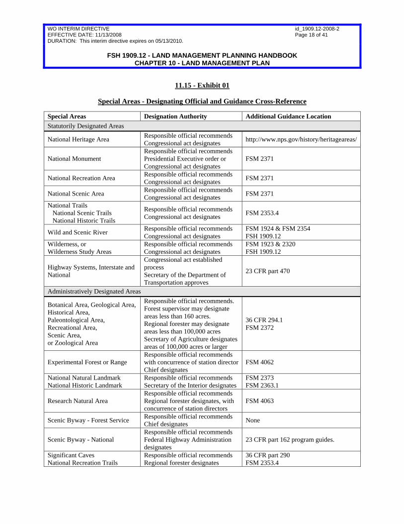
11.15 – Special Areas Special areas are places within the National Forest System identified or designated because of their unique or special characteristics (36 CFR 219.7(a)(2)(v)). The intent behind including special areas as a component in plans is not to develop new categories, but rather to assure that plans recognize existing categories Congress, the Department, or the Agency have established. Land management plans should recognize special areas that have been previously designated by statute or through a separate administrative process. Plans may also include special areas designated by the responsible official at the time of plan approval. Where a responsible official lacks authority to designate a special area, the official may recommend designation in the plan approval document. While recommended areas are not “special areas,” they can be identified in the plan as “management areas.” Exhibit 01 lists some areas that may be considered for special areas, the designating official, and the location of existing guidance for their designation. The list is not comprehensive; see FSM 2370 for further guidance on special areas and authorities. If a land area does not qualify as a special area, but needs specific guidance, the responsible official may identify the area as a management area or as a geographic area. If the plan development, plan amendment, or plan revision makes preliminary recommendations that ultimately will require Congressional action, the Washington Office must be notified. The responsible official, through the regional forester, must notify the Chief by letter of tentative preliminary administrative recommendations. Examples of preliminary recommendations for congressional action include additions to or deletions from the National Wilderness Preservation System, national trails, national recreation areas; and studies or changes to the National Wild and Scenic River System. For evaluation of areas for potential wilderness recommendations, see FSM 1923 and chapter 70 of this handbook. For evaluation of rivers for potential wild and scenic river recommendations, see FSM 1924 and chapter 80 of this handbook. A land management plan may establish guidance for special areas through the identification of desired conditions, objectives, suitable uses, guidelines, and standards for the area.
WO INTERIM DIRECTIVE EFFECTIVE DATE: 11/13/2008 DURATION: This interim directive expires on 05/13/2010.
id_1909.12-2008-2 Page 18 of 41
FSH 1909.12 - LAND MANAGEMENT PLANNING HANDBOOK
CHAPTER 10 - LAND MANAGEMENT PLAN
11.15 - Exhibit 01
Special Areas - Designating Official and Guidance Cross-Reference Special Areas Designation Authority Additional Guidance Location Statutorily Designated Areas
National Heritage Area Responsible official recommends Congressional act designates http://www.nps.gov/history/heritageareas/
National Monument Responsible official recommends Presidential Executive order or Congressional act designates
FSM 2371
National Recreation Area Responsible official recommends Congressional act designates FSM 2371
National Scenic Area Responsible official recommends Congressional act designates FSM 2371
National Trails National Scenic Trails National Historic Trails
Responsible official recommends Congressional act designates FSM 2353.4
Wild and Scenic River Responsible official recommends Congressional act designates
FSM 1924 & FSM 2354 FSH 1909.12
Wilderness, or Wilderness Study Areas
Responsible official recommends Congressional act designates
FSM 1923 & 2320 FSH 1909.12
Highway Systems, Interstate and National
Congressional act established process Secretary of the Department of Transportation approves
23 CFR part 470
Administratively Designated Areas
Botanical Area, Geological Area, Historical Area, Paleontological Area, Recreational Area, Scenic Area, or Zoological Area
Responsible official recommends. Forest supervisor may designate areas less than 160 acres. Regional forester may designate areas less than 100,000 acres Secretary of Agriculture designates areas of 100,000 acres or larger
36 CFR 294.1 FSM 2372
Experimental Forest or Range Responsible official recommends with concurrence of station director Chief designates
FSM 4062
National Natural Landmark National Historic Landmark
Responsible official recommends Secretary of the Interior designates
FSM 2373 FSM 2363.1
Research Natural Area Responsible official recommends Regional forester designates, with concurrence of station directors
FSM 4063
Scenic Byway - Forest Service Responsible official recommends Chief designates None
Scenic Byway - National Responsible official recommends Federal Highway Administration designates
23 CFR part 162 program guides.
Significant Caves National Recreation Trails
Responsible official recommends Regional forester designates
36 CFR part 290 FSM 2353.4

WO INTERIM DIRECTIVE EFFECTIVE DATE: 11/13/2008 DURATION: This interim directive expires on 05/13/2010.
id_1909.12-2008-2 Page 19 of 41
FSH 1909.12 - LAND MANAGEMENT PLANNING HANDBOOK
CHAPTER 10 - LAND MANAGEMENT PLAN
11.16 – Standards (Optional) A plan may contain standards. Standards should be included in a plan only when no other component will provide sufficient direction. “Standards are constraints upon project and activity decisionmaking and are explicitly identified in a plan as ‘standards.’ Standards are established to help achieve the desired conditions and objectives of a plan and to comply with applicable laws, regulations, Executive orders, and agency directives” (36 CFR 219.7(a)(3). A standard differs from a guideline in that a standard is a strict design criteria, allowing no variation, whereas a guideline allows variation if the result would be equally effective. See section 11.2 of this handbook for direction on project or activity consistency with plan components. Standards:
1. Place definitive technical design constraints on projects and activities using mandatory language, such as “must;”
2. Are stated in a way that clearly shows a connection between the standard and achieving or maintaining a desired condition;
3. Are written clearly and without ambiguity so that consistency of a project or activity with a standard can be easily determined;
4 Are written so that they are in accord with agency authorities, and the capability of the plan area;
5. Should not restate direction from other sources such as laws, regulations, and Forest Service directives, but may cite to other sources;
6. Should not direct or compel processes such as analysis, assessment, inventory, or monitoring; and
7. Must not restate desired conditions, objectives, suitability, guidelines, or other plan components.
Standards guide the design of projects and should not mandate conditions outside project areas. Any guidance meant to apply more broadly than to project areas, such as, “Open road density in XX watershed must average no more than 4 miles per square mile,” should be written in the form of desired conditions or objectives. Standards that require that certain conditions be met in a project area should provide for situations where those conditions do not currently exist in the area, such as, “When authorizing timber harvest, require the retention of an average of 4 snags per acre on forested acres. If fewer

WO INTERIM DIRECTIVE EFFECTIVE DATE: 11/13/2008 DURATION: This interim directive expires on 05/13/2010.
id_1909.12-2008-2 Page 20 of 41
FSH 1909.12 - LAND MANAGEMENT PLANNING HANDBOOK
CHAPTER 10 - LAND MANAGEMENT PLAN than 4 snags per acre on forested acres exist, require the retention of an average of 4 trees of the largest live trees per acre. The retained snags or live trees should not be distributed on every acre, but may occur in clumps throughout the project area.”
11.16a – Actions That Are Not Standards Standards do not include the following:
1. A final decision authorizing a project or activity, even if approved contemporaneously with the land management plan. An example of a decision that authorizes a project or activity includes: “The XXX project is hereby authorized.” This type of decision is a separate action that must independently comply with National Environmental Policy Act (NEPA).
2. Any public use prohibition. A plan provision guides agency action, but does not constrain public use unless an order is issued. Any constraint on the public’s use of the National Forest System, not otherwise imposed by law or regulation, requires the issuance of an order under 36 CFR part 261, subpart B. An example of such a order includes: “Mountain bicycles are prohibited in management area 4.”
It may be best to deal with these situations by identifying suitable land uses and establishing objectives to have use controlled in a specified time, such as managers expect to close management area 4 within one year of plan approval. Furthermore, while constraints on the public are not standards, the orders may be included in the plan as supplementary information.
Where an order is issued simultaneously with a plan, such order may be authorized in the plan approval document. The NEPA analysis for the order may be contemporaneous with the plan development analysis and is outside the scope of the planning categorical exclusion (36 CFR 220.6(e)(16))
3. Designation of roads, trails, and areas for motor vehicle use under 36 CFR 212.50 and enforcement of those designations under 36 CFR 261.13. Designations are project actions, not plan actions. Any environmental analysis necessary for proposed designations may be contemporaneous with the plan development analysis and reflected in the plan approval document or conducted and documented separately.
11.16b – New Standards to Be Approved As Part of Plan Development, Plan Amendment or Plan Revision Forest Service National Environmental Policy Act (NEPA) procedures are set forth in Title 36, Code of Federal Regulations, Part 220–National Environmental Policy Act (NEPA) Compliance (36 CFR part 220). It is Forest Service policy that establishing a new standard is outside the scope of the planning categorical exclusion (36 CFR 220.6(e)(16)).

WO INTERIM DIRECTIVE EFFECTIVE DATE: 11/13/2008 DURATION: This interim directive expires on 05/13/2010.
id_1909.12-2008-2 Page 21 of 41
FSH 1909.12 - LAND MANAGEMENT PLANNING HANDBOOK
CHAPTER 10 - LAND MANAGEMENT PLAN 11.16c – Retaining, Revising, or Removing Existing Standards During plan amendment or plan revision under the 2008 planning rule (36 CFR part 219), the responsible official must consider whether to retain, revise, or remove existing standards.
11.16d – Documenting Retaining and Revising Standards
1. Plan Approval Document and Required Evaluation Report. The plan approval document (36 CFR 219.7(c) will describe the extent to which standards from the existing plans are retained or revised. The required evaluation report will identify the decision document, or portion of such document, in which the standards were approved, and any prior environmental analysis which pertains to such standards.
2. NEPA Analysis. Typically, no further NEPA analysis is required at the time of plan amendment or revision for previously analyzed standards that are retained or revised.
3. Exceptions to Using the CE When Retaining or Revising Standards. If the responsible official proposes to retain existing or revised standards that command the Agency or others to undertake or refrain from undertaking projects and activities, such a proposal is outside the scope of the CE and shall be considered separately under Forest Service NEPA procedures, at which point the responsible official shall determine whether any previous environmental analysis pertaining to the retained or revised standards is adequate or whether it needs to be supplemented.
11.16e – Documenting Removing Standards
1. Evaluation Report. When standards are removed, the required evaluation report will identify which standards are removed and provide a rationale for the removal.
2. NEPA Analysis. Typically, no further NEPA analysis is required at the time of plan amendment or revision to remove standards.
3. Exceptions to Using the CE when Removing Standards. If the responsible official proposes to remove standards that may result in an immediate environmental impact because the removal would allow projects and activities to occur or require them to stop occurring without a subsequent proposed action by the Agency, such a proposal is outside the scope of the CE and shall be considered separately under Forest Service NEPA procedures.
11.2 – Project and Activity Consistency with the Plan The text in exhibit 01, Plan Consistency Template, must be included in a prominent location in the plan document. Recommended places are the beginning or in an appendix.

WO INTERIM DIRECTIVE EFFECTIVE DATE: 11/13/2008 DURATION: This interim directive expires on 05/13/2010.
id_1909.12-2008-2 Page 22 of 41
FSH 1909.12 - LAND MANAGEMENT PLANNING HANDBOOK
CHAPTER 10 - LAND MANAGEMENT PLAN
11.2 - Exhibit 01
Plan Consistency Template As required by NFMA and the planning rule, all projects and activities authorized by the Forest Service must be consistent with the plan (16 U.S.C. 1604(i); 36 CFR 219.8(a), (b), and (e)). Projects and activities cover all actions under 16 U.S.C. 1604(i). A project or activity must be consistent with the plan (36 CFR 219.8(e)) by being consistent with applicable plan components (36 CFR 219.7(a)); 36 CFR 219.8(a)). Plans may have other content, such as, background, collaboration strategies, context, existing conditions, glossary, introduction, monitoring questions, other referenced information or guidance, performance history, performance measures, performance risks, program emphasis, program guidance, program priorities, possible actions, roles and contributions, management challenges, or strategies, but such other content are not matters to which project consistency is required. Ensuring Project or Activity Consistency with the Plan—where a proposed project or activity would not be consistent with a plan component the responsible official has the following options:
1. To modify the proposal so that the project or activity will be consistent;
2. To reject the proposal; or
3. To amend the plan contemporaneously with the approval of the project or activity so that the project or activity is consistent with the plan as amended. The amendment may be limited to apply only to the project or activity (36 CFR 219.8(e)).
The following paragraphs describe how a project or activity is consistent with plan components and the requirements for documenting consistency. Desired conditions (36 CFR 219.7(a)(2)(i)) - Because of the many types of projects and activities that can occur over the life of a plan, it is not likely that a project or activity can maintain or contribute to the attainment of all desired conditions. Most projects and activities are developed specifically to maintain or move conditions toward one or more of the desired conditions of a plan. It should not be expected that each project or activity will contribute to all desired conditions in a plan, but usually to one or a subset. However, it should not be expected that in every instance, a project could clearly point to a specific desired condition as the reason the project was proposed; for example, a powerline right-of-way to a private inholding. There will also be instances when negative effects related to a specific desired condition are appropriate, either for long-term progress toward that same desired condition, or for progress toward or maintenance of another desired condition. It is also important that project consistency with a desired condition be assessed at the appropriate scale. For example, if a desired condition addresses watershed functionality at the scale of a 5th field watershed, then the contribution of any proposal to that desired condition should be considered at that scale.

WO INTERIM DIRECTIVE EFFECTIVE DATE: 11/13/2008 DURATION: This interim directive expires on 05/13/2010.
id_1909.12-2008-2 Page 23 of 41
FSH 1909.12 - LAND MANAGEMENT PLANNING HANDBOOK
CHAPTER 10 - LAND MANAGEMENT PLAN
11.2 - Exhibit 01--Continued
Plan Consistency Template To be consistent with the desired conditions of the plan, a project or activity, when assessed at the appropriate spatial scale described in the plan, must be designed to meet one or more of the following conditions:
1. Maintain or make progress toward one or more of the desired conditions of a plan without adversely affecting progress toward, or maintenance of other desired conditions, or
2. Be neutral with regard to progress toward plan desired conditions, or
3. Maintain or make progress toward one or more of the desired conditions over the long-term, even if the project or activity would adversely affect progress toward or maintenance of one or more desired conditions in the short-term, or
4. Maintain or make progress toward one or more of the desired conditions over the long-term, even if the project or activity would adversely affect progress toward other desired conditions in a negligible way over the long-term.
The project documentation should explain how the project is consistent with desired conditions and describe any short-term, or negligible long-term, adverse effects the project may have on the maintenance or attainment of any desired condition. Objectives (36 CFR 219.7(a)(2)(ii))— A project or activity is consistent with the objectives component of the plan if it contributes to or does not prevent the attainment of any applicable objectives. The project documentation should identify any applicable objective(s) to which the project contributes and document that the project does not prevent the attainment of any objectives. If there are no applicable objectives, the project is consistent with the objectives components of the plan, and the project documentation should state that fact.

WO INTERIM DIRECTIVE EFFECTIVE DATE: 11/13/2008 DURATION: This interim directive expires on 05/13/2010.
id_1909.12-2008-2 Page 24 of 41
FSH 1909.12 - LAND MANAGEMENT PLANNING HANDBOOK
CHAPTER 10 - LAND MANAGEMENT PLAN
11.2 - Exhibit 01--Continued
Plan Consistency Template Guidelines (36 CFR 219.7(a)(2)(iii))—A project or activity must be consistent with all guidelines applicable to the type of project or activity and its location in the plan area. A project or activity can be consistent with a guideline in either of two ways—
1. The project or activity is designed exactly in accord with the guideline, or
2. A project or activity design varies from the exact words of the guideline but is as effective in meeting the purpose of the guideline to contribute to the maintenance or attainment of relevant desired conditions and objectives.
The project documentation should describe how the project is consistent with the guidelines. When the project varies from the exact words of the guideline, the documentation must specifically explain how the project design is as effective in contributing to the maintenance or attainment of relevant desired conditions and objectives. Standards (36 CFR 219.7(a)(2)(v))—A project or activity is consistent with a standard if the project or activity is designed in exact accord with the standard. The project documentation should confirm that the project is consistent with applicable standards. Suitability of areas (36 CFR 219.7(a)(2)(iv))—A project with the purpose of timber production may only occur in an area identified as suitable for timber production (16 U.S.C. 1604(k)). The documentation for the project should confirm the project area meets the suitability for timber production criteria set out in FSH 1909.12 section 61. Except for projects with a purpose of timber production, a project or activity can be consistent with plan suitability determinations in either of two ways:
1. The project or activity is a use identified in the plan as generally suitable for the location where the project or activity is to occur, or
2. The project or activity is not a use identified in the plan as generally suitable for the location (the plan is silent on the use or the plan identifies the use as generally not suitable), but the responsible official determines that the use to be appropriate for that location’s desired conditions and objectives.
The project documentation should describe that the project or activity is either (1) a use for which the area is specifically identified in the plan as generally suitable, or (2) not a use for which the area is specifically identified in the plan as general suitable, but is nonetheless appropriate for that location. Special areas (36 CFR 219.7(a)(2)(v))—Where a plan provides plan components specific to a special area, a project, or activity must be consistent with those area-specific components. The project documentation should describe how the project or activity is consistent with the area-specific components of the plan.

WO INTERIM DIRECTIVE EFFECTIVE DATE: 11/13/2008 DURATION: This interim directive expires on 05/13/2010.
id_1909.12-2008-2 Page 25 of 41
FSH 1909.12 - LAND MANAGEMENT PLANNING HANDBOOK
CHAPTER 10 - LAND MANAGEMENT PLAN
11.3 – Possible Actions Place a list of the possible projects during the plan period in the land management plan to meet the intent of section 6(f)(2) of the National Forest Management Act (16 U.S.C. 1604(f)(2)), which states plans must “be embodied in appropriate written material, … reflecting proposed and possible actions, including the planned timber sale program and the proportion of timber harvest within the unit necessary to fulfill the plan.” The possible actions may be displayed in an appendix. A plan amendment is not required to change the list. The list may be presented as a brief summary of the types of possible projects expected to maintain or move toward the desired conditions in the next 3 to 5 years. In addition, the possible actions listed should include exhibits of the possible timber sale program where applicable; see examples of such exhibits in section 65 of this handbook. The plan’s discussion of possible actions must explicitly say that the type of actions described do not commit the Agency to perform that work, but are provided as possible actions “including the planned timber sale program and the proportion of probable methods of timber harvest within the unit necessary to fulfill the plan” (16 U.S.C. 1604(f)(2)). The identification of possible actions should not include speculation about the specific amount, frequency, location, magnitude, or quantities of actions during the plan period. Do not place program of work descriptions (a “to do” list of projects and expected dates) in the plan.
11.4 – Plan Guidance for Special Conditions or Situations The responsible official must provide plan components for special conditions or situations that involve hazards to the various resources (FSM 1921.12; 16 U.S.C. 1604(g)(2)(C)). Hazards considered should be reasonably foreseeable and not based on pure speculation. Examples of possible hazards may include the following: development of adjacent private land, floods, hurricanes, insects and disease, wind, and so on. To assure that plans provide for special conditions or situations involving hazards to the various resources, plan components should be developed by:
1. Using an interdisciplinary approach to coordinate multiple uses and to identify hazards and their relationships to activities;
2. Recognizing where ecological conditions are fragile or subject to major ecological disturbances;
3. Providing for ecological sustainability;
4. Using appropriate vegetation management systems; and
5. Using monitoring and evaluation to discontinue vegetation management systems that impair land productivity.
WO INTERIM DIRECTIVE EFFECTIVE DATE: 11/13/2008 DURATION: This interim directive expires on 05/13/2010.
id_1909.12-2008-2 Page 26 of 41
FSH 1909.12 - LAND MANAGEMENT PLANNING HANDBOOK
CHAPTER 10 - LAND MANAGEMENT PLAN 11.5 – Other Information Plans may include information other than the plan components, such as an explanatory narrative, general management principles, management approaches (defined in section 11.6), management challenges, referenced material, or roles and contributions. Other information must not be labeled or worded in a way that suggests it is a plan component. Also, other information must not include, nor appear to include, a “to do” list of tasks or actions.
11.6 – Management Approaches This optional section of a plan, if included, should briefly describe the principal management approaches the responsible official is inclined to take during the plan period. The approaches should come from and respond to the desired conditions and the objectives. They may convey a sense of priority and focus among objectives so that the public will know the likely management emphasis. For a few important programs, management approaches may indicate the future course or direction of change, recognizing past trends of budget and program accomplishments, without making precise estimates of quantities. This section may also describe partnership opportunities and collaboration arrangements that support the achievement of desired conditions and objectives. Management approaches may discuss potential processes such as analysis, assessment, inventory, or monitoring. This optional section must avoid making predictions or any statements that appear to be commitments or that may create unrealistic expectations among the public on the delivery of programs.
12 – MONITORING (See 36 CFR 219.6 and FSM 1921.5 for further direction. For evaluation of monitoring results, see FSM 1921.2 and section 24 of this handbook for further direction.) The plan must describe the monitoring program for the plan area. The monitoring program must provide for monitoring to help evaluate the effects of each managing system to the end that it will not produce substantial and permanent impairment of the productivity of the land and for monitoring the degree to which on-the-ground management is maintaining or making progress toward the plan’s desired conditions and objectives (36 CFR 219.6(b)(2)(ii)). The monitoring program should form the basis for continual improvement and adaptive management. The monitoring program sets out monitoring questions and associated performance measures. Every monitoring question must link to one or more desired condition. However, the monitoring program need not include a monitoring question for every desired condition, objective, guideline, or standard (sec. 12.1). Monitoring questions should focus on whether management within the plan area maintains or makes progress toward the desired conditions and should reference desired conditions directly or indirectly by focusing on objectives, guidelines, or standards. It is often helpful to pose two types of monitoring questions such as:
WO INTERIM DIRECTIVE EFFECTIVE DATE: 11/13/2008 DURATION: This interim directive expires on 05/13/2010.
id_1909.12-2008-2 Page 27 of 41
FSH 1909.12 - LAND MANAGEMENT PLANNING HANDBOOK
CHAPTER 10 - LAND MANAGEMENT PLAN
1. What are the status and trends of the relevant desired condition?
2. How effective have projects and activities been in achieving or maintaining the desired condition?
The responsible official must use an interdisciplinary approach and provide opportunities for the public to collaborate and participate in designing the program (36 CFR 219.9(a)). Joint monitoring with others should be considered and encouraged (36 CFR 219.6(b)(3)). A monitoring and evaluation framework is described in the “NFS LMP Monitoring and Evaluation Framework” available on the Agency Web site at http://www.fs.fed.us/emc/met/. Responsible officials should adopt the six themes of the NFS Land Management Plan Monitoring and Evaluation Framework and use the nine agency-priority sub-elements unless they are not applicable. Exhibit 01, Example of a Subset of a Monitoring Program for a Plan, identifies a sample subset of a possible unit-monitoring program that includes:
1. Monitoring questions,
2. Linkage to plan components, and
3. Performance measures associated with each question.

WO INTERIM DIRECTIVE EFFECTIVE DATE: 11/13/2008 DURATION: This interim directive expires on 05/13/2010.
id_1909.12-2008-2 Page 28 of 41
FSH 1909.12 - LAND MANAGEMENT PLANNING HANDBOOK
CHAPTER 10 - LAND MANAGEMENT PLAN
12 - Exhibit 01
Example of a Subset of a Monitoring Program for a Plan
Monitoring Question Linkage to Plan Components Performance MeasuresConservation and Maintenance of Soil, Water, and Air Resources
How are best management practices (BMPs) effective in protecting the most sensitive of the state-designated beneficial uses of surface water, namely that of native brook trout habitat?
Desired Condition: Surface water quality meets or exceeds state standards for aquatic biodiversity and beneficial downstream uses. Guideline: Project design should meet or exceed state BMPs to avoid nonpoint-source pollution.
Macroinvertebrate Aggregated Index for Streams score for benthic macroinvertebrates.
Conservation of Biological Diversity How are plant communities of alpine ecosystems being protected, maintained, and restored?
Desired Condition: Alpine ecosystems sustain their ecosystem diversity. They maintain the ecological attributes and processes that allow them to provide watershed values, habitat for native biota, panoramic vistas, and for solitude. They display a diverse composition of desirable native plant species and vegetation communities (including fellfield, turf, wetland, and dwarf willow types). Invasive plant species are absent or rare.
Areal extent of plant community of alpine ecosystems. Fragmentation characteristics such as patch size, edge, and proportion of habitat interior. Status of disturbance processes that shape the community.
Maintenance and Enhancement of Social Benefits How is information on forest recreation opportunities, rules and regulations, and user etiquette readily available and used by forest visitors?
Desired Condition Forest visitors are well informed about recreation opportunities and responsibilities, including which activities are allowed where, and how to be light-on-the-land.
Status and trend of contacts that result in providing visitors with information on opportunities and responsibilities.

WO INTERIM DIRECTIVE EFFECTIVE DATE: 11/13/2008 DURATION: This interim directive expires on 05/13/2010.
id_1909.12-2008-2 Page 29 of 41
FSH 1909.12 - LAND MANAGEMENT PLANNING HANDBOOK
CHAPTER 10 - LAND MANAGEMENT PLAN
12.1 – Selecting Monitoring Questions It is important to select the proper monitoring questions. Responsible officials should use a process to evaluate potential monitoring questions and select those that will provide the most useful information while also being practical and affordable. The selection process should take into account the best available science and may include, but is not limited to, consideration of the following factors:
1. Whether there is a great disparity between the existing and desired conditions. If the existing condition is near to or the same as the desired condition, monitoring resources may be best used elsewhere. It may be more valuable to monitor in situations where the difference between existing and desired condition is distinct. 2. Whether management activities are likely to affect the maintenance or achievement of a desired condition. It may be more valuable to monitor situations where possible projects and activities are expected to help maintain or reach toward the desired condition, rather than to monitor places where desired conditions would likely be maintained or achieved without active management. 3. Whether there is particular public interest in the maintenance or achievement in a specific desired condition. There may be more value in monitoring these desired conditions than others. 4. Whether there is a high degree of uncertainty associated with management assumptions used in the planning process. If there is not general agreement within the Agency, or with the public that potential future projects and activities will support certain desired conditions, it may be valuable to monitor these aspects of the plan. 5. Whether the question can be answered cost effectively. If the cost of answering the question is especially high given likely budget or staff capability constraints, the question might not be appropriate for the monitoring program. 6. Whether monitoring in partnership with other agencies or organizations may make feasible monitoring that would otherwise not be feasible. 7. Whether adequate performance measures can be identified; if not, the question is likely not appropriate for the plan monitoring program. 8. Whether the monitoring program has questions to assist in evaluating the effects of each managing system to the end that it will not produce substantial and permanent impairment of the productivity of the land.

WO INTERIM DIRECTIVE EFFECTIVE DATE: 11/13/2008 DURATION: This interim directive expires on 05/13/2010.
id_1909.12-2008-2 Page 30 of 41
FSH 1909.12 - LAND MANAGEMENT PLANNING HANDBOOK
CHAPTER 10 - LAND MANAGEMENT PLAN The responsible official must not only select proper questions but must also take care not to select more questions than the unit is capable of answering. The overall monitoring program should not be so large that the unit cannot do a creditable job of carrying it out.
12.2 – Performance Measures Performance measures are indicators, statistics, or metrics used to gauge program performance (FSM 1905) and answer the monitoring questions. Performance measures are a basis for accountability, both for near-term objectives and long-term desired conditions. The plan’s monitoring program should include one or more performance measures associated with each monitoring question. The responsible official should document the reason for selection of these performance measures in the plan set of documents. Responsible officials should pick measures that are affordable, practical, and useful for answering the monitoring questions of the plan area. Nevertheless, where possible, measures should be based on standardized data stored in Forest Service corporate data systems such as the Natural Resource Information System, or in other official sources from other public agencies (such as the Bureau of Census). Furthermore, measures should contribute to reporting progress toward Forest Service Strategic Plan goals and objectives (U.S. Department of Agriculture, Forest Service. 2007. USDA Forest Service Strategic Plan. FS-880. Washington. DC: U.S. Department of Agriculture, Forest Service 38 p. available at http://www.fs.fed.us/plan/). Consider coordinating the selection of performance measures with communities, non-governmental organizations, other agencies, regional foresters, station directors, States, Tribes, universities, or other parties to facilitate evaluating progress in sustainable resource management across all landownerships.
12.3 – Documents Associated with the Monitoring Program The monitoring program is described in the plan. Several other documents are associated with the monitoring program:
1. Monitoring Guide. A monitoring guide identifies:
a. The data to be collected and the specific methods for data collection;
b. Information about the data to be collected, or metadata;
c. How the data are stored;
d. Responsibilities for managing monitoring information;
e. The schedule of monitoring and evaluation activities during the planning period;

WO INTERIM DIRECTIVE EFFECTIVE DATE: 11/13/2008 DURATION: This interim directive expires on 05/13/2010.
id_1909.12-2008-2 Page 31 of 41
FSH 1909.12 - LAND MANAGEMENT PLANNING HANDBOOK
CHAPTER 10 - LAND MANAGEMENT PLAN
f. Cooperators and their roles with respect to particular monitoring items; and
g. Any applicable environmental management system (EMS) monitoring procedure associated with the land management plan.
2. Annual Monitoring Work Plan. An annual monitoring work plan should:
a. Be developed consistent with the monitoring guide, and
b. Identify the monitoring work expected for the upcoming fiscal year and the anticipated resources for carrying out the monitoring program.
3. Annual Evaluation Report. An annual evaluation report should:
a. Briefly summarize the monitoring activities conducted;
b. Evaluate the information obtained from the monitoring (to answer the associated monitoring question) (some evaluations may conclude that more monitoring data are needed); and
c. Make recommendations of needed action related to the plan (sec. 24 of this handbook).
4. Comprehensive Evaluation Report. A comprehensive evaluation report is required to develop or revise a plan and the responsible official must make it available to the public when the public notice for a proposed plan or plan revision is published in the Federal Register (36 CFR 219.9(b)(3)(ii)). The responsible official must involve the public in developing and updating the comprehensive evaluation report (36 CFR 219.9(a)). A comprehensive evaluation report must be updated at least every 5 years and should build from the monitoring and evaluation documented in the annual evaluation reports (sec. 24 of this handbook). Public notification of evaluation reports may be made in a way deemed appropriate by the responsible official (36 CFR 219.9(b)(2)(iii)). See section 24 of this handbook for further information.
13 - CONSIDERATION OF INDIVIDUAL RESOURCES Directions for considering certain resources in the planning process are found at specific chapters of FSM 1920 and this handbook as follows:
1. Requirements for integrating designated wilderness into the land management planning process are found in FSM 1923 and chapter 70 of this handbook;
2. Wild and scenic-river planning requirements are found in FSM 1924, and chapter 80 of this handbook;

WO INTERIM DIRECTIVE EFFECTIVE DATE: 11/13/2008 DURATION: This interim directive expires on 05/13/2010.
id_1909.12-2008-2 Page 32 of 41
FSH 1909.12 - LAND MANAGEMENT PLANNING HANDBOOK
CHAPTER 10 - LAND MANAGEMENT PLAN
3. Timber management planning requirements are found in FSM 1921.12, and chapter 60 of this handbook (timber sale program quantity is an objective); and
4. Social, economic, and ecological sustainability planning requirements are found in FSM 1921.7, and chapter 40 of this handbook.
13.1 – Resource Considerations Unless indicated otherwise in regulation, the responsible official identifies and selects the appropriate parameters for the evaluation and integration of resources into the unit’s plan set of documents based on relevant administrative unit-specific issues. All evaluations are based on the evaluation of new issues or new data since the last plan revision, including social, economic, and ecological conditions and best available science. When plans are developed or revised, do the following:
1. Evaluate sustainability within an area large enough to consider broad-scale social, economic, and ecological factors and trends over large landscapes. Selection of the area included in these evaluations must be guided by the issues being addressed, the extent of relevant ecosystems and their composition, structure and function, the ranges and habitats of individual species, or key social and economic patterns and processes. These landscapes may include several national forests and should consider non-National Forest System (NFS) lands. Evaluations for sustainability must extend to this larger area of analysis to understand the environmental context and opportunities and limitations for NFS lands to contribute to the sustainability of social, economic, and ecological systems. (FSM 1920.3, FSM 1927.7, FSH 1909.12, ch. 40).
2. Consider the potential for large-scale disturbances (such as fire, windstorms, floods, and insect or disease outbreaks) based on climate change trends and past historical trends in the plan area, and the possible effects of such disturbances on the achievement of plan objectives and desired conditions (sec. 43 of this handbook).
3. Consider the proximity, status, and threat of nonnative invasive species infestations to the presence and distribution of rare plant and animal communities in identifying lands as generally suitable for grazing (36 CFR 222.1), off-highway vehicle use, and dispersed recreation use (such as equestrian) (sec. 43 of this handbook).
4. Consider the current conditions and trends in the relationship among multiple-use desired conditions such as fuel conditions, recreation settings, recreation use, scenic quality, and vegetation.

WO INTERIM DIRECTIVE EFFECTIVE DATE: 11/13/2008 DURATION: This interim directive expires on 05/13/2010.
id_1909.12-2008-2 Page 33 of 41
FSH 1909.12 - LAND MANAGEMENT PLANNING HANDBOOK
CHAPTER 10 - LAND MANAGEMENT PLAN 13.11 – Physical Environment
13.11a – Paleontological Resources
1. Evaluation. When paleontological resources are relevant issues in the planning process, the responsible official should:
a. Consider the geologic unit or area’s potential to yield fossils of scientific, educational, and interpretive value; and
b. Consider any area’s potential to be open to the public for visits and interpretative services.
2. Plan Components. When developing, amending, or revising a plan component for paleontological resources consider the following:
a. Establishing desired conditions for maintenance of paleontological resources, objectives for use of paleontological resources (for example interpretation, public education, or research), and guidelines to constraint projects and activities to protect paleontological resources, if appropriate; and
b. Establishing desired conditions and objectives to preserve the integrity and special qualities of the paleontological resources within the plan area.
13.11b – Air Management
1. Evaluation. When air management is a relevant issue in the planning process, the responsible official should at the airshed scale:
a. Acknowledge the location and extent of known sensitive air quality areas, such as Class I areas, non-attainment areas, and air quality maintenance areas;
b. Consider if air resources need additional plan components for visibility and other air quality related values protection or Clean Air Act compliance;
c. Consistent with FSM 2580, identify the options available to support the States’ or tribes’ implementation plan (SIP/TIP) for regional haze and non-attainment areas (especially the option of including Forest Service emission estimates in the appropriate SIP/TIP); and
d. Identify current inventories of airshed conditions using existing information including that from States, tribes, and regional planning organizations in the plan set of documents.
WO INTERIM DIRECTIVE EFFECTIVE DATE: 11/13/2008 DURATION: This interim directive expires on 05/13/2010.
id_1909.12-2008-2 Page 34 of 41
FSH 1909.12 - LAND MANAGEMENT PLANNING HANDBOOK
CHAPTER 10 - LAND MANAGEMENT PLAN
2. Plan Components. When developing, amending, or revising a plan component for air management, consider establishing desired conditions for the following:
a. Resources affected by air pollution, for example: flora, fauna, visibility, soils, water, and so forth;
b. Air quality (as measured by pollutant concentration) as it affects public health and safety; and
c. High value air resources in the plan area such as Class I areas where poor air quality or visibility would be likely to adversely affect visitor experience, public health, or dependent resources.
13.11c – Water
1. Evaluation. When water management is a relevant issue in the planning process, the responsible official should, at the 8-digit or 10-digit hydrologic unit code watershed scale:
a. Acknowledge the location and extent of known ground-water resources and ground water-dependent ecosystems such as cave and karstic systems, cold-water streams and lakes, fens, riparian areas, seeps, springs, and wetlands;
b. Consider whether water resources with water quantity, quality, or timing issues need additional plan components for contributing to sustainability of aquatic ecosystem diversity (sec. 43 of this handbook) and existing human uses;
c. Identify the methodology used to identify the unit’s nonconsumptive water needs, and the options available for additional plan components to support the State’s water allocation process only when demand for NFS water is high, consistent with FSM 2540; and
d. Identify current inventories of watershed restoration needs, including the Clean Water Act Section 303(d) and Section 305(b) listed waters (33 U.S.C. 1313(d), 1314(b)).
2. Plan Components. When developing, amending, or revising a plan component for water management consider establishing desired conditions for the following:
a. Surface and ground-water resources, including water-dependent ecosystem diversity;
b. Water quality (36 CFR 219.12(b)(4), FSM 1921.12; FSM 1921.7); and

WO INTERIM DIRECTIVE EFFECTIVE DATE: 11/13/2008 DURATION: This interim directive expires on 05/13/2010.
id_1909.12-2008-2 Page 35 of 41
FSH 1909.12 - LAND MANAGEMENT PLANNING HANDBOOK
CHAPTER 10 - LAND MANAGEMENT PLAN
c. High value aquatic resources in the plan area such as aquifers, bogs, fens, karstic areas, seeps, or wetlands where flow diversions or poor water quality would be likely to adversely affect dependent resources.
13.11d – Soil
1. Evaluation. When soil management is a relevant issue in the planning process, the responsible official should at the landtype association scale:
a. Evaluate soil quality for its ability to sustain ecological function to sustain the land’s ability to provide goods and ecological services in perpetuity.
b. Identify current inventories of soil quality and improvement needs in the plan set of documents.
2. Plan Components. When developing, amending, or revising a plan component for soil management, consider establishing desired conditions for soil physical, chemical, and biological qualities as they sustain the productive capacity of the land, its ecological resources, and the hydrological function of watersheds.
13.12 – Biological Environment
13.12a – Fire and Fuels Management
1. Evaluation. When fire and fuels management are relevant issues in the planning process, the responsible official should take the following steps for analysis:
a. Identify fire’s historic role in the plan area;
b. Identify trends in fire behavior, fire suppression costs, and associated vegetation trends, considering climate change as appropriate;
c. Identify fire’s potential future role in the plan area as a context for plan components, based on the information obtained in steps a and b above;
d. Identify wildland urban interface areas and review existing local community wildfire protection plans; and
e. Identify current vegetation and natural disturbance processes.
2. Management Approaches. The management approaches section of the plan may identify factors to consider when establishing fire management priorities (sec. 11.6). Fire management priorities may concern allocation of fire suppression resources in multiple-fire situations, identification of fuels management priorities, post-fire rehabilitation, fire prevention, and fire preparedness.

WO INTERIM DIRECTIVE EFFECTIVE DATE: 11/13/2008 DURATION: This interim directive expires on 05/13/2010.
id_1909.12-2008-2 Page 36 of 41
FSH 1909.12 - LAND MANAGEMENT PLANNING HANDBOOK
CHAPTER 10 - LAND MANAGEMENT PLAN
3. Plan Components. When developing, amending, or revising a plan, fire or fuels management should be considered as appropriate and as follows:
a. Desired Conditions. Development of desired conditions and objectives for land and resources of the plan area should integrate fire with the other outcomes for social, economic, and ecological attributes and take into account the information obtained in the evaluation analysis. In addition, the following topics should be considered: current management strategies, public and firefighter safety, urban interface, appropriate management response, smoke management, hazardous fuels, and prevention.
b. Objectives. Where fuels conditions are an issue, and a desired condition for fuels has been identified, the plan should include a plan objective that sets forth a projection of the number of acres by treatment outcome in a specific time to move toward (or maintain) the desired condition.
c. Suitable Uses. Fire responses or fuels treatment tools should not be included in the "suitable uses" component, unless to do so would contribute to the collaborative planning process. (A guideline or standard may be used to provide guidance on when or how a specific tool is appropriate.)
d. Standards. The plan may include standards for fire and fuels management.
e. Guidelines. The plan may include guidelines related to wildland fire responses, prescribed fire treatments, non-fire fuels treatments, and post-fire rehabilitation.
(1) Guidelines for prescribed fire, non-fire fuels treatments, and post-fire rehabilitation may be established, in accord with the general direction at section 11.13.
(2) Guidelines for fire responses must avoid even the appearance of deciding the responses to wildland fire. Guidelines may indicate actions that may be considered, or the conditions to consider in choosing a response, or the manner in which a response should be carried out such that purposes of natural resource management, protection of life, property, and public safety are met.
4. Examples of Plan Components. The following is a list of appropriate desired conditions, inappropriate guidelines, and appropriate guidelines for fire response.
a. Appropriate desired conditions:
(1) In management area 4, fuel conditions are such that the entire area including lands suitable for timber production can tolerate wildland fire.

WO INTERIM DIRECTIVE EFFECTIVE DATE: 11/13/2008 DURATION: This interim directive expires on 05/13/2010.
id_1909.12-2008-2 Page 37 of 41
FSH 1909.12 - LAND MANAGEMENT PLANNING HANDBOOK
CHAPTER 10 - LAND MANAGEMENT PLAN
(2) In this wildland urban interface, fuel loadings are low, firefighters are able to safely and efficiently undertake any appropriate management response, and the area can safely tolerate wildland fire on adjacent lands.
b. Inappropriate guideline – recommendation to “use” a tactic as an appropriate response: In management area 4, because of the proximity to wildland urban interface, perimeter control “should be used as the” appropriate management response to unplanned ignitions.
c. Appropriate guideline – recommendation to “consider” a tactic as an appropriate response: In management area 4, because of the proximity to wildland urban interface, perimeter control “should be considered as an” appropriate management response to unplanned ignitions.
d. Appropriate guideline – conditions to consider when choosing a response. In management area 4, consider the proximity to wildland urban interface in selecting a response to unplanned ignitions.
e. Appropriate guideline – to consider alternative actions: In the Blue Tree Wilderness, when the risk of extreme fire behavior is low, consider “point protection based on values at risk,” “wildland fire use,” or “monitoring of the fire” in selecting a response to unplanned ignition.
f. Appropriate guidelines – limitation on the way (not the choice) of response:
(1) Mechanical firelines should not be constructed on erosive X, Y, and Z type soils nor on slopes greater than 30 percent.
(2) In the Rocky Gorge management area, when perimeter control is the response to wildfire, natural barriers should be used as firelines.
(3) Fire camps staging areas, helibases, and airstrips should be located on lands that:
(a) Are not forested;
(b) Are adjacent to a well-maintained forest road (36 CFR 212.1);
(c) Have less than 5 percent slope; and
(d) Are 100 feet or more from all bodies of water, wetlands, and trails.
13.12b – Large Fire Cost Containment During plan development, plan amendment, or plan revision, responsible officials with management units where large fires have historically occurred or have the potential to occur resulting in costly fire suppression should consider wildland fire cost containment as follows—
WO INTERIM DIRECTIVE EFFECTIVE DATE: 11/13/2008 DURATION: This interim directive expires on 05/13/2010.
id_1909.12-2008-2 Page 38 of 41
FSH 1909.12 - LAND MANAGEMENT PLANNING HANDBOOK
CHAPTER 10 - LAND MANAGEMENT PLAN
1. Establish plan components that set forth appropriate information for the wildland fire decision support systems to contain costs; and
2. Establish plan components that guide appropriate management responses to large fires (See examples in sec. 12.12a.)
13.12c – Wildlife and Fisheries (See FSM 1921.7; and FSH 1909.12, sec. 43.)
13.13 – Social and Economic Environment
13.13a – Recreation and Scenery Management When recreation or scenery management is a relevant issue in the planning process, the responsible official should—
1. Use the recreation opportunity spectrum (ROS) and the scenery management system (SMS) to describe recreational desired conditions and objectives. A plan area need not provide recreation opportunities in each ROS class or scenic integrity level;
2. Consider the current condition and trends of visitation to the plan area to evaluate if the plan provisions for quality recreation and tourism experience for the plan area are adequate;
3. Establish recreational opportunities, such as hunting, fishing, skiing, hiking, and scenery viewing on plan areas as desired conditions in plans where these experiences contribute to the local economies of NFS land-dependent rural communities; and
4. Consider the relationship between potential wilderness values and other desired conditions, such as fuel reduction, recreation, wildlife, and vegetation, if determining management guidance for a potential wilderness.
The following resource integration analytical tools are available.
1. Recreational Settings and Opportunities Issues. Recreation Opportunity Spectrum (ROS) system. This system is described in FSM 2311 and the 1986 ROS Book.
2. Scenery issues. Landscape Aesthetics - A Handbook for Scenery Management (Agricultural Handbook Number 701). Also, see FSM 2380.61 for landscape aesthetics guidance.

WO INTERIM DIRECTIVE EFFECTIVE DATE: 11/13/2008 DURATION: This interim directive expires on 05/13/2010.
id_1909.12-2008-2 Page 39 of 41
FSH 1909.12 - LAND MANAGEMENT PLANNING HANDBOOK
CHAPTER 10 - LAND MANAGEMENT PLAN 13.13b – Cultural Resources
1. Evaluation. When cultural resources are relevant issues in the planning process, the responsible official should—
a. Consider cultural resource information for crucial data and insights into the past that have a bearing on sustainability of NFS lands and resources; and
b. Coordinate the evaluation of the need to change heritage plan provision in the current plan with the state historic preservation officer (SHPO), Indian tribes, local governments, and other interested parties as appropriate (See FSM 2360).
2. Plan Components. When developing, amending, or revising a plan component for cultural resources, historic properties, or priority heritage assets consider the following—
a. Establishing desired conditions for maintenance of cultural resources, objectives for use of cultural resources (for example, public education, interpretation, traditional use, or research), and guidelines to constraint projects and activities to protect cultural resources, if appropriate;
b. Establishing desired conditions and objectives to preserve the integrity and special qualities of the cultural resources and their settings (FSM 2360); and
c. Establishing objectives to protect the plan area’s most significant cultural sites. (For example, to reduce fuel density to provide defensible space for 10 priority heritage sites by 2015.)
13.13c – Minerals including Energy Minerals When minerals including energy minerals are relevant issues in the planning process, the responsible official may—
1. Establish desired conditions and objectives related to the protection of surface resources that may be affected by development of minerals resources;
2. Establish guidelines (or where appropriate, standards) to guide mineral development;
3. Recognize exploration and development represents a relatively short-term use and, with proper design and reclamation practices, usually does not appreciably diminish long-term productivity of the lands or preclude attainment of long-term objectives for surface resources;
4. Recognize mineral development can be important to local economies and can contribute to national security. Therefore, some residual impacts may often be considered acceptable given the benefits obtained;

WO INTERIM DIRECTIVE EFFECTIVE DATE: 11/13/2008 DURATION: This interim directive expires on 05/13/2010.
id_1909.12-2008-2 Page 40 of 41
FSH 1909.12 - LAND MANAGEMENT PLANNING HANDBOOK
CHAPTER 10 - LAND MANAGEMENT PLAN
5. Recognize valuable mineral resources are relatively rare in nature, occur in very discrete and specific areas, and large amounts of land may be needed for exploration if discoveries are to be made;
6. Recognize where trade-offs must be made to accommodate minerals and competing resource programs, choices should consider existing mineral rights as well as the potential short, and long-term environmental, social, and economic costs and benefits; and
7. Recognize that plan components that deal with minerals must be consistent with current public laws and Federal regulations, such as coal leasing (43 CFR part 4325), geothermal resource leasing (43 CFR part 3200), locatable minerals (36 CFR part 228, subpart A), mineral materials (36 CFR part 228, subpart C), and oil and gas leasing (36 CFR part 228 subpart E).
13.13d – Range Management When range management (FSM 2200) is a relevant issue in the planning process, the responsible official should recognize that wild horse-burro territory boundaries are among the relevant range issues in plans (FSM 2260). These boundaries typically overlap allotment boundaries and possibly other administrative boundaries.
13.13e – Access, Roads, Trails, or Travel Management When access, roads, trails, or travel management are relevant issues in the planning process, the responsible official should—
1. Recognize valid existing rights of access including outstanding and reserved valid existing rights.
2. Recognize project and activity decisions such as road construction or designation of roads for motor vehicle use under Title 36, Code of Federal Regulations, section 212.51 are not plan components and not normally part of plan development, plan amendment, or plan revision;
3. Evaluate the need to change existing plan provisions for natural and cultural resources, public safety, recreational opportunities, and access and travel management;
4. Integrate considerations of biological, physical, social, and economic factors and environmental design arts into the plan components;
5. Ensure that desired conditions for access and travel management have been established for all NFS lands within the plan area (36 CFR part 212, FSM 7710); and

WO INTERIM DIRECTIVE EFFECTIVE DATE: 11/13/2008 DURATION: This interim directive expires on 05/13/2010.
id_1909.12-2008-2 Page 41 of 41
FSH 1909.12 - LAND MANAGEMENT PLANNING HANDBOOK
CHAPTER 10 - LAND MANAGEMENT PLAN
6. Integrate the determination of the minimum road system with the land management plan under Title 36, Code of Federal Regulations, section 212.5(b) and FSM 7710.3, after consideration of the forest-scale roads analysis conforming to FSM 7710. The minimum road system determined to be needed to meet desired conditions and objectives in the plan is documented in the applicable forest transportation atlas or a road atlas (36 CFR 212.2(b); FSM 7711).
13.13f – Land Use and Special Uses When land use and special uses are relevant issues in the planning process, the responsible official should—
1. Evaluate lands to identify whether they should be generally available for disposal or whether coordinated management is important and acquisition may be appropriate, and consider how disposal or acquisition may affect the land use strategy or economy of the county in which lands are located. In evaluating whether lands are desirable for acquisition, consider the distribution, range, and habitat of specific threatened and endangered species and species-of-concern, including critical habitat under the Endangered Species Act and location of significant historical or cultural resources.
2. Identify lands generally available for disposal or desirable to acquire.
3. Consider transportation corridor and utility corridor designation and appropriate plan provisions. Coordinate evaluation of plan provisions between regions and with other Federal and State agencies and Tribes to designate location, alignment, and associated use and occupancy mitigation measures for corridors.
4. Incorporate the designated energy right-of-way corridors on Federal land in the plan in accordance with section 368 of the Energy Policy Act of 2005 (Title 42, United States Code, section 15926 (42 U.S.C. 15926).
5. Consider plan provisions for geothermal leasing and development for areas with high geothermal resource potential in accord with section 4 of the Geothermal Steam Act as amended by section 222 of the Energy Policy Act of 2005 (30 U.S.C. 1003(d)).
Washington Office (WO) notice is required, if the plan development, plan amendment, or plan revision makes preliminary recommendations for proposed adjustments in national forest, grassland, prairie, or other comparable administrative unit’s boundaries. WO notice is required because ultimately such an action would require Congressional action. The responsible official, through the regional forester, must notify the Chief by letter of any such tentative preliminary administrative recommendations.