frontogenesis, cyclones & anticyclones and jetstreams 1&2
TRANSCRIPT

Frontogenesis,Cyclones & Anticyclones and Jetstreams – 1&2
By Sudarshan Gurjar

Current Events-Climatology

Typhoon Hagibis
➢Why in News = Typhoon Hagibis caused flooding and
landslides as it reached Japan.
➢About
• Typhoon Hagibis could be the strongest storm to hit Japansince 1958.
• Typhoon Hagibis, which means “speed” in the Philippinelanguage, had packing winds of 180 km per hour near itscentre.
• The storm brought record-breaking rainfall to many areas,resulting in floods and landslides in the country.

Cyclone Maha
➢Why in News = A depression that developed in the Comorin Sea (near thesouthernmost end of India) has intensified into a cyclonic storm, named ‘Maha’
➢About
• The name has been given by Oman.
• It lies centered over Lakshadweep and the adjoining
southeast Arabian Sea and the Maldives area.
• Cyclone storm ‘Maha’ is the second in the 2019
northeast monsoon season, following close on the
heels of super cyclone Kyarr which took its way
towards the Arabian peninsula.

Cyclone Bulbul
➢Why in News = The India Meteorological Department (IMD) has issued an
orange alert in Indian states of West Bengal and Odisha over Cyclone Bulbul in theBay of Bengal.
➢About
• The depression over the east-central and southeastBay of Bengal and North Andaman Sea has turnedinto a severe cyclonic storm.
• The landfall of the cyclone is expected betweenSagar Islands (WestBengal) and Khepupara(Bangladesh).
• The cyclone has been named by Pakistan.
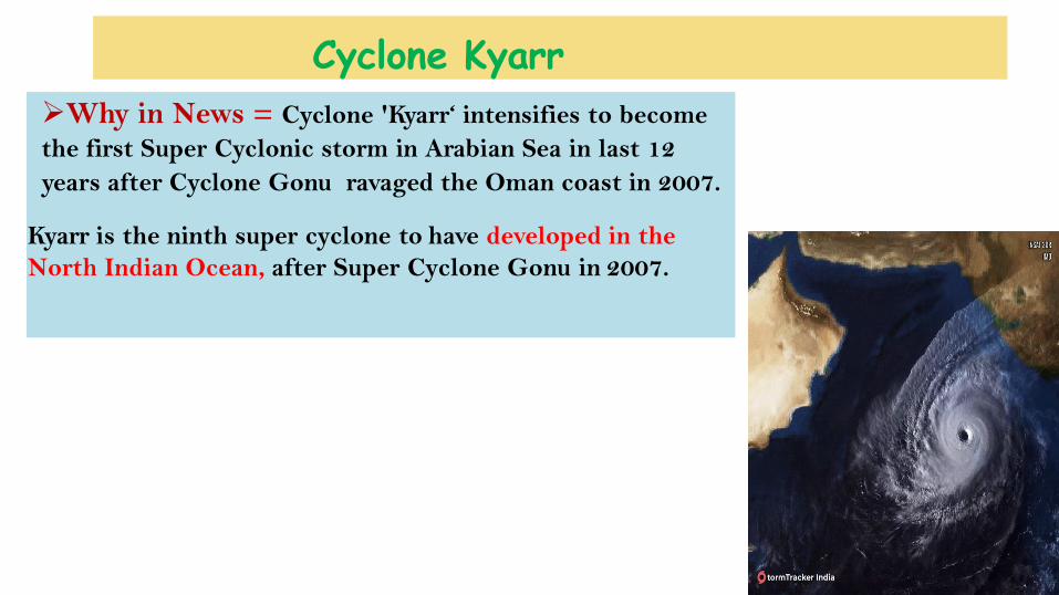
Cyclone Kyarr
➢Why in News = Cyclone 'Kyarr‘ intensifies to become
the first Super Cyclonic storm in Arabian Sea in last 12
years after Cyclone Gonu ravaged the Oman coast in 2007.
Kyarr is the ninth super cyclone to have developed in the
North Indian Ocean, after Super Cyclone Gonu in 2007.
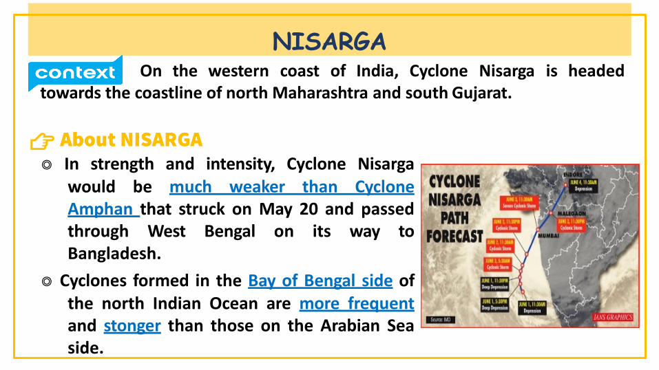
NISARGAOn the western coast of India, Cyclone Nisarga is headed
towards the coastline of north Maharashtra and south Gujarat.
👉◎ In strength and intensity, Cyclone Nisarga
would be much weaker than CycloneAmphan that struck on May 20 and passedthrough West Bengal on its way toBangladesh.
◎ Cyclones formed in the Bay of Bengal side ofthe north Indian Ocean are more frequentand stonger than those on the Arabian Seaside.

◎ The relatively cold waters of the Arabian Sea discourage the kind of verystrong cyclones that are formed on the Bay of Bengal side; Odisha andAndhra Pradesh face the brunt of these cyclones every year.
NISARGA
Cyclone AmphanThe India Meteorological Department (IMD) has declared a
cyclone alert for the Indian coastline across the Bay of Bengal as a low-pressure area has formed over southeast Bay of Bengal and adjoining southAndaman sea. The cyclone will be named ‘CycloneAmphan’.
👉
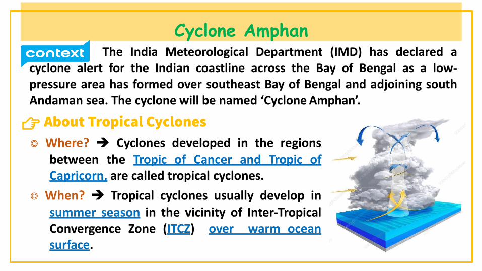
◎ Where? ➔ Cyclones developed in the regionsbetween the Tropic of Cancer and Tropic ofCapricorn, are called tropical cyclones.
◎ When? ➔ Tropical cyclones usually develop insummer season in the vicinity of Inter-TropicalConvergence Zone (ITCZ) over warm oceansurface.

◎ Redistributed of heat ➔ Tropical cyclones are one of the mechanisms by which surface heat energy is redistributed from the equator to the poles.
◎ Conditions necessary for development➔○ Large sea surface with temperature higher than 27° C○ Presence of the Coriolis force○ Small differences in the vertical wind speed○ A pre-existing weak- low-pressure area or low-level-cyclonic circulation○ Upper divergence above the sea level system
Cyclone Amphan

Heatwave
India Meteorological Department (IMD) has issued a redwarning for Delhi, Punjab, Haryana, Chandigarh and Rajasthan for the nexttwo days.
👉
◎ What is it? ➔ It is a period of abnormally hightemperatures more than the normal maximumtemperature that occurs during the summerseason in the North-Western and SouthCentral parts of India.
◎ Time of occurrence ➔ They typically occurbetween March and June and in some rarecases even extend till July.
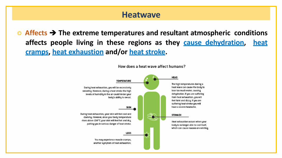
◎ Affects ➔ The extreme temperatures and resultant atmospheric conditionsaffects people living in these regions as they cause dehydration, heatcramps, heat exhaustion and/or heat stroke.
Heatwave

◎ Criteria ➔ The Indian Meteorological Department (IMD) has given the following criteria for Heat Waves:
Heatwave

◎ Alerts for Heat Waves by IMD ➔
Heatwave


• Western Europe’s weather is largely governed by the jet stream. This high-altitude, high-velocity river of air meanders around the globe and is constantly changing position.
• When an omega-shaped wave is present on the jet stream which arcs over Europe,warm dry air from southern Europe and Africa can be pulled north, pushing temperatures higher than normal.
• If this upper level feature coincides with high pressure at the surface with relatively low pressure to the east and west an omega block is formed.
• This pattern of flow can be very persistent and lead to long periods of fine
weather in summer.
OMEGA BLOCK

• Decreased cloud cover and transport of warm air over a number of days can produce very high temperatures. Such a situation occurred last week, replacing the usually cool westerly air stream with warm air from over continental Europe.
• An important consequence of this situation has been the formation of a Spanish plume, which transports warm dry air from over Spain to the UK.
OMEGA BLOCK
BySudarshan Gurjar

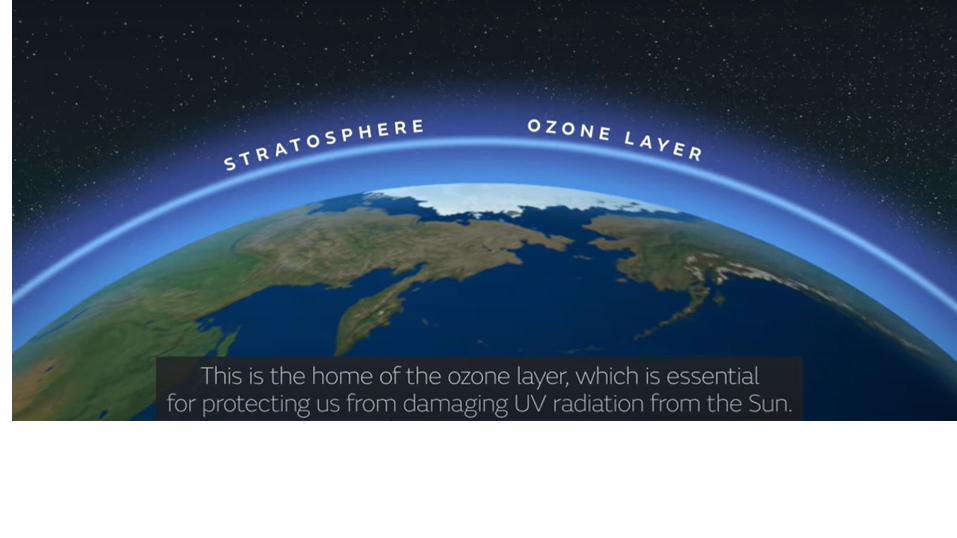
Sudden Stratospheric Warming Record warm temperatures occurred above Antarctica in a phenomenon called "sudden stratospheric warming".


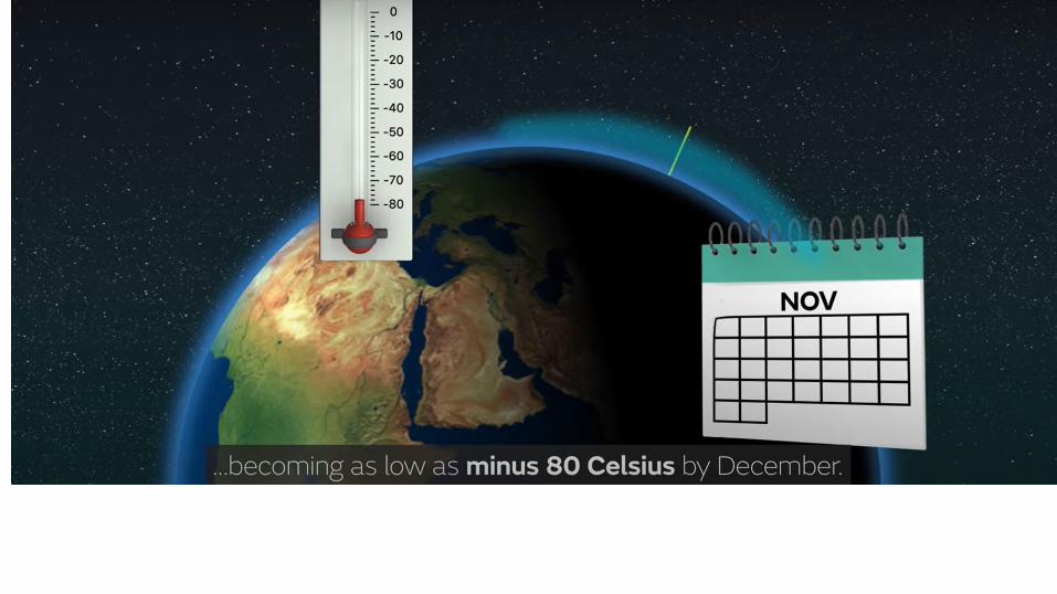


• In sudden stratospheric warming, the stratosphere high above the South Polebegan rapidly heating.• Every winter, westerly winds, often up to 200 km/hour, develop in thestratosphere high above the South Pole and circle the polar region.• The winds develop as a result of the difference in temperature over the pole(where there is no sunlight) and the Southern Ocean (where the sun still shines).• As the sun shifts southward during spring, the polar region starts to warm.

This warming causes the stratospheric vortex and associated westerly winds togradually weaken over the period of a few months.• However, in some years this breakdown can happen faster than usual.• Waves of air from the lower atmosphere (from large weather systems or flow
over mountains) warm the stratosphere above the South Pole.• This weakens or "mix" the high-speed westerly winds.• Very rarely, if the waves are strong enough they can rapidly break down the polar
vortex, actually reversing the direction of the winds so they become easterly.

• Apart from warming the Antarctic region, the most notable effect of thephenomenon will be a shift of the Southern Ocean westerly winds towards theEquator.• Tasmania, New Zealand's South Island, and Patagonia directly in the path of thestrongest westerlies results in more storminess and rainfall, and colder temperatures.• Subtropical Australia, which largely sits north of the main belt of westerlies, receivesreduced rainfall, clearer skies, and warmer temperatures.

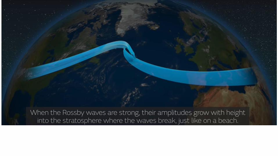
The weather system causing the rapid rise of stratospheric temperatures also lead to weakening of the Antarctic polar vortex, a slowly-spinning pool of stratospheric air trapped by a ring of fierce westerly winds—the polar night jet—that emerges in the upper stratosphere during winter at the South Pole.
The breakdown of the polar vortex helped the ozone hole in two ways. The early season warmth minimized further formation and persistence ofpolar stratospheric clouds. Because these clouds enable the chemistry that produces ozone-destroying substances, fewer clouds meant less ozonedestruction .The weak polar vortex also allowed more ozone-rich air from lower latitudes of the Southern Hemisphere to mix into the polarstratosphere and partially patch the hole that had begun to form. The lingering warmth prevented it from reforming.This is the third time in the last 40 years that weather systems have caused warm temperatures that limit ozone depletion. Similar weather patternsin the Antarctic stratosphere in September 1988 and 2002 also produced atypically small ozone holes


Air Masses
By Sudarshan Gurjar
When the air remains over a homogenous area for a sufficiently longer time, itacquires the characteristics of the area. The homogenous regions can be the vastocean surface or vast plains and plateaus.
The air with distinctive characteristics in terms of temperature and humidity iscalled an air mass. It is a large body of air having little horizontal variation intemperature and moisture.
Air masses form an integral part of the global planetary wind system. Therefore,they are associated with one or other wind belt.
They extend from surface to lower stratosphere and are across thousands ofkilometers.

Conditions for the formation of Air masses
•Source region should be extensive with gentle, divergent air circulation (slightly at high pressure).
•Areas with high pressure but little pressure difference or pressure gradient are ideal source regions.
•There are no major source regions in the mid-latitudes as these regions are dominated by cyclonic and other disturbances
By Sudarshan Gurjar

Source regions
By Sudarshan Gurjar
The homogenous surfaces, over which air masses form, are called the source regions.
The main source regions are the high pressure belts in the sub tropics (giving rise to tropical air masses) and around the poles (the source for polar air masses).
Source Region establishes heat and moisture equilibrium with the overlying air mass.
When an air mass moves away from a source region, the upper level maintains the physical characteristics for a longer period.
This is possible because air masses are stable with stagnant air which do not facilitate convection. Conduction and radiation in such stagnant air is not effective.

Source regions
By Sudarshan Gurjar
Accordingly, following types of airmasses are recognised:
Maritime tropical (mT);
Continental tropical (cT);
Maritime polar (mP);
Continental polar (cP);
Continental arctic (cA).

By Sudarshan Gurjar

Fronts are the typical features of midlatitudes weather (temperate region- 30° – 65° N and S).
They are uncommon (unusual) in tropical and polar regions.
Front is a three dimensional boundary zone formed between two converging air masses with different physical properties (temperature, humidity, density etc.).
By Sudarshan Gurjar

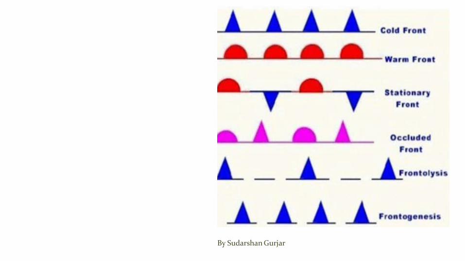
Front Formation The process of formation of a front is known as Frontogenesis (war
between two air masses) and dissipation of a front is known as Frontolysis (one of the air masses win against the other).
Frontogenesis involves convergence of two distinct airmasses.
Frontolysis involves overriding of one of the air mass by another.
Mid-latitude cyclones or temperate cyclones or extra-tropical cyclonesoccur due to frontogenesis.
By Sudarshan Gurjar

By Sudarshan Gurjar

Based on the mechanism of frontogenesis and the associatedweather, the fronts can be studied under the following types.
Stationary Front
By Sudarshan Gurjar

Stationary Front Weather along a stationary front
When the surface position of a front does not change (when two air masses are unable to push against each other; a draw), a stationary front is formed.
The wind motion on both sides of the front is parallel to the front.
Once this boundary resumes its forward motion, becomes a warmfront or cold front.
By Sudarshan Gurjar

Cold Front Such a front is formed when a cold air mass replaces a warm air mass by
advancing into it or that the warm air mass retreats and cold air mass advances (cold air mass is the clear winner).
In such a situation, the transition zone between the two is a cold front.
Cold front moves up to twice as quickly as warm fronts.
Frontolysis begin when the warm air mass is completely uplifted by the cold air mass.
By Sudarshan Gurjar

Weather along a Cold Front The weather along such a front depends on a narrow band of cloudiness and
precipitation.
Severe storms can occur. During the summer months thunderstorms are common in warm sector.
Produce sharper changes in weather.
.
By Sudarshan Gurjar

By Sudarshan Gurjar

Cloud Formation along a Cold Front The approach of a cold front is marked by increased wind activity in warm
sector and the appearance of cirrus clouds, followed by lower, denser altocumulous and
At actual front, dark nimbus and cumulonimbus clouds cause heavyshowers.
A cold front passes off rapidly but the weather along it is violent.
By Sudarshan Gurjar

By Sudarshan Gurjar

By Sudarshan Gurjar

Warm Front It is a sloping frontal surface along which active movement of warm air over
cold air takes place (warm air mass is too weak to beat the cold air mass).
Frontolysis (front dissipation) begin when the warm air mass makes way for cold air mass on the ground, i.e. when the warm air mass completely sits over the cold air mass.
By Sudarshan Gurjar

Weather along a Warm Front As the warm air moves up the slope it condenses and causes precipitation
but, unlike a cold front the temperature and wind direction changesare gradual.
Such fronts cause moderate to gentle precipitation over a large area, over several hours.
The passage of warm front is marked by rise in temperature, pressure andchange in weather
By Sudarshan Gurjar

By Sudarshan Gurjar
Clouds along a warm front
By Sudarshan Gurjar
With the approach, the hierarchy of clouds is cirrus, stratus and nimbus. [No cumulonimbus clouds as the gradient is gentle]
Cirrostratus clouds ahead of the warm front create a halo around sunandmoon.

Occluded Front Occlusion: Meteorology a process by which the cold front of a rotatinglow
pressure system catches up the warm front so that the warm air between them is forced upwards.
Such a front is formed when a cold air mass overtakes a warm air mass and goes underneath it.
Frontolysis begin when warm sector diminishes and the cold air mass completely undertakes the warm sector on ground.
Thus a long and backward swinging occluded front is formed which could be a warm front type or cold front type occlusion.
By Sudarshan Gurjar
By Sudarshan Gurjar

By Sudarshan Gurjar

Weather along an occluded front
Weather along an occluded front is complex a mixture of cold front type and warm front type weather.
Such fronts are common in west Europe.
The formation Mid-latitude cyclones [temperate cyclones or extra- tropical cyclones] involve the formation of occluded front.
By Sudarshan Gurjar

A combination of clouds formed atcold front and warm front.
Warm front clouds and cold frontclouds are on opposite side of theocclusion.
By Sudarshan Gurjar

By Sudarshan Gurjar

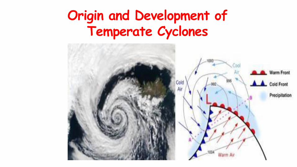
Polar Front Theory According to this theory, the warm-humid air masses from the tropics meet
the dry-cold air masses from the poles and thus a polar front is formed as asurface of discontinuity.
Such conditions occur over sub-tropical high, sub-polar low pressurebelts and along theTropopause.
The cold air pushes the warm air upwards from underneath.
The surrounding air rushed in to occupy this void and coupled with the earth’s rotation, a cyclone is formed which advances with the westerlies (Jet Streams).
By Sudarshan Gurjar

In the northern hemisphere, warm air blows from the south and cold air fromthe north of the front.
The cyclonic circulation leads to a well-developed extra tropical cyclone, with a warm front and a cold front.
There are pockets of warm air or warm sector wedged between the forwardand the rear cold air or cold sector.
The warm air glides over the cold air and a sequence of clouds appear over the sky ahead of the warm front and cause precipitation.
The cold front approaches the warm air from behind and pushes the warm airup. As a result, cumulus clouds develop along the cold front.
By Sudarshan Gurjar

The cold front moves faster than the warm front ultimately overtakingthe warm front. The warm air is completely lifted up and the front is occluded (occluded front) and the cyclone dissipates.
The processes of wind circulation both at the surface and aloft are closely interlinked.
So temperate cyclone is intense frontogenesis involving mainlyocclusion type front.
Normally, individual frontal cyclones exist for about 3 to 10 days moving in a generally west to east direction.
Precise movement of this weather system is controlled by the orientation ofthe polar jet stream in the upper troposphere.
By Sudarshan Gurjar

Polar Front Theory
By Sudarshan Gurjar

By Sudarshan Gurjar

the northern(This is due
Tropical cyclones Tropical cyclones are violent storms that originate over oceans in tropical
areas and move over to the coastal areas bringing about large scaledestruction due to violent winds very heavy rainfall and storm surge.
They are irregular wind movements involving closed circulation of air around alow pressure center. This closed air circulation (whirling motion) is a result ofrapid upward movement of hot air which is subjected to Coriolisforce.
The low pressure at the center is responsible for the wind speeds.
The cyclonic wind movements are anti-clockwise in hemisphere and clockwise in the southern hemisphere to Coriolis force ). The cyclones are often characterized by existence of an anticyclone between two cyclones.

Conditions Favourable for Tropical Cyclone Formation Large sea surface with temperature higher than 27° C,
Presence of the Coriolis force enough to create a cyclonic vortex,
Small variations in the vertical wind speed,
A pre-existing weak low-pressure area or low-level-cycloniccirculation,
Upper divergence above the sea level system,
By Sudarshan Gurjar
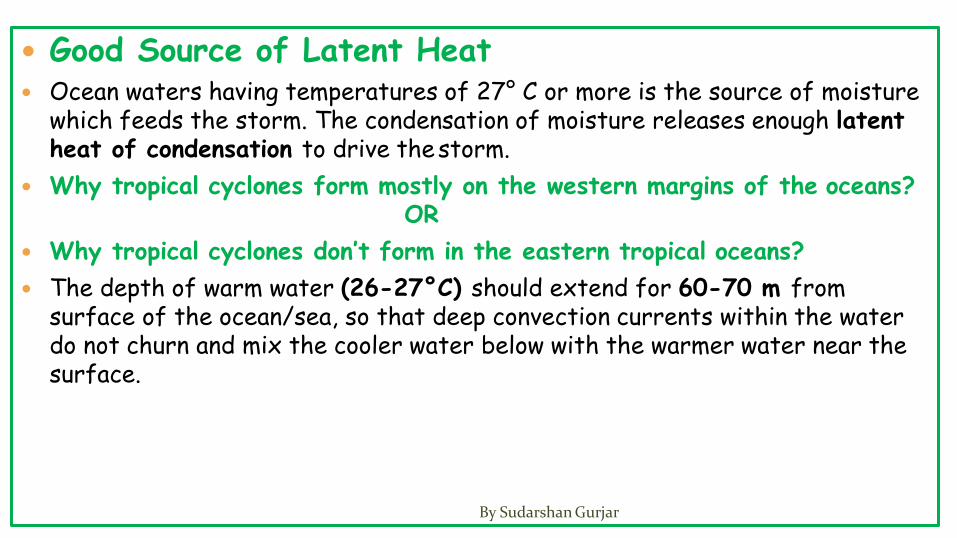
Good Source of Latent Heat Ocean waters having temperatures of 27° C or more is the source of moisture
which feeds the storm. The condensation of moisture releases enough latent heat of condensation to drive thestorm.
Why tropical cyclones form mostly on the western margins of the oceans?OR
Why tropical cyclones don’t form in the eastern tropical oceans?
The depth of warm water (26-27°C) should extend for 60-70 m from surface of the ocean/sea, so that deep convection currents within the water do not churn and mix the cooler water below with the warmer water near the surface.
By Sudarshan Gurjar

By Sudarshan Gurjar
The above condition occurs only in western tropical oceans because of warm ocean currents (easterly trade winds pushes ocean waters towards west) that flow from east towards west forming a thick layer of water with temperatures greater than 27°C. This supplies enough moisture to the storm.
The cold currents lower the surface temperatures of the eastern parts ofthe tropical oceans making them unfit for the breeding of cyclonic storms.

Why cyclones occur mostly in late summers?
This happens during the autumnal equinox (August-September).
At this time, there are two advantages—the air is overheated and the sun isexactly over the equator.
[Due to high specific heat of water, and mixing, the ocean waters in northern hemisphere attain maximum temperatures in August. (Continents attain maximum temperatures in June-July)]
By Sudarshan Gurjar

Coriolis Force (f)
The Coriolis force is zero at the equator (no cyclones at equator becauseof zero Coriolis Force) but it increases with latitude.
Coriolis force at 5° latitude is significant enough to create a storm About 65 per cent of cyclonic activity occurs between 10° & 20°latitude.
By Sudarshan Gurjar
A well – developed divergence in the upper layers of the atmosphere is necessary so that the rising air currents within the cyclone continue to be pumped out and a low pressure maintained at the center.
By Sudarshan Gurjar

Origin and Development of Tropical Cyclone The tropical cyclones have a thermal origin, and they develop over
tropical seas during late summers (August to mid-November).
At these locations, the strong local convectional currents acquire a whirling motion because of the Coriolis force.
After developing, these cyclones advance till they find a weak spot in the trade wind belt.
By Sudarshan Gurjar

Development.
[rising of humid air => adiabatic lapse rate => fall in temperature of air => condensation of moisture in air => latent heat of condensation released=> air gets more hot and lighter => air is further uplifted => more air comes in to fill the gap => new moisture available for condensation => latent heat of condensation and the cycle repeats]

By Sudarshan Gurjar

• Continuous supply of moisture from the sea is the major driving forcebehind every cyclone. On reaching the land the moisture supply is cut off and the storm dissipates.
• If ocean can supply more moisture, the storm will reach a mature stage.

Eye
The ―eye‖is a roughly circular area of comparatively light winds and fair weather found at the center of a severe tropicalcyclone.
There is little or no precipitation and sometimes blue sky or stars can beseen.
The eye is the region of lowest surface pressure and warmest temperatures aloft (in the upper levels) – the eye temperature may be 10°C warmer or more at an altitude of 12 km than the surrounding environment, but only 0-2°C warmer at the surface in the tropical cyclone.
Eyes range in size from 8 km to over 200 km across, but most are approximately 30-60 km in diameter.
By Sudarshan Gurjar

By Sudarshan Gurjar

Regions What they arecalled
Indian Ocean Cyclones
Atlantic Hurricanes
Western Pacific and South China Sea
Typhoons
Western Australia Willy-willy
By Sudarshan Gurjar

By Sudarshan Gurjar

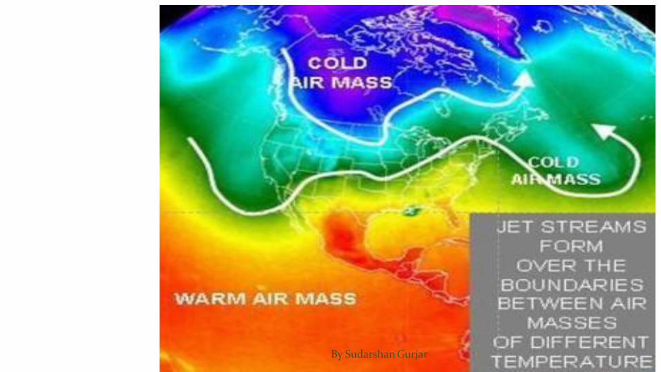
Jet streams are
Circumpolar (situated around or inhabiting around one of the earth’spoles),
narrow, concentrated bands of
meandering,
upper tropospheric,
high velocity,
geostrophic streams,
are a part of upper level westerlies.
By Sudarshan Gurjar
By Sudarshan Gurjar

Circumpolar Jet streams are winds that circle around the earth with poles as
their centers.
By Sudarshan Gurjar

Narrow, concentrated bands The stream of air is very narrow (50-150 km across) and the air in
the stream is directed towards the axis of the stream making it very narrow.
By Sudarshan Gurjar

Meandering When the temperature contrast is maximum, jet stream flows in near
straight path.
But when temperature contrast reduces, the jet stream starts to follow a meandering path.
So meandering depends on temperature contrast (temperaturegradient).
A meander is called peak or ridge if it is towards poles and trough if it is towards equator.
By Sudarshan Gurjar

By Sudarshan Gurjar

Rossby Waves The meandering jet streams are called Rossby Waves.
Rossby waves are natural phenomenon in the atmosphere and oceans due to rotation of earth.
In planetary atmospheres, they are due to the variation in the Coriolis effect (When temperature contrast is low, speed of jet stream is low and Coriolis force is weak leading to meandering) with latitude.
Rossby waves are formed when polar air moves toward the Equator while tropical air is moving poleward.
The existence of these waves explains the low-pressure cells (cyclones) andhigh-pressure cells (anticyclones).
By Sudarshan Gurjar

By Sudarshan Gurjar

By Sudarshan Gurjar

By Sudarshan Gurjar
Upper Tropospheric Jet streams flow just below the Tropopause.
Polar jet streams flow 6 – 9 km above the ground and Sub-tropical jet streams flows 10 –16 km above thegrounds.
Why this difference in height?
Recall that troposphere is thicker at equator – 17 to 18 km, than atpoles – 8 to 9 km.
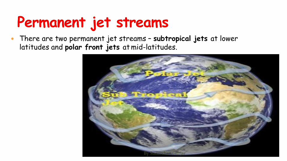
There are two permanent jet streams – subtropical jets at lower latitudes and polar front jets at mid-latitudes.
By Sudarshan Gurjar

Subtrapical Jet Stream (STJ) The sub-tropical jet stream is produced by the earth’s rotation
(Coriolis force) and temperature contrast between tropical and sub tropical regions.
At the equator, the rotation produces greatest velocity in the atmosphere.
As a result the rising air which spreads out northwards and southwards,moves faster than the latitudes over which it is blowing.
It is deflected to the right in the northern hemisphere and to the left in the southern hemisphere, and at about 30° latitude it becomes concentrated as the subtropical jet streams.
During winter, the STJ is nearly continuous in both hemispheres. The STJ exists all year in the southern hemisphere. However, it is intermittent in the northern hemisphere during summer when it migrates north.
By Sudarshan Gurjar

Polar Front Jet (PFJ) The polar front jet is produced by a temperature difference and is
closely related to the polar front
It has a more variable position than the sub-tropical jet. In summer, its position shifts towards the poles and in winter towards the equator.
The jet is strong and continuous in winter.
It greatly influences climates of regions lying close to 60 degree latitude.
It determines the path and speed and intensity of temperate cyclones.
By Sudarshan Gurjar
Jet Streams and Weather in Temperate Regions
How does jet streams affect the weather in temperate regions?
By Sudarshan Gurjar

By Sudarshan Gurjar

Explanation Polar jet has distinct peaks (ridges) and troughs.
Ridges occur where the warm air (at high pressure) pushes against the coldair.
Troughs occur where cold air (at lower pressure) drops into warm air.
This condition occurs due to weak jet stream which is weak due to lesser temperature contrast between sub-tropics and temperate region.
These ridges and troughs give rise to jet streaks which are the main reason behind cyclonic and anticyclonic weather conditions at the surface.
By Sudarshan Gurjar

The winds leaving the jet streak are rapidly diverging, creating a lowerpressure at the upper level (Tropopause) in the atmosphere.
The air below rapidly replaces the upper outflowing winds.
This in turn creates the low pressure at the surface.
This surface low pressure creates conditions where the surrounding surfacewinds rush inwards.
The Coriolis effect creates the cyclonic rotation that is associated with depressions.
By Sudarshan Gurjar

The winds entering the jet streak are rapidly converging, creating a high pressure at the upper level (Tropopause) in the atmosphere.
This convergence at upper troposphere leads to divergence (high pressure) at the surface (anticyclonic condition).
The Coriolis effect creates the anticyclonic rotation that is associated withclear weather.
By Sudarshan Gurjar