from meris to olci ocean colour at...
TRANSCRIPT

Henri Laur et al.
Earth Observation Programmes
European Space Agency
International Ocean Colour Science, Darmstadt, 6 May 2013
From MERIS to OLCI Ocean colour at ESA

Ocean Colour in Europe
Envisat MERIS observations lasted 10 years, until 2012 further expansion of the Ocean Colour community
in Europe
Strong support to MERIS data exploitation possible thanks to adequate funding at ESA (e.g. GlobColour, Climate Change Initiative) and at EC (e.g. GMES marine core services) has fostered strong user acceptance and high demand for long-term
Ocean Colour data for marine & coastal monitoring under environmental policies
Sentinel-3 OLCI will provide continuity of MERIS class observations well into the future
National missions in Europe, e.g. the German hyperspectral Enmap mission, are also relevant for the OC community
The present outlook for ocean colour in Europe is positive
André Morel
European expertise built initially on CZCS, SeaWiFS, MODIS (thanks USA !)
ESA decision as early as 1992 to build ocean colour sensors MERIS launched on-board Envisat in 2002

Overall good performances, with excellent performances of MERIS
No symptoms of degradation in any Envisat module during the days/hours before the anomaly on 8th April 2012
Envisat satellite: 10 years of good performances
Last MERIS image before anomaly
(8 April 2012, 11:05 UTC)
Envisat satellite celebrated its 10th year in orbit in March 2012
Envisat satellite nominal lifetime was 5 years (orbit change in 2010)
Fist MERIS image
(22 March 2002)

Envisat satellite failure on 8th April 2012
Fraunhofer TIRA image (10 April 2012)
Pleiades images
(15 April 2012) Credits CNES
Credits CNES
• Based on the anomaly events on 8th April and on the external observations since then, several failure scenarios were devised.
• Two failure scenarios were retained as most coherent with the observations:
Failure Scenario 1: Non-observable double failure in the Power Subsystem (e.g. a silent first failure could have happened in the past, then second failure on 8th April)
Failure Scenario 2: Failure in Central Communication Unit followed by a failure while the satellite was in transition towards Safe Mode
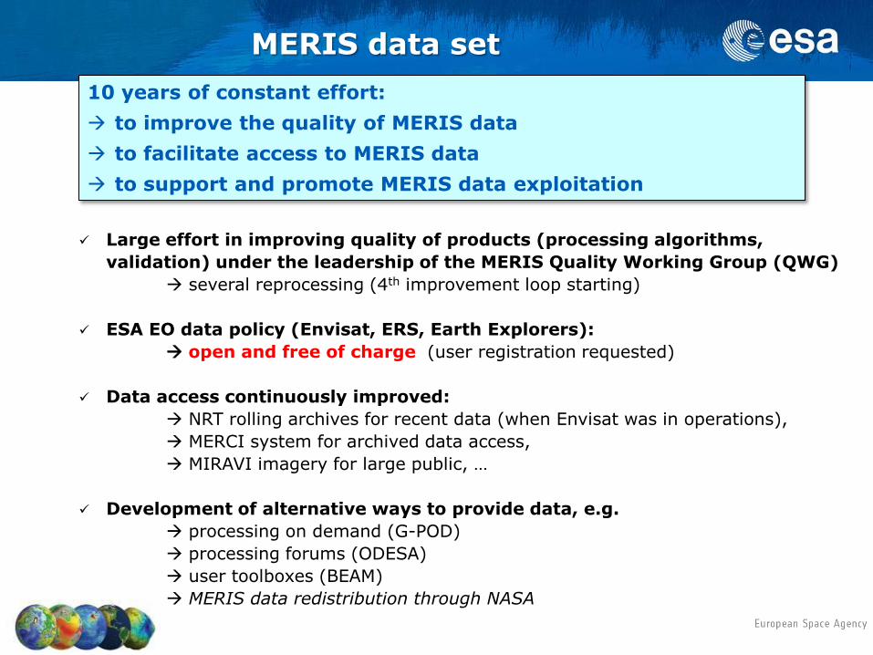
10 years of constant effort:
to improve the quality of MERIS data
to facilitate access to MERIS data
to support and promote MERIS data exploitation
Large effort in improving quality of products (processing algorithms,
validation) under the leadership of the MERIS Quality Working Group (QWG)
several reprocessing (4th improvement loop starting)
ESA EO data policy (Envisat, ERS, Earth Explorers):
open and free of charge (user registration requested)
Data access continuously improved:
NRT rolling archives for recent data (when Envisat was in operations),
MERCI system for archived data access,
MIRAVI imagery for large public, …
Development of alternative ways to provide data, e.g.
processing on demand (G-POD)
processing forums (ODESA)
user toolboxes (BEAM)
MERIS data redistribution through NASA
MERIS data set
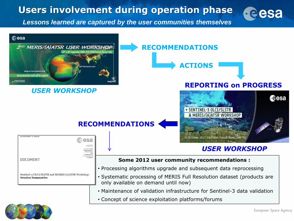
RECOMMENDATIONS
ACTIONS
USER WORKSHOP REPORTING on PROGRESS
Lessons learned are captured by the user communities themselves
Users involvement during operation phase
Some 2012 user community recommendations :
• Processing algorithms upgrade and subsequent data reprocessing
• Systematic processing of MERIS Full Resolution dataset (products are only available on demand until now)
• Maintenance of validation infrastructure for Sentinel-3 data validation
• Concept of science exploitation platforms/forums
RECOMMENDATIONS
USER WORKSHOP

In: Siegel D.A., D. Antoine, M.J. Behrenfeld, O. H. Fanton d'Andon, E. Fields, B.A. Franz, P. Goryl, S. Maritorena, C.R. McClain, M. Wang and J.A. Yoder (2012),
State of Climate 2011 - Global Ocean Phytoplankton, Bulletin of the American Meteorological Society, 93, S107-S110.
Summed monthly anomalies for 2011 Monthly anomalies Northern hemisphere,
where mean SST<15°C
Warm, stratified, ocean where mean SST>15°C
Southern hemisphere, where mean SST<15°C
MERIS is part of the international fleet of ocean colour missions
MODIS
MERIS

Support to MERIS data exploitation
Daily
Weekly
Monthly
Annual
Improved spatial coverage, even at
weekly scale
ESA Climate Change Initiative programme

California Coast
Southern California Texas Coast Mississippi Delta Florida
Chesapeake Bay
Lake Erie
Full Resolution Ocean Color Data and Experimental Products by NOAA CoastWatch

Weekly Lake Erie Bulletin, 500 subscribers, 4th year, 1st year without MERIS !
9 October 2011, the worst bloom in decades, over 5000 sq km

08 09 10 11 12 13 14 15 16 17
1995
2002
Data management to be ensured beyond satellite operations: • Data preservation • Data access • Data reprocessing
1991
ERS-1
Missions operations funded by ESA EOEP-4
2012
SWARM
Data management
ADM-Aeolus
GOCE
SMOS
CryoSat
EarthCARE
Data management
Sentinels (GMES)
Data management
Data management (with LTDP)
ERS-2
Envisat
ESA Earth Observation programmes - overview -
Planned extension
Planned extension
Missions operations funded by European Commission
Proba-1, Landsat-8 (Third Party missions in Earthnet programme)
Proba-Vegetation (Earthwatch programme)
Meteorological missions (Meteosat, MetOp) with
European Ocean Colour
Earth Explorers
EARTH OBSERVING
SYSTEMS
(space, airborne, in-situ)
PUBLIC
POLICIES
(Environment &
Security)
Information
Needs (policy driven)
Space Agencies
In-situ Observing systems
Scientific Community
EO Value Adding Industry
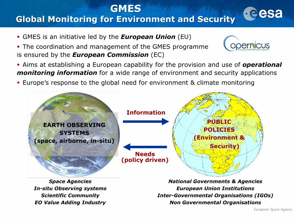
GMES is an initiative led by the European Union (EU)
The coordination and management of the GMES programme
is ensured by the European Commission (EC)
Aims at establishing a European capability for the provision and use of operational
monitoring information for a wide range of environment and security applications
Europe’s response to the global need for environment & climate monitoring
GMES Global Monitoring for Environment and Security
National Governments & Agencies
European Union Institutions
Inter-Governmental Organisations (IGOs)
Non Governmental Organisations

GMES Components
Services Component – coordinated by the European Commission
Produces information services in response to European policy priorities in environment & security
Relies on data from in-situ and space component
In-situ Component – coordinated by the European Environment Agency
Observations mostly within national responsibility, with coordination at European level
Space Component – coordinated by ESA
Ensures data continuity
ESA is procurement agency for the Sentinels: EO missions developed specifically for GMES
ESA coordinates access to “Contributing Missions”: EO missions built for purposes other than GMES but offering part of their capacity to GMES (MSs, EUMETSAT, commercial, international)
http://copernicus.eu
http://gmesdata.esa.int
www.esa.int/GMES
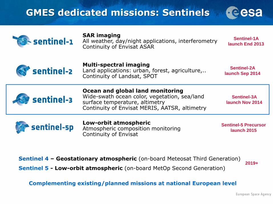
GMES dedicated missions: Sentinels
Sentinel-1A
launch End 2013
SAR imaging All weather, day/night applications, interferometry Continuity of Envisat ASAR
Sentinel-2A
launch Sep 2014
Multi-spectral imaging Land applications: urban, forest, agriculture,.. Continuity of Landsat, SPOT
Ocean and global land monitoring Wide-swath ocean color, vegetation, sea/land surface temperature, altimetry Continuity of Envisat MERIS, AATSR, altimetry
2019+ Sentinel 4 – Geostationary atmospheric (on-board Meteosat Third Generation)
Sentinel 5 - Low-orbit atmospheric (on-board MetOp Second Generation)
Low-orbit atmospheric Atmospheric composition monitoring Continuity of Envisat
Complementing existing/planned missions at national European level
Sentinel-3A
launch Nov 2014
Sentinel-5 Precursor
launch 2015

Sentinel–3: ocean & global land mission
Sentinel-3 is part of the GMES operational mission
High-inclination (98.65 deg.), Sun-synchronous Low Earth Orbit
27 days repeat cycle, equatorial crossing time 10:00 am
Sentinel-3 implements 3 core missions to provide continuity to
existing missions:
• Sea and land colour (at least MERIS quality)
• Sea and land surface temperature (at least AATSR quality)
• Sea surface topography (at least Envisat Altimeter quality)
Full performance achieved with 2 satellites in orbit
A series of satellites (A/B/C/D), each designed for a lifetime of 7
years, shall provide an operational service over 15 to 20 years
2 satellites (A and B units) are in development at the moment
Launch of the first Sentinel-3 (A unit) planned for Nov. 2014
EUMETSAT will be the operator of the marine part of Sentinel-3
ESA will be the operator of the land part of Sentinel-3

Comparison MERIS-OLCI
OLCI key improvements:
21 bands (MERIS + 6): 400-1020 nm
slightly broader swath: 1270 km
Sun glint free configuration by design:
across-track tilt 12.20° in west direction
Full Resolution (260m x 300m) acquired systematically
over both land & ocean
Reduced Resolution (1200m) over ocean, binned on ground (L1B)
improved instrument characterisation, e.g. straylight
short revisit times for optical payload:
at equator: 1 satellite < 4 days, 2 satellites <2 days
100% overlap with SLSTR
55°
46,5°
934 km 335 km
22,1°
λ center Width
412.5 10
442.5 10
490 10
510 10
560 10
620 10
665 10
681.25 7.5
708.75 10
753.75 7.5
761.25 2.5
778.75 15
865 20
885 10
900 10
New OLCI bands λ center Width
Aerosol correction 400 15
Fluorescence retrieval 673.75 7.5
Atmospheric correction 764.375 3.75
Cloud top pressure 767.5 2.5
Atmos./aerosol correction 940 20
Atmos./aerosol correction 1020 40
MERIS bands
OLCI = Ocean & Land Color Instrument
strongly inherited from the flight-proven
MERIS of Envisat (spectral bands and
radiometric performances)
Recent main achievements
• Satellite AIT started following delivery to the Prime of the Sentinel-3A Platform Module
Current main criticalities
• SLSTR and OLCI Instrument delivery dates still critical, despite introduction of double shift work
• Unclear interpretation of US Department of State clarification note issued in Feb 2013 indicating applicability of ITAR rules retroactively on items originally classified as EAR, blocking delivery of a number of Sentinel-3 units
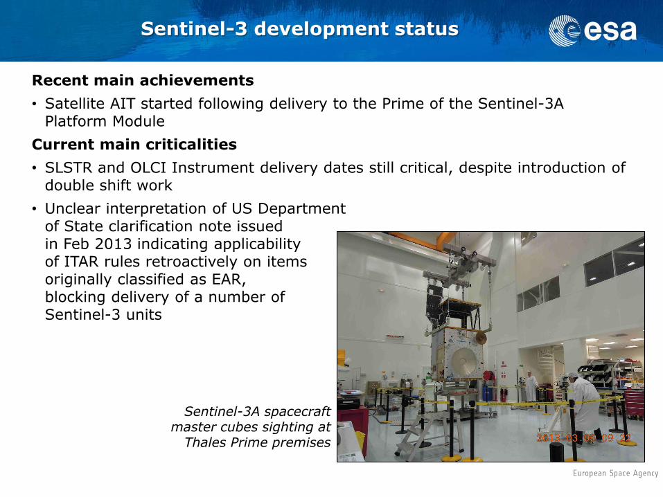
Sentinel-3A spacecraft master cubes sighting at
Thales Prime premises
Sentinel-3 development status
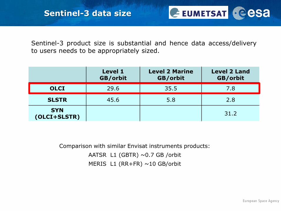
Sentinel-3 product size is substantial and hence data access/delivery to users needs to be appropriately sized.
Comparison with similar Envisat instruments products:
AATSR L1 (GBTR) ~0.7 GB /orbit
MERIS L1 (RR+FR) ~10 GB/orbit
Sentinel-3 data size
Level 1 GB/orbit
Level 2 Marine GB/orbit
Level 2 Land GB/orbit
OLCI 29.6 35.5 7.8
SLSTR 45.6 5.8 2.8
SYN (OLCI+SLSTR)
31.2

• Joint Principles for a GMES Sentinel data policy: (2009 approved ESA document)
Anybody can access acquired Sentinel data; in particular no difference is made between public, commercial and scientific use and in between European or Non-European users
The licenses for the Sentinel data itself are free of charge (…)
• EC presently drafting a GMES data and information policy, based on the Joint Principles (see above) in the shape of a Delegated Regulation, to be approved in 2013.
Sentinel data policy

… the GMES Space Component (GSC) Operations Concept, which will rely on a GSC Ground Segment consisting of a:
1. GSC Core Ground Segment (GSC-funded), providing:
– the primary data access to Sentinel Missions, and
– the coordinating access functions to the GMES Contributing Missions data,
2. GSC Collaborative Ground Segment (non GSC-funded) providing:
– a supplementary access to Sentinel Missions data i.e. either through specific data acquisition services (e.g. Quasi-Real-Time), or specific data products ..
– the frame for international cooperation
Sentinel-3 operations are part of …
Access to data through collaborative agreements provides added value via the development of operational ground segment services complementing the GSC ground segment core services.
The collaboration provides a frame for specialised solutions to further enhance the Sentinels missions exploitation in the area of:
1. Sentinels data acquisition and (quasi-) Real Time production
2. Complementary collaborative data products and algorithms definition
3. GSC data product dissemination and access (e.g. mirror sites)
4. Development of innovative tools and applications
It is envisaged to use this scheme as a mechanism to formalise the participation to the Sentinel-3 cal & val teams:
5. External validation support
The collaboration will rely on the definition of formal agreements as well as the technical definition of dedicated operational interfaces.
Discussions on collaborative ground segment are currently taking place with ESA/EC Member States.
GMES space component Collaborative Ground Segment

Conclusions
Europe has a strong satellite ocean colour programme
Effort will be maintained for MERIS data reprocessing
Sentinel-3 launch is foreseen towards end 2014
Present ESA data policy (MERIS) and future EC/ESA Sentinel data
policy as well as the GMES Space Component Operations Concept
open collaboration with International partners
Europe has a particular need in accessing common reference
in-situ infrastructures which are essential for sensor calibration
and product validation