from: j subject: stafford regional airport compatible...
TRANSCRIPT
1300 Courthouse Road, P. O. Box 339, Stafford, VA 22555‐0339 Phone: (540) 658.8600 Fax: (540) 658.7643 www.staffordcountyva.gov
Board of Supervisors
Gary F. Snellings, Chairman Laura A. Sellers, Vice Chairman Meg Bohmke Jack R. Cavalier Paul V. Milde, III Cord A. Sterling Robert “Bob” Thomas, Jr.
Anthony J. Romanello, ICMA‐CM
County Administrator
January 28, 2015
MEMORANDUM TO: Stafford County Planning Commission
FROM: J
SUBJECT: Stafford Regional Airport Compatible Land Use Plan
At the last meeting on January 14th
, the attached draft Stafford Regional Airport Compatible Land Use
Plan was provided to the Commission. At this meeting, staff will give a presentation on the background
and details of the Plan.
JAH:MJZ:mz
Attachment (1)
7

CHAPTER 3.6 STAFFORD REGIONAL AIRPORT PLANNING AREA
A. Introduction
The Stafford Regional Airport is located in an area of the County that is anticipated to experience growth
in the future. The area surrounding the Stafford Regional Airport was primarily agricultural and rural
residential with very low density housing when it was initially sited in 1987. The growth pattern in the
area has changed since that time with the construction of the Centerport Parkway in 2006 and
amendments to the Future Land Use Plan in 2010 which allows for the potential of higher density
development. The Airport Master Plan anticipates the extension of the existing runway and an increase
in operations.
The Comprehensive Plan recognizes the need to plan for growth that is compatible with the airport in
the following ways:
Chapter 2 (page 2-26) includes a recommendation for the development of land use compatibility
standards:
Objective 4.9. Minimize the noise impacts and potential safety hazards generated by general
aviation at public and private airfields in the County.
Policy 4.9.1. The County should develop land use compatibility standards for new development to
conform to within the aircraft approach patterns of airports and landing strips.
Chapter 6 (page 6-10) includes the recognition of the current zoning overlay district:
Overlay Districts In addition to the base zoning districts, the Stafford County Zoning Ordinance contains eight overlay districts. The purposes of the districts vary from protecting historical and environmental resources, reducing conflicts between established facilities, and mitigating potential hazards.
Overlay districts add a variety of standards to the underlying districts. These standards could include use restrictions, preservation requirements, or stricter density regulations. The following is a list of the overlay districts used in Stafford County:
AD Airport Impact - Provides an overlay zone in areas subject to intense and/or frequent
emissions of noise and vibration from airports and prevents obstructions of airport zones which
may result in an air navigation hazard.
An Airport Planning Area is established in order to further define and address the specific planning
considerations related to land use compatibility including potential impacts related to exposure to
aircraft noise, land use safety with respect both to people on the ground and the occupants of aircraft;
the protection of airport airspace; and general concerns related to aircraft overflights. The Airport
Planning Area consists of Airport Impact Zones that are defined in section C of this chapter.
DRAFT - December 18, 2014 REVISION 6
1

B. Background of the Stafford Regional Airport
The Stafford Regional Airport is located in the center of Stafford County and is situated approximately 40
miles southwest of Washington D.C., 50 miles north of Richmond, Virginia and approximately 5 miles
north of Fredericksburg, Virginia.
The need for a new public general aviation airport in Stafford County was determined in 1972 as part of
the National Airport System Plan. In 1977 Stafford County conducted a feasibility study which detailed
a need for a transport category airport in the region. A series of environmental studies were
conducted between 1977 and 1992 and resulted in the final selection of an airport site in the central
Stafford County area, adjacent to Interstate 95. Construction of the Airport began in 1997 and the
airport opened in December 2001. The Airport was completed for just over $41M dollars, $5M
under its allocated budget. This included an investment of $820k from the Stafford Regional Airport
Authority, almost $39M from the Federal Aviation Administration (FAA) and approximately $1.25M in
Commonwealth of Virginia funding. The Airport Improvement Program Handbook states, with
regard to any airport sponsor, “It (the airport sponsor) will take the appropriate action, to the
extent reasonable, including the adoption of zoning laws, to restrict the use of land adjacent to or in
the immediate vicinity of the airport to activities and purposes compatible with normal airport
operations, including landing and takeoff of aircraft.”
Significant airport development of more than $14M has occurred since the Airport was originally
constructed with the bulk coming from the FAA. This construction includes the addition of
T- Hangars, two corporate hangars, apron areas, auto parking, fuel farm, security fencing, an
instrument landing system (ILS), an approach lighting system and a new terminal building that opened
in January 2014. The FAA and DOAV provide nearly all of the funding for future airport
improvements and it is imperative that Stafford County establish and maintain high quality
development compatibility standards to insure that future expenditures are used to improve the
airport instead of noise abatement measures due to poor development planning.
The Airport is governed by a seven member Airport Authority (Stafford Regional Airport Authority or
SRAA). These appointed members serve four year terms and represent Stafford County (four
members), Prince William County (two members), and the City of Fredericksburg, Virginia (one
member). A fulltime airport manager is located at the Stafford Regional Airport and handles the daily
operation of the facility.
The Stafford Regional Airport service area includes Stafford County and portions of eight
surrounding counties plus the City of Alexandria and Washington D.C. as determined by the Virginia
Department of Aviation (DOAV) 2003 Virginia Air Transportation System Plan (VATSP) and airport
records.
The Stafford Regional Airport is served by a single 5,000’ x 100’ grooved runway (15-33) as shown
on the Airport Layout Plan in Exhibit 1. This runway is oriented 150 and 330 degrees and has a full-
length parallel taxiway. Runway 15-33 utilizes High Intensity Runway Lights (HIRL) which can be
operated by pilots using the Airport’s Unicom frequency (122.725). Medium Intensity Taxiway
DRAFT - December 18, 2014 REVISION 6
2

Lighting (MITL) is also available to pilots to assist in night operations, giving the facility 24-hour
operational capability.
Exhibit 1: Airport Layout Plan
The Stafford Regional Airport currently has three instrument approach procedures consisting of an ILS
approach, VOR approach, and a GPS approach. The ILS is an Instrument Landing System which
uses radio waves broadcast from the Airport to align aircraft with the approach path to the runway.
Runway 33 at the Airport has a Category 1 ILS System which enables aircraft with IFR (Instrument
Flight Rules) equipment to land at RMN in inclement weather. Non-Precision instrument approaches
(GPS or RNAV) for runway 15 have been developed and reviewed by the FAA but not implemented at
this time.
Aircraft operating at the Stafford Regional Airport use existing traffic patterns based on the type and
speed of the aircraft. The Airport currently operates with a standard left-hand traffic pattern for
runway 33 and a nonstandard right-hand pattern for runway 15 as shown in Exhibit 2. This
nonstandard pattern was temporarily implemented due to the proximity of a landfill which can serve as
a bird attractant. Airport layout plans call for reinstituting the standard left-hand traffic pattern
on Runway 15 once the closest landfill cell to the Airport is closed as shown in Exhibit 3.
An operation is defined as either a takeoff or a landing at the airport. Existing airport activity
exceeds 23,000 operations per year and a modest growth rate of approximately 1,000 operations per
year for the next several years is projected. This figure is supported by the FAA and DOAV as indicated
in the approved Airport Master Plan update that was completed in April 2013.
According to the 2011 Virginia Statewide Economic Impact Study, the Stafford Regional Airport provided
105 direct and indirect jobs and contributed $18.2M in economic activity to the region in 2010. This
impact demonstrates the value that the Stafford Regional Airport adds to the region as an economic
engine.
(Source: Stafford Regional Airport Compatible Land Use Study, May 2014, Talbert and Bright, Inc.)
DRAFT - December 18, 2014 REVISION 6
3

Exhibit 2: Non-standard Traffic Pattern
Exhibit 3: Standard Traffic Pattern
DRAFT - December 18, 2014 REVISION 6
4

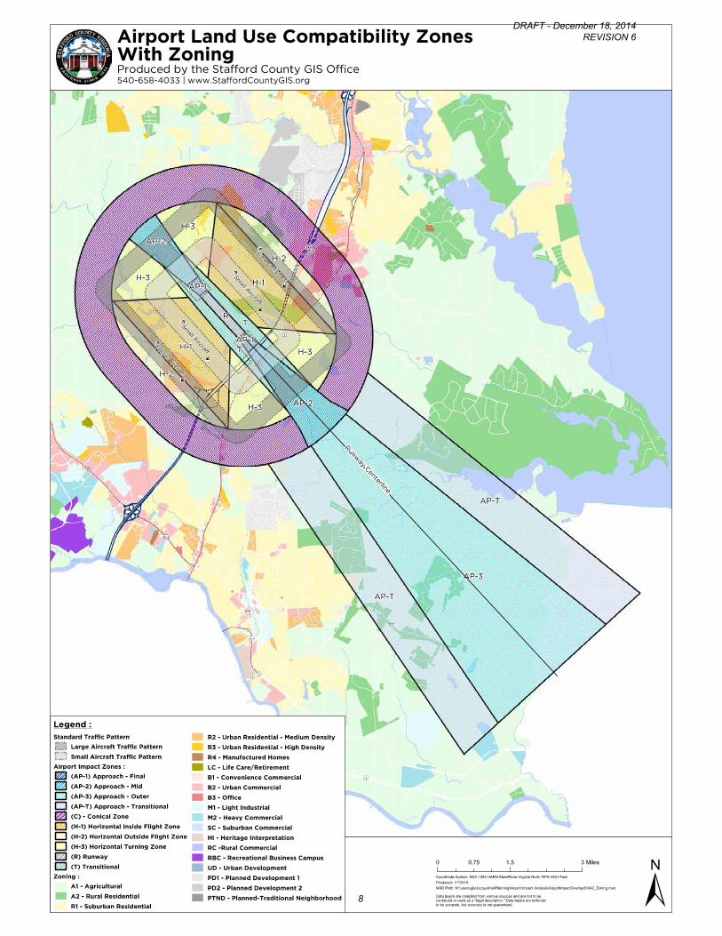
C. Airport Impact Zones
The Airport Impact Zones that make up the Airport Planning Area define and address the specific
planning considerations related to land use compatibility in the area identified in the Airport Impact
Overlay District and the Stafford Regional Airport Master Plan. The specific planning considerations
include potential impacts related to exposure to aircraft noise, land use safety with respect both to
people on the ground and the occupants of aircraft; the management of airport airspace; and general
concerns related to aircraft overflights. This Plan designates Airport Impact Zones that closely
correspond with the existing Airport Impact Zoning Overlay District. The zones are utilized in establishing
the corresponding land use compatibility standards.
Approach zones reflect the approach and departure areas for the runway and are divided into several
sub areas.
Approach –Final, Runway Protection Zone (AP-1). The closest area at the end of each runway,
beginning 200-feet from the end of each runway, extending approximately two thousand five
hundred (2,500) feet to the east and one thousand seven hundred (1,700) feet to the west.
Approach – Mid (AP-2). The area that fans out from the Runway Protection Zone, extending
fourteen thousand (14,000) feet to the east and ten thousand (10,000) feet to the west.
Approach – Outer (AP-3). The area that fans out to the east of the runway that extends from
fourteen thousand (14,000) feet to fifty thousand (50,000) feet from the runway.
Approach – Transitional (AP-T). A 5,000 foot wide area extending along each side of the Outer
Approach, beyond the Conical zone.
Transitional (T). The area that fans away perpendicular to any airport runway centerline and approach
surfaces
Horizontal zones include the area that is established by swinging arcs of ten thousand (10,000) feet radii
from the center of the end of the primary surface of an airport runway and connecting adjacent arcs by
drawing lines tangent to those areas. The horizontal zone excludes the approach and transitional zones.
The area is divided into two sub-areas for the purpose of land use compatibility.
Horizontal – Inside Flight Pattern (H-1). The inner portion of the Horizontal zone that encompasses
the majority of the existing and future aircraft traffic patterns.
Horizontal – Outside Flight Pattern (H-2). The outer portion of the Horizontal Zone that
encompasses the outer edge of the Jet/Turboprop (large) aircraft traffic patterns.
Horizontal – Turning Areas (H-3). The area of the Horizontal zone that encompasses the portion of
the traffic pattern area where turning movements occur, where aircraft generate louder noise and
there is increased accident probability.
Conical (C). The area that surrounds and commences at the periphery of the horizontal zone (10,000
feet from the Runway Clear Zone) and extends outward from there for a distance of four thousand
(4,000) feet.
DRAFT - December 18, 2014 REVISION 6
5

DRAFT - December 18, 2014 REVISION 6
6

D. Analysis of the Planning Area
The following analysis shows the area of existing zoning classifications within each zone and the future
land use designations, which identify the types of potential development that may occur. When
comparing current zoning to future land use, the greatest potential for incompatible development to
occur is within the Horizontal Zone. The majority of the area is zoned A-1, Agricultural, with the
potential of being rezoned as the land is planned for Business and Industry, Suburban and Urban
Development Area (UDA) future land use designations. The land use designations within the Horizontal
Zone are described below:
Business and Industry – 1,533 acres - Uses include retail, wholesale, corporate and professional offices,
research and development, entertainment, manufacturing, distribution and transportation; possible
heavy industrial uses; new and used vehicle sales, including automobiles and boats.
Suburban – 725 acres - Uses include single family detached dwelling units, typically on ¼ to ½ acre lots,
maximum density of 3 du/ac; neighborhood and community oriented activity centers, places of worship,
parks and play areas, and retail and business activities with a maximum floor area ratio (FAR) of 0.4.;
industrial uses include warehousing, wholesaling, manufacturing, processing operations, mixed-use
commercial/industrial development, and flex office space.
Urban Development Areas – mix of uses including approximately 8,829 dwelling units and 13,900,800
square feet of commercial retail and office space in an area totaling approximately 3,196 acres, 2,300
acres of which are within the Horizontal Zone.
DRAFT - December 18, 2014 REVISION 6
7
DRAFT - December 18, 2014 REVISION 6
8

DRAFT - December 18, 2014 REVISION 6
9

Existing Future Land Uses and Zoning District Classifications by Airport Impact Zone
1. Final Approach Compatibility Zone (AP-1)
0
20
40
60
80
100
120
140
Business and Industry Resource Protection Area
Acr
eag
e (
Ac)
Future Land Use Type
Future Land Use Acreage within AP-1
0
20
40
60
80
100
120
A1 M1 ROW
Acr
eag
e (
Ac)
Zoning Type
Zoning Acreage within AP-1
Future Land Use Acres
Business and Industry 130.42
Resource Protection Area 0.21
Zoning Acres
A1 2.12
M1 103.05
ROW 25.46
DRAFT - December 18, 2014 REVISION 6
10
2. Middle Approach Compatibility Zone (AP-2)
0100200300400500600700800900
1000
Tota
l Acr
eag
e (
Ac)
Future Land Use Type
Future Land Use Acreage within AP-2
0
200
400
600
800
1000
1200
1400
A1 B1 B2 M1 ROW
Tota
l Acr
eag
e (
Ac)
Zoning Type
Zoning Acreage within AP-2
Future Land Use Acres
Agricultural/Rural 885.18
Business and Industry 278.98
Park 36.74
Resource Protection Area 251.23
Suburban 57.30
Urban Development Areas 0.33
Zoning Acres
A1 1303.13
B1 1.74
B2 12.48
M1 169.78
ROW 22.62
DRAFT - December 18, 2014 REVISION 6
11
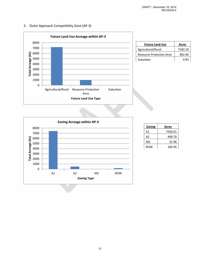
3. Outer Approach Compatibility Zone (AP-3)
0
1000
2000
3000
4000
5000
6000
7000
8000
Agricultural/Rural Resource ProtectionArea
Suburban
Tota
l Acr
eag
e (
Ac)
Future Land Use Type
Future Land Use Acreage within AP-3
0
1000
2000
3000
4000
5000
6000
7000
8000
A1 A2 M2 ROW
Tota
l Acr
eag
e (
Ac)
Zoning Type
Zoning Acreage within AP-3
Future Land Use Acres
Agricultural/Rural 7183.19
Resource Protection Area 962.46
Suburban 0.95
Zoning Acres
A1 7430.01
A2 490.70
M2 31.96
ROW 184.95
DRAFT - December 18, 2014 REVISION 6
12

4. Transitional Approach Compatibility Zone (AP-T)
01000200030004000500060007000
Tota
l Acr
eag
e (
Ac)
Future Land Use Type
Future Land Use Acreage within AP-T
0
1000
2000
3000
4000
5000
6000
A1 A2 B1 M1 M2 PD1 R1 RC ROW
Tota
l Acr
eag
e (
Ac)
Zoning Type
Zoning Acreage within AP-T
Future Land Use Acres
Agricultural/Rural 5733.86
Park 273.53
Resource Protection Area 1232.03
Suburban 513.13
Urban Development Areas 63.26
Zoning Acres
A1 5689.74
A2 1404.22
B1 3.62
M1 109.61
M2 20.69
PD1 24.81
R1 232.76
RC 3.80
ROW 260.43
DRAFT - December 18, 2014 REVISION 6
13
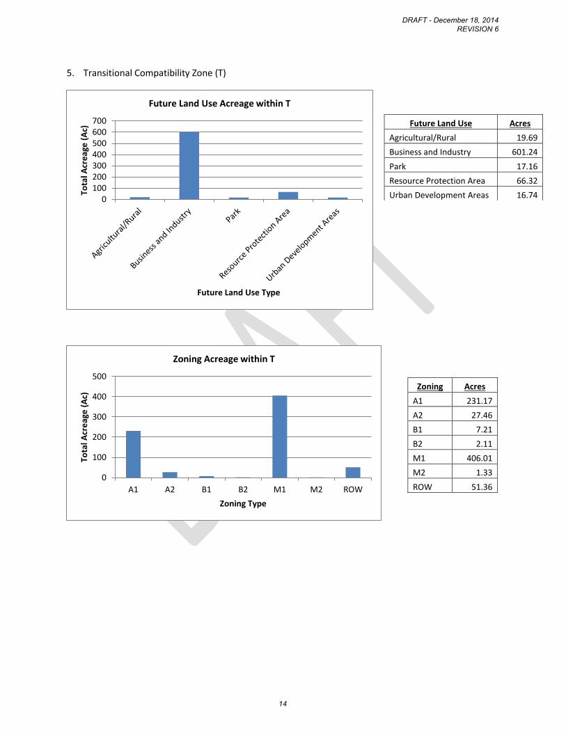
5. Transitional Compatibility Zone (T)
0100200300400500600700
Tota
l Acr
eag
e (
Ac)
Future Land Use Type
Future Land Use Acreage within T
0
100
200
300
400
500
A1 A2 B1 B2 M1 M2 ROW
Tota
l Acr
eag
e (
Ac)
Zoning Type
Zoning Acreage within T
Future Land Use Acres
Agricultural/Rural 19.69
Business and Industry 601.24
Park 17.16
Resource Protection Area 66.32
Urban Development Areas 16.74
Zoning Acres
A1 231.17
A2 27.46
B1 7.21
B2 2.11
M1 406.01
M2 1.33
ROW 51.36
DRAFT - December 18, 2014 REVISION 6
14

6. Inner Horizontal Compatibility Zone (H-1)
0
200
400
600
800
1000
1200
Tota
l Acr
eag
e (
Ac)
Future Land Use Type
Future Land Use Acreage within H-1
0
200
400
600
800
1000
1200
1400
1600
A1 A2 B1 B2 B3 M1 M2 R2 R3 ROW
Tota
l Acr
eag
e (
Ac)
Zoning Type
Zoning Acreage within H-1
Future Land Use Acres
Agricultural/Rural 367.09
Business and Industry 862.89
Resource Protection Area 513.69
Suburban 121.38
Urban Development Areas 1024.09
Zoning Acres
A1 1431.06
A2 311.37
B1 0.40
B2 89.20
B3 36.59
M1 711.89
M2 15.96
R2 46.85
R3 12.34
ROW 233.49
DRAFT - December 18, 2014 REVISION 6
15
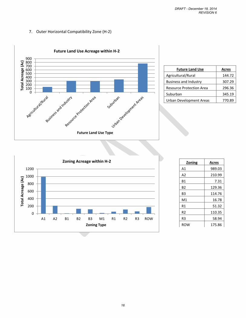
7. Outer Horizontal Compatibility Zone (H-2)
0100200300400500600700800900
Tota
l Acr
eag
e (
Ac)
Future Land Use Type
Future Land Use Acreage within H-2
0
200
400
600
800
1000
1200
A1 A2 B1 B2 B3 M1 R1 R2 R3 ROW
Tota
l Acr
eag
e (
Ac)
Zoning Type
Zoning Acreage within H-2
Future Land Use Acres
Agricultural/Rural 144.72
Business and Industry 307.29
Resource Protection Area 296.36
Suburban 345.19
Urban Development Areas 770.89
Zoning Acres
A1 989.03
A2 210.99
B1 7.31
B2 129.36
B3 114.76
M1 16.78
R1 51.32
R2 110.35
R3 58.94
ROW 175.86
DRAFT - December 18, 2014 REVISION 6
16
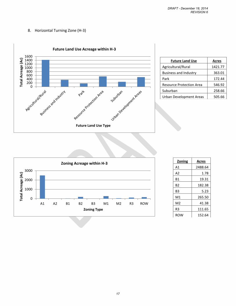
8. Horizontal Turning Zone (H-3)
0200400600800
1000120014001600
Tota
l Acr
eag
e (
Ac)
Future Land Use Type
Future Land Use Acreage within H-3
0
1000
2000
3000
A1 A2 B1 B2 B3 M1 M2 R3 ROW
Tota
l Acr
eag
e (
Ac)
Zoning Type
Zoning Acreage within H-3
Future Land Use Acres
Agricultural/Rural 1421.77
Business and Industry 363.01
Park 172.44
Resource Protection Area 546.92
Suburban 258.66
Urban Development Areas 505.66
Zoning Acres
A1 2488.64
A2 1.78
B1 19.31
B2 182.38
B3 5.23
M1 265.50
M2 41.38
R3 111.65
ROW 152.64
DRAFT - December 18, 2014 REVISION 6
17
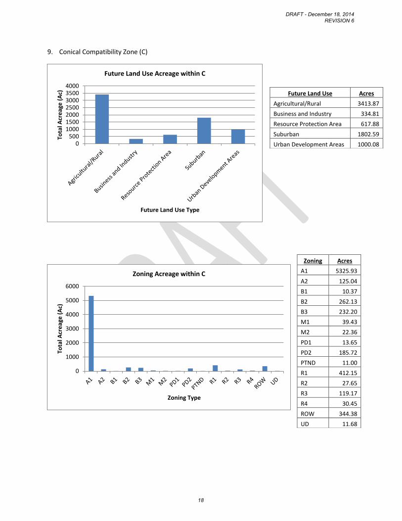
9. Conical Compatibility Zone (C)
0500
1000150020002500300035004000
Tota
l Acr
eag
e (
Ac)
Future Land Use Type
Future Land Use Acreage within C
0
1000
2000
3000
4000
5000
6000
Tota
l Acr
eag
e (
Ac)
Zoning Type
Zoning Acreage within C
Future Land Use Acres
Agricultural/Rural 3413.87
Business and Industry 334.81
Resource Protection Area 617.88
Suburban 1802.59
Urban Development Areas 1000.08
Zoning Acres
A1 5325.93
A2 125.04
B1 10.37
B2 262.13
B3 232.20
M1 39.43
M2 22.36
PD1 13.65
PD2 185.72
PTND 11.00
R1 412.15
R2 27.65
R3 119.17
R4 30.45
ROW 344.38
UD 11.68
DRAFT - December 18, 2014 REVISION 6
18
E. Land Use Compatibility Guidelines
The following guidelines are proposed in order to better address the potential for incompatible land
uses and development within the Airport Planning Area:
GOAL: Stafford County shall promote the appropriate use of land in the Airport Planning Area to
maintain and support the viability of the Stafford Regional Airport and protect and promote the general
health, safety, welfare of the citizens, and overall economy in the airport area.
OBJECTIVE 1: Identify the compatibility of various land uses and establish development standards in
relation to airport operations to minimize potential impacts related to exposure to aircraft noise, land
use, and safety with respect both to people on the ground and the occupants of aircraft and ensure the
protection of airport airspace.
Policy 1.1 General concerns related to aircraft overflights shall be identified and mitigated during the
development review process for all applications for uses within the Airport Planning Area.
Policy 1.2: All development within the Airport Planning Area shall be consistent with the Land Use
Compatibility Matrix (Table 1) that identifies whether uses are Compatible, require Additional Review or
are Incompatible within each Airport Impact Zone.
Policy 1.3: The compatibility guidelines shall be applied in conjunction with the requirements of the
Future Land Use Plan recommendations.
Policy 1.4: The impacts of the following factors shall be considered for any development application
within the Airport Planning Area:
1. Height of all structures and vegetation per the FAR Part 77 requirements;
2. Management of earth disturbances and the creation of open dirt areas during activities such as
farming and construction to minimize dust emissions;
3. Reflective surfaces which cause glare, including storm water retention ponds, solar panels
and/or light-colored or mirrored building materials;
4. Light emissions shining upward into the flight path, flashing lights or lights arranged in a linear
pattern;
5. Uses that generate smoke, steam or fog;
6. Potential to attract wildlife and create habitat, such as open space and agricultural uses;
7. Number of people per unit of area per proposed use;
8. Existence of above ground storage of large quantities of materials that are hazardous, such as
flammable, explosive, corrosive, or toxic materials;
9. Location of proposed uses where mobility of users is limited, such as schools, hospitals and
nursing homes;
10. Location of critical community infrastructure, such as power plants, electrical substations, and
public communications facilities, away from areas where damage or destruction could occur
DRAFT - December 18, 2014 REVISION 6
19
and cause significant adverse effects to public health and welfare beyond the immediate
vicinity of the facility;
11. Proposed percentage of open space, including usable open space, in relation to the
development area. For the purposes of this document, usable open space should be open areas
that are long, level and free of obstacles that could serve as an emergency landing site to
promote public safety. The ideal site would be at least 300 feet by 75 feet and be clear of
obstacles;
12. Compatibility of all proposed uses with the Compatibility Matrix in Table 1.
Policy 1.5: The following standards shall apply to all development within the Airport Planning Area:
1. Final subdivision plats, site specific development plans, or any other document filed as part of
any approval process with Stafford County shall contain the following disclosure statement:
All or a portion of this property lies within the Airport Overlay District. Persons
on the premises may be exposed to noise and other effects as may be inherent in
airport operations;
2. Avigation easements shall be dedicated to Stafford Regional Airport for all new residential,
commercial, industrial, institutional or recreational buildings or structures intended for
habitation or occupancy by humans or animals to allow unobstructed passage for aircraft
related to the height requirements per FAR Part 77;
3. Applicable use restrictions shall apply only to the area of development within the respective
compatibility zone;
4. Height restrictions are effective at all times;
5. Underground utilities are encouraged for all development located within approach zones (AP-1
& AP-2) and traffic pattern areas (H-1, H-2, & H-3);
6. Minimize the occurrence of sunlight glare and wildlife attractants from stormwater
management ponds affecting pilots by limiting the size of ponds to under ½ acre in size and
encouraging dry ponds.
Policy 1.6: Uses identified in Table 1 as requiring “Additional Review” shall follow the specific
development standards identified in Table 2. The factors to consider during “Additional Review” shall
include, but may not be limited to: size, scope and scale of a development, such as the area, building
height, and number and square footage of structures; proposed use(s); location of the development in
relation to the airport; location of uses on an individual site; proposed mitigation measures; population
concentrations; and project externalities, defined as impacts related to the development of the project
that may extend beyond the limits of the project both horizontally and vertically.
Policy 1.7: The following additional standards shall apply to Non-Residential Uses that require Additional
Review in Table 1:
1. Activities and structures associated with the use shall not exceed the maximum building
envelope ratio and/or site population limitation;
DRAFT - December 18, 2014 REVISION 6
20

2. Incorporate shielding, such as the use of full cut-off lighting, lower intensity or other techniques
to avoid the occurrence of light emissions shining upward into the flight path; flashing lights; or
lights arranged in a linear pattern;
3. Waste disposal facilities shall not be located within 10,000 feet of the runway protection zone;
4. Provision of new private airfields or runways shall not be permitted within the planning area;
5. Additional open space requirements, height limitations and square footage limitations will apply
to uses with concentrations of people.
Policy 1.8: The following additional standards shall apply to Residential Uses that require Additional
Review in Table 1:
1. Development proposals shall not exceed the maximum density limitations established and
further described in the Table 2 Additional Review Standards;
2. Development within the airport operations area shall be constructed to include sound insulation
methods to achieve maximum internal noise levels of 45 dBc Ldn (average daily noise level);
3. Disclosure notification for all future purchasers of the property will be required for all residential
development within an airport compatibility zone;
4. Provide contiguous open space in conjunction with clustering of residential development areas.
Policy 1.9: Specific projects which are Not Compatible, as identified in Table 1 may be appropriate if it
can be demonstrated that the specific project would not negatively impact airport operations or safety
of the general public upon additional review, consistent with the guidelines.
Policy 1.10: If a proposed use is not listed in Table 1, the use determined to be most similar would apply
and would be evaluated against the related Additional Review criteria and any other standards deemed
appropriate.
Policy 1.11: The County shall support efforts of the Airport Authority or other entity to acquire land
and/or purchase development rights by coordinating receiving areas outside of the planning area in
order to encourage compatible land uses within the planning area.
IMPLEMENTATION POLICIES
Policy 1.12: For projects in the Airport Planning Area, the County shall coordinate review of all proposed
development applications, including, but not limited to, zoning reclassifications, conditional use permits,
site plans, and preliminary plans, with the Airport Authority and the Virginia Department of Aviation for
compatibility with airport operations and plans for the purpose of receiving advisory comments and
encouraging participation at County development review meetings.
Policy 1.13: The Zoning Ordinance shall be revised to implement the Compatibility Guidelines
recommendations, including use restrictions, and development and building standards, and make
commensurate adjustments to the Airport Overlay District.
DRAFT - December 18, 2014 REVISION 6
21

Policy 1.14: Comprehensive Plan amendments and Ordinance amendments applicable to land within the
Airport Planning Area shall be reviewed for compatibility with the Regional Airport Master Plan,
Compatibility Matrix (Table 1) and related criteria and standards.
DRAFT - December 18, 2014 REVISION 6
22
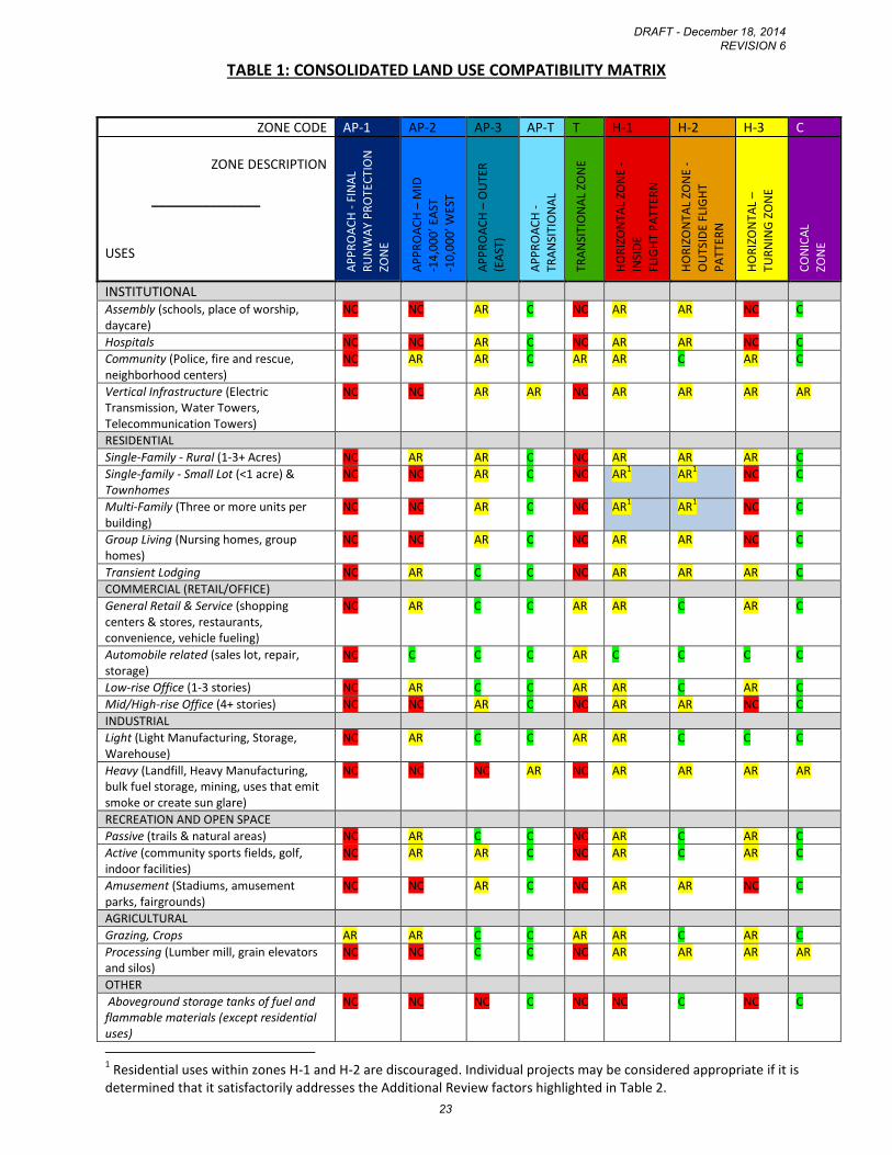
TABLE 1: CONSOLIDATED LAND USE COMPATIBILITY MATRIX
1 Residential uses within zones H-1 and H-2 are discouraged. Individual projects may be considered appropriate if it is
determined that it satisfactorily addresses the Additional Review factors highlighted in Table 2.
ZONE CODE AP-1 AP-2 AP-3 AP-T T H-1 H-2 H-3 C
ZONE DESCRIPTION
_______________
USES
AP
PR
OA
CH
- F
INA
L R
UN
WA
Y P
RO
TEC
TIO
N
ZON
E
AP
PR
OA
CH
– M
ID
-14
,00
0’ E
AST
-10
,00
0’ W
EST
AP
PR
OA
CH
– O
UTE
R
(EA
ST)
AP
PR
OA
CH
-
TRA
NSI
TIO
NA
L
TRA
NSI
TIO
NA
L ZO
NE
HO
RIZ
ON
TAL
ZON
E -
INSI
DE
FLIG
HT
PA
TTER
N
HO
RIZ
ON
TAL
ZON
E -
OU
TSID
E FL
IGH
T
PA
TTER
N
HO
RIZ
ON
TAL
–
TUR
NIN
G Z
ON
E
CO
NIC
AL
ZON
E
INSTITUTIONAL Assembly (schools, place of worship, daycare)
NC NC AR C NC AR AR NC C
Hospitals NC NC AR C NC AR AR NC C
Community (Police, fire and rescue, neighborhood centers)
NC AR AR C AR AR C AR C
Vertical Infrastructure (Electric Transmission, Water Towers, Telecommunication Towers)
NC NC AR AR NC AR AR AR AR
RESIDENTIAL
Single-Family - Rural (1-3+ Acres) NC AR AR C NC AR AR AR C
Single-family - Small Lot (<1 acre) & Townhomes
NC NC AR C NC AR1 AR
1NC C
Multi-Family (Three or more units per building)
NC NC AR C NC AR1 AR
1 NC C
Group Living (Nursing homes, group homes)
NC NC AR C NC AR AR NC C
Transient Lodging NC AR C C NC AR AR AR C
COMMERCIAL (RETAIL/OFFICE)
General Retail & Service (shopping centers & stores, restaurants, convenience, vehicle fueling)
NC AR C C AR AR C AR C
Automobile related (sales lot, repair, storage)
NC C C C AR C C C C
Low-rise Office (1-3 stories) NC AR C C AR AR C AR C
Mid/High-rise Office (4+ stories) NC NC AR C NC AR AR NC C
INDUSTRIAL
Light (Light Manufacturing, Storage, Warehouse)
NC AR C C AR AR C C C
Heavy (Landfill, Heavy Manufacturing, bulk fuel storage, mining, uses that emit smoke or create sun glare)
NC NC NC AR NC AR AR AR AR
RECREATION AND OPEN SPACE
Passive (trails & natural areas) NC AR C C NC AR C AR C
Active (community sports fields, golf, indoor facilities)
NC AR AR C NC AR C AR C
Amusement (Stadiums, amusement parks, fairgrounds)
NC NC AR C NC AR AR NC C
AGRICULTURAL
Grazing, Crops AR AR C C AR AR C AR C
Processing (Lumber mill, grain elevators and silos)
NC NC C C NC AR AR AR AR
OTHER
Aboveground storage tanks of fuel and flammable materials (except residential uses)
NC NC NC C NC NC C NC C
DRAFT - December 18, 2014 REVISION 6
23

Key: C = Compatible AR = Additional Review – uses or activities that may be compatible with airport operations depending on their location and specifics of each project. Refer to design standards. NC = Not Compatible – uses or activities that should not be permitted
DRAFT - December 18, 2014 REVISION 6
24
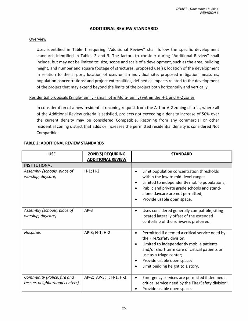
ADDITIONAL REVIEW STANDARDS
Overview
Uses identified in Table 1 requiring “Additional Review” shall follow the specific development
standards identified in Tables 2 and 3. The factors to consider during “Additional Review” shall
include, but may not be limited to: size, scope and scale of a development, such as the area, building
height, and number and square footage of structures; proposed use(s); location of the development
in relation to the airport; location of uses on an individual site; proposed mitigation measures;
population concentrations; and project externalities, defined as impacts related to the development
of the project that may extend beyond the limits of the project both horizontally and vertically.
Residential proposals (Single-family - small lot & Multi-family) within the H-1 and H-2 zones
In consideration of a new residential rezoning request from the A-1 or A-2 zoning district, where all
of the Additional Review criteria is satisfied, projects not exceeding a density increase of 50% over
the current density may be considered Compatible. Rezoning from any commercial or other
residential zoning district that adds or increases the permitted residential density is considered Not
Compatible.
TABLE 2: ADDITIONAL REVIEW STANDARDS
USE ZONE(S) REQUIRING ADDITIONAL REVIEW
STANDARD
INSTITUTIONAL
Assembly (schools, place of worship, daycare)
H-1; H-2 Limit population concentration thresholds within the low to mid- level range;
Limited to independently mobile populations;
Public and private grade schools and stand-alone daycare are not permitted;
Provide usable open space.
Assembly (schools, place of worship, daycare)
AP-3 Uses considered generally compatible; siting located laterally offset of the extended centerline of the runway is preferred.
Hospitals AP-3; H-1; H-2 Permitted if deemed a critical service need by the Fire/Safety division;
Limited to independently mobile patients and/or short term care of critical patients or use as a triage center;
Provide usable open space;
Limit building height to 1 story.
Community (Police, fire and rescue, neighborhood centers)
AP-2; AP-3; T; H-1; H-3 Emergency services are permitted if deemed a critical service need by the Fire/Safety division;
Provide usable open space.
DRAFT - December 18, 2014 REVISION 6
25
USE ZONE(S) REQUIRING ADDITIONAL REVIEW
STANDARD
Vertical Infrastructure (Electric Transmission, Water Towers, Telecommunication Towers)
AP-T; H-1; H-2; H-3; C Permitted if it does not interfere with airport communications and does not exceed height limitations, or otherwise causes safety concerns;
Monopole type of structure is preferred over lattice or guy-wire type;
Consider the height of the tower in relation to the site elevation.
RESIDENTIAL
Single-Family - Rural (1-3+ Acres)
AP-2; AP-3; H-1; H-2; H-3
Encourage clustering with usable open space requirement;
Encourage TDR program participation as a sending area;
Require real estate disclosure notice on initial deed of transfer within the AP-2, H-1, H-2, and H-3 zones;
Require notification statement on all plans of development and marketing literature;
Encourage noise mitigation measures as part of construction if under the flight pattern to reduce internal noise levels at or below 45dB.
Single-family - Small Lot (less than 1 acre) & Townhomes
AP-3 Encourage clustering with usable open space requirement;
Minimum of 50 percent overall open space, including usable open space;
Require notification statement on all plans of development and marketing literature.
Single-family - Small Lot (less than 1 acre) & Townhomes
H-1, H-2 Use prohibited within 3000 feet of the centerline of the runway;
Areas of a proposal located within routine overflight zone should meet the usable and site open space requirements;
Development should be clustered outside of the overflight zone area;
Require real estate disclosure notice on initial deed of transfer;
Require notification statement on all plans of development and marketing literature;
Encourage noise mitigation measures as part of construction if under the flight pattern.
DRAFT - December 18, 2014 REVISION 6
26
USE ZONE(S) REQUIRING ADDITIONAL REVIEW
STANDARD
Multi-Family (Three or more units per building)
AP-3; H-1; H-2 Use prohibited within 3000 feet of the centerline of the runway;
Areas of a proposal located within routine overflight zone traffic pattern should be utilized to meet the usable and site open space requirements within a residential development; Cluster residential density outside of the overflight area if feasible;
Limit number of units per building;
Limit height to three stories;
Require real estate disclosure notice on initial deed of transfer within the H-1 and H-2 zones;
Require notification statement on all plans of development and marketing literature;
Encourage noise mitigation measures as part of construction if under the flight pattern.
Group Living (Nursing homes, group homes)
AP-3; H-1; H-2 Population concentration thresholds within low to mid-level range shall not be exceeded;
Limited to independently mobile patients;
Require notification statement on all plans of development and marketing literature.
Transient Lodging AP-2; H-3 Use should not exceed a height of 3 stories;
Population concentration thresholds within low to mid-level range shall not be exceeded;
Encourage noise mitigation measures as part of construction if under the flight pattern;
Parking lot lighting shall not be linear in design to avoid confusion with runway lighting.
Transient Lodging H-1; H-2 Use should not exceed a height of 3 stories;
Population concentration limits for site and single-acre shall not be exceeded;
Encourage noise mitigation measures as part of construction if under the flight pattern;
Parking lot lighting shall not be linear in design to avoid confusion with runway lighting.
DRAFT - December 18, 2014 REVISION 6
27
USE ZONE(S) REQUIRING ADDITIONAL REVIEW
STANDARD
COMMERCIAL (RETAIL/OFFICE)
General Retail & Service (shopping centers & stores, restaurants, convenience, vehicle fueling)
AP-2; T; H-1; H-3 Population concentration limits for site and single-acre shall not be exceeded;
Larger shopping centers should provide usable open space;
Parking lot lighting shall not be linear in design to avoid confusion with runway lighting.
Automobile related (sales lot, repair, storage)
T Limited to vehicle storage or open space;
Parking lot lighting shall not be linear in design to avoid confusion with runway lighting.
Low-rise Office (1-3 stories) AP-2;AP-3; T; H-1; H-3 Provide usable open space requirements;
Maximum population thresholds shall not be exceeded;
Parking lot lighting shall not be linear in design to avoid confusion with runway lighting.
Mid/High-rise Office (4+ stories)
AP-3; H-1; H-2 Population concentration limits for site and single-acre shall not be exceeded;
Consider limitations to building height based on the elevation of the site and proximity to the airport and flight patterns;
Parking lot lighting shall not be linear in design to avoid confusion with runway lighting.
INDUSTRIAL
Light (light manufacturing, storage, warehouse)
AP-2; T; H-1 Low level of population concentration limits shall not be exceeded;
Compatible without externalities;
Provide usable open space;
Parking lot lighting shall not be linear in design to avoid confusion with runway lighting.
Heavy (landfill, heavy manufacturing, mining, uses that emit smoke or create sun glare)
AP-T; H-1; H-2; C; H-3 Compatible without externalities;
Provide usable open space;
Utilities that affect public health, safety and welfare not permitted within 4,000 feet of the runway;
Consider limitations to structure height based on the elevation of the site and proximity to the airport and flight patterns;
Parking lot lighting shall not be linear in design to avoid confusion with runway lighting.
DRAFT - December 18, 2014 REVISION 6
28
USE ZONE(S) REQUIRING ADDITIONAL REVIEW
STANDARD
RECREATION AND OPEN SPACE
Passive (trails & natural areas) AP-2; H-3 Avoid the incorporation of elements, vegetation and/or materials that attract birds,
Limit water retention areas to no greater than .5-acres;
Limit height and types of new and existing vegetation in accordance with the FAR Part 77 requirements.
Active (community sports fields, golf, indoor facilities)
AP-2; AP-3; H-1; H-3 Population concentration limits for site and single-acre shall not be exceeded;
Limit water retention areas to no greater than .5-acres;
Avoid new features, vegetation and/or materials that attract birds.
Amusement (Stadiums, amusement parks, fairgrounds)
AP-3; H-1; H-2 Compatible with increased open space;
Within population concentration limits for site and per acre;
High intensity uses, such as stadiums, are not permitted;
Parking lot lighting shall not be linear in design to avoid confusion with runway lighting.
DRAFT - December 18, 2014 REVISION 6
29

POPULATION CONCENTRATION THRESHOLDS
The population concentration threshold ranges referenced in Table 2 are further defined below. These
serve as a measurement tool to determine whether the population density for a given use may be too
intense for a particular zone.
TABLE 3: POPULATION CONCENTRATION THRESHOLDS
ZONE(S)
SITEWIDE AVERAGE INTENSITY*
SINGLE-ACRE INTENSITY**
AP-1 Sitewide Intensity: Exceptions can be permitted for agricultural activities, roads, and automobile parking provided that FAA criteria are satisfied
AP-2 Sitewide Intensity: Low to Mid: 40 - 50 people per acre Mid to High: 51 - 60 people per acre
Single-Acre Intensity: Low to Mid: 80 -100 people per acre Mid to High: 101 -120 people per acre
T Sitewide Intensity: Low to Mid: 70 - 85 people per acre Mid to High: 86 -100 people per acre
Single-Acre Intensity: Low to Mid: 210 - 255 people per acre Mid to High: 256 - 300 people per acre
H-1; H-2 Sitewide Intensity: Low to Mid: 200 - 250 people per acre Mid to High: 251 - 300 people per acre
Single-Acre Intensity: Low to Mid: 800 - 1000 people per acre Mid to High: 1001 - 1200 people per acre
H-3 Sitewide Intensity: Low to Mid: 70 - 85 people per acre Mid to High: 86 - 100 people per acre
Single-Acre Intensity: Low to Mid: 210 - 255 people per acre Mid to High: 256 - 300 people per acre
Source: California Airport Land Use Planning Handbook (Handbook) released October 2011 by the
California Department of Transportation, Division of Aeronautics.
*Sitewide Average Intensity: calculated by determining the total number of people expected to be on
the site at any given time under normal conditions and dividing by the total number of acres of the
project site.
** Single-Acre Intensity: calculated by determining the total number of people expected to be within
any one-acre portion of the site at one time.
DRAFT - December 18, 2014 REVISION 6
30

STAFFORD REGIONAL AIRPORT SAMPLE REAL ESTATE DISCLOSURE STATEMENT
The following is a sample disclosure statement that is recommended to be incorporated into the initial
sale of new homes located within the Airport Impact Areas:
STAFFORD REGIONAL AIRPORT DISCLOSURE
The purchaser(s) of property at the following address: , on Assessor’s
Parcel , located in Stafford County Virginia, hereafter referred to as “property”,
acknowledges that the property lies in proximity to Stafford Regional Airport, and that the property is
subject to aircraft operations and aircraft overflight, with related noise and safety concerns.
While air traffic may be generalized into tracks, it is, by nature, dispersed. Aircraft may approach and
depart the airport from any number of directions. Flight paths vary depending on a variety of factors
including origin/destination, wind conditions and other aircraft in the traffic pattern. As a result, any
property in the vicinity of an airport is likely to be subject to aircraft overflight and its impacts to some
degree. Stafford County’s Comprehensive Plan has an exhibit that depicts the aircraft traffic patterns
associated with the airport.
Flight patterns may shift or change over time. Changes in operations may occur due to weather, changes
in users, changes in aircraft type, military missions, weather conditions, etc. The airport is relatively new
and still growing. Runway expansion and expansion of ground facilities are planned that will likely
increase the number of flights in and out of the airport. The Stafford Regional Airport has a Master Plan
that identifies plans for future expansion and development needs.
The undersigned purchaser(s) of said tract of land certify(ies) that he/she (they) has (have) read the
above disclosure statement and acknowledge(s) the pre-existence of the Stafford Regional Airport and
the noise exposure due to the airport.
Dated this day of , 20 .
Purchaser’s Signature
Purchaser’s Signature
Purchaser’s Signature
DRAFT - December 18, 2014 REVISION 6
31
STAFFORD REGIONAL AIRPORT SAMPLE NOTICE
For full disclosure of the proximity to Stafford Regional Airport to prospective purchasers, the following
sample notice should be included on all subdivision and site plans and record plats filed with Stafford
County and used in sales contracts, brochures and promotional documents, including any illustrative site
plans, and homeowner’s association documents:
“STAFFORD REGIONAL AIRPORT: This property is located within the proximity to Stafford
Regional Airport, specifically the Airport Impact Areas and Aircraft Traffic Pattern areas around
the airport, as identified in the Stafford County Comprehensive Plan and Stafford Regional
Airport Master Plan. The property is likely to be subject to aircraft overflight and noise impacts
of varying degrees.”
DRAFT - December 18, 2014 REVISION 6
32