from east to west - rossendale borough council main … · this process not only met the...
TRANSCRIPT

From East to wEst making rossendale the Best
Core Strategy Development Plan Document: The Way Forward (2011 - 2026) Adopted 8th November 2011

Chapter 1 – Consultation and History of the Core Strategy 6Chapter 2 – Context and Background 14Chapter 3 – Rossendale in 2026, Spatial Vision and Strategic Objectives 26Chapter 4 – Area Vision Policies 32
aVP 1 whitworth, Facit and shawforth 36
aVP 2 Bacup, stacksteads, Britannia and weir 40
aVP 3 waterfoot, Lumb, Cowpe and water 44
aVP 4 rawtenstall, Crawshawbooth, Goodshaw and Loveclough 48
aVP 5 south west 52
aVP 6 Haslingden and rising Bridge 56
Chapter 5 – Topic Planning Policies 60Policy 1 General Development Locations and Principles 63
Policy 2 meeting rossendale’s Housing requirement 67
Policy 3 Distribution of additional Housing 71
Policy 4 affordable and supported Housing 74
Policy 5 meeting the Needs of Gypsies, travellers and travelling showpeople 75
Policy 6 training & skills 77
Policy 7 social Infrastructure 78
Policy 8 transport 80
Policy 9 accessibility 82
Policy 10 Provision for Employment 84
Policy 11 retail & other town Centre Uses 86
Policy 12 the Valley Centre 93
Policy 13 Protecting Key Local retail 94
Policy 14 tourism 95
Policy 15 overnight Visitor accommodation 98
Policy 16 Preserving & Enhancing the Built Environment 99
Policy 17 rossendale’s Green Infrastructure 100
Policy 18 Biodiversity, Geodiversity and Landscape Conservation 104
Policy 19 Climate Change and Low and Zero Carbon sources of Energy 106
Policy 20 wind Energy 108
Policy 21 supporting the rural Economy and its Communities 110
Policy 22 Planning Contributions 112
Policy 23 Promoting High Quality Designed spaces 114
Policy 24 Planning applications requirements 116
Chapter 6 - Delivery Mechanisms and Risk 118Sustainability Appraisal and Habitats Regulation Assessment 125Appendix One: Parking Standards 128Glossary 139
Contents
Phot
o: Ian
Laws
on
2
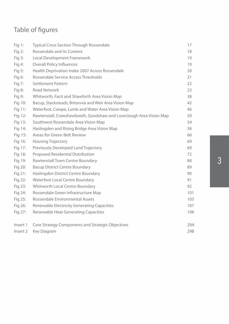
Fig 1: Typical Cross Section Through Rossendale 17Fig 2: Rossendale and its Context 18Fig 3: Local Development Framework 19Fig 4: Overall Policy Influences 19Fig 5: Health Deprivation Index 2007 Across Rossendale 20Fig 6: Rossendale Service Access Thresholds 21Fig 7: Settlement Pattern 22Fig 8: Road Network 23Fig 9: Whitworth, Facit and Shawforth Area Vision Map 38Fig 10: Bacup, Stacksteads, Britannia and Weir Area Vision Map 42Fig 11: Waterfoot, Cowpe, Lumb and Water Area Vision Map 46Fig 12: Rawtenstall, Crawshawbooth, Goodshaw and Loveclough Area Vision Map 50Fig 13: Southwest Rossendale Area Vision Map 54Fig 14: Haslingden and Rising Bridge Area Vision Map 58Fig 15: Areas for Green Belt Review 66Fig 16: Housing Trajectory 69Fig 17: Previously Developed Land Trajectory 69Fig 18: Proposed Residential Distribution 72Fig 19: Rawtenstall Town Centre Boundary 88Fig 20: Bacup District Centre Boundary 89Fig 21: Haslingden District Centre Boundary 90Fig 22: Waterfoot Local Centre Boundary 91Fig 23: Whitworth Local Centre Boundary 92Fig 24: Rossendale Green Infrastructure Map 101Fig 25: Rossendale Environmental Assets 103Fig 26: Renewable Electricity Generating Capacities 107Fig 27: Renewable Heat Generating Capacities 108
Insert 1 Core Strategy Components and Strategic Objectives 29AInsert 2 Key Diagram 29B
Table of figures
3

C O R E S T R AT E G Y
How to Use this DocumentThe Way Forward (Core Strategy) is made up of three main parts:
1. The Spatial Vision and Strategic Objectives
Set out what Rossendale will be like in 2026 after this plan has been successfully implemented and achieved.
From this vision, 8 objectives are proposed which cover the main issues for Rossendale and set out how the planning process for the next 15 years will address the issues identified as well as improve and deliver them.
2. Area Visions and Policies
Are broad plans for parts of Rossendale and aim to provide some idea/degree of certainty about the future of local areas for local people, developers, investors and Rossendale Borough Council.
3. Topic Planning Policies
Stipulate where, when and how different types of development will be encouraged and what standards are expected. They also set out how our natural environment and built heritage will be protected from development and enhanced through contributions and improvements.
The diagram (below) illustrates how the Spatial Vision identifies a number of Strategic Objectives, which then set the principles and aims carried through and delivered by the Area Visions and Policies as well as the Topic Planning Policies which will ultimately achieve the Spatial Vision for Rossendale.
This approach to the Core Strategy means that issues and opportunities are considered at both the strategic Borough-wide and local community levels, making The Way Forward a meaningful and realistic planning document for the future of Rossendale, focused on delivery.
Spatial Vision
Topic Planning Policies
Strategic Objectives
Area Visions & Policies
4

C O R E S T R AT E G Y
Other Chapters and Relevant InformationGlossary – a glossary of terms and abbreviations can be found at the back of the document to help with many of the planning terms that are used throughout the document.
Accompanying Documents – alongside the Core Strategy there are a number of other documents which support its policies and set out some of the reasoning behind why certain decisions have been made and why some policies have not been included in the document.
Other accompanying documents include:
Core Strategy DPD Sustainability Appraisal - To ensure that all the economic, environmental and social impacts of the Core Strategy are fully considered a Sustainability Appraisal (SA)/Strategic Environmental Assessment (SEA) is required. Sustainability Appraisal has been integral to the preparation of the Core Strategy. Each of the Plan’s objectives, as well as each of the individual policies, has been assessed against 17 separate criteria by an independent consultant. The criteria covered a wide range of indicators covering economic, environmental and social impacts. As a result of recommendations made by the consultant a number of policies were subsequently modified by the Council and re-examined by the consultant as part of a cyclical process. This process not only met the requirements of the relevant regulations but helped to ensure that the published document is as robust and sound as is possible.
More information on the SA is available on page 127-129 and within the full Sustainability Appraisal report accompanying this Core Strategy.
Core Strategy DPD Habitat Regulations Assessment/ Appropriate Assessment - The Core Strategy has been screened under the Habitat Regulations (as amended in 2007) for its effect on European (or Natura 2000) nature conservation sites. Natura 2000 sites include Special Areas of Conservation (SACs), Special Protection Areas (SPAs) and Ramsar sites (protected wetlands). Sites within 25km of the Borough boundary have been considered for any direct or indirect impacts that development in Rossendale may cause.
Like the Sustainability Appraisal, the Habitat Regulations Assessment has been an important guide in developing and amending this Core Strategy. Although there are no European/Natura 2000 designated sites in Rossendale, it is important to consider the possible effects of this plan on those sites outside the Borough. These sites include:
• RochdaleCanalSAC;
• SouthPennineMoorsSAC;
• PeakDistrictMoors(SouthPennineMoorsPhase1) SPA;
• SouthPennineMoorsSPAand;
• BowlandFellsSPA
Where it was deemed that a planning policy had the potential to adversely affect one or more of these sites, the policy has been amended to either neutralise the effect or mitigate against it. This iterative process was significant when setting the housing targets and locations for the Borough.
More information on the HRA is available on page 127 or within the full Habitat Regulations Assessment report accompanying this Core Strategy.
Alternative Options document To keep The Core Strategy as concise and easy to read as possible much of the explanation and justification for the decisions taken have been put into this document including policies that you may have seen in earlier versions of the Core Strategy, and why they have not been taken forward in this document.
Evidence Base Documents – The Core Strategy must be based on facts, to ensure that key issues are identified and addressed and that what is written is capable of happening. Many studies and assessments have been undertaken to support and inform this Core Strategy. These evidence base documents include:
Strategic Housing Land Availability Assessment (SHLAA)
Strategic Housing Market Assessment (SHMA)
Employment Land Study
Retail and Town Centre Study
Strategic Flood Risk Assessment (SFRA)
Affordable Housing Viability Assessment (AHVA)
Open Space and Play Equipment Audit
South Pennine Renewable Energy Study
LandscapeCapacityStudyforWindDevelopmentintheSouth Pennines
Tourism Study
East Lancashire Railway Study
Gypsy and Traveller Area Assessment
5

CHaPtEr1Consultation1. This chapter of the Core Strategy looks at all the consultation that has happened on the earlier versions of the Core Strategy and sets out:
When consultation took place and on which version
How many representations/comments were received
The main topics and issues that were raised How the topics and issues have been
addressed
2. This brief overview outlines the journey of the Core Strategy, the comments received and the changes we have made as a result.
3. The chapter is broken down into two parts:
3.1 Public consultation responses – the comments and representations received from local residents, community and action groups, businesses, land owners, developers, architects and planning agents; and
3.2 Statutory body comments – organisations and companies who must be involved in the planning process such as:
Highways Agency Lancashire County Council – highways,
education etc East Lancashire Primary Care Trust (PCT) United Utilities – electricity and water Lancashire Police Lancashire Fire Brigade Environment Agency English Heritage Natural England Government Office North West Surrounding Districts and Local Planning
Authorities
4. his chapter only highlights the main points and issues raised by each of the groups to provide a snap shot of the representations and comments made.
5. A full list of all the specific comments made the Proposed Submission document are included within the Regulation 30(e) Statement.
Consultation and History of
the Core strategy
66
C O R E S T R AT E G Y: C H A P T E R 1
77

Consultation History6. The preparation of the Core Strategy has taken into account the views of the public and stakeholders at various stages of consultation. Where possible, the strategy seeks consensus. In reality there will be issues around which complete agreement cannot be achieved. Where this is the case, such issues are identified, and the approach taken justified.
6. A number of alternative options have been put forward at different consultation stages. Consultation began in 2005 with the Issues and Options Consultation, followed by the Preferred Options consultation, and then the subsequent Addendum Report on Preferred Options (2006). After taking external advice following the Addendum Report on Preferred Options consultation, it was decided that the Core Strategy should be reworked to facilitate greater public engagement and to ensure that the document and its evidence base were sound.
7. After progressing work on the new version of the Core Strategy in 2008, the Area Visions consultation was carried out in 2009 to introduce greater local specificity and relevance into the document. The Proposed Way Forward consultation, also held in 2009, received a large response from both the public and stakeholders, and led to some significant changes to existing policies and the introduction of three new policies (Policies 17, 18 and 19). In 2010, a Bespoke consultation was held, which sought opinion on the policies which had either been created or significantly altered following the previous consultation event (The Proposed Way Forward – 2009). The Proposed Submission Publication document was subject to a formal 6 week consultation that concluded on the 1st November 2010. The following table charts the progression of the Core Strategy through the various consultation stages:
Consultation Event Dates No. of responses
Issues and Options consultation Dec-Jan2005/06 8Preferred Options consultation Apr-May 2006 31Addendum Report on Preferred Options consultation
Oct-Nov 2006 27
Core Strategy preparation restarted
2008 N/A
Area Visions consultation Jan-Aug2009 149The Proposed Way Forward consultation
Nov-Dec2009 79 (a) / 1087 (b)
Bespoke consultation May-Jun2010 13Publication consultation Sept-Nov 2010 32
N.B. Responses to The Way Forward consultation consisted of both formal letters (a) and informal comment slips (b)
Initial Consultations8. Initial consultations on the Core Strategy (Issues and Options, Preferred Options and Addendum Report on Preferred Options) covered a wide range of issues concerning all parts of the document;howevertherewerenodominantthemesbroughttolight. Nevertheless several comments were received concerning settlement hierarchy, town and village boundaries, planning gain and affordable housing provision. These issues have been fully addressed and incorporated into subsequent versions of the Core Strategy–namelyinPolicy1:GeneralDevelopmentLocations,Policy 22: Planning Contributions, and Policy 4: Affordable and Supported Housing. The Addendum Report on Preferred Options consultation raised concerns over Gypsy and Traveller accommodation, which have now been addressed in Policy 5: Meeting the Needs of Gypsies, Travellers and Travelling Show People.
9. The amount of evidence gathered and its robustness was also questioned during this consultation period. As a result significant work has been undertaken to ensure that the essential pieces ofevidencetosupporttheLDFarerobust.Theseevidencedocuments have informed the Core Strategy plans and policies.
10. These documents include the Strategic Housing Land Availability Assessment (SHLAA), Strategic Housing Market Assessment (SHMA), Employment Land Study, Retail and Town Centre Study, Strategic Flood Risk Assessment (SFRA), Affordable Housing Viability Assessment (AHVA), Tourism Study, LandscapeCapacityStudyforWindEnergyDevelopmentintheSouth Pennines, Renewable and Low Carbon Energy Study and an Open Space and Play Equipment Audit. A number of these studies and assessments incorporated individual steering groups and consultation seminars/events to ensure that the key issues identified in previous versions of the Core Strategy were not overlooked as the evidence was updated.
Area Visions Consultation11. To make the Core Strategy as relevant to Rossendale and its highly distinct places as possible, Area Visions were produced for eight (later consolidated to six) areas covering the entire Borough to assess local issues and opportunities and set out possible options to suitably address them. 149 representations werereceivedbetweenJanuaryandAugust2009,whichshapedthe structure and content of the Area Vision policies, and their relationship to other policies within the Core Strategy. The following chart displays the main issues that generated public concern across the Borough, chiefly:
• Respectforlocalheritageanditspreservation
• Conservationofthenaturalenvironmentandgreenspaces
• Safeguardinglocaljobsandcreatingneweconomicopportunities
• Improvementofbuildingdesigns
C O R E S T R AT E G Y: C H A P T E R 1
8

12. In addition, further discussion and analysis of public consultation responses revealed major concerns over:
Infrastructure Capacity and Location of New Residential Development
13. Many of the comments centred on concerns that existing infrastructure may be incapable of accommodating increased levels of development. In particular, concerns were raised over the amount of new housing proposed and how this would impact upon the congestion of local roads, and the number of available school places. Research has been undertaken to assess both the capacities of existing infrastructure and any plans for future infrastructure provision, including identifying any funding gaps. With this information, the Council and service/utility providers can strategically align investment and ensure that new development is appropriately timed and located. Policy 8: Transport and Policy 22: Planning Contributions now address these issues, and strategic reviews will continue over the lifetime of the Core Strategy.
Greenfield Development
14. Representations on new residential development were mainly concerned with where it was to be located and the development of greenfield sites rather than existing previously developed sites. National policy encourages Local Authorities to locate new residential development on previously developed land where possible;andplanningobligationsandtheproposedtariff-basedlevy system make it possible for Local Planning Authorities to collect funds towards infrastructure projects. Policy 1: General DevelopmentLocations,Policy2:MeetingRossendale’sHousingNeeds, and Policy 22: Planning Contributions now address these issues.
Local Built Heritage and Conservation
15. In particular, concerns were raised about the importance of the built heritage in Bacup, which is recognised as the best preserved mill town in the country. Following discussions
with the Council’s conservation officer and advice from English Heritage,Policy1:GeneralDevelopmentLocations,Policy16:Preserving and Enhancing the Built Environment and Area Vision Policies 1-6 have been amended to fully address these issues.
Countryside and Landscape Protection/Development
16. Alongside more general concerns regarding landscape protection, responses discussed what kinds of development would be acceptable in countryside areas, especially given the potential tourism and recreation attractions. Policy 17: Rossendale’s Green Infrastructure. Policy 18: Biodiversity, Geodiversity and Landscape Conservation. Policy 14: Tourism and Policy 15: Overnight Visitor Accommodation now address these issues in full.
The Proposed Way Forward Consultation17.HeldduringNovemberandDecember2009,TheProposedWay Forward consultation gave the public and stakeholders a chance to comment on the Core Strategy document in its entirety. This was either through formal written representations, or through discussion and comments slips at 9 consultation events held throughout the Borough in libraries, markets and supermarkets. A total of 79 formal written representations and 1087 comments slips were received, the majority of which were supportive of the progress made on the Core Strategy document, and welcomed the changes and local specificity incorporated through the previous Area Visions consultation.
18. The following chart details the ten most common points raised at The Proposed Way Forward consultation events:
The Valley Centre
19. The importance of the need to redevelop The Valley Centre led to the strengthening of Policy 12 in terms of priority for action and the requirement for high quality design, and has fed into the appointment of a consortium of consultants headed by Building DesignPartnershiptoproduceamasterplanandframeworkforthe future redevelopment of the site.
(Figures from Area Visions Consultation Exercise, 2009)
(Figures from The Way Forward consultation, 2010)
The Valley Centre Commuter Rail Link is important Need more local shops / variety Tourism is important / need
events for tourists Need better car parking
Provide New Houses
EncourageNewDevelopment
New Rail Link
PromoteLocalJobs
Need more facilities for young people Protect / enhance the countryside Whitworth has a good community spirit /
is a nice town Too many hot food takeaways Keep Bacup Leisure Hall open
Encourage Local Businesses
ImproveBuildingDesigns
Protect Our Heritage
Conserve Our Environment
87
59
3030
8%5%
9%
13%
12%15%
18%
20%
29
27
24
24
20 18
C O R E S T R AT E G Y: C H A P T E R 1
9
Climate Change and Conservation
20. Representations particularly from Natural England, 4NW, Lancashire County Council and the Lancashire Wildlife Trust, raised concerns over biodiversity, Green Infrastructure provision, landscape conservation and the overall approach to climate change. Through subsequently working with these partners, the Council introduced three new policies Policy 17: Rossendale’s Green Infrastructure, Policy 18: Biodiversity, Geodiversity and Landscape Conservation, and Policy 19: Climate Change and Low and Zero Carbon Energy to fully address any weaknesses identified, and give clearer direction for the development of renewable energy and the conservation of natural assets in the Borough.
Housing Deliverability
21. Concerns were also raised, mainly by developers, about the provision of housing on brownfield sites (versus greenfield sites) and the deliverability of housing in line with the settlement hierarchy as identified in The Proposed Way Forward document. Whilst the Council maintains its commitment to delivering approximately 65% of housing on brownfield land (in line with generalpublicopinion),Policy3:DistributionofAdditionalHousing was amended following the consultation – placing an increased percentage of new residential developments in the Bacup, Haslingden and Whitworth areas, thereby reducing the pressure on Rawtenstall and particularly the Borough’s smaller settlements. The amended distribution framework will also make the commitment to achieve brownfield land targets more tenable.
Bespoke Consultation22.BetweenMay–June2010,aspecialconsultationwascarriedout solely on policies which had either been newly created or where amendments could be considered to be significant since consultation on The Proposed Way Forward. This gave respondents a chance to check that the changes that had been made reflected their original concerns. A total of 13 responses were received, mainly voicing support for the new policies (Policies 17, 18 and 19), and suggesting minor amendments to the text where necessary.
Proposed Submission Consultation23. Between September and November 2010 a consultation was undertaken on the Soundness and Legal Compliance of the document. A total of 32 responses were received, many of which supported the document. The main concerns raised related to housing provision.
Professional Body Responses24. In order to ensure that the Core Strategy reflects and complements the aspirations of our partners, it is important to work closely with key stakeholders. Successful delivery of the
development plan is dependent on many bodies supporting and working towards common goals. This has been achieved through meetings and correspondence with key partners and stakeholders throughout all stages of the preparation of this plan to ensure compliance with other strategies and documents.
Infrastructure
25.Detaileddiscussionshavebeenheldwiththeutilityandservice providers to:
Identify and map areas where current provision is lacking or under stress
Identify current provision and proposed provision over the lifetime of the plan
Ensure providers are aware and can prepare for future requirements.
26. Based on discussions with key providers, the provision of infrastructure will not constrain development identified in the Core Strategy.
27. The importance of planning obligations and the proposed Community Infrastructure Levy as mechanisms to contribute towardsnew/improvedinfrastructureisrecognised.Duetothenew system not being confirmed as of yet, the exact approach to be taken in Rossendale is not yet determined.
Transport
28. The East Lancashire Railway is a key underused asset in Rossendale. It currently has an important tourist role which the Railway Company is keen to develop through station enhancements and better links to the town centres of Rawtenstall and Bury. However, there is also potential to develop a commuter rail link delivering a 35 minute service to Manchester. This is supported by the railway. Ongoing studies funded by the Greater Manchester Integrated Transport Authority are examining the feasibility of developing such a scheme. These will also consider bus enhancements and “Park and Ride” options along the railway line.
29. The A56/M66 forms the main road link into the Borough. The Highways Agency has indicated support for initiatives to reduce dependency on car travel and efforts to increase cycling and walking in the Borough. The amount of out-commuting from Rossendale towards Manchester contributes to traffic congestion on the M66 and junction 18 of the M62/M60. The Highways Agency is working with Rossendale and other authorities to examine methods to better manage the existing motorway including through use of the hard shoulder for both buses and cars.
30. Lancashire County Council is the Highway Authority for all other roads, cycleways and public transport in the Borough. It is considering options for a new bus station in Rawtenstall and has identified ways to improve the cycleway network. Projects and ongoing maintenance countywide are funded through the Local
C O R E S T R AT E G Y: C H A P T E R 1
10

Transport Plan (LTP). A new Local Transport Plan (LTP3) will come into operation in 2011.
Water
31. United Utilities deliver the water supply and waste water treatment across Rossendale, with the Environment Agency having responsibility for flood and pollution prevention. United Utilities have confirmed that there are no capacity issues either for treatment works or sewers and that their Forward Plan will address surface water run-off issues through new storage facilities in Stacksteads and Rawtenstall.
Flood Risk
32. In accordance with Planning Policy Statement (PPS) 25 a Strategic Flood Risk Assessment (SFRA) has been undertaken to identify areas at risk of flooding across the Borough. The study identified that 2.6% of Rossendale falls within Flood Zones 2 and 3. The SFRA Flood Zones show the areas that are potentially at risk of flooding are along narrow strips of land immediately adjacent to watercourses, which is due to the well defined channels of the watercourses, their general steepness and relatively small sizes. Urban locations within the study area that are potentially affected by flooding include parts of Bacup, Haslingden, Rawtenstall and Whitworth. There are some cross-border issues with Bury in the south-west of the Borough as well as significant associated flood risks in Salford as a result of the River Irwell. In addition, there are numerous smaller settlements in the study area that have areas at risk of surface water flooding. United Utilities are in the midst ofundertakingaseriesofUnsatisfactoryIntermittentDischarge(UID)projectsinStacksteads,andinRawtenstallatBankStreet,
St Mary’s Way, Bacup Road/Marcross Street, Bacup Road/Highfield Road and Holmebridge to alleviate the amount of surface water runoff entering the local river system. The Environment Agency is also working with the Lancashire County Council, and other partners to ensure that flood risk is carefully managed. Developmentproposedinspecificareasofriskwillbesubjectto detailed assessment. In general, although flood risk exists in some areas, it does not pose a widespread issue and no particular flooding concerns were identified that would prejudice the overall delivery of the Core Strategy.
Green Infrastructure
33. This can be defined as a network of woodlands, rivers, natural landscapes, countryside and other types of natural features which conserve habitats for plants and animals. Green Infrastructure has many important roles such as reducing flood risk, improving local air quality and providing walking and exercise opportunities for local residents. Lancashire Economic Partnership have recently completed an audit of the county on this topic.
34. The Open Space Audit (2008) concluded that there was no fundamental shortfall of open space in Rossendale. Localised shortfalls could be addressed by the re-use of existing spaces and an improvement in quality of some of the existing areas. This will require funding being obtained from a variety of sources including planning obligations.
Electricity and Gas
35. United Utilities and National Grid are responsible for the supply of electricity across the Borough. National Grid manages thegasnetwork.Discussionshavebeenheldtoensuresufficient
C O R E S T R AT E G Y: C H A P T E R 1
11
Education
41. There has been significant recent investment in education facilities in the Borough, such as the development of sixth form facilities at Alder Grange High school near Rawtenstall and a new eco-friendlyprimaryschoolatWaterfoot.Duetotheeconomicdownturn ambitious plans to rebuild all of the Borough’s secondary schools have been dropped but new forms of school governance proposed nationally may create new opportunities to improve existing facilities. A proposal to build a vocational training facility in the Bacup area is regarded as a priority that will require a partnership approach to deliver.
Police
42. There are currently proposals to establish a new access point onJamesStreetinBacupwhichhasresultedintheclosureofthe existing Police Station. The continued use of facilities in Rawtenstall will be kept under review as part of the future development of the Valley Centre.
Fire Brigade
43. There are currently fire stations in Rawtenstall, Bacup and Haslingden. The level of cover varies from station to station with Rawtenstall forming the main 24 hour facility. Existing arrangements are reviewed every three years.
supply capacity is available for proposed growth. There is a need to reinforce elements of the existing network but there are no identified constraints that would affect implementation of the Core Strategy.
Telecommunications
36. BT Openreach is responsible for supply and management of the landline network. A major upgrade is being undertaken nationally to improve the speed of the network, especially the upgrading of cabinets and cables to allow high speed broadband. The intention is to roll this out by 2012/13. In March 2010 the Government published a Report on Next Generation Access (superfast broadband) which identified those areas in the UK most likely to require government intervention to ensure the necessary improvements. The report addressed both technical issues and the impact on social exclusion and rurality of superfast broadband provision. If the target of 90% of homes having Next Generation Access by 2017 is to be met it will require significant investment in parts of Rossendale, including around Bacup/Stacksteads/Weir and around Edenfield.
37. Mobile phone operators have a one year plan of investment in new masts and are unable to provide information further ahead. New masts will be required where there is a poor signal and/or current high demand but this will primarily be a consolidation of the existing network.
Health
38. Regular stakeholder meetings are held with the PCT through the Local Strategic Partnership. The Group shares information on respective planning processes and seeks to ensure that there is a correlation between future development and new health infrastructure investment. The East Lancashire Primary Care Trust (PCT) has invested in improving infrastructure including the redevelopment of Albion Mill, Rawtenstall, in a £10m programme to develop a health hub in Rossendale. This provides up to date facilities for the whole Borough including a base for the Hospice, though more acute cases will still need to travel to Burnley or Blackburn. Various mobile outreach facilities will be provided. The existing Rossendale Hospital has been closed. Whitworth Health Centre is managed by Rochdale PCT and will only require periodic upgrades through the Core Strategy period.
39. Mental Health Services are provided by Lancashire Care Trust. The main centre in Rossendale is at Balladen House, Rawtenstall which has recently been refurbished and will continue to serve the Borough. A new Intensive Care Facility for the whole of East Lancashire is proposed at Burnley Bridge, Hapton near Burnley.
Ambulance Services
40. Existing ambulance services are run by North West Ambulance Trust. The local base has been switched to the new Health Hub in Rawtenstall.
C O R E S T R AT E G Y: C H A P T E R 1
12
C O R E S T R AT E G Y: C H A P T E R 1
13

CHaPtEr214
Context and Background
Context44. This chapter sets out the key influences on Rossendale, looking back at the history of the Borough through to the present day, highlighting key turning points, trends and events that have helped shape and define the Rossendale we know today.
45. It looks at both the strengths and weaknesses of the Borough and identifies its role within Lancashire, highlighting major influences and similarities with our neighbours, and the impact(s) that they have on Rossendale, and vice versa.
46. The chapter also outlines the key issues, opportunities and challenges facing Rossendale today and looks at facts and figures to demonstrate the key issues, which then form the basis of the rest of the plan.
47. Information in this chapter comes from many different national and regional sources plus specially commissioned Evidence Base documents such as those on employment and and retail uses in town centres.
14

1515

Geography and Connectivity48. Rossendale is one of the smallest boroughs in Lancashire covering an area of 138 sq kilometres with a population of 67,300. It is located in the south-east of the county and forms part of a group of authorities known as “Pennine Lancashire” which comprises of Burnley, Hyndburn, Pendle, Ribble Valley andBlackburnwithDarwen.Rossendaleisverymuchaborderauthority. The Borough is situated immediately north of Greater Manchester and only 18 miles from Manchester city centre. Rossendale is bounded by the metropolitan authorities of Bury (to the south-west) and Rochdale (to the south-east). Calderdale (to the east) forms part of the West Yorkshire conurbation.
49. Rossendale occupies a strategic location within the region, astride the M66/A56(T), linking the M60/M62 with the M65 motorway. This popular commuter route and the proximity to Manchester make Rossendale highly accessible and able to play an important role within the sub-region, acting as a gateway to Pennine Lancashire as a whole. Whilst the influence of Manchester as a centre for employment, shopping, leisure and other services is felt throughout the Borough, there are also strong links with other adjoining authorities, notably Bury, Burnley and Rochdale.
50. It is undoubtedly this proximity to Manchester and the other industrial centres of Pennine Lancashire as well as the unique topography of Rossendale that resulted in rapid change and development during the industrial revolution, as water from the Borough’s rivers and tributaries and coal largely brought in by rail were used to power mills supporting the textile, shoe and slipper industries. Moreover, it is also this accessibility, particularly to Manchester, that has resulted in significant amounts of new commuter housing in the west of the Borough being built in the last 25 years, particularly in areas such as Helmshore, Edenfield and Crawshawbooth.
51. The Borough is defined by a series of interlocking valleys dissecting open moorland, which has determined how the district has grown and developed over the years. A series of closely linked small towns line the valley floors, the largest being Rawtenstall and Bacup. Expansive long distance views are available from the uplands, with the Rights of Way network forming an important leisure resource both for local people and for those from further afield. Rossendale forms part of the broader South Pennine Landscape Character Area defined by Natural England (which includes the West Pennine Moors) stretching west towards Chorley and to the east, including parts of Calderdale, Burnley, PendleandBradfordDistricts.
52. Rossendale possesses one of the most complete historic environments in the Pennine Lancashire sub-region. Patterns of settlement in the Borough reflect the usefulness of different parts of the landscape to different groups over time, their activities separated by topography and geology. The evidence of farming, quarrying, mining and industry is organised in layers within the
steep sided valleys, following springlines, tracks, coal seams and river courses. The result is a landscape of contrasts, where different historic periods are identifiable and the juxtaposition of one historical type with another can be abrupt and memorable.
53. The Borough’s uplands have been extensively quarried over many years and continue to be so. Many of the buildings in the Borough are built from the local sandstone which gives the towns and villages in the area a distinct identity. A number of the disused quarries have seen re-use for leisure purposes, notably Lee Quarry, near Bacup which has become a major destination for mountain bikers.
Development and Deprivation
54. However like many other areas the rapid and intense development which occurred during the industrial revolution and subsequent decline in manufacturing has left a legacy of derelict and contaminated land and buildings (in particular mills), poor health, and low education attainment figures. There have been improvements in recent years but parts of Rossendale still show signs of deprivation.
55.Duringtheprocessofmovingonfromitsproudindustrialheritage, a tangible split separating the west of Rossendale from the east has occurred. The road connections in the west coupled with an attractive environment, protected in part by a Green Belt designation, means certain areas of Rossendale are desirable for commuting and as a result there are relatively high house prices to the north, south and west of the main town of Rawtenstall. Indeed, there are areas around Haslingden (with the exception of Haslingden centre which does have localised problems) and Rawtenstall that are categorised as being in the top 25% of least deprived areas nationally.
56. Conversely, the east of Rossendale has not developed and moved on to the same extent as the west and is regarded as the more deprived end of the Rossendale valley in socio-economic terms. This is predominantly due to perceived poor interconnectivity between Bacup and Rawtenstall resulting in a perception of isolation. In addition to poor access, the east is also the location for Rossendale’s Housing Market Renewal (HMR) Pathfinder. This covers Bacup, Stacksteads and Britannia and aims to deal with the issue of low house prices and poor demand in the area. There is a concentration of areas in the east of the Borough which are within the top 10% of most deprived areas in the country. As a result of poor access and desirability, the east of the Borough is lagging behind the west and much attention is needed to make it a successful and attractive place for people to live, work and visit.
Natural Environment
57. Rossendale contains some priority habitats listed on the UK Biodiversity Action Plan with the predominant habitats in the Borough being blanket bog with areas of upland Heath,
C O R E S T R AT E G Y: C H A P T E R 2
16
C O R E S T R AT E G Y: C H A P T E R 2
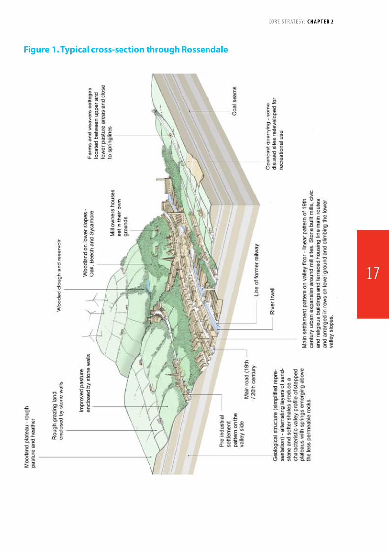
Figure 1. Typical cross-section through Rossendale
17

upland oak woodland, wet woodland and upland springs and flushes. Lower Red Lees Pasture in the south west of the Borough is in an unfavourable declining condition due to lack of appropriate grazing reducing species diversity. Hodge Clough is in a favourable condition though the condition of the woodland may deteriorate unless there is more intervention. Lee Quarry is managed for recreation and the site’s features are still visible, though more interpretation of its geological features should be considered.
58.HealeyDell,onthefarsoutheastborderwithRochdale,isthe Borough’s only Local Nature Reserve (LNR), with an area of 25ha. Government guidance states that Rossendale should have at least 67 ha of designated LNR – leaving a current shortfall of 42ha. Over the lifetime of the Core Strategy, the Council aims to address this shortfall by working towards formal designation of other sites.
59. There is considerable accessible countryside in and around Rossendale when assessed using Natural England classifications. There are 7 RIGGS sites in the Borough (Regionally Important Geological and Geomorphological Sites). The agricultural land qualityintheBoroughispoor;withsitesclassifiedatgrades4and 5 (i.e. the poorest grades), and generally used for grazing.
60. The recycling rate within Rossendale is similar to the national rate and better than some other Pennine Lancashire authorities, but at 34.5% this is well below the average for Lancashire at 41.2%.
Built Heritage
61. In terms of built heritage, there are currently 9 designated Conservation Areas within Rossendale, namely, Bacup Town
Centre (identified by English Heritage as a Conservation Area at risk), Chatterton/Strongstry, Fallbarn, Goodshawfold, Higher Cloughfold, Irwell Vale, Loveclough Fold, Rawtenstall Town Centre and Whitworth Square.
62. The Borough contains numerous historic buildings, including approximately 263 listed buildings - of which 2 are classed as being‘atrisk’(namelyGraneMillinHaslingdenandSt.John’sChurch in Crawshawbooth).
Policy Context
63. The Core Strategy forms only one part, albeit an important one, of the planning framework for Rossendale. It is one elementoftheLocalDevelopmentFramework(LDF),alibraryofdocumentsthatwillformtheDevelopmentPlanfortheBorough,as illustrated by Figure 3. The Core Strategy is an overarching document that sets the main direction and amount of development for the next 15 years. It puts into a physical form the content of the Sustainable Community Strategy (SCS). Together the Core Strategy and the SCS provide direction on how key issues affecting the Borough will be tackled over the next 10-15 years.
National, Regional and Sub Regional influence
64. Figure 4 shows the national, regional and sub-regional influencesontheLocalDevelopmentFrameworkforRossendale.ThedocumentsshowninboldformpartoftheDevelopmentPlan for Rossendale. At a national level the Government sets out planning principles through a series of Planning Policy Statements (PPS’s). The relevant principles have to be applied in the preparation of Core Strategies. These are being supplemented and ultimately replaced with a series of National Policy Statements.
Figure 2: Rossendale and its Context
C O R E S T R AT E G Y: C H A P T E R 2
18

Figure 3: The Local Development Framework
Figure 4: Overall Policy Influences
Local Development Framework
Local Development Scheme
Statement of Community Involvement
Core Strategy Site SpecificAllocations
Adopted Proposals Map
Area Action Plans
Other Development Plan Documents
Supplementary Planning Documents
Annual Monitoring Report
Key
Timescale
The timetable for preparing the planning documents oftheLocalDevelopmentFramework
Required documents
The Council is required by planning law to produce documents in this colour
Optional documents
The Council can choose to produce documents in this colour but they are not required by planning law.
65. The Northern Way is an initiative that covers the three northern regions including the North West and was instrumental in developing a number of policy principles including the concept of City Regions. Rossendale is situated in the Central Lancashire City Region. The Northern Way Vision has no statutory status but has been influential in some policy areas such as transport.
66. Although it is expected that the Regional Spatial Strategy for the North West will been revoked, an emerging document that considers development in the region “Future North West: Our Shared Priorities” has been prepared as a non-statutory document.
67. In addition Pennine Lancashire has submitted a bid to create a Local Economic Partnership, including the districts of Rossendale,
Burnley,RibbleValley,BlackburnwithDarwenandPendle.
68. The Local Transport Plan (LTP) for Lancashire produced by the County Council provides the framework for transport priorities and investment in the Borough. A revised document will come into operation in 2011.
69. All Minerals and Waste planning issues are dealt with throughthevariousJointLancashireMineralsandWasteLocalDevelopmentFrameworkdocumentspreparedjointlybyLancashireCountyCouncil,BlackburnwithDarwenandBlackpoolCouncils. They are therefore not addressed in this Core Strategy.
70. As well as the documents listed above many other documents form important sub-regional context for the Core Strategy. These include:
National
District
Planning Policy Statements
Planning Policy Guidance
Sustainable Community Strategy
Rossendale Core Strategy and Local Development Framework
Local Policy Documentse.g.Environmental Strategy
Pennine Lancashire Multi Area Agreement
Lancashire City Region DevelopmentProgramme
Lancashire Economic Strategy
Local Transport Plan
Joint Lancashire Minerals and Waste LDF
Pennine Lancashire Housing Strategy
Local Economic Partnership
Ambition Lancashire and Local Area Agreement PLUS OTHERS
Sub Regional
C O R E S T R AT E G Y: C H A P T E R 2
19

• LancashireEconomicStrategy/PennineLancashireEconomicStrategy
• CityRegionDevelopmentProgramme
• PennineLancashireSpatialGuide
• PennineLancashireHousingStrategy
• RightsofWayImprovementPlan
• WestPennineMoorsManagementPlan
• LancashireLandscapeandHeritageSPG
71. “Ambition Lancashire”, Lancashire Partnership’s Sustainable Community Strategy, was adopted in 2005 and revised by the partnership in 2008. The Partnership brought together local authorities, Primary Care Trusts, the Police, voluntary groups and a range of other bodies to produce the strategy. The targets and indicators in the Local Area Agreement (LAA) reflect and were informed by the priorities in “Ambition Lancashire”. The principles of ‘’Narrowing the gap’’ (deprivation, health, education, social cohesion) and “Active and Engaged Communities”, set out in Ambition Lancashire have also been applied to the development of targets and indicators in the LAA. The LAA contains 35 NI targets from the National Indicator Set (NIs) and some of these indicators have targets which are broken down to district level. These were agreed within the thematic groups and between the theme lead, LAA Co-ordinator, Government Office and central government. Each of these district level targets formed the Lancashire target (aggregated) but they are not additional to the 35 NI LAA indicators. Government funding (Performance Reward Grant) has been related to the delivery of these targets.
72. Another very important document is the Pennine Lancashire Multi Area Agreement (MAA). This establishes various investment
priorities agreed between the six local authorities in the area (Burnley,BlackburnwithDarwen,Hyndburn,Pendle,RibbleValley and Rossendale) and Central Government. Key priorities areasincludefundingarrangements:transportinitiatives;worklessness;broadbanddelivery;highereducation;planningand housing. A non statutory “Spatial Guide” is being produced. A key MAA priority for Rossendale is the plan to re-instate the commuter rail link to Manchester. Rossendale Borough Council is also a member of Regenerate Pennine Lancashire (formerly Elevate) which plays a key role in managing regeneration and housing improvements across the area. This enables issues of cross-border interest to be fully addressed.
73. As well as joint working with authorities in Lancashire, strong relationships exist with the adjoining metropolitan authorities. This includes landscape studies and renewable energy analysis as part of a consortium of South Pennine authorities including those in Greater Manchester and West Yorkshire. The East Lancashire Railway involves Rossendale engaging strongly with Bury, Rochdale and Greater Manchester Integrated Transport Authority to develop the potential of this important piece of infrastructure.
74. In addition to the above initiatives various partners have their own medium and long term plans, e.g. the Health Authorities and the Environment Agency. Rossendale Borough Council also has a number of Corporate Policy documents, such as the Environment Strategy, which have fed into preparation of the document.
Issues, Problems and Challenges/ Issues Facing Rossendale
Demographics
75. The total population of Rossendale was 67,300 in mid 2008 and in recent years growth has been minimal. However, forecasts
Worst 10% nationally
Worst 10% to worst 25% nationally
Worst 25% to worst 50% nationally
Best 50% nationally
HealthDeprivationIndex2007acrossRossendale
This map is reproduced from Ordnance Survey material with the permission of Ordnance Survey on behalf of the Controller of Her Majesty’s Stationery Office (C) Crown Copyright. Unauthorised reproduction infringes copyright and may lead to prosecution or civil proceedings. Lancashire County Council Licence Number 100023320
Figure 5
C O R E S T R AT E G Y: C H A P T E R 2
20

predict that the population of the Borough will increase by 6.3% over the next 15 years to approximately 71,300. Nonetheless, Rossendale has a significant local problem in retaining 20-24 year olds which make up only 4.84% of the population, lower than both the North West (5.79%) and England and Wales (6.01%). This indicates that large numbers of young people leave the area looking for better job opportunities elsewhere. There is however a relatively high proportion of young families compared to the regional trend. Life expectancy for men at 75.4 in Rossendale is amongst the worst in the country although the life expectancy for women at 81 is slightly greater than the regional average but still lower than the national figure (source ONS).
76. Levels of multiple deprivation are high compared to that of neighbouring areas. Rossendale is ranked as the 92nd most deprived authority out of 354 authorities. Levels of multiple deprivation are higher than that of the neighbouring unitary authorities of Calderdale and Bury, ranked 107th and 122nd respectively. Aspects of deprivation such as crime and employment show few extremes, but there is a high degree of health deprivation in the Borough with 20% of Super Output Areas (SOAs) being among the worst 10% in the country. Mental health problems and long-term sickness are particularly significant and are concentrated around Bacup, Stacksteads and Whitworth in the east as well as Haslingden in the west. However, overall Rossendale is less deprived than its Pennine Lancashire neighbours with the exception of Ribble Valley.
77. Crime rates in Rossendale are predominantly lower than both regional and national averages and it remains a comparatively safe borough to live in.
Economic Activity
78. Rossendale has had slow economic growth over the last
30 years, a result of the long term contraction of the Borough’s established local industries, such as textiles, clothing and footwear. This has left many sites underused or in need of remediation. Also the Borough has limited flat land available because of its topography, and many sites adjoin the River Irwell and are at risk of flooding, or are close to residential areas. The Employment Land Study (2009) notes that manufacturing within Rossendale has been more resilient than many other places, even within the region.
79. At 86% the Borough has a high proportion of very small firms, with 0 to 9 employees. (This is slightly higher than regional and national figures, of 82% and 83 % respectively). Rossendale has very few large firms with 0.9% having more than 100 employees. (This compares with 1.6% in the North West and 1.5% nationally). The largest private sector employers in the Borough, employing more than 250 people, and excluding retailers, are in manufacturing (floor underlay, filtration and screening products, and furniture). The manufacturing sector accounts for a much higher proportion of local employment than in the region. In the public sector, the Council employs 200 staff.
80. Rossendale over the period 1998 to 2007 saw a decrease in the number of employee jobs, similar to other Pennine Lancashire authorities, at a time when job numbers were increasing nationally and regionally. The number of VAT registrations has been increasing although at a lower rate than that for Lancashire, and survival rates for new businesses are slightly lower than county and regional averages (68% compared to 73% and 71%) though business start-ups have been improving and are more successful than the national picture.
81. Unemployment within Rossendale has traditionally been lower than regional and national averages. However, for a short period in 2009 the unemployment rate peaked, exceeding
All sevenSixFiveFourThreeTwoOneNone
Services include: Primary School Secondary SchoolFurther Education Employment Opportunity Hospital GPSupermarket
Rossendale Service Access Thresholds
Figure 6
This map is reproduced from Ordnance Survey material with the permission of Ordnance Survey on behalf of the Controller of Her Majesty’s Stationery Office (C) Crown Copyright. Unauthorised reproduction infringes copyright and may lead to prosecution or civil proceedings. Lancashire County Council Licence Number 100023320
C O R E S T R AT E G Y: C H A P T E R 2
21
Good
shaw
Risin
gBr
idge
Craw
shaw
boot
h
Love
cloug
h
Wat
er
Raw
tens
tall
Wat
erfo
ot
Bacu
p Whi
twor
thKe
y set
tlem
ent -
Core
nee
ds re
gene
ratin
g
Othe
r set
tlem
ent
Mai
n ur
ban
and
resid
entia
l are
as/c
orrid
ors
Mai
n in
dust
rial a
reas
/cor
ridor
s
Attra
ctiv
e and
ope
n co
untr
ysid
e
Hasli
ngde
n
Stac
kste
ads
Wei
r
Shaw
fort
h
Eden
field
Helm
shor
e
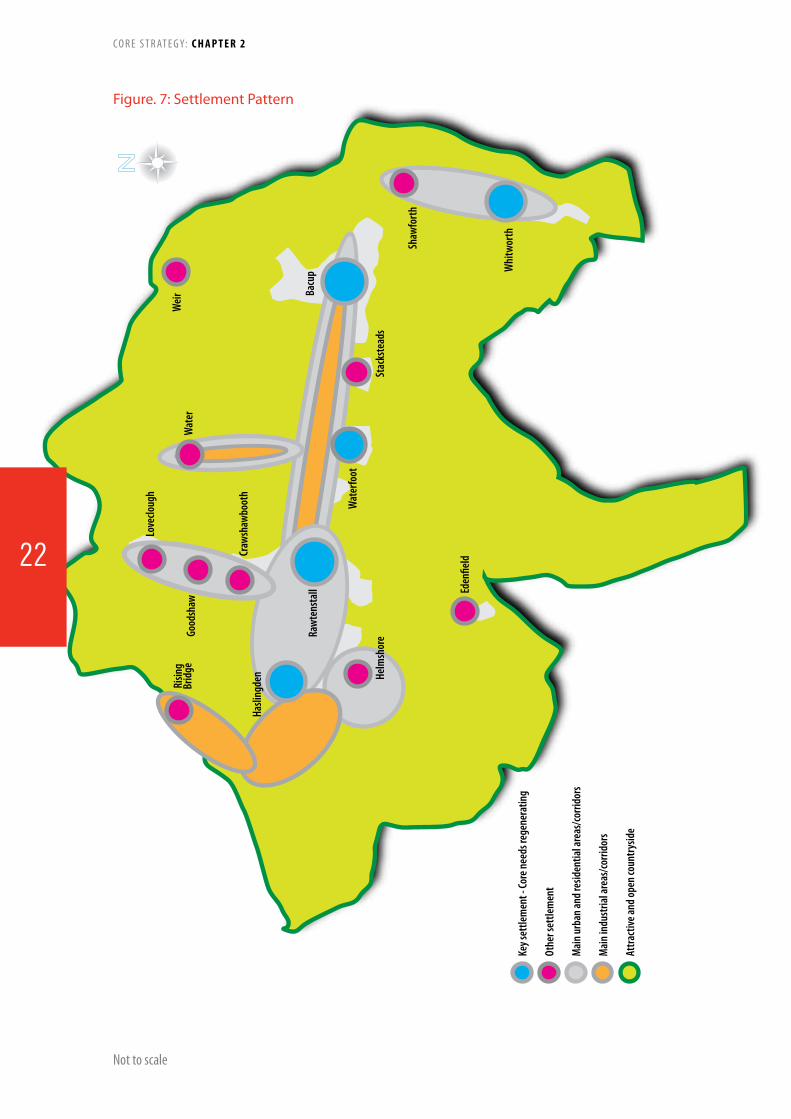
Figure. 7: Settlement Pattern
Not to scale
C O R E S T R AT E G Y: C H A P T E R 2
22
Good
shaw
Gran
e Roa
d
A56
Accr
ingt
on
Burn
ley
Man
ches
ter
Bury
Roch
dale
Todm
orde
n
M66
Risin
gBr
idge
Love
cloug
h
Wat
er
Raw
tens
tall
Wat
erfo
ot
Bacu
p
Whi
twor
th
Loca
l roa
ds m
ostly
30m
ph th
roug
h bu
ilt u
p ar
eas.
Natio
nal m
otor
way
net
wor
k 70m
ph
conn
ectin
g Bo
roug
h to
tow
ns, c
ities
, jo
bs, l
eisu
re an
d en
tert
ainm
ent
Sett
lem
ents
clus
tere
d ar
ound
goo
d tra
nspo
rt
node
s and
com
mun
icatio
n lin
ks
Fast
er lo
cal r
oads
thro
ugh
coun
trys
ide
Hasli
ngde
n
Stac
kste
ads
Wei
r
Shaw
fort
h
Eden
field
Helm
shor
e
Craw
shaw
boot
h
Blac
kbur
n
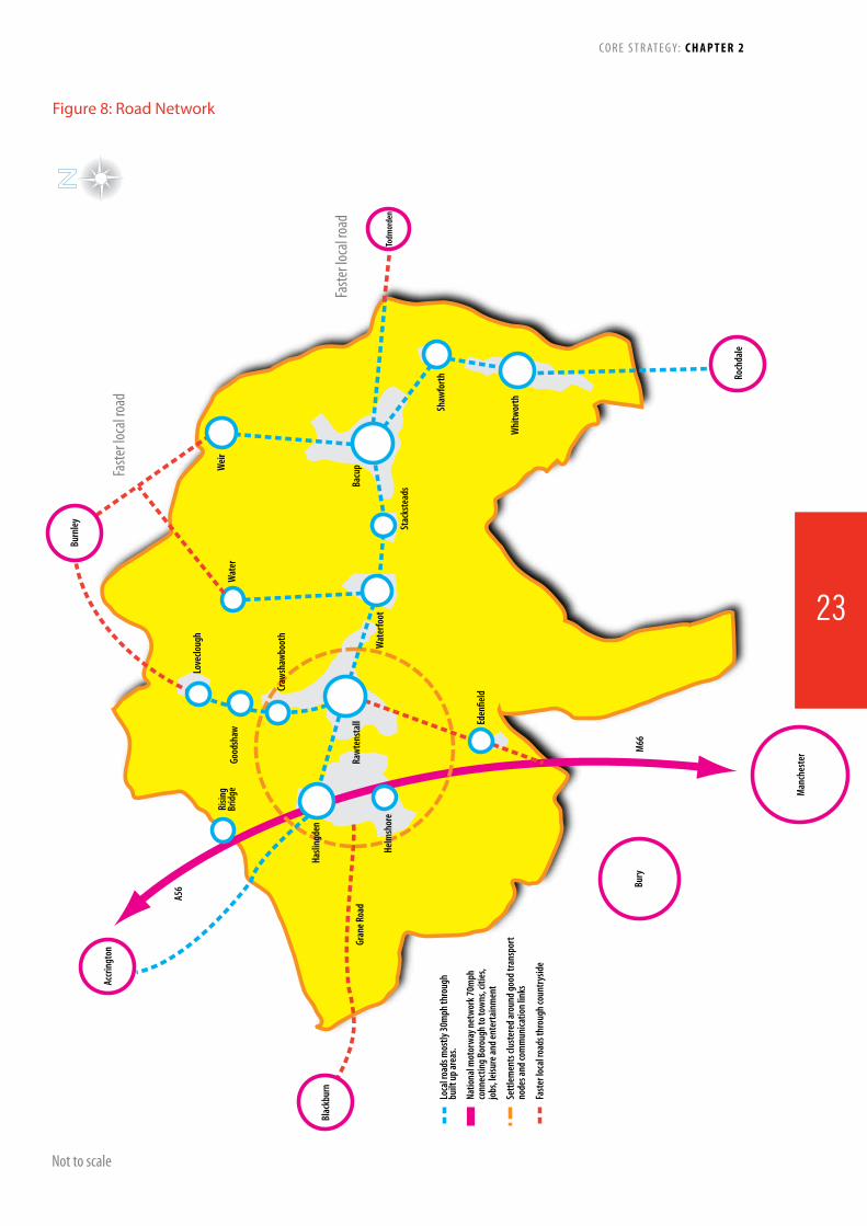
Figure 8: Road Network
Not to scale
C O R E S T R AT E G Y: C H A P T E R 2
Faste
r loc
al ro
ad
Faste
r loc
al ro
ad
23
county figures for the first time in ten years. The rate has since declined. However, the ILO unemployment rate, which includes those seeking work but not claiming benefits, at 4.8 % is below national (5.3%) and the north west figures (5.9%).
82. Overall the Borough’s labour force has more highly skilled occupations and fewer lower skilled manual jobs than the North West averages. For example residents in managerial, professional and associate professional occupations account for 46% of workers compared to 40% in the North west and 43% nationally. The relatively highly skilled nature of residents’ occupations contrasts with the low skills levels of Rossendale’s workforce.
83. The proportion of residents with higher-level qualifications is relatively low (22.3% of working age residents have a degree compared with the regional average of 25.4% and the national figure of 28.6%). The proportion of residents with no qualifications at 12.3% is significantly lower than the average for the North West (at 15%). Although the average wage levels of working residents in the Borough compare with county and regional averages (all being about 5% below the national average), work place levels are much lower (24% below the regional figure and 24% lower than the national figure).
84. These reflect the types of jobs most common within the Borough as being generally lower paid. It also suggests that many residents are commuting out to better paid jobs (particularly in Manchester). This is supported by Rossendale’s relatively low self-containment rate, which reflects the proportion of working age residents in work locally, rather than commuting elsewhere. Rossendale has the largest gap between wages of residents and employees within Lancashire, pointing to significant disparities within the Borough. For example the annual household income of residents in Eden ward is more than £40,000 compared to Stacksteads, where it is £26,000. The UK average is £35,000.
Built Environment and Housing Market
85. Rossendale is characterised by its stone-built terraced housing, most of which was constructed before 1919 which forms a third of the housing stock in the Borough. Partly as a result of the abundance of this type of housing stock, Rossendale has suffered from housing market failure, particularly in the east of the Borough. To tackle the problems of housing market decline, low demand and abandonment, Rossendale was included in Elevate East Lancashire (Regenerate Pennine Lancashire from November 2009), one of the Government’s nine housing market renewal pathfinders. Bacup, Britannia and Stacksteads have been incorporated into this programme, which aims to improve the quality and diversity of the housing stock, along with improving economic prosperity, the environment and community life within these areas. Unfitness is a major problem with 9.1% of the stock falling into this category compared to just 2.4% nationally. Many properties are poorly insulated which contributes to significant amounts of fuel poverty and high domestic CO2 emissions. A
recent stock condition survey concluded that £60 million worth of investment is required across Rossendale’s private sector housing to bring the current housing stock in line with the decent homes standards.
86. Although demand for housing has been high in parts of Rossendale, average property prices in the Borough remain amongthelowestintheregion.Despitehavingrelativelylowhouse prices when compared to regional and national averages, affordability is a major issue for many wanting to access the housing market. This is further aggravated by a local low-wage economy, resulting in an acute affordable housing need throughout Rossendale. The ratio of median house prices to median earnings in 2008 was 6.53 compared to a Lancashire figure of 5.49.
Accessibility
87. The railway link between Rawtenstall and Bury is no longer in general use, although it provides a very successful part-time tourist-orientated steam train service operated by East Lancashire Railway, attracting over 100,000 visitors per year. There are aspirations to open up this line as part of a Manchester to Rawtenstall Commuter Rail Link.
87. Communications in the east-west directions of Rossendale are not as good as those in the west, with only one main road (A681 – A671) that traverses the breadth of the Borough. This is almost entirely lined with urban development and limited to 30mph. It is from this primary road that many of the secondary roads are fed, predominantly towards the north of the Borough along the naturally occurring valleys. Peak hour congestion problems are significant around the gyratory and Burnley Road, Rawtenstall , and in Haslingden and Stacksteads. It is therefore not unexpected that car reliance in Rossendale is high, with 45% of households owning a car or van and 25% having access to two cars or vans. Nevertheless in some wards notably around Stacksteads and Bacup, over 40% of households do not own a car and many services are concentrated in the west of the Valley. Thus the promotion of alternatives to the car and location of facilities such as GP’s, shops and schools will remain a key issue.
89. While Rossendale has highly urbanised valleys the upland area has very little built development though it has been extensively quarried and mined. This and the densest public rights of way network in Lancashire offer a major resource for local walkers and activity based leisure. However, as well as being the largest network in Lancashire it is one of the worst maintained and some of the quarries present significant safety risks. The Rossendale area contains surface coal resources and has previously been subjected to coal mining activities which will have left an environmental legacy. This legacy has the potential to lead to public safety hazards unless there is awareness and any risks have been fully considered and appropriate treatment/mitigation measures have been incorporated within new developments.
C O R E S T R AT E G Y: C H A P T E R 2
24

Key Issues
Regeneration
90.Derelictandvacantlandandbuildingsisakeychallengefor Rossendale with 122.33 ha of previously developed land identified in 2008. While this is a resource for positive re-use, many of the sites are located in prominent locations in or adjacent to town centres and are deterring investment and halting regeneration.
91. The town centres in the Borough are in significant need of enhancement. The Valley Centre in Rawtenstall requires either replacement or refurbishment as it undermines the attractiveness of the whole centre. Bringing forward an acceptable scheme has been hampered by the recession. The New Hall Hey area has a part -implemented retail/office permission and together with the railway station is poorly related into the town centre. A new bus station with modern facilities and integrated into the towncentreisrequired.DowntheValleyinBacupthecentrehasbeen unable to attract significant national retailers as the major
superstores are all clustered in and around Rawtenstall. It has many vacant and under-used buildings, a number of which are listed as being of historic value but will be costly to repair. It has significant potential however to be a very attractive place to visit and live. In addition, English Heritage is supporting regeneration initiatives in the town. Haslingden would benefit from upgrading and enhancing streets and pavements, a reduction in the number of vacant shop units and a limit on the number of hot food takeaways. The markets increase diversity within Rawtenstall, Haslingden and Bacup each face challenges to their viability as do many small shops, both within centres and outside them. However, throughout the Borough, are several retail outlets which attract shoppers from outside the Borough.
92. Indoor leisure facilities within the Borough are concentrated at Haslingden Leisure Centre and Haslingden Pool, Marl Pits at Rawtenstall, Whitworth Leisure Centre and Bacup Leisure Hall. Secondary School facilities are available for public use in evenings
Regeneration• CurrentpoorconditionofValleyCentreandNew
Hall Hey in Rawtenstall• RegenerationofBacuptowncentrewhilst
respecting its historic character• VacanciesandpublicrealminHaslingdenTown
Centre • Reducingvacantandderelictlandandbuildings• MeetidentifiedlocalhousingneedsConnectivity• PotentialofEastLancashireRailwayascommuter
link to Manchester• Addressingtheeast-westsplitwithinRossendale• Howtoenhancethetouristpotentialof
Rossendale including walking/cycling access and outdoor leisure
• EnhanceRawtenstalltowncentreincludingprovisionofanewbusstationandwalkinglinksfromthestation/NewHallHey
• Localtrafficcongestione.g.gyratoryinRawtenstall
• Improveaccesstoservicesandemploymentespeciallyfromtheeastofthearea
Environment• Givingdueconsiderationtothepresenceof
surfacecoalresourcesandaddressingissuesrelatingtoformercoalminingactivities
• Reduceimpactofclimatechangeincludinghighlocal per capita CO2 production
• Protecting,enhancing,extending,linkingand improving access to the Borough’s valued nature conservation resources so as to improve biodiversity and enable species to adapt to the impactsofclimatechange.
• Ensuringthatthecharacterandqualityofthe Borough’s landscapes are conserved and enhanced.
• ConservationandenhancementoftheBorough’sgeologicalassets,geodiversityandRegionallyImportantGeologicalandGeomorphologicalSites(RIGS).
• Safeguardingtheextentandopennessofthedesignated Green Belt
Design• Promotesustainabledesignandreinforcelocal
distinctiveness• Accommodatingdevelopmentinawaythat
respectsthecharacterofthearea• ConserveandimprovethebuiltheritageEconomic Growth and Tackling Deprivation• RetainKeyAgeGroups(20-24)• Manageandexpandthelocalruraleconomy• Improvehealthandwellbeingespeciallyinthe
most deprived wards• Increaseeducationalattainmentandimprove
local skills• Meetlocalemploymentandbusinessneeds• Lackofovernightaccommodationforvisitors
C O R E S T R AT E G Y: C H A P T E R 2
25

CHaPtErrossendale in 2026
spatial Vision and strategic
objectives3Rossendale in 202693. This chapter is the starting point for the rest of the Core Strategy and sets out a vision of what Rossendale will be like in 2026 after this plan has been successfully implemented.
94. From this vision, 8 objectives are proposed which cover the main issues for Rossendale and set out how the planning process for the next 15 years will address, improve and deliver them.
95. The 8 Strategic Objectives are Borough-wide and include the following:
Public transport improvements
Meeting housing needs
Improve access to education, skills, training, health and job opportunities
Enhance and protect our built heritage
Supporting and encouraging local businesses and new sectors of the economy
Improve and promote Rawtenstall as the main town centre, supported by Bacup, Haslingden and other local centres
Enhance and protect out natural environment
Reduce the impact of climate change
96. This chapter also sets out the key projects that will help transform Rossendale into a place where people want to live, work and visit. The Transformational Projects include:
The Adrenaline Gateway
Bacup Town Centre Renaissance and Regeneration
The Rossendale Health Campus
Manchester to Rawtenstall Commuter Rail Link
Haslingden Renaissance Plan
Rawtenstall Town Centre Regeneration
Bacup 14-21 Vocational Education Campus
97. All policies and plans from this point on must help to achieve these objectives and the overall vision for Rossendale.
26

27

Spatial VisionRossendale is defined by its Pennine moorland countryside and small stone built towns and villages located along the valley floors and will continue to be so.
By 2026, we aim to reduce inequalities across the Borough by strengthening opportunities in the east of Rossendale and fulfilling the potential of the west of the Borough.
Rawtenstall and its surrounding communities will be the central focus of the Borough. The Valley Centre will be redeveloped and will act as a regeneration catalyst for the rest of the town centre, incorporating additional and increased choice of shopping and office facilities, well linked to a new bus interchange and Rawtenstall train station.
Rossendale’s distinctive landscapes and natural assets will continue to be protected and enhanced for both their intrinsic value to biodiversity and their recreational and economic value to local people and tourists alike.
The east of Rossendale including Bacup, Stacksteads, Britannia and Whitworth will continue to develop as tourist destinations for sport and recreational activities as well as an area of historical and architectural interest.
Most development including housing and affordable housing will take place within the urban boundaries of the main settlements, capitalising on the move towards a low-carbon economy and supporting sustainable lifestyles. Particular emphasis will be placed on realising the objectives of the existing Housing Market Renewal programme and any subsequent initiatives in the east.
Rawtenstall together with Haslingden, Bacup and Whitworth will remain priority areas for economic development including employment and office space.
C O R E S T R AT E G Y: C H A P T E R 3
28

SCS Objective14
SCS Objectives7, 8, 10 & 14
SCS Objectives7, 10 & 12
SCS Objectives1, 2, 11 & 13
SCS Objectives9 & 10
SCS Objective9
SCS Objectives4, 6 & 8
SCS Objectives12 & 13
SO1: To improve public transport links to and from Greater
Manchester.
SO6: Promote Rawtenstall as the
main town centre for Rossendale.
SO2: Meet the housing needs of the
current and future population(s).
SO5: Encourage and support
local businesses, entrepreneurs and new sectors of the economy
to grow.
SO3: Create the opportunities for
people to acheive their aspirations.
SO8:To mitigate and adapt to climate
change.
SO4: To enhance and improve Rossendale’s
new and existing built environment.
SO7: Enhance and protect Rossendale’s natural environment
and landscapes.
Policies: 1, 7, 8, 9, 21 & 22 Area Visions: 1-4
Policies: 1, 9, 10-13, 21, 22, Area Visions: 2-4, 6
Policies: 1-5, 19, 21 - 23 Area Visions: 1-6
Policies: 1, 6, 7, 10, 14, 15, 21, 22, Area Visions: 2, 4 & 6
Policies: 1, 10, 16, 17, 21 - 24 Area Visions: 2, 3, 5 & 6
Policies: 1, 2, 7-10, 13, 14 - 24Area Vision: 2
Policies: 1, 10, 16, 17, 19, 21 - 24 Area Visions: 2, 3, 5 & 6
Policies: 1, 8, 9, 10, 14 - 24Area Visions: 2-6
Sustainable Community Strategy (SCS) Objectives
1. More people to enjoy better health and mental well-being.
2. Increased life expectancy.3. More physically active
people.4. Keep young people in the
Borough.5. Safer communities and
places.6. Communities that get on
well together.7. Reduce carbon footprint
and environmental impact.8. Decent and affordable
homes.9. Clean and attractive town
centres.10. More people visiting
Rossendale.11. Increase educational
attainment and vocational qualifications.
12. Thriving economy and growing business service sector.
13. Everyone to benefit from Rossendale’s prosperity.
14. Improved transport and less dependence on the car.
Key issues
• ConditionofValleyCentreandNew Hall Hey
• DeclineofBacupTownCentre• Lackofcommuterraillink• East-Westdivide• Healthandmentalwell-being
inequalities• Amountofvacantandderelict
land and buildings• Localtrafficcongestion• Accesstoservicesand
employment opportunities• Conditionandvarietyofexistinghousingstock
• Significantlevelsofoutcommuting
• Lossof20-24yearolds• Lowerthanaveragelevelsof
educational attainment• Acutedeprivation• HighlevelsofCO2emissions
per capita• Maintainingandimproving
the built environment
AreaVisions
AreaVisions:1.Whitworth,Facit&Shawforth2.Bacup,Stacksteads&Weir3.Waterfoot,Lumb,Cowpe&Water4.Rawtenstall,Crawshawbooth,Goodshaw&Loveclough5.SouthWestRossendale6.Haslingden&RisingBridge
Policies
1.GeneralDevelopmentLocationsandPrinciples2.AmountofHousing3.DistributionofHousing4.Affordable&SupportedHousing5.GypsyandTravellers6.TrainingandSkills7.SocialInfrastructure8.Transport9.Accessibility10.Employ-mentLand11.Retail&TownCentreUses12.TheValleyCentre13.ProtectingLocalRetail14.Tourism15.VisitorAccommodation16.TheBuiltEnvironment17.GreenInfrastructure18.Biodiversity,GeodiversityandLandscapeConservation19.ClimateChange&RenewableEnergy20.WindEnergy21.TheRuralEconomyandCommunities22.PlanningContributions23.PromotingHighQualityDesignandSpaces24.PlanningApplicationRequirements
COMPOnEnTSOFTHECORESTRATEGyAnDRELATIOnSHIPSWITHTHESUSTAInABLECOMMUnITySTRATEGyAnDKEyISSUES
33A
VI SIO
NVISIO
N

KEY DIAGRAM
Britannia
RiverSpodden
RiverIrwell
Cribden Hill
GoodshawRisingBridge
Crawshawbooth
Loveclough
MaryTowneley
Loop
A682to Burnley
B6323to Burnley
A671to Burnley
WaterDean
Rawtenstall
Waterfoot
Bacup
Whitworth
Haslingden
DeerplayMoor
Weir
Lumb
WhitewellBottom
StacksteadsLee Quarry
A681to Todmorden
and West Yorkshire
Shawforth
Facit
MaryTowneley
Loop
Cowpe
A681
Scout Moor
A6066to Rochdale
DeardenMoor
A680to Accrington
Holden Wood Reservoir
Cowpe Reservoir
Cowm Reservoir
Healey DellLocal Nature
Reserve
ClowbridgeReservoir
Ogden ReservoirCalf Hey
Reservoir
A6177to Blackburn Grane
A56
MusburyTor
Turn
Eden�eld
StubbinsM66
to Bury& Manchester
Helmshore
IrwellVale
A680to Rochdale
P
Bury
Manchester
Blackburn with Darwen
Hyndburn Calderdale
Burnley
Rochdale
Housing
Retail & Shopping
Tourism
Valley Centre
Employment
O�ce
Halo Panopticon
Mountain BikingFacility
Countryside
Built Up Areas
Parking
Train Station
Bus Station
Training &Skills
Park &Ride
GreenBelt
Rawtenstall - Manchester rail link
External in�uences/pressures
Heritage &Conservation
P
31B Not to scale

C O R E S T R AT E G Y: C H A P T E R 3
29

Transformational Projects
98. The six projects identified in Rossendale’s Sustainable Community Strategy 2008-2018 which will assist in the transformation of the Borough over the next 5 to 10 years will also aid in delivering the Strategic Objectives outlined on pages 31.
The six transformational projects identified in the Sustainable Community Strategy include:
Project How will it be delivered? When will it be delivered?
The Adrenaline Gateway – delivering a unique leisure and cultural experience by making a wide range of adrenaline sports activities accessible to people from across the North West.
Through the identification of suitable locations and sites to support adrenaline sports, particularly mountain biking throughout Rossendale and actively support suitable schemes and proposals and where necessary assist with gap funding through the regeneration process.
The Adrenaline Gateway is not a project, but a concept that will be delivered and improved upon throughout the life of the Core Strategy.
The success of Lee Quarry is already evident and it is anticipated that this will continue to grow and develop in the years to come.
Bacup Town Centre Regeneration and Renaissance – to stimulate economic activity in Bacup town centre by attracting new and growing businesses to the area.
Through the preparation of a Conservation Area Appraisal and Management Plan and bidding for funding to attract investment in bringing back into use and renovating historically important commercial buildings in the Conservation Area.
By developing and implementing planning policies which will attract new and different businesses to the town and give the area a unique role and identity.
Work on the Conservation Area Appraisal is nearing completion and funding from English Heritage has been secured to assist and undertake conservation work, including the preparation of a Management Plan.
It is anticipated that the first stages of the Bacup Town Centre Regeneration and Renaissance work will be completed within the first 5 years of this plan.
The Rossendale Health Campus The Health Campus in Rawtenstall is completed and was funded by the East Lancashire Primary Care Trust.
Manchester to Rawtenstall Commuter Rail Link – will aim to provide a frequent and regular railway connection between Pennine Lancashire and Greater Manchester.
JointworkingandpartnershipwiththeEastLancashire Railway Trust, Rossendale Borough Council, Transport for Greater Manchester (TIGM), Lancashire County Council, neighbouring authorities and Network Rail will be required to help deliver this project, funding opportunities are being explored.
This is a long term goal for Rossendale as it is acknowledged that delivery is complex. However, it is anticipated that the railway will be re-opened to commuter journeys toward the end of the life of this Core Strategy.
C O R E S T R AT E G Y: C H A P T E R 3
30

Project How will it be delivered? When will it be delivered?
Haslingden Renaissance Plan – to identify key areas for improvement in Haslingden town centre.
Through the re-definition of the town centre, a new Conservation Area and an Area Vision and policy which will guide new development to the town, improving key areas in the process.
Improvements will be made through focused regeneration efforts and schemes.
The renaissance of Haslingden is a long term goal and will be an ongoing project throughout the life of this Core Strategy.
Rawtenstall Town Centre Regeneration – planned regeneration including redevelopment of the Valley Centre, the creation of a retail, leisure and business park on New Hall Hey and a hotel on the former college site.
Through the identification of the Valley Centre redevelopment as a Council priority and partnership working with committed developers to deliver the right type of development on the site.The same is true for New Hall Hey and the former college site and the Council is committed to working with the landowners and prospective developers to achieve the best results for the sites and Rossendale.
The Regeneration of Rawtenstall and in particular the redevelopment of the Valley Centre should be deliverable within the first half of the plan.
Additional transformational projects identified through the LDf process
Bacup14-21VocationalEducationCampus
Partnership working between Accrington and Rossendale College, Lancashire County Council,localsecondaryschools,LCDLandgrant funding bodies.
The education campus in Bacup should deliverable within the first half of the plan.
99. These projects will be delivered through the planning and regeneration processes and will act as catalysts for future growth and development in Rossendale.
31
C O R E S T R AT E G Y: C H A P T E R 3
31

CHaPtEr 4area Visions and Policies
Rossendale in 2026100. An Area Vision is a broad plan for a part of Rossendale and aims to provide some direction for the future of local areas for local people, developers, investors and the Council.
101. The six Area Visions cover the following broad areas:
Whitworth, Facit and Shawforth
Bacup, Stacksteads, Britannia and Weir
Waterfoot, Cowpe, Water and Lumb
Rawtenstall, Crawshawbooth, Goodshaw and Loveclough
Haslingden and Rising Bridge
South West Rossendale: Helmshore, Edenfield, Stubbins, Irwell Vale and Lumb and Ewood Bridge
102. The Area Visions outline the strengths, weaknesses, opportunities and threats of each area, and then propose a way forward to address the key issues and make the best use of any opportunities, whilst meeting all the necessary needs and demands.
103. Each Area Vision and Policy is accompanied by a map, illustrating where and how the policy and vision could be achieved.
104. The maps identify broad areas of potential development and protection and have been informed by a series of assessments and studies. A minimum of three options were consulted on for each Area Vision and the proposals put forward reflect the responses received to these.
105. The maps do not seek to allocate land for specific uses or signal that planning applications would be approved for the types of development indicated.
106. The Area Visions and Policies should not be read in isolation. They act as a guide for future development in the area, but proposals and allocations will be determined in line with the other policies in the Core Strategy.
32

33

34
107. The Area Visions and Policies are aimed at addressing local issues and problems and maximising local strengths and opportunities. In doing so, the Area Visions and Policies provide a level of certainty about the future of the areas and set out the principles for future development and improvements within Rossendale’sLDF.
108. The overall vision for Rossendale and the strategic objectives to achieve this (page 31A) are aimed at tackling borough-wide issues. However, there are certain areas within Rossendale where some of the key issues identified (page 27) are more relevant or significant. Hence to make the Core Strategy as effective as possible at addressing the key issues and achieving the Vision and Strategic Objectives across the Borough, Area Visions have been created to give local areas the attention and direction they need, to address their own individual problems and make the most of their strengths and opportunities.
109.BetweenJanuaryandAugust2009,Rossendalewassplit
into eight areas, influenced by housing market area boundaries, existing Area Action Plan (AAPs) boundaries as well as reflecting Rossendale’s fierce local identities which are upheld by local residentsandcommunities.Duringtheconsultationprocess,149 representations were received and it was suggested that a consistent approach to the Area Vision boundaries was required. In addition it was felt that too much emphasis was placed upon Rawtenstall and Bacup as a result of the existing AAP boundaries and other settlements were not given the degree of attention required.
110. It was decided that to better link the areas together and reflect the reality of communities within Rossendale, each Vision and Policy should reflect the housing market boundaries and properly illustrate the relationships between communities and neighbouring areas and settlements.
111. Subsequently the Area Visions for Rawtenstall and Crawshawbooth, Loveclough and Goodshaw have been combined
C O R E S T R AT E G Y: CHAPTER 4
34

to form one Area Vision and Policy and the Area Visions for Bacup and Stacksteads, Britannia and Weir have been combined to form one Area Vision and Policy, resulting in a reduction from 8 to 6 Area Visions and Policies.
112. The Area Visions and Policies should not be read in isolation. The principles for all future development are set out in the Topic Planning Policies in Chapter 5 and will apply to every planning application, proposal and allocation that will come forward between now and 2026.
113. It is important to understand that the Area Visions and Policies do not override or take precedence over the Topic Planning Policies, but act to guide and steer development in local areas and communities, reflecting their distinctive characteristics.
C O R E S T R AT E G Y: CHAPTER 4
35
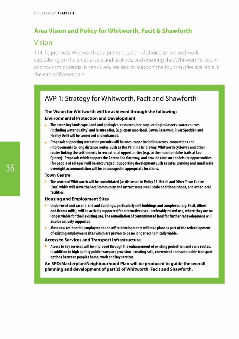
Vision114. to promote whitworth as a prime location of choice to live and work, capitalising on the area’s assets and facilities, and ensuring that whitworth’s leisure and tourism potential is sensitively realised to support the tourism offer available in the east of rossendale.
Area Vision and Policy for Whitworth, Facit & Shawforth
AVP 1: Strategy for Whitworth, Facit and Shawforth
The Vision for Whitworth will be achieved through the following:Environmental Protection and Development Thearea’skeylandscape,landandgeologicalresources,heritage,ecologicalassets,watercourses(includingwaterquality)andleisureoffer,(e.g.openmoorland,CowmReservoir,RiverSpoddenandHealeyDell)willbeconservedandenhanced.
Proposalssupportingrecreationpursuitswillbeencouragedincludingaccess,connectionsandimprovementstolongdistanceroutes,suchasthePennineBridleway,Whitworthcyclewayandotherrouteslinkingthesettlementstorecreationalopportunities(e.g.tothemountainbiketrailsatLeeQuarry).ProposalswhichsupporttheAdrenalineGateway,andprovidetourismandleisureopportunities(forpeopleofallages)willbeencouraged.Supportingdevelopmentsuchascafes,parkingandsmallscaleovernightaccommodationwillbeencouragedinappropriatelocations.
Town Centre ThecentreofWhitworthwillbeconsolidated(asdiscussedinPolicy11:RetailandOtherTownCentreUses)whichwillservethelocalcommunityandattractsomesmallscaleadditionalshops,andotherlocalfacilities.
Housing and Employment Sites Under-usedandvacantlandandbuildings,particularlymillbuildingsandcomplexes(e.g.Facit,AlbertandOramamills),willbeactivelysupportedforalternativeuses-preferablymixed-use,wheretheyarenolongerviablefortheirexistinguse.Theremediationofcontaminatedlandforfurtherredevelopmentwillalsobeactivelysupported.
Mostnewresidential,employmentandofficedevelopmentswilltakeplaceaspartoftheredevelopmentofexistingemploymentsiteswhichareproventobenolongereconomicallyviable.
Access to Services and Transport Infrastructure Accesstokeyserviceswillbeimprovedthroughtheenhancementofexistingpedestrianandcycleroutes,inadditiontohighqualitypublictransportprovision-creatingsafe,convenientandsustainabletransportoptionsbetweenpeopleshome,workandkeyservices.
An SPD/Masterplan/Neighbourhood Plan will be produced to guide the overall planning and development of part(s) of Whitworth, Facit and Shawforth.
C O R E S T R AT E G Y: CHAPTER 4
36

Background
115. The area known as Whitworth covers the entire length of the Whitworth Valley, an area of about seven square miles, with a population of about 7,500 people. It lies in the foothills of the South Pennines, lying between Bacup and Rochdale. It is a long, thin settlement, surrounded by countryside, some of which is designated as Green Belt. It is made up of the communities of Healey, Whitworth, Facit and Shawforth, all of which are linked by the A671.
116. The River Spodden rises near the village of Shawforth, and flows through Whitworth until its confluence with the River Roch, south of Rochdale. Although the river flows through the urban areas of Shawforth, Whitworth and Wallbank, the wider area drained by the River Spodden is predominantly rural in nature.
117. The twentieth century saw improvements in the living conditions of Whitworth’s population and in the amenities provided. Cramped terraces, which had been built quickly and densely to house the influx of workers in the cotton mills, have been replaced, modernised or renovated in both the public and private sector. Civic buildings have been erected and parks and open spaces provided. In April 1976, an area in and surrounding HealeyDellatthesouthendoftheValleybecamelegallydesignated as a statutory Local Nature Reserve, the only one in Rossendale.
Strengths, Opportunities and Key Issues
Issues Strengths and Opportunities
Developmentconstrainedby surrounding topography and much of the countryside is designated as Green Belt.
The town is socially mixed, though this masks some significant deprivation issues (e.g. above average uptake of free school meals.)
Former mills are becoming unsuitable for modern manufacturing and are falling vacant and into disrepair, under pressure to be developed for non-employment uses.
Although the community spirit is strong, the town does not have a real centre, with key facilities spread out along its length including several small shopping parades, Several informal comments have been made about creating a heart for the town. The retail offer is relatively good with independent shops as well as limited national operators.
Residents have access to a range of key services. (E.g. four primary schools, a secondary school, medical centre, hospital, swimming pool, library and a newly built community centre).
Leisure opportunities are available with good accesstothecountryside;Cowm Reservoir regularly hosts competitions for water related sports.
The settlement is served by a Quality Bus Corridor (the 464 bus), which links Rochdale to Accrington via the Borough’s other key settlements of Bacup, Waterfoot, Rawtenstall and Haslingden. However, the main road is a single carriageway so improvements are limited.
There is a good mix of housing, and the town has several buildings of historical and architectural interest and contains a Conservation Area.
C O R E S T R AT E G Y: CHAPTER 4
37
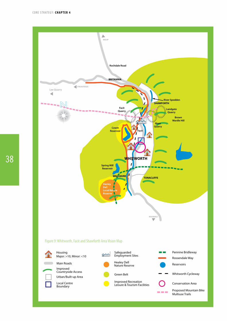
EDGESIDE
STACKSTEADSBACUP
WHITWORTH
MANCHESTER
STACKSTEADS
BACUP
ROCHDALE
SHAWFORTH
BRITANNIA
WALLBANKTONACLIFFE
WHITWORTH
CowmReservoir
BrownWardle Hill
Lee Quarry
Facit
Spring MillReservoir
River Spodden
Rochdale Road
LandgateQuarry
Healey DellLocal Nature Reserve
MossQuarry
FacitQuarry
Main Roads
Improved Countryside Access
SafeguardedEmployment Sites
Green Belt
Pennine Bridleway
Reservoirs
Whitworth Cycleway
Local CentreBoundary
Rossendale Way
Improved RecreationLeisure & Tourism Facilities
Urban/Built-up Area
Healey DellNature Reserve
HousingMajor: >10, Minor: <10
Conservation Area
Proposed Mountain Bike/Multiuse Trails
Figure 9: Whitworth, Facit and Shawforth Area Vision Map
C O R E S T R AT E G Y: CHAPTER 4
38

Policy Target Trigger Indicator Contingencies
AVP1 Creation of multi-user bridleway linking Facit Quarry to Lee Quarry by April 2012
Funding not confirmed by April 2011Contractor not in placebyJune2011Work completed by April 2012
DiscussionswithLCDLre. fundingProgress update with LCDL/LCC
Identify the problem and barriers/causes to development via discussions and/or assessment(s)Identify alternative sources of fundingDiscusssolutionstootheridentifiedconstraintswhich are delaying progress with various stakeholders e.g. land owners, LCC etc.
AVP1 Extension of multi-user bridleway from Whitworth to Rochdale by 2016
Funding not confirmed by April 2014Contractor not in placebyJune2014Work completed April 2016
DiscussionswithLCDLre. fundingProgress update with LCDL/LCC
Identify the problem and barriers/causes to development via discussions and/or assessment(s)Identify alternative sources of fundingDiscusssolutionstootheridentifiedconstraintswhich are delaying progress with various stakeholders e.g. land owners, contractor, LCC etc.
118. The maps identify broad areas of potential development and protection and have been informed by a series of assessments and studies. The maps do not seek to allocate land for specific uses or signal that planning applications would be approved for the types of development indicated.
119. The Area Visions and Policies should not be read in isolation, they act as a guide for future development in the area, but proposals and allocations will be determined in line with the other policies in the Core Strategy.
Monitoring and Implementation
C O R E S T R AT E G Y: CHAPTER 4
39

Vision120. Bacup will be the hub of the Valley’s emerging tourism industry, building on its rich built and natural heritage supported by complementary developments and opportunities within stacksteads, Britannia and weir. the area’s distinct sense of place is to be retained and enhanced, with vacant sites and buildings to be occupied and open spaces retained. Local people will have a variety of employment and residential opportunities to choose from, supported by appropriate training and educational facilities.
Area Vision for Bacup, Stacksteads, Britannia & Weir
AVP 2: Strategy for Bacup, Stacksteads, Britannia and WeirWithin Bacup, Stacksteads, Britannia and Weir it is proposed that:
Heritage and Sense of Place The distinct local heritage and sense of place of the area will be conserved and enhanced, particularly through
regeneration initiatives. further policies for this area will be developed through the Local Development framework. This will build on the
area’s distinct sense of place, available regeneration opportunities, and promote Bacup’s vitality and viability. It will also seek to strengthen links within the town and to nearby settlements and key attractions and the open countryside.
Lee Quarry is designated as a Site of Special Scientific Interest and the Council will seek to ensure the conservation and enhancement of the special features of this SSSI.
Housing Limited residential development on infill sites in Weir and Britannia will be supported where they contribute to
the aims of the HMR area or any future programmes. Larger housing schemes will be accommodated in Stacksteads and Bacup where they contribute to the aims of
the HMR area or any future programmes.Access
Pedestrian and cycle connections throughout the area and to visitor attractions such as the Adrenaline Gateway, Lee Quarry, the Irwell Sculpture Trail and the wider countryside will be improved and enhanced (particularly along the old railway lines). Cycle links between Lee Quarry and Bacup Town Centre will also be developed to encourage cyclists to visit the town centre.
Improvements to public transport provision and accessibility to and from the area will be prioritised. Town centre parking in Bacup and at key visitor locations will be provided and improved.
Employment, Retail and Tourism Proposals for tourism and leisure related developments as well as farm diversification which generate local
employment opportunities will be considered favourably. Retail development which does not affect the vitality and viability of any centre will be supported, where it
would generate local training and / or employment opportunities, and improve the offer for Bacup. Newline and Suttons industrial estates will be safeguarded for employment uses, while futures Park will
be promoted as a location for education and skills development with provision for some small scale office development in combination with facilities supporting the tourism visitor economy.
An SPD/Masterplan/Neighbourhood Plan will be produced to guide the overall planning and development of part(s) of Bacup, Stacksteads, Britannia and Weir.
C O R E S T R AT E G Y: CHAPTER 4
40

Background
121. Bacup, Stacksteads, Britannia and Weir are four distinct communities lying in the east and north east of Rossendale occupying a dramatic landscape setting with a rich natural environment, surrounded by the moorlands of the South Pennines. There is a strong sense of place provided partly by the traditional stone buildings and the small terraces on the valley sides.
122 Lee Quarry is designated as a Site of Special Scientific Interest, noted for its geology. This site is also used as a mountain biking facility, which is an integral part of the Adrenaline Gateway Transformational Project for the Borough. It will be imperative to ensure that the special qualities of this SSSI are not undermined, but are conserved and enhanced through any future developments.
123. The settlements developed and grew primarily because of the cotton industry in the 19th century. Bacup has been described as a ‘remarkable survivor’ given that it remains much as it was at the turn of the 20th century, the boom-time of the Industrial Revolution. It is regarded as one of the best preserved mill towns in the country and English Heritage is supporting the Council’s work in historic preservation and enhancement.
124. Bacup, Stacksteads and Britannia have been included within the Regenerate Pennine Lancashire Housing Market Restructuring Programme, one of the housing pathfinders aimed at bringing about improvements in areas of low housing demand. However, unlike other Pathfinder initiatives, residents successfully ensured that demolition should not be considered as a means of balancing the housing market by reducing the number of terraced houses.
125. Consultation has previously been undertaken on two Area Visions covering the areas. However, given the linkages between these four settlements it has been decided to create one Area Vision for this key area of the Valley.
Strengths, Opportunities and Key Issues
Issues Strengths and Opportunities
Poor public realm with high number of vacant, dilapidated buildings
Anti-social behaviour, poor general health, low skills and educational attainment, high crime, ageing and declining population (18-24 year olds moving away)
Employment market focused on traditional manufacturing sector
Housing market failure with generally low house prices and dominance of terraced housing
Perception of isolation – ‘at the end of 3 valleys’
Difficulttodeliversitesdue to constraints – contamination etc
Limited opportunities for private sector investment
Distinctsenseofplaceandheritage value
Good access to countryside with potential for tourism and outdoor leisure opportunities (e.g. mountain bike trails, bridleways, hill walking)
Close to employment opportunities in Rochdale and Burnley
Quality Bus Corridor linking to Accrington and Rochdale but poor access to Manchester City Centre
Renewable energy potential (wind, hydroelectric etc)
Proximity to and attraction of the Adrenaline Gateway project and Lee Quarry SSSI
Cultural facilities, such as, The Royal Court Theatre
C O R E S T R AT E G Y: CHAPTER 4
41
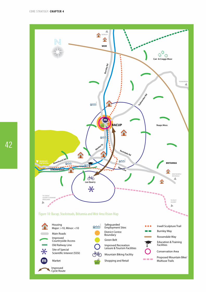
BRITANNIA
WEIR
STACKSTEADS
BACUP
Newchurch Rd
Market St
Todm
orden
Rd
Rochdale Rd
New Line
Burn
ley
Rd
TODMORDEN
BURNLEY
TO CRAGG QUARRY & PENNINEBRIDLEWAY
WHITWORTH /ROCHDALE
WATERFOOT /RAWTENSTALL
TO FACIT QUARRY
Carr & Craggs Moor
Reaps Moss
Lee Quarry
m
Main Roads
Old Railway Line
Improved Countryside Access
SafeguardedEmployment Sites
Green Belt
Burnley Way
Education & TrainingFacilities
Rossendale Way
Irwell Sculpture Trail
Improved RecreationLeisure & Tourism Facilities
Mountain Biking Facility
District CentreBoundary
HousingMajor: >10, Minor: <10
Conservation AreaSite of Special Scienti�c Interest (SSSI)
Market Shopping and RetailProposed Mountain Bike/Multiuse Trailsm
ImprovedCycle Route
Figure 10: Bacup, Stacksteads, Britannia and Weir Area Vision Map
C O R E S T R AT E G Y: CHAPTER 4
42
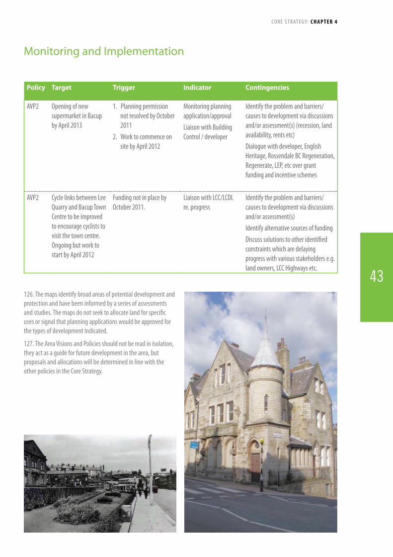
Policy Target Trigger Indicator Contingencies
AVP2 Opening of new supermarket in Bacup by April 2013
1. Planning permission not resolved by October 2011
2. Work to commence on site by April 2012
Monitoring planning application/approval Liaison with Building Control / developer
Identify the problem and barriers/causes to development via discussions and/or assessment(s) (recession, land availability, rents etc)Dialoguewithdeveloper,EnglishHeritage, Rossendale BC Regeneration, Regenerate, LEP, etc over grant funding and incentive schemes
AVP2 Cycle links between Lee Quarry and Bacup Town Centre to be improved to encourage cyclists to visit the town centre. Ongoing but work to start by April 2012
Funding not in place by October 2011.
LiaisonwithLCC/LCDLre. progress
Identify the problem and barriers/causes to development via discussions and/or assessment(s) Identify alternative sources of fundingDiscusssolutionstootheridentifiedconstraints which are delaying progress with various stakeholders e.g. land owners, LCC Highways etc.
126. The maps identify broad areas of potential development and protection and have been informed by a series of assessments and studies. The maps do not seek to allocate land for specific uses or signal that planning applications would be approved for the types of development indicated.
127. The Area Visions and Policies should not be read in isolation, they act as a guide for future development in the area, but proposals and allocations will be determined in line with the other policies in the Core Strategy.
Monitoring and Implementation
C O R E S T R AT E G Y: CHAPTER 4
43

Vision128. waterfoot will have a distinct and vibrant local centre acting as a small retail niche supporting local businesses. the area will support the wider tourism and leisure opportunities and facilities within rossendale with appropriately located facilities and services. this will in turn be supported by improved access to the countryside. the majority of previously-developed sites and buildings will have been developed for functional and sustainable uses, contributing to the atmosphere and community spirit of the area. some additional employment and housing development will act to support the local economy and provide people with a choice of employment and residential opportunities.
Area Vision and Policy for Waterfoot, Cowpe, Lumb and Water
AVP 3: Strategy for Waterfoot, Cowpe, Lumb and WaterTo achieve the vision for Waterfoot, Cowpe, Lumb and Water, the Council will:Town Centre and Regeneration ConsolidateWaterfootpromotingitasalocalcentreforsmallbusinessesandindependentshops,incorporatingpublicspaceprovisionthroughasmallsquareorotherpublicfocalpoint.
Activelyencouragethere-useofderelict/underusedsitesandbuildings(inparticulartheVictoriaArcade)anddevelopastrategytoassemblebrownfieldlandfordevelopment.
Community Facilities and Leisure Provide additional leisure and recreation provision within the smaller settlements combined with promotingactivitiesintheruralcommunitiesandwithinoradjoiningthemainurbanarea,identifysuitablesitesfortourismdevelopmenttosupporttheAdrenalineGateway.
Enablecommunityfacilitiessuchasschools,health,youthandcommunitycentreslimitedexpansiontoprovideimprovedservicesandtoidentifyandpromotesitestoenablecommunityfocalpointstobedelivered.
Improvebusstops,sheltersandinterchanges.Access to the Countryside Identifyandpromotesiteswhichencourageaccesstotheoutdoorsandleisureopportunitiesacrossthesubareaandprovideancillaryvisitoraccommodationaswellascarparks,toiletsandcampingfacilities.
Improveaccess(includingsignage)tothecountrysideandlocaltouristandleisureattractions.AdditionalgrowthfortheleisureandtourismsectorswithintheareawillbetargetedwhereappropriatetosomeoftheexistingGreenlandareas(LocalPlanSavedPolicy:E1).
Developoldrailwayasawalkingandcycleroute. LinkbridlewaysandmountainbikerouteswithWaterfootTownCentre.
Housing and Employment Sites IdentifyandallocateappropriatesitesfornewhousingdevelopmentintheWaterfootareaincludingaffordablehousing,providingahousingmixwhichencouragesfamiliesandyoungpeopletostayintheBorough.
ProtectandpromotetheexistingindustrialsitespredominantlytothesouthoftheA681butalsonorthofWaterfootcentrewhichareabletotakeadvantageofgoodpublictransportlinks.
An SPD/Masterplan/Neighbourhood Plan will be produced to guide the overall planning and development of part(s) of Waterfoot, Cowpe, Lumb and Water.
C O R E S T R AT E G Y: CHAPTER 4
44

Background
129 Located in the centre of Rossendale and shaped by the two main arteries of Bacup Road and Burnley Road East, Waterfoot and the surrounding areas expanded rapidly in the nineteenth century with the growth of industrialisation. The slipper industry did much to put Waterfoot on the map, and resulted in the construction of the Victoria Arcade by Sir Henry Whittaker Trickett, the “Slipper King”.
130. Today the area boasts a unique character among the other settlements in Rossendale largely in part due to Victoria Parade which has a distinctive canopied walkway in decorative iron and glass. However, since the decline of the slipper and footwear manufacturing industry, much of the built environment has fallen into disrepair, with many of the industrial buildings and those which supported the working community left vacant and derelict.
131. Access to the countryside is good and several well known routes converge in the area such as the Pennine Bridleway, Mary Towneley Loop and the Irwell Sculpture Trail giving access to the unspoilt hill scenery.
Strengths, Opportunities and Key Issues
Issues Strengths and Opportunities
Amount of vacant and underused buildings and land
No strategy for bringing vacant and derelict buildings back into use
Declineinvitalityandviability of Waterfoot town centre
Lack of a clear town centre boundary for Waterfoot
Increasing number of hot food takeaways
External perception of congestion
Local heritage poorly maintained
Lack of supporting infrastructure for leisure and tourism
Retention and promotion of employment land and facilities
Very little public space or focal points in Waterfoot
Good quality bus links to Burnley, Rawtenstall and beyond
Good access to the countryside including the Mary Towneley Loop (part of the Pennine Bridleway) and Irwell Sculpture Trail
Strong local identities and sense of community
Local heritage icons – Victoria Arcade, Waterfoot library building
Local cultural and community assets – Horse and Bamboo Theatre
Outdoor activities such as fishing and water sports at Clowbridge, Clough Bottom and Cowpe reservoirs
C O R E S T R AT E G Y: CHAPTER 4
45

Cowpe Lowe
Scout Moor
EDGESIDE
WHITEWELLBOTTOM
CLOUGHFOLD
RAWTENSTALL
STACKSTEADSBACUP
WHITWORTH
BURNLEY
COWPE
LUMB
WATER
Clough BottomReservoir
The Glen
Cowpe Reservoir
ClowbridgeReservoir
Newchurch Road
Newchurch Road
Booth Road
Edgeside Lane
Whitew
ellBrook
River Irwell
Burnley Road East
Bacup Road
WATERFOOT
WhitewellBrook
HousingMajor: >10, Minor: <10
Main Roads
Reservoirs
SafeguardedEmployment Sites
Green Belt
Community Facilities
Cycle Route
Mary TowneleyLoop/Pennine Bridleway
Town Square
Bridleway/Footpath
Victoria Arcade
Irwell Sculpture Trail
Improved Countryside Access
Local CentreBoundary
Old Railway Line
Figure 11: Waterfoot, Cowpe, Lumb and Water Area Vision Map
C O R E S T R AT E G Y: CHAPTER 4
46

Policy Target Trigger Indicator Contingencies
AVP3 Reduction in the number of empty units in Waterfoot town centre to no more than 12% by end of Plan period (from 21.2% as of Nov 2008)
No decrease in the number of vacant units over fixed 3 year periods
Town Centre monitoring
Identify the problem and barriers/causes to development via discussions and/or assessment(s)Review of Town Centre boundaryReview of policyDialoguewithcommercialpropertyagents/regeneration over rents and suitability of potential units within Waterfoot town centre
132. The maps identify broad areas of potential development and protection and have been informed by a series of assessments and studies. The maps do not seek to allocate land for specific uses or signal that planning applications would be approved for the types of development indicated.
133. The Area Visions and Policies should not be read in isolation, they act as a guide for future development in the area, but proposals and allocations will be determined in line with the other policies in the Core Strategy.
Monitoring and Implementation
C O R E S T R AT E G Y: CHAPTER 4
47

Vision134. Rawtenstall will be a place where people will want to live, visit and shop. The Valley Centre and its surroundings will be a revitalised heart for the town complemented by high quality small shops on Bank Street and a thriving market. A new commuter rail link to Manchester, attractive walking routes from the station to the town centre and a new bus facility will all contribute to better transport links. New Hall Hey will be developed as a high quality retail and office location.
135. Housing will be focussed on Rawtenstall with no major development in Crawshawbooth, Goodshaw and Loveclough. The integrity of existing open spaces will be maintained. The Village Centre of Crawshawbooth will continue to offer a range of local services served by enhanced parking facilities. Walking and cycling improvements in Crawshawbooth, Goodshaw and Loveclough will offer improved countryside access.
Area Vision and Policy for Rawtenstall, Crawshawbooth, Goodshaw and Loveclough
AVP 4: Strategy for Rawtenstall, Crawshawbooth, Goodshaw and LovecloughThe vision for Rawtenstall, Crawshawbooth, Goodshaw and Loveclough will be achieved through the following:Town Centre
An SPD/Masterplan to guide the overall planning ofRawtenstallTownCentre.
TheredevelopmentoftheValleyCentreasamixeduse project that will complement its conservation Areasetting,enhanceRawtenstall’stownscapeandprovideaccessible,attractivenewstreetsandspacesforallusers,particularlypedestrians.
Pedestrian links to Rawtenstall Railway Station fromthetowncentrewillbemadedirectandattractive.Stationfacilities,includingparking,willbeenhancedtoastandardsuitableforcommuteruse.
ThediversityofsmallshopsinRawtenstallwillberetainedandenhancedandthepotentialofthemarketmaximised.
Accessibility and Community Facilities Rawtenstall Bus Station will be rebuilt to provide highqualitypassengerfacilitiesandalandmarknewdevelopmentinthetowncentre.
Newdevelopmentswillbelocatedinproximityto,andwelllinkedtopublictransportandGreenInfrastructurenetworkstomaximisethepotentialusageofsustainablemodesoftravel.
NewbridlewayandcyclingrouteswillbecreatedinCrawshawbooth,GoodshawandLovecloughinparticularalongtheRiverLimy,alsoknownasLimyWater.
ParkinginCrawshawboothVillageCentrewillbeenhanced.
TherejuvenationofMarlPitsLeisureCentreandSkiRossendalewillbeundertakentomaximiseleisureopportunitiesforallsectionsofthecommunity.
ImprovingcycleaccesstoRawtenstallTownCentreandRailwayStation.
Heritage Rawtenstall,GoodshawfoldandLovecloughFoldConservationareaswillbeprotectedfrominappropriate development and opportunities takenforenhancement.ConsiderationwillbegiventocreationofaConservationAreainCrawshawbooth.
Environmental Protection The natural environment will be protected and enhancedinlinewithpolicies17and18.TheRiverIrwellandLimyWaterwillalsobeprotectedfrominappropriate developments and enhanced where possible.
Housing and Employment Land HousingwillbefocusedontheRawtenstallareawithnonewmajorgreenfielddevelopmentinCrawshawbooth,GoodshawandLoveclough.
OpenlandtothewestofBurnleyRoadnorthofCrawshawboothwillbeprotectedfromdevelopment.
NewHallHeywillbesafeguardedforbulkygoodsretailandbusinessuse.AnextensionforbusinessuseoflandtothesouthofHardman’sMillwillbefavourablyconsideredsubjecttofloodriskissuesbeingfullyaddressed.
TheformerRossendaleHospitalSiteisdesignatedasaMajorDevelopedSiteintheGreenBelt.ItistheCouncil’spreferencethatitbedevelopedformixed-usepurposes,whichmayincludeamixofmarketandsupportedhousing,live-workunitsoroffices.HoweversingleuseswillbesupportedwhereitisproventotheCouncil’ssatisfactionthatopportunitiesformixed-usedevelopmenthavebeenexploredandarenotviable.
AnSPD/Masterplan/NeighbourhoodPlanwillbeproducedtoguidetheoverallplanninganddevelopmentofpart(s)ofRawtenstall,Crawshawbooth,Goodshaw&Loveclough
C O R E S T R AT E G Y: CHAPTER 4
48

Background
136. Rawtenstall is and will continue to be the largest town in Rossendale. It is the biggest shopping centre in the Borough but the Valley Centre is a vacant, rundown eyesore which conflicts with the general attractiveness of the Rawtenstall Conservation Area. The town is very accessible for Manchester via the A56 which fuels housing demand. The East Lancashire Railway has an important tourist role but is poorly integrated into the town centre. Its potential as a commuter link to Manchester is currently unrealised.
137. Crawshawbooth, Goodshaw and Loveclough are distinct settlements north of Rawtenstall that have seen considerable recent housing growth. This has put pressure on schools and the highway network as well as the attractive local countryside and wildlife.
Strengths, Opportunities and Key issues
Issues Strengths and Opportunities
Amount of vacant and derelict land and buildings – particularly in Rawtenstall
Housing pressures in Crawshawbooth, Goodshaw and Loveclough
Traffic congestion on the Gyratory and Burnley Road including associated air quality problems
Loss of local services and vitality in Crawshawbooth village
Lack of car parking provision
Local landscape and wildlife issues in Goodshaw and Loveclough
Poor links between the railway station, town centre and market
Redevelopment of the Valley Centre, New Hall Hey and Rawtenstall bus station
Potential for a Manchester to Rawtenstall commuter line
Maximising the role of the East Lancashire Railway as a tourist attraction
Improving and redeveloping leisure facilities – particularly at Ski Rossendale
Good access to the countryside, including the Irwell Sculpture and Shoe Trails
Built heritage in Rawtenstall and Crawshawbooth/Goodshaw
C O R E S T R AT E G Y: CHAPTER 4
49
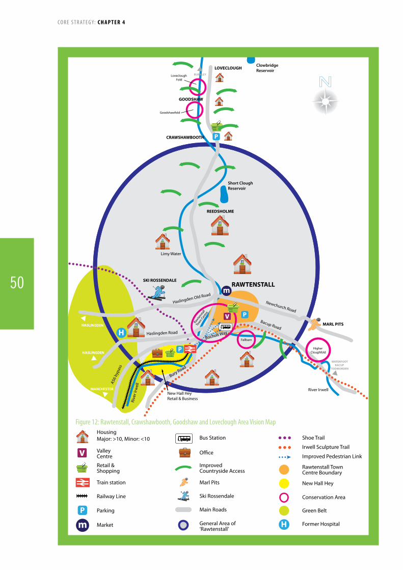
Bacup Road
Newchurch Road
Haslingden Old Road
Haslingden Road
CRAWSHAWBOOTH
REEDSHOLME
GOODSHAW
LOVECLOUGHBURNLEY
MANCHESTER
WATERFOOTBACUP
TODMORDEN
HASLINGDEN
HASLINGDEN
Rive
r Irw
ellA5
6 by
pass
New Hall HeyRetail & Business
Bury Road
Bocholt Way
Higher Cloughfold
Fallbarn
Goodshawfold
Rawte
nstall
Town C
entre
Loveclough Fold
River Irwell
Limy Water
RAWTENSTALLm
H
P
P
PMARL PITS
SKI ROSSENDALE
Short CloughReservoir
Clowbridge Reservoir
HousingMajor: >10, Minor: <10
Retail & Shopping
ValleyCentre
Train station
Parking
Market
Railway Line
P
Bus Station
Improved Countryside Access
O�ce
Marl Pits
Ski Rossendale
Shoe Trail
Improved Pedestrian Links
Irwell Sculpture Trail
Rawtenstall TownCentre Boundary
New Hall Hey
Green Belt
Former Hospital
Main Roads
General Area of‘Rawtenstall’
Conservation Area
m H
Figure 12: Rawtenstall, Crawshawbooth, Goodshaw and Loveclough Area Vision Map
C O R E S T R AT E G Y: CHAPTER 4
50

Policy Target Trigger Indicator Contingencies
AVP4 Hospital site to be developed by 2017
No discussions with developer/owner about scheme detail including mixed use opportunities by 2012Development/designnotproposed by 2013Application not submitted by 2014 in accordance with the SiteAllocationsDPDApplication not approved by 2015Developmentnotcompletedby 2017
Progress with pre-applications and discussions Progress on development and design briefProgress planning applicationsProgress of development
Identify the problem and barriers/causes to development via discussions and/or assessment(s)Including viability assessmentWork with developer land owner to produce a viable and suitable scheme (e.g. negotiating amount and type of non-residential mixed use site and negotiate S106’s)Work with developer/land owner to alleviate constraints (e.g. amount of site to be developed (area) amount/parts of original workhouse to be retained) in accordance with PPG2
AVP4 Bus Station and Public Realm improvements to be completed by 2015
Redevelopment of Rawtenstall Bus Station and Public Realm improvements not an identified specific project in LTP3 by 2012Application not submitted in 2013Application not approved by end of 2013Redevelopment not complete by 2015
Progress with LTP3Progress with planning applicationProgress of building works/redevelopment
Identify the problem and barriers/causes to development via discussions and/or assessment(s)Work with LCC to facilitate and enable development (e.g. assistance with funding and resources)Work with LCC to alleviate constraints (e.g. demolition and relocation of business etc)Assist with the production of a public realm improvement planDevelopMasterPlan/developmentbriefto guide future proposals and assist with securing funding
AVP4 New Hall Hey development to be completed by 2016
No discussions with owners and developer about the scheme details including funding by 2013Initial phases not complete by 2015Redevelopment not complete by 2015
Progress with discussions and fundingProgress with binding agreementStart and completion of phases
Identify the problem and barriers/causes to development via discussions and/or assessment(s)Work with developer and owners to facilitate and enable development (e.g. recognition of S106 and conditions)Work with owner/developer to alleviate constraints (e.g. indicative phasing)Assist with marketing the site and proactive talks
138. The maps identify broad areas of potential development and protection and have been informed by a series of assessments and studies. The maps do not seek to allocate land for specific uses or signal that planning applications would be approved for the types of development indicated.
139. The Area Visions and Policies should not be read in isolation, they act as a guide for future development in the area, but proposals and allocations will be determined in line with the other policies in the Core Strategy.
Monitoring and Implementation
C O R E S T R AT E G Y: CHAPTER 4
51

Vision140. the rural character and nature of individual settlements within the area will have grown and developed into better linked and sustainable communities. the area will support the wider tourism and leisure opportunities within rossendale with appropriately located facilities and services. this will in turn be supported by improved access to the countryside and the conservation of local heritage.
141. the majority of previously-developed sites and buildings will have been developed for necessary and sustainable uses, contributing to the atmosphere and community spirit of the area. some additional employment and housing development will act to support the local economy and provide local people with a choice of employment and residential opportunities.
Area Vision for South-West Rossendale
AVP 5: Strategy for South-West Rossendale
The vision for South West Rossendale will be achieved through:
Environmental Protection Carefulconsiderationoflocalfloodriskissuesinthedeterminationofallnewdevelopment,especiallyinareasofhighrisksuchasIrwellValeand Lumb and Ewood Bridge/
Protecting and where possible enhancing the Hodge Clough and Lower Red Lees Pasture Sites ofSpecialScientificInterest(SSSIs).
Heritage Conservationandenhancementofdistinctlocalheritage,especiallyintheconservationareasofIrwellValeandLumb,ChattertonandStrongstry.
Tourism and Leisure Promotionofoutdoorrecreationsuchas:
TheIrwellSculptureTrail The East Lancashire Railway including the haltinIrwellVale
TheRiverIrwell Haslingden Grane and reservoirs Othercountrysiderightsofways,includingthecompletionofthenationalcycleroutefromStubbinstoHelmshore.
Supported by appropriately located small scale overnightaccommodation,localshops,cafesand
othernecessaryfacilitiesincludinglimitedparkingprovision.
Transport LandinthevicinityofEwoodBridgebeing
investigated as a possible “Park and Ride” site to support the Manchester to Rawtenstall commuter line.
Increasedandimprovedmanagementofthelocalinfrastructureandtransportprovision.
Housing Development Limited residential development on previously developedlandandinfillsites(betweenbuiltupareasanddevelopments)inEdenfield,EwoodBridgeandStubbinswillbesupported,andaffordablehousingneedswillbemet.
Larger housing and employment schemes in suitable locations and where possible on previouslydevelopedland,accommodatedinHelmshore; supported by improvements to local communityfacilitiesandinfrastructure.
An SPD/Masterplan/Neighbourhood Plan will be produced to guide the overall planning and development of part(s) of the South-West.
C O R E S T R AT E G Y: CHAPTER 4
52

Background
142. South-West Rossendale encompasses the settlements of Helmshore, Edenfield, Irwell Vale and Lumb, Ewood Bridge and Stubbins. The area is sparsely populated with the majority of residents living in the aforementioned settlements separated by Green Belt and countryside. Outside these settlements there are several rural communities scattered across the landscape, but which due to accessibility and land designation issues are not highlighted for any significant planned changes.
143.Developmentintheareaasawholeowesmuchofitsexistence to the damp hilly environment, which was ideal for the wool and cotton trades that grew with the Industrial Revolution, starting with small mills in the late 1700s and later developed into large industrial textile mills by the latter half of the nineteenth century.
144. Today the local landscape in the area is dominated by Scout Moor wind farm (the largest on shore wind farm in England as of 2010) to the east and Peel Tower on Holcombe Moor to the west making for very unique surroundings.
145. Attractive surroundings coupled with a buoyant housing market and good access to Manchester and other regional cities and economic hubs, has resulted in a significant increase in new housing to support the influx of people moving to Rossendale and working elsewhere. This area of the Borough is one of the most affluent in the sub-region.
Strengths, Opportunities and Key Issues
Issues Strengths and Opportunities
Constrained by the Green Belt
Significant development pressures, which could lead to an erosion of the area’s character and appeal
Access and Infrastructure – much of the area is only accessible by private vehicle, and many of the roads are unadopted and poorly maintained, making some routes difficult to navigate
Flood Risk – the area has a history of flooding and the Strategic Flood Risk Assessment (SFRA) illustrates that this is a key issue for much of the area
Increasing Visitor Traffic – the area is riddled with footpaths, cycle tracks, bridleways attracting increasing numbers of visitors, adding to the existing pressure on roads and services
Excellent transport links to Manchester and wider region
Strong and attractive housing market
Picturesque environment and access to the countryside including the Irwell Sculpture Trail, Rossendale Way and other Countryside Rights of Way (CROWs)
East Lancashire Railway halt in Irwell Vale
Distinctlocalheritage Good access from
Helmshore to Haslingden Grane for Ogden Reservoir and Holden Wood
C O R E S T R AT E G Y: CHAPTER 4
53

RAWTENSTALL
HASLINGDEN
HASLINGDENACCRINGTON
MANCHESTERRAMSBOTTOMBURY
SEW
AGE
WO
RKS
HELMSHORE
EDENFIELD
LUMB
IRWELL VALE
HodgeClough
EWOODBRIDGE
STUBBINS
CHATTERTON& STRONGSTRY
Rochdale Road
Bury RdW
halley Road
Helm
shore Road
Hel
msh
ore
Road
Holcom
be Road
Grane Road
Blac
kbur
n Ro
ad
Manchester Road
A56
River Ogden
Bolton Rd N
th
Market St
Bury Road
Blac
kbur
n Ro
ad
M66
A56
Rive
r Irw
ell
Lower RedLees Pasture
HousingMajor: >10, Minor: <10
Main Roads
Green Belt
Park and Ride
Irwell Sculpture Trail
Conservation Area
Site of Special Scienti�c Interest (SSSI)
Improved Countryside Access
Railway Line
Urban/Built-up Area National Cycle Route 6Stubbins to Helmshore
Figure 13: Southwest Rossendale Area Vision Map
C O R E S T R AT E G Y: CHAPTER 4
54

Policy Target Trigger Indicator Contingencies
AVP5 Completion of the national cycle route from Stubbins to Helmshore by 2015
Route not included in LTP 3 by 2011Route not in LCC’s Implementation Strategy for Rossendale (September 2011)No contractor appointed by April 2014
DiscussionswithLancashire County Council
Identify the problem and barriers/causes to development via discussions and/or assessment(s)Include viability assessmentIdentify alternative sources of fundingDiscusssolutionstootheridentifiedconstraintswhich are delaying progress with various stakeholders e.g. land owners, LCC etc.
146. The maps identify broad areas of potential development and protection and have been informed by a series of assessments and studies. The maps do not seek to allocate land for specific uses or signal that planning applications would be approved for the types of development indicated.
147. The Area Visions and Policies should not be read in isolation, they act as a guide for future development in the area, but proposals and allocations will be determined in line with the other policies in the Core Strategy.
Monitoring and Implementation
C O R E S T R AT E G Y: CHAPTER 4
55

Vision148. Haslingden and rising Bridge will be attractive places to live and work for all sections of the community. New housing and employment development will be encouraged within the urban boundary and should be primarily on previously developed land. In the countryside improved access and management will help to contribute to resident’s enjoyment of the area.
149. Haslingden Centre will be rejuvenated with reduced numbers of vacancies and a broad range of shops. Deardengate will be made more attractive for users including improved public space works.
Area Vision and Policy for Haslingden and Rising Bridge
AVP 6: Strategy for Haslingden and Rising BridgeThe vision for Haslingden and Rising Bridge will be achieved through the following:Housing and Employment Sites Newresidentialdevelopmentwillbeprimarilylocatedonpreviouslydevelopedlandandreflectlocalrequirementsforaffordablehousing.
EconomicdevelopmentwillcontinuetobefocusedontheCarrsandBroadwayindustrialestatesandwillbesafeguardedforofficeandlightindustry,generalindustryandstorageanddistribution(B1,B2andB8)andtheBusinessHubatRisingBridgewillbesafeguardedforoffice(B1)uses.Accessbybusandcyclewillbeenhanced.
Heritage AConservationAreawillbedesignatedforthetowncentrearea.
Town Centre AvacantbuildingsstrategywillbedevelopedandimplementedforHaslingdentowncentre. Deardengate,Haslingdenwillbeenhancedbythefollowingmeasures:
Improvementstopublicspace Pavement widening using materials appropriate to the Conservation Area Trafficmanagementmeasuresincludingcyclefacilitiesandparkingprovision ThePrimaryShoppingArea(PSA)willbepromotedforA1andA2uses. Afocusonenhancingshopfrontsincludingaconsistentapproachtodesignofshutters
FurtheranalysisofthiscentreanditspotentialfuturestatuswillbeaddressedthroughtheAllocationsDPD.
Tourism and Leisure Tourismproposals(includingaccommodation)willbesupportedthroughmeasuressuchasimprovedsignageandpublicaccesstoattractionssuchastheHaloPanopticanandHaslingdenGrane.
HaslingdenLeisureCentrewillbefurtherdevelopedasacommunitysportsandleisurefacilityforthewesternpartoftheBorough
CompletionofthenationalcycleroutefromHelmshoretoRisingBridge.
An SPD/Masterplan/Neighbourhood Plan will be produced to guide the overall planning and development of part(s) of Haslingden and Rising Bridge
C O R E S T R AT E G Y: CHAPTER 4
56

Background
150. Haslingden and Rising Bridge have seen considerable housing and employment growth in recent years though the Urban Boundary and Green Belt protection have limited encroachment into the countryside. Because of its good external links via the A56 the area is attractive to commuters and businesses leading to pressure to build on greenfield sites as well as previously developed land. Existing industrial sites require refurbishment.
151. Haslingden has a long shopping centre mostly focussed onDeardengatewithalargenumberofindependenttraders.There are however substantial numbers of vacancies and a concentration of hot food takeaways.
152. The “Halo” Panoptican has raised the profile of the area though improved signage will need to be installed. The west of the area including Haslingden Grane is within the West Pennine Moors Management Area and offers increased opportunities for walking and other leisure activities. Haslingden Pool is an important leisure resource.
Strengths, Opportunities and Key Issues
Issues Strengths and Opportunities
Amount of vacant and derelict buildings and land – particularly in Haslingden town centre
Number of hot food takeaways in Haslingden town centre
No pedestrianised shopping area(s)
No single focal point for community
Developmentpressureson the countryside
Lack of housing choice Tightly-knit urban area
– constraining amount of developable sites
Lack of leisure, cultural and recreation facilities
Well linked accessible employment sites – Carrs Industrial Estate and Broadway, and the business hub at Rising Bridge.
Excellent quality bus services – Accrington to Manchester X40 and X41
Halo Panoptican and increased tourism interest
Access to the countryside including the Shoe Trail and Kings Highway as well as Haslingden Grane
Abundance of local history and heritage including several Commemorative Blue Plaques
C O R E S T R AT E G Y: CHAPTER 4
57

HASLINGDEN
RISINGBRIDGE
Haslingden
Old Road
Haslingden Road
A56
Broadway
Grane Road
Holcom
be Road
Roundhill Rd
Blackburn Rd
Blackburn Rd
Manchester Rd
A56
A56
A56
Hel
msh
ore
Rd
P
Deardengate
Top o’Slate
ACCRINGTON
BURNLEYACCRINGTON
TO M65
EDENFIELDMANCHESTER
RAWTENSTALL
STUBBINSIRWELL VALE
LUMB
m
HousingMajor: >10, Minor: <10
Main Roads
Haslingden Market
Halo Panopticon
SafeguardedEmployment Sites
Green Belt
Haslingden Leisure Centre
Shoe Trail
Proposed Conservation Area
Improved Countryside Access
District CentreBoundary
m Urban/Built-up Area
Figure 14: Haslingden and Rising Bridge Area Vision Map
C O R E S T R AT E G Y: CHAPTER 4
58
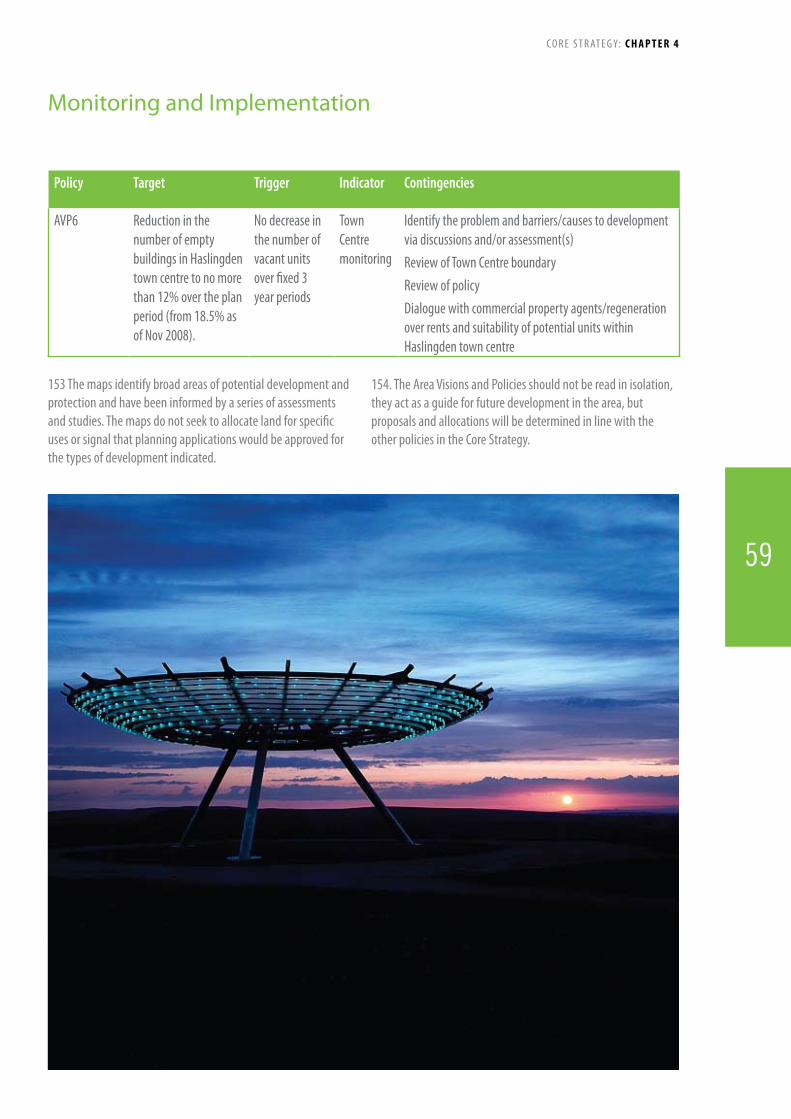
59
Policy Target Trigger Indicator Contingencies
AVP6 Reduction in the number of empty buildings in Haslingden town centre to no more than 12% over the plan period (from 18.5% as of Nov 2008).
No decrease in the number of vacant units over fixed 3 year periods
Town Centre monitoring
Identify the problem and barriers/causes to development via discussions and/or assessment(s)Review of Town Centre boundaryReview of policyDialoguewithcommercialpropertyagents/regenerationover rents and suitability of potential units within Haslingden town centre
153 The maps identify broad areas of potential development and protection and have been informed by a series of assessments and studies. The maps do not seek to allocate land for specific uses or signal that planning applications would be approved for the types of development indicated.
154. The Area Visions and Policies should not be read in isolation, they act as a guide for future development in the area, but proposals and allocations will be determined in line with the other policies in the Core Strategy.
Monitoring and Implementation
C O R E S T R AT E G Y: CHAPTER 4
59

CHaPtEr 5topic Planning Policies
Rossendale in 2026155. Topic Planning Policies set out the Council’s approach to particular types of development. They will apply to all developments of that type and set the standards that the Council will expect proposals to meet. The policies should be read as a whole and are not set out in any specific order or level of priority.
156. Planning deals with all types of development, so there are many topics. However the Topic Planning Policies in the Core Strategy include policies that specifically or indirectly cover the following issues:
General Development Locations
Development Principles
The Natural Environment
Housing
Economy & Employment
Tourism
Retail and Town Centre Uses
Social & Community Facilities
Transport
Infrastructure
Health
Education
Climate Change
The Built Environment
157. The Topic Planning Policies will set out:
What - we plan to do about the topic (e.g. the built environment)
Why - we need to do something about it
How - we plan to achieve this
When - (broadly) we anticipate this being completed
Who - will deliver/provide it
158. The Topic Planning Policies are designed to cover development across Rossendale and are therefore quite broad. Further guidance on Topic Policies may be developed through later Local Development Documents (e.g. Supplementary Planning Documents).
60
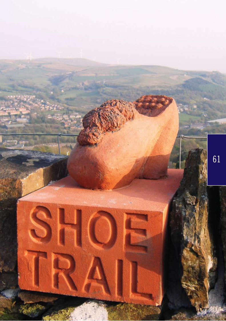
61
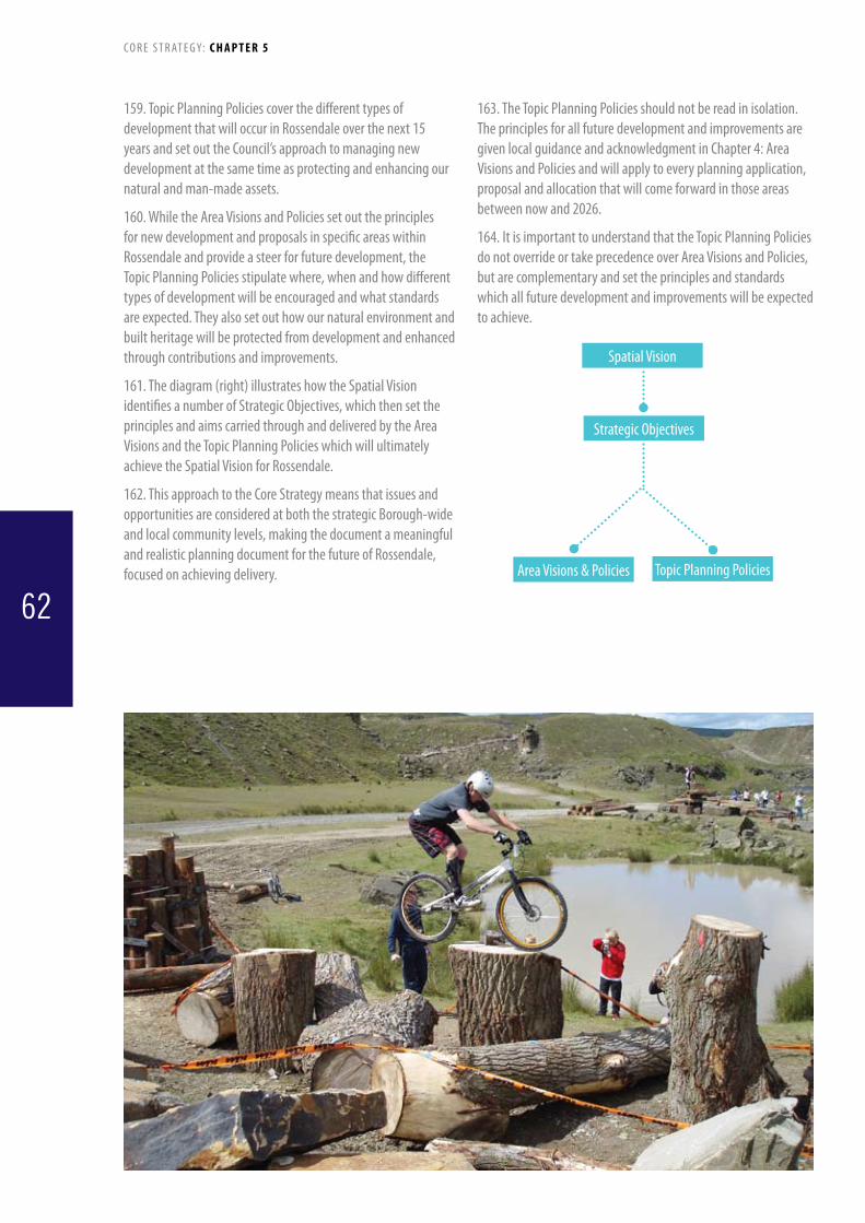
62
159. Topic Planning Policies cover the different types of development that will occur in Rossendale over the next 15 years and set out the Council’s approach to managing new development at the same time as protecting and enhancing our natural and man-made assets.
160. While the Area Visions and Policies set out the principles for new development and proposals in specific areas within Rossendale and provide a steer for future development, the Topic Planning Policies stipulate where, when and how different types of development will be encouraged and what standards are expected. They also set out how our natural environment and built heritage will be protected from development and enhanced through contributions and improvements.
161. The diagram (right) illustrates how the Spatial Vision identifies a number of Strategic Objectives, which then set the principles and aims carried through and delivered by the Area Visions and the Topic Planning Policies which will ultimately achieve the Spatial Vision for Rossendale.
162. This approach to the Core Strategy means that issues and opportunities are considered at both the strategic Borough-wide and local community levels, making the document a meaningful and realistic planning document for the future of Rossendale, focused on achieving delivery.
163. The Topic Planning Policies should not be read in isolation. The principles for all future development and improvements are given local guidance and acknowledgment in Chapter 4: Area Visions and Policies and will apply to every planning application, proposal and allocation that will come forward in those areas between now and 2026.
164. It is important to understand that the Topic Planning Policies do not override or take precedence over Area Visions and Policies, but are complementary and set the principles and standards which all future development and improvements will be expected to achieve.
C O R E S T R AT E G Y: C H A P T E R 5
Spatial Vision
Topic Planning Policies
Strategic Objectives
Area Visions & Policies
62

Policy 1: General Development Locations and PrinciplesThe Council will seek to maintain Rossendale’s distinctive environment through implementing the following approach for all types of development.General Development LocationsThegreatestamountofnewdevelopmentshouldtakeplaceinRawtenstallwiththemajorityofotherdevelopmenttakingplaceinBacupandHaslingden.Urban Boundary Development within Rossendale should take place within thedefinedurbanboundary(LocalPlanSavedPolicyDS1),unlessithastobelocatedinthecountryside,andshouldbeofasizeandnatureappropriatetothesizeandroleofthesettlement.TheurbanboundarydefinedinLocalPlanSaved Policy DS1 will be reviewed and where necessary amended in the Site Allocations DPD in accordance with thefollowingcriteria:• Recentdevelopmentdictatesanecessarychangetothe
boundary• Anomaliesandinconsistenciesindicatethat
amendments need to be made• Anextension/amendmenttotheurbanboundary
wouldnotadverselyaffectaspectsofthenaturalenvironmentsuchasbiological,geological,geomorphological,greeninfrastructureandlandscapecharacterassets,includinghabitatsandspeciesofimportancefornatureconservationorshouldbecapableoffullmitigation
• Anyamendment/extensionwouldnotresultintheamalgamationofsettlements
• Theamendment/extensionwouldnotresultinasignificantimpactonlocalviewsandviewpoints
Green Belt & CountrysideProposals outside the urban boundary will be determined in accordance with the relevant national and local planningguidance:• TheformerRossendaleHospitalsite,offHaslingden
Road,isdesignatedasaMajorDevelopedSiteintheGreenBelt.DetailedboundariesanddevelopmentcriteriawillbeincludedintheSiteAllocationsDPD.Thefootprintoftheexistingbuildingswillformthestartingpointforconsiderationofanyproposal.
AreviewoftheexistingGreenBeltboundaries(LocalPlanSavedPolicyDS3)intheareasshownonFigure(numbertobedetermined)willbeundertakenaspartoftheSiteAllocationsDPD.Thereviewwillbelimitedtosmallscale changes and cartographic corrections that do not adverselyimpactonthepurposesofincludinglandintheGreenBelt.The review will be based on a consistent process that reflectscurrentnationalguidance.AnychangestotheGreenBeltwouldonlybemadeinexceptional
circumstancesandwouldtakeintoaccounteachofthefollowingcriteria:• Effectonopenness• TheoverallintegrityoftheGreenBelt• Checkingtheunrestrictedsprawloflargebuilt-upareas
and other settlements• Thesignificanceoflocalandlongerdistanceviewsinto
andoutofthesite• Preventingneighbouringtownsandvillagesmerging
into one another• Themaintenanceofanappreciableopenzonearound
andbetweenbuilt-upareas• Thesafeguardingofthecountrysidefromencroachment• Topreservethesettingandspecialcharacterofhistoric
towns and settlements• Whetheritassistsurbanregenerationbyencouraging
therecyclingofderelictandotherurbanland• WheresmallscaleselectiveroundingoffofGreenBelt
boundaries would promote sustainable development opportunities.
Overall Development ApproachTheCouncilwillseektoenhancethequalityandsustainabilityofplacesandindividualdevelopmentsbytakingintoaccountthefollowingcriteriawhenpreparingLDF documents and considering individual planning applications:• Makebestuseofunder-used,vacantandderelictland
and buildings• Complementandenhancethesurroundingarea(s)of
thedevelopmentthroughtheuseofinclusivedesignand locally distinctive materials which enhances the characterandheritageofRossendale
• Minimisenegativeimpactsuponexistinginfrastructurecapacitiesbyconsideringitscapacitylevelsandplansforfutureupgradesandexpansion
• Takingaprecautionaryapproachtofloodrisk• Theneedtoensurethatmineralresourcesarenot
needlessly sterilised by new development• Maximiseenergyefficiencyanddemonstrateeffective
useoflowcarbontechnologies• Maximiseaccessbypublictransport,walkingand
cyclinginamannerthatpromotessafeandinclusivecommunitiesandpromoteco-locationofservicesandfacilities
• Enhanceandprotectthecountryside,geodiversityandbiodiversity resources including habitats and species
• Whereverpossible,improvetheamountof,linkstoandthequalityofthelocalnetworkofopenspacesandgreeninfrastructure
• Contributestomaintainingandcreatingsustainableand inclusive communities
C O R E S T R AT E G Y: C H A P T E R 5
63
165. Rossendale has a distinctive settlement pattern that this policy seeks to both maintain and enhance. The urban area primarily consists of a string of individual settlements along the valleys that merge into each other. Rawtenstall is the largest settlement with the best transport links and is the main retail and service centre for the Borough. Because of this function and the potential demand for new development that would be stimulated if the East Lancashire Railway was re-opened for commuter use it is proposed that the greatest amount of development should be located here. Bacup is the main centre for the east of the Borough and is a focus for regeneration, with a particular emphasis on maximising the potential of its historic buildings and promoting development that will meet the needs of the local population. Haslingden has excellent external links via the A56 and contains a number of key employment locations. The town centre is in need of enhancement that reflects its historic context.
166.Developmentinothersettlementsisexpectedtobeprimarily focused in Whitworth. Other areas such as Stacksteads, Waterfoot, Helmshore and Edenfield will play a supporting role. Improvements and increases to existing housing, employment, retail and service provision will be supported at an appropriate scale as identified in other policies in this document. In smaller settlements such as Goodshaw, Loveclough, Irwell Vale, Water and Weir the level of development should primarily support and relate to local needs.
167. There is a considerable amount of vacant, under-used and previously developed land and buildings. This can be found in virtually all settlements with a significant proportion in Rawtenstall, as well as Bacup, Haslingden and Whitworth. Re-use of this resource will help improve the quality of the local environment as well as help to reduce the pressure to build on greenfield, peripheral locations.
168. The focus on urban areas is not intended to prohibit necessary development in rural areas such as that which is essential for agriculture and related activities, tourism, sports and leisure and small scale business purposes. Wherever possible such development should be located in villages unless it can be demonstrated that a location in the open countryside is required (see Policy 21). The intention is to ensure that the qualities that make the countryside of the area distinctive are retained. Alterations to existing buildings in the countryside, such as barns, areaddressedinthe“Re-useofBuildingsintheCountryside”SPD.The existing urban boundary will be reviewed as part of the Site AllocationsDPDinordertoreflectchangesonthegroundsincethe Local Plan was adopted in 1995. It is anticipated that the changes will primarily take the form of “rounding off” to reflect the local context and take into account where any opportunities for sustainable development exist.
169. Substantial parts of the Borough, particularly in the south west and around Whitworth, were designated as Green Belt in the North East Lancashire Structure Plan adopted in November 1979.Detailedboundarieswereestablishedinthe1982LocalPlan
with only minor changes made as part of the 1995 Rossendale DistrictLocalPlan.ThemainpurposesoriginallyidentifiedintheStructure Plan for including land in the Green Belt were to protect settlements from coalescing, manage urban sprawl and create recreational opportunities. These purposes have not changed while pressures for development, especially in attractive areas such as South West Rossendale remain high. The landscape setting of settlements set in steep sided valleys is an essential element of the Borough’s character. PPG2 also identifies the Green Belt’s role to assist in urban regeneration, by encouraging the recycling of derelict and other urban land. Rossendale has a significant supply of previously developed land.
170. Existing Green Belt boundaries will subject to a limited Review in the areas defined on Figure 15 page number 66. The areas identified are those where the Council considers that one or more of the following applies a) Minor cartographic changes are required, e.g. Stacksteads b) Existing settlement inset boundaries may be excessively tight, e.g. Edenfield and Whitworth c) small scale changes would support sustainable patterns of development, e.g. Rawtenstall and Rising Bridge.
171. The Review of Green Belt boundaries will be undertaken as partoftheSiteAllocationsDPD.Itwillconsidersmallscalelocalboundary amendments where this would not adversely affect the openness of the Green Belt, increase urban sprawl and affect recreational opportunities. All sites to be considered would be appraised using a detailed methodology based around the 5 purposes of including land in the Green Belt. Minor boundary amendments that would assist in the assembly of development sites that are sustainable and would not impact the purposes of including land within the Green Belt will be considered. All changes will be exceptional and will not impact on the general extent of the Green Belt.
172. The former Rossendale Hospital site is designated as a Major DevelopedSiteintheGreenBelt.Thisreflectsthepotentialforredevelopment and the importance of ensuring the longer term environmental improvement of the site. The local significance of the original Victorian Workhouse building should be assessed andrecognisedinproposalsforredevelopment.Developmentshould be based on the existing building footprint reflecting guidance in Planning Policy Guidance Note 2 (PPG2) “Green Belts”.DevelopmentofthesiteasawholeshouldbeguidedbyproductionofaDevelopment/DesignBrieforMasterplaneitherprior to submission of an application or as part of a planning application.
173. Promoting sustainable development is a key focus of theCoreStrategyandisreflectedintheOverallDevelopmentApproach. These will form the basis for analysis of sites in a futureSiteAllocationsDevelopmentPlanDocumentandsetsgeneral principles for the preparation of Supplementary Planning Documents(SPD’s).ForindividualplanningapplicationstheOverallDevelopmentApproachshouldbereadalongsidePolicy23:PromotingHighQualityDesignandSpacesandPolicy24:
C O R E S T R AT E G Y: C H A P T E R 5
64

reduce the impact of new development on the utilities networks as well as reducing the existing high per capita production of CO².
177. The high level of car usage together with concentrations of low car ownership means that new development should be made as accessible as possible by alternative means. Locations within 400 metres of bus stops on primary bus corridors will be particularly favoured. The narrow Victorian road network means that large areas are difficult to access by large vehicles, including refuse vehicles. New development should create attractive, safe streets and also take into account the ability to service the area. The latter will be particularly important for refurbishment of older employment premises. The location of services and facilities with housing and employment can all help reduce the need to travel.
178. The use of appropriate local materials, labour and suppliers for building will be pursued. This would both reduce the building’s carbon footprint and to encourage development that reflects the local context.
Planning Application Requirements.
174. Effective management and utilisation of existing infrastructure is fundamental to effective implementation of the Core Strategy and has been taken into account during the preparation of this document. There are, for example, local constraints on the highway network and the utilities infrastructure which will require full consideration as part of the SiteAllocationsDPD.
175. Use of high quality materials, the enhancement of historic buildings and places, and the relationship with open space, natural habitats, waterways and the Rights of Way network (“green infrastructure”) are all particularly important in the local context. The steep valley sides and views from moorland ridges mean that medium/longer distance views from above can be significant.
176. The damp climate of Rossendale combined with the topography results in locally significant problems with surface waterrun-off.Developmentsshouldexamineoptionsforsustainable drainage systems. Significantly greater energy efficiency in refurbished as well as new buildings would help to
Policy Target Trigger Indicator Contingencies
1 95% of all new housing units, excluding Major DevelopedSitesinthe Green Belt, to be built within the urban boundary defined in the SiteAllocationsDPD over plan period up to 2026
85% or less of housing numbers in the urban boundary over a rolling 3 year period
Number of housing units built/delivered in the urban boundary annually
Identify the problem and barriers/causes to development via discussions and/or assessment(s)Work with key partners, including Rossendale BC, to identify sites which can be built in 2-3 years and work with them to submit successful applications to meet deficitWork with developers/landowners of sites to bring sites forward faster (e.g. via development phasing, affordable phasing and completion notice) Consider commencing a review of the Policy
1 95% of all new retail and office floorspace delivered within the urban boundary defined in the Site Allocations DPDovertheplanperiodup to 2026
85% or less of retail and office floorspace delivered in the urban boundary over a rolling 3 year period
Amount of retail and employment floorspace built/delivered in the urban boundary annually
1 40% of all retail and office floorspace to be provided in Rawtenstall
Less than 10% or more than 50% of overall retail and/or office floorspace provided in Rawtenstall over a 3 year rolling period.
Amount of retail and office floorspace built/delivered in Rawtenstall annually
Identify the problem and barriers/causes to development via discussions and/or assessment(s)Work with key partners, including Rossendale BC, to encourage development in the area including assisting with access to funding and resourcesWork with partners to identify sites which can be built in 2-3 years and work with them to submit successful applications to meet deficitConsider a review of the Policy
1 30% of all new residential development to be built in Rawtenstall over the plan period to 2026
Less than 10% or more than 50% of all new residential development delivered in Rawtenstall over a 3 year rolling period.
Number of housing units delivered in Rawtenstall annually
C O R E S T R AT E G Y: C H A P T E R 5
65
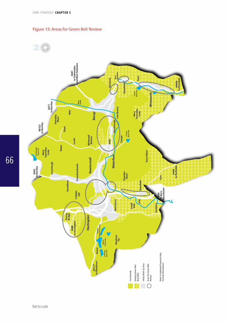
Brita
nnia Ri
ver
Spod
den
Rive
rIr
wel
l
Crib
den
Hill
Goo
dsha
wRi
sing
Brid
ge
Craw
shaw
boot
h
Love
clou
gh
Mar
yTo
wne
ley
Loop
A68
2to
Bur
nley
B632
3to
Bur
nley
A67
1to
Bur
nley
Wat
erD
ean
Raw
tens
tall
Wat
erfo
ot
Bacu
p
Whi
twor
th
Has
lingd
en
Dee
rpla
yM
oor
Wei
r
Lum
b
Whi
tew
ell
Bott
om
Stac
kste
ads
Lee
Qua
rry
A68
1to
Tod
mor
den
and
Wes
t Yor
kshi
re
Shaw
fort
h
Faci
t
Mar
yTo
wne
ley
Loop
Cow
pe
A68
1
Scou
t Moo
r
A60
66to
Roc
hdal
e
Dea
rden
Moo
r
A68
0to
Acc
ring
ton
Hol
den
Woo
d Re
serv
oir
Cow
pe
Rese
rvoi
r
Cow
m
Rese
rvoi
r
Clow
brid
geRe
serv
oir
Ogd
en
Rese
rvoi
rCa
lf H
ey
Rese
rvoi
r
A61
77to
Bla
ckbu
rnG
rane
A56
Mus
bury
Tor
Turn
Eden
�eld
Stub
bins
M66
to B
ury
& M
anch
este
r
Hel
msh
ore
Irw
ell
Vale
A68
0to
Roc
hdal
e
Figure 15: Areas for Green Belt Review
Not to scale
Coun
trys
ide
Exis
ting
Gre
en B
elt
Boun
dary
Urb
an/B
uilt
Up
Are
a
Are
as fo
r Gre
en B
elt
Revi
ew
Refe
r to
Adop
ted
Prop
osal
s M
apFo
r Exa
ct B
ound
arie
s
C O R E S T R AT E G Y: C H A P T E R 5
66

Policy 2: Meeting Rossendale’s Housing Requirement
The net housing requirement for the period 2011-2026, will be achieved through:1. Providing at least 3700 net additional dwellings over the plan period 2011-2026
equating to 247 dwellings per year2. Allocating greenfield and previously developed land to meet the requirement for
the period 2011-2026 to meet identified type, size and tenure needs; including indicative phasing where appropriate
3. Delivering an overall amount of 65% of all new dwellings on previously developed land (PDL) across the Borough. Rawtenstall will have a lower PDL figure, with substantially higher levels in Bacup, Haslingden and Whitworth
4. Supporting the reuse and conversion of appropriate buildings for housing5. Encouraging higher density developments (50+ dwellings per hectare) in
sustainable locations, such as within and adjacent to Rawtenstall, Bacup, Haslingden and Whitworth and where well served by public transport, with a minimum density of 30dph across the Borough
6. Safeguarding the character of established residential areas from over-intensive and inappropriate new development; and
7. Prioritising the development of previously developed land. However, development of un-allocated greenfield land will be permitted where:
i. It is for 100% affordable and/or supported housing schemes; or ii. It forms a minor part (up to 15% of the overall site size) of a larger mixed use scheme or a major housing proposal (10+ dwellings) on
previously developed land or iii. It delivers a significant social, economic, or environmental benefit, or iv. The application is for a barn conversion and it can be demonstrated that the
site has been marketed for economic uses for 12 months, to the satisfaction of the Council, and is not viable for these purposes
C O R E S T R AT E G Y: C H A P T E R 5
67

179. Planning Policy Statement 12: Local Spatial Planning requires that Core Strategies should provide a policy basis for at least 15 years from the date of adoption.
180. The Regional Spatial Strategy for the North West (RSS) sets out the housing requirement which should be met by the Council. Whilst the government has made clear its intention to abolish RSSs, until this happens, the Council has a duty to prepare a Core Strategy which is in general conformity with the RSS. The Council is satisfied that this requirement has been satisfied. The Strategic Housing Market Assessment which informed the RSS was preparedinaccordancewithDCLGguidanceandwasbasedon2004 data. The study accepted that it did not necessarily provide the level of detail needed at a local level to inform local planning and housing policies and advised that it should be read alongside more local assessments.
181. Although it was not adopted until 2008, the RSS sets targets for the period 2003-2021. The annual requirement for Rossendale identified in the RSS is 222 dwellings a year. The Council supported the original Option 1 figures during the preparation of the RSS which was justified by the evidence base, including population forecasting and housing market growth, etc. The Council’s own SHMA which was used to inform the Core Strategy was prepared in 2008. Whilst this concluded that the annual housing requirement was higher than that set out in the RSS it also pointed out that, for a variety of reasons, this was not necessarily a compelling argument for changing the requirement. In these circumstances the Council has decided that the RSS annual target is realistic and that it should be retained. The Council has extrapolated the annual requirement set by the RSS forward to 2026, giving a minimum requirement over the whole of the plan period of 3330.
182. Historically housing completion rates have only occasionally exceeded 222. The reasons for this are likely to be diverse. However, since the beginning of the RSS plan period in 2003, housing provision was constrained by Policy 12 of the (former) JointLancashireStructurePlanwhichsetmaximumannualhousing provision targets of 220 between 2001 and 2006 and 80 during 2006 and 2016. In the years 2003/4 to 2005/6 housing completions averaged about 220 a year. However, during 2006 and 2008 the degree of housing restraint imposed by the Structure Plan meant that completions fell well below the target levels subsequently set by the RSS. This should not be treated as a shortfall against targets. The purpose of the Structure Plan’s restraint policy was not to prevent requirements from being met but rather to divert the housing provision to areas where regeneration would deliver greater benefits. In these circumstances, assuming that the Structure Plan policy was operating successfully, whilst the requirement for additional housing in Rossendale was not being met in Rossendale, it should have been met elsewhere. There should therefore be no actual
shortfall against the housing requirement during that period of restraint.
183. The housing restraint strategy imposed by Structure Plan Policy 12 was removed in 2008 when the RSS was adopted. However, since that time the onset of the economic recession has held back housing provision. At 1st April 2011 the degree of under-provision which had arisen since removal of the housing restraint policy was 365. This shortfall against targets represents an unsatisfied requirement for housing by Rossendale’s population which has built up before 2011. Even though the Core Strategy’s plan period does not commence until 2011, this historic unsatisfied requirement should be recognised and accommodated in the Core Strategy. The Core Strategy therefore makes provision for a minimum housing requirement of 3700 dwellings. It may take some years for the economy to emerge from recession and during this period the shortfall against targets is likely to grow larger. This too will need to be accommodated.
184. Historic records of housing completions tend to indicate that the RSS’s annual requirement of 222 dwellings may be difficult to maintain consistently over the plan period. However, more recent evidence indicates that, prior to the onset of the recession, it was necessary to refuse planning permission for substantial numbers of dwellings because of the housing restraint strategy which was in place. Although it is likely that not all of these proposed developments would have translated into built development, it is possible that house building rates would have been higher if restraints had not been in place. Whilst meeting annual targets for housing provision of more than 222 will be challenging, they would not necessarily be unachievable.
185. Realistically, addressing the shortfall against targets which has arisen since 2008 cannot take place whilst the building industry is emerging from recession. This is unlikely to be before 2013/14. Until that time the shortfall against targets is likely to grow;albeitataslowerrateanditwillbenecessarytoplantosatisfy any growing shortfall against targets. The strategy should seek to plan for increased provision to both satisfy and take advantage of the demand which has built-up as soon as possible. Accelerated rates of housing provision should be planned for the 5 year period commencing in 2013 to bring the provision trajectory back into alignment.
186. It will be necessary to continue to monitor housing completions through the Annual Monitoring Report and updates to the SHLAA and to respond flexibly to deviations from this trajectory as set out in the Implementation Strategy (Triggers and Contingencies). Land, both greenfield and brownfield, to satisfy the housing requirement will be allocated in the Site AllocationsDPD.However,untilthatDPDisprepareditwillbeimportant that the Council ensures that adequate and suitable sites are made available to ensure that sufficient land is readily available for development. This will require a pragmatic approach
C O R E S T R AT E G Y: C H A P T E R 5
68
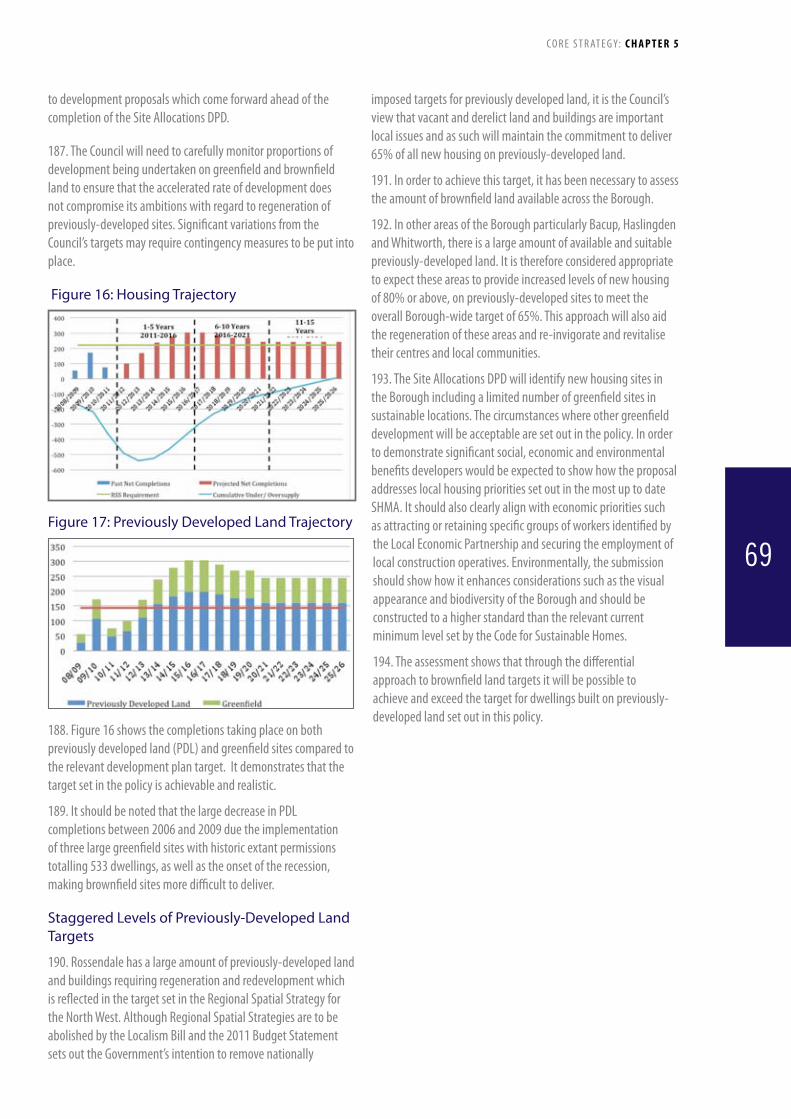
to development proposals which come forward ahead of the completionoftheSiteAllocationsDPD.
187. The Council will need to carefully monitor proportions of development being undertaken on greenfield and brownfield land to ensure that the accelerated rate of development does not compromise its ambitions with regard to regeneration of previously-developed sites. Significant variations from the Council’s targets may require contingency measures to be put into place.
Figure 16: Housing Trajectory
Figure 17: Previously Developed Land Trajectory
188. Figure 16 shows the completions taking place on both previouslydevelopedland(PDL)andgreenfieldsitescomparedtothe relevant development plan target. It demonstrates that the target set in the policy is achievable and realistic.
189.ItshouldbenotedthatthelargedecreaseinPDLcompletions between 2006 and 2009 due the implementation of three large greenfield sites with historic extant permissions totalling 533 dwellings, as well as the onset of the recession, making brownfield sites more difficult to deliver.
Staggered Levels of Previously-Developed Land Targets
190. Rossendale has a large amount of previously-developed land and buildings requiring regeneration and redevelopment which is reflected in the target set in the Regional Spatial Strategy for the North West. Although Regional Spatial Strategies are to be abolished by the Localism Bill and the 2011 Budget Statement sets out the Government’s intention to remove nationally
imposed targets for previously developed land, it is the Council’s view that vacant and derelict land and buildings are important local issues and as such will maintain the commitment to deliver 65% of all new housing on previously-developed land.
191. In order to achieve this target, it has been necessary to assess the amount of brownfield land available across the Borough.
192. In other areas of the Borough particularly Bacup, Haslingden and Whitworth, there is a large amount of available and suitable previously-developed land. It is therefore considered appropriate to expect these areas to provide increased levels of new housing of 80% or above, on previously-developed sites to meet the overall Borough-wide target of 65%. This approach will also aid the regeneration of these areas and re-invigorate and revitalise their centres and local communities.
193.TheSiteAllocationsDPDwillidentifynewhousingsitesinthe Borough including a limited number of greenfield sites in sustainable locations. The circumstances where other greenfield development will be acceptable are set out in the policy. In order to demonstrate significant social, economic and environmental benefits developers would be expected to show how the proposal addresses local housing priorities set out in the most up to date SHMA. It should also clearly align with economic priorities such as attracting or retaining specific groups of workers identified by the Local Economic Partnership and securing the employment of local construction operatives. Environmentally, the submission should show how it enhances considerations such as the visual appearance and biodiversity of the Borough and should be constructed to a higher standard than the relevant current minimum level set by the Code for Sustainable Homes.
194. The assessment shows that through the differential approach to brownfield land targets it will be possible to achieve and exceed the target for dwellings built on previously-developed land set out in this policy.
C O R E S T R AT E G Y: C H A P T E R 5
69

Policy Target Trigger Indicator Contingencies
2 Deliveraminimumof3700newhouses over the plan period to 2026
Shortfall of 20% of cumulative 3 year target according to the housing trajectory in Policy 2
Number of housing units built each year monitored through the Annual Monitoring Report (AMR)
Identify the problem and barriers/causes to development via discussions and/or assessment(s) and decide whether to take action
Bring forward sites indentified for later phases in the plan period if appropriate
Work with Key Partners, developers and landowners to facilitate and enable development (e.g. access to finance, including grants, renegotiating 106’s and contributions)
Consider a review of Policy
2 Delivertherighttype,sizeandtenure (affordable or open market housing) of housing to meet identified needs and demands in line with the latest assessment where appropriate by 2026
80% or less of new housing meeting an identified house type, size or tenure over a rolling 3 year target
Number of housing units built each year by type, size and tenure (affordable or open market housing) monitored through the Annual Monitoring Report (AMR)
Identify the problem and barriers/causes to development via discussions and/or assessment(s) and decide whether to take action
Work with key partners, developers and landowners to encourage development to meet needs
Identify suitable sites to deliver particular types, sizes and tenures of housing and work with partners to submit applications
Reduce/restrict proposals that do not meet an identified need/demand if appropriate
Consider a review of the Policy
2 65% of all new housing completedonPDLovertheplanperiod to 2026
50%orlessofnewhousingbuiltonPDLover a rolling 3 year period
Housing completions by greenfield/Brownfield(PDL)monitored through the Annual Monitoring Report (AMR).
Identify the problem and barriers/causes to development via discussions and/or assessment(s) and decide whether to take action
Work with Partners to alleviate constraints on identifiedPDLsites(e.g.fundingforremediation,infrastructure etc)
Reduce/restrict new units on greenfield sites if appropriate
Phase existing greenfield delivery
Consider a review of the Policy
2 40% of all new dwellings completed in Rawtenstall on PDLovertheplanperiodupto 2026
30%orlessofallnewhousingbuiltonPDLover a 3 year rolling period
(e.g. 1110/15 x 3 = 222, 30% = 67)
2 80% of all new dwellings completed in Bacup and WhitworthonPDLovertheplan period up to 2026
70%orlessofallnewhousingbuiltonPDLover a 3 year rolling period
(e.g. 1850/15 x 3 = 370, 370/3 = 123 x 2 = 246, 70% = 173)
2 90% of all new dwellings completed in Haslingden on PDLovertheplanperiodupto 2026
80%orlessofallnewhousingbuiltonPDLover a 3 year rolling period
(e.g. 1850/15 x 3 = 370, 370/3 = 123, 80% = 97)
Identify the problem and barriers/causes to development via discussions and/or assessment(s) and decide whether to take action
Work with Partners to alleviate constraints on identifiedPDLsites(e.g.fundingforremediation,infrastructure etc)
Reduce/restrict new units on greenfield sites if appropriate
Phase existing greenfield delivery
Consider a review of the Policy
2 50% of all new dwellings completed in all other areas onPDLovertheplanperiodupto 2026
40%orlessofallnewhousingbuiltonPDLover a 3 year rolling period
(e.g.740/15 = 49 x 3 = 148, 40% = 59)
2 70% of all new residential development in Rawtenstall, Bacup, Haslingden and Whitworth to be built at 50 dwellings per hectare
55% or less of all new residential development built at 50 dwellings per hectare over a rolling 3 year period
(e.g. 2960/15 = 197 x 3 = 592, 55% = 325)
Housing completions by density monitored through the Annual Monitoring Report (AMR).
Identify the problem and barriers/causes to development via discussions and/or assessment(s)
Work with Partners to develop and deliver higher density housing developments
Reduce/restrict proposals for less than 50 / 30 dwellings per hectare if appropriate
Consider a review of the Policy
2 85% of all new residential development in all other areas to be built at 30 dwellings per hectare
70% or less of all new residential development built at 30 dwellings per hectare over a rolling 3 year period
(e.g. 740/15 = 49 x 3 = 148, 70% = 104)
C O R E S T R AT E G Y: C H A P T E R 5
70

Policy 3: Distribution of Additional HousingThe scale and distribution of the housing requirement of 3700 within Rossendale will be as follows:
1. The largest number of additional houses will be built in the Rawtenstall area (Hareholme, Longholme and Cribden wards), equating to approximately 30% of the overall requirement.
2. Smaller but significant numbers of additional houses will be built in the towns of Bacup, Haslingden and Whitworth equating to approximately half of the overall housing requirement. Sites will be allocated in Bacup, Haslingden and Whitworth to provide an even spread of development.
3. Following these settlements/areas, housing development in the areas of Helmshore, Edenfield, Goodshaw, Loveclough, Waterfoot, Stacksteads, Britannia, Facit and Shawforth will be permitted having regard to their relative size and function, the need for urban regeneration, housing market renewal, the capacity of infrastructure, opportunities for new housing, the capacity for growth and past house building trends. The combined total of housing development in these areas equates to approximately 20% of the overall requirement.
4. Minimal numbers of additional houses will be built in other smaller and more isolated settlements to meet identified local needs and help to create sustainable communities, reflecting their relative size and function and their limited capacity to accommodate growth.
C O R E S T R AT E G Y: C H A P T E R 5
71

M66
Risin
gBr
idge
A56
Love
cloug
h
Good
shaw
Wat
er
Raw
tens
tall
Irwel
l Val
e
Stub
bins
Ewoo
d Br
idge
Brita
nnia
Facit
Wat
erfo
ot
Bacu
p
Whi
twor
th
Raw
tens
tall
Area
1110
hou
ses
Hasli
ngde
n, B
acup
&W
hitw
orth
Are
as -
Shar
e of 1
850
hous
es
Shar
e of 7
40 h
ouse
s
Hasli
ngde
n
Stac
kste
ads
Wei
r
Shaw
fort
h
Cow
pe
Eden
field
Helm
shor
e
Craw
shaw
boot
h
Figure 18: Proposed Residential Distribution
Not to scale
C O R E S T R AT E G Y: CHAPTER 6
72

195. The pressures for housing development remain strong in Rossendale, particularly in the more accessible west of the Borough in areas such as Helmshore, Rawtenstall, Crawshawbooth, Goodshaw and Edenfield. This demand must be carefully managed to ensure that the qualities and characteristics that attract people to Rossendale in the first place are not damaged and that demand can be accommodated without placing excessive pressures on existing infrastructure and services. In tandem with high demand in the west, much of the east struggles with housing market decline and therefore needs significant investment and promotion to overcome these difficulties. However, the distribution of additional housing within the Borough will take into account potential impacts on
sites designated for their nature conservation value.
196. Figures for approximate overall housing development have been calculated from the 426 developable sites identified and assessed in the Council’s Strategic Housing Land Availability Assessment (SHLAA) 2009 (updated 2010) for deliverability within 5, 10 and 15 years. The available sites were broken down by Super Output Areas (SOAs) coinciding with the hierarchy of residential development set out in the policy to give the amount of deliverable sites in that area.
197. The corresponding percentages reflect the size and role of the settlements/areas, market demand and the availability of suitable housing land.
Policy Target Trigger Indicator Contingencies
3 All new housing to be delivered in accordance with the percentages accorded to the settlements in Policy 3
+/- 20% of a settlement’s/ area’s indicative housing proportion over a rolling 3 year period e.g. Rawtenstall (1110/15 x 3=222) (20% of 200 = 44)
Housing completions by settlement area monitored through the Annual Monitoring Report (AMR).
Identify the problem and barriers/causes to development via discussions and/or assessment(s) and decide whether it is necessary to take actionWork with partners etc to bring forward sites in areas where indicative housing proportion not met. If appropriate, restrict permission for new units in area where indicative housing proportion has been exceeded, to the detriment of other settlementsConsider a review of the Policy
C O R E S T R AT E G Y: C H A P T E R 5
73
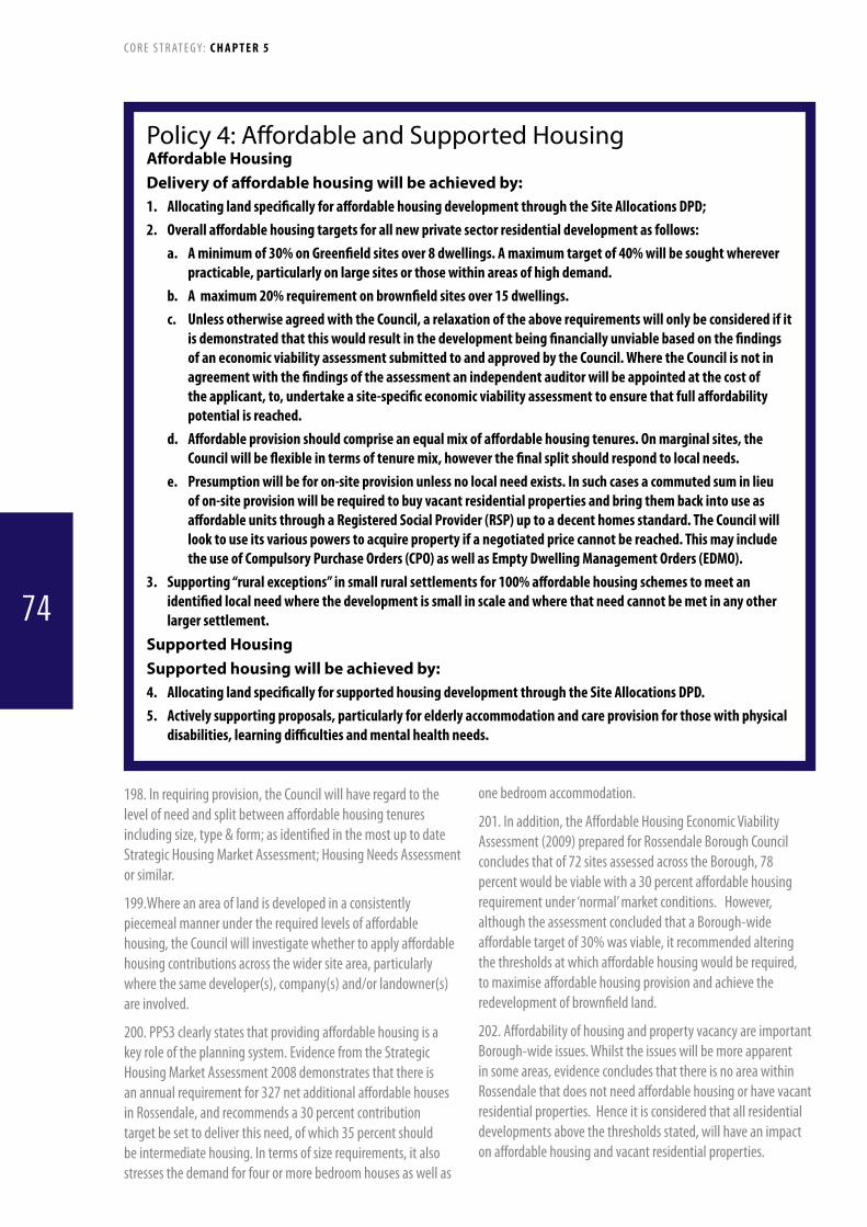
Policy 4: Affordable and Supported HousingAffordable HousingDelivery of affordable housing will be achieved by:1. AllocatinglandspecificallyforaffordablehousingdevelopmentthroughtheSiteAllocationsDPD;2. Overallaffordablehousingtargetsforallnewprivatesectorresidentialdevelopmentasfollows:
a. Aminimumof30%onGreenfieldsitesover8dwellings.Amaximumtargetof40%willbesoughtwhereverpracticable,particularlyonlargesitesorthosewithinareasofhighdemand.
b. Amaximum20%requirementonbrownfieldsitesover15dwellings.c. UnlessotherwiseagreedwiththeCouncil,arelaxationoftheaboverequirementswillonlybeconsideredifit
isdemonstratedthatthiswouldresultinthedevelopmentbeingfinanciallyunviablebasedonthefindingsofaneconomicviabilityassessmentsubmittedtoandapprovedbytheCouncil.WheretheCouncilisnotinagreementwiththefindingsoftheassessmentanindependentauditorwillbeappointedatthecostoftheapplicant,to,undertakeasite-specificeconomicviabilityassessmenttoensurethatfullaffordabilitypotentialisreached.
d. Affordableprovisionshouldcompriseanequalmixofaffordablehousingtenures.Onmarginalsites,theCouncilwillbeflexibleintermsoftenuremix,howeverthefinalsplitshouldrespondtolocalneeds.
e. Presumptionwillbeforon-siteprovisionunlessnolocalneedexists.Insuchcasesacommutedsuminlieuofon-siteprovisionwillberequiredtobuyvacantresidentialpropertiesandbringthembackintouseasaffordableunitsthroughaRegisteredSocialProvider(RSP)uptoadecenthomesstandard.TheCouncilwilllooktouseitsvariouspowerstoacquirepropertyifanegotiatedpricecannotbereached.ThismayincludetheuseofCompulsoryPurchaseOrders(CPO)aswellasEmptyDwellingManagementOrders(EDMO).
3. Supporting“ruralexceptions”insmallruralsettlementsfor100%affordablehousingschemestomeetanidentifiedlocalneedwherethedevelopmentissmallinscaleandwherethatneedcannotbemetinanyotherlargersettlement.
Supported HousingSupported housing will be achieved by:4. AllocatinglandspecificallyforsupportedhousingdevelopmentthroughtheSiteAllocationsDPD.5. Activelysupportingproposals,particularlyforelderlyaccommodationandcareprovisionforthosewithphysical
disabilities,learningdifficultiesandmentalhealthneeds.
198. In requiring provision, the Council will have regard to the level of need and split between affordable housing tenures includingsize,type&form;asidentifiedinthemostuptodateStrategicHousingMarketAssessment;HousingNeedsAssessmentor similar.
199.Where an area of land is developed in a consistently piecemeal manner under the required levels of affordable housing, the Council will investigate whether to apply affordable housing contributions across the wider site area, particularly where the same developer(s), company(s) and/or landowner(s) are involved.
200. PPS3 clearly states that providing affordable housing is a key role of the planning system. Evidence from the Strategic Housing Market Assessment 2008 demonstrates that there is an annual requirement for 327 net additional affordable houses in Rossendale, and recommends a 30 percent contribution target be set to deliver this need, of which 35 percent should be intermediate housing. In terms of size requirements, it also stresses the demand for four or more bedroom houses as well as
one bedroom accommodation.
201. In addition, the Affordable Housing Economic Viability Assessment (2009) prepared for Rossendale Borough Council concludes that of 72 sites assessed across the Borough, 78 percent would be viable with a 30 percent affordable housing requirement under ‘normal’ market conditions. However, although the assessment concluded that a Borough-wide affordable target of 30% was viable, it recommended altering the thresholds at which affordable housing would be required, to maximise affordable housing provision and achieve the redevelopment of brownfield land.
202. Affordability of housing and property vacancy are important Borough-wide issues. Whilst the issues will be more apparent in some areas, evidence concludes that there is no area within Rossendale that does not need affordable housing or have vacant residential properties. Hence it is considered that all residential developments above the thresholds stated, will have an impact on affordable housing and vacant residential properties.
C O R E S T R AT E G Y: C H A P T E R 5
74

203. Thus the approach to securing affordable housing through the methods stated is considered to be in accordance with the principles and provisions of Circular 05/05 and The Community Infrastructure Levy Regulations 2010.
204. Whilst there is an acute affordable housing need in Rossendale, the Strategic Housing Market Assessment (2008) also concludes that there is a large need for supported housing, particularly in terms of suitable and appropriate accommodation for the elderly and those households with specific needs, such as limiting long-term illness.
205. Supported housing or ‘housing related support’ is available to people with a wide range of support needs, for example:
• peoplewithphysicaldisabilities• olderpeoplewithextracareneedsandthosewhoneedsupport
to manage their own homes • peoplewithmentalhealthneeds• peoplewithlearningdisabilities• youngpeopleleavingcareandthosewantingtolive
independently • peoplewithalcoholand/orsubstancemisuseproblems• peoplefleeingdomesticviolence• homelesspeopleintemporaryaccommodation
206. The location of affordable and supported housing will take into account potential impacts on sites of nature conservation value.
Policy Target Trigger Indicator Contingencies
4 25 affordable units to be delivered annually over the plan period to 2026
Less than 80% of 3 year target (90) delivered over a rolling 3 year period75% applications refused due to affordable housing provision over 12 months
Completions of affordable unitsApplications refused due (wholly or in part) to not providing affordable housing in accordance with Policy 4
Identify the problem and barriers/causes to development via discussions and/or assessment(s)Negotiate phasing of delivery of affordable housing on site by site basisWork with key partners, including Rossendale BC, to access funding, resources to increase deliveryReassess tenure mix on site by site basisReassess percentage requirementConsider a review of the Policy
4 5 empty properties to be brought back into use as affordable housing annually over the plan period up to 2026
Fewer than 9 properties brought back into use as affordable housing over three year rolling period.
Monitoring of empty properties brought back into use.
Identify the problem and barriers/causes to development via discussions and/or assessment(s)Liaise with owners, Registered Social Providers and internal Council departments to facilitate takeovers and identify suitable properties to bring back into use within the next 2-3 years.Consider a review of the Policy
Policy 5: Meeting the Needs of Gypsies, Travellers and Travelling ShowpeopleSufficient housing provision must be made to meet the needs of the whole community.It is proposed that:1. Upto5Permanentpitchesandupto3transitpitchesareprovided.2. ThepreferredareasofsearchareHaslingden,Waterfoot,StacksteadsandBacup.3. SiteswillbelocatedinplacesthathaveaccesstotheroadnetworkwhichisacceptabletotheHighwayAuthority,
bewithinreachofschools,shopsandotherfacilities,shouldhaveadequatespaceforbusinessandstorageactivitiesonsiteornearbyandhavereasonableaccessbyfoot,cycleorpublictransport.
4. Sitesshouldbelocatedwheretheyarecapableofbeingservedbyadequatewaterandwasteinfrastructureservices.
5. Allsitesshouldbewelllandscaped,becloseto“greeninfrastructure”networksandtakeintoaccountimpactonlocalresidentsincludingnoiseandlightpollution.
C O R E S T R AT E G Y: C H A P T E R 5
75
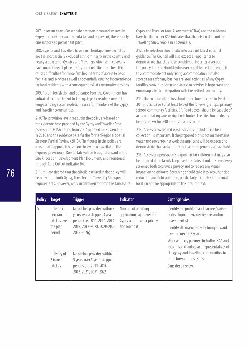
207. In recent years, Rossendale has seen increased interest in Gypsy and Traveller accommodation and at present, there is only one authorised permanent pitch.
208. Gypsies and Travellers have a rich heritage, however they are the most socially excluded ethnic minority in the country and nearly a quarter of Gypsies and Travellers who live in caravans have no authorised place to stay and raise their families. This causes difficulties for those families in terms of access to basic facilities and services as well as potentially causing inconvenience for local residents with a consequent risk of community tensions.
209. Recent legislation and guidance from the Government has indicated a commitment to taking steps to resolve some of the long-standing accommodation issues for members of the Gypsy and Traveller communities.
210. The provision levels set out in the policy are based on the evidence base provided by the Gypsy and Traveller Area Assessment GTAA dating from 2007 updated for Rossendale in 2010 and the evidence base for the former Regional Spatial Strategy Partial Review (2010). The figures in the policy are a pragmatic approach based on the evidence available. The required provision in Rossendale will be brought forward in the SiteAllocationsDevelopmentPlanDocument,andmonitoredthrough Core Output indicator H4.
211. It is considered that the criteria outlined in the policy will be relevant to both Gypsy, Traveller and Travelling Showpeople requirements. However, work undertaken for both the Lancashire
Gypsy and Traveller Area Assessment (GTAA) and the evidence base for the former RSS indicates that there is no demand for Travelling Showpeople in Rossendale.
212. Site selection should take into account latest national guidance. The Council will also expect all applicants to demonstrate that they have considered the criteria set out in the policy. The site should, wherever possible, be large enough to accommodate not only living accommodation but also storage areas for any business related activities. Many Gypsy families contain children and access to services is important and encourages better integration with the settled community.
213. The location of pitches should therefore be close to (within 30 minutes travel) of at least two of the following: shops, primary school, community facilities, GP. Road access should be capable of accommodating vans or rigid axle lorries. The site should ideally be located within 800 metres of a bus route.
214. Access to water and waste services (including rubbish collection) is important. If the proposed plot is not on the mains water and sewerage network the applicant will be expected to demonstrate that suitable alternative arrangements are available.
215. Access to open space is important for children and may also be required if the family keep livestock. Sites should be sensitively screened both to provide privacy and to reduce any visual impact on neighbours. Screening should take into account noise reduction and light pollution, particularly if the site is in a rural location and be appropriate to the local context.
Policy Target Trigger Indicator Contingencies
5 Deliver5permanent pitches over the plan period
No pitches provided within 3 years over a stepped 3 year period (i.e. 2011-2014, 2014-2017, 2017-2020, 2020-2023, 2023-2026)
Number of planning applications approved for Gypsy and Traveller pitches and built out
Identify the problem and barriers/causes to development via discussions and/or assessment(s)Identify alternative sites to bring forward over the next 2-3 yearsWork with key partners including HCA and recognised charities and representatives of the gypsy and travelling communities to bring forward those sitesConsider a review.
Deliveryof3 transit pitches
No pitches provided within 5 years over 5 years stepped periods (i.e. 2011-2016, 2016-2021, 2021-2026)
C O R E S T R AT E G Y: C H A P T E R 5
76

Policy 6: Training and skills
Thefollowingapproachwillbetakentowardimprovingandprovidingnewopportunitiesfortrainingandskills:• TheCouncilwillworkcloselywithpublic,privateandvoluntarysectorpartnerstomaximiseaccesstotraining
andworkopportunitiesforthosewantingtoenterthelabourmarketorseekingtoupgradeexistingskillsincludingthroughthenegotiationofLocalEmploymentChartersaspartoftheplanningapplicationprocess.Theenhancementofeducationalandtrainingfacilitiesincludingplansforafacilityfor14-21yearoldsintheBacuparea will be actively supported
• TheCouncilwillparticularlyseektomaximisetrainingopportunitiesforresidentslivinginthemoredeprivedpartsoftheBorough
• TheCouncilwillseektonegotiate,whereappropriate,trainingagreementsandothermeasureswithemployersto ensure that new development contributes to raising skills levels within the Borough and increasing the numberoflocalpeopleinemployment
• Trainingopportunitiesinallsectorsoftheeconomywillbeencouragedbutwithparticularemphasisonthefollowingsectors:• ICTandspecialistengineering• Tourismandleisure• Renewableenergyengineering,manufactureandinstallation• Traditionalskills
216. Rossendale has a number of wards with concentrations of low educational attainment (worst 20% nationally). This includes the centre of Haslingden, the eastern end of Stacksteads, parts of Bacup and the Hall Carr area of Rawtenstall. High levels of benefit dependency, restrictions in employment to low pay/low skill jobs and broader social and environmental problems lead directly from this. Efforts to enhance access to skills and training will be focussed on benefitting the areas of the Borough and individuals most in need.
217. Providing opportunities for enhanced education and training is essential to improving residents’ quality of life and providing a skilled workforce for local employers. The Council will work with employers to encourage employment and training of local staff, including in the construction sector. Local Employment Charters will be used as a mechanism to achieve this including through the planning conditions and section 106 agreements.
218. Construction of a new sixth form college at Alder Grange School is projected to be completed in 2011 with enhancements to the facilities of other secondary schools in the Borough expectedinthenextfiveyears.Developmentwilloccurwithinthe existing school curtilages and will be expected to respect the built and environmental character of the site.
219. Further and Higher Education opportunities are currently limited with students on vocational courses such as NVQ’s currently having to travel outside the Borough. This reduces uptake of such courses, especially in the east of Rossendale. A partnership of Lancashire County Council, local secondary schools, Accrington and Rossendale College, Rossendale Borough
Council,LancashireCountyDevelopmentsLtdandotherbodiesare seeking to develop a major new facility near Bacup. Targeted at the 14-21 age group it will specifically address training issues for sectors such as construction, catering and health. It is hoped that this will significantly enhance educational uptake and reduce deprivation in the Borough.
220. Training and Skills development will be encouraged across all sectors of the economy including the construction and retail trades. Reviving and enhancing traditional skills such as stonemasons and blacksmiths would help reinforce local distinctiveness. Particular focus will be paid to diversifying the economy and raising local wage levels, e.g. in the ICT and specialised engineering sectors. The growth of renewable technologies offers the opportunity for enhancing skills to operate in this sector. The tourism sector (including hospitality) offers a range of jobs and the Council would want to support training that will enable growth in this sector.
C O R E S T R AT E G Y: C H A P T E R 5
77
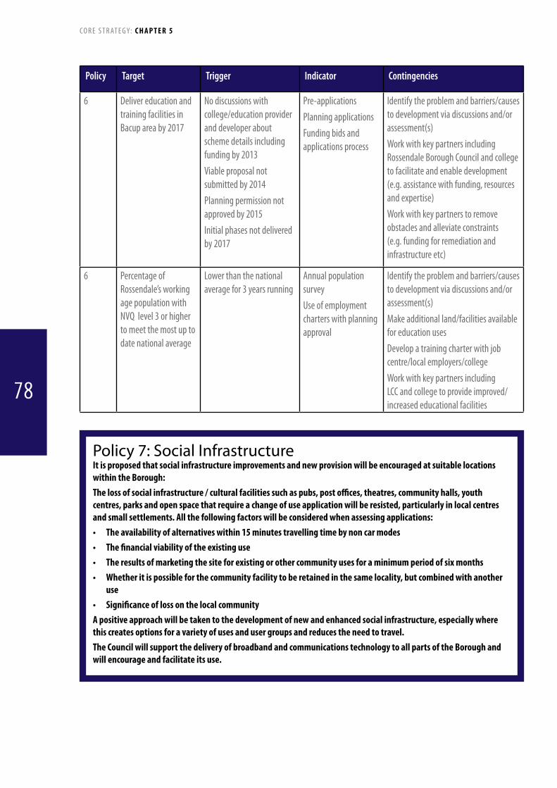
Policy Target Trigger Indicator Contingencies
6 Delivereducationandtraining facilities in Bacup area by 2017
No discussions with college/education provider and developer about scheme details including funding by 2013Viable proposal not submitted by 2014Planning permission not approved by 2015Initial phases not delivered by 2017
Pre-applicationsPlanning applicationsFunding bids and applications process
Identify the problem and barriers/causes to development via discussions and/or assessment(s)Work with key partners including Rossendale Borough Council and college to facilitate and enable development (e.g. assistance with funding, resources and expertise)Work with key partners to remove obstacles and alleviate constraints (e.g. funding for remediation and infrastructure etc)
6 Percentage of Rossendale’s working age population with NVQ level 3 or higher to meet the most up to date national average
Lower than the national average for 3 years running
Annual population surveyUse of employment charters with planning approval
Identify the problem and barriers/causes to development via discussions and/or assessment(s)Make additional land/facilities available for education usesDevelopatrainingcharterwithjobcentre/local employers/collegeWork with key partners including LCC and college to provide improved/increased educational facilities
Policy 7: Social InfrastructureItisproposedthatsocialinfrastructureimprovementsandnewprovisionwillbeencouragedatsuitablelocationswithintheBorough:Thelossofsocialinfrastructure/culturalfacilitiessuchaspubs,postoffices,theatres,communityhalls,youthcentres,parksandopenspacethatrequireachangeofuseapplicationwillberesisted,particularlyinlocalcentresandsmallsettlements.Allthefollowingfactorswillbeconsideredwhenassessingapplications:• Theavailabilityofalternativeswithin15minutestravellingtimebynoncarmodes• Thefinancialviabilityoftheexistinguse• Theresultsofmarketingthesiteforexistingorothercommunityusesforaminimumperiodofsixmonths• Whetheritispossibleforthecommunityfacilitytoberetainedinthesamelocality,butcombinedwithanother
use• SignificanceoflossonthelocalcommunityApositiveapproachwillbetakentothedevelopmentofnewandenhancedsocialinfrastructure,especiallywherethiscreatesoptionsforavarietyofusesandusergroupsandreducestheneedtotravel.TheCouncilwillsupportthedeliveryofbroadbandandcommunicationstechnologytoallpartsoftheBoroughandwillencourageandfacilitateitsuse.
C O R E S T R AT E G Y: C H A P T E R 5
78

221. The last decade has witnessed a significant decline in the number of pubs and post offices in Rossendale. This is primarily the result of changing economics, increased use of the internet and the dominant role of supermarkets. The “Spatial Planning in Lancashire: Annual Monitoring Report 2” (Lancashire County Council 2009) indicates that the percentage of the population in Rossendale with access to five basic services within 1km (food shop, GP, primary school, post office and bus stop) has declined from 59.4% in 2003/04 to 46.2% in 2007/08. Within Lancashire only Ribble Valley has a lower level of service access. This is primarily due to closure of Post Offices and consolidation of health facilities in Rawtenstall and Bacup as well as the linear nature of the settlements. Places such as Edenfield, Helmshore, Stacksteads, Water and Weir all perform poorly against these criteria.
222. Leisure facilities in the Borough are also being consolidated. This will result in improved swimming pools being constructed in Haslingden and Marl Pits, Rawtenstall. The latter will also include a new outdoor football/netball area. Equipment in parks and play areas will be progressively improved in line with priorities set out in the Council’s Open Space Strategy and a long-term programme set in place to enhance the Borough’s principal parks to “Green Flag” standard. Open Space issues are also addressed in Policy 17.
223. The planning system is limited in its ability to prevent closures but can through the planning application process require applicants to demonstrate that all reasonable measures have been taken to reuse the building for its previous use. Working both within the Council and with partners, opportunities for business support and grants will be examined. Where closure and/or a change of use is proposed applicants will be expected to demonstrate that the existing use is not viable and that a thorough marketing exercise has been undertaken to try and retain a community use of the building. This should include targeted advertising through estate agents and newspapers and inviting expressions of interest from community groups.
224. Over 700 voluntary and community groups exist in Rossendale providing a wide range of services through facilities such as the Maden Centre in Bacup. Other providers such as the Health Trusts, Lancashire County Council and the Borough Council also have an essential role. The development of new facilities will be supported through the planning process, and work with partners both for standalone schemes or as part of larger developments. The Council is particularly keen to encourage social infrastructure that can be used by a range of different users or groups.
Policy Target Trigger Indicator Contingencies
7 90% of resident population and business with access to next generation broadband by 2026
75% or less of resident population and business with access to next generation broadband in 2016
Pennine Lancashire StudyRegenerate Pennine LancashireInfrastructure Study
Identify the problem and barriers/causes to development via discussions and/or assessment(s)Engage with providers to encourage and attract investment
No more than 15% decline in access to 5 basic services e.g. GP’s etc from 07/08 levels over the plan period to 2026
5% or more decline of each over 5 year periods (2011-2016, 2016-2021, 2021-26)
Access to services indicator - LCCApplication of impact assessment to assess significance of impact of loss
Identify the problem and barriers/causes to development via discussions and/or assessment(s)Work with key partners including local communities to provide facilities and resources for local services
C O R E S T R AT E G Y: C H A P T E R 5
79

Policy 8: Transport proposals including Rawtenstall-Manchester Railway linkIt is proposed that transport improvements and provision within Rossendale will be achieved as set out below:RAWTENSTALL-MANCHESTER RAILWAy The East Lancashire Railway corridor from Rawtenstall to the Borough boundary will be safeguarded for combined use as a commuter and heritage railway operation with land in the vicinity of Ewood Bridge to be investigated as a “Park and Ride” site. Pedestrian links from Rawtenstall Railway Station to the town centre will be enhanced.BUSESWorking in conjunction with key partners such as Lancashire County Council and the bus operators the following measures will be pursued to enhance the road based public transport network:• DevelopmentofanewbusstationinRawtenstalltowncentre• Introductionofbusprioritymeasuresatkeycongestionlocationsandimprovement
of bus stops • BusParkandRidefacilitiesinRawtenstallROADSThe Council will work with the Highway Authority to reduce congestion at key locations within the Borough, such as the gyratory in Rawtenstall, the Tesco roundabout at Haslingden, Stacksteads and the Waterfoot area. It will also work with the Highways Agency to pursue the most effective management of the A56/M66 corridor for all users PARkINGCar parking standards including provision for the mobility impaired and cycles are included as an appendix to this document. Working with partners, car parking management in Rawtenstall, Bacup and Haslingden town centres and other locations will be undertaken as part of an overall policy of maintaining business vitality, integrated transport access and creation of attractive places. In older residential and business areas with specific local parking problems a range of measures will be supported, including new off-street provision where this does not cause environmental or highway issues.
225. 47% of the Borough’s workforce commutes to employment outside the Borough. There are significant flows to Burnley and Hyndburn. The 2001 census showed over 8 000 people travel to work in Greater Manchester while in excess of 3 000 travel in the opposite direction. Peak hour congestion on the M66 is an increasing problem which causes problems not only for car drivers but also for passengers on the Transdev X40/X41/X43 and X44 buses and for movement of goods.
226. The East Lancashire Railway is a key asset for the Borough. It currently operates a successful tourist service between Rawtenstall, Bury and Heywood (near Rochdale). It also has potential to perform an important role as a commuter service enabling a 35 minute journey from Rawtenstall to and from central Manchester. Implementation of this could significantly contribute to raising the profile of the Borough and assist
regeneration. Provision of “Park and Ride” facilities in the area of Ewood Bridge is of strategic importance to this proposal. Facilities will be needed in the vicinity of Rawtenstall station to encourage people to leave their cars while improved walking routes and bus interchange will also be pursued. These proposals will be subject to detailed consideration through the Site Allocations DPDandrelateddocuments.Appraisalofhowbesttodeliverthewhole scheme is being undertaken for a cross-border partnership of planning and transport authorities participating in the East Lancashire/West Rochdale Area Study (ELWRAS). This is being led by Transport for Greater Manchester. The earliest date of implementation is expected to be 2014/15 and will incorporate consideration of detailed design issues to ensure that the historic ambiance of the line and buildings is retained.
227. Bus services perform an essential role in the movement
C O R E S T R AT E G Y: C H A P T E R 5
80

of people. The present Bus Station facilities in Rawtenstall are outdated and unattractive for the public and Rossendale Transport. Lancashire County Council has previously consulted on development of a replacement facility. Redevelopment of the bus station will be considered as a part of the broader regeneration of the town centre including the Valley Centre and will be examined throughaMasterplanning/SPDexercisewhichisduetoreportbythe March 2011. Bus waiting facilities elsewhere in the Borough will be improved wherever opportunities exist.
228. Express services to Manchester suffer delays within and outside the Borough due to congestion. Bus priority measures will be examined as part of the ELWRAS Study and will be developed in association with Lancashire County Council and the Highways Agency. Options for bus based “Park and Ride” in and around Rawtenstall will also be appraised.
229. Traffic congestion in Rossendale is limited to peak hours and is most pronounced around the gyratory in Rawtenstall, from Crawshawbooth into Rawtenstall, Haslingden Tesco roundabout, in Waterfoot and Stacksteads. The Borough Council will continue to work with Lancashire County Council to examine ways to improve traffic flows including through Accessibility Planning
techniques. Working with the Highways Agency the Council will seek to ensure effective management of the A56/M66 corridor as one of the key gateways to the Borough. This will include looking at enhanced signage to key locations in the Borough and promoting enhanced reliability for car and bus travellers and freight.
230. Car parking issues are particularly pressing in the centres of Rawtenstall, Bacup and Haslingden but also affect smaller settlements such as Crawshawbooth. Parking should be managed to maximise short stay provision and to minimise impacts on neighbours. This may include provision of off-road parking in older areas with limited on-road opportunities. Specific consideration should be given to the needs of cyclists and disabled users. Car Parking Standards are based on the former adoptedRSSandJointLancashireStructurePlanStandards.When identifying parking levels for individual schemes applicants will be expected to demonstrate they have taken into account the accessibility of the site by all means of transport as well as existing parking conditions in the vicinity of the site. For larger proposals this will include consideration of parking levels through a Transport Assessment and Travel Plan in order to reduce impacts on the highway network.
Policy Target Trigger Indicator Contingencies
8 Re-open ELR as a commuter line between Manchester and Rawtenstall by the end of the planning period - 2026
Initial Binding agreement with ELR, Transport for Greater Manchester and other relevant partners not in place by 2014Initial funding and phasing of pilot shuttle services not implemented by 2016No committed funding for full schemeCapacity and quality increases and improvements of service not in place by 2026
Progress with funding agreementProgress with funding and technical workNumber of services and patronageFrequency and speed of services
Identify the problem and barriers/causes to development via discussions and/or assessment(s) Interim Implementation –phase delivery of schemePhase delivery of residential development in and around Rawtenstall to increase patronageWork with partners to overcome technical difficulties and alleviate constraints providing access to funding, resources and best practice.
8 New Bus Station to be operational by 2016
SchemenotidentifiedinLTP3DistrictImplementation Plan end 2011Funding not in place by 2013Planning application not submitted by 2014Planning application not approved by end of 2014Scheme not implemented by end of 2016
Progress on funding agreementsPlanning applications monitoringProgress on implementation
Identify the problem and barriers/causes to development via discussions and/or assessment(s)DialoguewithLCCtofacilitateandenable development
C O R E S T R AT E G Y: C H A P T E R 5
81

Policy 9: AccessibilityItisproposedthatthefollowingprinciplesbeappliedtoallnewdevelopmentwithinRossendale:• TheTransportUserHierarchywillformthebasisforconsiderationofallapplications.• NewdevelopmentwithintheurbanboundaryshouldbeconcentratedclosetomainpublictransportcorridorssuchasRisingBridge-Whitworthorwithin400metresofabusstopwithregularservices.Enhancedlinkstokeyservicesandemploymentopportunities,includinginadjacentBoroughs,suchasKingswayinRochdale,willbepursued.Supportinginnovativeschemesfor“demandresponsive”transportwillbepursuedforhardtoaccesslocations.Accessibilityplanningwillbeusedasatooltoidentifythemostappropriateformofresponse.
• Thedesignandimprovementofstreetsandthewiderurbanenvironmentasattractiveplacesforalluserswillbegivenhighpriority.
• Thefootpath,cyclewayandbridlewaynetworkincludingtheRossendaleWay,IrwellSculptureTrailandNationalCycleNetworkwillbedevelopedandenhancedinanintegratedmanneraspartofRossendale’s“GreenInfrastructure”andTourismStrategy.Measurestoencourageusebythemobilityimpairedandthoseexperiencinghealthissueswillbepromoted.
• TheCouncilwillpromotethedeliveryofitsservicesaswellasthoseofkeystakeholdersintheBorough,throughmeansthatwherepossibleavoidtheneedtotravel(e.g.web-basedservicesandlocalprovision)andthatcanbeimplementedinacost-efficientandeffectivemanner.
231. National policy on transport, e.g. in “Manual for Streets” (2007)andDfT“GuidanceonTransportAssessment”aswellas the Lancashire County Council document “Creating Civilised Streets” supports a transport user hierarchy. Rossendale Borough Council will reflect this in consideration of applications and policy documents in the following order of priority:
• Pedestriansandmobilityimpairedusers
• Cyclistsandequestrians
• EmergencyVehiclesandrefusecollection
• PublicTransport,motorcyclesandtaxis
• Freightmovement
• Privatecars
232. The hierarchy approach does not mean that the private cars are not important, rather that the impact of the proposal on users higher up the hierarchy is given consideration first and that the design of the scheme reflects this. This supports both sustainable travel and better designed places.
233. Some wards in Rossendale, in particular around Bacup and Stacksteads, have low car ownership rates. Locating new development close to good quality public transport links is important for ensuring that individuals have opportunities to access key services such as health, education and leisure. This equally applies to origins (new housing) as well as destinations. Main transport corridors are classed as those with at least a 15 minute frequency peak hour service while regular services should have at least a 30 minute peak hour frequency.
234. Traditional bus services operate most efficiently on routes with lots of users, such as Haslingden-Rawtenstall-Bacup.
Serving outlying housing estates is often unprofitable and a more flexible “demand responsive” approach is often most appropriate. Working with both Lancashire County Council and the voluntary sectors, innovative approaches will be encouraged. Accessibility planning techniques such as use of “Accession” computer software and Travel Planning can be used to identify areas with poor links to social infrastructure such as hospitals and schools and can help examine and tailor the most appropriate ways to address this. This work is undertaken by Lancashire County Council but the Council will also expect developers of large proposals requiring frequent public access (e.g. major health facilities) to undertake such work. The Council will work with Lancashire County Council and local businesses to enhance access by non-car means to employment concentrations such as Carrs Industrial Estate at Haslingden.
235. Streets and public places are important places not just for movement of traffic but also as places where people live, shop and play. A large number of older streets in the Borough are unadopted and in poor condition while other streets are car dominated. New development proposals and regeneration schemes will be assessed against their ability to deliver attractive streets and public places building on good practice in “Manual for Streets” and “Creating Civilised Streets”. Where new footpaths are proposed it is expected that these should provide attractive, direct, safe links and integrate well into the existing networks, including “Green Infrastructure” identified in Policy 17. Upgrading and better maintenance of existing infrastructure will also be encouraged.
236. Rossendale has the densest public rights of way network in Lancashire but much of it is in poor condition. The network has great potential for active tourism which has already been
C O R E S T R AT E G Y: C H A P T E R 5
82

demonstrated by initiatives such as the Mary Towneley Loop bridleway as well as providing physical and mental health benefits for local residents. Public footpaths and bridleways are an essential component of the Boroughs ‘Green Infrastructure’ resource and play an important role in linking the towns to the
Policy Target Trigger Indicator Contingencies
9 Minimum of 90% of new development, excluding domestic extensions or energy proposals, to be within 400m of a bus stop with regular services (at least 30 minute peak hour frequency)
Less than 80% of new development, excluding domestic extensions or energy proposals, approved within 400m of a bus stop with regular services, over a rolling 3 year period
Planning applications
Identify the problem and barriers/causes to development via discussions and/or assessment(s) DialoguewithLCCandbusoperatorstodiscussservice coverageDialoguewithapplicants/developerstodiscusslocations of proposalsDialoguewithdevelopersovercontributionstofund transport/accessibility improvements
nearby countryside. Working with partners’ emphasis will be on developing good quality urban and rural networks and ensuring that broader benefits, including for biodiversity, are retained . Cycle routes both on and off road will also be enhanced with a particular focus on the corridor between Rawtenstall and Bacup.
.
C O R E S T R AT E G Y: C H A P T E R 5
83

Policy 10: Provision for EmploymentTheCounciltogetherwithdevelopersandotherpartnerswillseektoprovidesufficientemploymentlandtomeettheBorough’srequirementof20.84hectaresforB1,B2andB8useclasses(i.e.forBusiness,GeneralIndustrialandStorageandDistribution)fortheperiodupto2026.TheCouncilwillcontinuetoencouragetheretentionandgrowthofitsindigenouscompanies,providingsupportandfacilitiesfornewsmallerscalehi-techandcreativeindustries,andencouragingbusinessstart-upsbysupporting‘incubatorunits’and‘move-onfacilities’(small,affordableunitsfornewbusinesses).EmploymentopportunitiesrelatedtoincreasingRossendale’stourismofferandenhancingitsvisitoreconomywillalsobesupportedwhereappropriateandsupportedbyotherpoliciesintheCoreStrategy.ItisexpectedthatnewsiteswillbeneededtomeetdemandintheRawtenstallareaandtheBacup,WaterfootandStacksteadsCorridor.ThisprovisionwillbemetthroughtheAllocationsDevelopmentPlanDocument,wheretheCouncilwillprotectthebestsitesintermsoftheirlocation,accessandsuitability.Newproposalsshouldprimarilybelocatedwithinthedefinedurbanboundaryandmaximisetheuseofpreviouslydevelopedlandandbuildings,meethighenergystandards,andbeaccessiblebymodesotherthantheprivatecar.InparticulartheCouncilwillseektoprotectandmakebestuseofkeyemploymentlocationsinRawtenstall(NewHallHey),Bacup(FuturesPark),Haslingden(CarrsIndustrialEstate)andRisingBridge.Renovationofolderindustrialestateswillbeencouragedtoimprovetheirattractiveness,andsupportwillbegiventoencouragere-useofmillbuildingsforemploymentpurposes,whereappropriate.Officedevelopment(B1andA2uses)shouldbeprimarilylocatedinoradjacenttothetowncentresofRawtenstall,BacupandHaslingden.Thelossofexistingemploymentsitesandbuildingstononemploymentgeneratinguseswillonlybesupportedwhere:(a)re-developmentforemploymentuseshasbeenadequatelydemonstratedtothesatisfactionoftheCounciltobe
economicallyunviableandthesiteisunlikelytobeusedforexistingorfutureemploymentpurposes,or(b)theaccesstothesiteispoorandcannotbeadequatelyimproved,or(c) thecurrent,oranyalternativeemployment,usehasasignificantadverseimpactontheneighbouringlanduses,
or(d)thesiteand/orbuildingsaresignificantheritageassetsandtheirre-useordevelopmentisthemostappropriate
meanstosecureandmaintainanacceptableandviableusethatisconsistentwiththeirconservation,and in all cases(e)thesitehasbeenmarketedfor12months,orlessinexceptionalcircumstances,usingamethodologyagreedby
theCouncil,and(f) thedevelopmentwillhavenounacceptableadverseimpactsonsurroundinglanduses.There-useandretentionofsuitablebuildings,includingthoseinruralareas,forappropriateemploymentgeneratinguseswillbesupportedwhere:• itassistsdiversificationoftheexistingemploymentbase,or• itsupportsthecreationorgrowthofalocalbusiness,or• itretainsbuildingsofsignificantarchitectural,historicorartisticinterest,or• itcontributestoawiderregenerationinitiative,andinallcases• Theproposalpromotestheenhancementoftheenvironmentandaccessibilityprovision,minimisestransport
impactsandmakesbestuseoftheexistingspaceTheCouncilwillingeneralsupportthecreationandexpansionofsmallbusinesseswithintheBorough,andpromoteflexiblestartupaccommodationintheformofsmallofficesandindustrialunitswithinthekeysettlementsofRawtenstall,BacupandHaslingden.‘Moveon’facilitieswillalsobeencouragedtosupporttheirgrowth,suchasatNewHallHey.Opportunitiesforhome-workingwillbeencouraged,whereappropriate.ProposalsforcreativeindustriesinWaterfootandBacupwillbegivenpositiveconsideration,inlinewiththispolicy.ThispolicyislinkedtoPolicy14,whichrecognisestheemploymentopportunitiesassociatedwithdevelopingthetourismsectorwithintheBorough,thatarenotwithinthetraditionalemploymentuseclassesofB1,B2andB8.
C O R E S T R AT E G Y: C H A P T E R 5
84
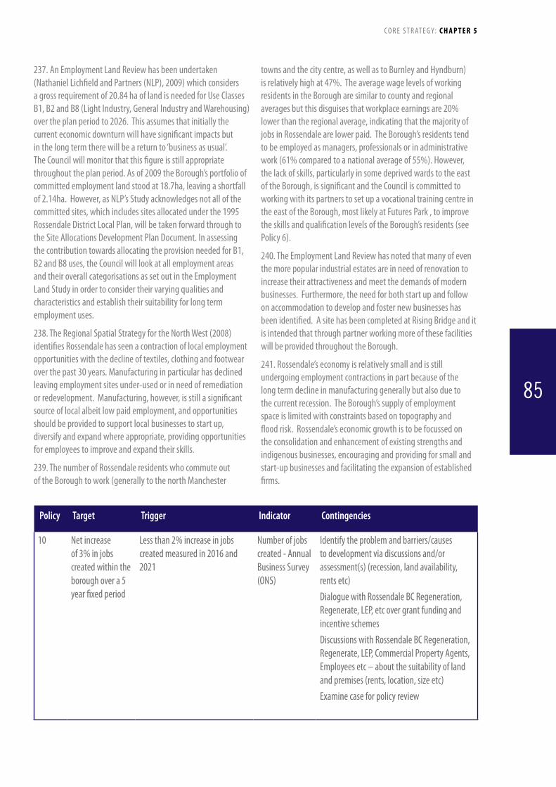
towns and the city centre, as well as to Burnley and Hyndburn) is relatively high at 47%. The average wage levels of working residents in the Borough are similar to county and regional averages but this disguises that workplace earnings are 20% lower than the regional average, indicating that the majority of jobs in Rossendale are lower paid. The Borough’s residents tend to be employed as managers, professionals or in administrative work (61% compared to a national average of 55%). However, the lack of skills, particularly in some deprived wards to the east of the Borough, is significant and the Council is committed to working with its partners to set up a vocational training centre in the east of the Borough, most likely at Futures Park , to improve the skills and qualification levels of the Borough’s residents (see Policy 6).
240. The Employment Land Review has noted that many of even the more popular industrial estates are in need of renovation to increase their attractiveness and meet the demands of modern businesses. Furthermore, the need for both start up and follow on accommodation to develop and foster new businesses has been identified. A site has been completed at Rising Bridge and it is intended that through partner working more of these facilities will be provided throughout the Borough.
241. Rossendale’s economy is relatively small and is still undergoing employment contractions in part because of the long term decline in manufacturing generally but also due to the current recession. The Borough’s supply of employment space is limited with constraints based on topography and flood risk. Rossendale’s economic growth is to be focussed on the consolidation and enhancement of existing strengths and indigenous businesses, encouraging and providing for small and start-up businesses and facilitating the expansion of established firms.
237. An Employment Land Review has been undertaken (Nathaniel Lichfield and Partners (NLP), 2009) which considers a gross requirement of 20.84 ha of land is needed for Use Classes B1, B2 and B8 (Light Industry, General Industry and Warehousing) over the plan period to 2026. This assumes that initially the current economic downturn will have significant impacts but in the long term there will be a return to ‘business as usual’. The Council will monitor that this figure is still appropriate throughout the plan period. As of 2009 the Borough’s portfolio of committed employment land stood at 18.7ha, leaving a shortfall of 2.14ha. However, as NLP’s Study acknowledges not all of the committed sites, which includes sites allocated under the 1995 RossendaleDistrictLocalPlan,willbetakenforwardthroughtotheSiteAllocationsDevelopmentPlanDocument.Inassessingthe contribution towards allocating the provision needed for B1, B2 and B8 uses, the Council will look at all employment areas and their overall categorisations as set out in the Employment Land Study in order to consider their varying qualities and characteristics and establish their suitability for long term employment uses.
238. The Regional Spatial Strategy for the North West (2008) identifies Rossendale has seen a contraction of local employment opportunities with the decline of textiles, clothing and footwear over the past 30 years. Manufacturing in particular has declined leaving employment sites under-used or in need of remediation or redevelopment. Manufacturing, however, is still a significant source of local albeit low paid employment, and opportunities should be provided to support local businesses to start up, diversify and expand where appropriate, providing opportunities for employees to improve and expand their skills.
239. The number of Rossendale residents who commute out of the Borough to work (generally to the north Manchester
Policy Target Trigger Indicator Contingencies
10 Net increase of 3% in jobs created within the borough over a 5 year fixed period
Less than 2% increase in jobs created measured in 2016 and 2021
Number of jobs created - Annual Business Survey (ONS)
Identify the problem and barriers/causes to development via discussions and/or assessment(s) (recession, land availability, rents etc)DialoguewithRossendaleBCRegeneration,Regenerate, LEP, etc over grant funding and incentive schemesDiscussionswithRossendaleBCRegeneration,Regenerate, LEP, Commercial Property Agents, Employees etc – about the suitability of land and premises (rents, location, size etc)Examine case for policy review
C O R E S T R AT E G Y: C H A P T E R 5
85
Policy Target Trigger Indicator Contingencies
10 No more than 30% loss of land currently classed as B1, B2 or B8 over the plan period (measured in ha).
Change from B use classes to other uses exceeding 5% over fixed 3 year period Greater than 5% loss of land in B use classes over consecutive fixed 3 year periods.
Monitoring planning application/approval by use classes order
Identify the problem and barriers/causes to development via discussions and/or assessment(s) (recession, land availability, rents etc)DialoguewithRossendaleBCRegeneration,Regenerate,LEP, etc over grant funding and incentive schemesDiscussionswithRossendaleBCRegeneration,Regenerate,LEP, Commercial Property Agents, Employees etc – about the suitability of land and premises (rents, location, size etc)Examine case for policy review
Policy 11: Retail and Other Town Centre Uses
Retaildevelopment,togetherwithothertowncentreuses,includingoffices,leisure,arts,cultureandtouristfacilities,willbefocusedwithinthedefinedtownandlocalcentres.Major proposals will be directed to Rawtenstall with other large schemes encouraged to locate in the district centres ofBacupandHaslingden.TheRetailhierarchyissetoutbelow: TownCentre: Rawtenstall DistrictCentres: Bacup,Haslingden LocalCentres: Waterfoot,Whitworth NeighbourhoodCentres: Allothercentres(includingEdenfield,Stacksteads,
Helmshore,Crawshawbooth)ThishierarchysupportstheCouncil’svisionofachievingaqualityretaildevelopmentattheValleyCentreinRawtenstall,withancillarylocalretailintheothercentres.Rawtenstallisalsothefocusformediumandlargescaleretailandleisuredevelopment.RetailproposalswillbedirectedtothePrimaryShoppingAreas(PSA).Proposalsfornon-retailusesappropriatetotowncentreswillbeconsideredfavourablywithinthetowncentreboundary,whichencompassesbutextendsbeyondthePSA.BoththePrimaryShoppingArea(PSA)andtownanddistrictcentreboundarieshavebeendefinedforRawtenstall,BacupandHaslingden.ForthesmallersettlementsofWaterfootandWhitworththelocalcentreboundaryisthesameasthePSA.Proposalsfornewconvenienceretailfloorspaceofgreaterthan200m²willberesistedoutsideofthedefinedPrimaryShoppingAreaboundariesunless:• underthesequentialtestamoreappropriatesitecannotbeidentified,or• itformspartofawiderCouncilendorsedregenerationscheme,andtheproposalwillimproveconsumerchoice
anddiversifyemploymentopportunities,orotheragreedbenefits,and• itcanbedemonstratedtotheCouncil’ssatisfactionthatitwillnothaveanunacceptableadverseimpactonthe
vitalityandviabilityofothercentres.Alldevelopments(convenienceandcomparison)willbeexpectedtoprovideImpactAssessmentswheretheyareabovethefollowingthresholds:• RawtenstallTownCentre–750m²• BacupandHaslingdenDistrictCentres–500m²• Elsewherewithintheborough–200m²
C O R E S T R AT E G Y: C H A P T E R 5
86

242. Rossendale’s centres should be the focus for new economic growth with main town centre uses developed in these centres. A wide range of services should be offered in the centres including retail, leisure, offices, tourism, arts and cultural facilities as well as special events. The vitality and viability of the towns will suffer if the main town centre uses are not focused within these centres, with the scale of development and services offered reflecting the Retail Hierarchy.
243. This hierarchy supports the Council’s vision of achieving quality, well designed, mainly higher order retail development at the Valley Centre. with only appropriate retail at New Hall Hey which cannot be accommodated in the Town Centre, such as bulky goods.
244. Rossendale’s Retail and Town Centre Study has noted that there is no global capacity for additional convenience floorspace in the Borough, given the number of superstores operating now in the Rawtenstall area. However, it is considered that the retail offer in Bacup could be improved with the addition of a new supermarket, and this is supported by the Council. There is some capacity for comparison shopping in Rossendale, taking into account the leakage expenditure going to neighbouring towns and this can be met in the centres, particularly in Rawtenstall, which can accommodate medium to large scale retail and leisure developments. The Borough has a strong representation of independent retailers, which is to be supported and encouraged.
245. The retail hierarchy recognises Rawtenstall’s role as the dominant centre in the Borough, providing retail facilities, services and civic functions to Rossendale’s residents. Bacup and Haslingden are also important, but serve smaller catchments.
246. The Council intends to partner developers in providing training opportunities and associated local jobs for people, as
Policy Target Trigger Indicator Contingencies
11 No greater than 20% of retail approvals (floorspace sq m) to be outside the defined primary shopping areas over plan period
More than 30% of approved retail floorspace outside of the defined PSA over consecutive 3 year rolling period.
Monitoring planning application/approvals for retail uses by location
Identify the problem and barriers/causes to development via discussions and/or assessment(s)Review of PSA boundariesDialoguewithcommercialpropertyagents/regeneration over rents and suitability of potential retail units within PSA’s
11 No more than 20% of development for office use (A2 and B1(a), measured by floorspace) to be located outside town centre boundaries of Rawtenstall, Haslingden and Bacup over plan period
More than 30% of approved office space located outside of town centre boundaries of Rawtenstall, Haslingden and Bacup over consecutive 3 year rolling period.
Monitoring planning application/approvals for office uses by location
Identify the problem and barriers/causes to development via discussions and/or assessment(s)Dialoguewithcommercialpropertyagents/regeneration over rents and suitability of potential retail units within PSA’sAppraise suitability/viability of sites with agents and developersReview town centre boundaries
discussed in Policy 6. Additional convenience choice may be expected at Bacup to improve the town’s offer. However, the number of supermarkets trading within the catchment area of Rawtenstall suggests that additional provision is unlikely to be supported within Rawtenstall.
247. It has been necessary to amend boundaries from those definedonthe1995RossendaleDistrictLocalPlantoallowthecontraction and consolidation of centres. This is to increase the viability and vitality of these centres, taking into account the high numbers of vacancies within the centres. Vacancy levels are high in all of the centres, greatly exceeding the current (2011) national average of 11.4%, and the range of different types of shops has alsodeclined.TheboundariesoftheTown/District/Localcentresand of the Primary Shopping Area have been defined to show the current concentration of land uses and to help the centres’ future health by consolidating retail and service uses on a smaller area, allowing peripheral areas to revert to other employment uses or residential, and improving the vitality and viability of the defined centre.
248. The key town centre, district centre and local centre boundaries have been re-defined in the context of PPS 4 and the health checks undertaken as part of the Retail and Town Centre Study (NLP, 2009). The Primary Shopping Area (PSA) has been defined for Rawtenstall, Bacup and Haslingden. This is the primary boundary for retail development, and is made up of primary shopping frontages and contiguous secondary frontages. The local centres of Waterfoot and Whitworth have also been redefined. As these centres do not have areas of predominantly leisure, business and other main town centre uses adjacent to the primary shopping area, the town centre does not extend beyond the PSA. No boundaries have been set for the smaller neighbourhood centres.
C O R E S T R AT E G Y: C H A P T E R 5
87

Ormero
d St
Bank S
t
Bank St
Bright St
Back Lane
Haslingden Old Rd
Grange Crescent
Bacup Rd
Lord St
Markross St
James St
Bacup Rd
Bocholt Way
Haslingden Rd
Bury
Rd
Bury
Rd
Mou
nt T
err
Henry St
St M
ary’
s Way
St M
ary’
s Way
Burnley Rd
Millgate Rd
Daisy Hill
Newchurch Rd
Whittle St
Grange Rd
North St Kay St
Annie St
PeterSt
Cape St
Grange St
RabySt
Millgate
South St
East Pd
Cran
ksha
w S
t
Hurst Ln
Higher M
ill St
Grange A
veA682
A682
A681
m
S
SA56
Primary Shopping Area Rawtenstall Market
Primary Shopping Frontage Out of Centre Supermarket
Secondary Shopping Frontage
Town Centre Boundary
Figure 19: Rawtenstall Town Centre Boundary
Map not to scale
m
S
m
S
C O R E S T R AT E G Y: C H A P T E R 5
Mapsareforillustrationpurposesonly.DetailedtowncentreboundariescanbeviewedintheRetailandTownCentreStudy2009
88

Yorkshire St
Todmorden Road
Burnley Rd
Daisy Bank
Rose Bank St
Fern St
Bankside Lane
Lord St
Goose Hill St
Lilly St
Rose Hill St
Rose St
Boston
Lane
Hea
d Ln
Hall St
Princess St
Dale St
Tower St
South St
Alma St
Inkerman St
Crimea St
Regent St
Industrial St
Thom
St
CentralView
Irwell Terrace
Union St
Lee St
Union St
Acorn St
The Dr
St James St
Austin St
King St
Mar
ket S
t
Rochdale Road
Gas St
Forge St
Foun
dry S
t
Bath St
Booth St
Alm
a St
Lum
b Sc
ar
Quarry St
A681
A671
A671
A671
Rd
m
Primary Shopping Area
Primary Shopping Frontage
Secondary Shopping Frontage
Town Centre Boundary
Figure 20: Bacup District Centre Boundary
Map not to scale
Bacup Marketm
S
C O R E S T R AT E G Y: C H A P T E R 5
Mapsareforillustrationpurposesonly.DetailedtowncentreboundariescanbeviewedintheRetailandTownCentreStudy2009
89
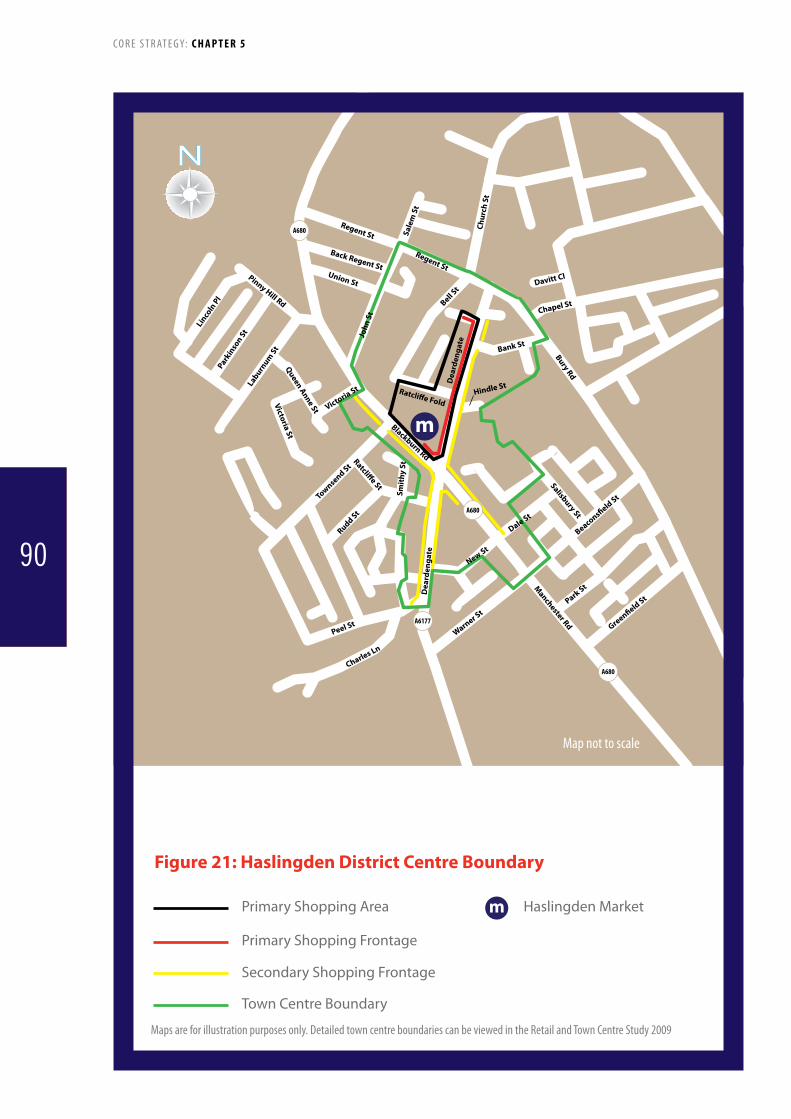
Regent St
Regent St
Sale
m S
t
John
St
Bell St
Chur
ch S
t
Bank St
Bury Rd
Chapel St
Davitt Cl
Hindle StRatcli�e Fold
New St
Dale St
Beacons�eld St
Park St
Green�eld St
Warner St
Dea
rden
gate
Dea
rden
gate
Salisbury St
Blackburn Rd
Manchester Rd
Ratcli�e StSm
ithy
St
Rudd St
Charles Ln
Peel St
Townsend St
Union StPinny Hill Rd
Queen Anne St
Victoria St
Back Regent St
Victoria StLaburn
um St
Parkin
son St
Linco
ln P
l
A680
A680
A680
A6177
m
Primary Shopping Area
Primary Shopping Frontage
Secondary Shopping Frontage
Town Centre Boundary
Figure 21: Haslingden District Centre Boundary
Map not to scale
Haslingden Marketm
S
C O R E S T R AT E G Y: C H A P T E R 5
Mapsareforillustrationpurposesonly.DetailedtowncentreboundariescanbeviewedintheRetailandTownCentreStudy2009
90
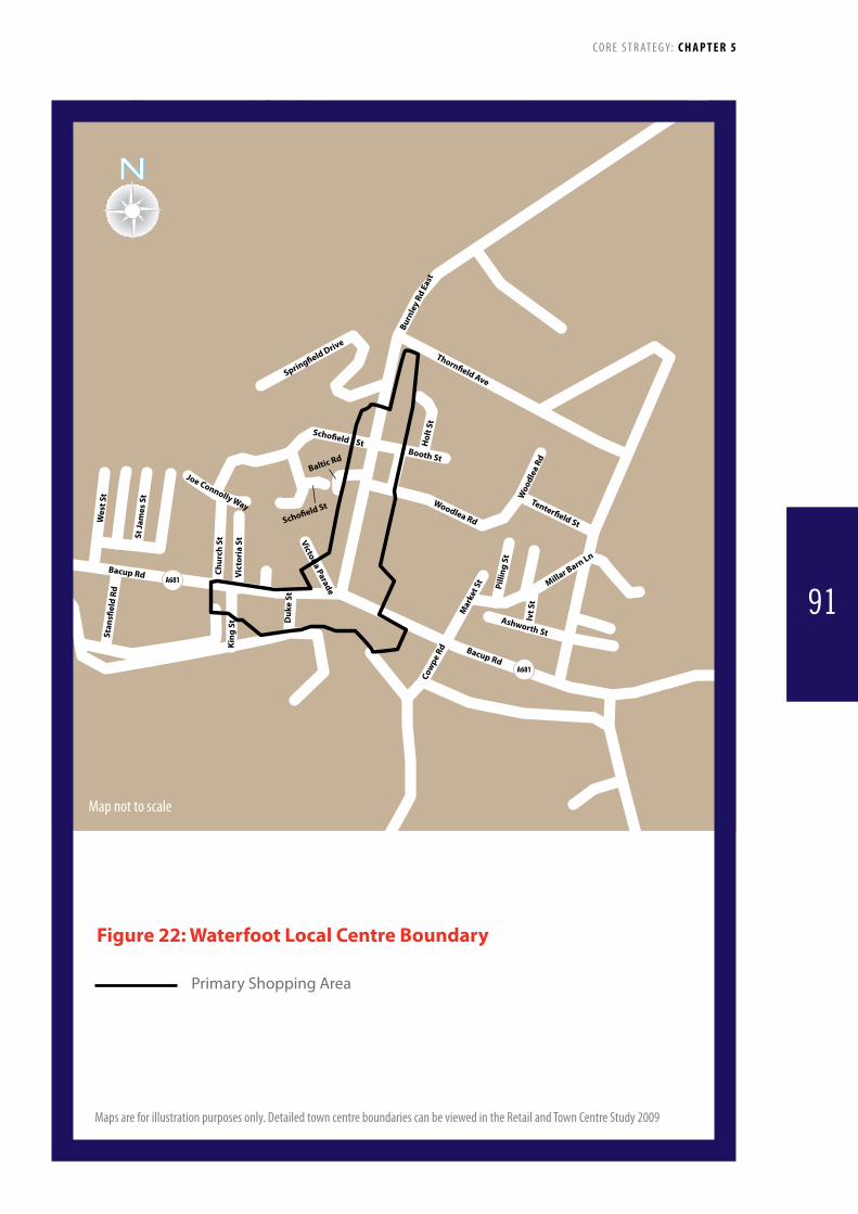
Daisy Bank
A671
Spring�eld Drive
A681
Joe Connolly Way
Thorn�eld Ave
Bacup Rd
Booth St
Scho�eld St
Woodlea Rd
Tenter�eld St
Victoria Parade
Duk
e St
Vict
oria
St
Chur
ch S
tSt Ja
mes
St
Wes
t St
Stan
s�el
d Rd
Bacup RdA681
Woo
dlea
Rd
Mar
ket S
t
Cow
pe R
d
Hol
t St
King
St
Burn
ley
Rd E
ast
Pilli
ng S
t
Ivt S
t
Ashworth St
Millar Barn Ln
Scho�eld St
Baltic Rd
Primary Shopping Area
Figure 22: Waterfoot Local Centre Boundary
Map not to scale
C O R E S T R AT E G Y: C H A P T E R 5
Mapsareforillustrationpurposesonly.DetailedtowncentreboundariescanbeviewedintheRetailandTownCentreStudy2009
91

Shed StRuth St
Middle St
North St
Brid
ge S
t
The Meadows
Lloyd St
William St
Hol
t St
Bayt
ree
Wal
k Mark
et St
Mar
ket S
t
Tong Lane
A671
Brenbar
Cre
scen
t
Cow
m P
ark
Way
Sou
th
Raw
stro
n St
Cowm
Par
k Way
Nort
h
Thorneylea
Mill St
Acre St
Primary Shopping Area
Figure 23: Whitworth Local Centre Boundary
Map not to scale
C O R E S T R AT E G Y: C H A P T E R 5
Mapsareforillustrationpurposesonly.DetailedtowncentreboundariescanbeviewedintheRetailandTownCentreStudy2009
92

Policy 12: The Valley Centre, Rawtenstall
ItisproposedthattheregenerationoftheValleyCentrewillbeachievedasfollows:TheregenerationoftheValleyCentreandadjacentbuildingsinRawtenstallisofstrategicimportance.Ahighqualitymasterplan-leddesignapproachisbeingdevelopedandwillincludethefollowingelements:• Afocalpointforretailerswithothersupportingotherusesappropriatetoatowncentre,• Designwhichrespondstotheexistingtownscapeinconcept,layoutanddesigndetailingandenhances
Rawtenstall’s urban grain• Streetmasterplanninganddesignwhichprovidesactivefrontages• AmixofusesthatencouragesnaturalsurveillanceandasafestreetenvironmentAlldesignsshouldtakeintoaccountpublictransportaccess,parkingprovisionandpublicopenspaceprovision.
249. The Valley Centre is a vacant shopping arcade that is currently semi-derelict and presents a negative image of the centre of Rawtenstall and the Borough as a whole. It is the Council’s top redevelopment priority reflecting strong public concern about the appearance of the structure. Rawtenstall, the only centre identified as a town centre within Rossendale, has a strong convenience goods offer and a good selection of independent shops. The Retail and Town Centre Study (2009) notes an absence of multiple retailers and suggests that the Valley Centre is a prime site that would be complementary to existing shops on Bank Street for improving the town’s overall retail offer and attractiveness.
250. The current building is a typical 1960’s design. Redevelopment of the shopping centre and other nearby buildings such as the Police Station and the One Stop Shop has the potential to significantly enhance the built environment and character of this area of Rawtenstall. (see Area Vision Policy AVP4)
251. It is envisaged that the redeveloped Valley Centre will incorporate a range of uses including retail, a public space and car parking with potential for other uses subject to viability. The re-development of the bus station (see Policy 8) as a separate project will enhance the southern gateway to the site.
252. The Council has achieved short term improvements to the site through a Section 215 notice under the Town and Country Planning Act 1990. It is negotiating with the current owners as well as other potential development partners to bring this site forward for mixed uses as quickly as possible. If a negotiated agreement cannot be achieved the Council may pursue a Compulsory Purchase Order. To facilitate progress consultants have been commissioned to prepare a Masterplan and viability assessmentforthesiteaspartofabroaderSPDforRawtenstallTown Centre.
Policy Target Trigger Indicator Contingencies
12 Redevelopment of the Valley Centre by 2016
Existing buildings not demolished by 2012Binding agreement with owner/developer, Rossendale BC, Lancashire County Council and other relevant partners on scheme details including funding not in place by 2013No submission of planning application by end of 2014Application not approved by 2015Works not commenced by 2016
Progress of demolitionProgress with binding agreementProgress with funding and scheme detailsProgress with planning application
Identify the problem and barriers/causes to development via discussions and/or assessment(s)Work with developers/landowners to facilitate and enable development (e.g. assistance with funding, resources and expertise)Work with developers and landowners to remove obstacles and alleviate constraints (e.g. alternative locations for businesses etc)Produce development brief for site aligned to planning application processJointventuredevelopmentpartnershipapproach
C O R E S T R AT E G Y: C H A P T E R 5
93

Policy 13: Protecting Key Local Retail and other ServicesItisproposedthatsmallerretailandotherservicecentreswillbesupportedandprotected.Theimportantroleofsmaller,independentshopswillbesupportedinalldefinedshoppingcentreswithschemestoenhanceand/orexpandsuchfacilitiesgivenpositiveconsideration.TheBoroughhasasupplyof‘cornershops’whichservelocalcommunities.Theseneedtobeprotectedtoavoidlongertripsbeingmadetoothercentres,whichhasimplicationsforinclusivity,aswellasreducingtheneedtotravel.WheretheCouncilconsidersthelossoftheretailfacilitymayhavenegativeimpactsforthelocalcommunity,itwillbenecessarytoprovideadditionalinformationandmarketthebuildingforaperiodofatleast12months,orlessinexceptionalcircumstances,usingamethodologyagreedbytheCouncil.TheexistingmarketsatBacup,HaslingdenandRawtenstallwillberetained.Considerationwillonlybegiventorelocationwhere:• thisformspartofawiderregenerationinitiativeand• itpositivelyre-enforcestheroleofthemarket
253. Independent shops are important in terms of the services and access to goods that they provide, as well as the jobs and investment they create. They also contribute to the distinct sense of place of the Borough’s settlements. Some outlets, such as top of the range clothes shops, attract a clientele from outside the Borough. Working with partners, the Council will seek to support local retailers through initiatives such as shopfront upgrading.
254. Many corner shops however operate on the margins of viability primarily because of the lower prices and wider range of goods offered by national retailers. The planning system is
limited in its ability to support these facilities but can require that changes of use are fully justified. These corner shops have an important function, particularly in the east of the Borough, providing employment and reducing the need to travel.
255. The Borough’s markets provide an important function but have been affected by the national decline in market use. The Council will continue to support markets including through improvements to the surroundings and related signage and capitalise on their tourism potential
Policy Target Trigger Indicator Contingencies
13 Retain 2008 levels of small convenience shops in neighbourhood centres
Greater than 15% loss of small convenience shops in neighbourhood centres over 5 year fixed period
Neighbourhood centre health check (Rossendale BC)
Identify the problem and barriers/causes to development via discussions and/or assessment(s)Work with shop owners to increase viability (business rates, incentives etc)Promote opportunities for appropriate mixed use developments in neighbourhood centresWork with Rossendale BC Regeneration to identify opportunities for redevelopment/consolidation of neighbourhood services
C O R E S T R AT E G Y: C H A P T E R 5
94
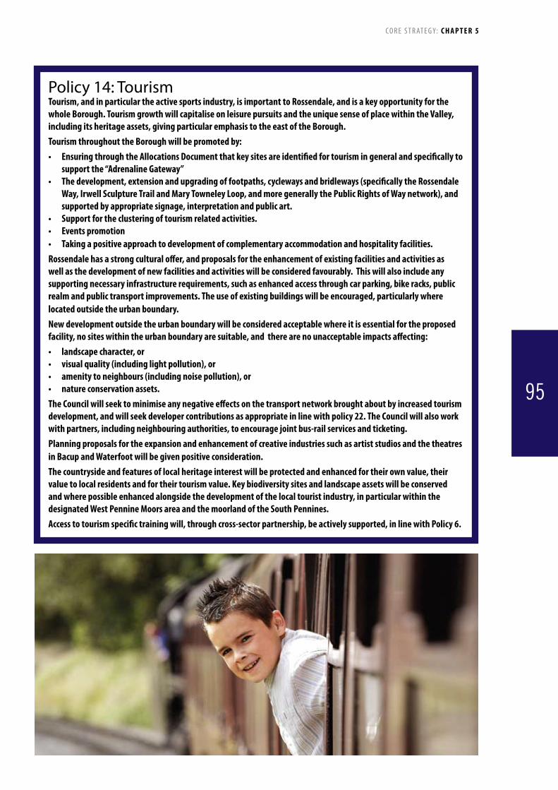
Policy 14: TourismTourism,andinparticulartheactivesportsindustry,isimportanttoRossendale,andisakeyopportunityforthewholeBorough.TourismgrowthwillcapitaliseonleisurepursuitsandtheuniquesenseofplacewithintheValley,includingitsheritageassets,givingparticularemphasistotheeastoftheBorough.TourismthroughouttheBoroughwillbepromotedby:• EnsuringthroughtheAllocationsDocumentthatkeysitesareidentifiedfortourismingeneralandspecificallyto
support the “Adrenaline Gateway”• Thedevelopment,extensionandupgradingoffootpaths,cyclewaysandbridleways(specificallytheRossendale
Way,IrwellSculptureTrailandMaryTowneleyLoop,andmoregenerallythePublicRightsofWaynetwork),andsupportedbyappropriatesignage,interpretationandpublicart.
• Supportfortheclusteringoftourismrelatedactivities.• Eventspromotion• Takingapositiveapproachtodevelopmentofcomplementaryaccommodationandhospitalityfacilities.Rossendalehasastrongculturaloffer,andproposalsfortheenhancementofexistingfacilitiesandactivitiesaswellasthedevelopmentofnewfacilitiesandactivitieswillbeconsideredfavourably.Thiswillalsoincludeanysupportingnecessaryinfrastructurerequirements,suchasenhancedaccessthroughcarparking,bikeracks,publicrealmandpublictransportimprovements.Theuseofexistingbuildingswillbeencouraged,particularlywherelocatedoutsidetheurbanboundary.Newdevelopmentoutsidetheurbanboundarywillbeconsideredacceptablewhereitisessentialfortheproposedfacility,nositeswithintheurbanboundaryaresuitable,andtherearenounacceptableimpactsaffecting:• landscapecharacter,or• visualquality(includinglightpollution),or• amenitytoneighbours(includingnoisepollution),or• natureconservationassets.TheCouncilwillseektominimiseanynegativeeffectsonthetransportnetworkbroughtaboutbyincreasedtourismdevelopment,andwillseekdevelopercontributionsasappropriateinlinewithpolicy22.TheCouncilwillalsoworkwithpartners,includingneighbouringauthorities,toencouragejointbus-railservicesandticketing.PlanningproposalsfortheexpansionandenhancementofcreativeindustriessuchasartiststudiosandthetheatresinBacupandWaterfootwillbegivenpositiveconsideration.Thecountrysideandfeaturesoflocalheritageinterestwillbeprotectedandenhancedfortheirownvalue,theirvaluetolocalresidentsandfortheirtourismvalue.Keybiodiversitysitesandlandscapeassetswillbeconservedandwherepossibleenhancedalongsidethedevelopmentofthelocaltouristindustry,inparticularwithinthedesignatedWestPennineMoorsareaandthemoorlandoftheSouthPennines.Accesstotourismspecifictrainingwill,throughcross-sectorpartnership,beactivelysupported,inlinewithPolicy6.
C O R E S T R AT E G Y: C H A P T E R 5
95
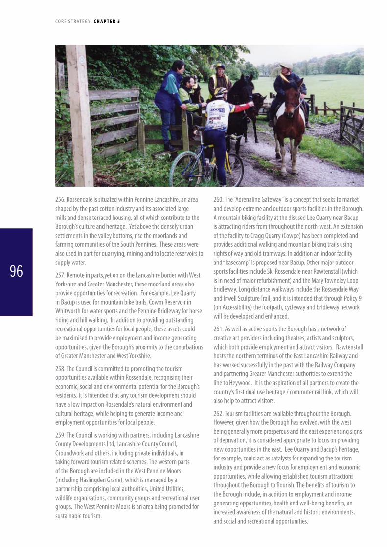
256. Rossendale is situated within Pennine Lancashire, an area shaped by the past cotton industry and its associated large mills and dense terraced housing, all of which contribute to the Borough’s culture and heritage. Yet above the densely urban settlements in the valley bottoms, rise the moorlands and farming communities of the South Pennines. These areas were also used in part for quarrying, mining and to locate reservoirs to supply water.
257. Remote in parts,yet on on the Lancashire border with West Yorkshire and Greater Manchester, these moorland areas also provide opportunities for recreation. For example, Lee Quarry in Bacup is used for mountain bike trails, Cowm Reservoir in Whitworth for water sports and the Pennine Bridleway for horse riding and hill walking. In addition to providing outstanding recreational opportunities for local people, these assets could be maximised to provide employment and income generating opportunities, given the Borough’s proximity to the conurbations of Greater Manchester and West Yorkshire.
258. The Council is committed to promoting the tourism opportunities available within Rossendale, recognising their economic, social and environmental potential for the Borough’s residents. It is intended that any tourism development should have a low impact on Rossendale’s natural environment and cultural heritage, while helping to generate income and employment opportunities for local people.
259. The Council is working with partners, including Lancashire CountyDevelopmentsLtd,LancashireCountyCouncil,Groundwork and others, including private individuals, in taking forward tourism related schemes. The western parts of the Borough are included in the West Pennine Moors (including Haslingden Grane), which is managed by a partnership comprising local authorities, United Utilities, wildlife organisations, community groups and recreational user groups. The West Pennine Moors is an area being promoted for sustainable tourism.
260. The “Adrenaline Gateway” is a concept that seeks to market and develop extreme and outdoor sports facilities in the Borough. A mountain biking facility at the disused Lee Quarry near Bacup is attracting riders from throughout the north-west. An extension of the facility to Cragg Quarry (Cowpe) has been completed and provides additional walking and mountain biking trails using rights of way and old tramways. In addition an indoor facility and “basecamp” is proposed near Bacup. Other major outdoor sports facilities include Ski Rossendale near Rawtenstall (which is in need of major refurbishment) and the Mary Towneley Loop bridleway. Long distance walkways include the Rossendale Way and Irwell Sculpture Trail, and it is intended that through Policy 9 (on Accessibility) the footpath, cycleway and bridleway network will be developed and enhanced.
261. As well as active sports the Borough has a network of creative art providers including theatres, artists and sculptors, which both provide employment and attract visitors. Rawtenstall hosts the northern terminus of the East Lancashire Railway and has worked successfully in the past with the Railway Company and partnering Greater Manchester authorities to extend the line to Heywood. It is the aspiration of all partners to create the country’s first dual use heritage / commuter rail link, which will also help to attract visitors.
262. Tourism facilities are available throughout the Borough. However, given how the Borough has evolved, with the west being generally more prosperous and the east experiencing signs of deprivation, it is considered appropriate to focus on providing new opportunities in the east. Lee Quarry and Bacup’s heritage, for example, could act as catalysts for expanding the tourism industry and provide a new focus for employment and economic opportunities, while allowing established tourism attractions throughout the Borough to flourish. The benefits of tourism to the Borough include, in addition to employment and income generating opportunities, health and well-being benefits, an increased awareness of the natural and historic environments, and social and recreational opportunities.
C O R E S T R AT E G Y: C H A P T E R 5
96

Policy Target Trigger Indicator Contingencies
14 Opening of Adrenaline Gateway ‘Basecamp’ facility by mid 2015
Viable location, scheme and funding not agreed by mid 2012Application not submitted by end of 2012Application not approved by mid 2013Scheme not started on site by mid 2014Scheme not operational by mid 2015
DeliveryoftheBaseCampFacility Identify the problem and barriers/causes to development via discussions and/or assessment(s)Explore alternative funding and locationWork with applicant on drawing up a suitable design/schemeDialoguewithdeveloperto overcome construction problems/delays
14 To increase patronage at key tourist destinations:Lee Quarry: 100% over plan periodEast Lancashire Railway: 100% over plan period
Less than 20% cumulative increase in patronage on ELR inperiods2011-2016;and less than 25% cumulative increase in periods 2016-2021 and 2021-2026Less than 60% cumulative increase in patronageby2016;lessthan 10% additional cumulative increase for periods 2016-2021 and 2021-2026
Number of tourist passenger journeys starting and/or finishing at Rawtenstall or Irwell Vale Number of users measured using cycle counters at 3 locations (Lee Quarry;BridlewaytoCragQuarryand Bridleway to Facit Quarry)
Identify the problem and barriers/causes to development via discussions and/or assessment(s)Discusswithpartners(ELR,LCCand other interested parties) about how to facilitate growthIdentify funding sources to introduce improvements to existing facilities
14 Percentage of jobs associated with tourism to increase over the Plan period from 7.2% (NOMIS ABIData,2008,based1527 jobs) to 10% over the plan period
No net increase or an actual decline in the % of tourism related jobs within the Borough, based on consecutive 3 year fixed periods
NOMIS Annual Business Inquiry data, based on Standard Industrial Classifications (SIC): 551 Hotels552 Camping / short stay provision553 Restaurants554 Bars633 Travel agents / tour operators925 Library, museum, cultural activities926 Sporting facilities927 Other recreational activities
Identify the problem and barriers/causes to development via discussions and/or assessment(s)Discusswithpartners,operators, employers, Regeneration and LCC Colleagues about how to create more jobs.Identify funding to bring forward jobs fasterLook at promotional literature and increased advertisingConsider review / update of Tourism Strategy
C O R E S T R AT E G Y: C H A P T E R 5
97

Policy 15: Overnight Visitor AccommodationTheCouncilwilltakeapositiveapproachtonew,small-scale,highqualityvisitoraccommodation.Thisincludeshotels,bedandbreakfastestablishments,self-cateringfacilities,bedandtack,campingbarns,andsitestobeusedforcampingandcaravanning.Proposalswillbesupportedparticularlywhereuseismadeofexistingbuildings.Proposalswillbesupportedatlocationsbothwithinandoutsideoftheurbanboundarywhere:· theyareappropriatetotheirlocality(includingintermsofsize,amenitytoneighbouringuses),and· theyarecomplementarytoexistingtourismfacilities,and· accessisgoodbyavarietyofmodes(withnoadverseeffectsonthelocalroadnetwork),and· thecapacityofexistinginfrastructureisadequate,and· therearenoharmfuleffectsonvisualamenity,landscape,ornatureconservationassets,and· thedevelopmentwillnotreducetheamountoflandinuseforthepurposesofopenspaceorrecreation,and· whereneedcanbedemonstrated.Inadditionforareasoutsidetheurbanboundaryitwillbeexpectedthat,whereitisappropriatetothetypeofestablishment(forexample,ahotel),usewillbemadeofexistingbuildings.Allancillaryfacilitiesshouldbedesigned(intermsofstyleandmaterials)totakeaccountoftheirfunctionsandblendintotheirsettings.Ancillaryfacilitiessuchascyclestorageorhorsepaddockswillbeencouragedinlocationssuchasalongbridlewaysorthecyclenetwork.Anylargescalehotelproposals(40bedroomsorover)shouldbelocatedinoradjacenttothetowncentresofRawtenstallorBacup.Outsideofthesecentres,largescalehotelproposalswillonlybesupportedwheretheyformpartofawiderregenerationscheme,candemonstrateawidercommunitybenefitandaccesstothesitecanbeprovidedbyavarietyofmodes.
263.JointworkisbeingundertakenwithadjoiningPennineLancashire authorities, which has also identified Rossendale as having one of the lowest numbers of overnight accommodation stays in the sub-region. As the tourism offer improves it is expected that the number of overnight stays will increase. Opportunities including bed and breakfast establishments, bed and tack along the bridleways, and camping and caravan sites will be encouraged. The intrinsic qualities that define Rossendale’s character should not be harmed, and where possible will be strengthened by these proposals.
264. Most new visitor accommodation is intended to be small scale (offering no more than 10 bed spaces or pitches) and could in many cases encourage the re-use of existing buildings. Caravan site proposals should be able to demonstrate good access arrangements and be well screened to minimise visual impact. Any new developments will be required to take appropriate steps to prevent any negative impacts on the landscape, heritage features (or their settings), biodiversity and sites of importance for nature conservation.
Policy Target Trigger Indicator Contingencies
15 At least one caravan site, one campsite and one bunkbarn delivered by 2016
Planning application not received for a caravan site, campsite and bunkbarn by start of 2014
Planning application monitoring
Identify the problem and barriers/causes to development via discussions and/or assessment(s)Identify suitable locations/developer interest forSiteAllocationsDPDDialoguewithRegeneration,RossendaleBorough Council, LCC, Lancashire & Blackpool Tourist Board, Regenerate, etc to promote/identify funding opportunities/scheme viabilityWork with developer to draw up suitable scheme
C O R E S T R AT E G Y: C H A P T E R 5
98

Policy 16: Preserving and Enhancing Rossendale’s Built EnvironmentThe Council will protect, conserve, preserve and enhance Rossendale’s historic built environment including Listed Buildings, Conservation Areas, Registered Parks and Gardens, Scheduled Ancient Monuments, archaeological sites, historic landscapes and locally identified buildings, sites and structures. These heritage assets all contribute to the local distinctiveness and character of the area. Their futures, including their settings will be safeguarded and secured by:1. Promoting the positive management of the Borough’s heritage assets, avoiding
unnecessary loss and requiring appropriate mitigation of any negative impacts.2. Extending the heritage protection for areas and/or buildings worthy of retention,
conservation and enhancement through the designation of appropriate additional Conservation Areas and Listing.
3. Enhancing the value of Rossendale’s historic built environment by carrying out Conservation Area Appraisals, implementing Conservation Area Management Plans and public access measures.
4. Protecting significant urban public realm (space) from development.5. Ensuring that all development is:
a. Located in a way that respects the distinctive quality of the historic landscape and setting and retains or enhances the character and context.
b. Of a high standard of design, reinforcing the local distinctiveness of Rossendale 6. Encouraging innovative new design(s), where it responds to the character, scale and
setting of historic buildings and areas.7. Maximising the potential for the re-use of buildings of historic or local interest
for appropriate uses to ensure their future longevity. However where this is not possible/appropriate, considerate and sensitive redevelopment will be supported, subject to advice from the Council’s Conservation Team and English Heritage.
8. The Council will support those schemes and proposals which contribute to conservation-led regeneration, particularly where they exploit the regeneration potential of the textile mill-towns and traditional architecture of rural villages within Rossendale.
265. Rossendale has a distinctive built environment, with many buildings and structures pre-dating the industrial revolution, constructed from locally quarried stone and which are important local assets.
266. Accordingly, all new development should be based on a thorough understanding of the context, significance and local distinctiveness of the site and its surroundings and should be of a high quality in terms of its urban, landscape and architectural design and use of materials.
267. There are nine Conservation Areas in Rossendale at various stages of re-appraisal including – Bacup Town Centre, Chatterton/Strongstry, Fallbarn, Goodshawfold, Higher Cloughfold, Irwell Vale, Loveclough Fold, Rawtenstall Town Centre and Whitworth Square. The Council will undertake appraisals of other areas to inform consideration and pursuit of additional Conservation Area designations. It is anticipated that by 2015 all designated conservation areas will have Conservation Area Appraisals and Management Plans.
C O R E S T R AT E G Y: C H A P T E R 5
99

Policy Target Trigger Indicator Contingencies
16 Conservation Area Appraisals for all conservation areas to be adopted by April 2012, and management plans adopted by April 2015
Conservation Area Appraisals not completed by October 2011Management Plans not completed by October 2014
DiscussionswithRossendaleBC Conservation Team on progress of appraisals and plans
Identify the problem and barriers/causes to development via discussions and/or assessment(s)Liaise with Rossendale BC Conservation Team, and provide assistance where appropriate
Policy 17: Rossendale’s Green InfrastructureTheCouncilwillpromotetheprotection,enhancementandwhereappropriatetheexpansionoftheGreenInfrastructurenetworkinthefollowingways:1. IdentificationandillustrationoftheGreenInfrastructurenetwork(seefigure23)2. PreparationofmoredetailedpoliciesthroughthefutureSiteAllocationsDPD,assistedbythedefinitionofkey
national,regionalandthemostsignificantlocalsitesontheProposalsMap.3. AspartoftheCouncil’sresponsetoclimatechange,newdevelopmentswillberequiredtomaximisethe
environmentalriskmanagementbenefitsofGreenInfrastructurewherepossiblethrough:a. Floodriskmanagement(utilisingSustainableDrainageSystems)b. Providingshade,coolingandcarbonstoragethroughtheplantingofappropriatevegetationandtreespeciesc. Contributingtoareductioninair,water,noiseandlightpollution.
4. ManageandappropriatelyenhanceexistingGreenBelt,openspaces,rivercorridors,urbangreencorridorsandwoodlands(asshownonfigure23)andcontinuetoprotectGreenlands(policyE.1asdesignatedintheRossendaleDistrictLocalPlan1995).WhereredevelopmenttakesplacetoenhanceGreenInfrastructure,theCouncilwillseektoensurethatwherenecessary,opportunitiesaretakentoaddressanyissuesoflandinstabilityorsurfacehazardsresultingfromhistoricminingactivity.
5. Resistthefragmentationofthenetworkbynewdevelopment,andpursuetheimplementationofNaturalEngland’sAccesstoNaturalGreenspaceStandards(ANGSt)overthelifetimeoftheCoreStrategy.
6. Expectnewdevelopmentstocontributetotheprovisionofrecreationalgreenspace,andtoincorporateimprovementstothequalityof,andaccessto,existingGreenInfrastructureinaccordancewithlocalcircumstances.
7. SupporttheimprovementofandaccesstothePublicRightsofWaynetwork(inparticularthePennineBridleway,RossendaleWay,IrwellSculptureTrail,ShoeTrailandNationalCycleRoutes)andotherlinearcorridorsinlinewithPolicy9andmaximisethepotentialofGreenInfrastructuretosupportsustainableandactivetourism,inconjunctionwiththeAdrenalineGatewayproject.
C O R E S T R AT E G Y: C H A P T E R 5
100

Ros
send
ale
Gre
en In
fras
truc
ture
Ty
polo
gies
01
Kilo
met
res
V:\H
EM\P
&I\N
HES
\Loc
al R
ecor
d C
entr
e\G
IS\A
rcM
apD
ocum
ents
\Par
tner
_Org
anis
atio
ns\R
osse
ndal
e G
I.mxd
- 15
Jul
y 20
10
This
map
is b
ased
upo
n O
rdna
nce
Surv
ey m
ater
ial
with
the
perm
issi
on o
f Ord
nanc
e Su
rvey
on
beha
lf of
the
cont
rolle
r of H
er M
ajes
ty’s
Sta
tione
ry O
ffice
©
Cro
wn
copy
right
. U
naut
horis
ed r
epro
duct
ion
infr
inge
s C
row
n co
pyrig
ht a
nd m
ay le
ad to
pro
secu
tion
or c
ivil
proc
eedi
ngs.
Lanc
ashi
re C
ount
y C
ounc
il 10
0023
320
2010
.
Allo
tmen
tsCe
met
erie
s, C
hurc
h Ya
rds,
Bu
rial G
roun
dsDe
relic
t Und
er U
tilise
d an
d Ne
glec
ted
Land
Ope
n Ac
cess
Out
door
Spo
rts F
acilit
ies
Park
s an
d Pu
blic
Gar
dens
Priva
te G
arde
nsVe
rges
of t
rans
port
corri
dors
Wat
erbo
dies
Woo
dlan
dRi
vers
Auth
ority
Bou
ndar
y
Figure 24 - Rossendale Green Infrastructure Map
C O R E S T R AT E G Y: C H A P T E R 5
101

268. Green Infrastructure is the Borough’s life support system – a multifunctional network of green spaces, corridors and waterways that lie within and between Rossendale’s towns and villages, often intertwined with distinctive features of industrial heritage - including the open countryside, the Green Belt, woodlands, agricultural land, parks, sports pitches, play areas, rivers, footpaths, gardens, allotments, along with many other formal and informal open spaces. Green Infrastructure provides multiple social, economic and environmental benefits and can support sustainable development whilst enhancing quality of life for residents and visitors alike. It also has an important role in providing habitats and migratory routes for many species of flora and fauna, as well as helping the Borough mitigate and adapt to climate change. The conservation and enhancement of our rich variety of Green Infrastructure, along with improving its accessibility, connectivity and potential to enhance people’s quality of life is therefore a priority.
269. Rossendale has one of the densest Public Rights of Way networks in the country, but also one which is in a generally poor state of repair. In order to realise the potential social,
environmental and economic value of these assets, the Council will work with Lancashire County Council, partners and community groups to define, upgrade and increase the accessibility of the network over the lifetime of the Core Strategy.
270. Rossendale’s Green Infrastructure will be widely recognised as one of the Borough’s key strengths, and will attract and support sustainable development and regeneration whilst delivering wider social, economic, environmental, health and climate change adaptation and mitigation benefits.
271. Green corridors will provide clean and safe routes linking areas of open space, and provide an alternative sustainable transport network throughout the Borough, with particular emphasis on accessibility and inclusivity for a wide variety of users. The Council will promote greater awareness of the Green Infrastructure network through appropriate signage and publicity.
272. The Council will work with community groups, partners and landowners towards achieving Green Flag Award status for eligible parks and green spaces within the Borough over the lifetime of the Core Strategy.
Policy Target Trigger Indicator Contingencies
17 Two thirds of PROWs to be in ‘good’ condition by 2016, 80% by end of plan period
50% not in ‘good’ condition by 201470% not in ‘good’ condition by 2020
LCC Countryside Services information
Identify the problem and barriers/causes to development via discussions and/or assessment(s)Investigate possibilities for funding improvements form a variety of sources (e.g. CIL, Grants, DEFRA,Lotteryetc)Prioritising key routes to facilitate implementation of other Core Strategy policies (e.g. 9 and 14)Coordinating lobbying by interested parties (e.g. Civic Trust, Ramblers Association) to LCC
C O R E S T R AT E G Y: C H A P T E R 5
102

Ros
send
ale
Ecol
ogic
al a
ndG
eolo
gica
l Ass
ets
03
12
Kilo
met
res
This
map
is b
ased
upo
n O
rdna
nce
Surv
ey m
ater
ial
with
the
perm
issi
on o
f Ord
nanc
e Su
rvey
on
beha
lf of
the
cont
rolle
r of H
er M
ajes
ty’s
Sta
tione
ry O
ffice
©
Cro
wn
copy
right
. U
naut
horis
ed re
prod
uctio
n in
frin
ges
Cro
wn
copy
right
and
may
lead
to p
rose
cutio
n or
civ
il pr
ocee
ding
s.
Lanc
ashi
re C
ount
y C
ounc
il 10
0023
320
2011
.
Auth
ority
Bou
ndar
y
#La
ncs
BAP
Pro
v Lo
ng L
ist
SSS
I
Loca
l Nat
ure
Res
erve
Biol
ogic
al H
erita
ge S
ite
Loca
l Geo
dive
rsity
Site
/ R
IGs
V:\S
&P\
Plan
ning
\R&I
\Env
ironm
enta
l\Loc
al R
ecor
d C
entre
\GIS
\Arc
Map
Doc
umen
ts\P
artn
er_O
rgan
isat
ions
\Ros
send
ale\
Ros
send
ale
Env
Ass
ets.
mxd
- 2
9 M
arch
, 201
1
http
://w
ww.
lanc
spar
tner
s.or
g/le
rn/
Figure 25 - Rossendale Ecological and Geological Assets
C O R E S T R AT E G Y: C H A P T E R 5
103

Policy 18: Biodiversity, Geodiversity and Landscape Conservation
TheCouncilwillseektoavoidanyharmfulimpactsofdevelopmentonallaspectsofRossendale’snaturalenvironment–includingitsbiodiversity,geodiversityandlandscapeassets,priorityhabitatsandspeciesandstatutoryandlocallydesignatedsites.Currentandfuturebiodiversityandgeodiversityassetswillbegivenfullandappropriateprotection,andenhancedwherepossible.Developmentwhichwouldaffectaspeciesorhabitatprotectedbylawwillnotbepermittedunlessitcanbedemonstratedthat:a) Thereisnoadverseimpactonthespeciesand/orhabitatsconcerned;b) Alternativeprovisioniseffectiveinmaintainingtheaffectedspeciesand/orhabitatsinafavourable
conservationstatus.TheCouncilwillexpectanydevelopmentproposalsto:1. Safeguardandenhancelandscapecharacter,inaccordancewiththerelevantandup-to-datelandscape
characterassessment.2. Identify,conserveandenhancebiodiversityassets,andavoidanynegativeeffectsonidentifiedwildlife
corridors,ecologicalnetworksandhabitats–includingonpreviouslydevelopedland.3. Conserveandenhancestatutoryandlocalsitesofbiodiversity,geologicalandgeomorphologicalimportanceand
interest.4. Ensurethatwatercourses(andgroundwaterflows)areprotectedfromencroachmentandadverseimpacts,and
thatwaterqualityismaintainedorimproved(includingduringtheconstructionprocess)inlinewiththeWaterFrameworkDirective(WFD).Whereappropriate,theCouncilwillseektheenhancementandrestorationofmodifiedwatercourses.
5. Ensurethatairpollutionemissionsareminimised.6. Avoidanylossoftrees,woodland,hedgerowsandothertypesoffoliageandflora,andensurethatwhere
necessary,developmentsmakeprovisionfornewandreplacementplanting.7. Promotesustainableuse(includingforrecreation,tourismandleisure)ofthenaturalenvironmentwhereitdoes
notprejudicethefutureofthelandscapeorotherenvironmentalassets.8. Takeopportunitiestocreatefeaturesofbiodiversityvalueincludingwithinnewdevelopments,where
practicable.Wherenegativeeffectsonbiodiversity,geodiversityorlandscapecharacterareunavoidable,suitablemeasureswillberequiredtomitigateanynegativeimpacts.TheCouncilwillrequirethatfullcompensatoryprovisionismadewheremitigationisnotpossible.
C O R E S T R AT E G Y: C H A P T E R 5
104

273. One of Rossendale’s most significant selling points is the dramatic and attractive landscape and natural environment that surrounds the urban area, which is one reason why many people decide to live, work and visit here. Rossendale’s natural assets are considerable and make a major contribution to the Borough in terms of their cultural value, their significance for providing a local identity to Rossendale, their value for tourism, and their general contribution to the quality of life. It is therefore of the utmost importance that that such assets are protected.
274. The Council will seek to conserve and enhance the diverse range of key habitats, landscapes and other assets which make up Rossendale’s natural environment, namely:
• Theopencountryside,moorlandsandwoodlands
• TheGreenBelt
• BiologicalHeritageSites
• PriorityBiodiversityActionPlan(BAP)Habitats
• Greenspaces,greencorridorsandwoodlandswithinRossendale’s urban areas
• Localairandwaterquality
• Landofrecreationalandamenityvalue
Policy Target Trigger Indicator Contingencies
18 10% increase over a 3 year rolling period in overall area of biodiversity resource
Less than 5% increase over a 3 year rolling period
LCC Natural Environment Service information on biodiversity resources within Rossendale
Identify the problem and barriers/causes via discussions and/or assessment(s)WorkswithParkDepartment,localcommunities, Groundwork and others to identify, improve and nominate local sites of biodiversity importance to LCC for appropriate designationPrioritising sites for funding from planning obligations, grants etc
• 7RegionallyImportantGeologicalandGeomorphologicalSites (RIGGS)
• 52BiologicalHeritageSites(BHS)
• Impactoninternationallydesignatedsites
275. Rossendale’s statutory designated sites include:
• HealeyDellLocalNatureReserve(LNR)
• 3SitesofSpecialScientificInterest(SSSI)atLowerRedLeesPasture, Lee Quarry and Hodge Clough
276. New development has the potential to contribute towards delivering a step change increase in biodiversity resources through sustainable design, location and the creation or restoration of priority habitats. The Council will seek to secure this increase in biodiversity in line with Lancashire BAP targets.
277. In line with national policy (PPS 9 – Biodiversity and Geological Conservation), the Council will expect that proposals maximise the potential for incorporating beneficial biodiversity and geological features as part of good design in and around developments – and will use planning obligations where necessary to secure such inclusions.
C O R E S T R AT E G Y: C H A P T E R 5
105

Policy 19: Climate Change and Low and Zero Carbon Sources of Energy
Section One: Renewable and Low Carbon Power Generation ProposalsRenewableandlowcarbonpower(alltypes)andheatingwillmeetatleast25%oftheenergyneedsoftheBoroughby2026.Renewableenergygenerationcapacitiesfortheperiodupto2026aresetoutintableswithinthesupportingtext.Alltypesofrenewableandlowcarbonenergygenerationproposals(e.g.solarphotovoltaic,hydroelectric,biomass,
solarthermal,groundsourceheat,etc)willbegivenpositiveconsiderationprovidedthattheycandemonstratethat:
a) Theydonothaveasignificantvisual,noise,odourorotherimpactonlocalresidentsandsensitiveusers.b) Theydonotadverselyimpactkeylandresources,areasofecological,geologicalorgeomorphologicalvalue,
culturalheritageorbiodiversityassets.c) Theydonothaveasignificantimpact(eitheraloneorcumulatively)onthecharacterandvalueofthenaturalor
urbanlandscape.d) Theircontributiontocarbonemissionsreductionandothercommunitybenefitsoutweighotherconsiderations.ProposalsforwindenergydevelopmentswillalsobeassessedagainstPolicy20.
Section Two: All Other DevelopmentsTheCouncilwillpromotemitigationofclimatechangeby:1. Locatingnewdevelopmentinsustainable,accessiblelocationswhichminimisetheneedfortravelandlengthof
journeys,inlinewithPolicy1.2. Requiringthatnewdevelopmentsadoptenergy-efficient,water-efficientandlowcarbondesignsandlayouts
whichmeetorexceedthemostuptodaterelevantnationalandregionalstandards.TheCouncilwillalsomaximiseopportunitiesforincreasingenergyefficiencyinexistingbuildings.
3. Requiringthatnaturalpassiveheatingandcoolingsystemsareincorporatedintonewdevelopmentswhereappropriate.
4. ConservingandenhancingtheBorough’speatlands.5. Expectingnewdevelopmentstoincorporateclimatechangebenefits(suchastreeplanting)onsite,orwhere
this is not appropriate to make contributions towards mitigating climate change elsewhere through planning obligations.
TheCouncilwillpromoteadaptationtoclimatechangebythefollowingmeasures:6. Securingplanningobligationsforenergyinfrastructureandclimatechangeadaptationmeasures.7. Newdevelopmentshouldnotbelocatedinareasconsideredtobeatahighriskoffloodinginaccordancewith
theRossendaleBoroughCouncilSFRA.WheredevelopmentcannotbeaccommodatedinareasoflowfloodriskandthisisdemonstratedtotheCouncil,itwillonlybeacceptablewhereappropriatemitigationisundertakenanddemonstratedthatthedevelopmentisnotatanunacceptableriskoffloodingandwillnotincreasefloodriskelsewhere.
8. ExpectingnewdevelopmentstoimplementSustainableDrainageSystems(SuDS)-suchasincorporatingpermeablepaving,swales,soakawaysandconservingfloodplainswhereappropriate,andminimisetheuseofimpermeablesurfacinginordertoslowdownthepassageofrainwaterintowaterwaysandcontributetofloodprevention.
9. Requiringthatnewdevelopmentsincorporatewatersavingandrecyclingmeasureswherepossibletominimisewaterusage.
C O R E S T R AT E G Y: C H A P T E R 5
106

278. The Council is committed to climate change mitigation and adaptation as part of the Government’s drive towards a low carbon economy and sustainable lifestyles (in line with PPS1 and PPS22). Climate change is one of the greatest challenges facing contemporary society, and it is vital that action is taken in Rossendale to reduce its impact through the implementation of sustainable forms of development which are robust to more extreme weather events, and a commitment towards lowering our carbon emissions. Renewable and low carbon energy has the potential to provide secure, green, locally generated electricity and heat which can either provide on-site power to developments or can be exported to the national grid for wider distribution (with associated benefits for national energy security). Energy efficiency measures and carbon neutral building design also have a major contribution to make towards sustainable development, and will be actively encouraged by the Council.
279. Rossendale’s topography makes it suitable for a range of renewableandlowcarbonenergygenerationtechnologies;the sensitive and appropriate implementation of which the Council will support in order to facilitate the transition to a low-carbon future. Reflecting the Government’s stance in PPS 22 (and the draft PPS: Planning for a Low Carbon Future in a Changing Climate), small scale (on site) renewable energy and combined heat and power (CHP) projects can provide a limited but valuable contribution to meeting energy needs both locally and on a national scale when considered together. When assessing applications, the Council will therefore not look upon a small potential energy output capacity as grounds for rejecting proposals, but will expect that a careful consideration of scale, location, design and other measures has been made, along with a demonstration of any environmental, economic and social benefits. The Council will seek to conserve and enhance the borough’s peatlands, which act as an important carbon sequestration resource – effectively reducing levels of atmospheric CO2.
280. Energy consumption in the Borough in 2006 was 2106 GWh with gas consumption accounting for nearly half that figure while renewables contributed just 6GWh (source: BERR). Renewable energy can come in a number of forms including small and
commercialscalewindpower;photovoltaics;ground-sourceheatpumps;combinedheatandpower,biomassandhydropower.Local generation of power, both within a development or a small geographic area has the advantage of increasing efficiency by reducing losses that occur through transmission.
281. Rossendale currently has the highest level of domestic CO² emissionsofallLancashireauthorities(source:DEFRA2006).A significant number of households, particularly those living in terraced stock in the east of the Borough, suffer from fuel poverty primarily due to poor insulation. Proposals that improve the energy efficiency of the existing building stock will be encouraged.
282. Building Regulations, the Code for Sustainable Homes, BREEAM and Building for Life assessments all promote ever increasing levels of energy efficiency in new development. The Council will wherever economically viable encourage development that exceeds current minimum standards including in upgrades of existing stock.
Renewable Electricity and Heat Generation Capacities
283. Rossendale Borough Council participated in a sub-regional study (Maslen, 2010) led by Pendle Borough Council examining the potential for renewable power generation in the South Pennines. The study considered the viability of different forms of energy generation, identified possible constraints and set out suitable areas for development. The study also identified pragmatic generation capacities for different technologies at district level, which have been inserted into the tables below. Pragmatic capacities are the realistic amounts of power generation that can be expected from the different technologies once constraints (such as landscape character impacts in the case of commercial wind energy) and load factors (the assumption that technologies will not convert 100% of the renewable resource into useable energy – e.g. for commercial wind the load factor used is 0.27) have been taken into account.
284.TheCouncilwillconsiderdevelopingafutureLDDonrenewable energy provision and energy efficiency based on the findings of this Study and other related work.
Figure 26: Renewable Electricity Generating Capacities
Type of Renewable Electricity Generation Technology
Pragmatic Generation Capacity (MW) % Contribution of Technology
Commercial Wind 20.1 84.38Small Scale Wind 0.57 2.39Solar PV 1.84 7.72Hydropower 0.64 2.69AnaerobicDigestion 0.24 1.01Other 0.43 1.81
C O R E S T R AT E G Y: C H A P T E R 5
107

Figure 27: Renewable Heat Generating CapacityType of Renewable Heat Generation Technology
Pragmatic Heat Generation Capacity (MW)
% Contribution of Technology
Waste Wood 0.64 2.97AnaerobicDigestion 0.08 0.37Woodfuel 0.31 1.44Solar Thermal Energy 4.50 20.90Ground Source Heating 16.00 74.31
Policy Target Trigger Indicator Contingencies
19 3 year rolling increase of 10% of energy (electric and heat) generating capacity (excluding commercial wind)
Less than 5% increase over 3 year rolling period
Planning applications / approvalsBuilding Regulations approvals
Identify the problem and barriers/causes to development via discussions and/or assessment(s)Promote funding available under Feed in TariffWork with developers to increase understanding of practicalities of implementing renewable energy schemesFacilitate pro-active discussions between applicants and Planning Officers, and the services of 3rd party specialists
Policy 20: Wind EnergyWindenergyproposalsandprovision,includingancillaryequipmentandaccessroads,willbegivenpositiveconsiderationsubjecttothefollowingcriteria:• Theydonothaveanunacceptableharmfulimpact,aloneorcumulatively,onlandscapecharacterandvalue,
including urban areas and the wider South Pennine landscape based on the most up to date studies and assessments
• Theydonothaveanunacceptablyharmfulvisual,noiseor“shadowflicker”impactonlocalresidentsandsensitive users
• Theydonotadverselyimpactareasofecologicalvalueorfragmentthemigrationroutesofprotectedbirdspecies
• Theintegrityofareasofdeeppeatisnotadverselyaffected,includingbydissectionforaccessroads,andwaterqualityandcolourisprotected
• Adverseimpactsonthehistoricenvironmenthavebeenminimised,andtheresidualimpacts,inparticulartheharmtothesignificanceofheritageassets,areoutweighedbytheclimatechangebenefitsofthespecificproposeddevelopment.
• Theelectromagneticimpactsonaviationnavigationsystemsand“lineofsight”communicationsareadequatelyaddressed
• Communitybenefits,includingcontributionstoenergyefficiencymeasures,wouldoutweighanyresidualharm.DeveloperswillbeexpectedtoprovideevidencetosupporttheirproposalsincludingLandscape,VisualandEnvironmentalAssessmentsandtodemonstratethatanyimpactscanbesatisfactorilymitigatedwherenegativeimpactscannotberemovedsolelythroughsiteselection.
285. Rossendale is an attractive area for wind energy developers as it has a significant wind resource. Scout Moor is the largest onshore wind farm in England. The UK Renewable Energy Strategy(July2009)setsouthowtheGovernmentaimstosource 15% of energy production from renewable sources by 2020 with wind anticipated to meet two thirds of this figure. The NationalPolicyStatementonEnergy(EN1)(July2011)assumesan even more ambitious target of 30%. The Renewable and Low Carbon Energy Study (Maslen 2010) identifies wind as the most
easily captured renewable energy resource in Rossendale with a potential (landscape impact-limited) generation output of 20.1MW. This is based on a load factor of 0.27 as turbines do not always operate at maximum potential capacity.
286. The study derived the figure of 20.1MW of commercial wind energy generation from the landscape capacity assessments intheJulieMartinAssociates(2010)study(seeFigure26onpage 107). Beyond this figure, the study identifies that effects on landscape character are likely to be significant. This should
C O R E S T R AT E G Y: C H A P T E R 5
108

not however be taken to imply that any development(s) which individually or cumulatively exceed the 20.1MW will be unacceptable;suchdevelopmentswillbeassessedonasitespecific basis.
287. The climate change and economic benefits of wind power generation are significant but must be weighed against the wider effects on the community.
288. Wind energy developments vary in scale from small individual turbines to multi-turbine developments. This policy applies both to small individual turbines and large scale commercial wind farms. The scale of associated infrastructure such as access tracks and links to the National Grid are usually relatedtothesizeoftheoveralldevelopment.Developerswillbe expected to provide supporting evidence to support their proposal that reflects latest good practice including landscape, visual and ecological assessments. The level of evidence required will be in proportion to the scale of the proposal.
289. Larger schemes in particular provoke strong feelings particularly on the basis of impacts on views. The relationship between wind turbines, long distance vistas across open moorland and views when looking up from the urbanised valleys are all important. A comprehensive South Pennine study has been undertaken(JulieMartinAssociates2010)tocreateanobjectivemethod for analysing the local and cross-border landscape impacts of wind energy and will form the basis for the Council’s consideration of the landscape impacts of applications. Issues to be considered include scale, affects on skylines, landscape condition, wildness and tranquillity and amenity value. It will also contribute towards assessment of the impact of proposals on historic buildings and townscapes. The document will contribute towardsafutureSPDonrenewableenergy.
290. Noise from rotating turbines and light reflecting from the blades, known as “flicker effect” can have an impact on nearby
residents as well as affecting other parties such as horse riders. The latter is of particular significance in areas close to the Pennine Bridleway. Ecological impacts can include affects on migrating birds though this can usually be mitigated by good design. Construction of turbine masts in deep peat can also adversely impact water quality with the disturbed peat leaching and causingdiscolouration.Disturbingpeatdepositsalsoreleasesstored carbon, reducing the overall positive CO2 benefits. This can occur both by construction of turbines foundations and by disturbance of blanket bog to create access roads. Good design and appropriate mitigation measures will be required.
291. Wind turbines have an impact on aircraft navigation and radar systems. The Local Authority will expect developers of turbines over 25 metre base to tip height to consider and if necessary mitigate this.
292. The harmful impacts of wind energy generation can be reduced to differing degrees by careful siting. Further advice is included in PPS22 “Companion Guide” (2004) and in the National Policy Statements on Energy and Renewable Energy (EN1 and EN3).Developerswillbeexpectedtoapplylatestgoodpracticeonenvironmental impact assessment.
293. Negative effects of wind energy development can be compensated by ensuring that the community benefits from the development of wind farms in its area. The Council will seek to negotiate appropriate local agreements using guidance contained inthedocument“Deliveringcommunitybenefitsfromwindenergy development: A Toolkit” (Renewables Advisory Board July2009).Thevalueofcommunitybenefitsshouldbeclearand measurable and should where possible demonstrate public engagement and support. Given the low energy efficiency of much of the older terraced housing stock a particular focus will be on establishing a fund to increase energy performance and reduce carbon emissions.
C O R E S T R AT E G Y: C H A P T E R 5
109

Policy Target Trigger Indicator Contingencies
20 100% of community benefit agreements to meet the value of the nationally supported minimum (per MW) over the plan period for wind energy developments
In 2016 10% or greater of agreements not meeting nationally supported minimum value (per MW).In 2021 10% or greater of agreements not meeting nationally supported minimum value (per MW).In 2026 10% or greater of agreements exceeding nationally supported minimum value (per MW).
Planning application monitoring of wind energy developments
Identify the problem and barriers to providing contributions via discussions and/or assessment(s)Work with independent specialists (e.g. Natural England, LCC) to ascertain realistic costs of mitigating harm caused by wind developments
110
Policy 21: Supporting the Rural Economy and its Communities
Theruralenvironmentandeconomywillbeprotectedandenhancedthroughthefollowingprinciples:Developmentwillberestrictedtoexistingruralsettlementboundariesandwithinidentifiedmajordevelopedsites.Outsideoftheseareas,proposalsshoulddemonstratethesocialand/oreconomicneeds/benefitsforthelocalruralcommunityandstrictconsiderationwillbegiventotheimpactofruraldevelopmentonthecountryside(includingthenaturalenvironment)and/orGreenBelt.Supportwillbegiventothesocialandeconomicneedsofruralcommunitiesbyencouraging:• Theretentionorexpansionofappropriatelysizedbusinesses• There-useorreplacementofsuitableruralbuildingsforemploymentgeneratinguses• Proposalsseekingtowidenlocalfacilitiesandservicesforeverydayneeds• Live-workunits• Diversificationoftheagriculturaleconomyforbusinesspurposes• Sustainabletourismdevelopments,includingrecreationandleisureusesappropriatetoacountrysidelocation
suchashorse-relatedactivities• Artsandcraftsbasedindustries• Technologicaldevelopmentsneededtofacilitateemploymentdevelopmentinruralareasandhelpaddress
socialexclusion• Theimprovementofpublictransportlinkstoidentifiedurbancentres,employmentareasandvisitorattractions• IncreasedaccessibilitytoandfromruralcommunitiesbysustainablemodesoftravelInallcases,theCouncilwillseektoprotectthemostproductiveandversatileagriculturallandintheBorough,includingagriculturalpracticesuniquetothearea.
C O R E S T R AT E G Y: C H A P T E R 5
110
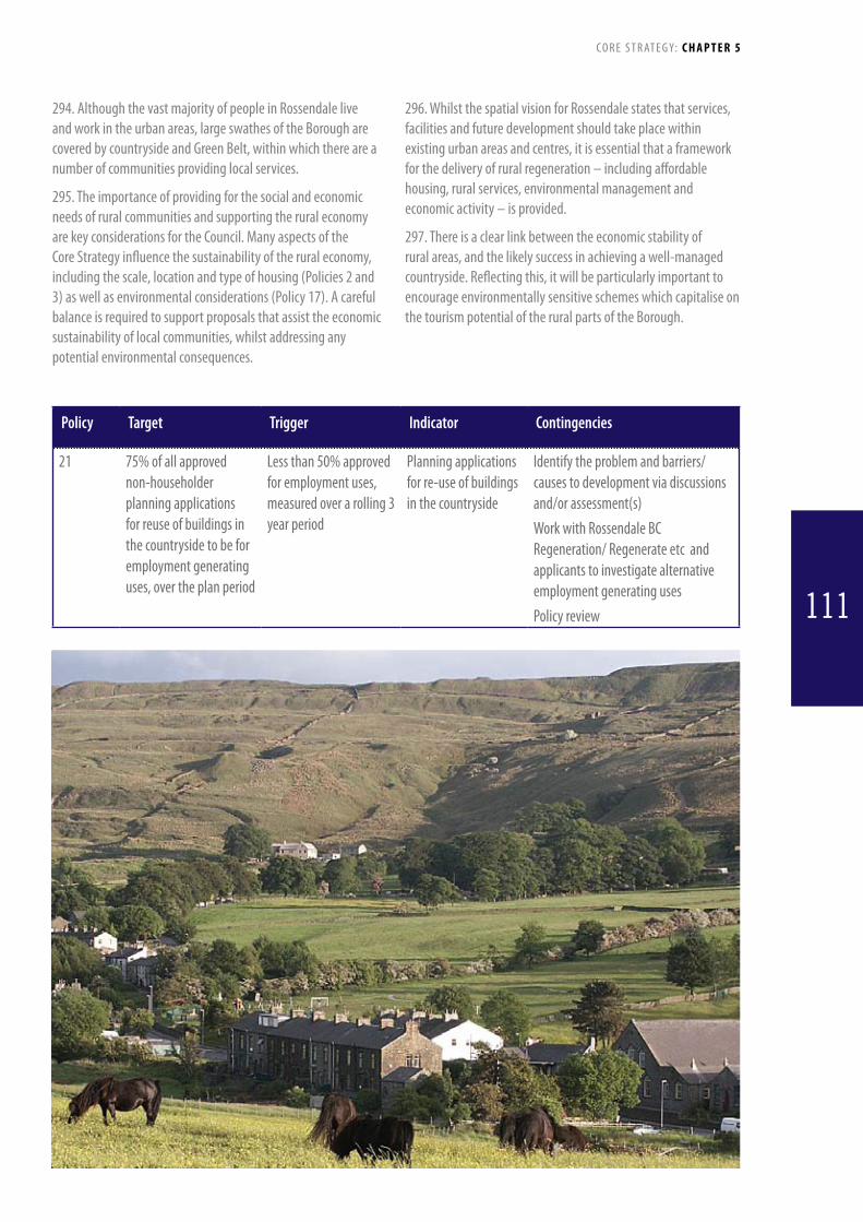
294. Although the vast majority of people in Rossendale live and work in the urban areas, large swathes of the Borough are covered by countryside and Green Belt, within which there are a number of communities providing local services.
295. The importance of providing for the social and economic needs of rural communities and supporting the rural economy are key considerations for the Council. Many aspects of the Core Strategy influence the sustainability of the rural economy, including the scale, location and type of housing (Policies 2 and 3) as well as environmental considerations (Policy 17). A careful balance is required to support proposals that assist the economic sustainability of local communities, whilst addressing any potential environmental consequences.
296. Whilst the spatial vision for Rossendale states that services, facilities and future development should take place within existing urban areas and centres, it is essential that a framework for the delivery of rural regeneration – including affordable housing, rural services, environmental management and economic activity – is provided.
297. There is a clear link between the economic stability of rural areas, and the likely success in achieving a well-managed countryside. Reflecting this, it will be particularly important to encourage environmentally sensitive schemes which capitalise on the tourism potential of the rural parts of the Borough.
Policy Target Trigger Indicator Contingencies
21 75% of all approved non-householder planning applications for reuse of buildings in the countryside to be for employment generating uses, over the plan period
Less than 50% approved for employment uses, measured over a rolling 3 year period
Planning applications for re-use of buildings in the countryside
Identify the problem and barriers/causes to development via discussions and/or assessment(s)Work with Rossendale BC Regeneration/ Regenerate etc and applicants to investigate alternative employment generating usesPolicy review
C O R E S T R AT E G Y: C H A P T E R 5
111

Policy 22: Planning Contributions
PLANNINGOBLIGATIONSWheredevelopmentswillcreateadditionalneedforimprovements/provisionofservicesorfacilitiesorexacerbateanexistingdeficiency,contributionswillbesoughttoensurethattheappropriateenhancements/improvementsaremade,andappropriatemanagementarrangementsareinplace.Contributionswillbesoughtfor(butnotlimitedto)thefollowingareas:• SustainableWasteManagement• CountrysideAccess• BuiltHeritage• AffordableandSupportedHousing,includingGypsy,TravellerandTravellingShowpeopleSites• CrimeandDisorder• LandscapeCharacterandDesign• GreenInfrastructure• NaturalHeritage• Biodiversity• Youth&Community• InlandWaterways• PublicRealmandPublicArt• LowandZeroCarbonEnergyGeneration• EnergyEfficiency• Provision/fundingfortrainingandemploymentopportunitiesforlocalresidentsWhereproposalsinvolvethedevelopmentofpreviously-developedlandorbuildings,theCouncilwillonlyapplythosecontributionsdeemedessential/criticaltohelpdeliverthesiteand/orprovidebenefitstotheimmediatecommunity.FurtherguidanceonplanningobligationswillbeprovidedinasubsequentSupplementaryPlanningDocument(SPD).COMMUNITYINFRASTRUCTURELEVY(CIL)/TARIFFBASEDAPPROACHTheprovision,maintenanceandimprovementofRossendale’sinfrastructureiskeytothecreationofsustainablecommunitiesanddeliveryofdevelopment.UnderthePlanningAct2008andtheCommunityInfrastructureLevyRegulations2010,infrastructureincludes:• Roadsandothersustainabletransportfacilities• Flooddefences• Schoolsandothereducationalfacilities• Medicalfacilities• Sportingandrecreationalfacilities;and• OpenspacesTheCouncilintendstoapplyplanningobligationstotheaboveformsofinfrastructureinaccordancewiththeSection106testssetoutintheCommunityInfrastructureLevyRegulationsuntilsuchatimeastheCouncilhaspreparedaChargingScheduleforeitherCILoraTariffbasedapproach.
298. This policy sets out the overarching framework in relation to the negotiation of planning obligations, agreements and the Community Infrastructure Levy (CIL).
299. In implementing this policy and determining priorities
for negotiating a planning obligation or agreement, the policy tests as contained in Circular 05/2005 (to be replaced by a new s106 policy annex) and where appropriate the Community Infrastructure Levy Regulations will be applied. In doing so the Council will have regard to:
C O R E S T R AT E G Y: C H A P T E R 5
112
• Keystrategicissues-supportingthevision,aimsandobjectives of the Local Strategic Partnership’s Sustainable Community Strategy as articulated in the Council’s Corporate Plan and the Core Strategy.
• Keylocalneeds–asidentifiedthroughcommunityandevidence base documents such as local housing needs studies, playing pitch and sports facility studies, education plans and other evidence base documents relating to the needs of specific areas within Rossendale.
300. It is important that development costs including the cost of implementing planning agreements do not prejudice development that supports the Council’s aspiration to see the regeneration and improvement of the Borough. If it is claimed that a development is unable to support the costs of a planning obligation (other than those essential to allow the development to proceed) then this could be the subject of negotiations. In such cases, the developer will have to demonstrate non viability via an “open book” approach. Normal development costs and the costs of high quality building materials and urban design considerations are universally applicable, and will not be allowed for in negotiations to reduce planning obligations.
301. Planning agreements will be drafted by the Council, and where appropriate, wil be based on model heads of terms which will be agreed with the developer, who will be responsible for the
costs incurred in preparing the agreement. The developer will also be required to pay a fee for the Council’s costs in administering and monitoring the agreement.
302.ASupplementaryPlanningDocumentwillbepreparedto amplify the policy, identify priorities and set out the criteria for calculating planning obligations as well as details on administration and monitoring fees.
303. In addition, the Council will consider implementing the Community Infrastructure Levy (CIL) to implement a standard charge for developments which put increased pressure on existing infrastructure.
304 A detailed infrastructure assessment of the Borough and an infrastructure delivery plan will be prepared and maintained throughout the course of the plan period and beyond, should the Community Infrastructure Levy be considered appropriate for Rossendale.
305. Moreover, it should be noted that planning obligations and possibly the introduction of a Community Infrastructure Levy will form part of a much wider plan/ programme to secure the provision/ improvement of infrastructure, services and facilities. Provision and funding for new and upgraded facilities etc will also be sought from various funding sources and providers
Policy Target Trigger Indicator Contingencies
22 All major applications to provide contributions towards improvements/provision of facilities where appropriate
80% or less of major proposals providing contributions
Planning approvals and Section 106 monitoring
Identify the problem and barriers/causes to development via discussions and/or assessment(s)Update evidence baseRenegotiate terms and detailsFocus on target areas
C O R E S T R AT E G Y: C H A P T E R 5
113
Policy 23: Promoting High Quality Design and SpacesTheCouncilwillensurethatRossendale’splacesandbuildingsareattractive,safeandeasytouse,byensuringthatallnewdevelopments:• PromotetheimageoftheBorough,throughtheenhancementofgatewaylocationsandkeyapproachcorridors• Areofthehigheststandardofdesignthatrespectsandrespondstolocalcontext,distinctivenessandcharacter• Contributepositivelytolocalidentityandheritageintermsofscale,density,layout,materialsandaccess• Maintaintherelationshipbetweentheurbanareasandcountryside,particularlyattherural-urbaninterface
where the contrast between the natural and built environments is most prominent• Havepublicandprivatespacesthataresafe,attractive,easilydistinguished,accessibleandcomplementthe
existingbuiltform• Protectimportantlocalandlonger-distanceviews• Uselocallysourcedsustainable,highqualityandinnovativematerialsappropriateforthedevelopmentandits
surroundingsincludingrecycledmaterialswhereverfeasible• Engagewiththeirsurroundingsandprovideadequatenaturalsurveillance(overlooking)forneighbouring
streets and spaces• Promotinghighqualitylandscapingandconstructionforstreetsandpublicspaces• Incorporatewelldefinedandrecognisableroutes,spaces,interchanges,landmarksandentrancesreflecting
guidancein“ManualforStreets”thatprovidesforconvenientmovementthatarewellconnectedtopublictransport,communityfacilitiesandservicesofindividualcommunitiesandneighbourhoods,withoutcompromising security
• Incorporatecarparkingdesignthatisintegratedwiththeexistingpublicrealmandotherpedestrianandcycleroutes
• Createasenseofownershipbyprovidingacleardefinitionbetweenpublicandprivatespaces• Aredesignedtomakecrimedifficulttocommitbyincreasingtheriskofdetectionandprovide(wherenecessary)
forwelldesignedsecurityfeatures• Provideplacesthataredesignedwithmanagementandmaintenanceinmind,avoidingthecreationofgated
communities• Beflexibletorespondtofuturesocial,technologicalandeconomicneeds• Provideactivegroundfloorfrontageswherelocatedintownanddistrictcentres• ContributetoareductioninenergyconsumptionandCO2emissionsandfacilitateadaptationtoclimatechange
throughefficientlayoutsanddesignswhichaccordwithorexceedcurrentnationalstandards(suchasCodeforSustainableHomes,BREEAMandBuildingRegulations)
• AresubjecttoaBuildingforLifeassessmentwherethedevelopmentinquestionisamajorresidentialscheme
306. High quality design that is responsive to the local context is essential if the character of Rossendale is to be both protected andenhanced.Designsbasedonstandardtemplatesappliedona national basis may not be appropriate, especially in sensitive locations. A high quality built environment involves consideration of the visual appearance of individual buildings but also how those buildings relate to the places in which they are located. In Rossendale the relationship of town and countryside, hill and valley, stone and other materials are particularly important. The topography of the area means that visual impact of an individual building or group of buildings can be as greater when looked down upon from higher ground or from the valley below than it is within its immediate situation. Scale, massing, materials and
roofscape can all significant factors. All proposals will therefore be considered for their impact on the broader surroundings as well as on the local area.
307. The effect of constricted valley floors together with steep hillsides is that in many locations in the Borough there is a very distinct urban/rural interface with terraced streets ending at the edge of a field. The impact of new development on the integrity of the urban boundary is a factor that, where relevant, developers will be expected to demonstrate in their submissions.
308. Much of the character of the built environment reflects the use of local materials, particularly stone. The design of new
C O R E S T R AT E G Y: C H A P T E R 5
114
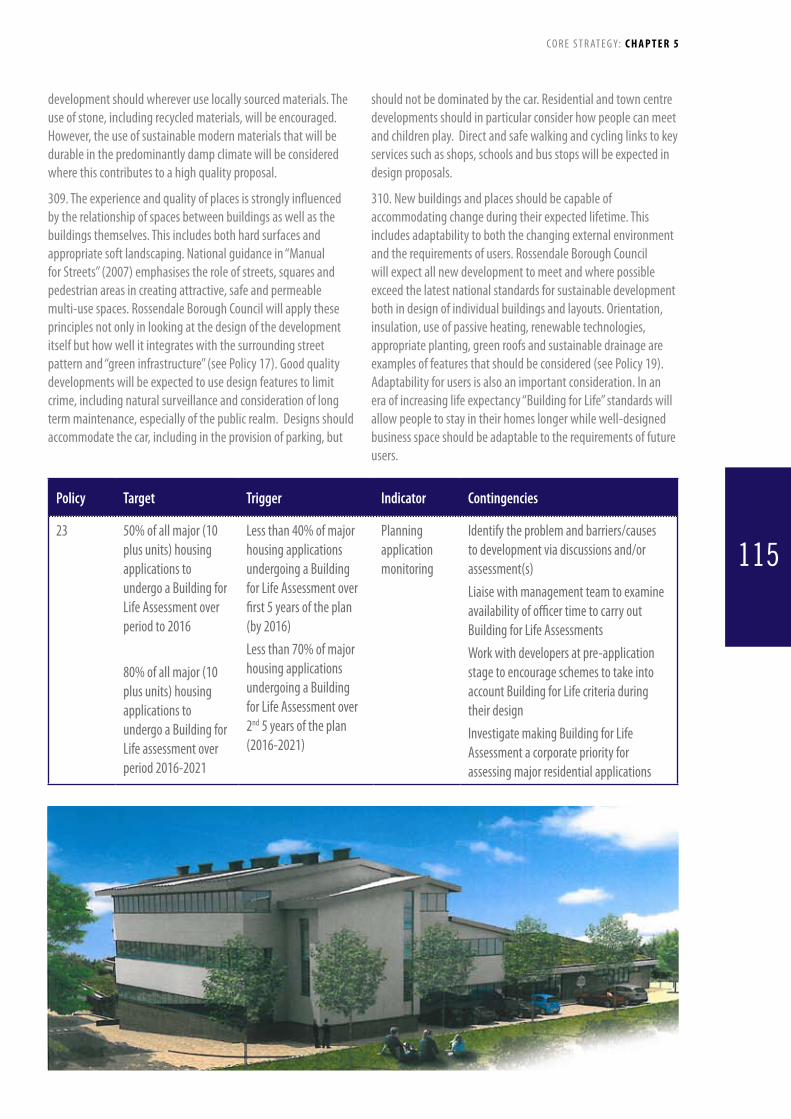
development should wherever use locally sourced materials. The use of stone, including recycled materials, will be encouraged. However, the use of sustainable modern materials that will be durable in the predominantly damp climate will be considered where this contributes to a high quality proposal.
309. The experience and quality of places is strongly influenced by the relationship of spaces between buildings as well as the buildings themselves. This includes both hard surfaces and appropriate soft landscaping. National guidance in “Manual for Streets” (2007) emphasises the role of streets, squares and pedestrian areas in creating attractive, safe and permeable multi-use spaces. Rossendale Borough Council will apply these principles not only in looking at the design of the development itself but how well it integrates with the surrounding street pattern and “green infrastructure” (see Policy 17). Good quality developments will be expected to use design features to limit crime, including natural surveillance and consideration of long termmaintenance,especiallyofthepublicrealm.Designsshouldaccommodate the car, including in the provision of parking, but
should not be dominated by the car. Residential and town centre developments should in particular consider how people can meet andchildrenplay.Directandsafewalkingandcyclinglinkstokeyservices such as shops, schools and bus stops will be expected in design proposals.
310. New buildings and places should be capable of accommodating change during their expected lifetime. This includes adaptability to both the changing external environment and the requirements of users. Rossendale Borough Council will expect all new development to meet and where possible exceed the latest national standards for sustainable development both in design of individual buildings and layouts. Orientation, insulation, use of passive heating, renewable technologies, appropriate planting, green roofs and sustainable drainage are examples of features that should be considered (see Policy 19). Adaptability for users is also an important consideration. In an era of increasing life expectancy “Building for Life” standards will allow people to stay in their homes longer while well-designed business space should be adaptable to the requirements of future users.
Policy Target Trigger Indicator Contingencies
23 50% of all major (10 plus units) housing applications to undergo a Building for Life Assessment over period to 2016
80% of all major (10 plus units) housing applications to undergo a Building for Life assessment over period 2016-2021
Less than 40% of major housing applications undergoing a Building for Life Assessment over first 5 years of the plan (by 2016)Less than 70% of major housing applications undergoing a Building for Life Assessment over 2nd 5 years of the plan (2016-2021)
Planning application monitoring
Identify the problem and barriers/causes to development via discussions and/or assessment(s)Liaise with management team to examine availability of officer time to carry out Building for Life AssessmentsWork with developers at pre-application stage to encourage schemes to take into account Building for Life criteria during their designInvestigate making Building for Life Assessment a corporate priority for assessing major residential applications
C O R E S T R AT E G Y: C H A P T E R 5
115

Policy 24: Planning Application RequirementsInadditiontoadheringtothepoliciesofthisPlanasawhole,applicationswillbegivenpositiveconsiderationsubjecttoalltherelevantrequirementsbelowbeingproperlyaddressedinthesupportingdocumentation.Theserequirementswillincludewhetherthedevelopment:1. Hasadequatelyconsideredtheonandoff-siteimpactsoftheproposalintermsofclimatechange,floodrisk,
wildlife,naturalresourceuse,pollutionandairqualityandidentifiedanymeasuresnecessaryformitigationand/or enhancement
2. Maximisesenvironmentalperformanceincludingmeetingandwherepossibleexceedinglatestgoodpracticeguidancesuchas“CodeforSustainableHomes”and“BuildingforLife”,managementofconstructionwaste,passiveheating/coolingandprovisionofonandoff-siterenewableenergyand/orheat
3. Makesefficientuseofland,includingwhereappropriateprovidingfordualuseandco-locationoffacilities4. Positivelycontributestothetownscape,historicenvironment,localdistinctiveness,landscape,biodiversityand
provisionof“GreenInfrastructure”5. Iscompatiblewithitssurroundingsintermsofstyle,siting,layout,orientation,visualimpact,localcontextand
views,scale,massing,height,density,materialsanddetailing6. Incorporatespublicspaces,landscaping,usableopenspaceandpublicart7. Protectstheamenityofthearea,includingresidentialamenityintermsofsatisfactorydaylight,sunlight,
outlook,privacy,softlandscapingandbymitigatingnoiseandlightpollution8. Contributetopublicsafetyincludingthrough‘securedbydesign’initiatives9. Providesdirectwalking,cyclingandpublictransportaccessandaddressesparking(allmodes)andservicing
issuesaspartofoveralldesignqualityincludingthroughTravelPlanning10.Demonstratesthatexistingdrainage,wastewaterandsewerageinfrastructurecapacityismaintainedand
wherenecessaryenhanced,toenabledevelopmenttoproceedincluding,whereappropriate,theuseofsustainabledrainagesystems(SuDS)
11.Ensuresthatsustainablestorageanddisposalofsolidwasteispositivelyaddressedwithinthedesign12.Ensureswhereappropriate,equalityofaccessanduseforallsectionsofthecommunityincluding,forresidential
proposals,deliveryof“LifetimeHomes”requirements13.ConformstopolicieswithinMineralsandWasteLDFdocumentsincludingsafeguardingofresources.Inaddition
extractionofshallowcoalshouldbeconsideredbeforeconstructioncommencesondevelopmentsaffectingknown deposits
14.Identifiesandadequatelyaddressesanyissuesofcontaminationorlandinstability,andincorporatesalandremediationscheme(whereappropriate)tothesatisfactionoftherelevantagency
311. This policy sets out topics relevant to the consideration of all planning applications that developers will be expected to consider when making submissions for planning permission. It is not a fully comprehensive list of every matter. Rather it builds upon and should be read alongside the other policies of the Core StrategyinparticulartheOverallDevelopmentApproachsetoutinPolicy1andtheDesignprinciplessetoutinPolicy23.ItdoeshoweverprovidesaclearindicationoftheprincipalDevelopmentManagement issues that the Council expects to be relevant when considering planning applications.
312. It is recognised that not all policy requirements will be relevant to every location. For example, both the presence of shallow coal and contaminated land are site specific. The intention is to provide a mechanism to ensure that applicants have given proper consideration to all relevant factors, including
giving attention to detailed local considerations. Through this process the policy aims to ensure that development is of a high quality, effectively manages resources, takes place in the right locations and is designed to ensure acceptable impacts on others andontheenvironment.DeveloperswillbeexpectedtoexplicitlyaddressthepolicyrequirementswithintheDesignandAccessStatement submitted with their application. Other relevant documentation such as Transport Assessments, Travel Plans and Environmental Impact Assessments will also be required where development exceed the current national thresholds or at lower levels where the Council considers them appropriate. Relevant specialist bodies such as the County Council and the Environment Agency will be consulted as appropriate as well as internal consultees on matters such as air and noise pollution. The overall intention is to facilitate high quality schemes that reflect
C O R E S T R AT E G Y: C H A P T E R 5
116

the overall policy emphasis of the plan and also address detailed on-site issues that can make a significant difference to the overall functioning of the proposal.
313. “Public spaces” and “usable open space” in Bullet 6 are related but different terms. “Public Spaces” are areas of all types which are not constrained by private ownership where people can meet. This can include streets, squares and greenspace. “Usable Open Space” includes parks, playgrounds, public playing fields and informal open space.
314. Lancashire County Council is the Mineral Planning Authority for the Rossendale area. A Minerals and Waste Core Strategy has already been approved. All applications that primarily involve minerals or waste disposal are decided by the County Council. Where a proposal being considered by Rossendale Borough Council affects known mineral reserves the County Council, and where appropriate, the Coal Authority will be consulted.
315. Following adoption of the Core Strategy the Council will prepareaSiteAllocationsandDevelopmentManagementDPD.ItisintendedthatthiswillincludeasmallnumberofkeyDevelopmentManagementpoliciesthatwillprovidefurtherguidance for developers and officers. The Council also intends to produceSupplementaryPlanningDocumentswhichwillinterpretand expand this policy for specific developments, including mostparticularlyaDesignSPD,aRenewableEnergyandEnergyEfficiencySPDandSPD’sforeachofmainthetowncentres.UntiltheseSPDsareproduced,anycurrentrelevantexistingSupplementaryPlanningGuidancenotes/Documentswillbeused, including:
• AlterationsandExtensionstoResidentialPropertiesSPD
• OpenSpaceandPlayEquipmentContributionsSPD
• Re-UseofBuildingsintheCountrysideSPD
Policy Target Trigger Indicator Contingencies
24 To decrease the amount of both derelict and vacant land in the borough over the Plan period to 2026
Amount of derelict land increases by more than 10% over a rolling 5 year period Amount of vacant land increases by more than 10% over a rolling 3 year period
NLUDSrecordsforconstituent years
To identify the issues affecting increased rates of vacant land (e.g. factory closures, costly contamination issues)To work with HCA and other funding bodies (e.g. LEP, to bring forward sites)To work with landowners to find ways of bringing forward vacant land that market finds difficult to address
C O R E S T R AT E G Y: C H A P T E R 5
117

CHaPtEr 6Delivery mechanisms and
risks
316. This chapter sets out the delivery mechanisms and contingencies for the Topic Planning Policies contained in the Core Strategy. One purpose of these policies is to deliver the Transformational Projects, which are discussed in Chapter 1 and referred to throughout the Core Strategy where appropriate. Hence the delivery mechanisms, risks and contingencies considered in this chapter for the Topic Planning Policies also address the Transformational Projects.
118
119

DeliveryAgencies: Rossendale Borough Council, Gypsy and Traveller community.
DeliveryMechanisms:SiteAllocationsDPD.
Risks(Low/Medium/High):Lackofsuitablesites(M/H);localcommunity resistance to establishment of Gypsy sites (H).
Training and Skills
Policy 6: Training and Skills
DeliveryAgencies:Accrington and Rossendale College, LancashireCountyCouncil,DfES,LearningandSkillsCouncil,localschools,LCDL,RossendaleBoroughCouncil,developers,JobCentre, employers.
DeliveryMechanisms: Negotiations with appropriate agencies, partnership working to secure grant funding, planning conditions and agreements.
Risks(Low/Medium/High):Unable to deliver buildings due to: lackofnationalfunding(M/H);lackofCountyCouncilfunding(H);failuretoagreeoperationalagreements(L/M).Unabletodeliver training and skills through employment due to: developer resistance(M/H);lackofsuitablepotentialemployees(M);nomechanism for enabling training (M).
Policy 7: Social Infrastructure
DeliveryAgencies:Developers,LancashireCountyCouncil,grant funding agencies, interest groups.
DeliveryMechanisms:Planning application process, effective negotiations with developers and funding / delivery agencies.
Risks(Low/Medium/High):Inadequate marketing of properties(H);lackofsupportfromPlanningInspectorsatappeal(M);lackofmarketdemand(M/H).
Transport and Accessibility
Policy 8: Transport
DeliveryAgencies:EastLancashireRailway,NetworkRail,DfT,Lancashire County Council, Transport For Greater Manchester, neighbouring authorities, bus operators, interest groups.
DeliveryMechanisms:DevelopmentofemploymentandhousingsitesinaccessiblelocationsthroughDPDs.Negotiationswith Lancashire County Council, TFGM and other stakeholders to pursue ELR commuter link.
Risks(Low/Medium/High):
Railway for commuter use:
Studyfindslackofbusinesscase(M/H);inadequatefundingavailable(M);lackofpartnersupport(L/M);technicalimplementation issues (M).
Park and Ride sites:
Unavailabilityofsuitablesites(M);accessissuestoandfromsite
120
Delivery Mechanisms and Risks
Development Locations
Policy 1: Main Development Locations
DeliveryAgencies:Developers,RossendaleBoroughCouncil,Partners, Local Economic and Enterprise Partnerships (LEP).
DeliveryMechanisms:DPDs,SPDs,effectivedevelopmentmanagement and Core Strategy policy implementation.
Risks(Low/Medium/High):Developerlandholdingsprimarilyoutsidemainlocations(L/M);Developmentopportunitiesinhardto service locations (L/M).
Housing
Policy 2: Meeting Rossendale’s Housing Requirement
DeliveryAgencies: House builders, landowners, Registered Social Landlords, Rossendale Borough Council, LEP.
DeliveryMechanisms: Work with key partners to stimulate the market,DPDs,SPDs,effectivedevelopmentmanagement.
Risks(Low/Medium/High): Significant problems in meeting requirementsdueto:marketrecession(H);unavailabilityoffundingfordevelopersandpurchasers(H);availabilityofsites(L/M);initialhighgreenfieldfiguresduetohistoricpermissions(H).
Policy 3: Distribution of Additional Housing
DeliveryAgencies:House builders, landowners, Registered Social Landlords, Rossendale Borough Council.
DeliveryMechanisms:DPDs,SPDs,negotiationswithdevelopers and landowners to promote house building in preferred locations.
Risks(Low/Medium/High):House builders and landowners onlypushsitesinlocationsattractivetomarket(H);higherlevelsofdevelopmentputforwardoutsideRawtenstall(H);shorttermsupply strongly influenced by location of existing permissions (M).
Policy 4: Affordable and Supported Housing
DeliveryAgencies:House builders, landowners, Registered Social Landlords, Rossendale Borough Council.
DeliveryMechanisms:DPDs,SPDs,negotiationswithhousebuilders, planning conditions, effective monitoring.
Risks(Low/Medium/High):Lack of value in market housing foraffordablehousing(M);ShortageoffundingforHousingAssociations (M).
Policy 5: Meeting the Needs of Gypsies, Travellers and Travelling Showpeople
C O R E S T R AT E G Y: CHAPTER 6
120

(M);unsuitabilityforoperators(M).
Bus station:
Availabilityoffunding(M);agreementonpreferredsite(L/M);establishing suitable access arrangements (M).
Highway improvements including bus lanes:
Significantimprovementstogyratorytooexpensive(M/H);buslaneproposalsresultinsignificantobjections(M);buslanesmakecar congestion worse (M/H).
Car parking:
Opposition to principles of parking policy (M).
Policy 9: Accessibility
DeliveryAgencies: Bus operators, Lancashire County Council, voluntary groups, Rossendale Borough Council, developers, Groundwork, landowners.
DeliveryMechanisms:SiteAllocationsDPD,planningapplication process.
Risks(Low/Medium/High): Bus operators withdrawing services(M/H);CountyCouncilsubsidiesreduced(M/H);limitedabilityofvoluntarygroupstodeliverservices(M);developerresistancetohighqualitydevelopment(M);LancashireCountyCouncil(Highways)resistancetodesigns(L/M);lackoffundingforlongdistancetrailsandcycleways(M);lackofbroadbanddelivery to areas currently lacking high-speed access (L/M).
Employment, Retail and Tourism
Policy 10: Provision for Employment
DeliveryAgencies:Developers,existingemployers,LEP,HCA,LCDL,RossendaleBoroughCouncil,RegeneratePennineLancashire.
DeliveryMechanisms:DPD’s,SPD’s,planningapplicationsprocess, management of developer investment.
Risks(Low/Medium/High):Lack of site owner interest in refurbishingexistingkeysites/buildings(M);pressuretodevelopallocatedemploymentsitesforalternativeuses(M);lackofdemandfortowncentreofficesites(M/H);lackofsuitablesitesfor new employment (L/M).
Policy 11: Retail and other Town Centre Uses
DeliveryAgencies: Rossendale Borough Council, developers, retailers, interest groups, Lancashire County Council, LEP, HCA.
DeliveryMechanisms:DPD’sandSPD’s.TownCentreMasterplans, planning application process.
Risks(Low/Medium/High): Retailers and leisure operators unwillingtoinvestintowncentres(M);highnumberofvacanciesin Town Centres (M).
Policy 12: The Valley Centre
DeliveryAgencies:Owner, Rossendale Borough Council, LancashireCountyCouncil,businessinterests,LCDL,developers,LEP.
DeliveryMechanisms: Management of developer investment, planning application process, consideration of Compulsory Purchase Order, development partnership.
Risks(Low/Medium/High):Difficultiesinidentifyingeconomicallyviablescheme(M/H);ownerresistancetoalternativeschemes(M/H);lackofnationalretailerinterest(M);landassemblyproblems(M);highwayandtransportdifficulties(M);lackoffundingforhighqualityphysicalenvironment(M).
Policy 13: Protecting Key Local Retail and other Services
DeliveryAgencies:RossendaleBoroughCouncil;privatetraders;propertyindustry;voluntarygroups;fundingbodies.
DeliveryMechanisms:DPDsandSPDs,planningapplicationprocess.
Risks(Low/Medium/High): Lack of market interest from potentialoccupiers(M/H);Reducingpatronageofmarkets(M);inadequate marketing (H).
Policy 14: Tourism
DeliveryAgencies:Developers,LancashireandBlackpoolTouristBoard, Rossendale Borough Council, Lancashire County Council, fundingbodies,touristindustry,LCDL,landowners.
DeliveryMechanisms:SPDsandDPDs,managementofdeveloper investment, working with partners to secure funding for tourist developments.
Risks(Low/Medium/High):Lack of available funding for key projects(M);Lackofinvestorinterestinsupportinginfrastructure(M);lackofvisitornumbers(L/M);lackofmarketing(L/M).
Policy 15: Overnight Visitor Accommodation
DeliveryAgencies:Developers,TouristBoard,RossendaleBorough Council, Lancashire County Council, funding bodies, hoteliers, accommodation providers, business support agencies.
DeliveryMechanisms:SPDsandDPDs,planningapplicationprocess, management of developer investment and promotion of the Borough’s tourist industry as an incentive for investment.
Risks(Low/Medium/High):Lackofinvestorinterest(M/H);lackofsuitablesites(L/M);lackofvisitors(L/M);lackoftailoredsmallbusiness support (L/M).
The Natural and Built Environment and Low and Zero Carbon Energy
Policy 16: Preserving and Enhancing
C O R E S T R AT E G Y: CHAPTER 6
121

Rossendale’s Built Environment
DeliveryAgencies:Rossendale Borough Council, English Heritage,Developersandbuildingowners,CivicTrust,LancashireCounty Council, voluntary groups, Natural England, Groundwork.
DeliveryMechanisms:DPDs,SPDs,Masterplans,managementof Conservation Areas, planning application process.
Risks(Low/Medium/High):Financial cost of repairing/enhancingstructures(M/H);concentrationsofbuildingsinpoorstateofrepair(M);Ownerresistancetomaintainingkeystructures(M);lackoflongtermgrantsandsupport(especiallyincertainareas)(M);worksundertakenwithoutpermission(M).
Policy 17: Rossendale’s Green Infrastructure
DeliveryAgencies:Rossendale Borough Council, Natural England, Environment Agency, Regenerate Pennine Lancashire, Forestry Commission (English Woodland Grant Scheme), Civic Trust, interest groups, Lancashire County Council, Groundwork, landowners,DEFRA.
DeliveryMechanisms:DPDs,SPDs,planningapplicationprocess, coordination of projects with Rossendale Borough Council’s ‘Green Team’ and other relevant organisations, integrated public rights of way planning with Lancashire County Council.
Risks(Low/Medium/High): Lack of awareness of need for GreenInfrastructureprovision(M);unavailabilityoffundingforrelevantmaintenance/enhancement(M);lackofco-ordinationbetween relevant parties (M).
Policy 18: Biodiversity, Geodiversity and Landscape Conservation
DeliveryAgencies:Rossendale Borough Council, Natural England, Local Communities, Regenerate Pennine Lancashire, Environment Agency, Lancashire County Council NHES, Rochdale Metropolitan Borough Council, landowners.
DeliveryMechanisms: Management of development through planningapplicationprocess,allocationoflandthroughtheLDF,consultation with Natural England, Lancashire County Council and other stakeholders.
Risks(Low/Medium/High): Lack of awareness of relevant designationsandlocalsensitivities(M);unavailabilityoffundingforrelevantmaintenance/enhancement(M);lackofco-ordinationbetweenrelevantparties(M);unwillingnessoflandowners to cooperate (H).
Policy 19: Climate Change and Low and Zero Carbon Sources of Energy
DeliveryAgencies: Rossendale Borough Council, Renewable energy developers, interest groups, national and regional bodies, Building Control and Approved Inspectors, Lancashire County Council, EA, developers, utility companies.
DeliveryMechanisms:NationalPolicyStatements,DPDs,SPDs,sub-regionalfeasibility/impactstudies,discussionswithdevelopers and other stakeholders, management of developer investment.
Risks(Low/Medium/High):(M);lackofdeveloperinterestinsometechnologies;publicopposition(M/H);PlanningInquirydecisions(M);limitedabilitytoviablydeliverrenewablesinsomesectors (M/H)
Policy 20: Wind Energy
DeliveryAgencies: Rossendale Borough Council, Renewable energy developers, interest groups, national and regional bodies, Building Control and Approved Inspectors, Lancashire County Council, Environment Agency, developers, utility companies, Major Infrastructure Planning Unit.
DeliveryMechanisms:NationalPolicyStatements,DPDs,SPDs,sub-regionalfeasibility/impactstudies,discussionswithdevelopers and other stakeholders, management of developer investment.
Risks(Low/Medium/High): Conflict between landscape qualityissuesandwindenergyproposals(H);viabilityissueson enhancing energy efficiency of existing housing stock (M);developerresistancetoplanningobligations(M);publicopposition (H).
Policy 21: Supporting the Rural Economy and its Communities
DeliveryAgencies:RossendaleBoroughCouncil,DevelopmentAgency, NFU, Lancashire County Council, voluntary groups, Country Landowners Association, LEP.
DeliveryMechanisms:planning application process, allocation oflandthroughLDF.
Risks(Low/Medium/High): Inappropriate development proposalsinthecountrysideareproposed(M);ruraldiversification schemes are refused without clear justification (L/M).
Development Management
Policy 22: Planning Contributions
DeliveryAgencies:Rossendale Borough Council, Lancashire CountyCouncil,Developers,Infrastructureproviders,neighbouring authorities, planning agents.
DeliveryMechanisms:DPDsandSPDs,managementofdeveloperinvestment,allocationoflandthroughLDF,planningapplication process.
Risks(Low/Medium/High):Developerresistancetoplanningobligations(M/H);ifCommunityInfrastructureLevyoratariff-based system adopted, need to establish viability and infrastructurerequirements(M/H);amountoftime/resources
C O R E S T R AT E G Y: CHAPTER 6
122

tonegotiateagreements(M);changingeconomicconditionsundermine viability (M/H).
Policy 23: Promoting High Quality Design and Spaces
DeliveryAgencies:Rossendale Borough Council, developers, planning agents, architects, householders, stakeholders.
DeliveryMechanisms:DPDs,SPDs,masterplans,determinationof planning applications, pre-application discussions, Building For Lifeassessmentprocedures,DesignReviewPanelreferrals.
Risks(Low/Medium/High):High quality design not given due attentioninproposals(M/H);implementationofdesignfeaturesmakes schemes unviable (M/H), lack of applicants coming forward for pre-application discussions (M).
Policy 24: Planning Application Considerations
DeliveryAgencies:Rossendale Borough Council, developers, planning agents, householders, stakeholders.
DeliveryMechanisms:DPDsandSPDs,determinationofplanning applications.
Risks(Low/Medium/High):Submitted proposals do not meetoneormorepolicycriteria(M/H);criteriaforpoliciesnotsupportedatappeals(L/M);implementationofcriteriamakesschemesunviable(M/H);lackofapplicantscomingforwardforpre-application discussions (M).
Transformational and key Projects
The Adrenaline Gateway
Desirable/Essential:Essential
KeyPartners:Rossendale Borough Council, Lancashire County Council, developers, Lancashire and Blackpool Tourist Board, Groundwork,LancashireCountyDevelopmentsLimited(LCDL),LEP, landowners, interest groups.
KeyDeliveryPolicies:Area Vision Policies, Policy 1, Policy 14, Policy 15, Policy 17, Policy 21.
CommittedFunding: Funding in place for Lee Quarry / Crag QuarryextensionandlinktoPennineBridleway.£50,000(LCDL)secured for feasibility study into indoor facility at Futures Park (Ice climbing wall).
PossibleFunding:LCDL.
CurrentStatus:Branding of a collection of facilities throughout Rossendale including: Lee Quarry mountain bike facility, Cragg Quarry mountain bike facility, multi-user bridleway between Lee and Cragg quarries, Facit Quarry mountain bike facility (to be developed 2011), Landgate Quarry mountain bike facility (to be developed 2011), multi-user bridleway linking Lee Quarry with Facility and Landgate quarries (to be developed 2011), indoor adrenaline sports facility at Futures Park (planned – funding currently being finalised). Ski Rossendale and the water-skiing
facility at Cowm Reservoir may potentially also come under the Adrenaline Gateway brand in future.
LevelofRisk: Low / Medium (Footpaths / bike trails) Medium / High(Developments)
ContingencyApproach:Seek alternative funding sources, maintain concentration on promotion of footpaths / rights of way for walking, bridleways for cycling.
Bacup Town Centre Regeneration and Renaissance
Desirable/Essential:Essential
Key Partners: Rossendale Borough Council, developers, English Heritage, Regenerate Pennine Lancashire, shop owners, building owners, tenants, users.
CommittedFunding:Limited at present.
KeyDeliveryPolicies:Area Vision Policy 2, Policy 1, Policy 11, Policy 13, Policy 14, Policy 16.
PossibleFunding:HCA, LEP.
CurrentStatus: Previous research carried out, Conservation Area Appraisal being carried out.
LevelofRisk: Medium / High
ContingencyApproach: Focus regeneration on selected key buildings and sites, selective demolition.
Rossendale Health Campus
Desirable/Essential:Essential
KeyPartners: East Lancashire Primary Care Trust.
KeyDeliveryPolicies: Policy 7.
CommittedFunding: £10 million.
PossibleFunding: N/A
CurrentStatus:Delivered–becameoperationalinMay2010.
LevelofRisk: Low
ContingencyApproach: N/A
Commuter Rail Link
Desirable/Essential: Essential
KeyPartners: Lancashire County Council, TFGM, Rossendale Borough Council, ELR, Network Rail, Bury and Rochdale Councils.
KeyDeliveryPolicies: Policy 1, Policy 8, Policy 9, Policy 14, Area Vision Policy 4.
CommittedFunding:£75,000 for East Lancashire / West Rochdale Area Study.
PossibleFunding: TFGM Transport Fund (potentially £20 million), Lancashire County Council.
C O R E S T R AT E G Y: CHAPTER 6
123
CurrentStatus: Study being undertaken, due for publication end of 2010.
LevelofRisk: Medium / High
ContingencyApproach: Bus priority measures on A56 / M66, traffic management.
Haslingden Renaissance Plan
Desirable/Essential:Essential
KeyPartners: Rossendale Borough Council, Groundwork, developers, neighbouring authorities.
KeyDeliveryPolicies:Area Vision Policy 6, Policy 1, Policy 11, Policy 13, Policy 16.
CommittedFunding: Rossendale Sustainable Economic DevelopmentProgramme.
PotentialFunding:LCDL.
CurrentStatus: Public Realm Strategy consultation held in summer 2010. Currently seeking funding.
LevelofRisk:Medium/High
ContingencyApproach:Focus regeneration on selected key buildings and sites, selective demolition.
Rawtenstall Town Centre Regeneration (Including The Valley Centre)
Desirable/Essential:Essential
KeyPartners:Developers,RossendaleBoroughCouncil,Lancashire County Council, Regenerate Pennine Lancashire.
KeyDeliveryPolicies:Area Vision Policy 4, Policy 1, Policy 11, Policy 12, Policy 13, Policy 14, Policy 16, Policy 23.
CommittedFunding: £10,000 for building wrap, Rossendale BoroughCouncilcommitmenttofundfeasibilitystudy/SPD(£40,000)andNWDA£50,000.
PossibleFunding: Lancashire County Council, Rossendale Borough Council, private investment.
CurrentStatus: High level steering / working group in place, s215 notice served, viability assessment being carried out, discussions ongoing with developers, masterplanning by consultants.
LevelofRisk:Medium
ContingencyApproach: Compulsory Purchase Order, negotiations with developer, negotiations with alternative developers.
New Hall Hey Development
Desirable/Essential: Essential
KeyPartners:Developers,RossendaleBoroughCouncil,LCDL.
KeyDeliveryPolicies: Area Vision Policy 4, Policy 1, Policy 11.
CommittedFunding: Administrator currently finalising release of the site.
PossibleFunding:LCDLforofficedevelopments.Possible£2millionfromERDF,possible£3millionfromLCDL.
CurrentStatus:Discussionswithadministrators,ERDFandLCDL,buildings on site being completed.
LevelofRisk:Low / Medium (retail), Medium / High (offices)
ContingencyApproach: Completion notice served to developer, renegotiation of Planning Permissions and s106 agreements.
Bacup 14-21 Vocational Education Campus
Desirable/Essential:Essential
KeyPartners:LancashireCountyCouncil,LCDL,Accrington&Rossendale College, Learning and Skills Council, local schools.
KeyDeliveryPolicies:Area Vision Policy 2, Policy 6, Policy 7.
PossibleFunding:Rossendale Borough Council and Accrington & Rossendale College.
CurrentStatus: Phase 1 to be onsite by the end of 2011.
LevelofRisk: Low/Medium
ContingencyApproach:Deliverthroughexistingschools
C O R E S T R AT E G Y: CHAPTER 6
124
Sustainability Appraisal A Sustainability Appraisal (SA) has been undertaken at all stages of the preparation of the Core Strategy. For this Pre-Submission version the Sustainability Appraisal has been undertaken by Atkins, and a Report outlining their findings accompanies the CoreStrategy.SAisalegalrequirementforDevelopmentPlanDocuments,assetoutinthe2004PlanningandCompulsoryPurchase Act. The requirement to undertake SA also includes the mandatory Strategic Environmental Assessment (SEA) as required under European legislation.
In the UK SEA and SA are combined into a unified process to ensure economic, social and environmental impacts of the proposed policies are assessed. Hence all references to SA will include the SEA too. SA is intended to be an iterative process to improve policies.
The UK advocates a 5 stage approach to SA. This has been carried out on the Core Strategy and includes the following stages:
Stage A – Assembly of the evidence base to inform the appraisal, and establish the framework for undertaking the appraisal (in the form of sustainability objectives).
Stage B – Appraisal of the plan objectives, options and preferred options / policies against the framework taking into account the evidence base, and propose mitigation measure for alleviating the plan’s adverse effects as well as indicators for monitoring the plan’s sustainability.
Stage C – Preparation of a sustainability appraisal report documenting the appraisal process and findings.
StageD–Consultationofstakeholdersontheplanandsustainability appraisal report.
Stage E – Monitoring the implementation of the plan (including its sustainability effects).
Habitats Regulations AssessmentUnder the Conservation of Habitats and Species Regulations 2010 (the Habitats Regulations) the first stage of the Habitat Regulations Assessment process (Stage 1 - Screening) has been undertaken on the Core Strategy in order to see whether its proposals could result in likely significant effects upon international sites. International sites are those that have been designated for their international nature conservation interests and include:
• SpecialAreasofConservation(SAC)designatedunderEuropeanCouncilDirective92/43/EEC(a)ontheConservationof Natural Habitats and of Wild Fauna and Flora (the Habitats Directive);
• SpecialProtectionAreas(SPA)designatedundertheEuropeanCouncilDirective79/409/EEContheConservationofWildBirds(theBirdsDirective);and,
• TheUKGovernmentintheCircularaccompanyingPlanningPolicy Statement 9 Biodiversity and Geological Conservation has as a matter of policy chosen to apply the Habitats Regulations Assessment procedures in respect of Wetlands of International Importance (Ramsar sites), candidate SACs (cSACs) and potential SPAs (pSPAs) even though these are not European sites as a matter of law.
There are no international sites within Rossendale. However there are five international sites within 25 km of the Core Strategy boundary including: Rochdale Canal SAC, South Pennine Moors SAC,PeakDistrictMoors(SouthPennineMoorsPhase1)SPA,South Pennine Moors SPA and Bowland Fells SPA.
The HRA of the Core Strategy has found that there are no likely significant effects on these five international sites. A copy of this assessment is available on request from Rossendale Borough Council.
HRA Process Going ForwardLower Tier Plans
In addition to the Core Strategy, all of Rossendale Borough Council’sLocalDevelopmentDocuments(LDDs)willbesubjecttothe HRA process. This will include the following plans:
• SiteAllocationsDevelopmentPlanDocument(DPD);
• AdoptedProposalsMapDPD;and,
The need to carry out the HRA process on Supplementary PlanningDocuments(SPD)willbereviewedandagreedwithNatural England when they are produced.
Should the HRA process on lower tier plans (such as the Site AllocationsDPD)determinethatthereareproposalsthatmightlead to likely significant effects on international sites, the Council will work with Natural England to agree suitable mitigation measures. However, should it not be possible to adequately mitigate the effects the proposal will not be included in the Plan. Where there are reasons of overriding public interest and the HRA is unable to conclude that there are no significant effects on the international site(s), the Secretary of State will be notified to allow them to call in the Plan for determination. In these situations compensatory measures to protect the international site(s) must be put in place.
Development Control
Any development proposals that arise from the policies within the Core Strategy that may have a likely significant effect on an international site will be subject to further consideration and assessmentthroughtheHRAprocess.Developerswillberequiredto provide the Competent Authority (in this case Rossendale Borough Council) with a thorough ecological assessment of the likely effects of the proposed development on the relevant international site (or sites) so as to allow the Competent Authority the ability to carry out the relevant stage(s) of the HRA process.
C O R E S T R AT E G Y: CHAPTER 6
125

Any development that, through the relevant stages of the HRA process, cannot demonstrate to the Competent Authority and Natural England that it would not have a significant effect on an international site (or that the effects can be adequately mitigated) will be refused. This is in accordance with the precautionary principle enshrined within the Habitats Regulations.
Where there are reasons of overriding public interest and the Competent Authority is unable to conclude no significant effects on the international site(s), the authority will notify the Secretary of State and allow them to call in the application for determination. In these situations compensatory measures to protect the international site(s) must be put in place.
APPENDIX ONE: Parking StandardsGeneral guidance
The following Parking Standards apply to all new development and changes of use. The standards are maxima with the exception of cycles, mobility impaired and motorcycles which are minimum standards and are based on net floor area.
Applicants will be expected to submit the attached Accessibility Questionnaire for all developments that require a full Transport Assessment.ThesethresholdsaresetoutintheDfTdocument“Guidance on Transport Assessment” (2007). The Council will consider reductions in parking levels on sites which demonstrate good accessibility by other modes.
Parking levels for all development should be considered as part of a broader appraisal of accessibility to the site by all modes with the aim of increasing use by walking, cycling and public transport and reducing car use as promoted in PPG13 “Transport”. Both theDesignandAccessStatementandanyTransportAssessmentshouldconsiderwideraccessintothesite;howwalkingandcyclinglinkscanbeenhancedbygooddesignandlayout;existingon and off-street parking provision and usage in the vicinity of the development and where appropriate parking management measures.
TravelPlanswillberequiredatthresholdssetoutinDfT“Guidanceon Transport Assessment” and will be expected to reflect latest good practice in developing an evidence base, setting targets and monitoring.
Detailed Issues
Cycling and motorcycles - provision for long stay parking (covered, secure) should be made at locations where users are likely to remain for more than 3 hours, such as employment sites with more than 30 staff. Other cycle and motorcycle parking should be secure (e.g. Sheffield stands), clearly signed and close to the main entrance to the building.
Cycle Parking should be based on 1 space per 10 car spaces
Motorcycle provision should be based on 1 space per 25 car spaces
A minimum of 1 space should be provided for developments with less than 10 spaces
Mobility impaired - Provision should be made on the basis of 1 per 10 car spaces unless the developer can prove the need for less. Where this is the case the lowest level of provision acceptable wouldbetherelevantfigurefromlatestDfTguidance.Aminimumof 1 mobility impaired space should be provided for smaller developments
“Parent and child” spaces should form a proportion of the overall mobility impaired standard at retail and leisure uses.
Covered, safe parking provision for mobility scooters should be made in new residential development where there is likely to be a high proportion of older or mobility impaired users.
Residential- Garages will not be counted towards parking provision figures unless suitable evidence is provided. A creative approach should be taken to residential parking design building in principles from “Manual for Streets” (2007) to ensure that layouts are not car dominated.
Provision should be made in family housing for secure provision for at least 2 cycles.
Mixed use - provision should be based on the proportion of the different uses. The only exception to this would be where there are significantlydifferentpatternsofoccupationbyusers;e.g.aschoolby day and leisure use in the evening in which case the standard for the use with the highest demand should be used.
Large open areas (e.g. Bulky goods warehouses) - parking levels should be reduced by 50% for large open areas.
Town centre uses - new parking provision proposals should be assessed against the overall supply and management of private and public on and off-street parking. Suitable management arrangements should be utilised, e.g. to manage short stay parking stay periods in line with the broader town centre parking strategy.
Uses not specified - these will be considered on a case by case basis.Developerswillbeexpectedtoprovideaclearrationaleforthe number of spaces provided.
Design - the design of parking should be of a high quality, incorporating clear pedestrian routes and good signage. Larger car parks should incorporate design features to break up large areas ofopenspace.Drainageshouldbesustainablewhereverpossibleand incorporate oil traps to prevent damage to surface water systems.
Coaches and Taxis - Pick up points for taxis should be provided at retail developments of over 2 500m² and major leisure developments. Coach parking/drop off points should be provided as appropriate, e.g. at leisure destinations.
Operational parking - requirements for operational parking and servicing should be set out separately in the Transport Assessment
C O R E S T R AT E G Y: CHAPTER 6
126

Land Use Standard Accessibility reduction
A1 Retail
Food 1:14m² 1:15-1:22m²Non Food 1:20m² 1:21-1:31m²A2 financial/Professional
1:30m² 1:31-1:48m²
A3 Restaurants 1:5m² 1:5-1:7.5m²A4 Drinking Premises 1:5m 1:5-1:7.5m²A5 Hot food Takeaways 1:8m² 1:8.5-1:12m²B1 Offices/Light Industry
Offices 1:30m² 1:31-1:48m²Call Centres 1:30m² 1:31-1:48m²Research and development
1:30m² 1:31-1:48m²
Light Industry 1:30m² 1:31-1:48m²Business Parks 1:35m² 1:37-1:54m²B2 General Industrial 1:45m² 1:47-1:69m²B8 Storage and Distribution
1:100m² 1:105-1:154m²
C1 Hotels & Boarding Houses
1 per bedroom including staff
n/a
C2 Residential Institutions
Nursing Homes 1 per 5 bedrooms n/aResidential training centres
1 per bedroom n/a
Hospitals 1 per bed plus 4 per consulting room
via Travel Plan
C3 Residential
Sheltered 1 per 3 bedrooms n/a1 bedroom 1 space via Travel Plan2-3 bedrooms 2 spaces via Travel Plan4 + bedrooms 3 spaces via Travel PlanD1 Non residential institutions
Medical and Health centres
1 per 2 staff plus 4 per consulting room
via Travel Plan
Crèches/Nursery/DayCentres
1 per member of staff plus drop-off zone
via Travel Plan
Land Use Standard Accessibility reduction
Higher and Further Education
1 per 2 staff plus 1 per 10 students
via Travel Plan
Primary and Secondary Schools
2 per classroom via Travel Plan
Sixth Forms 1 per 2 staff plus 1 per 10 students
via Travel Plan
Training and Conference Centres
1:35m² 1:37-1:54m²
Art Galleries, Museums, Libraries
1:30m² 1:31-1:48m²
Public Halls/Places of Worship
1:10m² 1:10.5-1:15m²
D2 Assembly and Leisure
Cinemas , Theatres and Concert Halls
1 per 5 seats 1:5-1:8 seats
Other leisure buildings 1:22m² 1:23-1:33m²Playing pitches 12 per ha pitch
areavia Travel Plan
Stadia 1 per 15 seats or based on Transport Assessment
via Travel Plan
Miscellaneous
Cash and Carry 1:40m² 1:42-1:54m²Car Sales 1:50m² internal
arean/a
Vehicle repairs 1:50m² n/aTaxi Booking Offices 1 per 1.5 cars
within 100 metres of office
n/a
Filling Stations 1 space plus any relevant retail element with each pump counting as a parking space
n/a
C O R E S T R AT E G Y: CHAPTER 6
127

Accessibility Questionnaire
SiteDescription:
Application Reference:
Access Type
Criteria Criteria Score
Sub-score
Walking Distancetonearestbus stop from main entrance to building (via direct, safe route)
<200m 5<300m 3<500m 1 >500m 0
Distancetonearestrailway station from main entrance to building (only relevant if commuter rail link opens)
<400m 3<1km 2>1km 0
Cycling Proximity to defined cycle routes
<100m 3<500m 2<1km 1
Public Transport
Bus frequency of principal service from nearest bus stop during operational hours of the development
Urban/ Suburban
15 minutes or less
5
30 minutes or less
3
>30 minutes 1
VillagesandRuralHourly or less 52 Hourly or less
2
1 or more per day
1
Number of bus services serving different localities stopping within 200 metres of main entrance
4 or more localities served
5
3 32 21 1
Access Type
Criteria Criteria Score
Sub-score
Train frequency from nearest station (Mon-Sat daytime) (if within 15 minutes drive)
30 minutes or less
3
30-59 minutes
2
Hourly or less frequent
1
Drivetoneareststation 10 minutes or less
2
15 minutes or less
1
Other Travel reduction Opportunities
Facilities on site or within 100 metres that reduce the need to travel:
* food shop/café
1
* newsagent 1* crèche 1* other 1
Total Aggregate Score
High = 24-30
Medium: 16-23
C O R E S T R AT E G Y: CHAPTER 6
128

Glossary
Term/Acronym Explanation
4NW The former regional planning body for the north west.
AAP Action Area Plan
Affordable Housing Includes social rented housing and intermediate Affordable Housing (e.g. shared ownership) provided to households at a cost low enough for them to afford. Households eligible for Affordable Housing are those who cannot afford open market housing.
AGMA Association of Greater Manchester Authorities
AHEVA Affordable Housing Economic Viability Assessment
AMR Annual Monitoring Report
AQMA / AQMP Air Quality Management Area / Air Quality Management Plan
AVP Area Vision Policy
BERR DepartmentforBusiness,EnterpriseandRegulatoryReform
BHS Biological Heritage Site
BREEAM The Building Research Establishment and Environmental Assessment Method
Brownfield Land and Sites
See“PreviouslyDevelopedLand”
BSf Building Schools for the Future Program
BWEA British Wind Energy Association
CIL Community Infrastructure Levy
CO2
CarbonDioxide-oneofthemajorgreenhousegasesresponsibleforclimatechange
Comparison Goods Comparison retailing is the provision of items not obtained on a frequent basis. These include clothing, footwear, household and recreational goods.
Community facilities
Provide for the social, educational, spiritual, recreational, leisure and cultural needs of the community
Convenience Goods Convenience retailing is the provision of everyday essential items, including food, drinks, newspapers/magazines and confectionary.
Core Strategy The Core Strategy will set out the key elements of the planning framework for Rossendale comprising a Spatial Vision and Strategic Objectives, a spatial strategy, core policies as well as a monitoring and implementation framework.
CROWS Countryside Rights of Way
Deprivation The condition of being deprived of what one once had or ought to have.
District Centre Districtcentreswillusuallycomprisegroupsofshopsoftencontainingatleastonesupermarketorsuperstore, and a range of non-retail services, such as banks, building societies and restaurants, as well as local public facilities such as a library.
DPD DevelopmentPlanDocument
Dwelling A self-contained building or part of a building used as a residential accommodation, and usually housing a single household. A dwelling may be a house, bungalow, flat, maisonette or converted farm building.
Economically inactive
Those people who are not in work, but who do not satisfy all the criteria for unemployment, that is, wanting a job, seeking in the last four weeks and available to start in the next two.
ELR Employment Land Review
Employment Land Land for the development of light industry and business premises (use class B1), general industry (use class B2) and warehouses (use class B8).
Evidence Base The information and data that have informed the development of policies.
C O R E S T R AT E G Y: CHAPTER 6
129

flicker (Shadow) Shadows from wind turbine blades which vary in length according to the suns altitude and position, and can cause flickering at nearby properties
formal Provision Open space provided for organised sporting activities, such as pitches, courts and bowling greens.
front-loading consultation
Detailedconsultationundertakenatthepolicydevelopmentstagesoastoreducetheneedfortimeandresource consuming consultation at the detailed planning stage (i.e. to establish the principle of certain types of development in specific areas so as to set down with greater certainty what would or would not be appropriate there).
GONW Government Office North West
Green Belt Area of land, largely rural or semi-rural in character, adjacent to the urban area and protected from development by permanent and severe restrictions on building. The term ‘Green Belt’ refers to areas specifically designated for protection in development plans, in accordance with Government guidance and is not equivalent to the more general term ‘greenfield’.
Greenfield Land or Site
Land (or a defined site) that is not currently and has not previously been developed.
Green Infrastructure ‘Green Infrastructure’ is a network of multi-functional greenspace. It is set within, and contributes to a high quality natural and built environment.
Gypsies and Travellers
Persons of nomadic habit of life whatever their race or origin.
HCA Homes & Communities Agency
Hectare (ha) Metric unit of area equal to 10000 square metres or 2.47 acres.
HMO Houses in Multiple Occupation
HMR Housing Market Renewal
Housing Associations Common term for the independent, not-for-profit organisations registered with and regulated by the Housing Corporation. Housing Associations are able to bid for funding from the Housing Corporation. See also: Registered Social Landlords.
ILO International Labour Organisation - is a specialised agency of the United Nations that deals with labour issues.
IMD IndicesofMultipleDeprivation-takingintoaccountanumberoffactors,includinghealth,economic,socialand housing issues and combines them into a single indicator.
Industrial Development
Refers to general industry (use class B2) and warehouses (use class B8).
IRS Integrated Regional Strategy
LAA Local Area Agreement - a three year agreement between central government and the local area committing local organisations to improve targets
LAP Local Area of Play
LCDL LancashireCountyDevelopmentsLtd
LDD LocalDevelopmentDocument
LDf LocalDevelopmentFramework
LDS LocalDevelopmentScheme
Lifetime Homes A standard that has been developed to help house builders produce flexible, adaptable and accessible homes that can respond to changes in individual circumstances. E.g. caring for young children, temporary injuries, declining mobility with age.
LNR Local Nature Reserve
Local Plan Saved Policies
Current policies that are up-to-date and relevant and so can be continued into the new system
LSP Local Strategic Partnership
C O R E S T R AT E G Y: CHAPTER 6
130

LTP Local Transport Plan
MAA Multi Area Agreement
NHS National Health Service
NI National Indicators
NLP Nathaniel Lichfield and Partners
Node Connection point, or a redistribution or an end point
NVQ National Vocational Qualification
ODPM OfficeoftheDeputyPrimeMinister
Office Development Refers to office and business development (use class B1)
ONS Office of National Statistics
PCT Primary Care Trust
PDL PreviouslyDevelopedLand
Plan Period The time period over which a specific document will remain valid.
Planning Obligation A private agreement, usually negotiated in the context of a planning application, between a local authority and persons with an interest in the land (e.g. owner, developer).
PPG Planning Policy Guidance note
PPS Planning Policy Statement
Previously Developed Land
Previously-developed land is that which is or was occupied by a permanent structure, including the curtilage of the developed land and any associated fixed surface infrastructure.
The definition includes defence buildings, but excludes:
Land that is or has been occupied by agricultural or forestry buildings.
Land that has been developed for minerals extraction or waste disposal by landfill purposes where provision for restoration has been made through development control procedures.
Land in built-up areas such as parks, recreation grounds and allotments, which, although it may feature paths, pavilions and other buildings, has not been previously developed.
Land that was previously-developed but where the remains of the permanent structure or fixed surface structure have blended into the landscape in the process of time (to the extent that it can reasonably be considered as part of the natural surroundings).
PSA Primary Shopping Area
Ramsar Sites Protected Wetlands
Registered Social Landlords (RSL)
Technical name for a body registered with the Housing Corporation. Most Housing Associations are RSLs. They own or manage both social rented and intermediate Affordable Housing. See also: Housing Associations.
RES Regional Economic Strategy
RIGGS Regionally Important Geological & Geomorphological Sites
ROWIP Rights of Way Improvement Plan
RSS Regional Spatial Strategy for the North West
SA Sustainability Appraisal
SAC’s Special Areas of Conservation
Saved Policies Former local plan policies that are up-to-date and relevant and so can be continued into the new system.
SBI Sites of Biological Importance
SCI Statement of Community Involvement
SCS Sustainable Community Strategy
C O R E S T R AT E G Y: CHAPTER 6
131

SEA Strategic Environmental Assessment
SfRA Strategic Flood Risk Assessment
SHLAA Strategic Housing Land Availability Assessment
SO Strategic Objectives
SOA Super Output Area - a geographical area desigend for the colelction and publication of small area statistics.
Social Infrastructure A system of services, networks and facilities that meets social needs, supports people and strengthens communities
Social Rented Housing
Rented housing owned and managed by local authorities and registered social landlords.
SPA’s Special Protection Areas
Spatial Of, relating to, involving, or having the nature of space.
Spatial Options The realistic options available for future development.
Spatial Planning Spatial planning goes beyond traditional land use planning to bring together and combine land use planning with other policies that can influence the nature of places and how they work.
Spatial Portrait A description of the character and state of the borough.
Spatial Vision Aspirations for the future development of the borough.
SPD SupplementaryPlanningDocument
SPG Supplementary Planning Guidance
SSSI Sites of Special Scientific Importance
Stakeholders AnygrouporindividualwithaninterestinanypartorpartsoftheLDFanditsvariousLDDs.
Sustainability Appraisal
Sustainability appraisal is a tool used to assess the impact of plan policies from an environmental, economic and social perspective. It is intended to provide a systematic process through which the performance of a plan can be tested against the objectives of sustainable development, while the plan is still being produced.
Sustainable Development
Developmentwhichmeetstheneedsofthepresentgenerationwithoutharmingtheabilityoffuturegenerationstomeettheirneeds;todothis,suchdevelopmentlimitsdamagetotheenvironment,andkeeps the consumption of natural resources to levels manageable in the long term.
THI Townscape Heritage Initiative
Travelling Showpeople
Members of a group organised for the purposes of holding fairs, circuses or shows (whether or not travelling together as such).
Trigger Point at which action should be taken
UID UnsatisfactoryIntermittentDischarge-anoverflowonthesewernetworkthatrequresimprovementtomeet environmental standards for the water body into which it discharges or affects.
Under-occupied dwellings
Households with more than one spare bedroom.
UPS Urban Potential Study
Use Class Similar categories of land are grouped into ‘Use Classes’. There are sixteen use classes as determined by the TownandCountryPlanning(UseClasses)Order1987(asamendedbyODPMCircular03/2005).
Windfall Site A site not specifically identified for development in a plan, but which becomes available for development or is granted planning permission during the lifetime of the plan.
WfD WaterFrameworkDirective
C O R E S T R AT E G Y: CHAPTER 6
132
Rossendale Borough Council
Forward Planning Team
One Stop Shop
Rawtenstall
BB4 7LZ
Telephone: 01706 217777
Email: [email protected]
Website: www.rossendale.gov.uk/corestrategy
If you would like a summary of this information in large print, on audio cassette or language other than English, please let us know and we will be happy to arrange it.
Please telephone 01706 217777 or contact Communications Team Stubbylee Hall Stubbylee Lane Bacup OL13 0DE