from a land-sea to an integrated perspective for the
TRANSCRIPT

VASAB conference 10/2009 Vilnius
From a land-sea to an integrated perspective for the
Baltic Sea Region
overcoming the separation of Maritime Spatial Planning
and Territorial Spatial planningby
Bernhard HeinrichsVice-president of the German Academy for Spatial Research and Planning (ARL)

VASAB conference 10/2009 Vilnius
Bernhard Heinrichs: From a land-sea to an integrated spatial perspective
Contents
• 0. Introduction: Political objectives and requirements
• 1. Similarities and differences of MSP and TSP?
• 2. How to draw up a MSP?
• 3. How to integrate MSP and TSP ?
• 4. Conclusions and Recommendations

VASAB conference 10/2009 Vilnius
Bernhard Heinrichs: From a land-sea to an integrated spatial perspective
Future of spatial Planning at EU level
After the Irish vote: Lisbon treaty ante portas
“Territorial Cohesion“ will be used by the Commission
The BSR-countries should influence the upcoming
Territorial Cohesion policy of the commission
VASAB can contribute to strengthen the BSR-position.

VASAB conference 10/2009 Vilnius
Bernhard Heinrichs: From a land-sea to an integrated spatial perspective
EU Blue Book on Maritime Policy 10/2007
„Maritime Spatial Planning across EU waters is a fundamental
requirement for the continued sustainble development of
maritime economioc activities because it provides a neutral tool
to arbitrage between conflicting or competing activities or
interests“.
• "Roadmap for Maritime Spatial Planning: adopted by the
Commission on 25 November 2008.
• Conclusions and recommendations to be issued by the
Commission in 2010.

VASAB conference 10/2009 Vilnius
Bernhard Heinrichs: From a land-sea to an integrated spatial perspective
VASAB policies on MSP and ICZM
• Wismar 2001:
“ ….extending spatial planning also to offshore side.”
• Gdansk 2005:
“ Spatial planning in intensively used maritime areas should be supported”.
• Vilnius 2009 (draft):
Sea space planning and management: Protecting the Baltic Sea environment and securing sustainable use of sea resources requires integrated planning and management actions…

VASAB conference 10/2009 Vilnius
Bernhard Heinrichs: From a land-sea to an integrated spatial perspective
Contents
• 0. Introduction: Political objectives and requirements
• 1. Similarities and differences of MSP and TSP?
• 2. How to draw up a MSP?
• 3. How to integrate MSP and TSP ?
• 4. Conclusions and Recommendations

VASAB conference 10/2009 Vilnius
Bernhard Heinrichs: From a land-sea to an integrated spatial perspective
Which are the similarities and differences of
MSP and TSP?
• Thesis: despite obvious differences the
similarities prevail.
• This gives the spatial planners a crucial
role in drawing up MSPs.
VASAB conference 10/2009 Vilnius
Bernhard Heinrichs: From a land-sea to an integrated spatial perspective
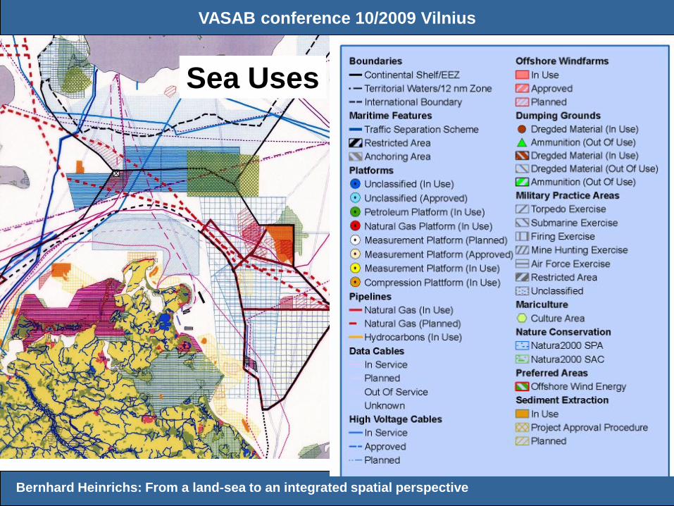
Sea Uses

Bernhard Heinrichs:
Reasons for
Maritime
Spatial
Planning:
• increasing density of sea uses
• new forms and new types of sea uses
• growing interchanges between land and sea uses
• climate change
• EU natura 2000 for sea areas

VASAB conference 10/2009 Vilnius
Bernhard Heinrichs: From a land-sea to an integrated spatial perspective
Contents
• 0. Introduction: Political objectives and requirements
• 1. Similarities and differences of MSP and TSP?
• 2. How to draw up a MSP?
• 3. How to integrate MSP and TSP ?
• 4. Conclusions and Recommendations

VASAB conference 10/2009 Vilnius
Bernhard Heinrichs: From a land-sea to an integrated spatial perspective
How to draw up a MSP?
• General Steps (PlanCoast Handbook, slightly changed):
• Step 1: Assessing the context and establishing a general framework for MSP
• Step 2: Drawing up a guiding vision
• Step 3: Analysis- Identifying issues and problems
• Step 4: need orientated stocktaking and mapping
• Step 5: Developing solutions for the problems identified
• Step 6: Drawing up a plan
• Step 7: Implementation
• Step 8: Evaluation

VASAB conference 10/2009 Vilnius
Bernhard Heinrichs: From a land-sea to an integrated spatial perspective
How to draw up a MSP?
• Specific steps with emphasis on legal procedures
• (example: Plan for German EEZ):
• - Announce planning intention; Enquire about stakeholder interests
• - Draw up 1.draft of spatial plan
• - Scoping than draw up environmental report
• - Consult on draft spatial plan and environmental report
• - Weigh up all interests amend draft spatial plan if necessary
• - Consult again those stakeholders whose interests are affected by the amendment
• - Draw up final spatial plan with a consolidated environmental statement
• - Spatial plan adopted and published as a statutory instrument

VASAB conference 10/2009 Vilnius
Bernhard Heinrichs: From a land-sea to an integrated spatial perspective
Priority areas for wind energy
(red)
no turbines in Natura 2000
areas
gates for electricity cables

Maritme Spatial Plan : Ex. German Baltic Sea ( MV )

VASAB conference 10/2009 Vilnius
Bernhard Heinrichs: From a land-sea to an integrated spatial perspective
Contents
• 0. Introduction: Political objectives and requirements
• 1. Similarities and differences of MSP and TSP?
• 2. How to draw up a MSP?
• 3. How to integrate MSP and TSP ?
• 4. Conclusions and Recommendations

VASAB conference 10/2009 Vilnius
Bernhard Heinrichs: From a land-sea to an integrated spatial perspective
Integrating land and sea EX: Greifswald Bay
• Informal conflict management via“ round table “
• Voluntary agreements between users and
environmentalists
• Zoning with physical + time component
• Results secured in statutory spatial plan

VASAB conference 10/2009 Vilnius
Bernhard Heinrichs: From a land-sea to an integrated spatial perspective
ICZM-planning process: Ex. Greifswald Bay
Requirement of nature protection and improvement of nature quality
Requirement of uses and potential for development
Analysis: Overlap of different use interests
Search of possible solutionsvia moderation
areas with no use conflicts areas with use conflicts priority for nature protection
Result: zonig/ use coordination
Stocktaking:
MO
DE
RA
TIO
N

VASAB conference 10/2009 Vilnius
Bernhard Heinrichs: From a land-sea to an integrated spatial perspective
List of stakeholders
Local user groups: sailors, surfers, anglers,
canoers, harbour operators
Tourism agency
Municipalities and regional authorities
Fishery authorities
Regional and local nature protection authorities
NGO´s: representatives of World Wildlife Fund
(WWF)

VASAB conference 10/2009 Vilnius
Bernhard Heinrichs: From a land-sea to an integrated spatial perspective
Requirement of uses and potential
for development:
Shipping routes/anchorage areas
Military practise areas
Cables (electricity, telecom) and pipelines
Sand/gravel extraction
Tourism (e.g. boat tourism)
Wind farms and connecting cables
Fishery and aquaculture

Plan Coast Meeting Constanta
2007
Bernhard Heinrichs: Development zoning in Baltic Sea
Bay areas
“Greifswalder Bodden”: Requirement of nature protection
habitats of fauna and flora
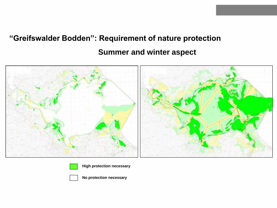
Bernhard Heinrichs: Development zoning in Baltic Sea
High protection necessary
No protection necessary
“Greifswalder Bodden”: Requirement of nature protection
Summer and winter aspect

VASAB conference 10/2009 Vilnius
Bernhard Heinrichs: From a land-sea to an integrated spatial perspective
ICZM +statutory plan

VASAB conference 10/2009 Vilnius
Bernhard Heinrichs: From a land-sea to an integrated spatial perspective
Contents
• 0. Introduction: Political objectives and requirements
• 1. Similarities and differences of MSP and TSP?
• 2. How to draw up a MSP?
• 3. How to integrate MSP and TSP ?
• 4. Conclusions and Recommendations

VASAB conference 10/2009 Vilnius
Bernhard Heinrichs: From a land-sea to an integrated spatial perspective
Selected Recommendations for integrated MSP
A Planning process and content
• Prepare Maritime Spatial Plans only where and when needed
• Collect data according to need
• Make full use of participative planning by applying informal tools
• Draw up the MSP together with a plan of the coastal zone if possible
• Use cross-sectoral coordination procedures (TIA including EIA) for projects

VASAB conference 10/2009 Vilnius
Bernhard Heinrichs: From a land-sea to an integrated spatial perspective
Recommendations: B Institutional aspects
• Do not create MSP-specific institutions - improve the use of existing ones
• Maritime Spatial Plans should be prepared by cross sectoral agencies– spatial planners as neutral agents should take the lead
• Care for political awareness-raising as MSP is more than a technical exercise – it is a political responsibility
• Secure political support to improve effectiveness of cross-border consultation

VASAB conference 10/2009 Vilnius
Bernhard Heinrichs: From a land-sea to an integrated spatial perspective
Recommendations:
C 3 basic rules for an integrated MSP:
• Keep areas available for future developments as conditions and needs change over time
• Consider that reserve areas or human activities may need to be shifted, or adapted over time as fish or birds will not be impressed by spatial plans, but move around as environmental conditions dictate.
• Last rule: keep it simple!

VASAB conference 10/2009 Vilnius
Bernhard Heinrichs: From a land-sea to an integrated spatial perspective
Can the experience of TSP be used for MSP?
Yes it can!
This gives spatial planners as neutral agents
a crucial role in drawing up MSPs.

Thank you very
much for your
attention!
Bernhard Heinrichs: Maritime spatial planning