friends of bidston hill wirral & north wales field archaeology
TRANSCRIPT

1
Friends of Bidston Hill
Wirral & North Wales Field Archaeology
Bidston Hill
Birkenhead, Wirral
An archaeological evaluation and assessment of the results
May 2011

2
Bidston Hill
Birkenhead, Wirral
An archaeological evaluation and assessment of the results
Prepared on behalf of the Friends of Bidston Hill
Tam O’Shanter Urban Farm
Bidston
CH43 7PD
By
Heather Butler, Local History Tutor
5 Shortfield Way, Upton, Wirral, CH49 9BB
&
Felicity Davies
Wirral & North Wales Field Archaeology
Wendigo 32 Pistyll
Milwr Holywell Flintshire CH8 7SH
Phone: 01352 719554
May 2011

3
Bidston Hill
Birkenhead, Wirral
An archaeological evaluation and assessment of the results
Contents
Summary
Acknowledgements
1 INTRODUCTION............................................................................................... 6
1.1 Project Background ......................................................................................... 6
1.2 Site Location, Topography and Geology........................................................ 6
1.3 Historical Background..................................................................................... 7-9
1.4 Previous Archaeological Work .......................................................................9
2 AIMS AND OBJECTIVES................................................................................ 9-10
3 METHODS...........................................................................................................10-11
3.1 Landscape and Earthwork Survey..................................................................10
3.2 Geophysical Survey...........................................................................................10
3.3 Desktop survey..................................................................................................10
3.4 Evaluation Trenches ........................................................................................11
4 RESULTS............................................................................................................. 11-12
5 THE FINDS.......................................................................................................... 12
6 DISCUSSION..................................................................................................... . 13-14
7 RECOMMENDATIONS.................................................................................... 14
8ARCHIVE............................................................................................................. 14-15
9REFERENCES..................................................................................................... 15
Figures
Figure 1: Site location, trench location and geophysical survey areas
Figure 2:.Ordnance survey map of 1912
Figure 3: Geological formation of Bidston Hill
Figure 4: Plan of Bidston Hill (not to scale) of positioning of rock carvings (photos to follow)
Figure 5: .ditto
Figure 6: Plan of semaphore signalling station
Figure 7: Timeline for dig site from January 1914
Figure 8: Tithe apportionment map of 1842
Figure 9: Parcel of land encompassing ‘the site’ conveyed on 28 May 1914
Figure 10: Google imagery showing boating lake at Gautby Road & the ‘site’
Figure 11: Surveillance point & central conifer
Figure 12: Channel around central area
Figure 13: Glass bottle from Trench II
Figure 14: ‘hot rock’ possible magnetite from Trench VII
Figure 15: possible lead shot from Trench VIII
Front cover: .Recording features on Trench I
Appendix 1: A community dig
Tables:
Table 1: Grid & Embankment levels with accompanying grid line survey
Table 2: Finds totals by trench
4
Bidston Hill
Birkenhead, Wirral
An archaeological evaluation and assessment of the results
Summary
During the summer of 2010, Felicity Davies (Wirral & North Wales Field Archaeology Unit) and Heather Butler, Wirral local history tutor were asked to investigate a small feature on Bidston Hill, situated near to the top car park of Tam O’ Shanter Urban Farm. Following an extensive volunteer training weekend, an army of enthusiastic trainee archaeologists set about investigating the said area over a period of 7 weekends. Over the course of investigations, volunteers were trained in various archaeological and surveying techniques as well as finds identification, washing and marking together with a history timeline session with a local history tutor and 3 visits to Wirral Archives, Canning Street, Birkenhead and a visit to Merseyside Maritime Museum archival collection.
5
Bidston Hill
Birkenhead, Wirral
An archaeological evaluation and assessment of the results
Acknowledgements
This programme of investigation, post excavation and assessment has been funded by the Friends of Bidston Hill, Wirral, an area of natural beauty owned, at present, by Wirral Borough Council. We would like to take this opportunity to thank the members of this group who assisted throughout with their enthusiasm and commitment, following on from their initial enquiries as to what the feature investigated represented. Sincere thanks to the Chairman, Professor Derek Knottenbelt in his support for this project.
Funding applications and immense support and enthusiasm were given by the Rangers at Tam O’ Shanter Farm. Thanks to John Jakeman, Senior Ranger, Nic Harding, Bidston Hill Ranger and Linda, not only for their commitment but also for the use of the workshop, mess room, activity room & numerous tools, wheelbarrows & cafe vouchers!
Historical investigation was conducted by Heather Butler, local history tutor. Wirral Borough Council’s archive service at Canning Street, Birkenhead, Wirral is an extremely valuable service and thanks are directed to them, particularly William Meredith, Senior Archivist, Francesca Anyon and the other extremely helpful archivists. This report was compiled by Heather Butler & Felicity Davies. A tremendous amount of historical research, oral memory & interpretation was provided by Tony Roberts, Glyn Holden, Elizabeth Davey, Mike Kemble, Mike Curtis, Terry McKenna, Joan & Eric Wheeler & Brian Sinton.
The programme of work also benefited from a useful and interesting session on historical chronology by Joanne Dickson. The team of volunteers dealt with finds care.
The excavation was led by Felicity Davies of Wirral & North Wales Field Archaeology with assistance by Kevin Cootes, Martin Doughty, Robert Manson & David. Alan D’ Henin undertook the site levels and assisted with post-excavation analysis whilst Philip Moy scanned surfaces by metal detector.

6
Bidston Hill
Birkenhead, Wirral
An archaeological evaluation and assessment of the results
1. Introduction
1.1 Project background
1.1.1 Contact was made by (via local history students), the Ranger Service for Bidston Hill with a query regarding features on the Hill (hereafter ‘the site’). The Rangers had been asked many times by members of the public about what they were and the Rangers had been unable to answer. After seeing the features it was decided that a community dig would be a good idea, thereby involving the community and hopefully enhancing local pride and knowledge as to local history [Appendix 1].
1.1.2 Heather Butler, local historian, Tutor in local history and YAC leader agreed to help organise the dig. It was decided that we would run 2 day schools for people who wanted to take part in the dig. The idea being to give the volunteers a very basic grounding in the main ideas of archaeology and to provide an introduction to practical work they would be undertaking. The day schools were an unqualified success, following this; a date was fixed for the commencement of work.
1.1.3 This report documents the results of archaeological survey and evaluation undertaken and presents an assessment of the results of these works.
1.2 Site location, topology & geology
1.2.1 The site is located near the ancient village of Bidston and within the area known as Bidston Hill [Figure 1] and centred on Ordnance Survey Number SJ292 891. Bidston Hill is part of a sandstone ridge that runs from the tip of the Wirral Peninsular to about the middle [Figure 2]. It rises above the surrounding plain. The area around Bidston Hill is very low lying and over time the sea level has risen and fallen quite dramatically. The ridge of Bidston Hill overlooks the flat plain of the Wirral and is therefore visible for a very long way providing ships approaching Liverpool with a landmark for the mouth of the River Mersey.
1.2.2 The underlying geology of the site is boulder clay overlain with a Keuper
basement bed with alluvium silts closer to the River Dee (Wirral Local Studies Group) [Figure 3].

7
1.3 Historical Background
1.3.1 Along the top of the Wirral peninsular facing into the Irish Sea was/is a submerged forest visible at low tide well into the 20th century, the remnant of a great forest that stretched almost to Chester in early medieval times.
1.3.2 Also along this stretch of coast is the early settlement of Meols which is now covered by sand. This was probably founded as a port in Roman times for the transport of goods to Chester (Deva) as it would have been much easier to transport goods by sea rather than overland. The port of Meols continued into the medieval period. The presence of pilgrim tokens tells us that Meols became a stopping place for pilgrims probably visiting the shrine of Our Lady of Hilbre. Much is written of Meols elsewhere. The definitive report ‚Meol.s, The Archaeology of the North Wirral Coast‛ by David Griffiths, Robert A. Philpott, Geoff Egan. Published by Oxford University School of Archaeology, Monograph 68, Institute of Archaeology, University of Oxford.
1.3.3 There is known to be a large Romano/British settlement at Irby on the Wirral which of course has continued. There are probably many more waiting to be discovered.
1.3.4 The village of Bidston lies in the lee of the Hill facing north. The village church dedicated to St. Oswald has its foundation in the 12th century, but was much improved in the Victorian era. The village is now designated a conservation area.
1.3.5 Bidston Hill is one of the highest points on the Wirral covering 100 acres of heathland and woodland, containing mysterious rock carvings and historic buildings. It was intended at the very outset to reserve this area of natural beauty for the recreation and enjoyment of the public and also a haven for wildlife.
1.3.6 There is, arguably, some evidence of prehistoric activity on the Hill in the form of rock carvings [Figure 4] in the form of the so-called Sun Goddess and a horse [Figure 5], arguably a depiction of the Celtic Goddess, Epona. Other rock carvings can be seen on the vertical rock face just south of the Observatory building. The map, Bidston Hill (not to scale) shows the position of these carvings.
1.3.7 Over time there have been many farms and estates on the Hill, including a medieval deer park which extended for 7 miles, created in 1407, enclosed by a wall known as Penny-a-day Dyke in order to create a deer park for private deer hunting. The Kingston Survey of 1665, created by Thomas Taylor reveals the extent of the deer park into surrounding hamlets.
1.3.8 The ‘cock pit’ is an intriguing feature on the Hill, found at the very northern end, near to Bidston Hall. It consists of a narrow circular trench,
8
approximately one foot wide and one foot deep and measuring 22 feet in diameter cut into the bare sandstone surrounded by the dominant gorse bushes on the Hill. Whilst many feel this is a local cock-fighting site it may also represent the remains of a small gorse mill where gorse was crushed for animal feed (Neilson 1935).
1.3.9 The brick built tower mill, still in situ, replaced a wooden peg mill which had been destroyed by fire in 1791. This had been used to grind corn into flour for 75 years up until 1875. There are local accounts appertaining to accidents at the mill. Unfortunately one miller was struck by the heavy wooden sail and killed. In 1894 Mr. R.S. Hudson contributed monies for the windmill to be restored, following a period of neglect owing primarily to the introduction of steam powered mills (Bidston windmill, undated).
1.4 In 1763 a signal station was operable on the hill, eventually consisting of over
100 flagpoles sited all over the ridge of the hill. This system was utilised to send messages to Liverpool merchants of incoming ships. There is a remaining visible flagpole hole, approximately 30 yards north of the windmill. During the mid 19th century there was a semaphore station with flags for all the shipping lines sailing to and from the Port of Liverpool [Figure 6].
1.4.1 In 1771 the first lighthouse was built forming part of the semaphore signals along the North Wales coast. The present lighthouse was constructed in 1873; its height enabled it to be seen in conjunction with the lighthouse on Leasowe bay.
1.4.2 On the Hill now is the defunct Proudman Institute which comprised Bidston
Observatory, built in 1866. The Proudman Institute was able to calculate the magnetic north pole and plot it over time, and also tidal predictions worldwide. It closed down several years ago and its function moved to the University of Manchester. The building is currently converted into apartments. The Observatory would, each day at about 1.00pm fire the ‘One O Clock gun’ on Birkenhead Dock by a series of switches. This gun and telescopes were given to National Museums, Liverpool in 1962.
1.4.3 The Hill is now administered by Wirral Borough Council as a leisure facility and a natural resource. During the Victorian era there were tea rooms and walkways created, and in honour of the visit of King George V to open the Mersey Tunnel, a carriage path now called King George Way was laid out.
1.4.4 The attached document prepared by volunteer, Alan D’ Henin provides a breakdown of initial discoveries made, together with an Appendix A & B. [Figure 7].
1.4.5 On analysis of the minutes of the Committee of Management for Bidston Hill spanning 1904 to 1929 there were various references to a pond and/or boating lake in the area of the feature in question. Indeed, it became apparent that preparations were being made for the visit of King George to Wirral on 25th

9
March 1914, although there are no further references within this source as to the result of the construction and whether in fact it was completed.
1.4.6 Various maps were consulted which highlighted the parcels of land purchased by the Corporation at intermittent dates spanning 1914 to 1925. There were six purchases of land – (1893) 46 acres, (1894) 24 acres, (1897), 37 acres, (1900) 4 acres & (1914) 8 acres (Wirral Local Studies Group, undated). The tithe apportionment map of (1842) also highlights the non-existence of the site [Figure 8] whilst [Figure 9] shows the parcels of land, including ‘the site’, to Wirral Council on 28th May 1914.
1.4.7 The Report of the Town Clerk to the Finance Officer dated 16th June 1892 concerns Bidston Hill park and the ...’emphasis on preservation for the public...means of healthy recreation and enjoyment to large numbers of Birkenhead residents’. Reference is made to the ‘crown of Bidston Hill as a public space’ (Wirral Local Studies Group, undated).
1.4.8 It is with great interest that in 1886 the landowners, the Vyner family proposed to build and establish the Bidston Hill Estate; a private housing estate. Whilst the bulk of this project did not go ahead and only a small number of properties were built, the cartographic evidence clearly reveals that much of the Hill would have been covered by private housing, including in the vicinity of the ‘site’ (Cooper, date unknown).
1.4.9 The scheme is again given some consideration in 1903, albeit on a more modest scale. It is apparent again from the historical source for this development that construction was very much intended for the southern and western part of the Hill. Birkenhead and Wallasey would very much have been developing ports at this period in time and Robert Cooper suggests they may have been ‘avoiding the less salubrious’ views of industrial growth around Birkenhead & Wallasey Pool.
1.4 Previous archaeological work
1.4.1 There is no recorded evidence of any previous archaeological work in the area of this site. There are no scheduled ancient monuments (SAM) or listed buildings on the site. Full access to the Historic Environment Record (HER) formerly Sites & Monument Record has been made.
2. Aims and Objectives
2.1. An initial feasibility study was undertaken which questioned the reasons for
this investigation, not only in terms of public funding but in relation to what could be learnt from this site.
2.1.1 A project design for a community archaeological project was compiled providing full details of the research aims and methods. A brief summary is provided here.

10
2.1.2 The aim primary of the project was to investigate the hypothesis the following specific research questions: - Did the site represent:-
(a) Part of the old road leading to the Observatory?
(b) Related to the old flag system and quarry?
(c) Relationship to Flaybrick (if any) and 1407 deer park?
(d) A further ‘cock-pit’?
(e) Relationship, if any to Vyner’s 1886 plans to develop area for housing?
(f) Any relationship to a World War One prisoner of war camp of 1917 based somewhere in the locality?
3. Methods
3.1 Landscape Survey 3.1.1 A landscape survey and analysis of the cartographic evidence was undertaken
by Felicity Davies & Alan D’Henin.
3.2. Geophysical Survey 3.2.1 Given the obvious limited stratigraphy & thin soil layer on the site, it was
deemed unnecessary, in this instance to conduct a geophysical survey. A grid line survey was prepared by Alan D’ Henin and tied into the Ordnance Survey grid. Table 1 sets out grid and embankment levels taken together with grid line survey referred to in this spreadsheet.
3.3 Desk top survey
3.3.1 Desktop survey indicated a mid 19th century date with some possibility of earlier provenance. It was agreed that conducting a geophysical survey would probably not be helpful as soil cover was extremely thin. After a close inspection of visible features it appeared very likely that it was a multi phased site, with surrounding stonework being early 20th century.
3.4 Evaluation Trenches 3.4.1 In all, 8 trenches were opened. Some of them ended up running together, as
can be seen from the diagrams and plans.
3.4.2 The trenches were excavated by hand using spades. No machines were used. All trenches were excavated under constant archaeological supervision and ceased at the identification of significant archaeological remains, or where natural geology was encountered first. All trenches were cleaned by hand and archaeological deposits investigated.
3.4.3 The excavated up-cast was scanned by metal detector, Philip Moy.

11
3.4.4 All archaeological deposits were recorded using pro forma record sheets with a unique numbering system for individual contexts. The BAJR Guide 23 & Practical Guide prepared by David Connolly in March 2009 was referred to and utilised for this purpose, which includes the basic conventions for planning. All archaeological features and deposits were planned at a scale of 1:20 with sections drawn at 1:10. All principal strata and features were related to the Ordnance Survey datum.
3.4.5 A full photographic record of the investigations and individual features was
maintained utilising colour transparencies. The photographic record illustrated both the detail and general context of the archaeology revealed and the Site as a whole.
3.4.6 At the completion of the work, trenches were not reinstated using the
excavated soil, pending completion of an educational programme.
3.4.7 A unique site code (BID 10) was agreed prior to the commencement of work. The work was carried out between 24th July 2010 & 29th August 2010. The archive and all artefacts were subsequently transported to the home of Felicity Davies in Shotton, Flintshire where they were processed and assessed for this report.
4. Results
4.1. Details of individual excavated contexts and features, the summary of the landscape and earthwork survey and details of artefactual assessments, are retained in the archive. Summaries of the excavated sequences can be found in
4.1.1 As work progressed several factors became apparent.
4.1.2 Firstly, that a huge amount of work, effort and time had been expended to the extent that the original enterprise was most likely a corporate plan rather than a private venture.
4.1.3 Secondly, that a great effort had been made to ensure that the central part of
the site was kept as dry as possible. Deep drainage channels had been cut into the rock sides of the site to drain rainwater into the other side of the encircling path. The spreadsheet of levels and accompanying survey grid at Table 1 show the fall of the site towards the perimeter channel and the carved channel in Trench I. That area is very marshy, and the site itself is remarkably well drained; and nothing was finished. The early 20th century stone edging that goes part way round the site is also unfinished. From Wirral archives it was discovered that permission had been granted to use stone from the medieval deer park wall. Evidently there had been some debate about using the site as a model boating lake. The boating lake was eventually built elsewhere on Gautby Road, Bidston, Wirral. [Figure 10] shows the relationship between the ‘site’ and Gautby Road.
4.1.4 A part of the stone cutting has been done by hand with a chisel and other areas have been worked with presumably a rock drill. There are also at least 2 precisely cut ordnance survey marks also indicating how important it was that the site be carefully and exactly worked [Figure 11].

12
4.1.5 There is a central ‚platform‛ which now has a Scots Pine tree growing in it. The tree has split and broken down the stone around it, so it is unlikely it was deliberately planted. The Ranger – Mr Nic Harding informed me that the tree is approximately 160 years old. Therefore, the surrounding site would predate the growth of the tree. [Figure 12] shows a channel cut around the central area.
4.1.6 The site has almost no stratigraphy, soil cover consisting of a layer of humus followed by a thin layer of sandy soil derived from decayed sandstone and leaf mould. The exception to this is the banked edges of the site. A section was taken through the bank to determine the construction. It was found that a kerb of stones had been set into a layer of sandy clay. Below this was a layer of the local sandy soil, then onto natural stone. As the soil cover is so very thin no section drawings were taken.
4.1.7 It is possible that the stones that have been set in the banked edges of the site have been placed rather later than the rest of the site. The style of the settings strongly suggests typical garden features of the Victorian/Edwardian era. As there is mention of the construction of a model boating lake on Bidston Hill in the Wirral archives, and also mention of permission to use the stones from the medieval deer park it is possible that the site had been looked at with a view to adapt it to the purpose of the boating lake. However, as with everything else on the site, it was never completed.
5. The finds
5.1 There is no firm dating evidence from the finds to assist us in the reason for construction or date of the feature albeit there a small number of artificially created surveillance points on site, for example in Trench I, suggesting a planned construction [Figure 11]. These circular features do not match the only remaining semaphore flag pole hole and therefore may not be connected to this feature. The circular feature was constructed in a rock drill and hand cut fashion and pre-dates the in-situ centre conifer which has been reliably dated to circa 160 years old.
5.1.1 As the soil layer is very thin with almost no stratigraphy and is also highly acidic, the finds were limited with very few metallic items recovered.
5.1.2 However, the finds were varied and some were quite interesting. They told us nothing at all about the origin of the site, but a lot about how people used the place. For example: people had been camping and picnicking – we found a tent and the fragments of cups and a teapot, lots of broken glass, empty packets of crisps and biscuits.
5.1.3 Unsurprisingly, there was a dog lead, with the metal parts eaten away by the acidic soil, there are houses very nearby, and the Hill is the ideal place to take a dog for a walk. Children had been playing there – balls of various types and even a child’s shoe. A woman’s purse and a docker’s work pass were also recovered.

13
6. Discussion
6.1 In terms of the material culture, the majority of the items highlight the social use of the site over the last 100 years, particularly crisp packets, tenting material, dog leads and locally manufactured glass bottles. The documentary evidence supports various purchases of the Hill dating from 1893 to 1914, a total of 119 acres, resulting in a ‘Bidston Hill purchase fund’ wherein many notable local contributors may be identified, with the intent of providing recreation and leisure ground for the people of Birkenhead. Indeed, there is a further application for extension of land in 1907 as a permanent memorial of the late Mr. Edmund Taylor who had made great endeavours to purchase recreation ground. Mr. Taylor is remembered in ‘Taylor’s Wood’, the site of the feature.
6.1.1 The documentary evidence supports the fact that Bidston Hill has been the source of contention for many years, providing enjoyment and subsistence for some. For example, in the early 20th century there are references within the Bidston Hill Committee minutes of people stealing gorse, ferns, plucking heather & ‘throwing lighted matches about’; each receiving fines. There is a poignant reference to three children ‘having been detected on 13th instant gathering bluebells in the wood and that they had been summoned for it. Mr. Fearnley attended and explained that he had no doubt a conviction would be obtained’, a severe punishment perhaps for something so trivial?
6.1.2 The piece of magnetite or ‘hot rock’ in Trench VII [Figure 14] was felt to be extremely similar to this common mineral, being coloured black to silver although its magnetism was generally weak. Nothing similar was discovered on site. Magnetite is a valuable source of iron ore and was discovered in an area which may questionably have been used at some point for burning or heating products.
6.1.3 Trench VIII produced what was felt, arguably to be a piece of lead shot [Figure 15], bearing the same characteristics in shape & design. Comparisons were made against other pieces of lead shot provided by a Metal Detector and whilst there were similarities, the weight of this lead shot was not comparable.
6.1.4 Remarkably, some red flint was discovered in Trench V which together with the presence of extensive layering of sandstone reveals evidence for the age of Bidston Hill, spanning millions of years.
6.1.5 The temperance cafe which was also located in the vicinity of this feature may also suggest why there was a vast collection of glass [Figure 13]. This part of the Project’s historical research is ongoing.
6.1.6 It is with, perhaps some doubt that the site represents a First World War prisoner of war camp and there is no archaeological evidence to suggest so. Hansard refers to a camp on the west side of Bidston Hill, all the huts being on concrete blocks, although in 1918 it is dismantled (including the concrete foundations), only to be reinstated again as a camp for German prisoners of

14
war. It may be that prisoners were exercised on the Hill and worked in the area of the vicinity of the archaeological site. Unfortunately, there is no archaeological evidence to support this.
6.1.7 In the Liverpool Mercury dated 1838 there is a report of an invention by Lieutenant Webster of a barometer [Figure 16]. This barometer was to be sited on Bidston Hill overlooking the Port of Liverpool. The idea was that another one would be placed at Holyhead. Readings would be taken at both Holyhead and Bidston, and then transmitted to each other. The reading would be put on the barometers so that a ships’ captain in Liverpool or Holyhead could take a reading and know what the weather was like in the Irish Sea. Apparently, there had been many shipwrecks once ships were past the ‚rocks‛ (New Brighton/Seacombe) because the captain could not know what the conditions were like in the open sea. Standing on the edge of the site looking towards Liverpool it can be easily observed that if modern buildings and trees were removed there would be a clear view over to Liverpool.
6.1.8 The dimensions of the barometer and the requirements fit very well with the site on Bidston Hill, as does the age deduced from a Scots pine tree growing out of the central platform. The Ranger (Mr. Nic Harding) has estimated the age of this tree to be about 160 years old. As the barometer was never put in place and the site was never finished, it seems a fairly reasonable conclusion that the site could have been prepared for the placement of the barometer.
6.1.9 In the spring of this year (2011) an inspection was made of the land on the other side of the path to the site. The remains of an encircling wall were found. As this area is always wet and very marshy it is possible that rainwater is drained from the ‚barometer site‛ into this. As there is an encircling wall it is also possible that this is the site for the proposed boating lake. It is proposed that this possibility is explored in the near future.
7. Recommendations 7.1.1 Given the limited nature of the results of the evaluation, no further analysis is
deemed appropriate. A copy of this report will be submitted to the Cheshire Sites and Monuments Record, and the results may also be used by the Friends of Bidston Hill in their continuing investigation of the site on Bidston Hill. It is recommended that a summary of the results of the evaluation is submitted as a short note for inclusion in the annual round-up of investigations and excavations in the Journal of the Chester Archaeological Society & the Journal of Merseyside Archaeological Society.
8. Archive 8.1.1 The excavated material and archive, including plans, photographs and written.
Records will be held at Tam O’ Shanter Farm, Boundary Road, Bidston, Wirral under the project code Hill 1 and site code BID10. It is intended that a copy of the archive should ultimately be deposited with the Museums Service,

15
although in the interim can be retained by the Friends of Bidston Hill to be used in their continued research, albeit only if this further research is deemed appropriate by them. An ‘initial’ assessment of findings was lodged with Sarah Jane Farr, Merseyside Archaeological Officer, Merseyside Archaeological Advisory Service (for Knowsley, Liverpool, St. Helen’s, Sefton, and Wirral), Dock Traffic Office, NML, Albert Dock, Liverpool, L3 4AX on 16th December 2010.
9. References
Author & date unknown, Discovering Wirral’s Countryside, Bidston Hill 1 (A brief history. Author and date unknown, Discovering Wirral’s Countryside, Bidston Windmill. Bidston Hill Committee of Management Minute Book, Wirral Archives, reference B/026/1. Chronology of Bidston from 1975. Birkenhead Reference Library, Item 48, Box 1 of 2.
Glover, B. (2010) History of the Atlantic Cable & Undersea Communications from the first submarine cable of 1850 to the worldwide fiber optic network. Liverpool - Holyhead Semaphore Telegraph.
Retrieved May 25 2011, from the World Wide Web:
http://atlantic-cable.com/Article/Holyhead-Liverpool/index.htm
Hansard Deb 18 November 1918 Volume 110 cc3211-2W3211W.
Neilson, H.B. (1935) Auld-lang syne, (Willmer, Birkenhead). p.228.
Report of Town Clerk to Finance Officer (1891-1892), Birkenhead Reference Library, Item 1, Bidston Hill, Hall & Village, Box 1 of 2.
Robert Cooper, (date unknown)\ Dissertation.
Wirral Local Studies Group, (undated), A study of Bidston Hill, Birkenhead Reference Library, Item 56, Box 2 of 2.

16
Table 2: Finds
Trench Item Comments
I Piece of wood/handle
Crushed coke can
2 pieces of red ceramic
Glass
Wood charcoal
Corroded metal
Textiles
Monster munch packet (empty)
20th century
marked ‘Birkenhead Liverpool
Brewery’ with a ‘Dutch’ boy
imprinted on the underside
Brown ‘tent’ material possibly
date to the turn of the 20th
century
II Leather dog lead
Corroded metal
Piece of leather
Ceramic pot
Bent spoon
Glass fragments
Crisp packets (empty)
Bottle complete with stopper
Fragments of glass
Metal fixings completely
corroded away
marked ‘Caine Chemist’
Birkenhead [Figure 13 ]
marked ‘Liverpool’
III Sterile
IV Pieces of ceramic
Fragments of white vitrified
ware
Trench drawings attached &
referred to as [Figure 17]
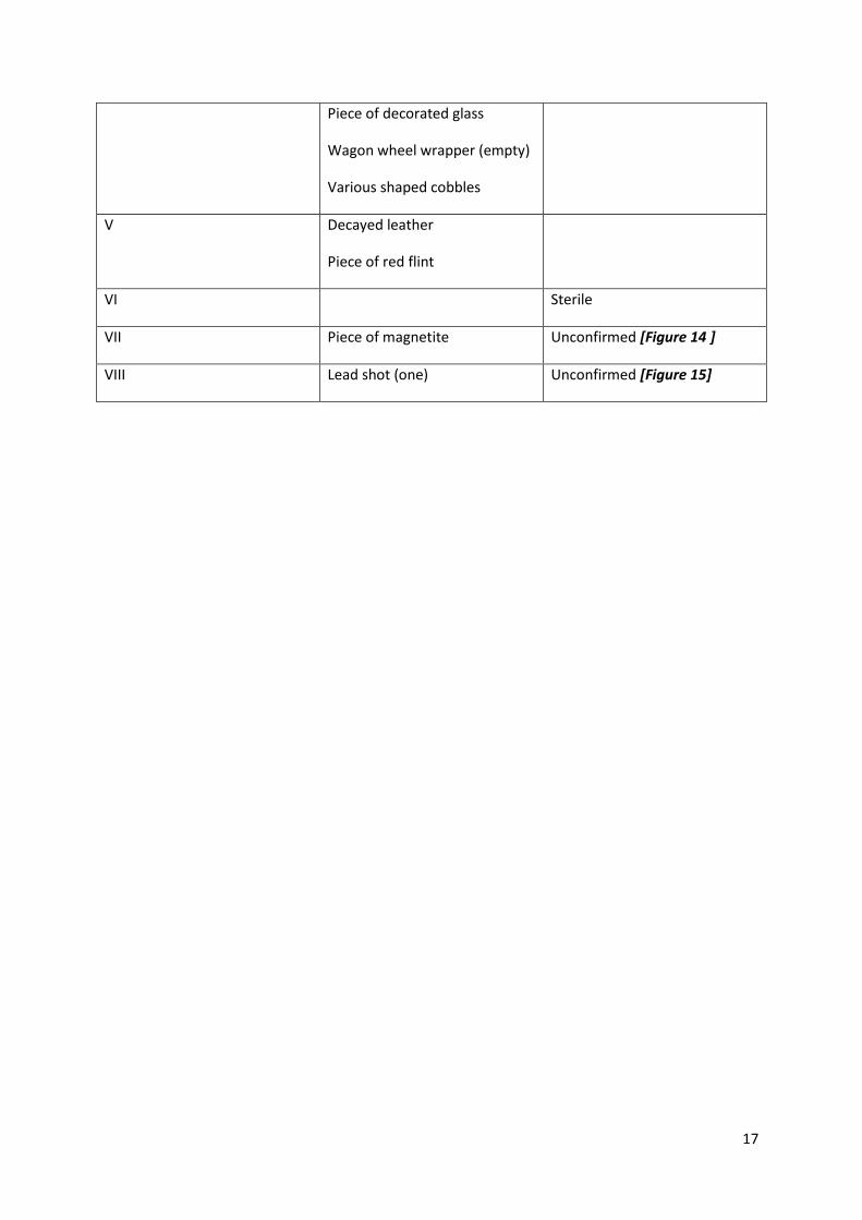
17
Piece of decorated glass
Wagon wheel wrapper (empty)
Various shaped cobbles
V Decayed leather
Piece of red flint
VI Sterile
VII Piece of magnetite Unconfirmed [Figure 14 ]
VIII Lead shot (one) Unconfirmed [Figure 15]