friday merapi volcano phreatic eruption, central java ... · merapi volcano phreatic eruption,...
TRANSCRIPT
Merapi Volcano Phreatic Eruption,Central Java Province, Indonesia
Flash Update No. 04
FRIDAY25 MAY 2018
10:00 UTC+7
DATA SOURCES
AHA Centre Disaster Monitoring & Response System (DMRS);
Pacific Disaster Center (PDC Global); National Disaster
Management Authority of Indonesia (BNPB); Centre of
Volcanology and Geological Hazard Mitigation of Indonesia;
Meteorological (PVMBG), InaRISK, Magma Indonesia,
Meteorological, Climatological, and Geophysical Agency
(BMKG)
© 2018 AHA Centre.
All rights reserved.
You are receiving this email
because you are registered
in our distribution list.
Our mailing address is:
AHA Centre,
GRAHA BNPB 13th Floor,
Jl. Raya Pramuka Kav. 38,
Jakarta 13120 Indonesia
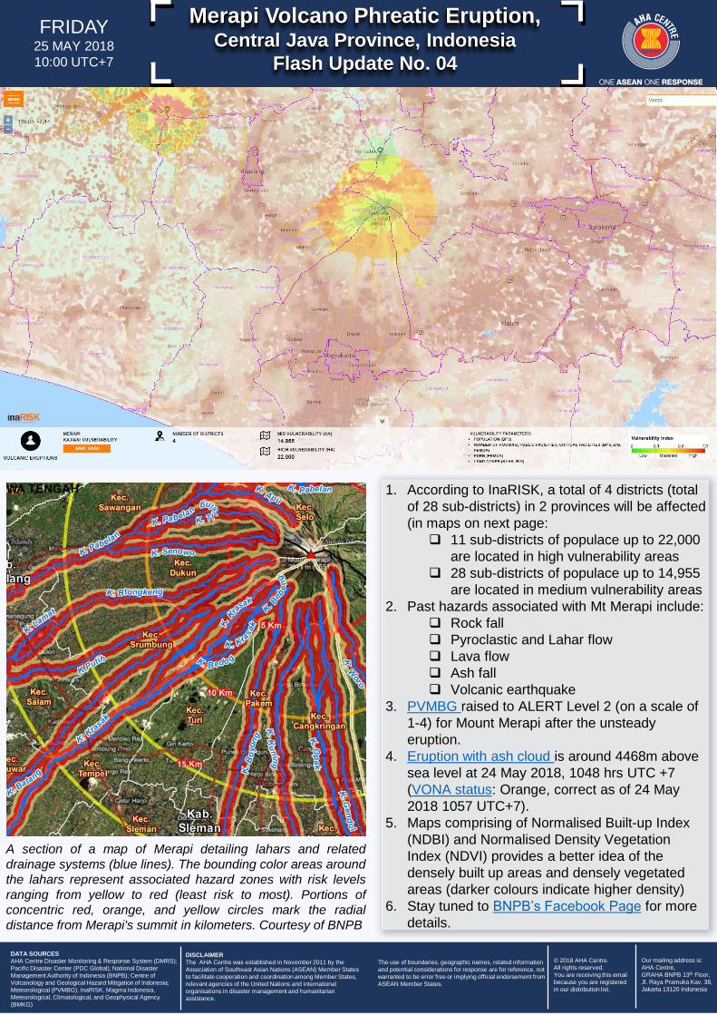
1. According to InaRISK, a total of 4 districts (total
of 28 sub-districts) in 2 provinces will be affected
(in maps on next page:
11 sub-districts of populace up to 22,000
are located in high vulnerability areas
28 sub-districts of populace up to 14,955
are located in medium vulnerability areas
2. Past hazards associated with Mt Merapi include:
Rock fall
Pyroclastic and Lahar flow
Lava flow
Ash fall
Volcanic earthquake
3. PVMBG raised to ALERT Level 2 (on a scale of
1-4) for Mount Merapi after the unsteady
eruption.
4. Eruption with ash cloud is around 4468m above
sea level at 24 May 2018, 1048 hrs UTC +7
(VONA status: Orange, correct as of 24 May
2018 1057 UTC+7).
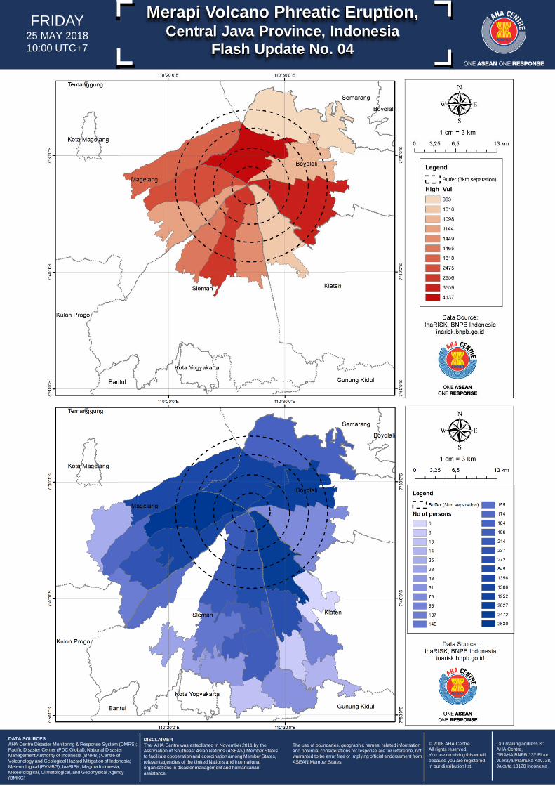
5. Maps comprising of Normalised Built-up Index
(NDBI) and Normalised Density Vegetation
Index (NDVI) provides a better idea of the
densely built up areas and densely vegetated
areas (darker colours indicate higher density)
6. Stay tuned to BNPB’s Facebook Page for more
details.
A section of a map of Merapi detailing lahars and related
drainage systems (blue lines). The bounding color areas around
the lahars represent associated hazard zones with risk levels
ranging from yellow to red (least risk to most). Portions of
concentric red, orange, and yellow circles mark the radial
distance from Merapi's summit in kilometers. Courtesy of BNPB
DISCLAIMER
The AHA Centre was established in November 2011 by the
Association of Southeast Asian Nations (ASEAN) Member States
to facilitate cooperation and coordination among Member States,
relevant agencies of the United Nations and international
organisations in disaster management and humanitarian
assistance.
The use of boundaries, geographic names, related information
and potential considerations for response are for reference, not
warranted to be error free or implying official endorsement from
ASEAN Member States.
Merapi Volcano Phreatic Eruption,Central Java Province, Indonesia
Flash Update No. 04
FRIDAY25 MAY 2018
10:00 UTC+7
DATA SOURCES
AHA Centre Disaster Monitoring & Response System (DMRS);
Pacific Disaster Center (PDC Global); National Disaster
Management Authority of Indonesia (BNPB); Centre of
Volcanology and Geological Hazard Mitigation of Indonesia;
Meteorological (PVMBG), InaRISK, Magma Indonesia,
Meteorological, Climatological, and Geophysical Agency
(BMKG)
© 2018 AHA Centre.
All rights reserved.
You are receiving this email
because you are registered
in our distribution list.
Our mailing address is:
AHA Centre,
GRAHA BNPB 13th Floor,
Jl. Raya Pramuka Kav. 38,
Jakarta 13120 Indonesia
DISCLAIMER
The AHA Centre was established in November 2011 by the
Association of Southeast Asian Nations (ASEAN) Member States
to facilitate cooperation and coordination among Member States,
relevant agencies of the United Nations and international
organisations in disaster management and humanitarian
assistance.
The use of boundaries, geographic names, related information
and potential considerations for response are for reference, not
warranted to be error free or implying official endorsement from
ASEAN Member States.