freshwater fisheries annual report 2017 · scott catton, kyle civalier, luke diglio, maria berezin,...
TRANSCRIPT

i
Investigations and Management
of New Jersey’s
Freshwater Fisheries Resources
2017
State of New Jersey
Division of Fish and Wildlife
Bureau of Freshwater Fisheries

ii

i
Investigations and Management of
New Jersey’s freshwater fisheries
Resources
2017
Including
Sport Fish Restoration Grant F-48-R
Job Performance Reports Segment 28
(November 2, 2016 – December 31, 2017)
and
Final Reports
March 2018
New Jersey Department of Environmental Protection
Division of Fish and Wildlife
Bureau of Freshwater Fisheries
This grant was paid for by fishing license sales and matching Dingell-Johnson/Wallop-Breaux
funds available through the Federal Sportfish Restoration Act.

ii

iii
State of New Jersey
Philip D. Murphy
Governor
Sheila Y. Oliver
Lt. Governor
New Jersey
Department of Environmental Protection
Catherine R. McCabe
Acting Commissioner
Rich Boornazian
Assistant Commissioner
Natural and Historic Resources
Division of Fish and Wildlife
Larry Herrighty
Director
Dave Golden
Acting Assistant Director, Operations
iv
BUREAU OF FRESHWATER FISHERIES
Research and Management Unit
Lisa Barno
Chief
Shawn Crouse
Principal Fisheries Biologist
Pat Hamilton
Principal Fisheries Biologist
Christopher Smith
Principal Fisheries Biologist
Mark Boriek
Principal Fisheries Biologist
Ross Shramko
Senior Fisheries Biologist
Scott Collenburg
Senior Fisheries Biologist
Eric Boehm
Assistant Fisheries Biologist
Charles Sedor
Technician II
Elizabeth O’Neill
Analyst Trainee
With the assistance of:
Scott Catton, Kyle Civalier, Luke Diglio, Maria Berezin,
Emily Powers, Justin Rozema, and Scott Ward
New Jersey’s Freshwater Research and Management activities are funded entirely
by New Jersey’s licensed anglers. These activities benefit the state’s 8 million
residents by protecting and assessing New Jersey’s vital freshwater resources.
Clean water for fish means clean water for us and generations to come

v
TABLE OF CONTENTS
INTRODUCTION
Highlights for 2017 ……………………………………….….….…………………... 1
Bureau of Freshwater Fisheries …………………………..….….……………….….. 6
Map of Fisheries Management Regions……………………...……………………… 8
Funding ……………………………………………………………………………… 9
2017 FIELD SAMPLING LOCATIONS
Map of Field Sampling Locations ..……………………….……………….……..….. 11
List of Field Sampling Locations by Funding and Projects ……….………………… 12
COLDWATER FISHERIES
Inventory of Trout Production Streams………………………………………………. 23
Lake Trout Population Assessment ………………………………………………….. 25
Landlocked Salmon………………………..…………………………………………. 28
Stocked Trout Movement Study in the Flat Brook C&R Area: Preliminary Findings.. 29
Stream Temperature Monitoring ……………………………………………………. 32
Trout Stocking Allocations ………………………………………………………….. 37
Trout Waters with Special Regulations…..………………………………………….. 39
Wild Trout Stream Regulation Assessment and Development………………………. 44
Wild Brook Trout Assessment ………………………………………………………. 47
Protection and Restoration of Inland Fisheries and Aquatic Habitats: Coldwater…… 51
COOLWATER / WARMWATER FISHERIES
Coolwater Fisheries Management….…………………………..……….……………. 62
General Fisheries Surveys………….…………………………..……….……………. 66
Lake Inventories………...………….…………………………..……….……………. 67
Warmwater Fisheries Assessments via Electrofishing………………………………. 68
Warmwater Fisheries Assessments / Reproduction Checks /
Native Fishes via Seining………………………………………………… 85
Protection and Restoration of Inland Fisheries and Aquatic Habitats: Warmwater… 101
ANADROMOUS FISHERIES
Anadromous Fisheries Assessment ……………………………………………..……102
Protection and Restoration of Inland Fisheries and Aquatic Habitats: Anadromous... 113
NATIVE SPECIES
Status Evaluation of Native Freshwater Fishes……………………………………… 114
State Wildlife Action Plan …….……………...…………………………………….. 115
Native Species Data Collection Efforts……………………………………………… 116
Protection and Restoration of Inland Fisheries and Aquatic Habitats: Native Species 119
INVASIVE SPECIES
Aquatic Invasive Fishes Management ………………………………………….…… 120
Aquatic Invasive Plant Management …………………….………………………….. 126

vi
FISH HEALTH
Cyanobacteria………………..…………….………………………………………… 127
Drought Watch/Warning……..…………….………………………………………... 128
Fish Contamination.……………………..…………….…………………………….. 129
Fish Kill Investigations….……………….…….…………………………………..... 130
Fish Salvages ………………………………….…………………………………...... 134
SURFACE WATER CLASSIFICATION
Surface Water Classification Assessments………………….……………….…........ 136
Stream Assessments for Surface Water Classification……………..………...…...… 136
Lake Assessments for Surface Water Classification………………………..…...….. 143
ANGLER USE ASSESSMENT
Angler Surveys ……………………………………………………………………… 144
Trout Angler Logbook Program ……………………………………………….…… 149
INFORMATION AND EDUCATION
Division of Fish and Wildlife Mobile Trailer......………………………………..….. 151
Professional Meetings/Conferences ……………………………………………..….. 151
Public Presentations ……………………………………………………….….…….. 152
Public Events …………………………………………………………….…….…… 152
OTHER FISHERIES RELATED ACTIVITIES
Permits ……………………………………………………………………….……... 155
Wildlife Management Area Fishing Tournament Permits ……………….….……… 156
Database Management – FishTrack ………………………………………….…….. 156
LITERATURE CITED ………………………………………………………….……... 157
APPENDICES
A 2017 Stream Electrofishing Survey Data
B Field Sampling Protocols – Lake Profiles and Wadeable Streams
C Habitat Assessment Datasheets
– High Gradient Streams (w/regional modifications)
– Low Gradient Streams (w/regional modifications)
D List of New Jersey Freshwater Fish Species
E Stocked Trout Movement Study in the Flat Brook C&R Area: Preliminary Findings
F Opening Day Trout Angler Survey Report (2017)
G Assessment and Management of New Jersey’s Stocked Coolwater Fishes

1
INTRODUCTION
Highlights for 2017
NJ Division of Fish and Wildlife’s Bureau of Freshwater Fisheries (BFF) is responsible for the
management of New Jersey’s freshwater fisheries resources. BFF activities include many facets,
including fish culture and managing wild and stocked fish populations, protecting and enhancing
their habitats, and educating the public. In 2017 the BFF conducted a total of 199 fisheries
surveys, at 118 waterbodies, to address a variety of recreational and resource management needs,
including response to emerging fisheries issues. A total of 53 rivers and streams and 65 ponds
and lakes were surveyed. Fisheries biologists captured, identified, and counted over 41,000 fish,
represented by 72 species. Surveys were conducted to satisfy a wide variety of project and
program needs, providing up-to-date data, so that the State’s freshwater fisheries resources can
be properly managed. Fisheries surveys were used to monitor populations, assess stocking
programs, document populations of both rare native fishes and invasive species, among a variety
of other functions. This report documents the ongoing fisheries management activities,
performed by the Division of Fish and Wildlife (NJDFW) and the status of its fisheries resources
in 2017. This work is made possible by funding from the Sport Fish Restoration Federal Grant
F-48-R and New Jersey’s Hunter and Angler Fund, which enables the Division of Fish and
Wildlife to continue “Managing Your Fish and Wildlife since 1892.”
New Jersey’s Fish and Wildlife populations continue to benefit from the cooperative efforts of
various conservation groups, state, and federal agencies. Dams along historic migratory fish
pathways are being removed, allowing species such as the American Shad and Blueback Herring
to return to rivers such as the Millstone and Musconetcong, and in the near future the Paulins
Kill. Declining species such as Brook Trout and Bridle Shiners have more regulatory protections
than ever. Largemouth Bass, Muskellunge, and Lake Trout of near-record proportions are being
caught and often released for others to enjoy. Trout anglers enjoy up to 700,000 Rainbow Trout
annually stocked into public waters. A record-setting 5 million warm and coolwater fishes were
raised at the Division operated Charles O. Hayford Hatchery in 2017. These are only a few
examples of the many successful programs and outcomes delivered by NJ Division of Fish and
Wildlife’s Bureau of Freshwater Fisheries.
In 2014 the Bureau initiated a multi-year project to assess the Wild Trout Stream regulation. The
goals were to determine if the recreational fishing opportunities afforded by this regulation were
appropriate and if the conservation needs of wild trout were adequately addressed. A total of 94
electrofishing surveys were conducted on 57 streams in 2014 and 2015 to obtain current fish
population data. In addition, an online survey for anglers who fish for wild trout in New Jersey
was conducted and scientific literature pertaining to hooking mortality was reviewed. This
information was compiled, analyzed, and used to develop a suite of fishing regulations that not
only highlight the variety of recreational fishing opportunities for wild trout, but also protect
them. Recommended changes were submitted to the Fish and Game Council for their review in
February 2017 and unveiled at the annual public trout meeting held later that month. Staff also
attended meetings of ten Trout Unlimited chapters during the spring to present the potential
changes and further solicit angler feedback. Following a formal sixty-day public comment
period, the proposed amendments were approved by the Fish and Game Council and went into
effect February 10, 2018.

2
The centerpiece of these new wild trout fishing regulations is the conservation of wild Brook
Trout. The number of wild Brook Trout populations has significantly declined in our state, due
to impacts from urbanization, the building of dams and roadways, and the stocking of non-native
trout species. Due to growing concern over the plight of Brook Trout, a Brook Trout
Conservation Zone has been established for northwestern New Jersey, where wild Brook Trout
are most abundant. Any Brook Trout caught within this zone must be immediately released
unharmed.
Within the Wild Trout Stream regulation, three designations highlight the variety of wild trout
fishing opportunities available and better align individual streams with management strategies
specific to the wild trout species present. Many streams previously designated as a Wild Trout
Stream were retained, but some were dropped and others added. All three designations continue
to allow anglers to use fly and spin fishing gear, but limits tactics to the use of artificial flies and
lures only (no bait or bait scent). The harvest season commences in April (coinciding with the
Opening Day of the trout season) and continues through September 15. A new requirement will
limit lures to a maximum of three hook points, all of which must be barbless (previously nine,
barbed hook points were allowed). For more information on the three designations, please see
the section on Wild Trout Streams found in the Trout Waters with Special Regulations section of
this report.
In addition to the sweeping regulatory changes described above, a new regulation was
implemented in 2018 on streams having abundant wild Brown Trout, that Fish and Wildlife also
stocks with Rainbow Trout. The Trout Stocked Waters – Wild Brown Trout Managed regulation
is intended to enhance the existing wild Brown Trout fishery in five streams, while minimizing
impacts to those anglers who primarily fish these waters for stocked trout. Unlike the regulation
pertaining to designated Wild Trout Streams, anglers fishing these waters will continue to be
allowed to use bait and up to nine hook points. However, because wild Brown Trout may reach
impressive size in these five streams, a 12-inch minimum size applies for this species (compared
to 9-inch limit for Brook and Rainbow Trout) and the daily creel of trout may include no more
than two Brown Trout.
The Division of Fish and Wildlife initiated two exciting projects in 2017. The first was aimed to
better understand stocked trout movement and the second was to restore wild Brook Trout. Staff
implemented a stocked trout movement study using radio telemetry in the Flat Brook’s Catch
and Release area. The Flat Brook is considered one of New Jersey’s most popular trout streams,
however Division biologists have been surprised by the low numbers of trout found in many
electrofishing surveys conducted in recent years. In order to better understand where stocked
trout are going, a total of 40 radio telemetry transmitters were surgically implanted into 40
Rainbow Trout from the Pequest Trout Hatchery. These tagged trout were stocked in the spring
and followed daily for the first two weeks, then every other day for the remainder of the study.
Preliminary results indicate fish are not moving very far, but are succumbing to predation at very
high rates.
The second exciting project attempts to restore Brook Trout in Rinehart Brook, a tributary to the
Black River within Hacklebarney State Park. Non-native Brown Trout have become the
dominant trout species and the native Brook Trout reside there in limited numbers. The
objectives of this study were: to determine if multiple depletion electrofishing could be an

3
efficient technique to remove Brown Trout, to monitor potential rebound effects of the Brook
and Brown Trout populations, and to determine if natural boulder waterfalls prevent Brown
Trout from recolonization. Capture and removal of Brown Trout was accomplished via multiple
electrofishing passes. During the initial pass, 725 Brown Trout and only 58 Brook Trout (7.4%
Brook Trout) were captured in Rinehart Brook. All Brown Trout were removed, adipose fin
clipped, and released into various sections of the Black River and the lower reaches of Rinehart
Brook. All other species were returned where they were captured. This was repeated, until the
7th pass, when only 9 Brown Trout (all YOY) and 60 Brook Trout were encountered (87.0%
Brook Trout). Additional surveys will resume in 2018, with intentions of continuing to remove
Brown Trout that were not captured during the 2017 efforts. The existing Brook Trout
population will be monitored for the next year or two, to determine if they rebound in response to
a reduced/eliminated Brown Trout population. An insufficient Brook Trout rebound may result
in the translocation of individuals from the neighboring Trout Brook.
Exceptionally low flows continued to plague New Jersey’s waterways from the time an official
Drought Watch was issued for much of the state on July 25, 2016. The Drought Watch was
elevated, with the declaration of a Drought Warning on October 21, 2016 for 14 counties within
the North, Central, and Coastal North Water Supply Regions (Administrative Order 2016-10).
The Drought Warning remained in effect until April 12, 2017, when it was lifted for 12 of 14
counties. The Drought Watch for four counties in the southwestern part of the state was also
lifted. Hunterdon and Somerset Counties, remained under a Drought Warning for an additional
four months and was finally lifted August 18, 2017. A Drought Warning results in established
minimum passing flow requirements to be reviewed to conserve levels in water supply reservoirs
and often reduced within affected areas. Drought conditions during the summer months are
typically far more detrimental, than cooler seasons, due to increased water temperatures,
inadequate oxygen, etc. However, due to the existing exceptionally low stream conditions the
newly proposed passing flows were well beyond any flows that the State has experienced in
some cases in over 60 years. As a result, impacts to aquatic biota under these extreme conditions
are difficult to predict.
The Division of Fish and Wildlife has several programs aimed to monitor and better understand
how fish are impacted by changes in habitat and water quality. One project critical to
understanding the relationship between fish and their habitat was initiated by establishing an
ambient stream temperature monitoring network in 2013. This program has expanded to 39
thermographs (instruments that continuously monitor temperature). Data were recorded on 17
recreationally important trout streams and 14 small streams having reproducing trout
populations. The temperature data will be used to assess current habitat conditions, evaluate
long term trends, determine if ambient water quality is consistent with surface water quality
standards, and aid in the management of coldwater fisheries, including evaluation of stocking
practices and fishing regulations. Both water and air temperatures were recorded in wild Brook
Trout streams as part of an Eastern Brook Trout Joint Venture initiative to assess climate change.
On many of these streams, three years of year-round stream temperature monitoring and
electrofishing surveys have been conducted, resulting in some interesting initial observations.
The ultimate goals of the study are multi-faceted: (1) to develop a year-to-year analysis of stream
temperature influence on wild trout populations, (2) submit data to the Department to determine
if any streams are impaired as part of 303(d) listing, and (3) to develop metrics based on several
factors such as Growing Degree Days, fry emergence times, critical summer time temperatures,

4
and aerobic scope curves that can guide us in determining what streams are the best candidates
for possible translocations.
A second project based on the relationship of fish and their environment aims to identify and
classify our streams based on water quality and critical habitat using bioindicators such as the
ability of trout to naturally reproduce. Standardized stream electrofishing surveys contribute
valuable data used for the classification of New Jersey’s surface waters within the Department’s
Surface Water Quality Standards, N.J.A.C. 7:9B. This system is the regulatory cornerstone that
helps protect critical watersheds. Data from 53 electrofishing surveys conducted in 2017 were
used to assess the current classifications. A total of 53 stream surveys provided valuable
information in confirming existing classification as well as identifying potential upgrades.
Streams recommended for upgrade to Trout Production include two unnamed tributaries to the
South Branch of the Raritan River (Raritan River S/Br (trib.)(Drakestown) and Raritan River
S/Br (trib.)(SW of Budd Lake). Two streams recommended for upgrade to Trout Maintenance
include Bear Brook (Park Ridge) and Cresskill Brook (Demarest). In addition to recommending
changes to existing surface water classifications, 2017 data confirmed the classifications of 22
stream segments (28 surveys), therefore no action was required.
As part of an ongoing monitoring program, naturally reproducing trout populations are surveyed
at least once every 20 years, with those inhabited by wild Brook Trout every 10 years, and those
regulated as Wild Trout Streams every 5 years. The data are evaluated to determine if changes
have occurred and are used in the development management strategies and fishing regulations to
protect this fragile resource. In 2017, surveys were conducted on eight Trout Production streams
(Brook Trout) at locations previously surveyed. Unfortunately, Brook Trout were absent in four
of them in 2017. Additional surveys should be conducted at these locations to determine if
Brook Trout have been extirpated. Brown Trout appear to have displaced Brook Trout in one
stream where they previously co-occurred. The data are also used by the Eastern Brook Trout
Joint Venture (a National Fish Habitat Partnership) as part of a range wide effort to conserve and
manage Brook Trout in the eastern U.S.
New Jersey has over 400 impoundments open to the public for fishing and thousands more in
private ownership, scattered throughout the state. These lentic environments offer excellent
fishing opportunities for a variety of species such as bass, sunfish, crappie, and pickerel. These
species naturally reproduce in the waterways and often do not require active stocking to sustain
their populations. The Bureau of Freshwater Fisheries conducts electrofishing surveys on lakes
and ponds to assess the status of popular game species, primarily Largemouth Bass. A total of
35 surveys were completed at 24 locations in 2017. Assunpink Lake had the highest Catch Per
Unit Effort for Largemouth Bass, at 60 bass/hr during daytime electrofishing. The largest bass
encountered while electrofishing this year was from Perrineville Lake and weighed 6.99 lbs.,
followed by a bass weighing 6.72 lbs. collected at Union Lake.
Seining is an effective sampling method used to assess the status of warmwater fish
reproduction, which aids in the management of their fisheries and helps assess stocking success
or need. Seines also provide a means to sample fish populations in waters that are not easily
accessible or conducive to standard electrofishing methods, such as waters with extremely low
conductivity. The data gathered from seining surveys are also beneficial in documenting the
presence of rare native species, as well as invasive species, that can often be missed when

5
sampling with other gear types. A total of 43 lakes and ponds were seined in 2017 during the
months of June through early-October.
Over the last few years, the Bureau of Freshwater Fisheries has participated in revising the State
Wildlife Action Plan (SWAP). The SWAP is a strategic and cost-effective mechanism to
preserve the state's wildlife resources for the future. Recovery of species that have reached
threatened or endangered status is typically more-costly than preventative actions that keep
species populations from reaching such declines. Proactive management actions identified in the
SWAP are intended to keep species from becoming federally (and state) threatened and
endangered. NJDFW has recently updated the New Jersey’s Wildlife Action Plan as required by
Congress to continue to receive federal wildlife grants. More importantly, this plan will serve as
a blueprint for conserving our wildlife heritage. The plan identifies priority actions addressing
known threats that face our targeted species and habitats that we, as a conservation community,
can implement in the next ten years.
In addition to these highlights, this report describes a host of other field work and educational
activities conducted by the Bureau of Freshwater Fisheries. The efforts of full-time Bureau
personnel are complemented by a dedicated and talented seasonal staff, who provide incredible
insight, enthusiasm, and the labor vital to raise fish, conduct fisheries surveys statewide, and
perform countless tasks that help maintain and enhance New Jersey’s freshwater fisheries
resources. The Bureau’s work is made possible by both the dedicated monies of the Hunter and
Anglers Fund and the Sport Fish Restoration Program.

6
Bureau of Freshwater Fisheries
The mission of the Bureau of Freshwater Fisheries (BFF) is to protect and manage the state’s
freshwater fish resources to maximize their long-term biological, recreational, and economic
value for all New Jerseyans. Our goals are:
1) To maintain New Jersey’s rich variety of freshwater fish species at stable, healthy
levels and enhance the many habitats on which they depend;
2) To educate New Jersey residents on the values and needs of our freshwater fish
resources and to foster a positive human/wildlife co-existence;
3) To maximize the recreational and commercial use of New Jersey’s freshwater fishes
for both present and future generations.
In 2014 freshwater fish culture and maintenance operations (Fish Culture Unit) were removed
from the Bureau of Freshwater Fisheries. This is the first time since the early days of NJDFW
that fish culture operations were separated from the protection and management of the state’s
fisheries resources. On January 1, 2017 the Fish Culture Unit was reunited with the Fish Culture
Unit, once again providing a coordinated approach to the management of the State's freshwater
fisheries resource.
The Bureau of Freshwater Fisheries has personnel in two regionally placed offices: Lebanon
Field Office (Hunterdon) and the Central Regional Office (Monmouth). The Bureau oversees
the management and protection of the state’s over 27,000 miles of streams and over 400 public
lakes. The biologists also carry out a number of freshwater projects each year.
The Bureau conducts fishery surveys, classifies the state’s waterways, provides technical input
on a variety of watershed and habitat based issues, facilitates habitat restoration projects, serves
as liaisons to a variety of sportsmen groups, and provides information to the general public in a
variety of forums concerning the status of the state’s fishery resources. The Bureau of
Freshwater Fisheries also administers permits for fish stocking, water lowering, commercial
baitfish, and scientific collecting to further provide for the effective management and protection
of the state’s aquatic resources.
The Bureau of Freshwater Fisheries works closely with NJDFW’s fish pathologist, Dr. Jan Lovy,
within the Office of Fish and Wildlife Health and Forensics. The fish pathology laboratory is
located at the Pequest Trout Hatchery outside Oxford, NJ, and close to the Hackettstown State
Fish Hatchery. Dr. Lovy conducts disease monitoring and research in wild and hatchery-raised
fish populations throughout the state. For disease diagnostics staff works with the NJ Animal
Health Diagnostic Laboratory (NJ AHDL). The AHDL is a state-of-the-art facility equipped
with molecular biology suites, a virology laboratory with cell culture facilities maintaining fish
cell lines, and modern bacterial diagnostic equipment. The AHDL also provides diagnostic
services in fish health for private fish hatcheries.

7
The Bureau currently has seven fisheries biologists on staff. The primary delineation of
responsibilities is based on regional watershed management areas. The state currently is divided
into seven regional watershed management areas (Figure 1). In addition to regional
responsibilities assigned to biologists, each has a specific area of expertise and oversees related
research and management programs:
Eric Boehm – Assistant Fisheries Biologist
Fisheries Management in the Lower Atlantic Coastal Region (Sloop Creek to Dennis Creek
watersheds) and Warmwater Fish Management
Mark Boriek – Principal Fisheries Biologist
Fisheries Management in the Lower Passaic & Upper Atlantic Region (Lower Passaic, Saddle,
Hackensack, Pascack & Elizabeth to Toms River watersheds), Water Lowering Permit
Coordinator, and Anadromous Fishes Management
Scott Collenburg – Senior Fisheries Biologist
Fisheries Management in the Upper Passaic Region (Pompton, Pequannock, Wanaque, Ramapo,
Upper Passaic, Whippany, & Rockaway River watersheds), Coolwater Fisheries Assessment,
Stream Temperature Monitoring, and Wild Trout Stream Team
Shawn Crouse – Principal Fisheries Biologist
Fisheries Management in the Raritan Region (Raritan River Watershed), Native Fishes
Management, State Wildlife Action Plan, and Annual Report Coordinator
Pat Hamilton – Principal Fisheries Biologist
Fisheries Management in the Upper Delaware (South) Region (Delawanna Creek to Lockatong
Creek watersheds), Coldwater Fishes Management, Wild Trout Stream Team, and Federal Grant
Coordinator
Ross Shramko – Senior Fisheries Biologist
Fisheries Management in the Upper Delaware (North) & Wallkill Region (Shimmers Brook to
Paulins Kill and Wallkill River watersheds), Trout Stocking Coordinator, GIS, Database
Management, and Wild Trout Stream Team
Chris Smith – Principal Fisheries Biologist
Fisheries Management in the Lower Delaware Region (Assunpink Creek to Maurice River
watersheds), Warmwater Fisheries Management and Invasive Species Management

8
Figure 1. NJDFW, Bureau of Freshwater Fisheries – 2017 Fisheries Management Regions.
[Grab your reader’s attention with
a great quote from the document
or use this space to emphasize a
key point. To place this text box
anywhere on the page, just drag it.]
Bureau of
Freshwater Fisheries
Management Regions
Shawn
Crouse
Eric
Boehm
Chris
Smith
Mark
Boriek
Patricia
Hamilton
Scott
Collenburg
Ross
Shramko

9
Funding
NJDFW’s Bureau of Freshwater Fisheries is funded entirely by New Jersey sportsmen, through
the sale of fishing licenses and through a Federal excise tax on the manufacturing of hunting and
fishing related equipment. This “user-pays” system has made great strides in financing the
management of New Jersey’s fish and wildlife resources, not only to the benefit of licensed
hunters and anglers but to every one of the state’s over 8 million residents. Wildlife associated
recreation also generates $2.2 billion dollars into the state’s economy each year, with an
estimated 300,000 freshwater anglers generating $138 million dollars alone. The two funding
sources are described below and after each activity described later in this report the funding
source is indicated as either Hunter and Angler Fund or Federal Grant F-48-R (with Project
Number I, II, or III specified).
Hunter and Angler Fund - Licenses, Stamps, and Permits
The sale of freshwater fishing licenses and trout stamps generates over $3.5 million dollars to
NJDFW each year. Of this, $1 million is allocated to the Bureau of Freshwater Fisheries to
support the state’s freshwater research and management efforts, and $2.5 million is allocated to
hatchery operations.
Sport Fish Restoration Program
Federal excise tax money is distributed through the Sport Fish Restoration Fund administered by
the United States Fish and Wildlife Service (USFWS). The Sport Fish Restoration Program,
established by an amendment to the Dingell-Johnson Act of 1950, provides funding for the
management, conservation and restoration of fishery resources. The Sport Fish Restoration
Program (SFRP) is funded by revenues collected by the manufacturers of fishing rods, reels,
creels, and lures, who pay an excise tax on these items to the U.S. Treasury. The program is a
cost-reimbursement program, where the state covers the full amount of the approved project then
applies for reimbursement for up to 75% of project expenses.
The Bureau of Freshwater Fisheries annually receives $1 million in funding from the USFWS
through the SFRP for fish culture and research and management activities. Research and
management activities are conducted under Grant F-48-R, Investigations and Management of
New Jersey’s Freshwater Fisheries Resources. The grant cycle for Segment 28 began on
November 2, 2016 and ended on December 31, 2017. A grant segment typically spans a one-
year period, however, in 2017 this period was extended two months to better align this (and
future) segments with the field season, report preparation period, and purchase of
equipment/supplies. For Segment 28 the USFWS approved a total award of $256,668, of which
75% ($192,501) is federally funded and matched 25% ($64,167) with Hunter and Angler funds.
An application to renew the five-year grant agreement for the period January 1, 2018 –
December 31, 2022 was prepared and submitted.
Grant F-48-R is comprised of three projects that focus on (1) assessing and managing fisheries,
(2) restoring fisheries and their aquatic habitats, and (3) managing the recreational use of
fisheries. The grant’s projects, project objectives, and activities conducted under each project
during 2017 are listed below.

10
Federal Grant F-48-R
Project I: Assessment of the Biological Integrity of Inland Fisheries
Objective: To assess the biological integrity New Jersey’s aquatic resources through the
collection of physical, chemical, and biological data and use this information to
develop, implement, and evaluate management and stocking strategies to
improve and enhance sport fishing.
Activities: 1. Anadromous Fisheries Assessment
2. Coolwater Fisheries Assessment
3. Database Management – FishTrack
4. Inventory of Trout Production Streams
5. Lake Inventory – Round Valley Fisheries Management Plan
6. Lake Trout Population Assessment
7. Special Regulation Trout Area Assessment
8. Stream and Lake Assessments for Surface Water Classification
9. Temperature Monitoring – Streams
10. Wild Brook Trout Assessment
11. Wild Trout Stream Regulations – Assessment and Development
12. Flat Brook Stocked Trout Movement Study
Project II: Protection and Restoration of Inland Fisheries and Aquatic Habitats
Objective: To protect, maintain, and restore healthy fisheries and their aquatic habitats in
New Jersey’s inland waters.
Activities: 1. Aquatic Invasive Fishes and Plants Management
2. Conservation and Restoration of Fish and Fish Habitat
3. Wild Fish Population Health Assessment
Project III: Management of Recreational Fisheries Users
Objective: To obtain and use pertinent information on freshwater angler attitudes,
preferences, participation, and resource utilization to protect, manage, and
enhance sport fisheries.
Activities: 1. Opening Day Trout Angler Survey
2. Trout Angler Logbook Program
The Bureau of Freshwater Fisheries conducted 221 surveys throughout the state in 2017. The
map below demonstrates the survey quantity, geographic distribution, and type (Figure 2). 199
surveys were conducted at 118 waterbodies in which fish were collected, most of which include
the determination of basic water quality parameters such as dissolved oxygen, temperature, pH,
etc. An additional 22 locations were water quality surveys only. A complete list of field
locations surveyed in 2017 is found in Table 1, following the map. Surveys were conducted
under two funding sources, either Hunter and Angler Fund or Federal Grant F-48-R.

11
Figure 2. Field sites sampled in 2017 by NJDFW, Bureau of Freshwater Fisheries.
221 surveys
(Fish collection,
temperature loggers,
DO/Temp profiles)
199 Fisheries Surveys
@ 118 Waterbodies
(with or without
water quality data)
48 Water Quality Surveys
(without fish data)

12
TABLE 1. 2017 field sampling locations
Federal Grant F-48-R (Project I or II) Hunter & Angler
Fund
Cla
ssif
icat
ion
(I)
Bro
ok
Tro
ut
Ass
ess.
(I)
Tem
per
atu
re S
tud
y (
I)
Tem
p.
/ D
O M
on
itor.
(I)
Sp
ecia
l R
eg.
Tro
ut
As.
(I)
Tro
ut
Pro
d.
Rei
nv
ento
ry(I
)
Inv
asiv
e S
pec
ies
(II)
Fis
h H
ealt
h (
II)
An
adro
mo
us
(I)
Mis
cell
aneo
us
War
mw
ater
Ass
ess
men
t
Bla
ck B
ass
Ass
essm
ent
Rep
rod
uct
ion C
hec
ks
Nat
ive
Fis
hes
Mis
cell
aneo
us
RB
A S
trea
m S
amp
lin
g
Pro
toco
l A
pp
lied
*
Res
ult
s P
age
#
Upper Delaware (North) & Wallkill Region (Shramko)
(Shimmers Brook to Paulins Kill and Wallkill River
watersheds)
Beerskill Creek ▲ ▲ ● ▲ ✓ 32, 48, 139, A1
Big Flat Brook – old police barracks b/w Route 206 & Route 560 ▲ ▲ ● ▲ ✓ 29, 32, 39, 48, 141, 149, A2
Big Flat Brook – 1200 m study area ● 41
Big Flat Brook – Route 560, downstream off unnamed dirt road ▲ ▲ ● ▲ ✓ 29, 39, 48, 141, 149, A3
Big Flat Brook – Blewitt Tract ▲ ▲ ● ▲ ✓ 29, 32, 39, 48, 141, 149, A4
Big Flat Brook (trib) (Lake Wapalanne) ▲ ● ▲ ✓ 48, 137, 138, A5
Big Flat Brook (trib) (W of Lake Ashroe) ▲ ▲ ● ▲ ✓ 23, 48, 137, 138, A6
Blair Lake (Sussex) ● ▲ NA 86, 116
Flat Brook – Three Bridges ▲ ▲ ● ▲ ✓ 29, 39, 48, 140, 149, A7
Flat Brook – Roy Bridge NA 29, 32, 149
Forked Brook ▲ ▲ ● ▲ ✓ 32, 49, 141, A8
Frelinghuysen Forest Preserve Pond #1 (Warren) ● ▲ NA 90
Little Flat Brook – Deckertown Turnpike ▲ ● ▲ ✓ 49, 141, A9
Little Flat Brook (trib)(Flat Brook Office) ▲ ● ▲ ✓ 49, 137, 138, A10
Paulins Kill – Sipley Road NA 32, 38, 111
Paulins Kill – Viaduct NA 32, 38, 111
Paulins Kill – Below Columbia Lake NA 32, 38, 111
● Funding source or reason of data collection
▲ Data are applicable to additional projects
Continuous Temperature Monitoring
Bureau of Freshwater Fisheries
2017 Field Sampling Activities

13
TABLE 1. 2017 field sampling locations (continued)
Federal Grant F-48-R (Project I or II) Hunter & Angler
Fund
Cla
ssif
icat
ion
(I)
Bro
ok
Tro
ut
Ass
ess.
(I)
Tem
per
atu
re S
tud
y (
I)
Tem
p.
/ D
O M
on
itor.
(I)
Sp
ecia
l R
eg.
Tro
ut
As.
(I)
Tro
ut
Pro
d.
Rei
nv
ento
ry(I
)
Inv
asiv
e S
pec
ies
(II)
Fis
h H
ealt
h (
II)
An
adro
mo
us
(I)
Mis
cell
aneo
us
War
mw
ater
Ass
ess
men
t
Bla
ck B
ass
Ass
essm
ent
Rep
rod
uct
ion C
hec
ks
Nat
ive
Fis
hes
Mis
cell
aneo
us
RB
A S
trea
m S
amp
lin
g
Pro
toco
l A
pp
lied
*
Res
ult
s P
age
#
Upper Delaware (North) & Wallkill Region (Shramko)
(Shimmers Brook to Paulins Kill and Wallkill River
watersheds) (continued)
Sparta Glen Brook – Sparta Glen Park outside of restoration area ▲ ▲ ● ▲ ✓ 56, 49, 141, A11
Sparta Glen Brook – Sparta Glen Park restoration area ▲ ▲ ● ▲ ✓ 56, 49, 141, A12
Stony Brook (Stokes State Forest) ▲ ● ▲ ✓ 49, A13
Tuttles Corner Brook (trib)(Camp Olympia) – above small pond ● ▲ ✓ 49, A14
Tuttles Corner Brook (trib)(Camp Olympia) – below small pond ● ▲ ✓ 49, A15
Wallkill River – Above Franklin Pond NA 32
White Lake (Warren) ● ▲ NA 100
● Funding source or reason of data collection
▲ Data are applicable to additional projects
Continuous Temperature Monitoring
Bureau of Freshwater Fisheries
2017 Field Sampling Activities

14
TABLE 1. 2017 field sampling locations (continued)
Federal Grant F-48-R (Project I or II) Hunter & Angler
Fund
Cla
ssif
icat
ion
(I)
Bro
ok
Tro
ut
Ass
ess.
(I)
Tem
per
atu
re S
tud
y (
I)
Tem
p.
/ D
O M
on
itor.
(I)
Sp
ecia
l R
eg.
Tro
ut
As.
(I)
Tro
ut
Pro
d.
Rei
nv
ento
ry(I
)
Inv
asiv
e S
pec
ies
(II)
Fis
h H
ealt
h (
II)
An
adro
mo
us
(I)
Mis
cell
aneo
us
War
mw
ater
Ass
ess
men
t
Bla
ck B
ass
Ass
essm
ent
Rep
rod
uct
ion C
hec
ks
Nat
ive
Fis
hes
Mis
cell
aneo
us
RB
A S
trea
m S
amp
lin
g
Pro
toco
l A
pp
lied
*
Res
ult
s P
age
#
Upper Delaware (South) Region (Hamilton)
(Delawanna Creek to Lockatong Creek watersheds)
Merrill Creek Reservoir (Warren) ● NA 27, 151
Musconetcong River – Point Mountain TCA NA 32, 149
Musconetcong River – Valley Station Road – upper site ▲ ▲ ● 49, 51, A16
Musconetcong River – Valley Station Road – lower site ▲ ▲ ● 49, 51, A17
Musconetcong River – Warren Glen ● NA 109
Pequest River – Alphano Road – upper site ▲ ▲ ▲ ● ✓ 49, 51, 139, A18
Pequest River – Alphano Road – lower site ▲ ▲ ▲ ● ✓ 49, 51, 139, A19
Pequest River – STCA NA 32
Pohatcong Creek – Ravine Road NA 32
Stephensburg Brook ▲ ▲ ● ▲ ✓ 32, 49, 138, A20
West Portal Creek – Asbury-West Portal Road – upper site ▲ ▲ ● ▲ ✓ 49, 60, 139, A21
West Portal Creek – Asbury-West Portal Road – lower site ▲ ▲ ● ▲ ✓ 49, 60, 139, A22
West Portal Creek – Asbury-West Portal Road – 8 other sites ▲ ● ▲ NA 49, 60
● Funding source or reason of data collection
▲ Data are applicable to additional projects
Continuous Temperature Monitoring
Bureau of Freshwater Fisheries
2017 Field Sampling Activities

15
TABLE 1. 2017 field sampling locations (continued)
Federal Grant F-48-R (Project I or II) Hunter & Angler
Fund
Cla
ssif
icat
ion
(I)
Bro
ok
Tro
ut
Ass
ess.
(I)
Tem
per
atu
re S
tud
y (
I)
Tem
p.
/ D
O M
on
itor.
(I)
Sp
ecia
l R
eg.
Tro
ut
As.
(I)
Tro
ut
Pro
d.
Rei
nv
ento
ry(I
)
Inv
asiv
e S
pec
ies
(II)
Fis
h H
ealt
h (
II)
An
adro
mo
us
(I)
Mis
cell
aneo
us
War
mw
ater
Ass
ess
men
t
Bla
ck B
ass
Ass
essm
ent
Rep
rod
uct
ion C
hec
ks
Nat
ive
Fis
hes
Mis
cell
aneo
us
RB
A S
trea
m S
amp
lin
g
Pro
toco
l A
pp
lied
*
Res
ult
s P
age
#
Upper Passaic Region (Collenburg)
(Pompton, Pequannock, Wanaque, Ramapo, Upper
Passaic, Whippany, & Rockaway River watersheds)
Greenwood Lake (Passaic) ▲ ● NA 62, 65, 73
Pequannock River – Hamburg Turnpike- Waterfall Village ▲ ▲ ● ▲ ✓ 43, 49, 139, 149, A23
Pequannock River – Hamburg Turnpike - Appelt ▲ ▲ ● ▲ ✓ 43, 49, 139, 149, A24
Pequannock River – Hamburg Turnpike - STCA ▲ ▲ ● ▲ ✓ 32, 43, 49, 139, 149, A25
Pequannock River – Hamburg Turnpike - upstream ▲ ▲ ● ▲ ✓ 43, 49, 139, 149, A26
Pequannock River (trib.) (Irish Brook) ● ▲ ✓ 49, A27
Pequannock River (trib.) (Van Dam) ● ▲ ✓ 49, A28
Pequannock River (trib.) (W of Federal Hill) ● ▲ ✓ 49, A29
Ramapo River – Glen Gray Road NA 32
Rockaway River – Rutgers Street NA 32
Ryker Lake (Sussex) ● ▲ NA 78
Splitrock Reservoir (Morris) ▲ ● NA 80
Wanaque River – E. Shore Road NA 32
● Funding source or reason of data collection
▲ Data are applicable to additional projects
Continuous Temperature Monitoring
Bureau of Freshwater Fisheries
2017 Field Sampling Activities

16
TABLE 1. 2017 field sampling locations (continued)
Federal Grant F-48-R (Project I or II) Hunter & Angler
Fund
Cla
ssif
icat
ion
(I)
Bro
ok
Tro
ut
Ass
ess.
(I)
Tem
per
atu
re S
tud
y (
I)
Tem
p.
/ D
O M
on
itor.
(I)
Sp
ecia
l R
eg.
Tro
ut
As.
(I)
Tro
ut
Pro
d.
Rei
nv
ento
ry(I
)
Inv
asiv
e S
pec
ies
(II)
Fis
h H
ealt
h (
II)
An
adro
mo
us
(I)
Mis
cell
aneo
us
War
mw
ater
Ass
ess
men
t
Bla
ck B
ass
Ass
essm
ent
Rep
rod
uct
ion C
hec
ks
Nat
ive
Fis
hes
Mis
cell
aneo
us
RB
A S
trea
m S
amp
lin
g
Pro
toco
l A
pp
lied
*
Res
ult
s P
age
#
Lower Passaic & Upper Atlantic Region (Boriek)
(Lower Passaic, Saddle, Hackensack, Pascack & Elizabeth
to Toms River watersheds)
Bear Brook (Park Ridge) ● ▲ ▲ ✓ 49, 137, 138, A30
Colts Neck Lower Municipal Pond (Monmouth) ● ▲ NA 87
Colts Neck Upper Municipal Pond (Monmouth) ● ▲ NA 87
Cresskill Brook – Church Street ▲ ● ▲ ✓ 49, 142, A31
Cresskill Brook – Duck Pond Road ▲ ● ▲ ✓ 49, 142, A32
Cresskill Brook – Deer Hill Road ▲ ● ▲ ✓ 49, 137, 138, A33
Deal Lake (Monmouth) ▲ ● NA 64, 88, 116, 127
Forge Pond (Ocean) ▲ ● NA 89, 116
Manasquan River – Allaire State Park NA 32
Metedeconk River N/Br – Ridge Avenue NA 32
Metedeconk River S/Br – South Lake Drive NA 32
Passaic River – Florham Park ▲ ● NA 49, 65, 66
Passaic River – Fairfield ▲ ● NA 49, 65, 66
Passaic River – Hawthorne ▲ ● NA 49, 65, 66
Peach Orchard Brook ▲ ● 49, 154, A34
St. Gabriel Brook ● ▲ ▲ ✓ 49, 120, 124, 137, 138, A35
Toms River - TCA NA 32, 149
Warinanco Park Pond (Union) ▲ ▲ ● NA 84, 154
● Funding source or reason of data collection
▲ Data are applicable to additional projects
Continuous Temperature Monitoring
Bureau of Freshwater Fisheries
2017 Field Sampling Activities

17
TABLE 1. 2017 field sampling locations (continued)
Federal Grant F-48-R (Project I or II) Hunter & Angler
Fund
Cla
ssif
icat
ion
(I)
Bro
ok
Tro
ut
Ass
ess.
(I)
Tem
per
atu
re S
tud
y (
I)
Tem
p.
/ D
O M
on
itor.
(I)
Sp
ecia
l R
eg.
Tro
ut
As.
(I)
Tro
ut
Pro
d.
Rei
nv
ento
ry(I
)
Inv
asiv
e S
pec
ies
(II)
Fis
h H
ealt
h (
II)
An
adro
mo
us
(I)
Mis
cell
aneo
us
War
mw
ater
Ass
ess
men
t
Bla
ck B
ass
Ass
essm
ent
Rep
rod
uct
ion C
hec
ks
Nat
ive
Fis
hes
Mis
cell
aneo
us
RB
A S
trea
m S
amp
lin
g
Pro
toco
l A
pp
lied
*
Res
ult
s P
age
#
Raritan Region (Crouse)
(Raritan River watershed)
Baldwin Lake (Mercer) ● ▲ NA 85
Beaver Brook – Old Allerton Road ▲ ▲ ● ▲ ✓ 49, 139, A36
Beaver Brook – Old Highway 22, upstream of Leigh Street ▲ ▲ ● ▲ ✓ 49, 139, A37
Black Brook ▲ ▲ ● ▲ ✓ 32, 49, 142, A38
Crystal Springs Preserve Ponds (Hunterdon) ▲ ● NA 88, 116
Drakes Brook (trib)(Mt. Olive) ▲ ▲ ● ▲ ✓ 23, 50, 142, A39
Electric Brook ▲ ● ▲ ✓ 50, 140, A40
Etra Lake (Mercer) ● NA 71, 125, 126
Farrington Lake (Middlesex) ▲ ● NA 71, 129
Grover’s Mill Pond (Mercer) ● ▲ NA 91
Hickory Run – Hickory Run Road ▲ ▲ ● ▲ ✓ 32, 50, 140, A41
Lamington (Black) River – below Kay’s Pond NA 32
Lamington (Black) River - Hacklebarney State Park NA 32
Lamington (Black) River - River Road NA 32
Lamington (Black) River (trib)(Ironia) ▲ ▲ ● ▲ ✓ 23, 50, 142, A42
Metlars Pond (Somerset) ● ▲ 95
Millstone River – Griggstown Causeway ▲ ● NA 103, A43, A44
Millstone River – Blackwells Mills Dam ▲ ● NA 103, A45, A46
● Funding source or reason of data collection
▲ Data are applicable to additional projects
Continuous Temperature Monitoring
Bureau of Freshwater Fisheries
2017 Field Sampling Activities

18
TABLE 1. 2017 field sampling locations
Federal Grant F-48-R (Project I or II) Hunter & Angler
Fund
Cla
ssif
icat
ion
(I)
Bro
ok
Tro
ut
Ass
ess.
(I)
Tem
per
atu
re S
tud
y (
I)
Tem
p.
/ D
O M
on
itor.
(I)
Sp
ecia
l R
eg.
Tro
ut
As.
(I)
Tro
ut
Pro
d.
Rei
nv
ento
ry(I
)
Inv
asiv
e S
pec
ies
(II)
Fis
h H
ealt
h (
II)
An
adro
mo
us
(I)
Mis
cell
aneo
us
War
mw
ater
Ass
ess
men
t
Bla
ck B
ass
Ass
essm
ent
Rep
rod
uct
ion C
hec
ks
Nat
ive
Fis
hes
Mis
cell
aneo
us
RB
A S
trea
m S
amp
lin
g
Pro
toco
l A
pp
lied
*
Res
ult
s P
age
#
Raritan Region (Crouse)
(Raritan River watershed) (continued)
Millstone River – above Weston Causeway Dam ▲ ● NA 103, 120
Millstone River – below Weston Causeway Dam ▲ ● NA 103
Millstone River – near Raritan confluence ▲ ● NA 103, 120
Mine Brook (trib)(E of Mine Mtn.) ▲ ▲ ● ▲ ✓ 23, 50, 142, A47
Mine Brook (trib)(S of Mine Mtn.) ▲ ▲ ● ▲ ✓ 23, 50, 142, A48
Oakdale Brook ▲ ▲ ● ▲ ✓ 23, 50, 137, 140, A49
Perrineville Lake (Monmouth) ● ▲ NA 76
Raritan River, N/Br – off Peapack Road NA 32
Raritan River, S/Br – River Road ▲ ● ▲ 47, 50, 132, A50
Raritan River, S/Br – Claremont NA 32, 149
Raritan River, S/Br – Ken Lockwood Gorge NA 32, 39, 149
Raritan River, S/Br – below Lake Solitude NA 32
Raritan River, S/Br (trib)(Drakestown) ▲ ▲ ● ▲ ✓ 32, 50, 137, 138, A51
Raritan River, S/Br (trib)(S of Hoffmans) ▲ ▲ ● ▲ ✓ 23, 50, 140, A52
Raritan River, S/Br (trib)(S of Schoolys Mtn) ▲ ▲ ● ▲ ✓ 23, 50, 140, A53
Raritan River, S/Br (trib)(SW of Budd Lake) ▲ ▲ ● ▲ ✓ 32, 50, 137, 138, A54
Rinehart Brook – Hacklebarney SP - Main Trail bridge ▲ ▲ ● ● ▲ ✓ 32, 50, 52, 140, A55, A56
Rinehart Brook – 4 other sites ▲ ● ▲ 50, 52
● Funding source or reason of data collection
▲ Data are applicable to additional projects
Continuous Temperature Monitoring
Bureau of Freshwater Fisheries
2017 Field Sampling Activities

19
TABLE 1. 2017 field sampling locations
Federal Grant F-48-R (Project I or II) Hunter & Angler
Fund
Cla
ssif
icat
ion
(I)
Bro
ok
Tro
ut
Ass
ess.
(I)
Tem
per
atu
re S
tud
y (
I)
Tem
p.
/ D
O M
on
itor.
(I)
Sp
ecia
l R
eg.
Tro
ut
As.
(I)
Tro
ut
Pro
d.
Rei
nv
ento
ry(I
)
Inv
asiv
e S
pec
ies
(II)
Fis
h H
ealt
h (
II)
An
adro
mo
us
(I)
Mis
cell
aneo
us
War
mw
ater
Ass
ess
men
t
Bla
ck B
ass
Ass
essm
ent
Rep
rod
uct
ion C
hec
ks
Nat
ive
Fis
hes
Mis
cell
aneo
us
RB
A S
trea
m S
amp
lin
g
Pro
toco
l A
pp
lied
*
Res
ult
s P
age
#
Raritan Region (Crouse)
(Raritan River watershed) (continued)
Rinehart Brook (trib)(Fairmount) ▲ ● ▲ 50, 52
Rockaway Creek S/Br – Kullman Industries Campus Drive ▲ ▲ ● ▲ ✓ 50, 140, A57
Rockaway Creek S/Br (trib)(Lebanon Boro) – Mainstream ▲ ▲ ● ▲ ✓ 50, 137, 138, A58
Rocky Run ▲ ▲ ● ▲ ✓ 32, 50, A59
Selover’s Mill Pond (Middlesex) ▲ ● NA 80, 129
Spruce Run Creek – Main Street ▲ ▲ ▲ ● ✓ 50, 57, 133, 140, A60
Spruce Run Creek – Route 31 ▲ ▲ ▲ ● ✓ 50, 57, 133, 140, A61
Stony Brook (Morris-Washington) ▲ ▲ ● ▲ ✓ 32, 50, 140, A62
Sun Valley Brook – Wolfe Road ▲ ▲ ● ▲ ✓ 32, 50, 142, A63
Teetertown Brook ▲ ● ▲ ✓ 50, 140, A64
Trout Brook (Hacklebarney) ▲ ▲ ● ▲ ✓ 32, 50, 140, A65
Turkey Brook ▲ ▲ ● ▲ ✓ 32, 50, 140, A66
Willhoughby Brook ▲ ▲ ● ▲ ✓ 32, 50, 140, A67
● Funding source or reason of data collection
▲ Data are applicable to additional projects
Continuous Temperature Monitoring
Bureau of Freshwater Fisheries
2017 Field Sampling Activities

20
TABLE 1. 2017 field sampling locations
Federal Grant F-48-R (Project I or II) Hunter & Angler
Fund
Cla
ssif
icat
ion
(I)
Bro
ok
Tro
ut
Ass
ess.
(I)
Tem
per
atu
re S
tud
y (
I)
Tem
p.
/ D
O M
on
itor.
(I)
Sp
ecia
l R
eg.
Tro
ut
As.
(I)
Tro
ut
Pro
d.
Rei
nv
ento
ry(I
)
Inv
asiv
e S
pec
ies
(II)
Fis
h H
ealt
h (
II)
An
adro
mo
us
(I)
Mis
cell
aneo
us
War
mw
ater
Ass
ess
men
t
Bla
ck B
ass
Ass
essm
ent
Rep
rod
uct
ion C
hec
ks
Nat
ive
Fis
hes
Mis
cell
aneo
us
RB
A S
trea
m S
amp
lin
g
Pro
toco
l A
pp
lied
*
Res
ult
s P
age
#
Lower Delaware Region (Smith)
(Assunpink Creek to Maurice River watersheds)
Assunpink Lake (Monmouth) ● NA 68, 156
Clarks Pond (Cumberland) ● ▲ NA 87
Cooper River Park Lake (Camden) ▲ ● NA 69, 120, 122
Country Lakes (Burlington) ▲ ● NA 88, 116
Delaware River (Bordentown) ▲ ▲ ● NA 50, 69, 120, 122
Delaware River (Burlington) ▲ ▲ ● NA 50, 69, 120, 122
Delaware River (Trenton) ▲ ▲ ● NA 50, 69, 120, 122
DOD Lake (Salem) ▲ ▲ ● NA 64, 70, 120, 122, 156
Franklinville Lake (Gloucester) ▲ ● NA 90, 116
Game Creek (Salem) ▲ ● NA 50, 72, 120, 123
Iona Lake (Gloucester) ▲ ● NA 92, 116
Lake Audrey (Cumberland) ● ▲ NA 92
Lebanon Lake (Burlington) ▲ ● NA 93, 116
Little Pine Lake (Burlington) ● ▲ NA 93
Maskell’s Mill Pond (Cumberland) ● ▲ ● ▲ NA 75, 94, 156
Menantico Sand Ponds (Cumberland) ▲ ● NA 94, 116
Mirror Lake (Burlington) ▲ ● NA 95, 116
Newton Lake (Camden) ▲ ● NA 75, 120, 123
● Funding source or reason of data collection
▲ Data are applicable to additional projects
Continuous Temperature Monitoring
Bureau of Freshwater Fisheries
2017 Field Sampling Activities

21
TABLE 1. 2017 field sampling locations (continued)
Federal Grant F-48-R (Project I or II) Hunter & Angler
Fund
Cla
ssif
icat
ion
(I)
Bro
ok
Tro
ut
Ass
ess.
(I)
Tem
per
atu
re S
tud
y (
I)
Tem
p.
/ D
O M
on
itor.
(I)
Sp
ecia
l R
eg.
Tro
ut
As.
(I)
Tro
ut
Pro
d.
Rei
nv
ento
ry(I
)
Inv
asiv
e S
pec
ies
(II)
Fis
h H
ealt
h (
II)
An
adro
mo
us
(I)
Mis
cell
aneo
us
War
mw
ater
Ass
ess
men
t
Bla
ck B
ass
Ass
essm
ent
Rep
rod
uct
ion C
hec
ks
Nat
ive
Fis
hes
Mis
cell
aneo
us
RB
A S
trea
m S
amp
lin
g
Pro
toco
l A
pp
lied
*
Res
ult
s P
age
#
Lower Delaware Region (Smith)
(Assunpink Creek to Maurice River watersheds)
Parvin Lake (Salem) ● ▲ NA 96
Pemberton Lake (Burlington) ● ● ▲ NA 76, 96, 127
Presidential Lake (Burlington) ▲ ● NA 97, 117
Prospertown Lake (Ocean) ▲ ● ● ▲ NA 77, 97
Rainbow Lake (Salem) ● ▲ NA 97
Rising Sun Lake (Monmouth) ● NA 77
Salem Canal (Salem) ▲ ● NA 79, 120, 156
Scotland Run ▲ ● ✓ 50, 117, 123, 140, A68
Sheppard’s Mill Pond (Cumberland) ● ▲ ● ▲ NA 79, 98
Silver Lake (Camden) ● NA 120, 121
Sunset Lake (Cumberland) ● NA 81, 127
Union Lake (Cumberland) ● ● ▲ NA 82, 99, 156
Wilson Lake (Gloucester) ● ▲ NA 100
● Funding source or reason of data collection
▲ Data are applicable to additional projects
Continuous Temperature Monitoring
Bureau of Freshwater Fisheries
2017 Field Sampling Activities

22
* The Bureau of Freshwater Fisheries strives to use established sampling protocols for all field sampling efforts. However, certain sampling objective adherence to established
sampling protocols would be prohibitive to accomplishing project goals. In these instances, non-standardized surveys are performed and are identified in appropriate areas
within this document.
TABLE 1. 2017 field sampling locations (continued)
Federal Grant F-48-R (Project I or II) Hunter & Angler
Fund
Cla
ssif
icat
ion
(I)
Bro
ok
Tro
ut
Ass
ess.
(I)
Tem
per
atu
re S
tud
y (
I)
Tem
p.
/ D
O M
on
itor.
(I)
Sp
ecia
l R
eg.
Tro
ut
As.
(I)
Tro
ut
Pro
d.
Rei
nv
ento
ry(I
)
Inv
asiv
e S
pec
ies
(II)
Fis
h H
ealt
h (
II)
An
adro
mo
us
(I)
Mis
cell
aneo
us
War
mw
ater
Ass
ess
men
t
Bla
ck B
ass
Ass
essm
ent
Rep
rod
uct
ion C
hec
ks
Nat
ive
Fis
hes
Mis
cell
aneo
us
RB
A S
trea
m S
amp
lin
g
Pro
toco
l A
pp
lied
*
Res
ult
s P
age
#
Lower Atlantic Coastal (Boehm)
(Sloop Creek to Dennis Creek watersheds)
Batsto Lake (Mercer) ● ▲ NA 85
Cedar Lake (Atlantic) ▲ ● NA 86, 117
Citta Boy Scout Camp Pond (Ocean) ● ▲ NA 87
Corbin City Impoundments (Atlantic) ● ▲ NA 87
East Creek Lake (Cape May) ▲ ● NA 89, 117
Egg Harbor Township Reserve Pond (Atlantic) ● ▲ ● ● ▲ NA 71, 89, 143
Hammonton Lake (Atlantic) ▲ ● NA 91, 117
Lake Lenape (Atlantic) ● NA 74
Lake Nummy (Cape May) ▲ ● NA 92, 117
Lower Lake (Ocean) ● ▲ NA 93
Makepeace Lake (Atlantic) ▲ ● NA 94, 117
Pickle Factory Pond (aka West Creek Mill Pond) (Cape May) ▲ ● NA 96, 117
Stephens Lake (Atlantic) ▲ ● ▲ ● NA 81, 98, 117
Tuckahoe Impoundments (Cape May) ▲ ● NA 98, 117
Tuckahoe Lake (Cape May) ▲ ● NA 99, 117
Turnmill Pond (Ocean) ▲ ● NA 99, 117
● Funding source or reason of data collection
▲ Data are applicable to additional projects
Continuous Temperature Monitoring
Bureau of Freshwater Fisheries
2017 Field Sampling Activities

23
COLDWATER FISHERIES
Inventory of Trout Production Streams
Waters used by trout for spawning and nursery areas are classified as Trout Production under
the state's Surface Water Quality Standards. New Jersey has nearly 200 Trout Production
streams and most of these are small tributaries and headwaters of larger rivers in the northern
part of the state. Wild, naturally reproducing trout are important indicators of healthy
ecosystems, requiring superior water quality and pristine habitat. Despite the protection that
state regulatory programs afford Trout Production waters, ongoing changes in land use have
impacted these coldwater fisheries
populations. In particular, wild Brook
Trout, New Jersey’s only native trout
species, have declined dramatically over
the last century due to land use changes
which have affected the quality of their
habitat. Documenting the status of wild
Brook Trout in New Jersey is important
as this species will soon be designated
state Special Concern.
Trout Production streams are monitored periodically to assess the status of their naturally
reproducing trout populations (every 5 years if regulated as a Wild Trout Stream, every 10
years if wild Brook Trout were historically documented, or generally once every 20 years).
Surveys are conducted using established protocols, which include electrofishing a 150-m
reach, physicochemical measurements, and the EPA Rapid Bioassessment for habitat (with
regional modifications) (Barbour et al. 1999) (Appendices C and D). The data collected
through these surveys are evaluated to determine if changes have occurred and are used in
the development management strategies and fishing regulations to protect this fragile
resource. The data are also used by the Eastern Brook Trout Joint Venture (a National Fish
Habitat Partnership) as part of a range wide effort to conserve and manage Brook Trout in the
eastern U.S. (Federal Grant F-48-R, Project I)
In 2017, surveys were conducted on eight Trout Production streams at (or near) locations
that had been surveyed in the past (see table below). Results of these surveys are
summarized as follows:
• All 8 streams had wild Brook Trout when previously surveyed (11+ years ago)
populations (3 of these also had wild Brown Trout).
• Only 5 of 8 streams surveyed in 2017 had wild trout – 2 had only Brook Trout, 1 had
only Brown Trout, and 2 had both Brook and Brown Trout.
• 4 streams did not have wild Brook Trout when surveyed in 2017 compared to data from
previous surveys – Lamington (Black) River (trib.)(Ironia), Mine Brook (trib.)(S. of Mine
Mtn.), Drakes Brook (trib.)(Mt. Olive), and Raritan River S/B (trib.)(S. of Hoffmans).
• Brown Trout appear to have displaced Brook Trout in 1 stream – Raritan River S/B
(trib.)(S. of Hoffmans) – where previously they co-occurred.
• Additional surveys will be conducted on the 4 streams where Brook Trout were not found
to determine if this species has been extirpated.
Well-fed Brook Trout YOY from a tributary to the South
Branch of the Raritan River south of Schooley’s Mtn.

24
Results of electrofishing surveys conducted in 2017 on eight streams in New Jersey, as part of a monitoring
program for streams classified Trout Production. An “*” following the species name indicates that only older
than young-of-the-year trout were found and these were considered wild (not stocked) based upon a visual
assessment of fin wear.
2017 Prior to 2017
Stream Survey Reproducing Results Survey Reproducing
(County) and location date trout species page # date trout species
Upper Delaware (North) & Wallkill Region
(Shimers Brook to Paulins Kill and Wallkill River watersheds)
Big Flat Brook (trib.) (W. of Lake Ashroe)
(Sussex) Brook Road
8/1/17 Brook
Brown
A6 7/26/06 Brook
Brown
Raritan River Region (N/B watershed)
Lamington (Black) River (trib.)(Ironia)
(Sussex) Pleasant Hill Road
7/26/17 none A42 9/15/95 Brook
Mine Brook (trib.)(E. of Mine Mtn.)
(Somerset) Rippling Brook Way
7/27/17 Brook* A47 9/15/95 Brook
Mine Brook (trib.)(S. of Mine Mtn.)
(Somerset) Douglass Avenue
7/27/17 none A48 9/15/95 Brook
Oakdale Creek
(Morris) Mountain Road bridge
7/26/17 Brook A49 1970 Brook
Raritan River Region (S/B watershed)
Drakes Brook (trib.)(Mt. Olive)
(Morris) Flanders-Bartley Road
7/26/17 none A39 8/16/94 Brook
Raritan River S/B (trib.)(S. of Hoffmans)
(Hunterdon) Raritan River Road
7/19/17 Brown A52 7/18/96 Brook
Brown
Raritan River S/B (trib.)(S. of Schooleys Mtn)
(Morris) Columbia Trail
7/31/17 Brook
Brown
A53 7/17/95 Brook
Brown
Perched box culvert (limiting fish passage) and one
of several stormwater outfall pipes (impacting water
quality) on this Lamington River tributary in Ironia.
Brook Trout were found in 1995, however it was
fishless when surveyed in 2017.
Severe erosion on this Mine Brook tributary East of
Mine Mountain. Only five Brook Trout were found
in 2017, which included no young-of-the-year.
When last surveyed in 1995, 36 Brook Trout were
captured, 35 of which were YOY.
25
Lake Trout Population Assessment
Lake Trout (Salvelinus namaycush) fisheries exist in two waterbodies within New Jersey,
Round Valley Reservoir and Merrill Creek Reservoir. Although stocked for years, the Lake
Trout populations in these two reservoirs are now entirely supported by natural reproduction
and are no longer stocked by NJDFW’s Hackettstown State Fish Hatchery. Surplus Lake
Trout were periodically stocked into Monksville Reservoir from 2004 - 2012, however it did
not develop into a significant fishery. As a result, Lake Trout are no longer stocked in New
Jersey.
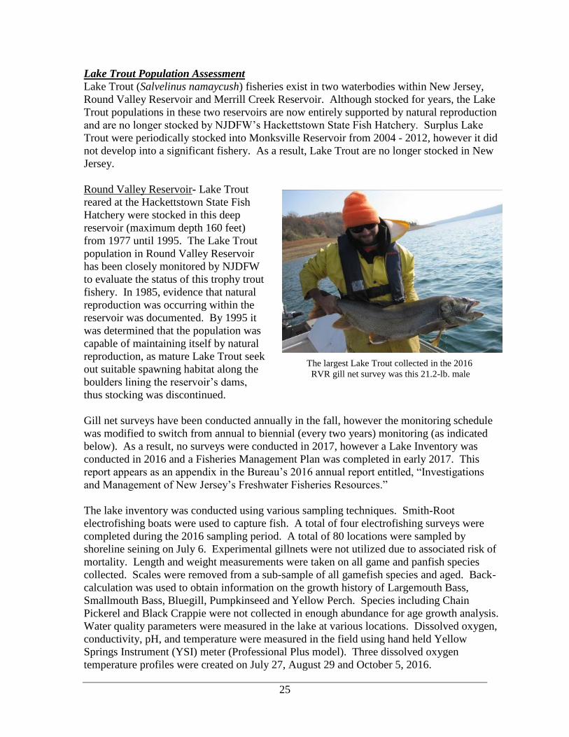
Round Valley Reservoir- Lake Trout
reared at the Hackettstown State Fish
Hatchery were stocked in this deep
reservoir (maximum depth 160 feet)
from 1977 until 1995. The Lake Trout
population in Round Valley Reservoir
has been closely monitored by NJDFW
to evaluate the status of this trophy trout
fishery. In 1985, evidence that natural
reproduction was occurring within the
reservoir was documented. By 1995 it
was determined that the population was
capable of maintaining itself by natural
reproduction, as mature Lake Trout seek
out suitable spawning habitat along the
boulders lining the reservoir’s dams,
thus stocking was discontinued.
Gill net surveys have been conducted annually in the fall, however the monitoring schedule
was modified to switch from annual to biennial (every two years) monitoring (as indicated
below). As a result, no surveys were conducted in 2017, however a Lake Inventory was
conducted in 2016 and a Fisheries Management Plan was completed in early 2017. This
report appears as an appendix in the Bureau’s 2016 annual report entitled, “Investigations
and Management of New Jersey’s Freshwater Fisheries Resources.”
The lake inventory was conducted using various sampling techniques. Smith-Root
electrofishing boats were used to capture fish. A total of four electrofishing surveys were
completed during the 2016 sampling period. A total of 80 locations were sampled by
shoreline seining on July 6. Experimental gillnets were not utilized due to associated risk of
mortality. Length and weight measurements were taken on all game and panfish species
collected. Scales were removed from a sub-sample of all gamefish species and aged. Back-
calculation was used to obtain information on the growth history of Largemouth Bass,
Smallmouth Bass, Bluegill, Pumpkinseed and Yellow Perch. Species including Chain
Pickerel and Black Crappie were not collected in enough abundance for age growth analysis.
Water quality parameters were measured in the lake at various locations. Dissolved oxygen,
conductivity, pH, and temperature were measured in the field using hand held Yellow
Springs Instrument (YSI) meter (Professional Plus model). Three dissolved oxygen
temperature profiles were created on July 27, August 29 and October 5, 2016.
The largest Lake Trout collected in the 2016
RVR gill net survey was this 21.2-lb. male

26
The following recommendations were made Round Valley Reservoir Fisheries Management
Plan:
Management Objectives
1. Continue to manage Round Valley Reservoir’s the two-story fishery.
2. Improve the size structure and growth of Lake Trout and Rainbow Trout.
3. Improve the size structure and growth of both Largemouth and Smallmouth Bass.
4. Improve the forage base for all sportfish and reduce biological demand on all prey
species, including Bluegill.
Recommendations
1. Maintain current Lake Trout regulations to reduce the density of 15 to 24-inch Lake
Trout to increase growth and reduce predation pressure on prey species.
2. Continue to monitor Lake Trout population, on a biennial basis (as opposed to the
existing annual monitoring schedule) and evaluate current regulations and potential
regulation changes.
3. Maintain Trophy Trout regulations for Rainbow and Brown Trout (minimum size of 15
inches / daily limit of 2 combined species).
4. Continue to stock approximately 6,500 trout in 2017, with consideration to adjust
stocking rates in response to changing factors such as food availability, documented trout
growth, lowered pool elevation, etc.
5. Additional sampling should be conducted during the spring to further evaluate the
Largemouth Bass Population. Subsequent sampling should be conducted in three to five
years.
6. Continue to stock Golden Shiners in the short-term, until a determination is made as to
whether it has resulted in the establishment of a reproducing population, otherwise
stocking by NJDFW should be discontinued.
7. Consider potential fish habitat projects to benefit warmwater fish assemblage including,
but not limited to bass, sunfish, and shiners.
(Federal Grant F-48-R, Project I) (Crouse)
Heaviest Largemouth Bass (8.85 lbs.) captured by BFF staff during a 2016 (left)
electrofishing Round Valley Reservoir. (right).

27
Merrill Creek Reservoir- Merrill Creek Reservoir is a 650-acre privately-owned reservoir
located in Harmony Twp., Warren County that is open to public fishing. Following
construction and filling in 1988, a variety of fish species have been stocked in this deep-
water reservoir (200 ft deep) by NJDFW to establish and maintain desirable sport fisheries
for Smallmouth Bass as well as Rainbow, Brown, and Lake Trout. The reservoir’s fishery is
managed by the Merrill Creek Owners Group in cooperation with Fish and Wildlife. This
team meets annually to review and discuss fisheries data collected by the owner and their
consultant, and to make management decisions. In recent years, Lake Trout have been the
primary management focus and the owner’s consultant annually monitors the Lake Trout
population in the fall using gill nets. When the gill net survey data indicated that Lake Trout
were naturally reproducing in the reservoir, stocking of this species was discontinued in
2013.
In 2017, the Bureau of Freshwater Fisheries deployed four experimental gill nets in Merrill
Creek Reservoir overnight, 11/8/17 – 11/9/17, to survey the juvenile Lake Trout population
and supplement fisheries data collected the prior week by the owners’ fisheries consultant. A
total of 41 fish were captured during the survey, representing 9 species: Lake Trout (18),
Smallmouth Bass (10), Rock Bass (3), Alewife (3), Yellow Perch (2), Rainbow Trout (2),
Brown Bullhead (1), Yellow Bullhead (1), and Common Carp (1).
The number of Lake Trout captured during
surveys conducted by the Bureau was
consistent with the three previous years
(same gear and effort); 18 (2016), 20
(2015), and 27 (2014). The Lake Trout
captured in the 2017 survey ranged in size
from 195 – 650 mm (7.7 – 25.5 in.) and the
heaviest fish weighed 2.8 kg (6.2 lbs.).
Four Lake Trout, ranging in size from 520 -
625 mm (20.5 – 24.6 in.) were fin clipped
which indicated they were stocked
(hatchery origin) rather than wild-born in
the reservoir. The remaining 14 lakers
captured were not fin-clipped and are
considered to be the product of natural
reproduction. (Federal Grant F-48-R,
Project I) (Hamilton)
Jane Bullis, Merrill Creek Reservoir staff, holding
an 8 lb. Lake Trout (28.5”) captured in gill nets set
by their consultant at the reservoir in 2017.

28
Landlocked Salmon
Only a handful of deep lakes in New Jersey have suitable year round habitat for coldwater
fish like trout and salmon. Landlocked Salmon (lake dwelling form of Atlantic Salmon
Salmo salar) prefer water temperatures less than 21°C (70°F) and dissolved oxygen levels
greater than 5 mg/L, but can withstand warmer, less oxygenated water conditions for short
periods. Landlocked Salmon, not native to New Jersey, were stocked in several waters over
a half-century ago, and the historical state record for Landlocked Salmon is an 8-pound fish
caught from Lake Aeroflex in 1951.
In 2006, the DFW began stocking Landlocked Salmon into two north Jersey lakes, Lake
Aeroflex and Lake Wawayanda (Sussex), to provide anglers with an opportunity to fish for
this unique coldwater sport fish close to home. The salmon stocked are surplus fish provided
by Massachusetts Division of Fisheries and Wildlife in exchange for surplus Northern Pike
from the Hackettstown State Fish Hatchery.
From 2006-2013, spring yearling salmon
at about 200 mm (8 in.) were stocked
each May in lakes Wawayanda and
Aeroflex immediately upon their arrival
from Massachusetts. In 2013 the
Hackettstown State Fish Hatchery began
retaining a portion of the salmon for 4-
11 months and growing them to a much
larger size (300-500 mm / 12-20 inches)
before stocking. In 2014 Tilcon Lake
(Morris) was added to the salmon
stocking program. Stocking salmon at a
larger size made a big difference in both
angler interest and angling success.
Although no assessment activity for
Landlocked Salmon occurred during
2017, a fishing regulation change was
proposed that would establish harvest
regulations for salmon in 2018 on
Trophy Trout Lakes (Round Valley Reservoir and Merrill Creek Reservoir). The 15-inch
minimum size and daily creel of 2 Landlocked Salmon (in combination with Brown and
Rainbow Trout) would pave the way for Fish and Wildlife to expand the salmon stocking
program into one or both reservoirs. Landlocked Salmon are closely related to Brown Trout
and the stocking of salmon helps fill a void left when Fish and Wildlife discontinued
stocking Brown Trout in 2014 (due to a disease at the Pequest Trout Hatchery). (Hunter and
Angler Fund) (Hamilton)
NJ angler with Landlocked Salmon (25 in. / 4 lbs.)
from Lake Aeroflex.

29
Stocked Trout Movement Study in the Big Flat / Flat Brook Catch and Release Area
The Big Flat / Flat Brook is part of the Division’s Spring and Fall Trout Stocking Programs.
The river receives 34,000 trout each spring, the third highest allocation in a single waterbody
besides the Musconetcong River and the South Branch of the Raritan River. The river is one
of 14 stocked rivers closed to fishing until 5 pm on designated weekly stocking days
following opening day. Although it is considered one of the state’s most popular trout
stocked waters, angler success in the Flat Brook is limited. Each year many anglers call the
NJDFW to complain about the lack of fish found throughout the Flat Brook despite its
generous allocation. Low numbers of trout in the Flat Brook was consistently documented in
the numerous electrofishing surveys conducted by the Bureau over time. For more
information on these surveys, see the Trout Waters with Special Regulations section of this
report (pages 39 and Appendix A pages A2-A4 and A7). In 2014 Catch and Release (C&R)
regulations were implemented on a 4.2-mile section of the Flat Brook, from Rt. 206
downstream to the Roy Bridge, to determine the influence of angler harvest on the low
numbers of available trout and an effort to improve angler success. The Flat Brook is only
one of two waters in the State designated as Catch and Release Only in the state.
To help answer these questions, NJDFW
staff implemented a trout telemetry study
in the Catch and Release area in the spring
of 2017. Radio transmitters were
surgically implanted into 40 Rainbow
Trout from the Pequest Trout Hatchery (2
groups of 20). Half of the fish were
stocked one week after opening day and
the remaining were released about a month
later. Scanning for tagged trout was
performed daily for the first two weeks,
then every other day for the remainder of
the study. In addition, an un-manned station, operated 24 hours a day, 7 days a week, was
deployed near the confluence with the Delaware River to record any tagged fish that were
about to leave the Flat Brook system.
When a transmitter could not be found near the last known location, staff searched the entire
length of the Flat Brook, from Sawmill Pond to the confluence with the Delaware River, by
scanning for the signal. The un-manned station was also checked each day to see if the fish
entered the Delaware River. There were a few locations where the river could not be
accessed by vehicle or by foot, staff used kayaks and floated these remote areas scanning for
lost signals. If there still was no signal, staff would drive around the roads throughout the
Flat Brook watershed scanning for lost signals, focusing on known Great Blue Heron
rookeries.
The study lasted a total of 124 days. All 40 transmitters were either lost or found outside of a
fish by September 11, 2017. This was far shorter than the 230 days of expected battery life.
Seventy-six days were spent recording the location of at least one tagged fish. An average
day lasted 5.5 hours and two staff personnel were assigned on most days. This resulted on
over 800 man-hours spent on this project scanning and locating tagged trout or looking for
Radio transmitter surgically implanted into Rainbow Trout

30
lost transmitters. Sixteen transmitters were never recovered by the end of the study and were
assumed taken away from the stream beyond the distance of the receiving equipment. Other
telemetry studies have shown reliability in the transmitters with a less than 1% failure rate.
Therefore, all lost transmitters were believed to be a result of predation and not transmitter
failure. These fish were most likely eaten by birds and flown away from the stream.
Twenty-four transmitters were found and recovered, some of which were found on land by
the remains of trout, in scat piles, or found in mammal runs or den-like areas. Three
transmitters were tracked to a Great Blue Heron rookery, but not recovered. Five
transmitters were found after some time, at the exact location the trout was stocked. Since it
could not be determined if these tags were "dropped" by the trout or the result of predation,
these five transmitters were not used in any analysis, leaving a sample size of 35 of 40
transmitters. Overall, it was determined that 19 transmitters, including the 16 not recovered,
were lost due to avian predation and 16 transmitters lost to mammalian predation, but other
predation types were possible. Individual tagged trout were confirmed alive 3 days to 122
days after being stocked, with an average of 52 days (see figure below).
Initial movement from each of the three stocking points was recorded. Nineteen trout
initially moved downstream, 10 moved upstream, and 6 did not move from their stocking
location, but were determined to still be alive at least a week after stocking. The number of
days each trout spent at their stocking location before moving ranged from 0 to 56 days, with
an average of 12 days before moving. There was no statistical difference between stocking
locations, with regards to the number of days a fish stayed in its initial location before
moving, number of days a fish remained alive, or the distance or direction a fish traveled.
Furthest distance a tagged trout moved from its stocking location ranged from 0 to 1.85
miles, with an average of 0.28 miles. The total distance an individual trout moved ranged
from 0 to 1.95 miles with an average of 0.45 miles (see figure below).
Dropped radio transmitter found among fish scales
and bones, an obvious sign of mammal predation. Number of days tagged trout survived.

31
The data collected during this study confirmed that the trout are not leaving the Flat Brook
watershed by moving downstream to the Delaware River. The un-manned recording station,
positioned near the Delaware River confluence, did not record a single radio tagged trout. A
second question this study was designed to answer was, “Are the stocked trout leaving the
Catch and Release area, but still remaining in the Flat Brook System?” Ultimately the
answer to this question is no. Thirty-four of the 35 radio tagged trout remained inside the
C&R area. The third question was, “Are the fish remaining in the C&R area, but moving
minor distances into areas that electrofishing equipment cannot sample effectively due to
depth or flow?” Results from the study showed that some of the trout are moving into these
deeper pools and high flow areas. What the study also showed is that not all of the radio
tagged trout moved into these deeper pools. What is certain, is that all 40 radio tagged trout
were lost before the end of the summer. It is fairly certain that 35 of the 40 radio tagged trout
were lost due to some sort of predation, while the other 5 may have been lost due to
predation or simply just dropped by the fish, possibly due to suture failures. This study
showed that predation is definitely a key factor in limiting trout availability within the Flat
Brook C&R area.
The stocked trout movement study answered many key questions on why the Flat Brook
C&R area is not holding trout to expected levels, but it also more questions about movement
and predation rates on stocked trout in the Flat Brook system. In an attempt to further
understand what is happening to stocked trout in the Flat Brook system, the Division of Fish
and Wildlife is partnering with the Montclair State University and its School of Conservation
to continue and expand this study for a second year. A graduate student will follow and
expand the design of this stocked trout movement study to gain further knowledge of stocked
trout movements and predation rates in the Flat Brook system. The information garnered
from the continuation of this study will be used to guide future management decisions about
stocking rates on the Flat Brook and whether the C&R regulation is appropriate for this area.
(Federal Grant F-48-R, Project I) (Shramko)

32
Stream Temperature Monitoring
In 2013 the Bureau established an ambient stream temperature monitoring network on
streams having trout fisheries that are recreationally important or of conservation interest.
The temperature data is used to assess current temperature conditions, evaluate long term
trends, determine if ambient water quality is consistent with NJDEP’s Surface Water Quality
Standards, and aid in the management of coldwater (trout) fisheries in these streams. In 2017
water temperature was monitored at 39 sites. Twenty-five of the sites were located on 17
recreationally important, major trout-stocked streams. (Federal Grant F-48-R, Project I)
(Collenburg)
Trout Stocked Waters Stream Temperature Assessment
Identifying the thermal classification of a stream is a useful tool in giving a basic
understanding of the thermal regime of a stream. The figure below shows the proportion of
all summer (June 1 to August 31) stream temperature records above 25°C (Critical
Threshold), between 22-25°C (Tolerable), between 18-22°C (Sub-Optimal), and below 18°C
(Cold). The categories are based on trout preferences or limitations to certain stream
temperatures. The “Cold” category is based on research that shows optimum temperature for
overall welfare, activity, and feeding is below 18°C, 18-22°C is a range that is sub-optimal
and temperature begins to effect feeding and growth, 22-25°C is a range that is tolerable
(maybe only for short durations), and temperatures reaching over 25°C can kill trout exposed
to it after only a couple hours.
Sites on the Flat Brook/Big Flat Brook, the Claremont section of the South Branch of the
Raritan River, Manasquan River, and Pequest River had the highest percentages of cold
temperatures (below 18°C) throughout summer, while the sites on the Wanaque River and
North Branch of the Raritan River had the highest percentage of readings exceeding 25°C
(see figure below)
Proportion of 2017 summer stream temperatures that fit into each thermal regime category: cold,
cool, and sub-optimal, and critical threshold.
0
20
40
60
80
100
FLA
TBK
20
6
MA
N1
PEQ
UES
T
RA
RSB
RK
LG
BLK
RIV
HSP
RA
RSB
RSO
L
MET
NB
R
PA
ULV
IA
RA
M1
RA
RN
BR
WA
N1
Per
cen
t o
f re
adin
gs
Site ID
Critical Threshold (>25)
Tolerable (22-25)
Sub-Optimal (18-22 C)
Cold (<18 C)

33
Summer temperatures are critical for trout survival and a continued warming trend may
threaten the future of the NJDFW’s trout stocking program and shorten the length of time
trout can survive in any section. The summer of 2017 was comparatively cooler than the
previous two years, which should have improved the trout holdover capacity in more
marginal locations (see figure below).
Average summer (June 1 - August 31) air temperature in Northern New Jersey from 1980 to 2017.
Distribution of trout is strongly linked to optimal temperature thresholds for trout and by
knowing the timing and for how long these thresholds are exceeded can help NJDFW make
management decisions based on when and where trout should be stocked. This year on our
major trout stocked streams, the rolling seven-day average of the daily maximum stream
temperature was analyzed at each site from the opening day of trout season, through the first
7 weeks of trout season (in-season stocking period), to the eventual exceedance of each sites
thermal threshold for trout (see figure below). The thermal threshold was defined as 21℃,
as above this temperature trout become stressed, have other negative physiological effects,
and may potentially die after chronic exposure.
The rolling seven-day average of the daily maximum stream temperature on important NJ trout
stocked waters during the trout stocking period.
None of the streams exceeded the thermal threshold during the seven weeks of trout stocking
(April 8th – May 26th), but the summer holdover capacity of many streams is limited as most
646566676869707172737475
19
80
19
82
19
84
19
86
19
88
19
90
19
92
19
94
19
96
19
98
20
00
20
02
20
04
20
06
20
08
20
10
20
12
20
14
20
16
Tem
per
atu
re (
Fah
ren
hei
t)Northern NJ Average Summer Temp (June-Aug) 1980 - 2017
0
5
10
15
20
25
4/8/2017 5/8/2017 6/8/2017 7/8/2017
Axi
s Ti
tle
Rolling 7-day average of the daily maximum stream temperature during weeks 1-7 of trout stocking
FLATBROOK206MANASQUAN1TOMS1
BLACKHSB
METNBR1
METSBR1
PEQUAN1

34
streams exceeded 21℃ by mid-June. This is not always the case (yearly variation) and
microhabitats exist within large systems providing areas of thermal refuge, but this is
certainly a limitation to the density of trout in some of these streams. As temperatures
continue to rise, adjustments can be made to stocking practices to help recreational anglers
gain as much access to the popular sportfish. Some streams may warm more than others
based upon their buffering capacities (defined often by geology, riparian zone, water usage,
and other human impacts), and these streams should continue to be monitored to make those
determinations. (Federal Grant F-48-R, Project I) (Collenburg)
Trout Production Stream Temperature Study
2015 marked the beginning of a study to collect year-round continuous stream temperature
data on Trout Production streams and assess their naturally reproducing trout populations.
Excessively cold fall and winter temperatures (approaching 0°C) can limit wild trout
recruitment via late emergence and slow growth. Fourteen Trout Production streams were
selected, based on location (i.e. watershed, proximity to our office) and on population
structure (struggling or well-established trout populations) to investigate. Year-round stream
temperature monitoring and electrofishing surveys were conducted over a three-year period.
The goals of the study are multi-faceted: (1) to develop a year to year analysis of how stream
temperature is influencing New Jersey’s wild trout populations, (2) submit data to the
Department to determine if any streams qualify for impairment designation as part of 303(d)
listing, and (3) to develop metrics based on GDD, an understanding of emergence times,
critical summer time temperatures, fall/winter/spring temperatures, and/or aerobic scope
curves to identify which streams are the best candidates for possible translocations of wild
trout.
In the spring of 2015, fourteen Trout Production streams were selected and stream
temperature monitoring devices were placed. The streams included: Beerskill Creek, Black
Brook, Forked Brook, Hickory Run, Raritan River S/Br. (Trib.)(Drakestown), Raritan River
S/Br. (Trib.)(SW of Budd Lake), Rinehart Brook, Rocky Run, Stephensburg Brook, Stony
Brook (Morris-Washington), Sun Valley Brook, Turkey Brook, Trout Brook (Hacklebarney),
and Willhoughby Brook. Subsequently, backpack stream electrofishing surveys, following
EPA bioassessment protocols were conducted during the summers of 2015-2017 to
determine abundance and sizes of wild trout present.
Stream temperature background data (established in 2013) were compared to fisheries survey
data resulted in the following observations:
‐ Streams experiencing the coldest temperatures during trout egg incubation have low wild
trout recruitment. Note: Emergence times are delayed by cold winter stream temperatures,
which may have led to low survival of wild trout (less time/slow growth, more subjected to
redd scour from spring flows)
‐ Trout Production streams with higher Growing Degree Days (GDD) had better recruitment
(streams with slightly warmer winter temperatures).
These observations identify the limiting factors of recruitment of trout in New Jersey and
indicate metrics could be developed for use in the monitoring of stream temperatures and in
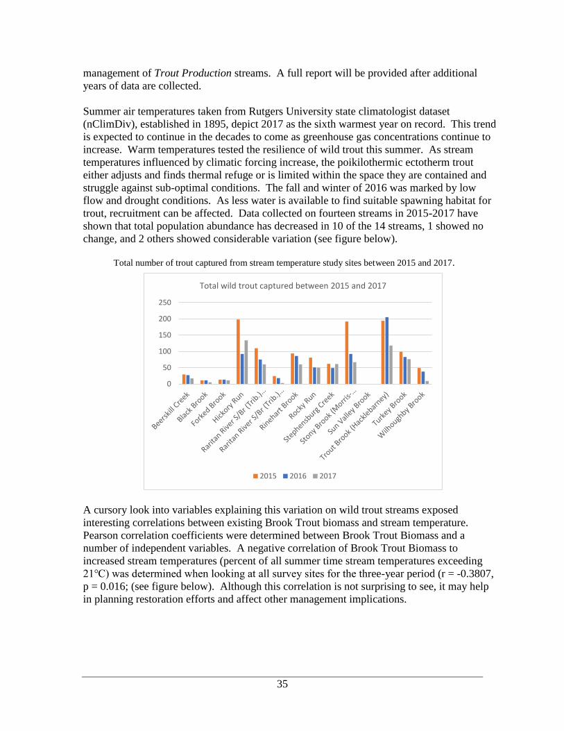
35
management of Trout Production streams. A full report will be provided after additional
years of data are collected.
Summer air temperatures taken from Rutgers University state climatologist dataset
(nClimDiv), established in 1895, depict 2017 as the sixth warmest year on record. This trend
is expected to continue in the decades to come as greenhouse gas concentrations continue to
increase. Warm temperatures tested the resilience of wild trout this summer. As stream
temperatures influenced by climatic forcing increase, the poikilothermic ectotherm trout
either adjusts and finds thermal refuge or is limited within the space they are contained and
struggle against sub-optimal conditions. The fall and winter of 2016 was marked by low
flow and drought conditions. As less water is available to find suitable spawning habitat for
trout, recruitment can be affected. Data collected on fourteen streams in 2015-2017 have
shown that total population abundance has decreased in 10 of the 14 streams, 1 showed no
change, and 2 others showed considerable variation (see figure below).
Total number of trout captured from stream temperature study sites between 2015 and 2017.
A cursory look into variables explaining this variation on wild trout streams exposed
interesting correlations between existing Brook Trout biomass and stream temperature.
Pearson correlation coefficients were determined between Brook Trout Biomass and a
number of independent variables. A negative correlation of Brook Trout Biomass to
increased stream temperatures (percent of all summer time stream temperatures exceeding
21℃) was determined when looking at all survey sites for the three-year period (r = -0.3807,
p = 0.016; (see figure below). Although this correlation is not surprising to see, it may help
in planning restoration efforts and affect other management implications.
0
50
100
150
200
250
Total wild trout captured between 2015 and 2017
2015 2016 2017

36
Scatterplot of total Brook Trout Biomass and percent of all summer time stream temperatures
exceeding 21℃. A significant (p=0.016), negative correlation (r=-0.3807) between the two
variables was found.
Pearson correlation coefficients were determined between Brook Trout Biomass on streams
containing only Brook Trout and mean winter stream temperature. A significant (p=0.012),
positive correlation (r=0.6468) was determined between these variables (see figure below).
Warmer temperatures in the winter are critical for development of eggs and the life cycle of
trout to ensure proper development and emergence times. As stream temperatures decline in
the winter time, so does the activity and metabolism of trout. These are harsh conditions and
influence the growth and survivability of wild trout populations. These data support the
necessity to collect year-round stream temperature data to properly guide management Brook
Trout sampling and management activities. (Federal Grant F-48-R, Project I) (Collenburg)
Scatterplot of total Brook Trout Biomass on streams containing only Brook Trout and mean winter
stream temperature. A significant (p=0.012), positive correlation (r=0.6468) between the two
variables was found.
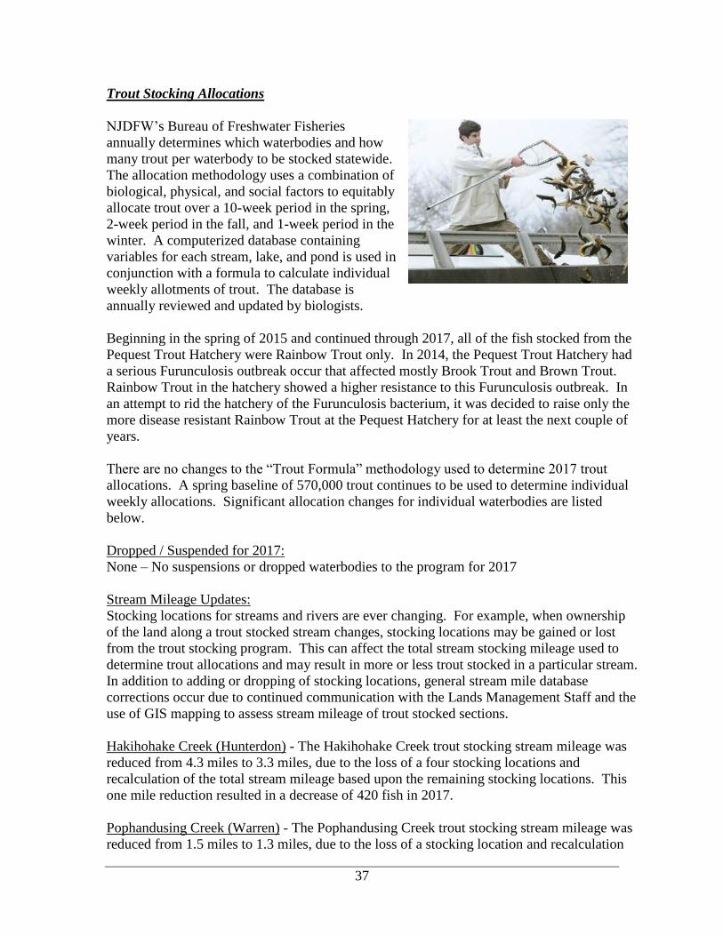
37
Trout Stocking Allocations
NJDFW’s Bureau of Freshwater Fisheries
annually determines which waterbodies and how
many trout per waterbody to be stocked statewide.
The allocation methodology uses a combination of
biological, physical, and social factors to equitably
allocate trout over a 10-week period in the spring,
2-week period in the fall, and 1-week period in the
winter. A computerized database containing
variables for each stream, lake, and pond is used in
conjunction with a formula to calculate individual
weekly allotments of trout. The database is
annually reviewed and updated by biologists.
Beginning in the spring of 2015 and continued through 2017, all of the fish stocked from the
Pequest Trout Hatchery were Rainbow Trout only. In 2014, the Pequest Trout Hatchery had
a serious Furunculosis outbreak occur that affected mostly Brook Trout and Brown Trout.
Rainbow Trout in the hatchery showed a higher resistance to this Furunculosis outbreak. In
an attempt to rid the hatchery of the Furunculosis bacterium, it was decided to raise only the
more disease resistant Rainbow Trout at the Pequest Hatchery for at least the next couple of
years.
There are no changes to the “Trout Formula” methodology used to determine 2017 trout
allocations. A spring baseline of 570,000 trout continues to be used to determine individual
weekly allocations. Significant allocation changes for individual waterbodies are listed
below.
Dropped / Suspended for 2017:
None – No suspensions or dropped waterbodies to the program for 2017
Stream Mileage Updates:
Stocking locations for streams and rivers are ever changing. For example, when ownership
of the land along a trout stocked stream changes, stocking locations may be gained or lost
from the trout stocking program. This can affect the total stream stocking mileage used to
determine trout allocations and may result in more or less trout stocked in a particular stream.
In addition to adding or dropping of stocking locations, general stream mile database
corrections occur due to continued communication with the Lands Management Staff and the
use of GIS mapping to assess stream mileage of trout stocked sections.
Hakihohake Creek (Hunterdon) - The Hakihohake Creek trout stocking stream mileage was
reduced from 4.3 miles to 3.3 miles, due to the loss of a four stocking locations and
recalculation of the total stream mileage based upon the remaining stocking locations. This
one mile reduction resulted in a decrease of 420 fish in 2017.
Pophandusing Creek (Warren) - The Pophandusing Creek trout stocking stream mileage was
reduced from 1.5 miles to 1.3 miles, due to the loss of a stocking location and recalculation

38
of the total stream mileage based upon the remaining stocking locations. This 0.2 mile
reduction resulted in a decrease of 90 fish in 2017.
Paulins Kill (Warren and Sussex) - The Paulins Kill stocking run was updated for 2017.
Over the years, the Pequest Hatchery has been producing slightly larger fish than when the
Paulins Kill run was designed. In some cases, stocking loads were beginning to get
overcrowded due to this increase in fish size. On the Paulins Kill, stocking crews were
worried that they would lose fish due to the overcrowding if they were to have any sort of
problem or delay and a re-design of the run was necessary. This re-design found that the
Paulins Kill culminated in a reduction of stream mileage on the river. No stocking points
were lost, but through the use of new and more accurate technology (GIS mapping) it was
determined that the Paulins Kill stream mileage is actually less than what the allocation
program was using. This correction in stream mileage resulted in a 5% or 1,750 fish
reduction in 2017. The Paulins Kill received about 30,500 total fish in 2017.
Other Trout Allocation Changes:
Culver’s Creek (Sussex) - The trout allocation formula uses multiple waterbody attributes to
determine the trout allocation and stocking schedule. One factor it uses for streams is known
as the “recreational use potential” or RUP. The RUP is made up of 3 smaller categories;
angler interest, parking availability, and amount of public land on the stream. The RUP for
Culver’s Creek was decreased from a value of 3 to a value of 2 after it was determined,
through conversations with the stocking crews and the conservation officer assigned to that
area, that angler interest on this stream should be switched from moderate to low. This
change affects the number of times this stream is stocked throughout the spring season and
also the total number of trout it receives as determined by the RUP value. This change
resulted in 450 less trout stocked for the spring season and from 5 in-season stockings to 2
in-season stockings. The pre-season stocking was not affected.
A summary of trout stocked from NJDFW’s Pequest Trout Hatchery during 2017, by season
and species, is found in the table below. (Hunter and Angler Fund) (Shramko)
Spring 2017 Trout Stocking Summary
Species Type Avg. Length Lbs. # Fish
Rainbow Trout Production 11.2" 287,627 581,550
Broodstock 15.7" & 21.5” 18,531 7,380
Totals 306,158 588,930
Fall 2017 Trout Stocking Summary
Species Type Avg. Length Lbs. # Fish
Rainbow Trout Production 14.6" 28,168 20,540
Broodstock 19.8" 2,965 770
Totals 31,133 21,310
Winter 2017 Trout Stocked Lakes Program Summary
Species Type Avg. Length Lbs. # Fish
Rainbow Trout Production 14.6” 7,192 5,040
Totals 7,192 5,040

39
Trout Waters with Special Regulations
Catch & Release Trout Regulation Assessment
Catch & Release fishing regulations were
implemented in 2014 on sections of two trout-
stocked streams – the Flat Brook/ Big Flat Brook
and the Ken Lockwood Gorge on the S/Br. Raritan
River. Both support reproducing trout
populations. Electrofishing surveys are routinely
conducted on these streams to provide data for
evaluating the effect of the regulation change on
these trout fisheries.
South Branch of the Raritan River- Recognized
for its great scenery and fish habitat, the 2.5-mile
section of the South Branch of the Raritan River
known as the Ken Lockwood Gorge is very
popular among anglers looking for Catch and
Release (C&R) (and artificial lures only)
opportunities. Wild Brown Trout are the
foundation of the fishery in this section of river,
with numbers that seem to greatly fluctuate.
Brook Trout (soon to be listed state Special
Concern) are rarely encountered, with never more than a few individuals. This section is
stocked by NJDFW in both the spring and fall, and periodically stocked privately. Prior to
2014, this section was regulated as a Year-Round Trout Conservation Area (TCA) (1 trout
per day greater than 15 inches). The Catch and Release regulations went into effect in 2014.
The popularity of the Ken Lockwood Gorge has warranted NJDFW to monitor the fish
assemblage in this area very closely over the years, with electrofishing surveys conducted at
2 established locations during the summers of 2006, 2007, 2013, 2015, and 2016. No
surveys were conducted in the Ken Lockwood Gorge in 2017. (Federal Grant F-48-R, Project
I) (Crouse)
Flat Brook/Big Flat Brook- Four sites per year on the Flat Brook/Big Flat Brook Catch and
Release (C&R) section were electrofished annually since 2012 (see Appendix A pages A2-
A4 and A7). For the purpose of this report, this section will be referred to as the Flat Brook
C&R area. Although this stream reach is trout-stocked in the spring and fall and naturally
reproducing trout occurs within this section, few trout were encountered during these surveys
(see table below). The “Three Bridges” site yielded significantly more trout in 2015, 2016,
and 2017 (counting the observed trout in 2016 - see footnote in table). After five years of
study, it is clear that stocked trout are not holding throughout the C&R area in good numbers.
Some trout appear to be utilizing deep, non-wadeable, very difficult to survey, pools in this
stream, as evidenced by the 2014 informal (non-standardized) electrofishing survey that was
conducted in a large, deep pool (see footnote in table), while other trout may be migrating out
of the C&R area outright, or are subject to high predation rates.
Ken Lockwood Gorge

40
Electrofishing locations along the Big Flat Brook and Flat Brook from 2012 – 2017.
Year Water Temp
Total Brook Trout Brown Trout Rainbow Trout
Trout Wild Stocked Wild Stocked Wild Stocked
Big Flat (between Rt. 206 & Rt. 560 bridges)
2012 19.9°C
(67.8°F)
3 2 1
2013 17.1°C
(62.8°F)
8 2 1 5
2014 17.6°C
(63.7°F)
3 3
Big Flat (Old Police Barracks) (page A2)
2015 18.6°C
(65.5°F)
6 3 3
2016 19.3°C
(66.7°F)
3 2 1**
2017 18.2°C
(64.8°F)
5 5
Big Flat (Station 2 – upstream from Blewitt Tract)
2012 20.8°C
(69.4°F)
3 3
2013 18.6°C
(65.5°F)
7 5 1 1
2014 17.6°C
(63.7°F)
8 5 3
Big Flat (between Rt. 560 & “Warner’s Hole”) (page A3)
2015 17.1°C
(62.8°F)
10 10
2016 20.4°C
(68.7°F)
8 8
2017 18.2°C
(64.8°F)
19 19
Big Flat (Station 1 – upstream from Blewitt Tract) (page A4)
2012 19.1°C
(66.3°F)
8 7 1
2013 0
2014 17.5°C
(63.5°F)
2 2
2015 19.3°C
(66.7°F)
3 1 2
2016 19.5°C
(67.1°F)
2 1 1
2017 16.9°C
(62.4°F)
0
Flat Brook (above Roy Bridge - just downstream of rifle range pool)*
2012 18.8°C
(65.8°F)
6 1 1 2 2
2013 16.3°C
(61.3°F)
4 1 1 2
2014 17.3°C
(63.1°F)
2 1 1
Flat Brook (Three Bridges WMA) (page A7)
2015 18.7°C
(65.7°F)
48 1 47
2016 18.6°C
(65.5°F)
8 1 7***
2017 16.6°C
(61.9°F)
44 2 42***
* In addition to this site, the “rifle range pool” was electrofished. Due to the large size of the pool (wide, long, and
deep) not all the trout were captured, however, a total of 15 trout (14 Rainbow Trout and 1 Brook Trout) were
netted. They ranged in size from 11.3 – 15.7 inches and all appeared to be of hatchery origin (stocked). The
brook has many pools similar to this one that hold trout but are difficult to effectively sample.
** 8-10 stocked rainbow trout were seen but located in a pool too deep to effectively sample and escaped capture.
*** 35 to 50 stocked rainbow trout were seen, but not captured due to a deep hole that in 2016 & 2017 could not be
sampled. This deeper location was able to be sampled in 2015 and accounts for the difference in trout captured
from 2015 with 2016. In 2017 an additional 35-50 stocked rainbow trout were seen for a total of 77 to 92 total
stocked Rainbow Trout.

41
To help biologists understand if and when trout may be migrating out of the areas conducive
to sampling, six additional surveys were conducted in 2016 and one in 2017. These seven
additional surveys were very different than the typical standardized 150-m surveys conducted
previously. To sample a larger area, these surveys covered a total of 1,200 nearly contiguous
meters, with only a few pools throughout the 1,200 m that were too deep to sample with
backpack electrofishing units. In these deeper pools, visual observations of the trout were
counted. Only stocked trout were collected and counted, while wild trout and other species
were observed and noted only if they were rare or never encountered in the Flat Brook
system. The 1,200-m survey section encompassed 3 of the 150-m standardize surveys
previously sampled. These 150-m surveys conducted in July / August each year from 2012
through 2015 were very consistent and found on average 11 stocked trout per 100 m. The
consistency of this data suggests that 11 trout/100 m is an average summertime density for
these locations (see table below).
The Catch and Release regulation area on the Big Flat Brook / Flat Brook receives a
preseason stocking and seven successive weekly stockings during the spring trout program.
The 1,200 m survey section of the C&R regulation area receives about 2,500 trout per season
(approximately 312 trout/week). The 1,200 m survey conducted in 2017 occurred on
6/15/17, 20 days after the last spring stocking. The following table shows a breakdown of
the data collected of the six 1,200 m surveys from 2016, the one 1,200 m survey from 2017,
and other relevant survey data collected in the area. Additional information is compiled in
Appendix A (pages A2-A4 and A7). The large increase in trout/100 m found during the
2017 survey is likely due to improved stream conditions in 2017 over 2016. Spring time
stream flows in 2017 were above average and remained that way into the early summer
months. The higher than average stream flows aid in water temperatures staying cooler
longer and gives trout more and deeper water to evade capture from predators. If all of the
trout remained in this study area, the area would be holding about 208 trout/100 m at the time
of this survey. The survey conducted in 2017 on this section found 36 trout/100 m, far less
than the possible 208 trout/100 m. A single pass backpack electrofishing survey is not
anticipated to capture all of the fish in an area, nor are all stocked trout expected to remain in
the C&R section since stocking began in the middle of March, but the 36 trout/100 m survey
results are far lower than what should be expected. In fact, the 36 trout /100 m are closer to
what you should expect to find if the area was stocked 1.5 times (312 trout per stocking)
instead of 8 times. It is possible that the trout still remain within the Catch and Release area
in deep pools outside of the 1,200-m study area, but it is also a possibility that the trout are
swimming even greater distances and leaving the C&R area outright leaving the Flat Brook
system entirely. It is also possible that these trout are not migrating out from where they
were stocked, but being lost to bird or mammal predation. Finally, it is also possible (but less
likely) that the backpack electrofishing equipment is less efficient in the Big Flat Brook
system, due to low conductivity and deep pools.
To answer these questions, Division staff implemented stocked trout movement study in the
Catch and Release area on the Flat Brook in the spring of 2017. A summary of this study
can be found in the section titled, Stocked Trout Movement Study in the Flat Brook C&R
Area: Preliminary Findings (page 29) and in Appendix G. (Federal Grant F-48-R, Project I)
(Shramko)

42
Big Flat Brook Catch & Release Regulation Area Surveys 2012 – 2017.
Survey loc 1
(fish/100m)
End of loc 1
to Rt 560
(fish/100m)
Rt 560 to
beginning
survey loc 2
(fish/100m)
Survey loc 2
(fish/100m)
Old Police
Barracks loc
(fish/100m)
Total area
(fish/100m)
7/30/12
45 days after last stocking ----- ----- ----- 9 ----- -----
8/29/13
45 days after last stocking ----- ----- ----- 11 ----- -----
7/30/14
45 days after last stocking ----- ----- ----- 9 ----- -----
7/14/15
45 days after last stocking 13 ----- ----- ----- 12 -----
5/16/16
3 days after stocking 14 8 15 10 13 13
5/23/16
3 days after stocking 32 10 21 23 24 21
5/31/16
3 days after stocking 15 2 12 5 39 13
6/22/16
25 days after last stocking 7 1 12 9 21 10
7/19/16
52 days after last stocking 5 ----- ----- ----- ----- -----
8/2/16
66 days after last stocking ----- ----- ----- ----- 7 -----
8/18/16
82 days after last stocking 5 1 9 5 10 6
10/4/16
129 days after last stocking 1 0 1 0 5 1
6/15/17
20 days after last stocking 45 20 41 22 23 36

43
Seasonal Trout Conservation Area Assessment
Pequannock River - The trout stocked section of the Pequannock River is a popular location
to fish and is known to hold populations of wild Brown Trout. Much work has been done to
improve water temperatures downstream of the reservoirs on the Pequannock River and a
resurgence of the wild trout populations have been documented. The current extent includes
the upper most boundary of the Route 23 (Paterson-Hamburg Turnpike) bridge in Kinnelon
downstream to the Paterson-Hamburg Turnpike bridge in Pompton Lakes. This section
includes the seasonal Trout Conservation Area downstream from Appelt Park. It was
suggested by several anglers to regulate this section of the Pequannock River, or part of it,
under the new Wild Trout Stream regulations to provide more protection to the wild Brown
Trout population that is known to occupy this section. Currently, there is a Wild Brown
Trout Enhancement section above Charlottesburg Reservoir.
Four surveys were conducted in the trout stocked section to assess the wild population of
Brown Trout (see Appendix A pages A23-A26). A total of 53 wild Brown Trout, including
12 young-of-the-year (YOY) and 24 stocked Rainbow Trout, were captured during the four
surveys. The abundance of wild Brown Trout is low but there is heavy fishing pressure in
this section especially at Appelt Park where the lowest number of trout were captured from
all surveys (also the most heavily fished section). An angler creel survey was conducted in
this section on the opening day of trout season in 2017 and found that anglers were
harvesting wild Brown Trout, as well as stocked Rainbow Trout. Some anglers commented
that they practiced catch and release for the wild Brown Trout, but other anglers were
indiscriminate and would keep a wild Brown Trout as readily as a stocked Rainbow Trout.
More angler and electrofishing surveys may be necessary to collect enough data to determine
if a change is warranted. (Federal Grant F-48-R, Project I) (Collenburg)

44
Wild Trout Stream Regulation Assessment and Development
NJDFW has documented reproducing trout populations in nearly 200 streams (or stream
segments) statewide. Most of these streams are tributaries to larger, trout-stocked streams in
northern New Jersey. The primary means of regulating fishing for wild Brook, Brown, and
Rainbow Trout has been through the Wild Trout Stream (WTS) regulation, which is more
stringent (restrictions on fishing gear and harvest) compared to the statewide general
regulation for trout. Designated WTS’s are not stocked with hatchery trout, but rather rely
upon naturally reproducing wild trout populations to provide a recreational trout fishery.
This regulation, and the number of designated streams (29 initially, 36 in 2017), have
changed little since it was adopted in 1990.
In 2014 the Bureau initiated a multi-year project to assess the Wild Trout Stream regulation
and determine if the recreational fishing opportunities afforded by this regulation were
appropriate and adequately addressed the conservation needs of wild trout. Ninety-four
electrofishing surveys were conducted on 57 streams in 2014 and 2015 to obtain current fish
population data. In addition, an online survey for anglers who fish for wild trout in New
Jersey was conducted and scientific literature pertaining to hooking mortality was reviewed.
This information was compiled, analyzed, and used to develop a suite of fishing regulations
that not only highlight the variety of recreational fishing opportunities for wild trout (in
streams), but also protect them. Recommended changes were submitted to the Fish and
Game Council for their review in February 2017 and unveiled at the annual public trout
meeting held later that month. Staff also attended meetings of ten Trout Unlimited chapters
during the spring to present the potential changes and further solicit angler feedback.
Following a formal sixty-day public comment period, the proposed amendments were
approved by the Fish and Game Council and became effective February 10, 2018.
The centerpiece of these new wild trout fishing regulations is the conservation of wild Brook
Trout, the only trout species native to New Jersey. The number of wild Brook Trout
populations has significantly declined in our state due to
impacts from urbanization, the building of dams and
roadways, and the stocking of non-native trout species.
Due to growing concern over the plight of Brook Trout, a
Brook Trout Conservation Zone has been established for
northwestern New Jersey, where wild Brook Trout are
most abundant. Any Brook Trout caught within this zone
must be immediately released unharmed. NJDFW no
longer stocks Brook Trout (and is currently not stocking
Brown Trout). The private stocking of Brook Trout in the
Zone will no longer be permitted, because this species can
no longer be harvested legally and it prevents interbreeding
with wild Brook Trout. Preventing interbreeding helps
preserve wild Brook Trout gene pools, preserving their
genetic diversity and potential to evolve in response to
environmental change.

45
The Wild Trout Stream regulation has been given a facelift. Three designations (described
below) will highlight the variety of wild trout fishing opportunities available and better align
individual streams with management strategies specific to the wild trout species present.
Many streams previously designated as a Wild Trout Stream were retained, but some were
dropped and others added. All three designations continue to allow anglers to use fly and
spin fishing gear, artificial flies and lures only (no bait or bait scent), and harvest season that
commences in April (coinciding with the Opening Day of the trout season) and continues
through September 15. A new requirement limits anglers to using artificials having a
maximum of three hook points, all of which must be barbless. Previously nine, barbed hook
points were allowed.
• Native Brook Trout Streams – 11 streams almost exclusively inhabited by native Brook
Trout or anticipated to be so as part of Fish and Wildlife’s Brook Trout Restoration
efforts, were singled out for this special regulation. Intended to protect and preserve
wild Brook Trout populations, anglers are encouraged to harvest, if present, Brown and
Rainbow Trout (two per day, species combined, no minimum size) to prevent these non-
native species from gaining a foothold (or the upper hand) and displacing Brook Trout.
All Brook Trout caught must be immediately released unharmed.
• Wild Trout Streams – 17 streams having abundant wild Brown Trout and/or Rainbow
Trout, that also have (or are connected to streams having) wild Brook Trout have been
selected for this designation. The harvest regulations mimic the original WTS regulation
– a two-trout daily limit (species combined) and 9-inch minimum size, except Brook
Trout may not be harvested from streams located within the Brook Trout Conservation
Zone.
• Wild Brown Trout Enhancement Streams – 13 streams with an abundance of wild
Brown Trout provide excellent angling opportunities for this species, which can reach
impressive sizes in some of these streams. The absence of wild Brook Trout in these
streams (or nearby) eliminates the concern of species competition. A higher minimum
harvestable size (12-inch) applies to Brown Trout and 9 inches for Rainbow Trout, if
present, and catch and release on Brook Trout for streams located within the Brook
Trout Conservation Zone.
In addition to the sweeping regulatory changes described above, a new regulation was
implemented in 2018 on streams having abundant wild Brown Trout that Fish and Wildlife
also stocks with Rainbow Trout. The Trout Stocked Waters – Wild Brown Trout Managed
regulation is intended to enhance the existing wild Brown Trout fishery in five streams while
minimizing impacts to those anglers who primarily fish these waters for stocked trout.
Unlike the regulation pertaining to designated Wild Trout Streams, anglers fishing these
waters will continue to be allowed to use bait and up to nine hook points. However, because
wild Brown Trout may reach impressive size in these five streams, a 12-inch minimum size
applies for this species (compared to 9-inch limit for Brook and Rainbow Trout) and the
daily creel of trout may include no more than two Brown Trout. The conservation measure
for Brook Trout (Catch and Release) applies to those streams within the Brook Trout
Conservation Zone.

46
Changes to the Wild Trout Stream regulation
and the creation of the Brook Trout
Conservation Zone are fully explained in an
article, “Giving Wild Trout a Helping Hand,”
that appears in the 2018 New Jersey
Freshwater Fishing Digest (see to right). This
NJDFW publication, readily available online
and wherever NJ fishing and hunting licenses
are sold, contains not only freshwater fishing
seasons, dates and limits, but informative
articles and other details that anglers heavily
rely upon. (Federal Grant F-48-R, Project I)
(Collenburg, Hamilton, and Shramko)

47
Wild Brook Trout Assessment
Anthropogenic landscape changes and past management practices have negatively impacted
New Jersey’s freshwater resources, particularly Brook Trout, the state’s only native trout
species. Of the three species of trout that reproduce in New Jersey streams, Brook Trout are
the least tolerant of habitat degradation. Habitat alteration and stream fragmentation,
diminished water quality, and competition with non-native trout (Brown and Rainbow Trout)
have contributed to the decline of wild Brook Trout in New Jersey. Wild populations of
Brook Trout now persist in less than half their original range in New Jersey and this species
may soon be designated state Special Concern.
NJDFW actively participates in the Eastern Brook Trout Joint Venture (EBTJV), a unique
partnership initiated in 2004 under the National Fish Habitat Initiative (www.fishhabitat.org).
EBTJV is a geographically focused, locally driven, and scientifically based effort to protect,
restore, and enhance aquatic habitat throughout the range of the eastern Brook Trout. The
Venture has produced a range-wide population assessment of wild Brook Trout, completed
extensive work that identifies key threats to wild Brook Trout and their habitats, and
developed conservation strategies to protect, enhance and restore wild Brook Trout. EBTJV
refined the subwatershed status map to a fine-scale catchment level and NJDFW now
conducts surveys to assess the status of Brook Trout in catchments that lack survey data.
This data, as well as data from stream surveys conducted as part of other activities, is entered
into FishTrack (NJDFW’s computerized freshwater fisheries database) and shared with the
EBTJV. (Federal F-48-R, Project I) (Hamilton)
In 2017 a total of 114 surveys were conducted on 54 streams, under a variety of jobs and/or
funding sources, which provided data to document the presence of wild trout species. The
results from all 114 surveys are summarized below and in the table that follows.
• 36 of 54 streams surveyed had wild Brook and/or Brown Trout (no wild Rainbow Trout).
• 16 streams had only wild Brook Trout.
• 11 streams had only wild Brown Trout.
• 9 streams had both wild Brook and Brown Trout
(Tiger Trout, a hybrid of Brook and Brown
Trout, were also present in 2 of these streams).
• 7 surveys conducted at locations where previous
surveys documented wild Brook Trout, did not
yield wild Brook Trout – Black Brook, Cresskill Brook, Drakes Brook (trib.)(Mt. Olive),
Lamington (Black) River (trib.)(Ironia), Mine Brook (trib.)(S. of Mine Mtn), Raritan
River S/Br (trib.)(S. of Hoffmans), and Sun Valley Brook. Further sampling was
recommended to determine if Brook Trout have been extirpated from these streams.
• The Raritan River S/Br was surveyed upstream of the YMCA dam in Mount Olive Twp.
to determine if reproducing Brown Trout have established. Previously exclusive to wild
Brook Trout, staff found limited numbers of wild Brown Trout (no YOY) following the
notching of the dam in 2008. The Brown Trout traversed the notch under high flow
conditions. The dam was later rebuilt to its original height; therefore, the notch was no
longer present. Fortunate for wild Brook Trout in this watershed, no Brown Trout were
found during a 2015 survey or during the recent survey in 2017. Twenty-eight wild
Brook Trout were found (Appendix page A50).

48
Of the 114 surveys, 14 were specifically conducted to investigate Brook Trout status in
relation to (1) extirpation concerns based upon recent survey data, (2) positive/negative
impacts of barriers such as onstream dams on Brook Trout distribution (downstream water
quality/thermal impacts, preventing recolonization upstream of Brook Trout and/or non-
native salmonids), or (3) Brook Trout status in catchments lacking survey data that are
upstream of catchments where wild Brook, Brown or Rainbow Trout have been documented.
The results of these surveys are summarized as follows:
• 3 surveys to determine if Brook Trout have been extirpated from Cresskill Brook, the
only stream in the Hackensack watershed known to have wild Brook Trout. Surveys
conducted after a 2011 restoration project (dam removal funded through the EBTJV)
failed to document Brook Trout. Three surveys conducted in 2017 also did not yield wild
Brook Trout. Additional surveys are planned for 2018 to confirm if this species has been
extirpated from this stream.
• 3 previously unsampled Pequannock River tributaries were surveyed. Wild Brown Trout
occur throughout the Pequannock watershed, but it was hoped that these small tributaries
would hold Brook Trout. Wild Brown Trout were found in one of these tributaries in
2017.
• 5 surveys to assess the impact of barriers (dams) on the presence/absence of Brook Trout
were conducted on 4 streams in the Big Flat Brook watershed.
o Brook Trout were discovered in a previously unsampled Big Flat Brook tributary
upstream of Lake Wapalanne (thermal impacts downstream of dam suspected).
o 2 surveys in a Tuttles Corner Brook tributary documented Brook Trout
downstream, but not upstream of a dam (dam may preclude upstream
colonization/recolonization).
o Stony Brook upstream of Stony Lake and Little Flat Brook upstream of
Hainesville Pond did not yield Brook Trout (low flow and/or dams may preclude
Brook Trout downstream from colonizing/recolonizing).
• 1 survey in a Little Flat Brook tributary not previously surveyed – Brook Trout
documented.
• 2 surveys to better assess wild Brook Trout distribution – Teetertown Brook (wild Brook
Trout only documented) and Electric Brook (wild Brown Trout only documented).
Presence/absence of wild trout species in 114 stream surveys conducted on 54 streams during 2017 in New
Jersey, listed by major watershed. BKT= Brook Trout; BNT=Brown Trout; RBT=Rainbow Trout; streams
specifically surveyed to assess wild Brook Trout are boldfaced; streams where the standard sampling protocol
was not followed are noted by “+”; WTS indicates the stream was regulated as a Wild Trout Stream in 2017. A
trout species was considered wild when young-of-the-year fish were present (“X”); boldfaced “X” denotes a new
finding of a wild trout species; “*” denotes only wild trout older than young-of-the-year were present (fin wear
used to determine if these fish were wild or hatchery origin).
Wild trout species Results
Stream County Location BKT BNT RBT page #
Upper Delaware (North) & Wallkill Region (Shimers Brook to Paulins Kill and Wallkill River watersheds)
Beerskill Creek Sussex Cemetery Road X A1
Big Flat Brook Sussex Between Rt. 206 and Rt. 560 A2
Big Flat Brook Sussex Downstream of Rt. 560 A3
Big Flat Brook Sussex Upstream Blewett Tract (St #1) A4
Big Flat Brook (trib.)
(Lake Wapalanne)
Sussex Near School of Conservation X A5
Big Flat Brook (trib.) (W.
of Lake Ashroe)
Sussex Brook Road X X A6
Flat Brook Sussex Three Bridges (Flatbrook WMA) X A7

49
(continued)
Wild trout species Results
Stream County Location BKT BNT RBT page #
Forked Brook Sussex Grau Road X* A8
Little Flat Brook Sussex Deckertown Turnpike A9
Little Flat Brook (trib.)
(Flat Brook Office)
Sussex Behind Flatbrook office X A10
Sparta Glen Brook Sussex Upstream of Sparta Glen Park X* A11
Sparta Glen Brook Sussex Rt. 620 Sparta Glen Park X* A12
Stony Brook Sussex Upstream of Stony Lk A13
Tuttles Corner Brook
(trib.) (Camp Olympia)
Sussex Flatbrook Rd, upstream of small
pond
A14
Tuttles Corner Brook
(trib.) (Camp Olympia)
Sussex Flatbrook Rd, below small pond X* A15
Upper Delaware (South) Region (Delawanna Creek to Lockatong Creek watersheds)
Musconetcong River + Warren Off Valley Station Rd (upper) A16
Musconetcong River + Warren Off Valley Station Rd (lower) X* A17
Pequest River Warren Alphano Road (upper) A18
Pequest River Warren Alphano Road (upper) A19
Stephensburg Brook (WTS) Morris Stephensburg Road X X A20
West Portal Creek Hunterdon Asbury-West Portal Road X X A21, 60
West Portal Creek Hunterdon Asbury-West Portal Road X A22, 60
West Portal Creek + Hunterdon 8 surveys, various locations X X 60 (and Tiger o Trout)
Upper Passaic Region
(Pompton, Pequannock, Wanaque, Ramapo, Upper Passaic, Whippany, & Rockaway River watersheds)
Pequannock River Morris Hamburg Turnpike, Waterfall
Village Apt
X A23
Pequannock River Morris Hamburg Turnpike - Appelt X A24
Pequannock River Morris Hamburg Turnpike - STCA X A25
Pequannock River Morris Hamburg Turnpike - upstream X A26
Pequannock River (trib.)
(Irish Brook)
Passaic Reeve Avenue A27
Pequannock River (trib.)
(Van Dam)
Passaic Brandt Lane X A28
Pequannock River (trib.)
(W. of Federal Hill)
Passaic Hamburg Turnpike A29
Lower Passaic & Upper Atlantic Region
(Lower Passaic, Saddle, Hackensack, Pascack, & Elizabeth River watersheds)
Bear Brook Bergen Pine Drive X* A30
Cresskill Brook Bergen Church Street A31
Cresskill Brook Bergen Duck Pond Road, upstream A32
Cresskill Brook Bergen Deer Hill Road A33
Passaic River + Morris Florham Park 66
Passaic River + Essex Fairfield 66
Passaic River + Passaic Hawthorne 66
Peach Orchard Brook Union Warinanco Park Roadway A34
St. Gabriel Brook Bergen E. Saddle River Road A35
Raritan Region (Raritan River watershed)
Beaver Brook Hunterdon Old Allerton Road X A36
Beaver Brook Hunterdon Upstream of Leigh Street X* A37
Black Brook (WTS) Hunterdon Van Syckles Road X* A38

50
(continued)
Wild trout species Results
Stream County Location BKT BNT RBT page #
Drakes Brook (trib.) (Mt.
Olive)
Morris Flanders-Bartley Road A39
Electric Brook Morris Fairview Ave X A40
Hickory Run (WTS) Hunterdon Hickory Run Road X A41
Lamington (Black) River
(trib.) (Ironia)
Hunterdon Pleasant Hill Road A42
Millstone River+ (2
surveys)
Somerset Griggstown Causeway 103, A43,
A44
Millstone River+ (2
surveys)
Somerset Blackwells Mills Road bridge 103, A45,
A46
Millstone River+ Somerset Above Weston Causeway Dam 103
Millstone River+ Somerset Below Weston Causeway Dam 103
Millstone River+ Somerset Near Raritan confluence 103
Mine Brook (trib.) (E. of
Mine Mtn)
Somerset Rippling Brook Way X* A47
Mine Brook (trib.) (S. of
Mine Mtn) (TP)
Somerset Rippling Brook Way A48
Oakdale Creek Morris Rippling Brook Way X A49
Raritan River S/B + Morris River Road X A50
Raritan River S/B (trib.)
(Drakestown)
Morris Joy Drive X A51
Raritan River S/B (trib.) (S.
of Hoffmans) +
Hunterdon Raritan River Road X A52
Raritan River S/B (trib.) (S.
of Schooleys Mtn)
Morris Columbia Trail n. of Middle
Valley Road
X X A53
Raritan River S/B (trib.)
(SW of Budd Lake)
Morris Rt. 46 X A54
Rinehart Brook (WTS) Morris Hacklebarney State Park,
upstream of main trail
X X 52, A55,
A56
Rinehart Brook + (WTS) Morris 27 surveys, various locations X X 52 (and Tiger o Trout)
Rinehart Brook (trib.)
Fairmount) +
Morris Hacklebarney State Park X 52
Rockaway Creek, S/Br. Hunterdon Kullman Industries Campus Dr. X A57
Rockaway Creek, S/Br.
(trib.) (Lebanon Boro)
Hunterdon Main Street X A58
Rocky Run (WTS) Hunterdon Rocky Run Road X A59
Spruce Run Creek Hunterdon Main Street, Glen Gardner X X A60
Spruce Run Creek Hunterdon Rt. 31 near Rocky Run Road X X A61
Stony Brook (WTS) Morris Columbia Trail Walking Bridge X X A62
Sun Valley Brook Morris Wolfe Road A63
Teetertown Brook (WTS) Hunterdon Hollow Brook Road X A64
Trout Brook (WTS) Morris Hacklebarney State Park X A65
Turkey Brook (WTS) Morris Stephens Mill Road X X A66
Willhoughby Brook (WTS) Hunterdon Rt. 31 X* X A67
Lower Delaware Region (Assunpink Creek to Maurice River watersheds)
Delaware River + Mer. & Bur. 3 surveys, various locations 69, 122
Game Creek + Salem Rt. 40, upstream 72, 123
Scotland Run Gloucester Clayton-Williamstown Road A68
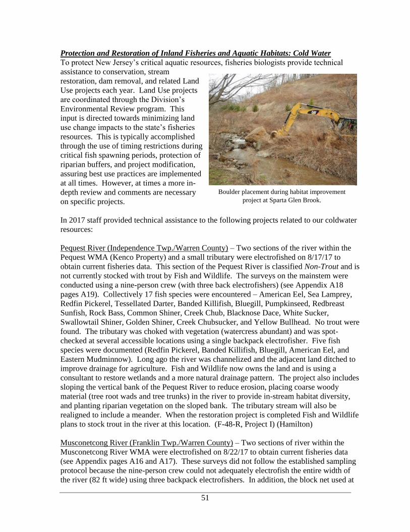
51
Protection and Restoration of Inland Fisheries and Aquatic Habitats: Cold Water
To protect New Jersey’s critical aquatic resources, fisheries biologists provide technical
assistance to conservation, stream
restoration, dam removal, and related Land
Use projects each year. Land Use projects
are coordinated through the Division’s
Environmental Review program. This
input is directed towards minimizing land
use change impacts to the state’s fisheries
resources. This is typically accomplished
through the use of timing restrictions during
critical fish spawning periods, protection of
riparian buffers, and project modification,
assuring best use practices are implemented
at all times. However, at times a more in-
depth review and comments are necessary
on specific projects.
In 2017 staff provided technical assistance to the following projects related to our coldwater
resources:
Pequest River (Independence Twp./Warren County) – Two sections of the river within the
Pequest WMA (Kenco Property) and a small tributary were electrofished on 8/17/17 to
obtain current fisheries data. This section of the Pequest River is classified Non-Trout and is
not currently stocked with trout by Fish and Wildlife. The surveys on the mainstem were
conducted using a nine-person crew (with three back electrofishers) (see Appendix A18
pages A19). Collectively 17 fish species were encountered – American Eel, Sea Lamprey,
Redfin Pickerel, Tessellated Darter, Banded Killifish, Bluegill, Pumpkinseed, Redbreast
Sunfish, Rock Bass, Common Shiner, Creek Chub, Blacknose Dace, White Sucker,
Swallowtail Shiner, Golden Shiner, Creek Chubsucker, and Yellow Bullhead. No trout were
found. The tributary was choked with vegetation (watercress abundant) and was spot-
checked at several accessible locations using a single backpack electrofisher. Five fish
species were documented (Redfin Pickerel, Banded Killifish, Bluegill, American Eel, and
Eastern Mudminnow). Long ago the river was channelized and the adjacent land ditched to
improve drainage for agriculture. Fish and Wildlife now owns the land and is using a
consultant to restore wetlands and a more natural drainage pattern. The project also includes
sloping the vertical bank of the Pequest River to reduce erosion, placing coarse woody
material (tree root wads and tree trunks) in the river to provide in-stream habitat diversity,
and planting riparian vegetation on the sloped bank. The tributary stream will also be
realigned to include a meander. When the restoration project is completed Fish and Wildlife
plans to stock trout in the river at this location. (F-48-R, Project I) (Hamilton)
Musconetcong River (Franklin Twp./Warren County) – Two sections of river within the
Musconetcong River WMA were electrofished on 8/22/17 to obtain current fisheries data
(see Appendix pages A16 and A17). These surveys did not follow the established sampling
protocol because the nine-person crew could not adequately electrofish the entire width of
the river (82 ft wide) using three backpack electrofishers. In addition, the block net used at
Boulder placement during habitat improvement
project at Sparta Glen Brook.

52
the upstream survey boundaries only blocked a portion of the river width and partially failed
during both surveys due to the swiftness of the current. These factors allowed fish,
especially larger fishes, to elude capture. Consequently, the surveys provide qualitative fish
data (i.e. fish species present) and do not reflect the overall number of fish present in the
sections surveyed. Species collected (2 surveys combined) included American Eel (143),
Blacknose Dace (99), Cutlip Minnow (56), Tessellated Darter (26), White Sucker (20),
Longnose Dace (14), Redbreast Sunfish (5), Brown Trout (2), Rainbow Trout (1), Creek
Chub (2), and Rock Bass (1). Of the trout captured, none were considered young-of-the-year
fish. The Rainbow Trout was a stocked (hatchery origin) fish (10.7 in.) and the smaller of
the two Brown Trout (7.6 in.) was considered a wild trout. The origin (wild or hatchery) of
the other Brown Trout (9.6 in.) was unclear. Although anglers have reported catching small
trout (5 – 6 in.) in this area, which suggests trout may be reproducing in the river (classified
Trout Maintenance), the survey data was inconclusive in this regard. The lack of deeper
pools was noted and anglers fishing slightly downstream in private club waters commented
that the trout stocked by Fish and Wildlife on the state property quickly find their way into
their private stretch (where an in-stream habitat project was completed over five years ago).
Trout Unlimited proposed a habitat enhancement project within this WMA and hired a
stream restoration consultant to design and implement the project, subject to Fish and
Wildlife approval and issuance of Land Use Regulation permits. (F-48-R, Project I)
(Hamilton)
Rinehart Brook - Brook Trout Restoration Project
A Brook Trout restoration project was initiated on Rinehart Brook, a tributary to the Black
River within Hacklebarney State Park. The non-native Brown Trout has become the
dominant trout species and the native Brook Trout reside in small numbers. The objectives
of this study were: to determine if multiple depletion electrofishing could be an efficient
manner to remove Brown Trout, to monitor potential rebound effects of the Brook and
Brown Trout populations, and to determine if natural boulder waterfalls prevent Brown Trout
from recolonization. Capture and removal of Brown Trout were accomplished via multiple
electrofishing passes from August 23 to October 3, 2017.
Approximately two miles of Rinehart
Brook and approximately 0.5 miles of
an unnamed tributary were initially
electrofished. Rinehart Brook was
divided into six sections that could be
electrofished either consecutively or at
different times (see Appendix pages
A55 and A56). The sections will be
described from downstream to
upstream. The first section started at
the mouth of the Black River and ended
at a waterfall what was later described
as a potential barrier to fish movement
(see photo). The second continued
upstream to the beginning of a
standardized 150-m stretch that has Potential barrier to fish movement.

53
been surveyed for several years as part of a study that aims to better understand the
relationship of temperature with various measures of wild trout populations. The third
section was the standardized 150-m stretch (so that it could be compared with trout numbers
from previous surveys). The fourth section was the longest and continued to a small dam
upstream of Hacklebarney Road. The fifth section continued upstream to Old Farmers Road.
An unnamed tributary (Rinehart Brook) (Trib)(Fairmont) converges with Rinehart Brook just
upstream of Hacklebarney Road. This tributary was also electrofished. A total of 30 surveys
were conducted, 29 for removal and 1 to remark fish below the potential barrier. The table
below describes the numbers of both Brook and Brown Trout that were captured in each
section, followed by the percentage of all trout that were Brook Trout.
The first pass of Rinehart
Brook, started above a
potential barrier to fish
movement and revealed a
total of 725 Brown Trout
and only 58 Brook Trout
(7.4% Brook Trout). All
Brown Trout were
removed, adipose fin
clipped (identifying mark),
and released into various
sections of the Black River
or in Rinehart Brook below
the potential barrier. All
other species were returned
where they were captured.
Subsequent passes resulted in fewer Brown Trout and relatively stable numbers of Brook
Trout. By the seventh pass, only 9 Brown Trout and 60 Brook Trout were encountered
(87.0% Brook Trout). Seventy-seven Brook Trout (and no Brown Trout) were collected on
the first pass in the tributary. Additional surveys will resume in 2018, with intentions of
continuing to remove Brown Trout that were not captured during 2017. The existing Brook
Trout population will be monitored for the next year or two, to determine if they rebound in
response to a reduced/eliminated Brown Trout population. An insufficient rebound may
result in relocation of Brook Trout from neighboring Trout Brook.
Questions remain in regards to the ability of trout to traverse a series of waterfalls/plunge
pools near the stream’s confluence with the Black River. To test this, adipose fins were
removed from the Brown Trout and were transplanted below the falls in both Rinehart Brook
and the Black River. All Brown Trout are examined during subsequent removal efforts, to
determine if any marked Brown Trout are found upstream of the falls. Many marked Brown
Trout have been found below and in between the series of falls, however none have been re-
captured above the falls as of the final electrofishing survey on October 3.
Beautiful male Brook Trout captured on November 2, 2017

54
Trout species composition at multiple locations within Rinehart Brook and its tributary during seven complete
electrofishing passes to remove Brown Trout.
Pas
s #
an
d D
ate
Sp
ecie
s C
om
po
siti
on
1)
Bla
ck R
iver
co
nfl
uen
ce –
W
ater
fall
2)
Wat
erfa
ll –
Sta
rt o
f st
and
ard
su
rvey
3)
Sta
nd
ard
Su
rvey
(1
50
m)
4)
To
p o
f st
and
ard
surv
ey –
D
am a
t H
ack
leb
arn
ey R
d
5)
Dam
at
Hac
kle
bar
ney
Rd
– O
ld F
arm
ers
Ro
ad
Fai
rmo
un
t T
ribu
tary
Rin
ehar
t B
roo
k (
sect
ion
s 2-5
)
Wat
ersh
ed (
Fai
rmo
un
t
trib
uta
ry B
roo
k T
rou
t # f
rom
pas
s 1
car
ried
fo
rwar
d)
Pass
1
8/23 &
8/30/17
Brook 3 6 2 50 0 77 58 135
Brown 82 160 58 504 3 0 725 725
Total 85 166 60 554 3 77 783 783
Brook% 3.5% 3.6% 3.3% 9.0% 0% 100% 7.4% 15.7%
Pass
1.1
8/23/17
Brook 1
Brown 12
Total 13
Brook% 7.7
Pass
1.2
8/30/17
Brook 1
Brown 4
Total 5
Brook% 20
Pass
2
9/1 &
9/7/17
Brook 6 14 1 29 0 44 121
Brown 39 53 3 149 0 205 205
Total 45 67 4 178 0 249 326
Brook% 13.3% 20.9% 25.0% 16.3% 0% 17.7% 37.1%
Pass
3
9/12/17
Brook 5 8 3 39 50 127
Brown 18 8 2 92 102 102
Total 23 15 5 131 152 229
Brook% 21.7% 50.0% 60.0% 29.8% 32.9% 55.5%
Pass
4
9/13/17
Brook 6 4 53 63 140
Brown 5 0 38 43 43
Total 11 4 91 106 183
Brook% 54.5% 100% 58.2% 59.4% 76.5%
Pass
5
9/18/17
Brook 5 1 46 52 129
Brown 2 0 10 12 12
Total 7 1 56 64 141
Brook% 71.4% 100% 82.1 81.3% 91.5%
Pass
6
9/20/17
Brook 7 2 56 65 142
Brown 3 0 10 13 13
Total 10 2 66 78 155
Brook% 70.0% 100% 84.8% 83.3% 91.6%
Pass
7
10/3/17
Brook 6 1 53 60 137
Brown 1 0 8 9 9
Total 7 1 61 69 146
Brook% 85.7% 100% 86.9% 87.0% 93.8%

55
A final electrofishing survey was conducted on the lower end of Rinehart Brook on
November 2. The survey started at the confluence with the Black River and ended at the
potential barrier to fish passage, the uppermost waterfall, approximately 125 m upstream.
Brown Trout were numerous, with 121 captured. Of this total, 107 were previously clipped,
while only 14 were unclipped. The 14 unclipped Brown Trout were subsequently clipped.
One Tiger Trout (Brown x
Brook hybrid), a YOY (82
mm) was also encountered
during this collection.
Clipped fish, if recaptured
above the potential barrier
during future surveys, will
indicate that there is passage
of fish from the Black River
into Rinehart Brook. (F-48-R,
Project II) (Crouse)
Naturally born young-of-the-year Tiger Trout (82 mm) captured
from Rinehart Brook on November 2, 2017.

56
Sparta Glen Brook Restoration
Sparta Glen Brook Restoration project aims to restore a section of Sparta Glen Brook that
was devastated by a massive landslide from a microburst in August of 2000 dumping 16
inches of rain in a very short
period of time. After a partial
rebuild, the site again was
severely damaged by Hurricane
Irene in 2011. The Fred S.
Burroughs North Jersey Chapter
of Trout Unlimited has partnered
with the Township of Sparta to
restore this section of stream back
into its natural state. In the spring
of 2016, in-stream habitat
restoration was performed by a
private consultant in an attempt to
revert the stream back to what it
was prior to the two flood /
landslide events.
An electrofishing survey was done on July 12, 2017 to determine the status of the fish
population, including native Brook Trout, following restoration efforts (see Appendix page
A12). This survey was done with the knowledge that only one complete breeding cycle had
taken place since the restoration work was completed. Multiple breeding cycles should occur
before an assessment of success or failure of the restoration efforts can be determined. This
survey was done to determine if native Brook Trout are still in the area after the work was
done, and if recovery has begun. Two adult/juvenile native Brook Trout were found in 2017.
This is exactly the same number of native Brook Trout found in 2016 and 2015 and indicates
that the habitat restoration efforts did not have a negative impact on the small native Brook
Trout population found previously. Overall, the survey found 338 individual fish
representing 4 different species. The 338 individual fish found is comparable to last year
when 333 individual fish were collected.
A second electrofishing survey was done also on July 12, 2017 to determine the status of the
fish population and wild Brook Trout population upstream of the restoration area on Sparta
Glen Brook (see Appendix page A11). This survey will help establish a baseline for the
restoration area, to help measure success of the restoration efforts downstream. Two
adult/juvenile native Brook Trout were also found in this survey location. This shows that
the overall area is not doing well in terms of the Brook Trout population and that the
landslide is not the only habitat issue as this survey was done outside of the area directly
impacted by the landslide. Temperature of the stream during the survey was 21.7℃ and may
actually be the biggest limiting factor for the struggling Brook Trout population. Further
investigation on temperature would need to occur to be sure if it is the leading cause for the
low Brook Trout population. Overall, the survey found 174 individual fish representing 4
different species. (Federal Grant F-48-R, Project II) (Shramko)
One of two Brook Trout captured in 2015 within the 150-m
survey on Sparta Glen Brook

57
Spruce Run: Clean-up of Quarry Discharged Materials (Hunterdon)
During the weekend of July 29 and 30,
2017, Eastern Concrete Materials Inc.
illegally released a large amount of
sediment from their stone quarry in
Glen Gardner into Spruce Run Creek.
This Trout Production stream, a major
tributary to Spruce Run Reservoir,
supports wild Brook and Brown Trout
populations and is also trout stocked.
The sediment, composed of pulverized
granite, is produced as a waste product
from the newly quarried stone. The
sediment laden wastewater is then
collected in settling basins. After solids settle, the clear top water is permitted by NJDEP to
be discharged into the creek. Unfortunately, pumping continued to the point in which
sediment was discharged, resulting in a tremendous amount of sediment released into the
stream. A 1.7-mile section, from the quarry discharge to Spruce Run Reservoir, was
impacted. Accumulations of sediment were estimated at approximately 2-4 inches
throughout most of the stream, with most significant accumulations near the point of
discharge, with a maximum depth measured at 20 inches. Sediment samples were collected
by USGS and a determination was made that the sediments were within human health and
safety standards, however the impacts to habitat and aquatic life would be detrimental if not
adequately removed.
Various measures of water quality were taken on August 1, with no significant difference
above and below the impacted area. Parameters included water temperature, oxygen,
conductivity, specific conductance, total dissolved solids, salinity, pH, and alkalinity.
Surprisingly, only a few dead fish including Brown Trout and amphibians such as Pickerel
Frogs were reported.
Photo taken of Spruce Run (Creek) looking upstream
from Van Syckles Bridge on Sunday July 30, 2017.
Handful of fine sediment (pulverized granite) scraped off the streambed of Spruce Run (left).
Dead young-of-the-year Brown Trout found in Spruce Run during initial inspection by NJDFW (right).

58
Two electrofishing surveys were conducted
on August 1 to determine if the fish
assemblage had survived the initial impact
(see Appendix pages A60 and A61). The
first survey was conducted in a 150-m
section immediately downstream of the
discharge and a second 150-m site was
sampled approximately 1 mile further
downstream. An abundance of wild Brown
Trout, including young-of-the-year (YOY),
were found at both sites (68 and 52
respectively). A few stocked Rainbow
Trout (10 and 3 respectively) and one wild
Brook Trout YOY were also found at each
site. Other common fish species were
encountered as well. Numbers of fish
collected were likely underestimated, due
to decreased visibility in the turbid water. A healthy fish assemblage was found at both sites,
however without a rapid cleanup effort, it was anticipated that they would not survive in the
short-term, due to starvation (anticipated loss of aquatic insects over time due to sediment)
and/or will not be able to adequately spawn. Spawning would be impacted by the
inundations of suitable spawning substrate (gravel) with fine sediment, shifting of sediment
smothering eggs/redds (nests), and curtailed movement of fish due to extensive sediment.
NJDFW determined a fish salvage was not necessary and electrofishing surveys will be
duplicated during the summer of 2018 to assess the status and recovery of the fishery.
NJDEP’s Bureau of Freshwater and Biological Monitoring conducted three
macroinvertebrate surveys on August 10. Surveys indicated the macroinvertebrates appeared
to be relatively abundant with a variety of species including Stoneflies and Mayflies,
resulting in scores of 66.32 and 69.29 (both Excellent) and a score upstream of Van Syckles
Road of 58.85 (Good). This initial information was hopeful, that a food supply was
present, but it was uncertain how long the macroinvertebrates would survive with extensive
sediment, over an extended period of time. Surveys were repeated on November 28, yielding
scores of 70.37, 66.90, 65.87 respectively, all considered Excellent and 2 of which had
improved since the August 10 surveys. The prognosis based on these surveys was good.
Initially, three sediment curtains were installed near
the inlet at Spruce Run Reservoir and a series of
seven check dams were installed along the stream
to slow velocities, to accumulate sediment in the
pools above the dams. Vacuum trucks began to
remove material on August 10. Two vacuum
trucks, each with a capacity of 3,750 gallons
discharged the slurry back into the quarry settling
basins. The pace of the clean-up improved when a
company specializing in stream restoration utilized
an innovative approach to clean up sediment-
One of two electrofishing surveys conducted on
August 1, 2017 to determine status of existing fishery
2 days after sediment was released into Spruce Run.
Equipment used to vacuum sediment from
streambed.

59
impacted habitats in rivers and streams was hired following their on-site evaluation on
August 21. They had the expertise to vacuum sand and sediment from the impacted
streambed, leaving the native gravel and cobble substrates. They trained local contractors to
implement their techniques. Trash pumps were used to “power-wash” the material, to
consolidate it for removal. The NJ Water Supply Authority was concerned with materials
entering Spruce Run Reservoir, an important water supply reservoir. Therefore, additional
sediment curtains were installed to prevent additional transport of material into the reservoir.
A substantial amount of sediment was removed, using heavy equipment, in the inlet of
Spruce Run Reservoir.
It was important to minimize environmental impacts to the 1.7 miles of Trout Production
section upstream. As a result, several proactive steps were taken, including the prohibition of
heavy equipment use in the streambed and precautions to protect the State Threatened Wood
Turtle to name a few. A turtle monitor was hired to observe and clear construction areas.
Silt fencing and hay bales were installed at the access points to minimize turtle movement
into the area.
The cleanup portion of the restoration of Spruce Run and Spruce Run Reservoir was
completed on November 29. Sediment was removed from the entire 1.7 miles that were
impacted, in addition to the removal of material from the forebay of Spruce Run Reservoir.
The cleanup progressed slowly at first, however techniques were refined and progressed
more rapidly midway through the clean-up. All six check dams and all sediment curtains
were removed, allowing mature trout to make upstream movements for spawning. All access
roads have been removed and all soil disturbances were planted with native vegetation. A
settlement in principal has been reached. The stream, riparian area, and its inhabitants will
continue to be monitored. (Hunter Angler Fund) (Crouse)
Photographs taken before and after the clean-up of
Spruce Run: days after discharge (left) and after
clean-up (right).

60
West Portal Creek: Brook Trout Restoration Project (Hunterdon County) - A catastrophic
fish kill occurred on May 5, 2016 in West Portal Creek, a Trout Production tributary to the
Musconetcong River. The clean-up associated with a truck fire on Interstate 78 resulted in
detergent (truck’s cargo) washing into the creek, killing thousands of fish in a 2.8-mile
section from the I-78 overpass downstream to the Musconetcong River. Prior to the fish kill
the wild trout population in the creek had been dominated by Brown Trout and wild Brook
Trout were very sparse. Brook Trout, the only trout species native to New Jersey, is in
decline statewide and may soon be designated state Special Concern. Slimy Sculpin (soon to
be listed state Threatened) also resided in this coldwater stream. Following the fish kill, the
Bureau began actively managing this stream for native fishes, with the emphasis on restoring
wild Brook Trout by removing the non-native Brown Trout, which directly compete with
Brook Trout for cover, food, and spawning habitat. This restoration project (the first of its
kind for wild Brook Trout in New Jersey) is using an adaptive management approach,
whereby decision-makers learn and gain new insights from data as it is collected and adjust
strategies to achieve the outcome desired.
In 2016 multiple electrofishing surveys were conducted both upstream and downstream of
the I-78 bridge in to assess the recovery of native fishes, while simultaneously removing non-
native salmonids (Appendix A21 -A22) . A total of 49 wild Brown Trout, plus 2 Rainbow
Trout and 1 Tiger Trout (a sterile hybrid of Brook and Brown Trout) presumably stocked in
the Musconetcong River, were removed. Native species encountered were returned to the
creek, including 24 wild Brook Trout and other species (Slimy Sculpin, American Eel,
Blacknose Dace, Longnose Dace, Creek Chub, White Sucker, and Common Shiner).
Although the number of Brook Trout that remained was low, it was theorized that a sufficient
number remained that could reproduce successfully (particularly if Brown Trout were absent,
or nearly so) and eventually repopulate the stream. Transference of wild Brook Trout from
another nearby Musconetcong River tributary to West Portal Creek was considered, but not
undertaken to avoid mixing gene pools.
In 2017 ten electrofishing surveys were conducted to assess the reproductive success and
status of the wild trout population in West Portal Creek and remove Brown Trout. The entire
length of the creek (upstream and downstream of I-78) was surveyed once with the exception
of a section that could not be electrofished due to dense overhanging riparian vegetation. In
addition, two standard surveys were conducted to replicate those conducted in 2016. A total
of 1,527 trout were captured including 1,239 Brown Trout, 224 Brook Trout, and 64 Tiger
Trout. The data indicates that Brown Trout continue to outnumber Brook Trout (5:1 ratio).
Other species captured during these surveys included Creek Chub, Blacknose and Longnose
Detergent in West Portal Creek, May 5 Same location, May 6 Representative aquatic organisms killed

61
Dace, Tessellated Darter, American Eel, White Sucker, and Slimy Sculpin. These species
were generally not very abundant, especially Slimy Sculpin.
Nearly all (97%) of the trout captured in the 2017 surveys were young-of-the-year, which
indicates that both Brook and Brown Trout reproduced there last fall. The presence of Tiger
Trout, which indicates mating success between Brook Trout (typically males) and Brown
Trout (typically females), is cause for concern as this suggests mature female Brook Trout
are scarce. Brown Trout will likely continue to be the dominate trout species in this stream
unless they can be completely eradicated. This would be a decidedly uphill battle unless an
instream barrier could be built on the creek near its confluence with the Musconetcong River
to prevent wild Brown Trout from nearby tributaries (such as Turkey Hill Brook) from
entering and recolonizing West Portal Creek.
Although the outlook for Brook Trout in West Portal Creek appears bleak given the
dominance of Brown Trout, it may be possible to establish a viable population upstream of
the I-78 culvert where relatively few Brown Trout were found (and removed) in 2016 and
only one Tiger Trout was found there in 2017. The culvert is perched which may be
beneficial in preventing or discouraging Brown Trout from migrating upstream to spawn.
Establishing a wild Brook Trout population in this headwater reach while Brown Trout are
still absent, by transferring wild fish from a nearby stream, may help avert extirpation of
Brook Trout from West Portal Creek. It is recommended that additional surveys be
conducted in 2018 to assess the status of the recovering trout population and determine if
Brook Trout restoration should be pursued and to add to our knowledge base as other Brook
Trout Restoration projects in New Jersey are considered. (F-48-R, Project II) (Hamilton)
Results of 10 electrofishing surveys conducted in 2017 on West Portal Creek, Hunterdon County, New Jersey.
The number of trout outside parentheses indicates young-of-the year (YOY); the number inside parentheses
indicates fish older than YOY.
Sample Wild trout species
Stream reach - upstream to downstream Date length (m) Brook Brown Tiger
Nonstandard surveys (survey length varies)
H - Headwaters to Bellwood Park Road 8/2/17 675 - - -
G - Bellwood Park Road to I-78 culvert 8/2/17 370 - - 1 (0)
F - I-78 to wood line above Ridge Road 8/2/17 124 - - -
Wood line above Ridge Road to Ridge Road Not surveyed
E - Ridge Road to Asbury-West Portal Road 7/28/17 725 25 (4) 417 (22) 63 (0)
D - Asbury-West Portal Road to Valley Station
Road
7/26/17 834 95 (3) 469 (5) -
C - Asbury-West Portal Road downstream to
abandoned RR trestle
7/25/17 549 78 (2) 145 (4) -
B - Abandoned RR trestle to point 2 km downstream
of Valley Station Road
7/21/17 701 6 (0) 48 (5) -
A - Point 2 km downstream of Valley Station Road
Start to confluence with Musconetcong River
7/21/17 914 0 (1) 2 (0) -
Standard surveys (survey length 150 m)
Asbury-West Portal Road (start 100 m downstream) 7/20/17 150 10 (0) 119 (0) -
Asbury-West Portal Road (start 2 km downstream) 7/20/17 150 - 3 (0) -
214 (10) 1,203 (36) 64 (0)

62
COOLWATER / WARMWATER FISHERIES
Coolwater Fisheries Management
In 2016 a three-year initiative (2014-2016) was completed to assess the stocking of coolwater
species such as Muskies, Northern Pike, Walleye and Hybrid Striped Bass. These species do
not readily reproduce in New Jersey waters and are maintained by annual stocking programs
from Fish and Wildlife’s Hackettstown State Fish Hatchery. The initiative included a review
of management goals and objectives, plus an assessment of current fisheries. The assessment
also included an online angler survey concerning angler opinions and experiences on their
warmwater/coolwater fishing opportunities in New Jersey. Over 1,000 anglers participated.
A significant part of the coolwater assessment was data collection. To assess the status of
these populations, trap nets were set, the most efficient means of capturing these species.
Over the course of the study, the Bureau set 273 trap nets, 13 gill nets, and conducted 17
days of electrofishing - over 251 man-days of work. In 2017, significant changes to the
State's Coolwater Program were made based on
study results. Regulation changes were proposed
and formally adopted following a 60-day public
comment period. These regulations became
effective on February 10, 2018. Sampling findings
for each individual waterbody and management
recommendations can be found in the final report
titled Assessment and Management of New
Jersey’s Stocked Coolwater Fishes (Appendix G).
(F-48-R, Project II) (Collenburg)
The following are changes to the State’s Coolwater
stocking program:
Muskellunge
• Statewide size limit for Muskellunge increased from 36 to 40 inches
74% of captured individuals (77) were larger than 36", and 25% were at least or
greater than 44".
• Minimum size for Trophy Musky Waters increased from 40 to 44 inches
- 40 to 70% of the individuals captured were over 40", 20 to 26% exceeded 44"
- Lake Hopatcong and Monksville Reservoir added as Trophy Musky Waters
- Mountain Lake no longer regulated as Trophy Musky Water.
• Spring yearlings were added to the program and will be stocked in alternating years
from fall fingerlings.
- Stocking yearlings in other states has significantly increased survivability.
- Studies indicate short-term survival rates of fingerlings (37.7-3.87%).
• Stock Tiger Muskellunge at 0.2/acre in each waterbody receiving Muskies.
- Lake Musconetcong will only receive Tiger Muskellunge, at a rate of 2/acre.
Echo Lake Musky (50.2 in. / 33.1 lbs.
brought back to Hackettstown State Fish
Hatchery for brookstock

63
New stocking rates on waterbodies receiving Muskellunge. Lake Musconetcong was just added to the program
and will be stocked with Tiger Muskellunge only at a rate of 2, 10” FF/acre (green).
• Two Waterbodies added to the Muskellunge/Tiger Musky Stocking Program
- DOD Lake – A 120-acre impoundment in Salem County, Muskellunge have been
stocked here in the past, but not on a consistent basis.
- Lake Musconetcong – A 329-acre lake in Morris County, Tiger Muskellunge will be
stocked on an annual basis to add an additional opportunity for anglers (see table
above).
• Annual stocking ceased at two non-producing waters
- Despite aggressive stocking fisheries have failed to develop at Carnegie Lake and
Manasquan Reservoir.
- Manasquan will receive hatchery surplus when available
• Stocking rate reduced in select water with over abundant Muskellunge Population
- An overly abundant population of Muskellunge exists in Mountain Lake. Current
stocking rates have been somewhat consistent, but survivability may be high or
maybe natural reproduction is occurring and increasing recruitment. Aside from the
current Muskellunge population large predators are not common in Mountain Lake
and may contribute to the higher survivability of Muskellunge. The fishery is limited
by the lack of the once
abundant forage base of
Yellow Perch and Creek
Chubsuckers and a stunted
population of Bluegills. The
fishery is unbalanced.
Muskellunge are not able to
reach a size of 40 inches and
are stunted based on age-
length analysis. The stocking
rate will be decreased and
focus should be on improving
habitat for forage fish.
46.9 in. and 29 lbs. Musky from Monksville Reservoir

64
Northern Pike
• Annual stocking ceased at two non-producing Northern Pike waters
- Angler satisfaction and trap net data indicate that the Northern Pike population at
Cranberry Lake and Deal Lake is low in abundance.
- Both locations will be used for surplus when available
- The online Warmwater/Coolwater angler survey indicated it is underutilized with
91.4% indicating they never fished it for pike.
• Increase stocking rate of Northern Pike on a select water
- Pompton Lake - Trap net catch rates indicated the population in low to moderate
abundance. The abundant forage indicates this fishery can support larger numbers of
pike and good habitat exists. The stocking rate will be increased from 10/acre to
15/acre for 4-6" fingerlings.
• Reduce stocking rate of Northern Pike on select waters
- Budd Lake – Many pike are reaching the stock size of 21 inches, but rarely exceed
27 inches (high PSD and low PSDp). The population is abundant but appears to be
stunted, with a stunted forage base. Reducing numbers should increase overall size.
- Passaic River – One of the most
popular Northern Pike fisheries in the
state, anglers commonly report pike
weighing up to 20 lbs. and over 40-
inches. Online angler survey
satisfaction levels for Northern Pike in
the Passaic River exceeded all other
waterbodies by almost double.
Electrofishing surveys show poor
condition (low relative weights) of
individuals captured as well as limited
forage base. It has been heavily
stocked in the past and stocking should
be decreased to avoid failure of this
fishery.
Spruce Run Northern Pike measuring 30.1
inches and weighing 7.3 lbs.

65
Walleye
• Coordinate stocking rates for Walleye in Greenwood Lake with NYDEC
- Sampling in 2017 revealed a
highly abundant population of
Walleye (25/hr) during 6 hours of
electrofishing conducted by both
NYDEC and NJDFW.
Largemouth Bass were low in
abundance and have not recovered
since 2002 when Largemouth Bass
Virus caused a decline in the
population. Supplemental stocking
of Largemouth Bass has been
ongoing since 2012 and over
60,000 2-inch fingerlings have
been stocked.
• Established a consistent stocking rate of 20 Walleye/acre (80/20 ratio)
- Stabilization of the stocking rate will allow biologists to better evaluate the fisheries.
New Stocking rates on waterbodies receiving Walleye.
Waterbody Acres Stocking New Stocking
Rate
Pond
Fingerlings
(1-2")
Advanced
Fingerlings (2-
4")
Canistear Reservoir 350 Maintain 20/acre (80:20) 5,600 1,400
Greenwood Lake 1,920 Maintain 20/acre (80:20) 30,720 7,680
Lake Hopatcong 2,685 Maintain 20/acre (80:20) 42,960 10,740
Monksville Reservoir 505 Maintain 20/acre (80:20) 8,080 2,020
Swartswood Lake 494 Maintain 20/acre (80:20) 7,904 1,976
Walleye (26.7 in. and 6.8 lbs.) from Greenwood Lake

66
General Fisheries Surveys
Northern Pike Electrofishing Surveys on Passaic River - Beginning in 2000, the Passaic
River has received 2,200 six-inch fingerling Northern Pike, annually. It also receives
additional surplus pike, ranging in size from two to four inches. The pike are stocked at
more than 25 locations from the Lower Chatham Bridge at the Morris-Essex County line to
Pennington Park in Paterson. Locations from Hawthorne to Garfield, above the Dundee Dam
on the Bergen County side of the river, are also stocked. This fishery has become very
popular, with anglers reporting pike weighing up to 20 pounds and measuring in the low 40-
inch range. Sampling was conducted in 2017 to quantify the pike’s population in the river.
The below three sampling sites were chosen for their access (boat ramp) and will be
resampled in future years. (Hunter and Angler Fund)
A boat electrofishing (0.82 hours) survey was conducted on the Passaic River, Florham Park
on 9/28/17. The fish assemblage consisted of 12 species including Northern Pike (2), Black
Crappie (17), White Perch (15), Yellow Perch (25), Common Carp (45), Common Shiner
(500), Brown Bullhead (10), American Eel (5), Bluegill (10), Pumpkinseed (20), Green
Sunfish (2), and Redbreast
Sunfish (25). The length range
of the Northern Pike was 327 –
545 mm (12.9 – 21.5 in.). The
weight range of the Northern
Pike was 0.22 – 0.642 kg (0.49
– 1.42 lb.). The relative
weights (59 and 99) of the two
Northern Pike collected
indicate that one was of sub-
optimal weight for its length,
while the other was of optimal
weight for its length.
A second boat electrofishing (1.80 hours) survey was conducted on the Passaic River,
Fairfield on 9/28/17. The fish assemblage consisted of eight species including Northern Pike
(3), Brown Bullhead (7), Yellow Perch (15), White Perch (25), Largemouth Bass (3), Redfin
Pickerel (5), Pumpkinseed (25), and Bluegill (20). The length range of the Northern Pike
was 377 – 624 mm (14.9 – 24.6 in.). The weight range of the Northern Pike was 0.25 –
1.548 kg (0.55 – 3.41 lbs.). The relative weights (72, 80 and 93) of the three Northern Pike
collected indicate that all three were of sub-optimal weight for their length.
A third boat electrofishing (0.82 hours) survey was conducted on the Passaic River,
Hawthorne on 10/19/17. Low water conditions limited the length of river sampled. The fish
assemblage consisted of 9 species, including Northern Pike (1 captured, 2 observed / evaded
capture), Common Carp (65), Brown Bullhead (10), American Eel (6), Largemouth Bass (3),
Rock Bass (1), Smallmouth Bass (2), Redbreast Sunfish (25), and White Sucker (7). The
length of the Northern Pike was 624 mm (24.6 in.). The weight of the Northern Pike was
1.56 kg (3.4 lbs.). The relative weight (94) of the Northern Pike collected indicate that it was
of sub-optimal weight for its length.
Passaic River Northern Pike

67
Nineteen of the twenty-three Northern Pike collected / observed in 2015 – 2017 were of sub-
optimal weights for their lengths. Additionally, the majority of angler catch photos of
Passaic River Northern Pike appeared to be of sub-optimal weights for their lengths. The
stocking of surplus Northern Pike in the Passaic River should be discontinued. Annual
electrofishing surveys will continue to be conducted at the above three sites to continue to
monitor the fishery. (Hunter and Angler Fund) (Boriek)
Lake Inventories
Successful management of New Jersey’s warm and cool water fisheries resource is based
upon specific knowledge of their physical, chemical, biological, and use characteristics.
Such knowledge may serve to direct immediate management recommendations or be used as
a baseline, upon which to recognize future changes, requiring remedial management efforts.
Under this activity physical, chemical, and biological data is collected utilizing standard
sampling techniques. Physical parameters include morphometry, bathymetry, access,
watershed, and aquatic vegetation characteristics. Chemical parameters include general
water chemistry and sediment nutrient characteristics. Biological parameters include fish
species composition, abundance (catch-per-unit-effort), length frequency distribution, and
calculated indices of population structure and dynamics such as proportional stock density
(PSD), relative weight (Wr), age, and growth. The data are analyzed and results are used to
develop management recommendations and prepare an individualized fisheries management
plan for the waterbody. These plans are summarized and published for dissemination to the
angling public. (Federal Grant F-48-R, Project I)
No lake inventories were conducted in 2017, however a total of 35 boat electrofishing
surveys were completed at 24 locations in 2017 (see below). (Smith)

68
Warmwater Fisheries Assessments via Electrofishing
New Jersey has over 400 impoundments open to the general public for fishing and thousands
more in private ownership scattered throughout the state. These lentic environments offer
excellent fishing opportunities for a variety of species such as bass, sunfish, crappie, and
pickerel. These species naturally reproduce in the waterways and often do not require active
stocking to sustain their populations. The Bureau of Freshwater Fisheries conducts
abbreviated fisheries surveys on lakes and ponds throughout the state to assess the status of
popular game species, compared to full inventories on others. Electrofishing surveys are
conducted at various waterbodies throughout the state to assess the current status of the bass
populations. Lakes are assessed based on the catch per unit effort (CPUE) for stock size fish
(Largemouth Bass ≥ 8 in.) as determined from the electrofishing survey. CPUE is a measure
of the number of fish caught per hour. Fish populations are further evaluated utilizing stock
density indices that provide a numerical descriptor of length-frequency data. These indices
include PSD, PSD-P, and PSD-M (formerly PSD, RSDp, and RSDm). Calculations for each
parameter are made to determine a proportional size distribution of certain size fish that is
within the stock size. The PSD-P is simply the percentage of fish sampled greater than the
“preferred” size (Largemouth Bass ≥ 15 in.). Standard lengths are used for each species.
The PSD-M is the percentage of fish sampled greater than the “memorable” size
(Largemouth Bass ≥ 20 in.). Sampling results are used to determine if supplemental
stockings or adjustments to current regulations are necessary.
A total of 35 surveys were completed at 24 locations in 2017. Assunpink Lake had the
highest CPUE for Largemouth Bass at 60 bass/hr during daytime electrofishing. The largest
bass encountered electrofishing this year was from Perrineville Lake on May 4 and weighed
6.99 lbs. Followed by a bass weighing 6.72 lbs. collected at Union Lake on February 27.
(Hunter and Angler Fund)
Assunpink Lake (Monmouth) – Assunpink Lake is a 225-acre impoundment located within
the Assunpink WMA, Upper Freehold Township. The lake is one of the five waterbodies
managed as a Lunker Bass Lake and one of the most utilized Wildlife Management Areas in
the state. Two daytime electrofishing surveys were completed in 2017. An electrofishing
survey was completed on April 24, 2017 to assist pathologist Dr. Jan Lovy with the
collection of Bluegill, Pumpkinseed, and Largemouth Bass for testing as a follow-up to a
spring 2015 fill kill. Assunpink Lake has annual fish kills during the spring. Kills of varying
species have been attributed to both bacteria and parasites. Largemouth Bass were observed
in good number (n=124) and most were in good condition. A total of 1.16 hr of daytime
electrofishing was completed around the perimeter of the lake. Approximately 20 additional
Largemouth Bass were observed. These were not collected, since they were actively
spawning. Some individuals appeared to be rather thin, including females that had not yet
spawned. Not all Largemouth Bass were collected, hence a CPUE was not calculated. Three
individuals greater than memorable size (510 mm) were collected, the largest of which
measured 530 mm (20.8 in.) and weighed 2.764 kg (6.09 lbs.).
A daytime boat electrofishing survey was conducted on September 21, 2017 to assess the
Largemouth Bass population. Sampling occurred around the perimeter of the lake. A total
of 66 Largemouth Bass were collected, of which 60 were >200 mm (stock size). The CPUE
was 60 bass/hr. A PSD of 51 and a PSD-P of 15 were calculated for Largemouth Bass.

69
Total electrofishing time was 60 minutes. The Largemouth Bass population in Assunpink
Lake currently appears to be to be comprised mostly of smaller fish according to angler
reports and survey data. As these fish continue grow the bass fishery is expected to improve.
The amount of aquatic vegetation within the lake has recently increased as well. Hydrilla
and Water Chestnut both invasive aquatic vegetation species are now established in the lake.
Reasonable amounts of aquatic vegetation can improve recruitment, as it provides small fish
with a place to avoid predation, allowing for increased survival. Heavy sedimentation in the
lake has impacted the fish population. A dredging project is recommended to restore and
improve habitat. Continued monitoring of the Largemouth Bass population, and the habitat
within the lake is recommended to maintain this popular fishery. (Smith)
Cooper River Park Lake (Camden) – A boat electrofishing survey was completed at Cooper
River Park Lake on August 17, 2017 to evaluate the Largemouth Bass and Northern
Snakehead population. A total of 44 Largemouth Bass were collected in 1.68 hr of
electrofishing. There were 44 fish >200 mm stock size, indicating of CPUE of 26 bass/hr.
The PSD of 65 and PSD-P of 11 indicate the population is balanced. No additional stocking
of Largemouth Bass is recommended at this time. There were no snakeheads collected,
however a Peacock Bass, measuring 248 mm was collected and destroyed. This is the first
recorded capture of the non-native species in New Jersey. The fish was most likely released
from an aquarium and since they are considered a tropical species, it would not have survived
the cold winter temperatures. Releasing any non-native species into New Jersey waters is
illegal. Additional species collected included Striped Bass, Alewife, Common Carp, White
Catfish, Brown Bullhead, Channel Catfish, Golden Shiner, Eastern Silvery Minnow, Bluegill,
Pumpkinseed, American Eel, White Perch, and Gizzard Shad. (Smith)
Delaware River (Burlington) – A boat electrofishing survey was completed at the Delaware
River in Bordentown on August 21, 2017 to evaluate the Largemouth Bass and Northern
Snakehead population. A total of 61 Largemouth Bass were collected in 1.80 hr of
electrofishing. There were 47 fish >200 mm stock size indicating of CPUE of 26
bass/hr. The PSD of 47 and PSD-P of 14 indicate the population is balanced. No additional
stocking of Largemouth Bass is recommended at this time. Reproduction of Largemouth
Bass appears to be adequate to support the population based on the 14 individuals less the
200 mm stock size. One Smallmouth Bass measuring 475 mm and weighing 1.46 kg was
collected. There were no snakeheads collected, however one Grass Carp (weighing
approximately 40 lbs.) was collected and destroyed. Two additional Grass Carp of similar
size were observed and alluded capture. Grass Carp are a non-native species stocked in a
sterile form by permit only, in a limited number of waters that meet specific requirements, to
control aquatic vegetation. Their origin is most likely due to escapement from lakes or ponds
that connect to the Delaware River.
A boat electrofishing survey was completed at the Delaware River in Trenton on August 22,
2017 to evaluate the Largemouth Bass and Northern Snakehead population. A total of 45
Largemouth Bass were collected in 1.59 hrs of electrofishing. There were 40 fish >200 mm
stock size indicating of CPUE of 25 bass/hr. The PSD of 55 and PSD-P of 18 indicate the
population is balanced. No additional stocking of Largemouth Bass is recommended at this
time. Two Smallmouth Bass measuring 256 and 277 mm, weighing 0.210 and 0.266 kg were
collected. There were no snakeheads collected, however two adult snakeheads were

70
observed. Channel Catfish were abundant and of large size which should provide an
excellent fishery for anglers fishing the river.
A boat electrofishing survey was completed at the
Delaware River in Burlington on August 24, 2017 to
evaluate the Largemouth Bass and Northern
Snakehead population. A total of 87 Largemouth Bass
were collected in 1.90 hr of electrofishing. There were
70 fish >200 mm stock size indicating of CPUE of 36
bass/hr. The PSD of 56 and PSD-P of 4 indicate the
population is unbalanced. No additional stocking of
Largemouth Bass is recommended at this
time. Seventeen Largemouth Bass below the stock
size were collected indicating good recruitment. There
were no snakeheads observed or collected.
A boat electrofishing survey was completed at the
Delaware River in West Deptford on August 28, 2017
to evaluate the Largemouth Bass and Northern
Snakehead population. A total of 14 Largemouth Bass
were collected in 1.66 hr of electrofishing. There were
12 fish >200 mm stock size indicating of CPUE of 7 bass/hr. Two snakeheads, measuring
720 and 340 mm, were collected. Northern
Snakeheads are considered an invasive
species and as such both were destroyed.
Continued sampling is recommended to
monitor the Largemouth Bass fishery and
Northern Snakehead population. Additional
species observed included Striped Bass, YOY
Alewife and Blueback Herring, YOY
American Shad, Menhaden, Common Carp,
Channel Catfish, Golden Shiner, Bluegill,
Pumpkinseed, American Eel, White Perch,
and Gizzard Shad. No Atlantic Sturgeon, a
federally listed endangered species, where
observed during sampling. (Smith)
DOD Lake (Salem) – The DOD Lake WMA is a 120-acre borrow pit located in Penns Grove.
A lake inventory and management plan was completed in 2002. The Largemouth Bass
population has fluctuated since acquisition by NJDFW in 1999. Boat electrofishing surveys
to monitor the Largemouth Bass population were completed in 2010, 2011, 2014, 2015,
2016, and again in 2017. DOD Lake has received surplus stockings of Smallmouth Bass,
Channel Catfish, Tiger Musky, and Musky since 2013. These stockings are not part of the
annual stocking schedule. None of the stocked species listed above were encountered during
sampling in 2017, however the stocking of these species should continue in order to increase
diversity of the fish population and provide anglers additional fishing opportunities. A boat
Striped Bass caught by electrofishing the
Delaware River in 2017.
Striped Bass caught by electrofishing
the Delaware River in 2017.

71
electrofishing survey was completed on August 4, 2017 to evaluate the Largemouth Bass and
Northern Snakehead population. A total of 70 Largemouth Bass were collected in 1.75 hr of
daytime electrofishing. There were 60 bass greater than the 200 mm (8 in.) stock size
indicating a CPUE of 34 bass/hr. The PSD was 35 and PSD-P was 15 indicating the
population is slightly unbalanced. Northern Snakeheads were first reported in 2014 and their
presence was confirmed by NJDFW in 2015. Three Northern Snakeheads were collected
during this survey, measuring 382 - 482 mm (15.1 – 18.9 in.). In comparison two Northern
Snakeheads were collected in 2015 and eight in 2016. Northern Snakeheads are managed as
an invasive species and all were destroyed. The snakehead population will continue to be
monitored to determine the impact on the Largemouth Bass population. (Smith)
Egg Harbor Township Nature Reserve Lake (Atlantic) – Egg Harbor Township Nature
Reserve Lake is a 29-acre waterbody located within Egg Harbor Township. The lake is
located within the 220-acre Egg Harbor Township Nature Reserve and is an old sand quarry.
A daytime boat electrofishing survey at the request of the Nature Reserve board members
was conducted on August 2, 2017 to assess the Largemouth Bass population. Total
electrofishing time was 4,368 seconds (72 minutes). A total of 17 Largemouth Bass were
collected which ranged in size from 185 mm to 480 mm (7.3 – 18.9 in.), of which 16 were
>200 mm (8 in.) stock size. A Largemouth Bass measuring 480 mm (18.9 in.) and weighing
1.632 kg (3.60 lbs.) was the largest collected during the survey. A total of 37 Pumpkinseed,
and 9 young-of-the-year (YOY) Largemouth Bass were also collected during electrofishing.
Increased angling pressure can have a negative impact on easily exploitable fish populations
in recently made public waters. Artificial habitat, such as brush piles, may be beneficial to
the fishery as well. 500 adult Bluegill and 1,125 fingerling Largemouth Bass were stocked
on August 15, 2017 to enhance the fishery. Seining (page 89) and a DO/Temp profile (page
143) were also conducted. (Boehm)
Etra Lake (Mercer) – A boat electrofishing survey was completed on October 31, 2017 at
Etra Lake, located in East Windsor to evaluate the Largemouth Bass population. No recent
electrofishing surveys have been completed for the waterbody. A total of 21 Largemouth
Bass were collected in 0.53 hr of electrofishing which translates to a CPUE of 39 bass/hr of
stock size bass. This, however, is rather misleading, since the entire perimeter of the lake
was sampled in less than an hour. Even though the CPUE suggests a robust population, the
size of the lake (less than 10 acres), limited habitat, and presence of water-chestnut restricts
the potential to expand the population. No additional stocking of Largemouth Bass is
recommended. There is limited shoreline access and launching of trailered vehicles appears
to be discouraged based on signs in the parking area. One Tilapia was collected and
destroyed. Several others were observed, but avoided collection due to dense aquatic
vegetation. Water Chestnut was also documented in Etra Lake for the first time during this
survey. (Smith)
Farrington Lake (Middlesex) - A daytime boat electrofishing survey was conducted in
Farrington Lake (223 ac) and Selover’s Millpond (3 ac) on May 23, 2017 to check
Largemouth Bass for possible PCB toxicity. A hydraulic fluid spill occurred in Selover’s
Millpond, an onstream impoundment of the Lawrence Brook in October 2016. It was
determined that high PCB levels were detected and as a result, the Division closed a 1.6-mile
section of Lawrence Brook, from Riva Avenue bridge down to Ryders Lane. In order to

72
determine if the fish are healthy to eat, 10 Largemouth Bass were collected from the site of
the spill (Selover’s Millpond) and 10 were collected from Farrington Lake (upstream to serve
as a control). Live fish were provided to the Division’s fish pathologist Jan Lovy, who
prepared the fish tissue and sent it out to a private laboratory for PCB analysis, that
determined PCB levels in the fish tissue were at safe levels.
It took 1,437 seconds (0.4 hr) to collect 10 legal (greater
than 12 in.) Largemouth Bass. They ranged from 309 -
417 mm (12.2 – 16.4 in.) the largest of which weighed
1.250 kg (2.8 lbs.). The largest bass exhibited a
characteristic known as “melanism,” in which an
accumulation of pigment occurs in the superficial tissue,
presenting distinct black blotches all over the fish.
Although believed to be non-harmful, some believe the
melanistic tissue may be a precursor to a form of skin
cancer. This specimen and two others from Selover’s
Millpond were retained and dissected by Dr. Lovy. It
was determined that the blotches were very superficial
(with no penetration into the muscle tissue) and not
indicative of any concerns of malignancy. Other fish
species observed included Bluegill, Pumpkinseed, White
Perch, Yellow Perch, Brown Bullhead, Common Carp,
and Alewife. No additional fish tissue surveys are
necessary at this time. (Crouse)
Game Creek (Salem County) – A boat electrofishing survey was completed at Game Creek, a
tributary of the Salem River located in Carneys Point on November 1, 2017 to evaluate the
Largemouth Bass and Northern Snakehead populations. Northern Snakeheads were first
documented in Game Creek in 2016. A total of seven adult snakeheads ranging from 395 –
690 mm (15.6 – 27.2 in.) were collected, and destroyed.
Approximately 8-10 additional snakeheads were
observed and avoided capture due to the dense emergent
vegetation along the shoreline.
A total of 69 Largemouth Bass were collected during 2.0
hr of electrofishing. The CPUE of 33 bass/hr for stock
size bass indicates a good population density. The PSD
of 62 and PSD-P of 28 indicate the population is
balanced. The largest bass collected measured 530 mm
and weighed 2.71 kg. Stocking a supplemental YOY
Largemouth Bass should be stocked on a bi-annual basis
to offset the impacts of tournament mortality. Stocking
should be completed at a stocking rate of 25/acre.
Monitoring and removal of Northern Snakeheads should
continue to determine and reduce any negative effects
associated with the introduction of a nonnative species.
(Smith)
A melanistic Largemouth Bass from
Farrington Lake captured in 2017.
Two of the Northern Snakeheads
captured and removed from Game
Creek in 2017.

73
Greenwood Lake (Passaic) – This is a 1,920-acre lake located on the border of New York and
New Jersey in Passaic County. From about 1900 to the late 1950’s, the lake was intensively
managed as a warmwater/coolwater fishery. From 1958 to 1991 New Jersey and New York
cooperatively managed the lake as a two-story fishery. During the early to middle part of this
period, Greenwood Lake was noted for its good holdover Brown Trout fishery. By the late
1980’s, as water quality deteriorated, the holdover trout fishery disappeared. The lake has
excessive nutrients, frequent alga blooms, and an overabundance of rooted aquatic
vegetation, which is actively managed for by the Greenwood Lake Commission. It was
considered one of the best Largemouth Bass fisheries in the state, hosting numerous bass
tournaments. However, in 2002 and 2003 Centrarchid surveys conducted by the New York
Department of Conservation (NYDEC) indicated very low catch rates of Largemouth Bass,
and in 2007 Largemouth Bass Virus (LMBV) was found. In an attempt to increase the
abundance of Largemouth Bass in the lake, NJDFW has stocked over 60,000 two-inch
fingerlings between 2012 and 2017. During sampling in 2016, to assess the Musky and
Walleye populations, it was observed that the Largemouth Bass population was still low in
abundance.
In collaboration with the NYDEC, a total of 6 hr of nighttime electrofishing was conducted
on 4 nights between May 15, 2017 and June 1, 2017 to assess the Largemouth Bass
population. A total of 58 Largemouth Bass of stocked size or greater (>200 mm) were
collected (62 total) for a catch per unit effort (CPUE) of 10 bass/hr. This low catch rate is an
indication that the population is still very low in abundance. The proportional size
distribution (PSD) of 84 indicates that the average sized Largemouth Bass caught in
Greenwood is of a quality size and 26% of those captured reached a preferred size of 15
inches. Growth rates for Largemouth Bass collected (n=32) are generally average compared
to statewide averages as indicated by the length at age graph (see figure below).
Length at age of Largemouth Bass in Greenwood Lake determined by scale aging and Fraser-Lee methods
(standard age values suggested by Carlander, 1982).

74
A total of 151 Walleye of stocked size (>250 mm) were captured during this survey for a
CPUE of 25 Walleye/hr. This catch rate is an indication that the population of Walleye is
highly abundant and reaching good sizes in Greenwood Lake. Almost half (45%) of the
Walleye captured exceeded 20 inches. A number of factors may be influencing this
imbalance. Walleye and Largemouth Bass are known to be inversely related to each other
when it comes to their interspecific species interaction. Typically, balance is extremely
difficult to achieve and one will out-compete the other when conditions or circumstance turns
in favor of the other. A result of LMBV and the subsequent population decrease of
Largemouth Bass could have led to an increase in the Walleye population through filling a
habitat niche that was previously occupied by Largemouth Bass and direct competition.
Smallmouth Bass were also captured during this survey at a rate of 17 Smallmouth Bass/hr.
The number indicates a low to moderately abundant population.
Additionally, the data collected indicates
that White Perch are the most abundant
forage composing 35% of the total catch
and a total of 261 captured. The next
most abundant forage was Bluegill
Sunfish composing 6% of the total catch
and a total of 47 captured. White Perch
tend to form large populations that can
dominate the waters they inhabit because
of their large reproductive potential.
Multiple states have attempted to reduce
populations of White Perch, but have had
limited success. Additionally, White
Perch are not a favored forage of any
predator found in Greenwood Lake which
only compounds the problem and leads to
their proliferation. It seems unlikely that stocking Largemouth Bass alone will accomplish
balance in this fishery and through research of management practices in other states, it seems
unlikely that balance can be accomplished between Walleye and Largemouth Bass. Walleye
are popular in Greenwood Lake and many anglers target them. The best approach may be to
manage for one or two species rather than a balanced fishery for all game fish. Muskellunge
and Walleye are abundant in Greenwood Lake and Smallmouth Bass are in low to moderate
abundance. In 2018, in collaboration with NYDEC, a management strategy for Greenwood
Lake will be developed. (Collenburg)
Lake Lenape (Atlantic) – Lake Lenape is a 350-acre impoundment of the Great Egg Harbor
River located in the town of Mays Landing. The lake has a fish ladder with successful
anadromous fish passage documented. Atlantic County Parks maintains a public boat ramp
which provides angler access. A lake inventory and management plan was completed in
2006. 2,698 fingerling Largemouth Bass were stocked on August 6, 2015. 4149 fingerling
Largemouth Bass were stocked on September 6, 2013, and an additional 5000 on July 5,
2013. A day time boat electrofishing survey was conducted on October 23, 2017 to assess
the Largemouth Bass population. Total electrofishing time was 91 minutes. A total of 32
Largemouth Bass were collected, indicating a CPUE of 21 bass/hr. A PSD of 80 and PSD-P
Twin Smallmouth Bass from Greenwood Lake.

75
56 of were calculated indicating an unbalanced population. A Largemouth Bass measuring
530mm (20.8 in.) and weighing 2.49kg (5.5 lbs.) was collected during the survey. Lake
Lenape appears to have a low density Largemouth Bass population comprised of large
individuals. Habitat within the lake is limited and appears to be negativity impacting
recruitment of Largemouth Bass into the fishery. The majority of suitable habitat is found in
the upper end of the lake which is influenced by the Great Egg Harbor River. Winter
drawdowns, and abundant boat wakes have significantly reduced main lake habitat
availability. Most of the littoral zone is bare sand, devoid of any aquatic vegetation as a
result. Water chemistry was collected and pH measured 6.71. Historical records indicate
extremely acidic conditions once existed within the lake. However, pH over the past 17
years averages out to 6.11, which is well within the tolerable range of Centrarchids.
Artificial habitat in the form of brush piles, which serve to concentrate fish may be beneficial
to anglers in the short term, have been implemented in the past. Unfortunately, they provide
little benefit to the overall fishery and will do little to increase recruitment or provide a long-
term habitat solution. The forage base appears adequate and is made up of Bluegill, Golden
Shiner, and Gizzard Shad. Additional sampling of the Largemouth Bass population is
needed to help determine future stocking recommendations. Management geared towards
habitat improvement and the benefit of the Largemouth Bass population should continue as
Lake Lenape is a very popular recreational fishery in Southern New Jersey. (Boehm)
Maskell’s Mill Pond (Cumberland) – Maskell’s Mill Pond is a 33-acre impoundment located
near the town of Canton. The lake is a WMA and a small gravel boat ramp provides public
access. A lake inventory was previously completed in 1997. This lake was last sampled in
2013 following a dam repair project in 2011. An electrofishing survey was completed on
June 27, 2017 to assess the fish population. A total ten species of fish were collected
including Largemouth Bass (51), Black Crappie (23), Bluegill (27), White Perch (12), Chain
Pickerel (7), Yellow Perch (32), Golden Shiner, and Brown Bullhead (1), American Eel (65)
and Pumpkinseed (23). The CPUE for stock size Largemouth Bass was 30 fish/hr based on
the 1.36 daytime electrofishing survey. A seining survey was also completed on June 27,
2017 to assess the reproduction of the warmwater fish population. Additional stocking is not
recommended at this time. (Smith)
Newton Lake (Camden) – Newton Lake is a 40-acre impoundment of Newton Creek
bordered by Collingswood, Oaklyn and Haddon Township. Greater than half of the lake’s
shoreline, including the boat ramp, is maintained by the Camden County Parks System.
Private residences border the rest of the lake. Newton Lake has a small paved boat ramp,
ample trailer parking and good shoreline access for anglers. The lake is family friendly with
a playground and temporary restrooms nearby. A fish ladder to increase spawning habitat for
Alewife and Blueback Herring was installed in the early 2000’s and subsequently deemed a
pathway for the invasive Northern Snakehead.
A boat electrofishing survey was completed on August 10, 2017 to evaluate the Largemouth
Bass and Northern Snakehead populations. A total of 23 Largemouth Bass were collected, of
which all were greater than the 200 mm (8 in.) stock size. The CPUE was 14 bass/hr based
on 1.57 hr of daytime electrofishing. The largest bass measured 492 mm (19.37 in.) and
weighed 2.314 kg (5.10 lbs.). A PSD of 78 and PSD-P of 43 indicate a slightly unbalanced
population. A total of three Northern Snakeheads were collected ranging in size from 470 -

76
680 mm (12.6 - 26.6 in.). Submerged aquatic vegetation, in the form of Hydrilla, was
determined to be extremely abundant in 2016, however was absent this year. The overall
CPUE of Largemouth Bass and Northern Snakehead appear to both have been impacted by
the reduction of aquatic vegetation. The lake will continue to be monitored for the presence
of Northern Snakeheads and any impact they may have on the Largemouth Bass population.
(Smith)
Pemberton Lake (Burlington) – A boat electrofishing survey was completed at Pemberton
Lake WMA on October 17, 2017 to evaluate the Largemouth Bass population. A total of 26
bass were collected in 1.04 hr of daytime electrofishing. The CPUE for stock size bass was
21 bass/hr. A PSD of 36 and PSD-P of 13 indicate the population is unbalanced. The largest
bass collected measured 506 mm (2.17 kg). Electrofishing surveys conducted in 2014 and
2009 resulted in CPUEs of 11 and 37 bass/hr. An electrofishing survey conducted in 1994
had similar results but no runtime was recorded to calculate the CPUE. Bass have been
relocated to Pemberton Lake twice from fish salvages and appear to have helped the bass
population for a short time. The bass population appears to struggle, potentially from high
angler harvest, poor habitat, and persistent algae blooms. A total of 9,759 Largemouth Bass
were stocked between 2014 and 2015. A total of 30 Largemouth Bass were collected from
20 seining sites indicating a mean of 1.5 bass/site. Seining surveys in 2010 and 1996 resulted
in rates of 2.3 and 5.7 bass/site. Largemouth Bass should be stocked in 2018 to offset the
limited reproduction documented during the 2017 seining survey. Pemberton Lake is a
shallow borrow pit and lacks habitat to sustain a good bass population. Habitat should be
increased by felling shoreline trees. (Smith)
Perrineville Lake (Monmouth) – A daytime electrofishing survey was completed at
Perrineville Lake, located in Millstone Township, on May 4, 2017 to assess the warmwater
fish population. Perrineville Lake is located within the Millstone River drainage and owned
by Monmouth County Parks. A small gravel boat
ramp and shoreline access along the dam provide
ample fishing opportunities for anglers. This
approximately 15-acre impoundment of Rocky Brook
appears to have a good diversity with 11 species
collected including; Largemouth Bass, Bluegill, Black
Crappie, Pumpkinseed, Yellow Perch, Chain Pickerel,
Brown Bullhead, American Eel, Common Carp,
Golden Shiner, and Eastern Mudminnow. The
majority of Bluegill and Yellow Perch collected were
large individuals. The lake appears to have good
habitat including submerged aquatic vegetation, yellow
water lily, and felled trees. A total of 38 Largemouth
Bass were collected in 30 minutes of electrofishing.
The population appears to be balanced based on a PSD
of 62, PSD-P of 30 and PSD-M of 11. The two largest
bass collected weighed 3.17 kg (6.99 lbs.) and 2.75 kg
(6.07 lbs.) and measured 550 mm (21.7 in.) and 532
mm (20.9 in.).
The heaviest Largemouth Bass
collected by DFW staff during field
sampling in 2017 came from
Perrineville Lake.

77
An additional boat electrofishing survey was completed at Perrineville Lake on October 31,
2017 to evaluate the Largemouth Bass population. A total of 35 bass were collected during
0.65 hr of electrofishing. The CPUE of 52 bass/hr for stock size bass suggests a good
density. Extrapolated CPUEs for surveys less than one hr standard electrofishing time may
be skewed on small ponds. The PSD of 53 and PSD-P of 20 indicate the population is
balanced. A PSD-M of 11 suggests the population is of trophy status. The three largest
individuals collected were 539 mm (2.73 kg), 535 (2.88 kg), and 540 mm (3.17 kg).
Supplemental stocking of Largemouth Bass should be considered to offset the high harvest
from shoreline anglers. Conservation officers report frequent encounters with unlicensed
anglers harvesting bass and panfish. The lowly water milfoil and felled trees provide good
cover for Largemouth Bass. The forage base appears to be sufficient based on the robustness
of the bass. (Smith)
Prospertown Lake (Ocean) – Prospertown Lake WMA is an 80-acre impoundment of
Lahaway Creek, a tributary of Crosswicks Creek in Jackson Township. The lake is bordered
by Six Flags Great Adventure on one side and private forested land on the other. A lake
inventory and management plan was completed for Prospertown Lake in 1997. The
Prospertown Lake dam failed in 2011 was reconstructed in 2012 and refilled by spring 2013.
The lake was restocked with Largemouth Bass, Bluegill, Black Crappie, and Brown
Bullheads in 2013. Prospertown Lake is a popular location for the increasing number of
kayak fishermen in the state and provides them with a unique “paddle only” water to fish, as
both electric and gas motors are not allowed. A boat electrofishing survey was completed at
Prospertown Lake on February 24, 2017 to evaluate the Largemouth Bass population. A
total of 105 Largemouth Bass were collected in 1.75 hr of daytime boat electrofishing. The
CPUE for those bass greater than 200 mm (8 in.) stock size was 59 bass/hr. A PSD of 95 and
PSD-P of 55 indicate an unbalanced population, but one that meets the criteria for a trophy
bass fishery. The PSD and PSD-P were both higher than that observed in 2016 (PSD of 80
and PSD-P of 44) and from 2015 (PSD of 50 and PSD-P of 25).
An additional boat electrofishing survey was completed at Prospertown Lake on September
17, 2017 to evaluate the Largemouth Bass population. A total of 12 Largemouth Bass were
collected in 1.02 hr of daytime boat electrofishing. The CPUE for those bass greater than
200 mm (8 in.) stock size was 8 bass/hr. A seining survey was completed on June 29, 2017
to assess the reproduction of Largemouth and evaluate the native pinelands fishes. No
additional stocking is required at this time. Additional sampling is recommended to monitor
the Largemouth Bass population and remove the overly abundant number of Brown
Bullheads from the lake. Future management should focus on maintaining the Largemouth
Bass fishery. (Smith)
Rising Sun Lake (Monmouth) - Rising Sun Lake is a 38-acre impoundment located within
the Assunpink WMA near the town of Roosevelt. The bass population in Rising Sun Lake
was suspected to have been impacted by Largemouth Bass Virus, based on poor angler
success for many years. The lake was stocked with supplemental Largemouth Bass in 2011.
Boat electrofishing surveys have been completed annually from 2014-2016 to monitor and
assess the bass population. Catch rates are rather high and the size structure is out of
balance, although some improvement has been made in the last two years. Most individuals
are still less than the preferred size (15 in.). Past surveys have been completed during the

78
summer and fall. A spring survey was completed in an attempt to capture large spawning
females.
A daytime boat electrofishing survey was conducted on May 8, 2017 to assess the
Largemouth Bass population. Sampling occurred around the perimeter of the lake.
Approximately 60-70 Largemouth Bass were collected in 45 minutes of electrofishing.
Lengths and weights were not collected on those individuals; however general observations
were made of the overall condition. Bass appeared to be in average condition; individuals
were released back to the lake as to not disrupt spawning activity. Only one individual
greater than 380 mm (15 in.) was collected and weighed approximately 5.5 lbs.
Recommendations include increasing the forage base by stocking Yellow Perch and
removing approximately 50-100 Largemouth Bass in the 8-12 in size range to increase
growth rates of the remaining bass. (Smith)
Ryker Lake (Sussex) – On October 30, 2017 a daytime boat electrofishing survey was
conducted to evaluate the fishery. The 30-acre waterbody is located within the Sparta
Mountain Wildlife Management Area, has a special Conservation Regulation (7-inch
minimum size on sunfish and 10 combined daily limit), and there is project to remove the
invasive water chestnut from the lake. The last survey conducted was in 1998. Extensive
sampling was done at this time to follow up on reports of larger than average panfish. The
survey conducted this year found Yellow Perch, Bluegill, and Chain Pickerel in abundance
and of large sizes as well. This survey was conducted, in part, to understand what affect the
conservation regulation has
on the sunfish population.
Data that was collected this
year found large Bluegill
Sunfish, Pumpkinseed
Sunfish, and Yellow Perch
as you can see in table
below
Stock distribution indices for daytime fall electrofishing at Ryker Lake. Species (w/
accepted PSD ranges)
Size
(mm)
Number PSD 95% CI PSDp PSDm
Bluegill
(20 - 60)
> 80 15
87 26 73 0 > 150 13
> 200 11
> 250 0
Pumpkinseed
> 80 10
80 38 0 0 > 150 8
> 200 0
> 250 0
Yellow perch
(30 - 50)
> 130 8
100 13 88 88 > 200 8
> 250 7
> 300 7
Big Bluegills from Ryker Lake.

79
The PSD values for all three species are high, which
indicates that the captured fish are larger than average.
The PSD-P of 73 for Bluegill indicates that 73% of those
captured are larger than 200 mm (7.8 in.). Eighty-one
percent of those captured were larger than 5 inches.
Sixty-six percent of Pumpkinseed Sunfish were larger
than 5 inches and 88% of Yellow Perch were greater than
7 inches. Results from previous surveys conducted in the
fall of 1997 and summer of 1998 found 82% of Bluegill
Sunfish were larger than 5 inches, 84% of Pumpkinseed
Sunfish were larger than 5 inches, and 50% of Yellow
Perch were greater than 7 inches. The size distribution of
sunfish species does not appear to have changed since the
regulation has been enforced, but Yellow Perch size
distribution has changed. Sizes of Yellow Perch have
seen an increase in sizes since surveys in the late 90’s. No minimum size with a limit of 10
per day is the current regulation on Yellow Perch. A total of 14 Largemouth Bass were
captured during sampling but at a low catch rate of 15 Largemouth Bass/hr. However, the
fishery appears to be well rounded and balanced with a number of different opportunities.
The Yellow Perch, for instance, are abundant and large providing another great experience
for anglers. Additional data will be collected to monitor this population and regulation in the
future. As it was stated earlier, the lake also has excessive vegetation growth and plans are in
place to continually manage the water chestnut found here. (Collenburg)
Salem Canal (Salem) – A boat electrofishing survey was completed at Salem Canal on
August 9, 2017 to evaluate the Largemouth Bass and Northern Snakehead populations. A
total of 60 Largemouth Bass were collected during the 1.86 hr daytime survey. The CPUE
for stock size bass greater than 200 mm was 55 bass/hr. A PSD of 43 and PSD-P of 7
suggest the population is slightly unbalanced. Salem Canal is one of the most popular
Largemouth Bass tournament locations in the state. Increased tournament mortality appears
to be reducing the overall number of Largemouth Bass in the canal while increasing the size
of individual fish. Stocking of supplemental YOY Largemouth Bass is recommended on a
bi-annual basis to offset the impacts of tournament mortality. Stocking should be completed
at a stocking rate of 25 fish/acre. Monitoring and removal of Northern Snakeheads should
continue to reduce any negative effects associated with the introduction of the species. A
similar survey was completed on Game Creek, a tributary of Salem Canal later in the year.
Both waters are managed collectivity. (Smith)
Sheppard’s Mill Pond (Cumberland) – An electrofishing survey was completed at Sheppard’s
Mill Pond on July 26, 2017 to assess the fish population. The 58-acre lake is a newly
acquired WMA and part of the Cohansey River WMA. A small sand boat launch is present
and provides public access. A total of eight species of fish were collected during the survey
including Largemouth Bass (39), Black Crappie (23), Bluegill (14), White Perch (38), Chain
Pickerel (8), Yellow Perch (66), Golden Shiner (8), and American Eel (40). Prior to the
acquisition by Green Acres, Sheppard’s Mill was privately owned and in recent years the
dam was replaced. The shoreline is primarily forested, excluding the three residences along
the southeastern shoreline. In-water habitat is limited to a few felled trees and sparse
Quality Ryker Lake Panfish.

80
unidentified submerged aquatic vegetation. A few clumps of spadderdock were also present.
A number of the Largemouth Bass and Black Crappie collected were rather thin and
appeared to be malnourished. The adult White Perch collected were removed from the lake,
as the species is undesirable in small sterile ponds and will directly compete with the bass
population.
Sheppard’s Mill Pond is a perfect candidate for active fisheries management consisting of
habitat enhancement and stocking. Overharvest and exploitation, common on newly acquire
waters once they become public may have negativity impacted the recreational fishery. As
such, approximately 2,500 YOY Largemouth Bass were stocked on August 9, 2017, and
adult Bluegill and Fathead Minnows were stocked later in the month. A seining survey was
also completed at Sheppard’s Mill Pond on July 26, 2017 to assess the reproduction of the
warmwater fish population. An electrofishing survey will be completed again during the
spring of 2018 to further evaluate the condition of the bass and sunfish population.
Additional stocking of Largemouth Bass, Bluegill, and Golden Shiner is anticipated for 2018.
(Smith)
Selover’s Millpond (Middlesex) - A daytime boat electrofishing survey was conducted in
Farrington Lake (223 ac) and Selover’s Millpond (3 ac) on May 23, 2017 to check
Largemouth Bass for possible PCB toxicity. A hydraulic fluid spill occurred in Selover’s
Millpond, an onstream impoundment of the Lawrence Brook in October 2016. It was
determined that high PCB levels were detected and as a result, the Division closed a 1.6-mile
section of Lawrence Brook, from Riva Avenue bridge down to Ryders Lane. In order to
determine if the fish are healthy to eat, 10 Largemouth Bass were collected from the site of
the spill (Selover’s Millpond) and 10 were collected from Farrington Lake (upstream to serve
as a control). Live fish were provided to the Division’s fish pathologist Jan Lovy, who
prepared the fish tissue and sent it out to a private laboratory for PCB analysis, that
determined PCB levels in the fish tissue were at safe levels.
It took 3,614 seconds (1.0 hr) to collect 10 legal (greater than 12 inches) Largemouth Bass.
They ranged from 302 - 424 mm (11.9 – 16.7 in.) the largest of which weighed 1.550 kg (3.4
lbs.). Two Largemouth Bass exhibited a characteristic known as “melanism,” in which an
accumulation of pigment occurs in the superficial tissue, presenting distinct black blotches all
over the fish. Although believed to be non-harmful, some believe the melanistic tissue may
be a precursor to a form of skin cancer. This specimen and one other from Farrington Lake
were retained and dissected by Dr. Lovy. It was determined that the blotches were very
superficial (with no penetration into the muscle tissue) and not indicative of any concerns of
malignancy. Other fish species observed included Bluegill, Pumpkinseed, Black Crappie,
Chain Pickerel, White Perch, Yellow Perch, Creek Chubsucker, Golden Shiner, Brown
Bullhead, and American Eel. No additional fish tissue surveys are necessary at this time.
(Crouse)
Splitrock Reservoir (Morris) – On November 6, 2017 a nighttime boat electrofishing survey
was conducted on Splitrock Reservoir to evaluate the Largemouth and Smallmouth Bass
populations. The reservoir is one of Jersey City’s water supply reservoirs and the DEP
recently (2015) purchased land around the reservoir to allow public access. A lake inventory
was conducted in 2007 to determine the status of the lake and help guide management. It

81
was determined that an excellent Largemouth and Smallmouth Bass fishery was present
(CPUE of Largemouth Bass and Smallmouth Bass was 40.3 stock size or larger fish/hr and
52.3 stock size or larger fish/hr, respectively). At that time, it was determined that the lake
should be managed strictly for its excellent bass fishery. A survey conducted last year (2016)
lasted 2 hr and a total of 35 Largemouth Bass greater than stock size (200 mm) and 10
Smallmouth Bass greater than stock size (180 mm) were captured. The CPUE (17.6
Largemouth Bass/hr and 5 Smallmouth Bass/hr) was much lower than when the last survey
was conducted here. The survey conducted this year lasted 1.3 hr and found a total of 9
Largemouth Bass and 1 Smallmouth Bass. Again, a low CPUE. The cause of the decrease in
bass may be due to multiple factors including sampling time. More surveys will need to be
conducted until any action is taken. (Collenburg)
Stephens Lake (Atlantic) – Stephens Lake is an impoundment of South River a tributary of
the Great Egg Harbor River. The lake is located within Stephens Lake WMA in the town of
Estell Manor. The lake is 28 acres in size and a public boat ramp provides angler access. A
daytime boat electrofishing survey was conducted on October 23, 2017 to assess the
Largemouth Bass population within the lake. Total electrofishing time was 38 minutes. A
total of 25 Largemouth Bass were collected, indicating a CPUE of 39 bass/hr. Largemouth
Bass ranged in size from 215 mm to 365 mm (8.46 - 14.3 in.). A PSD of 64 and PSD-P of 0
were calculated indicating an unbalanced Largemouth Bass population. Chain Pickerel (21),
Bluegill (9), Pumpkinseed (3), Yellow Perch (6), Yellow Bullhead (1), and Pirate Perch (2)
were also collected. American Eel and Creek Chubsucker were observed but not collected.
Yellow Perch were all large adult individuals that ranged in size from 330 mm to 361 mm
(12.9 - 14.2 in.).
A boat electrofishing survey was last conducted on August 14, 2013. Total electrofishing
time was 45 minutes. A total of 23 Largemouth Bass were collected, indicating a CPUE of
30 bass/hr. A PSD of 86 and PSD-P of 0 were calculated from the 2013 survey data
indicating an unbalanced Largemouth Bass population. Results from the past electrofishing
surveys indicate the Largemouth Bass fishery has reminded relatively the same overtime.
2,500 fingerling Largemouth Bass were stocked on July 5, 2013. The catch rate of
Largemouth Bass appears to only have slightly increased with this stocking. Suitable habitat,
and lack of forage appear to be the primary limiting factors, however mortality associated
with angling maybe impacting the bass population as well. Fingerling Largemouth Bass
stocked in 2013 would be 4-year-old fish in 2017 and of legal size to harvest. The stocking
of Bluegill and Golden Shiner is recommended to improve the fishery and increase the forage
base. Stocking of additional Largemouth Bass is not recommended unless the forage base
improves. Removal of the large Yellow Perch may be beneficial to reduce competition with
Largemouth Bass. Sampling for native pinelands fishes was also conducted on June 26, 2017
using a 20 x 4 ft seine. (Boehm)
Sunset Lake (Cumberland) - Sunset Lake is 88-acre impoundment of the Cohansey River
located in Bridgeton. The dam failed in 2012 and remained lowered for nearly three years.
Prior to the dam failure, Sunset Lake had an excellent Largemouth Bass population and was
regarded as one of the best bass populations in Southern New Jersey. The habitat in Sunset
Lake has changed rather significantly after the dam failure. The lake is much shallower as a
result of heavy sediment deposition from an upstream impoundment that also failed. The

82
Town of Bridgeton has also installed a Clean Flow aeration system, without the consultation
of Fish and Wildlife. This system has been observed at other locations to increase turbidity,
while providing little increase in dissolved oxygen levels. A dam reconstruction project was
completed in early 2015 and the lake was restocked with Largemouth Bass and Bluegill that
summer. Growth rates of Largemouth Bass appeared to be good when sampled in October
2015.
A daytime boat electrofishing survey was completed on May 10, 2017 to assess the
Largemouth Bass population. A total of 48 bass were collected, all of which were greater
than the 200 mm stock size. The CPUE was 48 bass/hr based on 1 hr of electrofishing. A
PSD of 42 and PSD-P of 6 indicate the population is unbalanced. However, a more pressing
issue was discovered during the survey. Common Carp were observed to be extremely
abundant, and appear to make up the bulk of the biomass within this lake. Approximately
500-1,000 carp were observed and 150 were removed during the survey.
An additional daytime boat electrofishing survey was completed on May 24, 2017 to further
evaluate the Common Carp population. An additional 372 Common Carp were collected and
removed from the lake. Supplemental electrofishing is recommended to remove more
undesirable Common Carp from the lake which will allow the Largemouth Bass population
to improve. Additional stocking of Largemouth Bass is also recommended in 2018. (Smith)
Union Lake (Cumberland) - Union Lake is an 898-acre impoundment of the Maurice River
located within the Millville WMA. The lake is one of the largest impoundments in Southern
New Jersey and one of the most utilized WMA’s in the state. A boat electrofishing survey
was completed at Union Lake WMA on February 27, 2017 to evaluate the Largemouth Bass
population. A total 101 Largemouth Bass were collected during the 1.83 hr survey. The
largest individual was 550 mm (21.7 in.) and 3.052 kg (6.7 lbs.). The CPUE for those bass
greater than 200 mm (8 in.) stock size was 54 bass/hr. A PSD of 91 and PSD-P of 62
indicate an unbalanced population but one that meets the criteria for a trophy bass fishery.
Willis et al. 1993 suggests that a Big Bass lake would have a PSD of 50-80 and a PSD-P of
30-60 and PSD-M of 10-25.
Union Lake Largemouths (left) and Smallmouth (right).

83
A lake inventory was completed on Union Lake in 2015, but failed to adequately assess the
Black Crappie and Smallmouth Bass populations. A boat electrofishing survey was
completed on May 17, 2017 to evaluate the Smallmouth Bass Population, which is rather
difficult to sample in Union Lake. The 2015 lake inventory only produced 11 Smallmouth
Bass from six electrofishing surveys, totaling 9.35 hr of sampling time. Four Smallmouth
Bass were collected from 1.5 hr of daytime electrofishing on May 17, 2017. Smallmouth
ranged in size from 346 – 513 mm. Ironically, the largest smallmouth was previously
collected on February 27, 2017 during a prior sampling event. A distinguishing mark was
present on the operculum. A total of 16 Largemouth Bass were collected ranging in size
from 214 – 505 mm. The largest of which weighed 2.12 kg (4.67 lbs.). Catch rates were
consistent with previous daytime surveys conducted after spawning had occurred, when most
individuals return to deeper waters. Stocking of Smallmouth Bass is recommended in the
future.
A boat electrofishing survey was completed on November 3, 2017 to evaluate the
Largemouth Bass population. This was the third electrofishing survey for Union Lake in
2017. A total of 53 Largemouth Bass were collected during 1.27 hr of electrofishing. The
CPUE was 41 bass/hr for stock size bass suggests a good density. The PSD of 96 and PSD-P
of 67 indicate the population is unbalanced, however as mentioned during previous surveys
the population distribution is consistent with a “Big Bass” lake. A PSD-M of 4 suggests the
population is of trophy status. The three largest individuals collected were 530 mm / 2.61 kg,
530 mm / 2.52 kg and 550 mm / 2.608 kg.
An additional electrofishing survey was completed on November 6, 2017 in conjunction with
a Facebook Live broadcast. With the assistance of Matt Hencheck and Jon Carlucci, the
Bureau of Freshwater Fisheries successfully completed an electrofishing survey while on
Facebook live. The live coverage lasted approximately 25 minutes, until the signal was lost.
The broadcast was originally slated for approximately 30 minutes. The video posted to the
Division’s website had received over 10,500 views in four days. The survey was modified to
accommodate the extra personnel on the boat and the allotted live coverage time. Despite the
modification, the survey successfully replicated the sampling results from three days prior.
A total of 25 Largemouth Bass were collected in 1.07 hr of daytime electrofishing. The
CPUE for stock size bass was 23 bass/hr. The PSD of 92, PSD-P of 64, and PSD-M of 4
suggest the population is of Big Bass status.
The Largemouth Bass population appears to have significantly improved in a very short time.
The 2015 lake inventory resulted in an overall CPUE of 19 bass/hr with the highest
individual CPUE of 37 bass/hr observed in November of that year. In 2017 the CPUEs for
stock bass were 54, 41, and 23. The PSD, PSD-P have also improved since 2015. The
spring 2015 PSD was 82 and PSD-P was 32; Fall 2015 was 76 and 44 respectively. The
2017 PSD values were 91, 96, and 92 and PSD-P were 62, 67, and 64. These trophy bass do
not appear to be caught very often based on the physical condition of the fish with few hook
or handling scars. Supplemental stocking of Largemouth Bass should be continued on an
annual basis to maintain this outstanding bass population. A seining survey was completed
on July 18, 2017 to evaluate reproduction of Largemouth Bass and evaluate the native fish
population. Additional sampling is planned for and 2018 to further assess those populations.
(Smith)

84
Warinanco Park Pond (Union) - As part of Union County’s 2017 BioBlitz, a boat
electrofishing survey was conducted in Warinanco Park Pond on June 17, 2017. This 8-acre
pond, located in Roselle, in situated within a recreational park setting in the center of a
densely developed residential area. This park is heavily used. The relatively shallow pond is
encircled by a walking path and a road. The Environmental Specialist within the Union
County Department of Parks and Recreation has made progress in recent years to establish a
vegetated buffer around the majority of the pond’s edge. The pond is stocked annually with
more than 400 Rainbow Trout as a put and take fishery and will not support trout through the
summer months. It is also stocked with 30 - 40 Channel Catfish annually that range in length
from 10 - 16 in. Nine fish species were collected during 2,497 seconds (0.7 hr) of daytime
boat electrofishing. All fish were netted for the first 15 minutes. During this time, native
species captured included Brown Bullhead (103), Pumpkinseed (59), and Golden Shiner (7)
and non-native species included Bluegill (13), the invasive Green Sunfish (8), Black Crappie
(4), Channel Catfish (3), Common Carp (2), and Koi (1). No Largemouth Bass were
collected in Warinanco Park Pond. Unfortunately, the pond was dominated by Brown
Bullheads, consisting of 103 of the 200 fish collected (52%). The average Brown Bullhead
was 156 mm (6.1 in.) in length. The presence of 4 hybrid sunfish was not surprising,
considering the turbid water conditions. During the remaining 1,597 seconds (0.44 hr)
sunfish and bullheads were not collected and only 4 Black Crappie, 2 Channel Catfish, and 1
large American Eel were collected. As a result of this survey, the Division of Fish and
Wildlife may consider removal of Brown Bullheads and plans to stock Largemouth Bass to
provide improved recreational opportunities for anglers. (Crouse)
Healthy Black Crappie (left) and Brown Bullhead infested with the parasite know as Yellow Grub (right).

85
Warmwater Fisheries Assessments / Reproduction Checks / Native Fishes via Seining
A seine is a small rectangular net used to
collect fish in shallow water. The typical size
used by NJDFW is 20 ft x 4 ft. A two-person
team, one at each end, pulls the seine through
the water when sampling. The net extends
horizontally from the surface of the water to
the bottom of the lake. Floats attached to the
top keep the net on the surface, and weights
attached to the bottom keep the net on the
bottom. Seines are an effective sampling
method used to assess the status of warmwater
fish reproduction, which aids in the
management of their fisheries and helps assess
stocking success or need. Seines also provide
a means to sample fish populations in waters
that are not easily accessible or conducive to standard electrofishing methods, such as waters
with extremely low conductivity. The data gathered from seining surveys is also beneficial
in documenting the presence of unique native species as well as invasive species, that can
often be missed when sampling with other gear types. A total of 43 lakes and ponds were
seined in 2017 during the months of June through early-October. (Hunter and Angler Fund)
Baldwin Lake (Mercer) - A reproduction check was conducted using a 20’x4’ seine on
Baldwin Lake (14 ac) within the Baldwin Lake WMA on July 24, 2017. This lake is
surrounded by residential properties on its northern side and has limited access along its
southern side for shoreline angling. The lake has no boat launch and is accessible by foot 0.3
miles from the southeast and 0.5 miles the southwest via wooded paths. Only on-street
parking is available. Baldwin Lake has been treated for several years with an herbicide to
control the invasive Water Chestnut. Eight seines pulled, yielding an average of 56 Bluegill
young-of-the-year (YOY) and 1.6 Largemouth Bass YOY per seine. Other species collected
include limited numbers of Pumpkinseed, Black Crappie, Yellow and Brown Bullheads,
Banded Killifish, and Green Sunfish (invasive). No native fish of conservation concern were
encountered. Seining was difficult due to soft substrate consisting of mud and woody debris
and a variety of vegetation including cattails, duck weed, filamentous algae, and unidentified
species of pondweed. Herbicide treatments appear to be working to limit water chestnut, as
no plants were observed, however seedpods were abundantly found at every seining site. No
stocking is necessary at this time. (Crouse)
Batsto Lake (Burlington) – Batsto Lake is a 71-acre impoundment of the Batsto River located
within Wharton State Forest in Washington Township. The lake has a fish ladder due to the
presence of anadromous river herring. A lake inventory and management plan was
completed in 2007. Sampling for native pinelands fishes was conducted on June 27, 2017.
A total of 20 locations were sampled around the perimeter of the lake using a 20’x4’ seine.
A total of 8 species were collected which included Blackbanded Sunfish (56), Bluespotted
Sunfish (53), Banded Sunfish (3), unknown Enneacanthus sp. (13), Chain Pickerel (13),
Swamp Darter (13), Creek Chubsucker (21), Largemouth Bass (2), and American Eel (1).
Bluegill (top) and Pumpkinseed (bottom)
collected with a 20’ x 4’ seine.

86
Water chemistry was recorded and pH measured 6.15. The Largemouth Bass fishery
documented in the 2007 lake inventory appears to be in decline based on recent angler
reports. The fishery is believed to have been supported by illegal angler introductions.
Water chemistry, in particular periodic
fluctuations in pH to highly acidic levels
not tolerated by Centrarchids, also
contributed to the decline of the introduced
Largemouth Bass population. Chain
Pickerel, a game fish native to the
Pinelands, make up the recreational fishery
within the lake. Future management
activities should be geared towards the
preservation of the unique native fish
assemblage which includes Blackbanded
Sunfish, a species soon to be designated
state Special Concern. Therefore, the
stocking of fishes not native to the
Pinelands region will not be considered in
the future. (Boehm)
Blair Lake (Warren) - On August 31, 2017, Division staff performed a reproductive check on
Blair Lake (3.3 ac) located in Blairstown NJ. The Lebanon Field Office was contacted this
spring by the local tackle shop asking if we could stock fish in Blair Lake. Freshwater
fisheries staff preformed this seining survey to determine if the lake could benefit from
additional fish being stocked. Staff collected 5 Largemouth Bass and 56 sunfish in 8 seine
pulls. The majority of sunfish collected were native Bluespotted Sunfish. This is unique as
most New Jersey ponds outside of the Pine Barrens are dominated by Lepomis Sunfish
(Bluegill), not the native Bluespotted Sunfish. In addition to this unique sunfish population
an even more rare fish was found. Seven soon to be listed state Endangered Bridle Shiner
were found. Bridle Shiner populations are very rare and have been declining throughout the
state. The presence of the Bridle Shiner combined with the number of native sunfish
collected shows that this waterbody is important for its unique fish assemblage and that care
should be taken to protect these rare species. Therefore, it has been determined that no new
stockings of non-native warmwater species will occur. (Shramko)
Cedar Lake (Atlantic) – Cedar Lake is an impoundment on the Great Egg Harbor River
watershed. The lake is located within Cedar Lake WMA and is approximately 10 acres in
size. This location was last sampled on July 14, 2016. Additional sampling for native
pinelands fishes focusing on Enneacanthus sunfishes was conducted on July 19, 2017. A
total of ten locations were sampled along the perimeter of the lake using a 20’x4’ seine.
Species collected included Blackbanded Sunfish a species soon to be designated state Special
Concern (83), unknown Enneacanthus sp. (17), unknown Lepomis sp. (14), Swamp Darter
(7), Pirate Perch (3), Bluespotted Sunfish (3), Eastern Mudminnow (1), and Golden Shiner
(1). Water chemistry was recorded; pH measured 5.82. No further sampling is needed at this
time and stocking is not recommended in the future. Limited potential exists to develop a
recreational fishery, and future management should be geared towards the conservation of
the native species present. (Boehm)
Seining Batsto Lake.

87
Citta Boy Scout Camp Pond (Ocean) - Citta Boy Scout Camp Pond is an impoundment of
Oyster Creek located in Barnegat. The pond is approximately 12 acres in size and has not
been sampled by NJDFW before. A general fisheries survey, at the request of camp
personnel, was conducted on June 20, 2017. A total of 15 locations were sampled around the
perimeter of the lake using a 20’x4’ seine. Species collected included Largemouth Bass (21),
Bluegill (1), unknown Lepomis sp. (33), Swamp Darter (171), Chain Pickerel (3), Creek
Chubsucker (53), Bluespotted Sunfish (3), Banded Sunfish (2), and unknown Enneacanthus
sp. (1). Adult, Intermediate, and YOY Swamp Darter were collected. Water chemistry was
recorded and pH measured 5.57. A few adult Bluegill were observed on spawning beds.
Stocking of 1,000 fingerling Largemouth Bass, 300 adult Bluegill, and 300 adult Brown
Bullheads is recommended to enhance the existing fish population and provide added
recreational potential to the scouts. (Boehm)
Clarks Pond (Cumberland) – Clarks Pond is a WMA Lake located in Fairfield Township,
Cumberland County. A seining survey was completed on August 30, 2017 to evaluate the
fish population. A total of 10 species were collected consisting of: Yellow Bullhead (3),
Creek Chubsucker (12), Yellow Perch (4), Chain Pickerel (7), Golden Shiner (11), Banded
Sunfish (6), Bluespotted Sunfish (8), Bluegill (55), Mud Sunfish, a species soon to be
designated state Special Concern (2), Pumpkinseed (15), unknown Enneacanthus sp. (32),
and unknown Lepomis sp. (4). The lake was last sampled in 1971. Clarks Pond is popular
bass fishing location and receives multiple requests for WMA Fishing Tournament Permits
annually. There were no YOY Largemouth Bass collected during seining. An electrofishing
survey is recommended to further evaluate the population. Largemouth Bass should be
stocked in 2018. (Smith)
Colts Neck Upper Municipal Pond (Monmouth) – In 2012 this pond was completely drawn
down for dredging. The fish were salvaged. Upon refilling in 2013, the pond was stocked
with Bluegill, Largemouth Bass, Black Crappies, and Brown Bullheads. Seining conducted
in 2014 revealed low numbers of the abovementioned fish. At the request of the Municipal
Recreation Director, a reproductive check was conducted at Upper Municipal Pond (4.4 ac)
in Colts Neck on July 17, 2017. Sixteen seine (20’x4’) hauls around the perimeter of the
pond revealed Largemouth Bass (10) and Bluegills (28). In 2018, it is recommended that the
hatchery stock Bluegills, surplus Channel Catfish, and Largemouth Bass. (Boriek)
Colts Neck Lower Municipal Pond (Monmouth) – In 2012 this pond was minimally drawn
down. No fish salvage was required. At the request of the Municipal Recreation Director, a
reproductive check was conducted at Lower Municipal Pond (1.6 ac) in Colts Neck on July
17, 2017. Eleven seine (20’x4’) hauls around the perimeter of the pond revealed Largemouth
Bass (18), Bluegills (10), and Chain Pickerel (1). In 2018, it is recommended that the
hatchery stock Bluegills, surplus Channel Catfish, and Largemouth Bass. (Boriek)
Corbin City Impoundments (Atlantic) – Water chemistry was recorded at each of the 3
impoundments on July 19, 2017. Salinity ranged from 8.34 to 11.02 ppt. Mummichogs and
Blue Claw Crabs were observed. Sampling for freshwater fish was not conducted. The
impoundments are located within Tuckahoe WMA. No future freshwater fisheries
management activities are planned for the impoundments due to the high salinity levels.
(Boehm)

88
Country Lakes (Burlington) - Country Lake is a 151-acre impoundment of Pole Bridge
Branch a headwater tributary of the North Branch of the Rancocas Creek located within
Pemberton Township. A sand boat ramp provides public access once a permit is acquired
from the township. Shoreline access is limited to just a few roads with bridge crossings.
Private homes line the shoreline around most of the lake. Sampling for native pinelands
fishes was conducted on August 31, 2017. A total of 14 locations around the perimeter of the
lake were sampled using a 20’x4’ seine. A total of ten species were collected which included
Blackbanded Sunfish (56), Pumpkinseed (33), Banded Sunfish (25), Pirate Perch (20),
Brown Bullhead (10), Yellow Bullhead (9), unknown Lempois sp. (4), Chain Pickerel (3),
Black Crappie (2), and Swamp Darter (2). Water chemistry was collected and pH measured
5.26. Chain Pickerel are the primary recreational species within the lake and do well in
acidic waters. Stocking of warmwater species is not recommended due to the native fish
community present, which includes Blackbanded Sunfish, a species soon to be designated
state Special Concern, and the low pH found within the lake. Additional sampling is not
needed at this time. (Boehm)
Crystal Springs Preserve Ponds (Hunterdon) - Abbreviated surveys were conducted using a
20’x4’ seine was conducted on October 17, 2017 at four ponds within the Hunterdon County
Park system known as the Crystal Springs Preserve. This was initiated prior to the relocation
of salvaged fish from nearby Beisler Lake (6 ac), Crossroads Outdoor Ministries, which is
immediately downstream of Crystal Springs Preserve, in the headwaters of Spruce Run.
Beisler Lake was lowered in anticipation of dam removal, as NJDEP Dam Safety indicated
that the undersized spillway is not in compliance with standards. Little was known about the
fish assemblages in the ponds within Crystal Springs Preserve, therefore the seining was
conducted to identify potential concerns with the fish relocation. The four ponds were
identified as Ponds A (1.9 ac), B (1.7 ac), C (1.0 ac), and D (2.5 ac) and were denoted from
downstream to upstream. All ponds contained common warmwater species. Six seine hulls
were performed at each pond. Pond A contained Largemouth Bass (1), Bluegill (81), and
Yellow Perch (1). Pond B contained Bluegill (233) and Black Crappie (1). Pond C
contained Bluegill (201), Pumpkinseed (2), unidentified sunfish of the Lepomis genus (205),
and Black Crappie (4). Pond D contained Bluegill (16), Pumpkinseed (1), and unidentified
sunfish of the Lepomis genus (359).
The fish salvage of Beisler Lake was conducted on November 6 and 7, 2017. A total of
3,289 fishes of 10 species were relocated and distributed evenly amongst Ponds A, B, and C.
No salvaged fish were stocked in Pond D due to more difficult access. Bluegill composed
45% of all fish, followed by Largemouth Bass and Yellow Perch, each consisting of 10% of
the total. Other fishes relocated include Pumpkinseed, Black and White Crappie, Brown
Bullhead, Alewife, Golden Shiner, and White Sucker. Two Common Carp of the mirror carp
variety were humanely destroyed, as required by permit. (Crouse)
Deal Lake (Monmouth) - Mud Sunfish (soon to be designated species of Special Concern)
were collected in Deal Lake by NJDFW in 1951. On July 5, 2017 and July 12, 2017 seining
was conducted to determine if Mud Sunfish were still present. A total of 35 seine (20’x4’)
hauls around the perimeter of the lake revealed Largemouth Bass (6), Bluegill (4),
Pumpkinseed (2), Lepomis sp. (64), Black Crappie (5), Brown Bullhead (4), Clupeid sp.
(145), Yellow Perch (1), Common Carp (41), Common Shiner (4), and Gizzard Shad (1). No

89
Mud Sunfish were collected. Shallow water, deep water, soft bottom, submerged debris, and
rip-rap reduced the effectiveness of seining. Deal Lake experienced a fish kill in October
2012, when it was inundated with saltwater from Hurricane Sandy. When the lake’s water
recovered to freshwater in 2013, the Hackettstown Hatchery restocked the lake with a variety
of fingerling warmwater fish. The fish population is still recovering. Anecdotal observations
from a reliable Deal Lake angler / resident was that there was an increase in Alewife and
Blueback Herring spawning in 2017. No future sampling is required. (Boriek)
East Creek Lake (Cape May) – East Creek Lake is a 69-acre impoundment of East Creek
located within Belleplain State Forest. A sand boat ramp provides public access into the
lake. Largemouth Bass (3,000) were stocked in 2001. The lake was last sampled for native
pinelands fishes on August 4, 2016. Follow up sampling was conducted on July 11, 2017 to
better access the Enneacanthus species present. A total of 23 locations were sampled around
the perimeter of the lake using a 20’x4’ seine. Species collected included Creek Chubsucker
(257), Blackbanded Sunfish (154), unknown Lepomis sp. (145), Bluegill (47), unknown
Enneacanthus sp. (32), Pumpkinseed (17), Golden Shiner (8), Largemouth Bass (5), Chain
Pickerel (4), American Eel (1), Pirate Perch (1), Yellow Bullhead (1), and Yellow Perch (1).
Water chemistry was recorded and pH measured 5.95. Blackbanded Sunfish, a species soon
to be designated state Special Concern, were abundant once again, with 154 were collected
this year and 111 last year. The high number of Blackbanded Sunfish collected is
encouraging. Largemouth Bass reproduction and recruitment appears sporadic with only five
young-of-the-year (YOY) collected. Additional sampling of the Largemouth Bass
population and monitoring of the lake’s pH level is needed to determine if continued stocking
would be beneficial. (Boehm)
Egg Harbor Township Nature Reserve Lake (Atlantic) – Egg Harbor Township Nature
Reserve Lake is a 29-acre waterbody located within Egg Harbor Township. The lake is
located within the 220-acre Egg Harbor Township Nature Reserve and is an old sand quarry.
A reproduction check at the request of the Nature Reserve board members was conducted on
August 2, 2017. A total 20 locations around the perimeter of the lake were sampled using a
20’x4’ seine. A total of four species were collected which included Largemouth Bass (64),
Bluegill (22), Pumpkinseed (7), and Banded Killifish (1). All Largemouth Bass collected
were YOY (young-of-the-year). YOY Largemouth Bass collected during seining indicates
successful reproduction of the species; and is to be expected within a sand pond environment.
However, no YOY Bluegill or Pumpkinseed were collected during sampling. The stocking
of 500 adult Bluegill and 1,125 fingerling Largemouth Bass was conducted on August 15,
2017 to enhance the fishery. (Boehm)
Forge Pond (Ocean) – Forge Pond is a 35-acre tidal ponding area on the Metedeconk River
located in the town of Brick. Sampling for native fishes was conducted on June 27, 2017. A
total of 19 locations were sampled around the perimeter of the lake using a 20’x4’ seine.
Species collected included Brown Bullhead (150), Banded Killifish (109), Pumpkinseed (24),
Atlantic Silverside (19), Largemouth Bass (17), Pirate Perch (12), Swamp Darter (11),
Bluegill (10), Chain Pickerel (5), American Eel (5), Spottail Shiner (4), Yellow Perch (3),
and Bluespotted Sunfish (1). All Brown Bullhead, Largemouth Bass, and Chain Pickerel
collected were young-of-the-year (YOY). Atlantic Silversides are considered a marine
species however, they can be found in brackish waters. Water chemistry was collected at the

90
boat ramp and upstream within the riverine portion of the Metedeconk River. Water
chemistry at the boat ramp was; salinity 3.36 ppt, conductivity 6,129 us/cm, and pH 7.06.
Water chemistry upstream within the river was: salinity 0.12 ppt, conductivity 238.4 us/cm,
and pH 6.89. Based on the water quality data and fish species collected Forge Pond would
be considered brackish water. However, salinities are still within the tolerable range
freshwater species. A boat electrofishing survey in the Metedeconk River above the pond is
planned for the future to better access the freshwater fishery if water chemistry conditions
allow. (Boehm)
Franklinville Lake (Gloucester) – Franklinville Lake is a 33-acre impoundment of Little Ease
Run a tributary of the Maurice River, located in the town of Franklinville. A dirt boat ramp
at the upper end of the lake and Franklinville Lake Park next to the dam provide public
access. Upper Maurice River tributaries are considered historic Ironcolor Shiner locations.
Ironcolor Shiners are a species soon to be designated state Endangered and were last
collected in the Maurice River drainage from Scotland Run below Malaga Lake in 2016.
Sampling for native fishes was conducted on July 5, 2017. A total of 14 locations were
sampled around the perimeter of the lake using a 20’x4’ seine. A total of 7 species were
collected which included Largemouth Bass (33), Bluegill (33), Pumpkinseed (4), Golden
Shiner (78), Brown Bullhead (3), Blackbanded Sunfish a species soon to be designated state
Special Concern (2), Chain Pickerel (1), and unknown Lepomis sp. (175). Ironcolor Shiners
were not collected during the survey. Water chemistry was recorded and pH measured 6.45.
Management activities should be geared towards the benefit of the existing warmwater
fishery. Stocking of additional Largemouth Bass and Bluegill may be considered in the
future to enhance the fishery. However, no stocking is recommended at this time. (Boehm)
Frelinghuysen Forest Preserve Pond #1 (Warren) – NJDFW was contacted in early 2016 by
Frelinghuysen Township asking if the fish population could be monitored in this newly
acquired pond. Division staff performed a reproduction check on the small 1.7 acre pond on
July 29, 2016. Unfortunately, the high level of aquatic plants and low water conditions made
it difficult to attain accurate information on the fish population and Division staff was only
able to collect five Largemouth Bass and five Bluegill Sunfish. The pond was rescheduled to
be sampled for 2017 when water conditions may be more favorable. On August 4, 2017,
Division staff performed a second reproductive check on the small pond. The pond was
dominated by plant growth again making sampling very difficult, but the water levels were
higher and staff was able to complete a more intensive survey. The sampling crew
performed eight seine pulls and captured
Largemouth Bass (21), Bluegill Sunfish (121),
Brown Bullhead (6), and Golden Shiner (1). The
data collected shows a fairly good mix of Bass to
Sunfish, but it was recommended that it should
receive a small stocking of Bass and Sunfish to
supplement the fishery. Later that summer,
Frelinghuysen Forest Preserve Pond received a
stocking of 850 Bluegill (2-7 in.), 550 Largemouth
Bass (50 10-14 in. and 500 3 in.), 500 Black
Crappie (3 in.), 500 Golden Shiners and 1,880
Brown Bullhead (3 in.). (Shramko) One of eight seine pulls from
Frelinghuysen Forest Preserve Pond #1.

91
Grover’s Mill Pond (Mercer) - Shoreline seining was conducted at Grover’s Mill Pond (28
ac), located in West Windsor Township, on June 20, 2017. A comprehensive survey at
Grover’s Mill Pond in 1952 found Ironcolor Shiners, Mud, Banded, Bluespotted, and
Blackbanded Sunfishes, Swamp Darter, and Pirate Perch (among other more common
species). Interestingly, in a report written in 1952, biologists acknowledged the almost
entirely native fish assemblage consisting mostly of acid tolerant species typical of the Pine
Barrens was present and that “no additional stocking should be made here.” It was unique to
find these fishes as far north in New Jersey as West Windsor. Unfortunately, records
indicate Largemouth Bass, Black Crappie, and Channel Catfish (among other species) were
stocked shortly thereafter. Many of the native species were lost by the time the next logged
surveys were conducted in 1970. Surveys were conducted in 2004 (6 seine hulls), prior to a
dredging project and native species of conservation concern were not encountered. Common
non-native gamefish were encountered, as the only acid tolerant species found were
Bluespotted Sunfish, Pirate Perch, Eastern Mudminnow, and Chain Pickerel. As a result, an
assortment of warmwater species were stocked in 2009 to bolster the recreational fish
population. When seined in 2012 (12 seine hulls), data indicated adequate sunfish (primarily
Bluegill), Largemouth Bass, and Black Crappie reproduction was taking place, however
Bluespotted Sunfish, Pirate Perch, Eastern Mudminnow, and Chain Pickerel were not
encountered.
Similar results were reported in 2017 (14 seine hulls), through a cursory assessment of the
existing fish assemblage. Unfortunately, many of the native species once found in this
waterbody are no longer present, including the soon to be listed State Endangered Ironcolor
Shiner, along with the Blackbanded Sunfish and Mud Sunfish, both soon to be listed State
Species of Special Concern. It is believed, these observed trends are representative of the
loss of native fishes and the homogenization of our fisheries within New Jersey. (Crouse)
Hammonton Lake (Atlantic) – Hammonton Lake is a 75-acre impoundment of Hammonton
Creek a tributary of the Mullica River, located within the town of Hammonton. The lake is
NJDFW trout stocked waterbody, that receives both spring and fall stockings. A lake
inventory and management plan was completed in 2007 in which no Enneacanthus species
were collected. Enneacanthus species were last documented within the lake in 2009 when
six Bluespotted Sunfish and two Banded Sunfish were collected on August 17. Sampling for
native Pinelands fishes was conducted on July 17, 2017. A total of 20 locations were
sampled around the perimeter of the lake using a 20’x4’ seine. A total of 9 species were
collected which included Bluegill (123), Golden Shiner (69), Yellow Perch (46),
Pumpkinseed (43), Swamp Darter (38), Black Crappie (30), Largemouth Bass (25),
Bluespotted Sunfish (14), Chain Pickerel (7), unknown Lepomis sp. (671), and unknown
Enneacanthus sp. (7). All unknown Lepomis species collected were young-of-the-year
(YOY). Water chemistry was collected and pH measured 7.50. The collection of
Bluespotted Sunfish was encouraging. Fish communities are generally useful indicators of
aquatic degradation. As land use practices change and urbanization increases water quality
typically decreases as a result. Elevated pH levels and the presence of fishes considered
nonindigenous to the Pinelands support the above-mentioned statements. However,
nonindigenous Pinelands species, which include Largemouth Bass and Bluegill, can provide
excellent recreational angling opportunities under the right circumstances. The Largemouth
Bass fishery is reported to be comprised of abundant smaller fish with low numbers of larger

92
individuals. A public boat ramp located at the upper end of the lake provides angler access.
A working relationship has been maintained with the Hammonton Lake Committee. Aspects
of the Hammonton Lake Management Plan have been discussed including water lowerings,
herbicide treatments for aquatic vegetation control, lake aeration systems, trout stocking, and
the recreational fishery within the lake. Future management decisions should balance
between benefiting the recreational fishery and preserving the unique native Pinelands
species within the lake. (Boehm)
Iona Lake (Gloucester) – Iona Lake is a 36-acre impoundment of Still Run, a tributary of the
Maurice River. This municipally owned lake has been annually stocked with trout since 1986
and bi-annually with Channel Catfish since 1993. A seining survey was completed on
August 8, 2017 to evaluate the native fish and Largemouth Bass populations in Iona Lake. A
total of 10 species were collected from 12 seining locations. Largemouth Bass (15), Brown
Bullhead (3), Creek Chubsucker (6), Black Crappie (1), Swamp Darter (3), Chain Pickerel
(6), Blackbanded Sunfish (18), Bluespotted Sunfish (6), Bluegill (219), Pumpkinseed (2) and
unknown Enneancanthus sp. (28). A 2016 survey yielded similar results with the same
number of species collected. Due to the presence of some of state’s rare native fish species;
including Blackbanded Sunfish, a species soon to be designated state Special Concern, the
stocking of warmwater fish including Largemouth Bass and Channel Catfish is not
recommended. (Smith)
Lake Audrey (Cumberland) - A seining survey was completed on June 12, 2017 to assess the
reproduction of Largemouth. A total of 16 locations were sampled using a 20’x6’ seine
around the perimeter of the lake. A total of eight species were collected consisting of
Largemouth Bass (38), Bluegill (1), Pumpkinseed (2), Chain Pickerel (3), unknown Lepomis
sp. (2), unknown Enneacanthus sp. (8), Banded Sunfish (11), and Blackbanded Sunfish, a
species soon to be designated state Special Concern (31). Water chemistry was recorded; pH
measured 4.84. The low pH level and presence of native species indicate a significant
change in water quality and habitat. Native pinelands species were not previously
encountered during surveys at Lake Audrey. These fish were introduced in 2012 from a fish
salvage at Lake Nummy, due to the proximity and low pH levels. A liming project to
increase the pH is anticipated at a later date. The catch and release only regulations for the
lake have been removed. (Smith)
Lake Nummy (Cape May) – Lake Nummy is a 26-acre impoundment of East Creek located
within Belleplain State Forest. The lake was drained in 2014 to repair the dam. A fish kill
consisting of 200 Yellow Perch was reported in July 2011. The lake was last sampled for
native pinelands fish on August 23, 2016. Additional sampling to reconfirm the presence of
Mud Sunfish, a species soon to be designated state Special Concern, was conducted on July
25, 2017. Mud Sunfish were last reported within the lake before the dam was repaired, but
were not collected during last year’s sampling. A total of thirteen locations around the
perimeter of the lake were sampled using a 20’x4’ seine. A total of nine species were
collected which included Banded Sunfish (86), Yellow Perch (64), Blackbanded Sunfish, a
species soon to be designated state Special Concern (50), Yellow Bullhead (14), Eastern
Mudminnow (5), Chain Pickerel (3), Mud Sunfish (3), unknown Enneacanthus species (3),
Pumpkinseed (2), Bluespotted Sunfish (1), and Pirate Perch (1). Water chemistry was
recorded and pH measured 4.95. As noted above Mud Sunfish were collected and therefore

93
reconfirmed within the lake. Management activities should focus on the management of
native Pinelands species within the lake. Additional sampling is not recommended at this
time. The lake should not be stocked due to the low pH and the unique native species
present. (Boehm)
Lebanon Lake (Burlington) – Lebanon Lake is an 85-acre impoundment of the Rancocas
Creek located within Brendan T. Byrne State Forest in Woodland Township. Sampling for
native pinelands fishes was conducted on June 23, 2017. A total of 8 locations were sampled
around the perimeter of the lake using a 20’x4’ seine. A total of 5 species were collected
including Blackbanded Sunfish, a species soon to be designated state Special Concern (28),
Banded Sunfish (19), Chain Pickerel (12), Swamp Darter (163), and Pirate Perch (2). Water
chemistry was recorded and pH measured 4.94.
Additional sampling for native fishes was conducted on June 30, 2017. A total of 8
additional locations were sampled using a 20’x4’ seine. A total of 7 species were collected
which included Blackbanded Sunfish, a species soon to be designated state Special Concern
(113), Banded Sunfish (99), Swamp Darter (51), Pirate Perch (27), Chain Pickerel (12), Mud
Sunfish, a species soon to be designated state Special Concern (1), and Yellow Bullhead (1).
Water chemistry was recorded and pH measured 5.16. All species collected during both
surveys are considered native pinelands fishes. The absence of non-native fish collected
during sampling can be attributed to the physiological effects of acidic waters. Low pH can
act as a barrier preventing the establishment of non-native fishes within pinelands waters.
This waterbody should not be stocked due to the low pH, location within the Pinelands, and
the unique native fish community present. (Boehm)
Little Pine Lake (Burlington) – Little Pine Lake is a 13-acre impoundment of the North
Brach of the Rancocas Creek located in the town of Browns Mills. The lake is part of the
township’s Bayberry Park. A parking lot is present and a small beach area and Bayberry St.
provide public access to the lake. Little Pine Lake is the uppermost impoundment above
Mirror Lake. Big Pine Lake sits in between Mirror and Little Pine Lake. Sampling for
native pinelands fishes was conducted on June 19, 2017. A total of 13 locations were
sampled around the perimeter of the lake using a 20’x4’ seine. Species collected included
Bluegill (120), Swamp Darter (55), Pumpkinseed (39), Gambusia sp. (34), Largemouth Bass
(7), Bluespotted Sunfish (9), unknown Enneacanthus sp. (1), Yellow Perch (1), Golden
Shiner (1), and Creek Chubsucker (1). All Largemouth Bass collected were young-of-the-
year (YOY). Water chemistry was collected and pH measured 6.25. No additional sampling
or stocking is recommended at this time. (Boehm)
Lower Lake (Ocean) – Lower Lake is an impoundment of the North Branch of Forked River
located within Lacey Township. The lake is approximately 28 acres in size and is the last
downstream impediment before reaching the tidal North Branch of Forked River. A
reproduction check was conducted on June 21, 2017. A total of 20 locations were sampled
around the perimeter of the lake using a 20’x4’ seine. Ten species in total were collected
which included Pumpkinseed (54), Brown Bullhead (42), Bluespotted Sunfish (40), unknown
Enneacanthus sp. (18), Largemouth Bass (17), Mud Sunfish, a species soon to be designed
State Special Concern (3), Swamp Darter (3), American Eel (3), Chain Pickerel (2), and
Creek Chubsucker (1). All Largemouth Bass and Brown Bullhead collected were young-of-

94
the-year (YOY), which indicates successful reproduction of both species within the lake.
Water chemistry was collected and pH measured 5.21. Due to Lower Lake’s role as a
successful HOFNOD location, and a locally popular fishing area with ample shoreline
access, stocking of surplus Largemouth Bass and Bluegill may be considered in the future to
enhance the existing fishery and provide additional angling opportunity. (Boehm)
Makepeace Lake (Atlantic) – Makepeace Lake is a 255-acre impoundment of the Great Egg
Harbor River located within Makepeace Lake WMA. The lake was last sampled on August
3, 2016. Additional sampling for native pinelands fishes, and to further access the
Enneacanthus species within the lake, was conducted on July 24, 2017. A total of ten
locations around the perimeter of the lake were sampled using a 20’x4’ seine. A total of
seven species were collected which included Banded Sunfish (108), Swamp Darter (28),
Blackbanded Sunfish, a species soon to be designated state Special Concern (19), Yellow
Bullhead (10), Redfin Pickerel (4), Mud Sunfish, a species soon to be designated state
Special Concern (3), Eastern Mudminnow (3), and Bluespotted Sunfish (3). Banded Sunfish
were abundant with young-of-the-year (YOY), intermediate, and adult individuals all
collected during the survey. All three Enneacanthus sunfish species were collected. Water
chemistry was collected and pH measured 5.07. The collection of Mud Sunfish, Eastern
Mudminnow and Redfin Pickerel greatly increases the species diversity within the lake, and
is encouraging since they were not found during last year’s survey. All fish collected during
this survey are considered native pinelands species. The absence of nonnative species can be
attributed to the acidic water of the lake. Low pH can act as a barrier preventing the
establishment of non-native fishes within pinelands waters. Based on the present native fish
community, location within pinelands and lack of potential to develop a recreational fishery
this lake should not be stocked in the future. (Boehm)
Maskell’s Mill Pond (Cumberland) – Maskell’s Mill Pond is a 33-acre impoundment located
near the town of Canton. The lake is a WMA and a small gravel boat ramp provides public
access. A lake inventory was previously completed in 1997. This lake was last sampled in
2013 following a dam repair project in 2011. A seining survey was also completed on June
27, 2017 to assess the reproduction of the warmwater fish population. A total of 15 locations
were sampled using a 20’x6’ seine around the perimeter of the lake. A total of seven species
were collected consisting Largemouth Bass (2), Mosquitofish sp. (Gambusia) (8), White
Perch (1), Yellow Perch (1), Golden Shiner (9), Bluegill (391), and Pumpkinseed (13). The
pH was 6.64 and surprisingly there were no native Pinelands species collected. Maskell’s
Mill Pond has rather unique habitat for Salem County which lower pH and sandy soils than
surrounding waterbodies. Bluespotted Sunfish were collected during the 1997 lake
inventory. Additional seining surveys should be completed in the future to see if Bluespotted
Sunfish have re-established. An electrofishing survey was completed on June 27, 2017 to
assess the fish population. Additional stocking is not recommended at this time. (Smith)
Menantico Sand Ponds (Cumberland) - Menantico Sand Ponds are located within Menantico
Ponds WMA and are part of the Maurice River drainage. A public boat ramp and parking
area are present and provide access to the ponds. Sampling for native fishes and evaluation
of Largemouth Bass reproduction was conducted on August 4, 2017. A total of 18 locations
were sampled using a 20’x4’ seine around the perimeter of the lake. Seventeen species were
collected which included Largemouth Bass (12), Brown Bullhead (1), Creek Chubsucker (1),

95
Black Crappie (6), Swamp Darter (5), American Eel (5), Banded Killifish (10), Tadpole
Madtom (1), Eastern Mudminnow (8), Pirate Perch (7), Yellow Perch (1), Chain Pickerel (1),
Bluespotted Sunfish (143), Bluegill (208), Pumpkinseed (21), Redbreast Sunfish (28), and
unknown Enneacanthus sp. (226). Species diversity was better than when sampled in 2016
and reproduction of Largemouth Bass appears to consist with past results. The ponds are
now more tidally influenced than in years past which allows for increased seasonal
movement of fish in and out of Menantico Creek. As a result, it appears the watershed is
reverting back to its more natural state. Stocking is not recommended at this time. (Smith)
Metlars Pond (Somerset) - A reproduction check was conducted using a 20’x4’ seine on
Metlars Pond (2 ac) within Colonial Park within the Somerset County Park system on August
25, 2017. This pond has two onstream impoundments upstream of it (Powder Mill Pond (4
ac) and Spooky Brook Park Pond (12 ac) and one onstream impoundment below it (Duck
Pond (1 ac)). Metlars Pond and Duck Pond were drained and dredged in 2013 and restocked
in 2014. Stocking included Largemouth Bass (438 at 2 in.), Black Crappie (2,000 at 2 in.),
and Bluegill (1,400 at 1 in.). This park is heavily used by the public and parking is readily
available. The pond has no boat launch and is accessible by foot along the northern
shoreline. Thirteen seine hulls were conducted, yielding an average of 7 Bluegill and 1
Black Crappie per seine. Other species collected at a rate of less than one per seine hull
included Redbreast Sunfish, Brown Bullhead, Golden Shiner, and Common Carp.
Surprisingly, no Largemouth Bass were encountered, however the seining was done a bit late
in the season. No native fish of conservation concern were encountered. Powder Mill Pond
and Spooky Brook Park Pond are anticipated to be dredged in the near future. As a result,
the ponds will be lowered and fish will be salvaged and relocated into Metlar’s Pond and
Duck Pond. Salvaged Largemouth Bass should be adequate to repopulate Metlar’s Pond,
however if none are encountered or if the dredging does not take place, stocking will be
recommended in the future. (Crouse)
Mirror Lake (Burlington) – Mirror Lake is a 123-acre impoundment of the North Branch of
the Rancocas Creek located in the town of Browns Mills. The lake was last sampled in 2010
when a lake inventory and management plan was completed. Sampling for native pinelands
fishes was conducted on June 13, 2017. A total of 18 locations were sampled around the
perimeter of the lake using a 20’x4’ seine. Species collected included Blackbanded Sunfish
(22), Bluespotted Sunfish (21), unknown Enneacanthus sp. (22), Chain Pickerel (5), Swamp
Darter (22), Bluegill (46), Pumpkinseed (18), Largemouth Bass (8), Yellow Perch (1), and
Golden Shiner (1). Bluespotted Sunfish were not collected during the 2010 lake inventory.
Confirming the presence of Bluespotted Sunfish, as well as reconfirming the presence of
Blackbanded Sunfish, a species soon to be designated state Special Concern is encouraging.
Water chemistry was collected and pH measured 6.12. Mirror Lake is a locally popular
recreational fishing waterbody. The fishery primarily consists of Largemouth Bass, Chain
Pickerel, Bluegill, and Yellow Perch. A public boat ramp is present, along with numerous
shoreline access points. No stocking is recommended at this time, however stocking of
surplus Largemouth Bass, Bluegill, and Black Crappie may be considered in the future.
(Boehm)

96
Parvin Lake (Salem) – Parvin Lake is a 95-acre impoundment of Muddy Run located within
Upper Pittsgrove Township. Parvin Lake is one of five lakes managed under Lunker Bass
Regulations. It is second only to Assunpink Lake in popularity among Lunker Bass lakes. A
seining survey was completed on August 11, 2017 to evaluate the reproduction of
Largemouth Bass. A total of 17 locations were sampling using a 20’x4’ seine. Thirteen
species were collected consisting of Bluegill (700), Largemouth Bass (6), Banded Killifish
(15), Black Crappie (10), Swamp Darter (15), Pumpkinseed (76), Redbreast Sunfish (7),
Brown Bullhead (1), Tadpole Madtom (3), Yellow Perch (5), Creek Chubsucker (2), and
Golden Shiner (11). Parvin Lake was last sampled in 2016 by boat electrofishing. A seining
survey has not been completed for quite some time, but past surveys yielded similar results.
Despite the poor catch rate of YOY Largemouth Bass during the survey the population is
stable and anglers consistently catch large bass in the lake. Follow up electrofishing surveys
are planned to continue monitoring the Largemouth Bass population. Data collected during
those surveys will be used to guide future management decisions. (Smith)
Pemberton Lake (Burlington) – Pemberton Lake is a 20-acre borrow pit located in Pemberton
Township. The WMA lake is annually stocked with trout by NJDFW and at one time was
considered an excellent Largemouth Bass lake. In more recent years, especially since 2009,
algae blooms presumable from excessive nutrient input have plagued the lake. A seining
survey was completed on July 20, 2017 to evaluate the Largemouth Bass population. A total
of seven species were collected from 20 locations utilizing a 20’x4’ seine. Bluegill (249)
were the abundant species collected. In addition, Largemouth Bass (30), Black Crappie (54),
Banded Killifish (49), Mosquitofish sp. (Gambusia) (12), Yellow Perch (7), and Golden
Shiner (5) were collected. Reproduction of Largemouth Bass appears limited. A follow-up
electrofishing survey was conducted later in the year to better assess the fishery. (Smith)
Pickle Factory Pond (aka West Creek Mill Pond) (Cape May) – Pickle Factory Pond is a 77-
acre impoundment of West Creek located along the border of Belleplain State Forest. This
location was last sampled on August 15, 2016. Additional sampling for native pinelands
fishes focusing on Enneacanthus sunfish was conducted on October 5, 2017. A total of 15
locations were sampled using a 20’x4’ seine around the perimeter of the lake. Five species
were collected consisting of Blackbanded Sunfish; a species soon to be designated state
Special Concern (8), Bluespotted Sunfish (3), Pumpkinseed (63), Chain Pickerel (1), and
Creek Chubsucker (76). Water chemistry was recorded; pH measured 5.78, temperature 19.5
C, and conductivity was 47.4 us/cm. Adult, intermediate and young-of-the-year (YOY)
Pumpkinseed were all collected. Banded Sunfish, a species collected during last year’s
survey were not collected during this year’s survey. Water temperature was significantly
cooler this year when compared to the previous survey which is to be expected when
sampling in the fall versus summer. Colder water temperatures reduced the amount of
aquatic vegetation present, including Bladderwort. There appears to be strong correlation
between the presence of Bladderwort and the presence of Enneancathus species within
pinelands waters. All fish collected are considered native species. The primary recreational
fishery present is the Chain Pickerel population, which is self-sustaining. Chain Pickerel are
the native game fish of the pinelands and do will in the acidic waters found there. Based on
the unique native fish community, low pH and location within the pinelands this lake should
not be stocked in the future. (Boehm)

97
Presidential Lake (Burlington) – Presidential Lake is an impoundment of the Rancocas Creek
located in Browns Mills and is 37 acres in size. Sampling for native pinelands fishes was
conducted on June 23, 2017. A total of 8 locations were sampled around the perimeter of the
lake using a 20’x4’ seine. Species collected included Brown Bullhead (168), Yellow
Bullhead (5), Blackbanded Sunfish, a species soon to be designated state Special Concern
(89), Banded Sunfish (11), Mud Sunfish, a species soon to be designated state Special
Concern (8), Swamp Darter (85), Bluegill (24), Pumpkinseed (32), Largemouth Bass (43),
Chain Pickerel (6), and unknown Enneacanthus sp. (15). All Largemouth Bass and unknown
Enneacanthus species collected were young-of-the-year (YOY). Water chemistry was
collected and pH measured 5.34. The recreational fishery within the lake primary consists of
Chain Pickerel. Chain Pickerel are the native game fish species of the Pinelands, and as such
do well in the acidic water found there. No additional sampling is recommended at this time.
Due to the low pH, location within the pinelands, and presence of unique native species of
conservation concern no stocking of any kind should take place. (Boehm)
Prospertown Lake (Ocean) – Prospertown Lake WMA is an 80-acre impoundment of
Lahaway Creek, a tributary of Crosswicks Creek in Jackson Township. The lake is bordered
by Six Flags Great Adventure on one side and private forested land on the other. A lake
inventory and management plan was completed for Prospertown Lake in 1997. The
Prospertown Lake dam failed in 2011 was reconstructed in 2012 and refilled by spring 2013.
The lake was restocked with Largemouth Bass, Bluegill, Black Crappie, and Brown
Bullheads in 2013. Prospertown Lake is a popular location for the increasing number of
kayak fishermen in the state and provides them with a unique “paddle only” water to fish, as
both electric and gas motors are not allowed. A seining survey was completed on June 29,
2017 to assess the reproduction of Largemouth and evaluate the native pinelands fishes. A
total of 14 locations were sampled using a 20’x6’ seine around the perimeter of the lake. A
total of eight species were collected consisting of Largemouth Bass (38), Bluegill (37),
Pumpkinseed (1), Black Crappie (19), Swamp Darter (18), Yellow Perch (4), Chain Pickerel
(8), Brown Bullhead (92) and unknown Lepomis sp. (31). Water chemistry was recorded; pH
measured 7.58. No Enneacanthus species were collected during the survey. The elevated
pH level and abundance of non-native species are not favorable conditions for native
Pinelands fishes.
A boat electrofishing survey was completed at Prospertown Lake on February 24 and
September 17, 2017 to evaluate the Largemouth Bass population. No additional stocking is
required at this time. Additional sampling is recommended to monitor the Largemouth Bass
population and remove the overly abundant number of Brown Bullheads from the lake.
Future management should focus on maintaining the Largemouth Bass fishery within the
lake. (Smith)
Rainbow Lake (Salem) – Rainbow Lake is a WMA located in Pittsgrove Township
downstream of Parvin State Park. The lake is an impoundment of Muddy Run, a tributary of
the Maurice River. A total of nine species of fish were collected during the seining survey on
August 16, 2017. A similar composition of species was collected in 2001 when a lake
inventory was completed. At that time 15 species were collected. A total of nine species
were collected during the 2017 survey and included: Largemouth Bass (4), Bluegill (243),
Pumpkinseed (304), Golden Shiner (36), Black Crappie (3), Bluespotted Sunfish (1), Swamp

98
Darter (1), White Perch (7), Enneacanthus sp. (23), and Lepomis sp. (17). Noteworthy was
the difference in the number of Largemouth Bass collected in 2001 and 2017. There was a
total of 60 YOY Largemouth Bass collected in 2001 from 10 locations (6 fish/site) and four
collected in 2017 from 15 locations (<1/site). A supplemental seining survey should be
completed to evaluate the spawning success of Largemouth Bass in 2018. Additional
Largemouth Bass should be stocked in 2018. (Smith)
Sheppards Mill Pond (Cumberland) – A seining survey was completed at Sheppard’s Mill
Pond on July 26, 2017 to assess the fish population. The 58-acre lake is a newly acquired
WMA and part of the Cohansey River WMA. A small sand boat launch is present and
provides public access. A total of 20 locations were sampled using a 20’x 6’ seine around
the perimeter of the lake. A total of three species were collected consisting Black Crappie
(6), Chain Pickerel (3), and Bluegill (883). Water chemistry was recorded; pH measured
7.34. An electrofishing survey was also completed at Sheppard’s Mill Pond on July 26, 2017
to assess the reproduction of the warmwater fish population.
Sheppard’s Mill Pond is a perfect candidate for active fisheries management consisting of
habitat enhancement and stocking. Overharvest and exploitation, common on newly acquire
waters once they become public, may have negativity impacted the recreational fishery. As
such, approximately 2,500 YOY Largemouth Bass were stocked on August 9, 2017, and
adult Bluegill and Fathead Minnows will be stocked later in the month. An electrofishing
survey will be completed again during the spring of 2018 to further evaluate the condition of
the bass and sunfish population. Additional stocking of Largemouth Bass, Bluegill, and
Golden Shiner is anticipated for 2018. (Smith)
Stephens Lake (Atlantic) – Stephens Lake is an impoundment of South River a tributary of
the Great Egg Harbor River. The lake is located within Stephens Lake WMA in the town of
Estell Manor. The lake is 28 acres in size, and a public boat ramp provides angler access.
Sampling for native pinelands fishes was conducted on June 26, 2017. A total of 18
locations were sampled around the perimeter of the lake using a 20’x4’ seine. Species
collected included Largemouth Bass (100), unknown Enneacanthus sp. (35), Creek
Chubsucker (31), Bluegill (24), Blackbanded Sunfish, a species soon be to designated state
Special Concern (13), Pumpkinseed (7), Bluespotted Sunfish (10), Pirate Perch (2), Swamp
Darter (2), and Chain Pickerel (1). All Largemouth Bass collected were young-of-the-year
(YOY). The number of YOY Largemouth Bass collected suggests successful spawning. The
lack of Bluegill and Pumpkinseed YOY collected is concerning and may indicated over
predation and a limited forage base within the lake. Water chemistry was collected and pH
measured 6.30. Additional sampling is planned this fall to further assess the fishery. A
daytime boat electrofishing survey was conducted on October 23, 2017 to assess the
Largemouth Bass population within the lake. (Boehm)
Tuckahoe Impoundments (Cape May) – Water chemistry was collected at Tuckahoe
Impoundments #1 and #2 on July 21, 2017. Impoundment #1; salinity measured 6.85 ppt and
conductivity was 1,3231 us/cm. Impoundment #2; salinity measured 7.89 ppt and
conductivity was 13,830 us/cm. Mummichogs and Blue Claw Crabs were observed at both
locations. Sampling for freshwater fish was not conducted due to the high salinity levels.
Anglers were present when water chemistry data was being collected. A White Perch was

99
observed being caught, and several individuals were crabbing. The impoundments are
located within Tuckahoe WMA. The management of the impoundments has shifted towards
waterfowl habitat improvement and as such future freshwater fisheries activities will no
longer be conducted. (Boehm)
Tuckahoe Lake (Cape May) – Tuckahoe Lake is a 19-acre impoundment located within
Tuckahoe WMA. The lake is a NJDFW trout stocked waterbody and was last sampled on
August 3, 2016. Additional sampling for native pinelands fishes was conducted on July 21,
2017. A total of eight locations were sampled using a 20’x4’ seine around the perimeter of
the lake. Eight species were collected which included Gambusia sp (12), Pumpkinseed (5),
Bluegill (5), Bluespotted Sunfish (9), Golden Shiner (4), Creek Chubsucker (3), Yellow
Bullhead (2), and Chain Pickerel (1). Water chemistry was recorded; pH measured 6.74. A
similar species composition was collected during last year’s sampling. Only Largemouth
Bass were missing from this year’s survey. Mowing along the spillway road is
recommended to control Phragmites and provide increased shoreline angling access. No
further sampling is needed at this time, and stocking of warmwater species is not
recommended due to the limited potential to develop a recreational fishery outside of the
spring trout stocking. (Boehm)
Turn Mill Pond (Ocean) – Turn Mill Pond is a 64-acre impoundment located within Colliers
Mills WMA. Unconfirmed reports of Ironcolor Shiners, a species soon to be designated state
Endangered, have been received by NJDFW personnel for the Collier Mills WMA lakes.
Sampling for native fishes was conducted on July 10, 2017. A total of 16 locations were
sampled around the perimeter of the lake using a 20’x4’ seine. Species collected included
Bluegill (114), Yellow Perch (33), Swamp Darter (26), Creek Chubsucker (25), Banded
Killifish (25), Largemouth Bass (16), Chain Pickerel (6), Golden Shiner (6), Brown Bullhead
(3), Pirate Perch (1), unknown Lepomis sp. (4), and unknown Enneacanthus sp. (2). No
Ironcolor Shiners were collected during the survey. Water chemistry was recorded and pH
measured 7.05. The pond receives an annual stocking of a mixture of warmwater fish
including Largemouth Bass, Bluegill, Channel Catfish, and Brown Bullhead for the Kids
Fishing Area at the NJDFW Outdoor Expo. Turn Mill Pond also received fish from the 2011
fish salvage of Prospertown Lake. Despite all the past stockings a viable recreational fishery
has not developed, because of this no additional stocking is recommended in the future
outside of the Expo stocking. (Boehm)
Union Lake (Cumberland) – At 898-acres Union Lake is the largest impoundment in
southern New Jersey and one of the most popular WMA lakes. The lake has been surveyed
often to guide stocking efforts and to maintain and enhance the fisheries present. A seining
survey was completed on July 18, 2017 to evaluate reproduction of Largemouth Bass and
evaluate the native fish population. A total of 31 locations were sampled utilizing a 20’x4’
seine around the perimeter of the lake. Two seining crews were present to expedite the
survey and avoid variability of seining on numerous days. A total of 11 species were
collected which included Largemouth Bass (18), Black Crappie (2), Banded Killifish (3),
Tadpole Madtom (4), Golden Shiner (10), Blackbanded Sunfish, a species soon to be
designated state Special Concern (1), Bluespotted Sunfish (38), Bluegill (238), Pumpkinseed
(9), and Redbreast Sunfish (6). The most notable species collected was the one Black
Banded Sunfish. The species was not found during seining surveys in recent years.

100
Largemouth Bass recruitment appears to be low despite good electrofishing survey CPUE
numbers. Lack of shallow cover in and around spawning areas limits the success of
reproduction at Union Lake. Habitat appears suitable to maintain native Enneacanthus
species populations within the lake as well. Multiple boat electrofishing surveys were also
conducted in 2017. (Smith)
White Lake (Warren) – On July 26, 2017, Division staff performed a reproductive check on
White Lake (65 ac) in Warren County. Staff was able to do 22 seine pulls around the
perimeter of the lake, but seining sites were difficult to find due to large stands of Phragmites
dominating the lake shore. Thirty-eight sunfish (Bluegill (20) and Pumpkinseed (18)),
Mosquitofish sp. (Gambusia) (8), Banded Killifish (48), Chain Pickerel (3), and Largemouth
Bass (2) were collected. This lake is more difficult than most to attain accurate data on the
current fishery through the use of seines, as the habitat type found around the perimeter of
the lake does not hold many fish. The unique marl substrate does not support much plant life
that would otherwise act as cover for fish. In addition to the lack of aquatic vegetation
habitat, the marl then quickly drops off into depths to deep to seine. Finally, many locations
around the lake have been dominated by Phragmites australis, an invasive grass found in
wetlands in New Jersey. This plant’s reedy structure makes it very difficult to nearly
impossible to pull a seine through and accurately collect fish. Therefore, the fish data
collected is presumed incomplete and further surveys with different survey equipment would
need to be performed to attain more complete knowledge on the status of the fishery.
(Shramko)
Wilson Lake (Gloucester) – Wilson Lake is a 58-acre impoundment of Scotland Run, a
tributary of the Maurice River, located in the town of Clayton. The lake itself is located
within Scotland Run Park, which is part of the Gloucester County Parks system. A large
cement boat ramp, two docks, and ample parking ensure excellent public fishing access on
the lake. A seining survey was completed on August 8, 2017 to evaluate the Largemouth
Bass and native fish populations and reconfirm the identification of species collected in a
2016 seining survey. A total of 10 species were collected from 12 locations using a 20’x4’
seine. Largemouth Bass (17), Bluegill (218), Bluespotted Sunfish (17), Blackbanded
Sunfish, a species soon to be designated state Special Concern (6), Swamp Darter (6),
Yellow Perch (12), Chain Pickerel (4), Golden Shiner (1), Pumpkinseed (55), and Banded
Killifish (2) were collected. The upper Maurice River drainage is considered within the
historic range of Ironcolor Shiners. No Ironcolor Shiners were collected or observed during
the survey. A backpack electrofishing was conducted below the dam, downstream of Wilson
Lake earlier in the year with no Ironcolor Shiner collected either. Wilson had a major dam
repair in 2014 and the lake was significantly lowered during the winter. Largemouth Bass
were restocked in 2015. Additional stocking of Largemouth Bass may be considered to
support the recreational fishery. Wilson is a locally popular fishing area and supplementing
the existing Largemouth Bass population with stocking may continue to increase angler
usage and enjoyment. (Smith)

101
Protection and Restoration of Inland Fisheries and Aquatic Habitats: Warmwater
To protect New Jersey’s critical aquatic resources, fisheries biologists provide technical
assistance to conservation, stream restoration, dam removal, and related Land Use projects each
year. Land Use projects are coordinated through the Division’s Environmental Review program.
This input is directed towards minimizing land use change impacts to the state’s fisheries
resources. This is typically accomplished through the use of timing restrictions during critical
fish spawning periods, protection of riparian buffers, and project modification, assuring best use
practices are implemented at all times. However, at times a more in-depth review and comments
are necessary on specific projects.
In 2017 staff provided technical assistance to the following projects related to our warmwater
resources:
Lake Hopatcong Hydro-Raking Pilot Project – The activity of hydro-raking is considered
unregulated by NJDEP Land Use Regulation, however, NJDFW’s Bureau of Freshwater
Fisheries’ believes it constitutes dredging and should be regulated to minimize impacts to the
lake’s fishery. An onsite inspection of this project was conducted early in the afternoon on April
3, 2017, but unfortunately the equipment was not being operated. This 15-day pilot project was
delayed from the original start date of
March 15 due to ice on the lake and is
progressing much slower than anticipated.
Multiple concerns were verbally conveyed
to Parks and Forestry, the Lake Hopatcong
Foundation, the contractor, and NJDFW’s
Environmental Review Section including
the slow progress (work not occurring daily
despite good weather), the potential to
interfere with trout stocking, and the
Opening Day of the trout season (just 4 days
away), as well as disturbances to warmwater
fish spawning, and the lack of silt fencing
around the muck deposited on the shore
line. (Hunter and Angler Fund) (Hamilton)
Hydro-raking spoils pile at Lake Hopatcong

102
ANADROMOUS FISHERIES A number of New Jersey’s river systems serve as important migratory pathways for fish. Each
spring anadromous species such as American Shad, Alewife, Atlantic Sturgeon, Blueback
Herring, Sea Lamprey, Shortnose Sturgeon, and Striped Bass navigate from marine waters to
fresh waters of the state to spawn. In late summer and early fall, their young return home to
marine waters to remain until maturity. In contrast, catadromous species such as American Eel
reside in fresh waters throughout the state and migrate to open ocean waters to spawn.
With perhaps the exception of lampreys,
these species are of great ecological,
recreational, and commercial value to
New Jersey and many other Atlantic
coast states. The monitoring and
restoration of these fisheries is a
fundamental aspect in ensuring the
population’s wellbeing. As these species
reside in both fresh and marine waters
they are cooperatively management
between the Bureau of Freshwater
Fisheries and the Bureau of Marine Fisheries. As stocks migrate up and down the entire east
coast, the management of species falls under the jurisdiction of the Atlantic States Marine
Fisheries Commission (ASMFC). As a result, for New Jersey, primary management of these
species falls to the Bureau of Marine Fisheries.
In March 2012 the recreational and commercial harvest of migratory river herring (Alewife and
Blueback Herring) was prohibited. These regulations were put in place due to concerns about
the significant coast-wide decline of river herring stocks and to comply with federal mandates
outlined by the Atlantic States Marine Fisheries Commission. In 2013 a similar moratorium was
placed on American Shad with the exception of the Delaware River, its bay and estuaries. The
exact cause for these coast-wide declines remains uncertain, but numerous factors such as loss of
spawning habitat, impediments to fish
passage (i.e. dams), water quality
degradation and fishing all likely played
a role.
Freshwater efforts consist of monitoring
fish passage through fish ladders,
technical assistance for dam removal
projects on migratory pathways, periodic
confirmation of historic migratory
pathways and identification of new runs.
(Federal Grant F-48-R, Project I and
Hunter and Angler Fund)
American Shad caught by angler below the Columbia Lake
Dam

103
Millstone River (Somerset) - The Millstone River Restoration Project aims to restore
connectivity of the Millstone River by removing dams. The Weston Causeway Dam, located just
downstream of the Wilhousky Street bridge in Manville was the first impediment to fish passage
on the Millstone River. This dam was 133 feet long and 5 feet high. Originally a mill dam at the
Weston Mill, this site included a gristmill, sawmill, dam, and associated waterpower features.
The dam was repaired with concrete in the early 20th century, but retained earlier masonry
elements underneath. The dam had no current purpose; the mill buildings were claimed by arson
in July 1983. In recent years, the dam had partially failed and was removed in August of 2017 as
part of a NJDEP mitigation project due to previous environmental damages by a third party.
Migratory fish including American Shad, Gizzard Shad, river herring, Striped Bass, and
American Eel, in addition to resident warmwater species, have been documented passing the
Island Farm Weir fish ladder on the Raritan River near its confluence with the Millstone River,
approximately 1.5 miles downstream of the Weston Causeway Dam. This system supports a
diverse recreational fishery, composed of over fifty species.
In anticipation of the removal of the Weston Causeway Dam, five electrofishing surveys were
conducted during the fall of 2016 and spring of 2017 to establish a baseline above and below the
dam at the Wilhousky Street Bridge (Manville / Weston Causeway) as part of a study to
determine potential fish assemblage changes as a result of the dam removal (see table below).
The monitoring program outlined for these surveys to be replicated during each of the three
spring and fall seasons post dam removal. Surveys were led by NJDFW and assisted by partners
from USFWS and Stony Brook-Millstone Watershed Association. (Hunter and Angler Fund)
(Crouse)
Weston Mill Dam (photo by John Jengo) (left) and after removal of dam (right).

104
Fifty fish species collected at three locations in the Millstone River downstream of the Weston Causeway Dam.
Fish Species
near confluence with
Raritan River
by Electrofishing Boat
(season / year)
below Weston Causeway
Dam
by Electrofishing Boat
(season / year)
below Weston Causeway
Dam (seine)
(season / year)
F/16 Sp/17 F/17 F/16 Sp/17 F/17 F/16 Sp/17 F/17 Largemouth Bass 8 9 3 17 5 17 2 Smallmouth Bass 2 3 1 9 1 6 1 Rock Bass 1 5 Striped Bass 1 Bluegill 6 16 11 22 11 Pumpkinseed 1 8 3 2 1 Redbreast Sunfish 9 29 17 43 57 46 10 Green Sunfish 2 1 3 1 Lepomis hybrid Bluespotted Sunfish 1 2 10 Black Crappie 1 White Crappie 1 White Perch 1 2 3 11 3 Shield Darter Tessellated Darter Channel Catfish 4 2 5 5 7 5 Flathead Catfish White Catfish 1 1 2 Yellow Bullhead 1 1 3 2 Brown Bullhead 1 4 Margined Madtom Tadpole Madtom Yellow Perch 4 22 2 3 Walleye 1 2 3 1 Muskellunge 1 1 Northern Pike Chain Pickerel 1 9 2 4 3 Redfin Pickerel 1 Rainbow Trout 4 American Shad 13 15 1 50 Blueback Herring 4 Gizzard Shad 3 3 3 Common Carp 12 52 25 48 9 15 Grass Carp 1 Blacknose Dace Longnose Dace Creek Chub Fallfish Comely Shiner 2 4 2 1 2 Common Shiner 5 1 Golden Shiner 6 Satinfin Shiner 1 1 Spottail Shiner 8 79 1 11 14 Swallowtail Shiner Banded Killifish White Sucker 10 8 6 Creek Chubsucker 20 2 4 2 Sea Lamprey American Eel 9 5 88 25 48 36 Mosquitofish sp. 4 18 Oriental Weatherfish

105
Fifty fish species collected at three locations in the Millstone River upstream of the Weston Causeway Dam.
Fish Species
above Weston Causeway
Dam
by Electrofishing Boat
(season / year)
below Blackwells Mills
Dam
by Electrofishing Barge
(season / year)
below Griggstown
Causeway
by Electrofishing Barge
(season / year)
Season / Year F/16 Sp/17 F/17 F/16 Sp/17 F/17 F/16 Sp/17 F/17 Largemouth Bass 24 7 9 1 2 3 2 4 Smallmouth Bass 4 2 4 2 3 Rock Bass 1 1 1 1 Striped Bass 4 2 Bluegill 25 5 17 43 22 109 42 7 37 Pumpkinseed 3 1 9 9 7 1 1 8 Redbreast Sunfish 37 18 38 113 46 106 48 2 63 Green Sunfish 1 2 6 15 7 4 5 Lepomis hybrid 3 Bluespotted Sunfish Black Crappie 2 1 1 8 3 White Crappie White Perch 2 5 Shield Darter 1 3 6 7 1 6 Tessellated Darter 1 1 130 25 77 46 35 142 Channel Catfish 2 18 1 1 Flathead Catfish 1 White Catfish 1 2 2 Yellow Bullhead 3 6 13 2 3 8 2 Brown Bullhead 1 1 4 Margined Madtom 2 1 4 Tadpole Madtom 2 2 2 2 1 1 Yellow Perch 11 5 3 Walleye Muskellunge Northern Pike 1 Chain Pickerel 11 10 5 2 1 2 1 1 Redfin Pickerel 1 1 Rainbow Trout American Shad 1 Blueback Herring Gizzard Shad 2 1 Common Carp 33 35 15 Grass Carp 1 1 Blacknose Dace 2 1 1 Longnose Dace 1 1 6 2 10 Creek Chub 2 1 5 Fallfish 6 10 2 1 4 Comely Shiner 2 2 5 1 10 Common Shiner 4 8 4 1 2 13 Golden Shiner 75 6 1 Satinfin Shiner 1 7 17 46 3 24 Spottail Shiner 34 2 6 76 105 21 38 328 Swallowtail Shiner 4 30 Banded Killifish 1 3 22 15 13 White Sucker 5 4 3 9 2 26 1 8 27 Creek Chubsucker 2 1 Sea Lamprey 1 1 American Eel 54 11 150 274 56 72 257 44 145 Mosquitofish sp. 2 1 1 2 Oriental Weatherfish 2

106
Millstone River (downstream of Weston Causeway Dam near Raritan confluence) – The first
boat electrofishing survey location in the Millstone River is near its confluence with the Raritan
River. This location is approximately a half mile downstream of the former Weston Causeway
Dam. Each survey is conducted in within the same 700 m stretch and is conducted for 1 hour.
An assortment of 23 fish species have been collected thus far. On average, the most numerous
species have been American Eel (34), Common Carp (30), Spottail Shiner (29), and Redbreast
Sunfish (18). This river supports moderate numbers of other game species including
Largemouth Bass, Smallmouth Bass, and
Channel Catfish. Three Walleye have been
collected from this site thus far, measuring
400 – 545 mm (16 - 21 in.). A Muskellunge
measuring 727 mm (28.6 in.) and 2.338 kg
(5.2 lbs.) was also recorded during Fall of
2017. The most substantial finding includes
the first confirmed run of adult American
Shad, when 13 were observed during the
Spring of 2017. One species soon to be listed
as state Species of Special Concern, the
Comely Shiner (6) was also found at this site.
Invasive species found at this location include
Green Sunfish and Grass Carp. The Grass
Carp was 1,168 mm (46.0 in.) long and
weighed 23.5 kg (51.8 lbs.).
Millstone River (immediately downstream of Weston Causeway Dam) – The second boat
electrofishing survey location in the Millstone River is immediately downstream of the former
Weston Causeway Dam. Each survey is conducted in within the same 700 m stretch and is
conducted for 1 hour. An assortment of 33 fish species have been collected thus far. The most
substantial initial findings include the first confirmed run of adult American Shad (n=1) and
Blueback Herring (n=4) below the dam during the fall of 2016. During the fall of 2016,
15 juvenile American Shad encountered at the base of the Weston Causeway Dam.
Approximately 50 American Shad were observed in this section during the fall of 2017. A
subsample of 8 individuals (98 – 126 mm) were netted a few hundred meters downstream of the
former location of the Weston Causeway Dam. On average, the most numerous species have
been Redbreast Sunfish (49), American Eel (36), Common Carp
(24), American Shad (22), Bluegill (16), and Largemouth Bass (13).
During the spring of 2017, one American Shad was captured below
the Blackwells Mills Dam. This was prior to the removal of the
Weston Causeway Dam, however it was in a state of partial breach
due to a partial failure. Juvenile Striped Bass were found both
upstream and downstream of the Weston Causeway Dam also
indicating the partial breach allowed fish passage. Low numbers of
Comely Shiner (soon to be listed as state Species of Special
Concern) were also found at this site. Four stocked Rainbow Trout
were also encountered during the spring of 2017. Invasive species
encountered from this section include Green Sunfish and Flathead
Catfish (1 in 2013) which were removed.
One of approximately 50
juvenile American Shad
observed during the Fall
2017.
Emily Powers (NJDEP Seasonal Fisheries
Technician) and Cathy Marion (USFWS Biologist)
holding 46 in. / 51.8 lb. Grass Carp

107
Millstone River (immediately upstream of Weston Causeway Dam) – The third site has been
routinely surveyed by boat electrofishing is located immediately upstream of the Weston
Causeway Dam. Each survey is conducted in within the same 700 m stretch and is conducted for
one hour. An assortment of 31 fish species have been collected thus far. Although juvenile
American Shad were found below the dam during the fall of 2016 and 12 adults were found
below the dam spring of 2017, none have been found in the section immediately upstream of the
dam. On average, the most
numerous species have been
American Eel (71), Redbreast
Sunfish (31), Common Carp
(27), Golden Shiner (27),
Bluegill (16), Spottail Shiner
(14), and Largemouth Bass
(13). Invasive species
encountered includes Green
Sunfish, Grass Carp, and the
first Flathead Catfish
documented upstream of the
dam (removed in August). The
large Grass Carp was
approximately 40 in. long and
weighed 14.0 kg (30.8 lbs.).
Millstone River (below Blackwells Mills Dam) – Two monitoring stations were established at a
distance upstream of the Weston Causeway Dam. The first was conducted approximately 5
miles upstream at the base of the Blackwells Mills Dam with a Smith Root electrofishing barge
(see Appendix pages A45 and A46). The standardized survey length is 150 m. This was the
most diverse site yet, consisting of 34 fish species. On average, high numbers of American Eel
(134), Spottail Shiner (90), Redbreast Sunfish (88), Tessellated Darter (77), and Bluegill (58) are
found at this location. This location was very difficult to sample during the spring, as it was
problematic to wade under high flow conditions of 207 CFS, as compared to typical fall base
flows of 60 to 100 CFS. As a result, there was a significant drop in the number of individual fish
collected from fall of 2016 (731 individuals of 31 species) and fall of 2017 (584 individuals of
23 species) as compared to spring of 2017 (196 individuals of 21 species). The most significant
capture was an adult American Shad during spring of 2017 that measured 524 mm (21 in.) and
one 10-inch Striped Bass. This indicated that they could traverse the partially breached Weston
Causeway Dam. This site was also accessible to an abundance of American Eels. Two species
soon to be listed as state Special Concern (Comely
Shiner and Shield Darter) have been found at this
location. It should be noted that both of our state’s
madtom species were found here as well, this is
significant because there are very few sites in NJ in
which Margined Madtoms are found this far south and
Tadpole Madtoms found this far north. Invasive fishes
are regulated as potentially dangerous species and must
be destroyed, two of which have been found at this site
(Green Sunfish and Oriental Weatherfish).
10-inch Striped Bass from Millstone River
First Flathead Catfish documented upstream of former Weston
Causeway Dam during fall of 2017 electrofishing survey.

108
Millstone River (below Griggstown Causeway) - The final monitoring location is found at the
Griggstown Causeway, approximately 9 miles upstream of the Weston Causeway Dam. This
wadeable site is surveyed with a Smith Root electrofishing barge (see Appendix pages A43 and
A44). The standardized survey length is 150 m, however only 86 m could be surveyed during
the spring of 2017 due to excessive depth, with flows of 207 CFS. As a result, only 164 fish and
17 species were collected during survey. Species diversity (27) is high at this site, with only 6
non-native species present. On average, high numbers of American Eel (149), Spottail Shiner
(129), Tessellated Darter (74), Redbreast Sunfish (37), Bluegill (29), and Satinfin Shiner (24) are
found at this location. Most of the American Eel were collected in the rip-rap under the bridge.
The only anadromous species that has been encountered during any of the surveys at this
location is the Sea Lamprey (1), which were also documented upstream of both the Blackwells
Mills Dam and the Weston Causeway Dam in 2013 (previous to the partial breaching of the dam)
and indicates that neither dam was a complete impediment to Sea Lamprey migration. Two
species soon to be listed as state Special Concern were found, including Comely Shiner and
Shield Darter. Tadpole Madtoms were found at this location, which is one of the few locations
in NJ it is found north of the geologic fall line. This site consistently produces relatively few
non-native piscivores (16 combined Largemouth Bass, Rock Bass, and the invasive Green
Sunfish) and an average of 37 Bluegills. The Green Sunfish were removed from the stream, as
required by the regulations governing the possession or release of “potentially dangerous fish”
(invasive).
With improved fish passage and the river reverting back to a more natural flow regime, one
might anticipate several responses in the fish assemblage. It is anticipated that the most
beneficial change in fish assemblage would be opening additional stream mileage to migratory
species such as American Shad, Blueback Herring, and Striped Bass. Non-native predators such
as Walleye and Musky may also move upstream. Invasive species such as the Flathead Catfish
appear to have already moved upstream. As habitat shifts from lake-like habitat to more stream-
like habitat species such as Smallmouth Bass might outnumber Largemouth Bass. There might
also be changes in sensitive native species such as Comely Shiner and Shield Darter. This is
why it is important to continue the monitoring program for each of the three spring and fall
seasons following dam removal. (Hunter and Angler Fund) (Crouse)

109
Musconetcong River (Hunterdon) - The Musconetcong River Restoration Partnership is a multi-
disciplinary team of agencies, organizations, and individuals working to improve and restore the
Musconetcong River. Partners include the Musconetcong Watershed Association, USDA
Natural Resources Conservation Service, National Oceanographic and Atmospheric
Administration (NOAA), US Fish and Wildlife Service, National Park Service, Army Corps of
Engineers, NJDEP (various agencies including NJDFW), American Rivers, North Jersey
Resource Conservation and Development, Trout Unlimited, private landowners, and others. The
Partnership works with willing dam owners to secure funding from conservation-minded
organizations and government programs to remove antiquated dams and restore river health. The
partners meet periodically during the year to discuss and plan dam removal projects.
The Musconetcong River drains 158 square miles of rural New Jersey and is a major tributary of
the Delaware River, the longest undammed river east of the Mississippi River. Sections of the
Musconetcong River are designated in the National Wild and Scenic Rivers program. From
2008 to 2016 the Partnership, led by the Musconetcong Watershed Association, orchestrated the
removal of five dams on the river’s mainstem – Riegelsville (2011), Finesville (2011), and
Hughesville (2016) dams on the lower Musconetcong River, and further upstream (near
Hackettstown) the Gruendyke Mill (2008) and Seber (2009) dams.
The removal of the three lowermost dams on the river has opened nearly six miles of river to
important migratory fishes like American Shad, river herring, and Striped Bass. The Partnership
continues to work on other dam removals on the mainstem of the Musconetcong River. The
current focus is removal of the 37-foot high dam at Warren Glen. The Army Corps of Engineers
has taken the lead on the Bloomsbury Dam removal, which is less than two miles upstream from
the Warren Glen Dam. (Federal Grant F-48-R, Project II) (Hamilton)
In June 2017 a historic and
exciting milestone in this
river’s restoration was
achieved when the Bureau
confirmed the return of adult
American Shad to the
Musconetcong River. Adult
shad return from the ocean to
the Delaware River each
spring to spawn in freshwaters,
but their migration into the
Musconetcong River has been
blocked by multiple dams for
at least a century. The
presence of this benchmark
species upstream of the
Hughesville Dam site was very
significant as it demonstrated
an immediate ecological benefit that resulted from the demolition of the dam the previous fall.
Underwater video of the small school of adult shad was taken and posted on social media
(https://www.facebook.com/NJFishandWildlife/videos/1534621739893440/?fref=mentions).
The first American Shad caught below
the Warren Glen Dam (2017).

110
The return of American Shad to the river also caught the attention of National Public Radio
(station WHYY, Philadelphia) which resulted in a segment heard by listeners throughout NJ, PA,
and DE (https://stateimpact.npr.org/pennsylvania/2017/08/16/dam-removal-helps-american-
shad-return-after-disappearing-for-centuries/).
An article – Restoring Free-Flowing Rivers: Bringing Down the
Dams – which explained the legacy of dam building, the
ecological and social benefits associated with removing them,
and highlighted successful dam removal projects in New Jersey,
was published in Fish and Wildlife’s 2017 New Jersey
Freshwater Fishing Digest.

111
Paulins Kill (Warren) - The Paulins Kill River
Restoration Project is a multi-faceted
partnership led by the Nature Conservancy, with
goals of restoring connectivity to NJ’s third
largest tributary to the Delaware River and
improving both riparian and in-stream habitat.
One major aspect of the project is the removal
of the Columbia Lake Dam, which was built by
the Jersey Central Power and Light Company
(JCP&L) in 1909. This 18-foot high, 330-foot
long dam is located on the Paulins Kill less than
¼ mile upstream from its confluence with the
Delaware River. The dam impounds a 32-acre
reservoir that stretches more than 1.5 miles upstream of the dam. The State of New Jersey owns
both the dam (sold by JCP&L in 1955) and 1,098 of the surrounding acres, and manages it as the
Columbia Wildlife Management Area. Hydropower ceased being produced at the site in the
spring of 2016 as the license to generate the hydropower was surrendered as part of the possible
dam removal process. The impacts that this dam has on the Paulins Kill are significant; cutting
off access to historic spawning grounds by American Shad, impeding passage of other migratory
fish like American Eel and Sea Lamprey, disrupting the river’s natural hydrology and sediment
transport, and warming the water impounded behind the dam, among other effects. The ultimate
desired ecologic outcome for the removal of the Columbia Lake Dam is to improve the overall
health of this section of the Paulins Kill and maximize conservation and recreational benefits for
nearby communities and businesses.
Beginning in the spring of 2015, the Bureau of
Freshwater Fisheries began a multiyear
sampling plan of the Paulins Kill to document
and measure current fish assemblages prior to
the proposed removal of the dam. The
following is a summary of the NJDFW’s 2015
and 2016 sampling efforts. No fish sampling
was done in 2017 as flows during the spring
anadromous migration period were too high
and not conducive to sampling techniques.
Additional sampling is planned for the spring
of 2018 and will continue into future years to
document pre and post dam removal fish
assemblages.
Ten sampling locations, in 17 field days, for a total of 499 man-hours have been used in 2015
and 2016 to collect data for this study. Seven sampling techniques were utilized; stream
electrofishing, boat electrofishing, gill nets, trap nets, seines, cast nets and a dissolved oxygen /
temperature probe with varying levels of success. The Paulins Kill being a large, wide, and deep
river complicates sampling, which is why so many different sampling techniques have been
utilized. Lower than average water levels during the spring of 2015 aided sampling efforts,
Columbia Lake Dam
Paulins Kill Smallmouth Bass

112
however 2016 water levels were closer to average making sampling more difficult and 2017
flows and water levels were too high for effective sampling efforts.
Overall, 2,313 individual fish representing 41 different
species were collected, inspected, and released.
Anadromous fish species such as American Shad (33)
and Blueback Herring (1) were documented below the
Columbia Lake Dam, but not found above the Dam
indicating it is a barrier to fish passage of these
anadromous species. 461 American Eels (365 smaller
than 200mm) were found in 2 locations below the
Columbia Lake Dam. This compares to only 87
American Eels (8 smaller than 200mm) found in 8
locations above the Dam. These data illustrate that the
Columbia Lake Dam is restricting the passage of this
catadromous species as well.
Although 2017 did not have any additional fish
sampling surveys, a substantial amount of progress was completed towards the removal of the
Columbia Lake Dam. Fish passage design through the Route 80 overpass has been approved by
engineers, NJDFW, and USFWS fish passage professionals. This took many meetings, on-site
and otherwise, as this area has unique fish passage issues due to flow, slope, and existing scour
protection for the Route 80 overpasses. A multiple weir structure design was finally agreed upon
by engineers and fish passage design professionals. De-watering of the lake and fish salvage is
planned to begin in the spring of 2018 and deconstruction of the dam is scheduled to begin in
June of 2018. (Federal Grant F-48-R, Project II) (Shramko)
American Shad caught electrofishing
below the Columbia Lake Dam

113
Protection and Restoration of Inland Fisheries and Aquatic Habitats: Anadromous
In order to protect New Jersey’s critical aquatic resources, fisheries biologists participate in or
provide input on a number projects each year. Bureau staff provides technical assistance related
to conservation, stream restoration, dam removal projects, and Land Use projects.
Land Use projects are coordinated through the Division’s Office of Environmental Review. This
input is directed towards minimizing land use change impacts to the state’s fisheries resources.
This is typically accomplished through the use of timing restrictions during critical fish spawning
periods, protection of riparian buffers, and project modification, assuring best use practices are
implemented at all times. However, at times a more in-depth review and comments are
necessary on specific projects.
In 2017 staff provided technical assistance to the following project related to our anadromous
fisheries resources:
Monitoring the Passage of American Shad on the Raritan River - The Island Farm Weir Fish
Ladder on Raritan River had been monitored by the NJ Bureau of Freshwater Fisheries from
1996 through 2003, and in 2005, 2011, and 2012.
The final report for JOB I-5: American Shad
Restoration in the Raritan River, was submitted in
January 2013. Beginning in the spring of 2013,
the Department of Marine and Coastal Sciences at
Rutgers University conducted the monitoring
under the direction of Dr. Olaf Jensen. The final
report compiling all their years of study, which
includes tagging results and high definition widow
imagery analysis, will be available January 2018.
(Hunter and Angler Fund) (Boriek)

114
NATIVE SPECIES New Jersey is home to nearly 60 Native Fishes, which
form a significant component of the state’s aquatic
biological diversity and natural resource heritage. A list
of fish species found in New Jersey can be found in
Appendix D. While many native fish species are
common, abundant, and widely distributed, such as
Pumpkinseed, Blacknose Dace, and White Sucker, there
also some that are of conservation concern and have
limiting habitat and water quality requirements such as
the Brook Trout, Bridle Shiner, Blackbanded Sunfish,
and Slimy Sculpin. Many factors including land use
changes, habitat loss, decline in water quality, and
presence of invasive species threaten the survival of all
aquatic biota, primarily those most sensitive.
The loss of any of these unique fish species through
human impact is an undesirable outcome. In addition,
natural factors such as climatic variations and watershed
succession may dictate the future decline or expansion of
fishes that are on the periphery of their established
ranges. Further study is required to determine the
current abundance and distribution of these nongame
fishes throughout the state, including additional fisheries
surveys, gathering additional fisheries data from other
agencies, mapping, and determination of status for each
species, all of which will result in the formation specific
management objectives.
Status Evaluation of Native Freshwater Fishes
A formal review process led by the NJDFW’s Endangered and Nongame Species Program was
conducted in 2014 and 2015 to determine the status of our native freshwater fishes, known as the
Delphi Technique. It is a systematic method for reaching consensus among experts in which
absolute, quantitative answers are either unknown or unattainable. It is an iterative process
characterized by anonymity among the participating experts, controlled feedback via the principal
investigator and a statistical estimator of group opinion. By structuring the group communication
process, the Delphi Technique helps the group
reach a consensus of opinion by incorporating all
available data and disseminating those data
among all participants. The Delphi will assist the
NJDFW’s efforts towards updating New Jersey’s
State Wildlife Action Plan. To assist the Delphi
efforts, the NJDFW created species distribution
maps using GIS, based on data collected from
2000 through 2012. (Hunter and Angler Fund)
(Crouse)
Slimy Sculpin
(soon to be listed Threatened)
Shield Darter
(soon to be Special Concern)
Brook Trout
(soon to be Special Concern)

115
Sixty-five species were evaluated by an expert panel, in which
status selections, confidence levels, and comments were
submitted by reviewers and compiled by ENSP staff. The
Bureau of Freshwater Fisheries made recommendations on
five non-consensus species (as indicated by a *). The
findings were presented to the Endangered and Nongame
Species Advisory Committee (ENSAC) during one of their
regular meetings on March 16, 2016. During this time,
committee members voted to accept the results, including
Bureau of Freshwater Fisheries’ recommendations for non-consensus species, and supported future
listing and designations. The next step will be assigning official status via the state rulemaking
process. Results are listed below.
Endangered: Bridle Shiner*, Ironcolor Shiner, Shortnose
Sturgeon
Threatened: Slimy Sculpin
Special Concern: American Brook Lamprey*, Blackbanded
Sunfish*, Brook Trout, Comely Shiner, Mud Sunfish*,
Northern Hogsucker, and Shield Darter
State Wildlife Action Plan
During 2015 through 2017 the Bureau of Freshwater Fisheries
participated in the ten-year revision of the State Wildlife Action
Plan (SWAP). The SWAP is a strategic and cost-effective
mechanism to preserve the state's wildlife resources for the future. Recovery of species that have
reached threatened or endangered status is typically more-costly than preventative actions that keep
species populations from reaching such declines. Proactive management actions identified in the
SWAP are intended to keep species from becoming federally (and state) threatened and endangered.
NJDFW drafted the revised version of the plan in 2017, that was open for public comment. The
final plan will be submitted to the U.S. Fish and Wildlife Service in 2018. An up to date Wildlife
Action Plan is required by Congress to continue to receive federal State Wildlife Grants. More
importantly, New Jersey's update will serve as a blueprint for conserving our wildlife heritage. The
plan will identify priority actions addressing known threats facing our targeted species and habitats
that we, as a conservation community, can implement in the next ten years.
Fisheries related duties of the SWAP included a variety of tasks,
including the prioritization of approximately 60 native fish species
to determine those Species of Greatest Conservation Need. For
these species, additional information was compiled to demonstrate
species distribution, habitat information, state and range-wide
status, etc. Species of Greatest Conservation Need were evaluated
using several processes that resulted in the selection of eight Focal
Species which were grouped into the following categories: Brook
Trout, Pinelands Fishes (Banded Sunfish, Blackbanded Sunfish,
Mud Sunfish, and Swamp Darter), and Vulnerable Minnows
(Bridle Shiner, Comely Shiner, and Ironcolor Shiner). (Hunter
and Angler Fund) (Crouse)
Blackbanded Sunfish
(soon to be Special Concern)
Ironcolor Shiner
(soon to be listed Endangered)
American Brook Lamprey
(soon to be Special Concern)

116
Native Species Data Collection Efforts
During 2017, 22 waterbodies were surveyed, specifically targeting native fishes. The highest priority sites were those in which the Bridle
or Ironcolor Shiners (soon to be listed state Endangered) were previously documented. Secondary priorities were sites that had species
soon to be listed state Threatened or soon to be designated state Special Concern. This year the majority of those sites were located in the
Lower Delaware River Drainage and Lower Atlantic Drainage to inventory for the presence of the four acid tolerant sunfish species
(Blackbanded, Banded, Bluespotted, and Mud Sunfish). Additional sites were surveyed for a variety of other reasons. Sites and significant
species accounts are in table below.
List of sites surveyed in 2017 searching for less common freshwater fish species.
Waterbody Survey Date Significance Page
#
Upper Delaware North & Wallkill Region (Shimmers Brook to Paulins Kill and Wallkill River watersheds)
Blair Lake (Sussex) 8/31/17 Bridle Shiner and Bluespotted Sunfish in 2017. 86
Lower Passaic & Upper Atlantic Region (Lower Passaic, Saddle, Hackensack, Pascack & Elizabeth to Toms River watersheds)
Deal Lake (Monmouth) 7/5/17 Mud Sunfish 1951.
No Mud Sunfish 2017.
64
88
Forge Pond (Ocean) 6/27/17 No previous data.
Bluespotted Sunfish 2017. 89
Raritan Region (Raritan River watershed)
Crystal Springs Preserve Ponds
(Hunterdon) 10/17/17 No previous data. No rare fish found 2017. 88
Lower Delaware Region (Assunpink Creek to Maurice River watersheds)
Country Lakes (Burlington) 8/31/17 Swamp Darter 2010.
Blackbanded, Banded Sunfish, Swamp Darter in 2017 88
Franklinville Lake (Gloucester) 7/5/17 Blackbanded, Bluespotted 2005. Swamp Darter 1973. Banded 1972. Mud Sunfish 1958.
Franklinville Lake is near historic Ironcolor Shiner sites. Blackbanded Sunfish 2017. 90
Iona Lake (Gloucester) 8/8/17 Historic Ironcolor Shiner, Banded, Mud Sunfish 1955. Blackbanded, Bluespotted, unknown
Enneacanthus sp., Swamp Darter 2016 and 2017. No Ironcolor Shiner in 2017. 92
Lebanon Lake (Burlington) 6/23 & 6/30/17 Blackbanded, Banded, Mud Sunfish, Swamp Darter 2017 93
Menantico Sand Pond (Cumberland) 8/4/17 Blackbanded, Banded, Bluespotted Sunfish in 2016.
Bluespotted and unknown Enneacanthus sp, Swamp Darter 2017 94
Mirror Lake (Burlington) 7/13/17 Blackbanded, Swamp Darter 2010. Banded 1969. Bluespotted 1968. Mud Sunfish 1951
Blackbanded, Bluespotted, unknown Enneacanthus sp, Swamp Darter 2017 95

117
List of sites surveyed in 2017 searching for less common freshwater fish species (continued).
Presidential Lake (Burlington) 6/23/17 Blackbanded, Banded, Mud, unknown Enneacanthus sp, Swamp Darter 2017 97
Scotland Run (Gloucester) 7/13/17
Ironcolor Shiner, Bluespotted, Blackbanded Sunfish downstream in 2002.
Ironcolor Shiner, Bluespotted, Mud Sunfish downstream in 2016
Swamp Darter, Bluespotted Sunfish in 2017
A68
Lower Atlantic Coastal (Sloop Creek to Dennis Creek watersheds)
Cedar Lake (WMA) (Atlantic) 7/14 & 19/17 Blackbanded, unknown Enneacanthus sp., Swamp Darter found in 2016.
Blackbanded, Bluespotted, unknown Enneacanthus sp., Swamp Darter found in 2017. 86
East Creek Lake (Cape May) 7/11/17 Blackbanded, Banded, Bluespotted, Mud Sunfish 1952.
Blackbanded, unknown Enneacanthus sp. 2017 89
Hammonton Lake (Atlantic) 7/17/17 Blackbanded, Banded, Bluespotted, Mud Sunfish 1957.
Bluespotted, unknown Enneacanthus sp., Swamp Darter 2017. 91
Lake Nummy (Cape May) 7/25/17 Blackbanded, Banded 2016. Bluespotted 1956. Mud Sunfish 1955.
Blackbanded, Banded, Bluespotted, Mud Sunfish 2017. 92
Makepeace Lake (Atlantic) 7/24/17 Blackbanded, Banded Sunfish 2016.
Blackbanded, Banded, Bluespotted, Mud Sunfish, Swamp Darter in 2017 94
Pickle Factory Pond (aka West Creek
Mill Pond) (Cape May) 10/5/17
Blackbanded, Banded, Bluespotted Sunfish 2016.
Blackbanded, Bluespotted Sunfish 2017. 96
Stephens Lake (Atlantic) 6/26/17 Blackbanded, Bluespotted, unknown Enneacanthus sp, Swamp Darter 2017. 81
98
Tuckahoe Impoundments (Cape May) 7/21/17 Did not seine due to elevated salinity of 7.89 ppt. 98
Tuckahoe Lake (Cape May) 8/3/17 Mud Sunfish 1950. Banded, Bluespotted Sunfish 1999. Banded Sunfish 2016.
Bluespotted Sunfish (other uncommon natives not found) 2017 99
Turn Mill Pond (Ocean) 6/10/17 Banded Sunfish, Swamp Darter 1966. Mud Sunfish 1993.
Bluespotted, unknown Enneacanthus sp, Swamp Darter 2017. 99
Mud Sunfish
(soon to be Special Concern)

118
In addition to the sites that were surveyed specifically for rare native species, all 199 fisheries
surveys conducted by the Bureau contribute valuable information to the status and distribution of
fishes, including some of New Jersey’s less common native fishes. The table below lists species
soon to be listed as state Endangered, Threatened, or Special Concern. The number of sites in which
each species was found during 2017, along with the number of sites that mark the first time each
species was documented at that location are also found in the table below.
List of soon to be listed as state Endangered, Threatened, or Special Concern, including number of locations in
which each species was encountered during 2017.
Species
Proposed status
after Delphi and
ENSAC review
Number of sites New sites in
FishTrack Database
Bridle Shiner Endangered 1 1
Ironcolor Shiner Endangered 0 0
Slimy Sculpin Threatened 13 (3 from 1 stream) 5
American Brook Lamprey Special Concern 2 2
Brook Trout (see Wild
Brook Trout Assessment
page 47)
Special Concern 34 (9 from 3 streams) 3
Blackbanded Sunfish Special Concern 15 5
Comely Shiner Special Concern 6 (6 from 1 river) 0
Northern Hog Sucker Special Concern 1 0
Mud Sunfish Special Concern 6 3
Shield Darter Special Concern 9 (7 from 2 rivers) 0
Bridle Shiner (soon to be listed Endangered)

119
Mosquitofish
The Eastern Mosquitofish (Gambusia holbrooki) is native to the southeastern United States, with
its northern range limit possibly extending into the southern portion of New Jersey. The Western
Mosquitofish (Gambusia affinis) is native to the south-central United States (see figures below).
The non-native Western Mosquitofish has been widely introduced as a mosquito-control agent
and are currently raised at the Hackettstown State Fish Hatchery (up to 2.5 million/year) and
supplied to the county Mosquito Control Commissions. Discerning Eastern and Western
Mosquitofish is difficult, as their physical characteristics are very similar and in fact
hybridization and hatchery rearing processes can further confound the differences. The recent
status evaluation of native fishes did not result in a status assessment for Eastern Mosquitofish.
Contributing factors for their “undetermined” status pertained primarily to difficulty in proper
identification and uncertainty of native range in NJ.
The NJDFW has documented mosquitofish in an increasing number of locations in the wild in
recent years. They were captured from 25 sites statewide in 2016 and 6 sites in 2017. Many of
them were retained for future laboratory identification and are temporarily referenced generally
as Mosquitofish sp./ Gambusia sp. Their increased distribution is believed to be a result of
mosquito control related stockings. If the Eastern Mosquitofish are truly native and found very
infrequently, they may warrant a protective measure to secure their future. Conversely, the non-
native Western Mosquitofish may be acting as an invasive species and their establishment
throughout the state may warrant management actions to minimize their spread.
Protection and Restoration of Inland Fisheries and Aquatic Habitats: Native Species
In order to protect New Jersey’s critical aquatic resources, fisheries biologists participate in or
provide input on a number projects each year. Bureau staff provides technical assistance related
to conservation, stream restoration, dam removal projects, and Land Use projects. Land Use
projects are coordinated through the Division’s Office of Environmental Review. This input is
directed towards minimizing land use change impacts to the state’s fisheries resources. This is
typically accomplished through the use of timing restrictions during critical fish spawning
periods, protection of riparian buffers, and project modification, assuring best use practices are
implemented at all times. However, at times a more in-depth review and comments are
necessary on specific projects.
Range maps of Western Mosquitofish (G. affinis) (left) and Eastern Mosquitofish (G holbrooki) (right)
from USGS Non-Indigenous Aquatic Species website https://nas.er.usgs.gov/

120
INVASIVE SPECIES
Aquatic Invasive Fishes Management
New Jersey is host to over 85 freshwater fish species and of these nearly 60 are native. Native
fishes contribute to the biological integrity of aquatic communities and may also be
economically, recreationally, and culturally important. Introductions of invasive, non-native fish
and aquatic plants are a growing concern of natural resource managers in New Jersey and
elsewhere because of their potential to dominate and destroy aquatic ecosystems causing
irreversible economic and cultural damage. (Federal Grant F-48-R, Project II) (Smith)
In New Jersey ten species of fish have been identified having the potential to become a
significant threat to indigenous animals, the environment, or public safety. Collectively, they are
referred to and regulated as “potential dangerous fish,” which include: Asian Swamp Eel
(Monopterus albus), Bighead Carp (Hypophthalmichthys nobolis), Brook Stickleback (Culaea
inconstans), Flathead Catfish (Pylodictis olivaris), Grass Carp (diploid) (Ctenopharyngodon
Idella), Green Sunfish (Lepomis cyanellus), Oriental Weatherfish (Misgurnus anguillicaudatus),
snakeheads (Channa sp.), Silver Carp (Hypophthalmichthys molitrix), and Warmouth (Lepomis
gulosus). To date, all but the Silver Carp have been documented in New Jersey waters.
Possession and/or release of live potentially dangerous fish species is prohibited and when these
species are encountered while angling they must be destroyed. Locations in which invasive fish
species were found in 2017 are listed in the table below, however Green Sunfish were excluded
as they are now fairly widespread, found at 15 locations in 2017, 12 of which are new
documentations. Green Sunfish are now found in 15 of 21 counties.
Locations surveyed in 2017 in which invasive fish species (not including Green Sunfish) were encountered.
Location Drainage Date Species
Targeted
Sampling
Gear
Run Time
(Hours)
Number
of Fish
Cooper River Park
Lake*
Cooper
River 8/17/17
Northern Snakehead
& Peacock Bass Electrofishing 1.68
0
1
Delaware River
(Bordentown)* Delaware R. 8/21/17
Northern
Snakehead &
Grass Carp Electrofishing 1.80
0
3
Delaware River
(Burlington)* Delaware R. 8/24/17
Northern
Snakehead Electrofishing 1.90 0
Delaware River
(Trenton)* Delaware R. 8/22/17
Northern
Snakehead Electrofishing 1.59 0
Delaware River
(West Deptford)* Delaware R. 8/28/17
Northern
Snakehead Electrofishing 1.66 2
DOD Lake* Delaware R. 6/28/17 Northern Snakehead Electrofishing 1.6 8
Game Creek* Salem River 7/22/17 Northern Snakehead Electrofishing 1.0 2
Game Creek* Salem River 11/1/17 Northern Snakehead Electrofishing 2.0 7
Millstone River* Raritan 5/4/17 Grass Carp Electrofishing 1.0 1
Millstone River* Raritan 10/4/17 Grass Carp Electrofishing 1.0 1
Newton Lake* Newton Cr. 8/10/17 Northern Snakehead Electrofishing 1.0 6
Salem Canal* Salem River 8/9/17 Northern Snakehead Electrofishing 1.86 1
Silver Lake Cooper R. 7/7/17 Asian Swamp Eel Electrofishing 1.22 55
Silver Lake Cooper R. 7/13/17 Asian Swamp Eel Electrofishing 0.80 87
Silver Lake Cooper R. 10/19/17 Asian Swamp Eel Electrofishing 0.84 30
St. Gabriel Brook* Saddle River 8/3/17 Oriental
Weatherfish Electrofishing 0.3 3
* Sampled as part of other field activities

121
Asian Swamp Eel
Silver Lake (Camden) – Backpack
electrofishing surveys have been conducted
annually at Silver Lake to monitor the invasive
Asian Swamp Eel population since 2008, when
they were first discovered there. Monitoring
and control of them has been limited to
backpack electrofishing removal methods. The
complexity of the habitat and physiological
adaptability of the Asian Swamp Eel
significantly hinders chances of successful
eradication. In 2017 three backpack
electrofishing surveys were completed at Silver
Lake (10 acres) on July 7, July 13, and October
19 to monitor the invasive Asian Swamp Eel population. A total of 55 Swamp Eels were
removed during 1.22 hours of electrofishing on July 7. A total of 87 were removed from 0.80
hours of electrofishing on July 13. Thirty Swamp Eels were removed on October 19 during 0.84
hours of backpack electrofishing. Increased monitoring and removal efforts will continue in
2018. The catch-per-unit-effort (CPUE) of 60 fish/hr was higher than 2016 (42 fish/hr) and
higher than the mean CPUE (34 fish/hr) since sampling began in 2008. (See table and figure
below). (Federal Grant F-48-R, Project II) (Smith)
History of Asian Swamp Eel collection at Silver Lake, Camden County.
CPUE (fish/hr) of Asian Swamp Eels collected from Silver Lake 2008 – 2017
Year
Number of
Asian Swamp
Eels Collected
Total
Run Time
(hrs)
Catch per unit effort
(CPUE)
2008 355 7.73 46
2009 189 11.68 16
2010 224 7.68 29
2011 159 4.09 39
2012 119 2.85 42
2013 305 5.9 51
2014 123 4.36 29
2015 78 1.31 59
2016 85 2.06 42
2017 172 2.86 60
Total 1,809 50.52 35
.
Asian Swamp Eel

122
Northern Snakehead
Cooper River Park Lake (Camden) – A boat electrofishing
survey was completed at Cooper River Park Lake on August 17,
2017 to evaluate the Northern Snakehead population. None were
collected during the 1.68 hour boat electrofishing survey,
however a Peacock Bass, measuring 248 mm was collected and
destroyed. This is the first recorded capture of the species in
New Jersey. The fish was most likely released from an aquarium
and since they are considered a tropical species, it would not
have survived the cold winter temperatures. Stocking any fish
species into New Jersey waters is illegal without a permit.
(Federal Grant F-48-R, Project II) (Smith)
Delaware River (Burlington) – A boat electrofishing survey was
completed at the Delaware River in Bordentown on August 21,
2017 to evaluate the Northern Snakehead population. Northern
Snakeheads are considered an invasive species and as such both
were destroyed. There were no snakeheads collected, however one Grass Carp (weighing
approximately 40 lbs.) was collected and destroyed. Two additional Grass Carp of similar size
were observed and alluded capture. Grass Carp are a non-native species, stocked in a sterile
form by permit only, in a limited number of waters that meet specific requirements, to control
aquatic vegetation. Their origin is most likely due to escapement from lakes or ponds that
connect to the Delaware River.
Three additional boat electrofishing survey were completed at the Delaware River to evaluate the
Northern Snakehead population. The second was in Trenton on August 22, 2017, where no
snakeheads were collected, however two adult snakeheads were observed. A third survey was
completed in Burlington on August 24, 2017 and no snakeheads were observed or collected. A
fourth survey was completed in West Deptford on August 28, 2017 and two snakeheads,
measuring 720 and 340 mm, were collected. Continued sampling is recommended to monitor
the Northern Snakehead population. (Federal Grant F-48-R, Project II) (Smith)
DOD Lake (Salem) – The DOD Lake WMA is a 120-acre borrow pit located in Penns Grove. A
lake inventory and management plan was completed in 2002. A boat electrofishing survey was
completed on August 4, 2017 to evaluate the Northern Snakehead population. Northern
Snakeheads were first reported in 2014 and their presence was confirmed by NJDFW in 2015.
DOD Lake is connected to the Delaware River via a pipe with a tidal gate. Three Northern
Snakeheads were collected during this survey, measuring 382 - 482 mm (15.1 – 18.9 in.). In
comparison two Northern Snakeheads were collected in 2015 and eight in 2016. Northern
Snakeheads are managed as an invasive species and as such all were destroyed. The snakehead
population will continue to be monitored to determine the impact on the Largemouth Bass
population. (Federal Grant F-48-R, Project II) (Smith)
Northern Snakehead from
Cooper River Lake 2015

123
Game Creek (Salem County) – A boat electrofishing survey
was completed at Game Creek, a tributary of the Salem River
located in Carneys Point on July 22 to evaluate the Northern
Snakehead population. Northern Snakeheads were first
documented in Game Creek in 2016. A total of two
snakeheads, measuring 420 and 541 mm were collected
during the 1.0 hour daytime electrofishing survey.
A second boat electrofishing survey was completed at Game
Creek, in Carneys Point on November 1, 2017 to evaluate the
Northern Snakehead population. A total of seven adult
snakeheads ranging from 395 – 690 mm (15.6 – 27.2 in.)
were collected and during 2.0 hour survey. Approximately 8-
10 additional snakeheads were observed and avoided capture
due to the dense emergent vegetation along the shoreline.
Monitoring and removal of Northern Snakeheads should
continue to determine and reduce any negative effects
associated with the introduction of a non-native species.
(Federal Grant F-48-R, Project II) (Smith)
Newton Lake (Camden) – Newton Lake is a 40-acre impoundment of Newton Creek bordered by
Collingswood, Oaklyn and Haddon Township. Greater than half of the lake’s shoreline,
including the boat ramp, is maintained by the Camden County Parks System. Private residences
border the rest of the lake. Newton Lake has a small paved boat ramp, ample trailer parking, and
good shoreline access for anglers. The lake is family friendly with a playground and temporary
restrooms nearby. A fish ladder to increase spawning habitat for Alewife and Blueback Herring
was installed in the early 2000’s and subsequently deemed a pathway for the invasive Northern
Snakehead.
A boat electrofishing survey was completed on August 10, 2017 to evaluate the Northern
Snakehead populations. A total of three Northern Snakeheads were collected, ranging in size
from 470 - 680 mm (12.6 - 26.6 in.), were collected during the 1.57 hour daytime survey.
Submerged aquatic vegetation, in the form of Hydrilla, was determined to be extremely abundant
in 2016, however was absent this year. The overall CPUE of Northern Snakehead appears to
have been impacted by the reduction of aquatic vegetation. The lake will continue to be
monitored for the presence of Northern Snakeheads and any impact they may have on the
Largemouth Bass population. (Federal Grant F-48-R, Project II) (Smith)
Salem Canal (Salem) – A boat electrofishing survey was completed at Salem Canal on August 9,
2017 to evaluate the Northern Snakehead population. There was one Northern Snakehead,
measuring 500 mm, collected during the 1.86 hour electrofishing survey. Monitoring and
removal of Northern Snakeheads should continue to reduce any negative effects associated with
the introduction of the species. A similar survey was completed on Game Creek, a tributary of
Salem Canal later in the year. Both waters contiguous and managed collectivity. (Federal Grant
F-48-R, Project II) (Smith)
Two Northern Snakeheads
captured and removed from
Game Creek in 2017.

124
Oriental Weatherfish
The Oriental Weatherfish (Misgurnus
anguillicaudatus), one of ten fish species
regulated as an invasive species in NJ, was
recently confirmed in one new site, St.
Gabriel Brook, in 2017. A population was
also discovered in Whites Pond (Bergen) in
2016. Both locations are within the Saddle
River Watershed, which was first
documented in the Saddle River in 2001.
Oriental Weatherfish were also confirmed in
the Raritan Watershed. In 2015, NJDFW
staff responded to an angler that reported
catching three in a minnow trap from a pond
in the headwaters of a small tributary to the
Neshanic River in Flemington, Hunterdon
County. This marks the second watershed in
which this common aquarium fish has been
documented in NJ. Upon further field
investigation in 2015, 73 Oriental Weatherfish were documented and removed by NJDFW staff
at several locations. Locations include adjacent tributaries, downstream in the Neshanic River,
and approximately 11 miles downstream from the original encounter in the South Branch of the
Raritan River at Studdiford Drive in Hillsborough Twp. In 2016, two Oriental Weatherfish were
found in the Millstone River below the Blackwells Mills Dam. The Millstone River is within the
Raritan Watershed and is approximately 26 river-miles from the initial location found in 2015.
This lack of containment within a pond or small tributary makes the success of any eradication
plan highly unlikely. Further field sampling is necessary to determine the extent of their
distribution within the watershed. (Federal Grant F-48-R, Project II) (Crouse)
Live Oriental Weatherfish (above)
Sexual dimorphism male on left and
female on right (below)

125
Miscellaneous Non-native Species
Several species that are non-native to New Jersey waters were reported and confirmed in 2017
by NJDFW personnel (see table below). Although the species listed below are not legally
regulated as potential dangerous fish species, they have potential to cause ecological and
economic harm in New Jersey. Releasing or stocking any fish in the state of New Jersey is
illegal without a permit issued by the NJDFW. When encountered in the wild, NJDFW
personnel remove both invasive and non-native species that are not managed as game species.
(Federal Grant F-48-R, Project II) (Smith)
Two miscellaneous non-native species, not listed on the “potentially dangerous” list, were
collected in 2017. A Peacock Bass was collected at Cooper River Park Lake, while sampling for
Northern Snakeheads. This is the first recorded capture of the species in New Jersey. The fish
was most likely released from an aquarium and since they are considered a tropical species, it
would not have survived the cold winter temperatures.
A Tilapia was collected at Etra Lake during an electrofishing survey targeting Largemouth Bass.
Tilapia are native to the African continent and are a popular food fish raised in the aquaculture
market.
Location Drainage Date Species Number
Captured
Gear Page #
Cooper River
Park Lake Delaware River 8/17/2017 Peacock Bass 1
Electrofishing
Boat
69
Etra Lake Millstone River 10/31/2017 Tilapia sp. 1 Electrofishing
Boat
71
Etra Lake Tilapia (2017) Possibly first Peacock Bass caught in NJ in
Cooper River Lake (2017)

126
Aquatic Invasive Plant Management
Water chestnut, a non-native
aquatic plant species that can
rapidly colonize a waterbody once
it is established, is becoming
increasingly prevalent in New
Jersey’s waters. Early detection is
the key to Water Chestnut control,
since smaller populations are
easier to eliminate than larger
ones. It also costs less to control
a small infestation because plants
can be individually hand-pulled. A large population requires the use of mechanical harvesters or
application of aquatic herbicides to achieve control. It can be difficult and costly to eradicate
water chestnut given this plant’s hardiness (seed pods remain viable for 10+ years) and
abundance. Water chestnut is now found in at least 24 waterbodies in 10 counties. Most new
sightings are brought to our attention by anglers, who typically mention that they were made
aware of the problem via recent invasive species articles in NJDFW’s Freshwater Fisheries
Digest. (Federal Grant F-48-R, Project I) (Smith)
Newly Identified Locations in 2017
Water Chestnut was only found in one new location in 2017, Etra Lake, during a boat
electrofishing survey (page 71).
Water chestnut seed pods: immature (left) and mature (right).

127
FISH HEALTH
Cyanobacteria
Cyanobacteria, unlike more typical green algae, can produce toxins which can cause rashes on
humans and pose a risk to animals drinking or swimming in affected areas of a waterway. A
cyanobacterial Harmful Algal Bloom (HAB) is the name given to the excessive growth or “bloom”
of cyanobacteria, some of which can produce one or more types of potentially harmful toxins.
These “blooms” often result in a thick coating or “mat” on the surface of a waterbody, often in
late‐summer or early fall. It is important to note that some blooms are due to common green algae
and not cyanobacteria and when present, cyanobacteria do not always produce cyanotoxins
(HAB’s Fact Sheet, NJDEP).
In 2017, Cyanobacteria was confirmed at 21 waterbodies throughout the state. The first outbreak
of the year was reported at Swartswood Lake on June 20, 2017. The final outbreaks, Manny’s
Pond (Hunterdon) and Budd Lake (Morris) continued as late as December 20, 2017. Leads on
eight other waterbodies were reported, however when tested, Cyanobacteria was not found.
Division staff continued to monitor the outbreaks on two Division Wildlife Management Areas,
Amwell Lake and Penbryn Lake. Advisories were posted at each of the locations for the duration
of the blooms and until cyanobacteria was confirmed not to be present. Laboratory analysis and
HAB response coordination is handled by DEP's Bureau of Freshwater and Biological Monitoring.
(Barno)
Waterbodies where Cyanobacteria was confirmed in 2017. Waterbody County Township Began Ended
Swartswood Lake Sussex Stillwater Twp. 6/20/2017 7/2/2017
Shabakunk Creek/Lake Sylva Mercer Ewing Twp. 7/13/2017 8/8/2017
Branch Brook Lake Essex Newark 7/13/2017 12/20/2017
Deal Lake Monmouth Deal 7/18/2017 12/1/2017
Colonial Lake Mercer Lawrence Twp. 7/21/2017 8/8/2017
Amwell Lake Hunterdon E. Amwell Twp. 7/28/2017 8/15/2017
Pemberton Lake Burlington Pemberton Twp. 8/3/2017 12/20/2017
Lake Sara Burlington Mt. Laurel 8/8/2017 11/27/2017
Swartswood Lake Sussex Stillwater Twp. 8/10/2017 8/18/2017
Fletcher Lake Monmouth Bradley Beach 8/11/2017 9/8/2017
Lake Sylva/Colonial
Lake/Shabakunk Creek Mercer
Ewing/ Lawrence
Twp. 8/25/2017 9/1/2017
Swartswood Lake Sussex Stillwater Twp. 9/4/2017 12/12/17
Sunset Lake Somerset Bridgewater Twp. 9/17/2017 12/20/2017
Washington Valley Somerset Bridgewater Twp. 9/18/2017 12/20/2017
Lake Ceva Mercer Ewing Twp. 10/4/2017 11/15/2017
Penbryn Lake Camden Winslow Twp. 10/10/2017 11/27/2017
Pompton River Morris/Passaic Lincoln Park/ Wayne 10/17/2017 10/26/2017
Lincoln Park Community Lake Morris Lincoln Park 10/24/2017 11/15/2017
Budd Lake Morris Mt. Olive Twp. 11/15/2017 12/20/2017
Manny's Pond Hunterdon Union Twp. 11/30/2017 12/20/2017
Wanaque Reservoir Passaic Ringwood Borough 12/3/2017 12/7/2017

128
Drought Watch/Warning
As noted in the 2016 Annual Report, exceptionally low flows plagued New Jersey’s waterways for
most of 2016. Impacts of extended dry weather patterns were further intensified by consecutive
days of extreme temperatures during the summer. On July 25, 2016, an official Drought Watch
was issued for most of northern New Jersey. Persisting dry weather patterns resulted in a Drought
Warning being declared on October 21, 2016 for 14 counties within the North (east and west),
Central, and Coastal North Water Supply Regions (Administrative Order 2016-10). Northern
reservoir levels, especially Spruce Run and Round Valley Reservoirs were particularly low.
A Drought Warning results in established minimum passing flow requirements to be reviewed and
often reduced within affected areas. Drought conditions during the summer months are typically
far more detrimental than cooler seasons, due to increased water temperatures, inadequate oxygen,
lower flows, etc. However, due to the existing exceptionally low stream conditions, the newly
proposed passing flows were, in some cases, well beyond any flows previously experienced in
over 60 years. As a result, impacts to aquatic biota under these extreme conditions are difficult to
predict.
The Drought Warning remained in effect until April 12, 2017, when it was lifted for 12 of 14
counties in the northern, central, and northern coastal regions of New Jersey. The Drought Watch
for four counties in the southwestern part of the state was also lifted. Hunterdon and Somerset
Counties remained under a Drought Warning for an additional four months, lifted August 18,
2017, as both Round Valley and Spruce Run Reservoirs were below normal capacity. Round
Valley was at about 72 percent capacity and Spruce Run was at about 69 percent capacity. This
allowed for continued modified passing flows designed to conserve storage.

129
Fish Contamination
Selover’s Millpond / Lawrence Brook (Middlesex) -
A daytime boat electrofishing survey was conducted in Farrington Lake (223 ac) and Selover’s
Millpond (3 ac) on 5/23/17 to check Largemouth Bass for possible PCB toxicity. A hydraulic
fluid spill occurred in Selover’s Millpond, an onstream impoundment of the Lawrence Brook in
October 2016. It was determined that high
PCB levels were detected and as a result,
the Division closed a 1.6-mile section of
Lawrence Brook, from Riva Avenue bridge
down to Ryders Lane. In order to
determine if the fish are healthy to eat, 10
Largemouth Bass were collected from the
site of the spill (Selover’s Millpond) and 10
were collected from Farrington Lake
(upstream, to serve as a control). Live fish
were provided to the Division’s fish
pathologist Jan Lovy, who prepared the fish
tissue and sent it out to a private laboratory
for PCB analysis, that determined PCB
levels in the fish tissue were at safe levels.
It took 3,614 seconds (1.0 hour) to collect 10 legal (greater than 12 inches) Largemouth Bass in
Selover’s Millpond. They ranged from 302 - 424 mm (11.9 – 16.7 in.), the largest of which
weighed 1.550 kg (3.4 lbs.). Other fish species observed included Bluegill, Pumpkinseed, Black
Crappie, Chain Pickerel, White Perch, Yellow Perch, Creek Chubsucker, Golden Shiner, Brown
Bullhead, and American Eel. It took 1,437 seconds (0.4
hours) to collect 10 legal Largemouth Bass in Farrington
Lake. They ranged from 309 - 417 mm (12.2 – 16.4 in.), the
largest of which weighed 1.250 kg (2.8 lbs.). Other fish
species observed included Bluegill, Pumpkinseed, White
Perch, Yellow Perch, Brown Bullhead, Common Carp, and
Alewife.
Two Largemouth Bass from Selover’s Millpond and one
from Farrington Lake exhibited a characteristic known as
“melanism,” in which an accumulation of pigment occurs in
the superficial tissue, presenting distinct black blotches all
over the fish. Although believed to be non-harmful, some
believe the melanistic tissue may be a precursor to a form of
skin cancer. Specimens were retained and dissected by Dr.
Lovy. It was determined that the blotches were very
superficial (with no penetration into the muscle tissue) and
not indicative of any concerns of malignancy. No additional
fish tissue surveys are necessary at this time. (Hunter and
Angler Fund) (Crouse)
Melanistic Largemouth Bass captured
from Farrington Lake in 2017.
Electrofishing Selover’s Mill Pond near
site of contamination.

130
Fish Kill Investigations
Field investigations are conducted in response to reports of fish kills, distressed fish, unknown fish
parasites, or to address potential pathogen issues in wild fish. These investigations are often a
collaborative effort between the Bureau of Freshwater Fisheries staff (Federal Grant F-48-R,
Project II) and the fish pathologist in the NJDFW’s Office of Fish and Wildlife Health and
Forensics (under Grant FW-69-R administered by that Office). In 2017, the Bureau of Freshwater
Fisheries responded to fish health concerns at seven waterbodies:
Country Farms Road Pond (Burlington) – Country Farms Road Pond is a small retention pond
approximately 1.5 acres in size located within Evesham Township. A fish kill was reported by
Evesham Township Public Works on June 29, 2017. A fish kill investigation was conducted
shortly after the call was received. The Health Department was present upon arrival. No foreign
odors or chemicals were observed. Approximately 300, 8-12-inch Gizzard Shad were found dead
throughout the pond. A small school of Bluegill and a Common Carp were seen “gulping air” at
the surface. This behavior is an indication of low dissolved oxygen levels. Water chemistry data
confirmed this. Dissolved oxygen levels within the pond measured 1.21 mg/L. Low dissolved
oxygen levels combined with low water within the pond appear to be the primary cause of the fish
kill. Additionally, storm runoff appears to be the only source of input, as no creek or stream was
found entering the pond. Water temperature was 26.4 ̊C, salinity 0.08ppt, and pH 7.25. (Boehm)
First Neshanic River - (Hunterdon) - On October 23, 2017 a complaint was received by the DEP
Action Hotline, that indicated a discharge of sludge to the First Neshanic River, Raritan Township,
Hunterdon County. NJDEP Compliance and Enforcement conducted an investigation and
confirmed that Johanna Foods Inc. (JFI) was the source of the unpermitted discharge. Sludge was
observed from JFI’s discharge point to a drainage ditch and along the ditch bottom approximately
100 feet to its intersection with First
Neshanic River. The river showed
areas of impact for approximately
1,800 feet downstream to the
southbound side of the Route 202/31
Bridge. Compliance and Enforcement
issued a Notice of Violation to JFI,
which is a manufacturer of yogurt and
juice products. JFI processes a
significant amount of sludge / food
waste residuals on-site. JFI has an on-
site wastewater treatment plant with a
discharge of approximately 270,000
gallons per day to the Raritan
Township Municipal Authority under
an SIU (pre-treatment) NJPDES
Permit. The sludge is de-watered and
is typically land applied to one of two
farms.
White Sucker observed swimming in clear water flowing over
top of thick sludge material coating bottom of stream on
November 14, 2017.

131
On October 23, JFI manually removed
a significant amount of sludge from the
drainage ditch. Compliance and
Enforcement conducted investigations
at First Neshanic River on October 27
and November 3 after significant rain
events. Some foam was evident on the
River for 100-200 feet downstream of
the discharge point. Areas of sludge
accumulation remain for as far as 1/3
mile from the Route 202/31 Bridge.
The water was predominantly clear and
there is no evidence of a fish kill.
Streamside Environmental conducted
initial cleanup efforts, which
commenced on December 4. A joint
site visit was conducted by BFF and
Compliance and Enforcement on
December 5 to evaluate initial cleanup efforts. Through and including December 8, a total of
approximately 270,000 gallons of water/material was removed from the stream and processed at
Johanna Foods. This volume was removed from the original silt curtain location, under the bridge,
and approximately 50-100 feet upstream. The road on JFI property was completed on December
8. On December 9, Streamside commenced material removal, starting at the discharge point and
working downstream. Upon successfully cleaning of a significant portion of stream, it became
evident that a second source was
present, because the material had
reappeared. This material is thought
to be seeping through the stream bank,
a few feet downstream from the
drainage ditch (sludge discharge
location). A coagulant or polymer
may have been added to this material,
based on its reaction in the stream
water. JFI’s certified laboratory
collected upstream and downstream
samples in the hopes of identifying the
material. Clean up was suspended
until the source is identified and
terminated. A corrective action plan
was submitted by JFI. The
remediation will be ongoing in 2018.
(Hunter and Angler Fund) (Crouse)
Sediment disturbance in deep pool underneath the Route
202 / 31 bridge crossing of the First Neshanic River.
Equipment used to vacuum sludge from the streambed of the
First Neshanic River.

132
Pompton Lake – A fish kill at Pompton Lake was reported on April 10, 2017 and investigated on
April 12, 2017 with fish pathologist Jan Lovy. Bluegill was the affected species and
approximately 100 were found dead. Unfortunately, no live and infected specimens were
encountered to bring back to the lab for necropsy. The likely cause was bacterial. (Collenburg)
Raritan River, South Branch (Morris) – A fish kill was reported below Budd Lake in the Raritan
S/Br at the Smithtown Road bridge and investigated on March 8, 2017. Water chemistry samples
were collected from the bridge, where twenty-five to thirty dead or dying White Perch were
observed. It appeared that the fish had been dying over a period of time: some were significantly
bloated, partially eaten, or desiccated, while some still had visibly moving fins or gills. The water
was clear, and did not have any visible oil sheen or unusual foaming. No unusual smells were
noted. No other species seemed to be affected by the kill, with some unidentified sunfish behaving
normally. Several other locations were inspected, each with dead White Perch observed. NJDFW
fish pathologist Dr. Lovy obtained fish specimens for laboratory analysis.
This fish kill may or may not be related to winter kill or the Columnaris bacteria outbreak that
occurred on June 1, 2016. It was estimated that the 2016 kill affected approximately 700 White
Perch, 20 Black Crappie, 2 Bluegill, and 5 Bullhead Catfish. The majority of the dead fish were
found near the public beach and the boat docks. Water temperatures ranged from 21C to 27C
depending on depth. Dissolved oxygen was adequate (between 7-9 mg/L) throughout most of the
water column, though lower at the bottom. Five White Perch and two Black Crappies were
submitted to the Fish Pathology Laboratory for analysis. It was determined the cause of the kill
was related to columnaris disease caused by Flavobacterium columanare, a bacterial infection in
the gills and skin. This bacterium causes necrosis of skin and gill tissue. The bacterium is found
throughout the aquatic environment and can cause disease in stressed fish populations. With Budd
Lake being a relatively shallow lake and sudden increase to above average temperatures, it was
likely that the predisposing stressor was the quick warming of water temperatures that occurred
just prior to the kill that led to the columnaris outbreak. Moribund White Perch and Black Crappie
were also occasionally encountered during several electrofishing surveys in the South Branch of
the Raritan River, within a mile of Budd Lake approximately 7 years ago. (Sedor and Crouse)
Royce Brook (Somerset) - A fish kill in the Royce Brook in Hillsborough was reported to the DEP
Action Hotine on July 19, 2017. Conservation Officer Doug Applegate investigated the site on
July 20. Twenty to thirty dead fish were observed. Redfin Pickerel, Redbreast Sunfish, Common
Shiner, American Eel, Banded Killifish, and possibly Mummichog were identified. All fish were
"bleached out," apparently dead for more than 24 hours and had accumulated in one riffle. No
smell or sheen was observed on the water. Many live fish were observed, along with amphibians
and crayfish, all appeared healthy. A pond upstream from the site was inspected and no dead fish
were observed, in fact people were fishing. The property owner reported that most of the fish were
1-4 inches, which is probably representative of the size distribution of fish in Royce Brook and not
an indication of it affecting small fish only. The likely factor that led to the fish kill seems to have
been low dissolved oxygen levels experienced during the recent series of days over 90F.
(Crouse)

133
Spruce Run (Hunterdon) - On the weekend of
July 29 and 30, 2017, Eastern Concrete
Materials Inc. released a large amount of
sediment from their stone quarry in Glen
Gardner into Spruce Run Creek (see photos).
This Trout Production stream, a major
tributary to Spruce Run Reservoir, supports a
wild Brook and Brown Trout populations and
is also trout stocked. The sediment was
composed of pulverized granite that is
produced as a waste product of newly quarried stone. The sediment laden wastewater was then
collected in settling basins. After solids settle the clear top water was discharged into the creek.
Unfortunately, pumping continued to the point in which sediment was illegally discharged,
resulting in a significant amount of sediment released into the stream. A 1.7-mile section of the
stream, from the quarry discharge to Spruce Run Reservoir was impacted. Accumulations of
sediment was estimated to be approximately 2-4 inches throughout most of the stream, with most
significant accumulations near the point of discharge. Maximum sediment depth was measured at
20 inches. Sediment samples were collected by USGS and a determination was made that the
sediments were within health and safety standards, however the impacts to aquatic life would be
detrimental if not adequately removed.
Various measures of water quality were taken on August 1, with no significant difference above
and below the impacted area. Parameters included water temperature, oxygen, conductivity,
specific conductance, total dissolved solids, salinity, pH, and alkalinity. Surprisingly, only a few
dead fish including Brown Trout and amphibians such as Pickerel Frogs were reported.
Two electrofishing surveys were conducted on August 1
to determine if the fish assemblage had survived the initial
impact (see Appendix pages A60 and A61). The first
survey was conducted in a 150-m section immediately
downstream of the discharge and a second 150-m site was
sampled approximately 1 mile further downstream. An
abundance of wild Brown Trout, including young-of-the-
year (YOY), were found at both sites (68 and 52
respectively), a few stocked Rainbow Trout (10 and 3
respectively), and one wild Brook Trout YOY was found
at each site. Other common fish species were encountered as well. Numbers of fish collected
were likely under-estimated, due to decreased visibility in the turbid water. A healthy fish
assemblage was found at both sites, however without a rapid cleanup effort, it was anticipated that
they would not survive in the short-term, due to starvation (anticipated loss of aquatic insects due
over time due to sediment) and/or will not be able to adequately spawn. Spawning would be
impacted by lack of suitable spawning substrate (gravel), shifting of sediment smothering
eggs/redds (nests), and curtailed movement of fish due to extensive sediment. DFW has
determined a fish salvage was not necessary. Electrofishing surveys will be duplicated during the
summer of 2018 to assess the status of the fishery. For more detailed information regarding the
clean-up of Spruce Run, please refer to page 57.

134
Fish Salvages
Permitted fish salvages are necessary under a variety of circumstances, such as substantial water
lowering events related to projects such as the dredging of a lake or the repair of a dam. These
salvages are typically conducted by trained private aquatic consultants and are conducted under
controlled circumstances, during the more favorable conditions encountered in the fall and can be
a relatively simple exercise. On the other hand, every year, as the result of a catastrophic dam
failure or merely a minor leak, compounded with increased water temperatures and diminished
oxygen levels during the summer, countless fish are threatened with demise. During emergency
situations on state owned property such as Wildlife Management Areas or those managed by the
Division of Parks and Forestry, the Bureau of Freshwater Fisheries may mobilize to conduct fish
salvages to rescue fish and relocate them to suitable waters. (Hunter and Angler Fund)
Camp Roosevelt (Watson’s Mill Pond) – Fish and Wildlife was contacted by the Division of Dam
Safety and Flood Control on July 28, 2017, indicating that the dam had failed at Watson’s Mill
Pond, located within the Camp Roosevelt Scout Camp in Alloway Township, Salem County.
Water levels were dropping at approximately 1 inch per hour. A fish salvage was conducted and
approximately 1,000 fish were removed and relocated. The fish population consisted of Bluegill
(500), Yellow Perch (50), White Perch (100), Black Crappie (100), Largemouth Bass (50), Golden
Shiner (50), Chain Pickerel (20), Pumpkinseed (100), American Eel (10), and Brown Bullheads
(20). Approximately 750 fish were relocated to Alloway Lake and 250 to Memorial Lake in
Woodstown. Approximately 30 Common Carp, an invasive species, were removed and disposed
of on-site. NJDFW will restock the lake following dam and water control structure repairs.
(Smith)
Delaware and Raritan Canal – Kingston (Middlesex) - On June 16, 2017 a concerned angler
reported that fish were stranded and appeared to be stressed in a small ponded area between the
D&R Canal and the Millstone River at Kingston. Approximately 20 Common Carp and a variety
of other fish species were found residing in the shallow pond. A 20’x5’ seine was used to collect
fish. White Perch, Golden Shiner, American
Eel, Redbreast Sunfish, and Channel Catfish
were relocated to the D&R Canal, as water
in the pond was likely to decline and
threaten fish survival. According to New
Jersey Statute, it is unlawful to relocate carp,
therefore 12 Common Carp were removed
and destroyed. A second site visit was
conducted on June 26, 2017. Three more
dead carp were observed, in addition to a
few dozen live Bullfrog tadpoles. Due to
the configuration of the waterway
connecting the canal and river, it is likely
that fish will continue to become
periodically trapped. No further action is
necessary at this time. (Crouse)
Removal of stranded Common Carp from the D&R Canal.

135
Kazmar Pond Fish Salvage (Sussex) – Kazmar Pond, located in Wawayanda State Park, has a dam
that NJDEP Dam Safety determined to be unsafe and in need of repair. Instead of repairing the
dam, it was decided to remove the dam and drain the pond. This pond is not used for fishing very
much, as its location makes it difficult for anglers to access. Due to the lakes location, it is also
not possible to access the pond with the Division of Fish and Wildlife’s electrofishing boat,
making a fish salvage difficult, if not impossible. It was decided that the best possible way to
salvage fish from Kazmar Pond would be to drain the lake as quickly as possible to allow the fish
to move downstream into Double Kill Creek and collect the fish in the stream environment. The
stream has a firmer substrate that would allow backpack electrofishing and seining efforts. As it
turned out, there was hardly any fish in the lake and a fish salvage was not necessary. The lack of
fish found in the lake was most likely due to habitat manipulation and lake level changes from
previous attempts to lower the lake several years earlier by Parks and Forestry staff, when the dam
was notched. (Shramko)
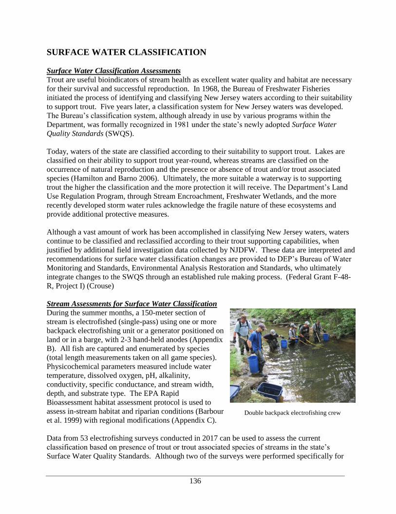
136
SURFACE WATER CLASSIFICATION
Surface Water Classification Assessments
Trout are useful bioindicators of stream health as excellent water quality and habitat are necessary
for their survival and successful reproduction. In 1968, the Bureau of Freshwater Fisheries
initiated the process of identifying and classifying New Jersey waters according to their suitability
to support trout. Five years later, a classification system for New Jersey waters was developed.
The Bureau’s classification system, although already in use by various programs within the
Department, was formally recognized in 1981 under the state’s newly adopted Surface Water
Quality Standards (SWQS).
Today, waters of the state are classified according to their suitability to support trout. Lakes are
classified on their ability to support trout year-round, whereas streams are classified on the
occurrence of natural reproduction and the presence or absence of trout and/or trout associated
species (Hamilton and Barno 2006). Ultimately, the more suitable a waterway is to supporting
trout the higher the classification and the more protection it will receive. The Department’s Land
Use Regulation Program, through Stream Encroachment, Freshwater Wetlands, and the more
recently developed storm water rules acknowledge the fragile nature of these ecosystems and
provide additional protective measures.
Although a vast amount of work has been accomplished in classifying New Jersey waters, waters
continue to be classified and reclassified according to their trout supporting capabilities, when
justified by additional field investigation data collected by NJDFW. These data are interpreted and
recommendations for surface water classification changes are provided to DEP’s Bureau of Water
Monitoring and Standards, Environmental Analysis Restoration and Standards, who ultimately
integrate changes to the SWQS through an established rule making process. (Federal Grant F-48-
R, Project I) (Crouse)
Stream Assessments for Surface Water Classification
During the summer months, a 150-meter section of
stream is electrofished (single-pass) using one or more
backpack electrofishing unit or a generator positioned on
land or in a barge, with 2-3 hand-held anodes (Appendix
B). All fish are captured and enumerated by species
(total length measurements taken on all game species).
Physicochemical parameters measured include water
temperature, dissolved oxygen, pH, alkalinity,
conductivity, specific conductance, and stream width,
depth, and substrate type. The EPA Rapid
Bioassessment habitat assessment protocol is used to
assess in-stream habitat and riparian conditions (Barbour
et al. 1999) with regional modifications (Appendix C).
Data from 53 electrofishing surveys conducted in 2017 can be used to assess the current
classification based on presence of trout or trout associated species of streams in the state’s
Surface Water Quality Standards. Although two of the surveys were performed specifically for
Double backpack electrofishing crew

137
classification purposes, the remaining 51 are valuable in confirming existing classification as well
as identifying potential upgrades.
Streams recommended for upgrades include Bear Brook (Park Ridge) (currently [FW2-NT(C1)]
by default because not previously surveyed), however data from 2017 indicates it should be
upgraded to FW2-TM(C1), with an Incidence of Occurrence value of 33.6 (Table 2). Cresskill
Brook (Demarest) is classified as FW2-NT(C1), however the Incidence of Occurrence value of
24.0 warrants an upgrade to FW2-TM(C1). Finally, YOY Brook Trout were found in two
unnamed tributaries to the Raritan River S/Br that currently have a default classification of [FW2-
NT]. Both streams were previously recommended for upgrade to FW2-TP(C1) and were
recommended to be named Raritan River S/Br (trib.)(Drakestown) and Raritan River S/Br
(trib.)(SW of Budd Lake).
Five streams currently have default classifications that were confirmed, therefore they could now
be individually listed in the Surface Water Quality Standards. St. Gabriel Brook (Saddle River)
has a default classification of [FW2-NT(C1)] and the Incidence of Occurrence value of 16.9
obtained in 2017 indicates it can now be individually listed (Table 2). Three unnamed tributaries
in the Flat Brook watershed with default classifications all resulted in finding young-of-the-year
(YOY) trout. Suggested names for these unnamed tributaries are: Big Flat Brook (trib.)(Lake
Wapalanne), Big Flat Brook (trib.)(W of Lake Ashroe), and Little Flat Brook (trib.)(Flat Brook
Office). An unnamed tributary to Rockaway Creek, S/Br currently has a default classification of
[FW2-TP(C1)] and this was confirmed by finding YOY Brown Trout. This would allow for this
unnamed tributary to be individually listed as FW2-TP(C1); if so it is recommended to name this
tributary Rockaway Creek, S/Br (trib.)(Lebanon Boro).
In addition to recommending changes to existing surface water classifications, since 2006 NJDFW
has reported surveys in which data confirm existing surface water classifications. The 2017 data
confirmed the classifications of 22 stream segments (28 surveys) and no action is required (Table
3). At times, electrofishing surveys yield data that neither confirm an existing use (classification),
nor warrant a change to the existing use (classification), as classifications are not downgraded
unless proven the existing use cannot be re-established. This was true for 15 surveys at 12
locations in 2017, therefore no action is required at this time (Tables 4).
The process of assessing the Surface Water classifications of individual waterways has resulted in
two inconsistencies of stream classification between N.J.A.C. 7:9B and the related NJDEP Surface
Water Quality GIS layer (version 201012). Oakdale Creek is currently classified as FW2-TP(C1)
within the Administrative Code, however it is labeled as “Lamington River UNT” and classified as
FW2-NT within the GIS layer. Classifications within the Administrative Code and the GIS layer
need to be reviewed to determine if additional discrepancies exist for the Clove Brook Watershed,
which originates from Lake Marcia and flows to flows to the state line. (Federal Grant F-48-R,
Project I) (Crouse)

138
Table 2. Summary of recommended surface water classification changes supported by 9 surveys conducted in 2017 by NJDFW. Reproducing trout species
determined by the presence of young-of-the-year trout. A current surface water classification enclosed by brackets indicates a default surface water classification
(i.e. the waterbody is not specifically listed in NJ’s Surface Water Quality Standards, N.J.A.C. 7:9B). I.O. = Incidence of Occurrence; NA = Not Applicable (due
to presence of trout reproduction).
Current Recommended Reproducing
Waterbody Waterbody section Midpoint of survey surface water surface water I.O. trout Survey Page
Lat. (N) Long. (W) classification classification value species date
Upper Delaware North & Wallkill Region (Shimmers Brook to Paulins Kill and Wallkill River watersheds)
*Big Flat Brook (Trib.)
(Lake Wapalanne)
Entire length, including all
tributaries 41º13’22.6” 74º45’0.9” [FW1-TP]
FW1-
TP(C1) NA Brook 7/20/17 A5
* Big Flat Brook (Trib.)
(W of Lake Ashroe)
Entire length, including all
tributaries 41º11’30.0” 74º50’6.5”
[FW2-
TP(C1)]
FW2-
TP(C1) a NA
Brook &
Brown 8/1/17 A6
* Little Flat Brook (Trib.)
(Flat Brook Office)
Entire length, including all
tributaries 41º11’43.4” 74º50’41.0”
[FW2-
TP(C1)]
FW2-
TP(C1)] NA Brook 7/13/17 A10
Lower Passaic & Upper Atlantic Region (Lower Passaic, Saddle, Hackensack, Pascack & Elizabeth to Toms River watersheds)
*Bear Brook (Park Ridge)
Spring Valley Road to
Woodcliff Lake, including
all tributaries
41º01’58.1” 74º03’34.2” [FW2-
NT(C1)]
FW2-
TM(C1) 33.6 Brown b 8/14/17 A30
Cresskill Brook (Demarest) Duck Pond Rd. bridge to
Tenakill Brook 40º55’41.0” 73º56’27.1”
FW2-
NT(C1)
FW2-
TM(C1) 24.0 None 8/8/17 A33
St. Gabriel Brook
(Saddle River)
Entire length, including all
tributaries 41º1’16.6” 74º5’55.6”
[FW2-
NT(C1)]
FW2-
NT(C1) 16.9 None 8/3/17 A35
Raritan Region (Raritan River watershed)
*Raritan River S/Br
(Trib.) (Drakestown) Entire length 40º51’9.5” 74º46’01.4” [FW2-NT]
FW2-
TP(C1) a NA Brook 8/29/17 A51
*Raritan River S/Br (Trib.)
(SW of Budd Lake) Entire length 40º51’25.0” 74º46’00.1” [FW2-NT]
FW2-
TP(C1) a NA Brook 8/29/17 A54
*Rockaway Creek, S/Br
(Trib.) (Lebanon Boro)
Headwaters to confluence
with Rockaway Creek, S/Br,
including all tributaries
40º38’31.7” 74º49’39.9” [FW2-
TP(C1)]
FW2-
TP(C1) NA
Brown &
Rainbow c 8/29/17 A58
a Potential change also supported by data collected previously b Young-of-the-year trout not present, however trout from older year classes present. c Stocked trout
* Indicates unnamed tributary as recognized by SWQS. Name given is recommended by NJDFW.

139
Table 3. Electrofishing surveys conducted in 2017 by NJ Division of Fish and Wildlife that confirm existing surface water classifications as indicted in New
Jersey’s Surface Water Quality Standards, N.J.A.C. 7:9B. No action is required. Reproducing trout species is determined by the presence of young-of-the-year
trout. Data are found in report titled “2017 Investigation and Management of NJ’s Freshwater Fisheries Resources.”
Waterbody Waterbody section
Midpoint of survey Current
surface water
classification
confirmed
I.O.
value
Reproducing
Trout
Species
Date Page Lat. (N) Long. (W)
Upper Delaware North & Wallkill Region (Shimmers Brook to Paulins Kill and Wallkill River watersheds)
Beerskill Creek
(Shaytown)
Boundary of High Point State Park
to confluence with Little Flat Brook 41º15’34.9” 74º47’34.6” FW2-TP(C1) NA Brook 8/8/17 A1
Upper Delaware (South) Region (Delawanna Creek to Lockatong Creek watersheds)
Pequest River (Vienna) Tranquility bridge to Lehigh and
HudsonRiver railway bridge 40º53’17.9” 74º54’12.7” FW2-NT 9.9 None 8/17/17 A18
Pequest River (Vienna) Tranquility bridge to Lehigh and
HudsonRiver railway bridge 40º52’47.3” 74º54’20.7” FW2-NT 9.1 None 8/17/17 A19
Stephensburg Brook
(Stephensburg) Entire length 40º47’34.7” 74º52’16.6” FW2-TP(C1) NA
Brook &
Brown 8/14/17 A20
West Portal Creek
(West Portal) Entire length 40º39’46.6” 75º02’0.1” FW2-TP(C1) NA
Brook &
Brown 7/20/17 A21
West Portal Creek
(West Portal) Entire length 40º40’52.7” 75º01’49.1” FW2-TP(C1) NA Brown 7/20/17 A22
Upper Passaic Region (Pompton, Pequannock, Wanaque, Ramapo, Upper Passaic, Whippany, & Rockaway River watersheds)
Pequannock River
(Kinnelon)
Macopin Reservoir outlet to
Hamburg Turnpike bridge in
Pompton Lakes Borough
41º00’14.7” 74º20’58.0” FW2-TP(C1) NA Brown &
Rainbow c 7/11/17 A23
Pequannock River
(Kinnelon)
Macopin Reservoir outlet to
Hamburg Turnpike bridge in
Pompton Lakes Borough
41º00’7.8” 74º18’59.4” FW2-TP(C1) NA Brown &
Rainbow b 7/11/17 A24
Pequannock River
(Kinnelon)
Macopin Reservoir outlet to
Hamburg Turnpike bridge in
Pompton Lakes Borough
40º59’57.4” 74º18’19.7” FW2-TP(C1) NA Brown &
Rainbow b 7/10/17 A25
Pequannock River
(Kinnelon)
Macopin Reservoir outlet to
Hamburg Turnpike bridge in
Pompton Lakes Borough
40º59’58.2” 74º17’53.1” FW2-TP(C1) NA Brown &
Rainbow b 7/10/17 A26
Raritan Region (Raritan River watershed)
Beaver Brook
(Annandale)
Beaver Ave. bridge downstream to
the lower most I-78 bridge 40º38’18.9” 74º52’49.9” FW2-TP(C1) NA
Brown &
Rainbow b 8/16/17 A36
Beaver Brook (Clinton)
Lower most I-78 bridge
downstream to, the South Branch
Raritan River
40º38’13.9” 74º54’23.9” FW2-TM 29.1 Brown a 8/16/17 A37

140
Table 3 (continued) Raritan Region (Raritan River watershed) (continued)
Electric Brook
(Schooley’s Mtn) Entire length 40º47’19.0” 74º46’39.9” FW2-TP(C1) NA Brown 7/19/17 A40
Hickory Run (Califon) Entire length 40º42’55.8” 74º51’45.5” FW2-TP(C1) NA Brook 8/11/17 A41
Oakdale Creek (Chester) Entire length 40º47’52.1” 74º41’55.1” FW2-TP(C1) NA Brook 7/26/17 A49
Raritan River S/Br
(Trib.)
(S. of Hoffmans)
Entire length 40º41’47.2” 74º52’13.1” FW2-TP(C1) NA Brown 7/19/17 A52
Raritan River S/Br
(Trib.) (S. of
Schooleys Mtn.)
Entire length 40º46’25.8” 74º48’22.8” FW2-TP(C1) NA
Brook &
Brown 7/31/17 A53
Rinehart Brook
(Hacklebarney) Entire length 40º44’40.0” 74º44’10.0” FW2-TP(C1) NA
Brook &
Brown 8/23/17 A55
Rockaway Creek, S/Br
(Clinton)
Headwaters to Readington
Township boundary including all
tributaries
40º38’23.8” 74º49’22.8” FW2-TP(C1) NA Brown 8/29/17 A57
Rocky Run
(Lebanon) Entire length 40º41’41.0” 74º54’36.9” FW2-TP(C1) NA Brook 8/11/17 A59
Spruce Run
(Glen Gardner)
Source to, but not including,
Spruce Run Reservoir 40º41’26.1” 74º56’9.3” FW2-TP(C1) NA
Brook &
Brown 8/1/17 A60
Spruce Run
(Glen Gardner)
Source to, but not including,
Spruce Run Reservoir 40º40’53.0” 74º55’25.8” FW2-TP(C1) NA
Brook &
Brown 8/1/17 A61
Stony Brook
(Washington) Entire length 40º47’49.6” 74º45’17.3” FW2-TP(C1) NA
Brook &
Brown 8/21/17 A62
Teetertown Brook
(Lebanon) Entire length 40º45’0.4” 74º50’43.1” FW2-TP(C1) NA Brook 7/31/17 A64
Trout Brook
(Hacklebarney) Entire length 40º45’05.0” 74º43’52.5” FW2-TP(C1) NA Brook 8/23/17 A65
Turkey Brook
(Mt. Olive) Entire length 40º50’18.7” 74º44’29.7” FW2-TP(C1) NA
Brook &
Brown 8/14/17 A66
Willhoughby Brook
(Buffalo Hollow) Entire length 40º40’18.5” 74º54’49.5” FW2-TP(C1) NA
Brook a &
Brown 8/10/17 A67
Lower Delaware Region (Assunpink Creek to Maurice River watersheds)
Scotland Run Maurice River Main Stem
(Willow's Grove) 39º39’17.8” 75º03’5.5” FW2-NT 4.8 none 7/13/17 A68
a Young-of-the-year trout not present, however trout from older year classes present. b Stocked trout

141
Table 4. Electrofishing surveys conducted in 2017 by NJ Division of Fish and Wildlife that neither confirm an existing use (classification), nor warrant a change to
the existing use, as classifications are not downgraded unless proven the existing use cannot be re-established. Reproducing trout species is determined by the
presence of young-of-the-year trout. Data are found in report titled “2017 Investigation and Management of NJ’s Freshwater Fisheries Resources.”
Waterbody Waterbody section Midpoint of survey Current
surface water
classification
I.O.
value
Reproducing
Trout
Species
Date Page Lat. (N) Long. (W)
Upper Delaware (North) & Wallkill Region (Shimmers Brook to Paulins Kill and Wallkill River watersheds)
Big Flat Brook
(Sandyston)
Confluence with Parker Brook, through
the Blewitt Tract, to the confluence
with Flat Brook, except tributaries
described under the listing for Flat
Brook
41º11’54.9” 74º49’5.1” FW2-TP(C1) 31.9 Rainbow b 8/15/17 A2
Big Flat Brook
(Sandyston)
Confluence with Parker Brook, through
the Blewitt Tract, to the confluence
with Flat Brook, except tributaries
described under the listing for Flat
Brook
41º12’23.5” 74º48’22.3” FW2-TP(C1) 27.7 Rainbow b 8/15/17 A4
Big Flat Brook
(Sandyston)
Confluence with Parker Brook, through
the Blewitt Tract, to the confluence
with Flat Brook, except tributaries
described under the listing for Flat
Brook
41º11’30.6” 74º50’34.6” FW2-TP(C1) 19.8 none 8/1/17 A4
c Flat Brook
(Walpack)
Flatbook-Roy Wildlife Management
Area boundary to the Delaware River,
except segments described below
41º11’05.9” 74º51’09.1” FW2-TM(C1) NA Brown 8/9/17 A7
Forked Brook
(Stokes State Forest) Entire length 41º14’20.9” 74º44’42.3” FW2-TP(C1) 53.4 Brook a 8/8/17 A8
Little Flat Brook
(Layton)
State park boundary to, but not
including, tributary described below, to
confluence with Big Flat Brook
41º17’5.7” 74º45’25.2” FW1-TP 32.1 none 7/20/17 A9
Sparta Glen Brook
(Sparta) Entire length 41º2’19.0” 74º36’57.2” FW2-TP(C1) 36.1 Brook a 7/12/17 A11
Sparta Glen Brook
(Sparta) Entire length 41º2’18.1” 74º36’42.0” FW2-TP(C1) 36.1 Brook a 7/12/17 A12

142
Table 4. (continued)
Lower Passaic & Upper Atlantic Region (Lower Passaic, Saddle, Hackensack, Pascack & Elizabeth to Toms River watersheds)
Cresskill Brook
(Alpine)
Source to Duck Pond Rd. bridge,
Demarest 40º56’26.9” 73º56’1.6” FW2-TP(C1) 32.1 none 8/21/17 A31
Cresskill Brook
(Alpine)
Source to Duck Pond Rd. bridge,
Demarest 40º56’41.0” 73º56’27.1” FW2-TP(C1) 16.0 none 8/8/17 A32
Raritan Region (Raritan River watershed)
Black Brook (Polktown) Entire length 40º39’39.0” 74º56’54.6” FW2-TP(C1) 35.7 Brown a 8/10/17 A38
Drakes Brook (Trib)
(Mt. Olive)
Source downstream to Central Railroad
bridge 40º49’54.8” 74º42’59.8” FW2-TP(C1) 14.2 none 7/26/17 A39
Lamington (Black) River
(Trib)(Ironia)
Source downstream to, but not
including, Bryant Pond 40º49’58.9” 74º37’25.6” FW2-TP(C1) 0 none 7/26/17 A42
Mine Brook (Trib)
(E of Mine Mt.) Entire length 40º42’56.0” 74º35’42.6” FW2-TP(C1) 30.9 Brook a 7/27/17 A47
Mine Brook (Trib)
(S of Mine Mt.)
Source downstream to Douglass Road
Bridge 40º42’7.9” 74º36’30.6” FW2-TP(C1) 17.1 none 7/27/17 A48
Sun Valley Brook
(Mt. Olive) Entire length 40º51’1.8” 74º45’24.0” FW2-TP(C1) 26.6 none 8/21/17 A63
a Young-of-the-year trout not present, however trout from older year classes present. b Stocked trout c Only one young-of-the-year present during 2017 survey. No YOY found during numerous surveys in recent history. More data needed prior to
recommending upgrade.

143
Lake Assessments for Surface Water Classification
As part of the continued assessment of New Jersey waters dissolved oxygen and temperature
profiles are performed to determine a lake’s ability to support trout throughout the harsh summer
months. During the summer, most New Jersey lakes deeper than 3 m (10 ft) thermally stratify.
The epilimnion (surface waters) become too warm to support coldwater fishes (trout), and the
metalimnion and hypolimnion (middle and bottom waters), while often cold enough for trout,
often have dissolved oxygen levels too low to support trout (and other fish species). Only deep
lakes (generally at least 15 m (50 ft) deep), that are not overly eutrophic, maintain sufficient
levels of dissolved oxygen in some portion of the strata below the epilimnion during the summer
and early fall. A water temperature and dissolved oxygen profile is conducted in the deepest part
of a lake using a YSI meter with cable marked in one-foot increments. Measurements are
generally taken at 5 to 10-ft intervals, but more frequently (1-ft increments) when marked
changes are observed (typically in the metalimnion). A secchi disk (also marked in one-foot
increments) is used to measure water transparency. The criteria used to determine trout-
supporting water is water temperature < 21ºC (69.8ºF) and dissolved oxygen > 4 mg/L
(Appendix B). If criteria are met, Lakes and reservoirs are classified as Trout Maintenance and
they are classified as Non-Trout if they are not met. The presence and amount of trout
supporting water can vary from year to year, depending on air temperature and rainfall. Shallow
lakes, particularly those less than 50 feet deep, often have little or no trout supporting water
during the summer due to anoxic conditions in their colder bottom waters and warm surface
waters. (Federal Grant F-48-R, Project I) (Crouse)
One water temperature and dissolved oxygen profile was conducted in 2017. It was conducted
during the summer months and can be used to use for classification purposes in the Surface
Water Quality Standards (Table 6). This survey confirmed the existing classification, therefore
no additional surveys are necessary for classification purposes at this time.
Egg Harbor Township Nature Reserve Lake (Atlantic) – Egg Harbor Township Nature Reserve
Lake is a 29-acre waterbody located within Egg Harbor Township. The lake is located within
the 220-acre Egg Harbor Township Nature Reserve and is an old sand quarry. A dissolved
oxygen temperature profile was completed on August 2, 2017. The deepest recorded depth was
19 feet and suitable dissolved oxygen levels to support aquatic life were found down to 13 feet
within the lake, however no trout supporting water (see below). Water chemistry was recorded;
conductivity measured 51.8 us/cm, salinity 0.02 ppt, and pH 8.64. (Boehm)
Table 6. Summary of temperature and dissolved oxygen profile conducted during the summer months on one
lakes in 2017. Results page number references in 2017 Investigations and Management of NJ’s Freshwater
Fisheries Resources Report.
Waterbody (County)
Current
surface water
classification
Depth (ft) of water
capable of
supporting trout a
Recommended
classification change Date Page
Lower Atlantic Coastal (Sloop Creek to Dennis Creek watersheds)
Egg Harbor Township
Reserve Pond FW2-NT(C1) none confirmed 8/2/17 71 & 89
a Depth measured from the surface; criteria for trout supporting water: water temperature < 21ºC and dissolved
oxygen > 4 mg/L
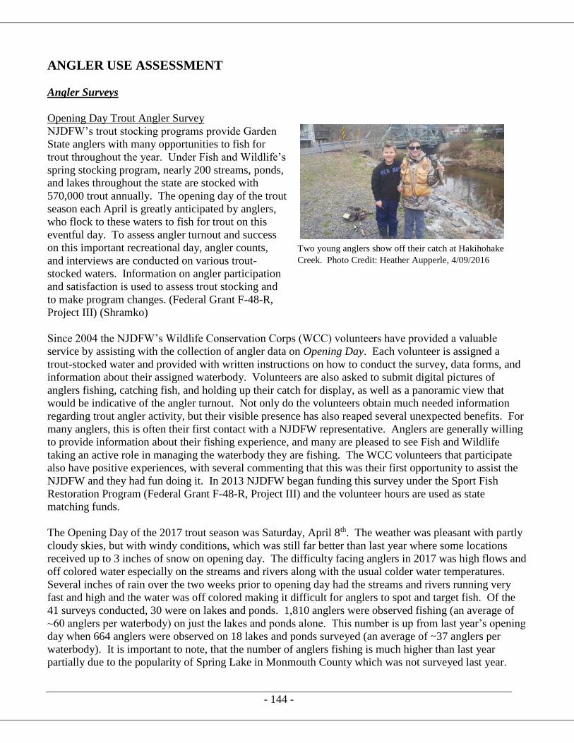
- 144 -
ANGLER USE ASSESSMENT
Angler Surveys
Opening Day Trout Angler Survey
NJDFW’s trout stocking programs provide Garden
State anglers with many opportunities to fish for
trout throughout the year. Under Fish and Wildlife’s
spring stocking program, nearly 200 streams, ponds,
and lakes throughout the state are stocked with
570,000 trout annually. The opening day of the trout
season each April is greatly anticipated by anglers,
who flock to these waters to fish for trout on this
eventful day. To assess angler turnout and success
on this important recreational day, angler counts,
and interviews are conducted on various trout-
stocked waters. Information on angler participation
and satisfaction is used to assess trout stocking and
to make program changes. (Federal Grant F-48-R,
Project III) (Shramko)
Since 2004 the NJDFW’s Wildlife Conservation Corps (WCC) volunteers have provided a valuable
service by assisting with the collection of angler data on Opening Day. Each volunteer is assigned a
trout-stocked water and provided with written instructions on how to conduct the survey, data forms, and
information about their assigned waterbody. Volunteers are also asked to submit digital pictures of
anglers fishing, catching fish, and holding up their catch for display, as well as a panoramic view that
would be indicative of the angler turnout. Not only do the volunteers obtain much needed information
regarding trout angler activity, but their visible presence has also reaped several unexpected benefits. For
many anglers, this is often their first contact with a NJDFW representative. Anglers are generally willing
to provide information about their fishing experience, and many are pleased to see Fish and Wildlife
taking an active role in managing the waterbody they are fishing. The WCC volunteers that participate
also have positive experiences, with several commenting that this was their first opportunity to assist the
NJDFW and they had fun doing it. In 2013 NJDFW began funding this survey under the Sport Fish
Restoration Program (Federal Grant F-48-R, Project III) and the volunteer hours are used as state
matching funds.
The Opening Day of the 2017 trout season was Saturday, April 8th. The weather was pleasant with partly
cloudy skies, but with windy conditions, which was still far better than last year where some locations
received up to 3 inches of snow on opening day. The difficulty facing anglers in 2017 was high flows and
off colored water especially on the streams and rivers along with the usual colder water temperatures.
Several inches of rain over the two weeks prior to opening day had the streams and rivers running very
fast and high and the water was off colored making it difficult for anglers to spot and target fish. Of the
41 surveys conducted, 30 were on lakes and ponds. 1,810 anglers were observed fishing (an average of
~60 anglers per waterbody) on just the lakes and ponds alone. This number is up from last year’s opening
day when 664 anglers were observed on 18 lakes and ponds surveyed (an average of ~37 anglers per
waterbody). It is important to note, that the number of anglers fishing is much higher than last year
partially due to the popularity of Spring Lake in Monmouth County which was not surveyed last year.
Two young anglers show off their catch at Hakihohake
Creek. Photo Credit: Heather Aupperle, 4/09/2016

- 145 -
Spring Lake has a very popular kid’s fishing derby on opening day annually. This year about 666 anglers,
many of them children, were fishing Spring Lake. If we remove the Spring Lake anglers from the
calculation, survey clerks recorded 1,144 anglers on 29 waterbodies statewide (an average of ~39 anglers
per waterbody). This is slightly better than the 37 anglers per waterbody recorded on 18 lakes and ponds
last year.
Trout-stocked Lakes and Ponds Results
In some locations trout fishing was fantastic. Several anglers expressed what a wonderful day of fishing
they had and thanked the Division of Fish and Wildlife for their efforts in making the 2017 opening day a
huge success. Mountain Farm Pond (Hunterdon), Silver Lake (Sussex) and South Vineland Park Pond
(Cumberland), to name a few, were by far the place to be on opening day as anglers had the highest catch
rates per angler at 2.10 fish per angler, 1.30 and 0.94 fish per angler respectively.
Unfortunately, trout were not as cooperative in all the lakes and ponds across the state. The higher than
usual, murky and cold water temperatures (mid-30’s to mid-40’s) appeared to keep the fish from biting,
frustrating anglers and sending them home early in multiple locations. Many clerks reported the number
of anglers at a waterbody was highest at 8 a.m. or sometimes 9 a.m. but dropped heavily by 10 a.m. and
throughout the rest of the day.
The following waterbodies had a total of five or fewer trout reportedly caught by all anglers. The number
of anglers ranged from 87 to 26.
▪ Burnham Park Pond – 87 anglers caught 1 trout
▪ Birch Grove Park Ponds – 85 anglers caught 2 trout
▪ Rosedale Lake – 44 anglers caught 2 trout
▪ Laurel Pond – 39 anglers caught 5 trout
▪ Mt. Hope Pond – 31 anglers caught 0 trout
▪ Tuckahoe Lake – 29 anglers caught 3 trout
▪ Colonial Lake – 26 anglers caught 0 trout
The following waterbodies also reportedly caught five trout or less, but had considerable fewer anglers (7-
16 anglers total):
▪ Swedesboro Lake – 16 anglers caught 1 trout
▪ Lake Shenandoah – 15 anglers caught 0 trout
▪ Columbia Lake – 14 anglers caught 1 trout
▪ Lake Musconetcong – 13 anglers caught 0 trout
▪ Mill Pond – 9 anglers caught 2 trout
▪ Mountain Lake – 7 anglers caught 0 trout

- 146 -
Angler success rate data has been collected and
calculated per waterbody starting in 2008. Since then,
the Division has had the ability to compare one year’s
opening day’s success to another year’s opening day
success. 2017 results showed the worst anglers success
rates compared with previous opening days. 2017 had a
success rate per angler of 0.22 fish per angler or just over
1 fish for every 5 anglers. The poor success in 2017 can
be attributed to higher water flows, off colored water, and
cold water temperatures. The most successful opening
day was in 2008 when 0.73 trout were caught per angler.
See table below for more detail.
Yearly comparison of angler success rate
2008 2009 2010 2011 2012 2013 2014 2015 2016 2017 AVERAGE
Anglers 1115 853 1095 1462 1675 1918 1830 2100 664 1810 1452
# Trout 814 485 551 669 1107 1354 996 960 380 402 772
Trout/Angler 0.73 0.57 0.50 0.46 0.66 0.71 0.54 0.46 0.57 0.22 0.53
Total
Some waterbodies have been producing consistently bad opening day success rates. The following
waterbodies in Table below will continue to be monitored, but if their success does not change, they could
be dropped from the trout stocking program in the future.
A complete list of the 2017 Opening Day angler success on the lakes and ponds can be found in the
appendix of this report along with information on angler success.
Waterbodies with consistent poor angler success.
County Waterbody Acres 2010 2011 2012 2013 2014 2015 2016 2017 AVERAGE
Anglers 58 50 22 28 50 26 39
# Trout 4 8 0 2 0 0 2
Trout/Angler 0.07 0.16 0 0.07 0 0 0.06
Anglers 14 25 7 21 23
# Trout 1 3 0 2 3
Trout/Angler 0.07 0.12 0 0.1 0.13
Mercer Colonial Lake 10
AtlanticHeritage
Park Pond6
Jonathan Paterno holds one of the coveted
broodstock from South Vineland Park Pond.

147
Trout-stocked Streams and Rivers
Typically, Opening Day Trout Angler Survey
may only have a few streams or rivers as part
of the survey because angler counts and
success on streams and rivers is difficult to
assess. The distance that has to be covered
and the movement in and out of fishing spots
by anglers makes it difficult to get accurate
quantitative data from the survey.
Angler surveys and counts were conducted on
11 streams or small sections of streams in
2017. A total of 161 anglers were surveyed.
The catch rate was very inconsistent. The
larger rivers had very high flows and the water
was off colored making it very difficult for
anglers to target and catch trout. Despite the
difficult conditions, a few anglers found some success at the Musconetcong River, the Pohatcong
Creek and the Pequannock River with catch rates nearing 1 fish per angler. Anglers struggled a
little bit more than average on the Pequest and the Paulinskill in the small sections that were
surveyed.
The smaller streams had better conditions, but the catch was still inconsistent. Some smaller
streams like the Hakihokake Creek and India Brook anglers did well, while others like
Lopatcong Creek, and Pophandusing Creek had few anglers and no fish were caught from 8:00
until the time they were surveyed.
In summary, opening day on the streams and rivers was hit or miss with difficult fishing
conditions especially on the bigger rivers. A few anglers did well even under the difficult
conditions, but overall fishing streams and rivers was slow and difficult.
A complete list of Opening Day angler counts on streams and rivers can be found in appendix of
this report along with information on angler success.
In Summary
Opening Day success in 2017 was varied. The cold water temperatures and high stream flows in
areas definitely had a negative effect on the number of anglers and the success rate at many
waterbodies. However, some waterbodies still showed a strong angler contingent, and many
waterbodies produced a much higher than average angler success rate. Surprisingly, some
anglers fishing streams, even with the higher than average flows, were still quite successful, but
unfortunately the average angler’s success rate was far lower than past opening days. The
average angler’s catch rate was 0.22 fish per angler on ponds and lakes. This is much lower than
the average angler success rate of 0.53 fish per angler fishing ponds and lakes.
The overall number of opening day anglers counted in this year’s survey was 1,810 anglers. This
number is higher than the average number of anglers since 2008, but was highly influenced by
Angler William Gunderman proudly holds his first
trout of the season, caught at Franklin Pond Creek.
Photo Credit: Lisa Kisch, 04/09/2016

148
Spring Lake in Monmouth County which had over 600 anglers. The sunny and 50ᵒF forecasted
temperatures definitely had people out fishing, but the colder water temperatures and higher
flows kept many fish from biting. Spring Lake had the largest showing of anglers with 666
individuals fishing. But the place to be was Mountain Farm Pond in Hunterdon County as 82
trout were caught by 39 anglers (2.10 fish per angler). Not bad for the first 4 hours of the season.
Despite the overall average to slow start to the spring trout fishing season on many waterbodies,
anglers will be more successful as the season progresses, when warmer waters, lower flows, and
milder days prevail.
Reports and detailed results noted by volunteer survey clerks for each waterbody surveyed can
be found in the appendix of this report.
Acknowledgements
New Jersey Division of Fish and Wildlife’s Bureau of Freshwater Fisheries staff would like to
thank the following Volunteers and DEP staff who make this project possible every year.
Together with NJDFW staff angler counts were conducted on 40 waterbodies across the state. A
special note of thanks is also extended to Fisheries Technician Chuck Sedor for coordinating the
volunteer efforts.
Survey Clerks
Name Affiliation Name Affiliation
Aysia Gandy WCC Betsy Isley WCC Justin Fuller WCC John Miraglia WCC
Amy Loesser WCC Matt Mattei WCC
Cathy Beil WCC Rob Sexton WCC
Hung Le WCC Patience Armstrong WCC
Ed Ward WCC James Becker WCC
Jim Velcheck WCC Sami Doganay WCC
Joe DeFelice WCC Amanda Van Buskirk WCC
Dave Bright WCC Travis Prefach WCC
Donna Herrmann WCC Kathy Collins WCC
Tito Ramirez WCC Patricia Walker WCC
Daniel Simmler WCC Randall Fiore WCC
Fred Klein WCC Bill Praschil WCC
Lauren Rojewski WCC Domenic Lanciano WCC
Reports and detailed results noted by volunteer survey clerks for each waterbody surveyed can
be found in Appendix F of this report. (Federal F-48-R, Project III) (Shramko)

149
Trout Angler Logbook Program
NJDFW utilizes a logbook (diary) program to obtain current information regarding trout angler
catch and effort on special regulation areas on trout streams. Initially launched as a pilot
program in 2012 on three special regulation trout fishing areas, the program was expanded in
2013 to include all seven areas. Logbooks are distributed annually to experienced anglers who
indicate they regularly fish one or more of the areas in the study. Anglers record information
about fish harvested or released during each trip, as well as time spent fishing and gear used. At
the end of the calendar year anglers return their logbooks to NJDFW and the data is then
compiled and analyzed during the following calendar year. Compared to other survey methods,
angler logbooks are one of the least expensive ways to collect information on a fishery. Data
collected through angler logbooks supplement other data collected by NJDFW (such as Opening
Day angler surveys, telephone and internet-based surveys, on-site angler creel surveys, fish
population surveys using electrofishing gear, and water temperature monitoring). Collectively,
this data aids in evaluating the fishery and guides managers and stakeholders in making informed
decisions that benefit both resource users and the resource. (Federal Grant F-48-R, Project III)
In 2016 seven special regulation areas were included in the logbook program and the logbooks
results were compiled (see table below). A total of 78 anglers were issued logbooks for the
program, receiving a total of 84 logbooks (some anglers needed more than one logbook to record
all their trips). Despite efforts to encourage logbook returns, only 13 anglers (16%) returned
their logbooks, down from a 19% return rate in 2015. Collectively, the 13 logbook anglers
logged 194 trips to 5 of the 7 special regulation trout fishing areas and spent a total of 958.5
hours fishing these areas. The Big Flat Brook / Flat Brook Catch and Release (C&R) area was
the most commonly visited site with 74 trips (38%), followed by the Musconetcong River YTCA
(70 trips, 36%), and the Ken Lockwood Gorge C&R section of the South Branch Raritan River
(34 trips, 18%). The remaining 14 trips (8% of total) were to the Pequest River STCA (11 trips,
6%) and the S/Br. Raritan River – Claremont Stretch YTCA (3 trips, 2%). No fishing trips were
recorded for the Toms River YTCA or the Pequannock River TCA. Anglers fished an average of
1.4 to 4.6 hours per trip; the highest average trip lengths were on the Ken Lockwood Gorge (4.6
hrs/trip), the Musconetcong River (4.5 hrs/trip), and Pequest (2.9 hrs/trip). The logbook data
includes trips that were taken to the STCAs at times when the special regulations were not in
effect. Fly fishing gear was used by anglers for most trips; only 3 trips (2%) by one angler used
both spin and fly fishing gear.
Logbook anglers recorded a total catch of 1,118 trout. Catch and release fishing was practiced
by all participants in the study; no fish were recorded as kept (or unrecorded). Angler catch rate
averaged 1.2 trout/hr, down from 2.0 in last year’s survey. Catch per hour ranged (by special
regulation area) from 0.7 – 1.6 trout/hour. The average number of trout caught per trip was 4.5,
and by special regulation area ranged from 1.4 – 7.2 trout/trip. These catch rates are noticeably
lower than previous year’s logbook reports (2013 – avg. 7.0/trip, 1.8/hr., 2014 – avg. 5.2/trip,
1.9/hr., 2015 – avg. 8.0/trip, 2.0/hr.). While it is difficult to say why with certainty, participating
anglers frequently mentioned very low water levels in their fishing notes, which may have led to
reduced fishing success. The highest catch rates (per hour and per trip) occurred in the
Musconetcong River Point Mountain YTCA (1.6/hr, 7.2/trip). The lowest catch rate was on the
Claremont YTCA on the South Branch of the Raritan River (0.7 trout/hr and 1.4 trout/trip). Most
trip reports were close to the average, though ten trips were recorded with more than 20 fish
caught, with the highest being 35 fish in one trip to the Flat Brook.

150
Of the total trout caught, anglers recorded the species for all but two fish. Overall Rainbow
Trout were caught most frequently (96%), followed by Brown Trout (1.6%), and Brook Trout
(1.4%). Two Tiger trout (Brook X Brown hybrid) were recorded in the Ken Lockwood Gorge (9
and 10 inches in length).
Anglers were also asked to note if the origin of each trout they caught was wild, stocked, or
unknown. This assessment can be very subjective and difficult since a decision is based
primarily upon fin wear and fish coloration. Anglers reported catching 35 (3%) wild trout and
1,066 (96%) stocked trout. 17 (1%) trout were recorded as species origin unknown, indicating
that most anglers were confident in their ability to distinguish wild from stocked fish. This may
be in part due to the state’s exclusive stocking of Rainbow trout; anglers feel confident that any
Brook or Brown trout they catch are either wild in origin or stocked privately. Wild Rainbow
trout are relatively uncommon in New Jersey.
The average size of trout caught (results not provided in the table) was 284 mm (11.2 in.) and
they ranged in size from 101 mm (4 in.) (Brook trout, Musconetcong River) to 685 mm (27 in.)
(Rainbow trout, Pequest River STCA). Fifty-four % (606) of trout recorded fell within 9 to 11
inches, typically stocked by the Pequest Trout Hatchery. Eighty % (896) were between 8 and 12
inches, a range which allows for some variation in length estimates (anglers are asked only to
estimate trout length, not required to carry a measuring device) and slight differences in stocking
length.
Summary of fishing trip and catch statistics for 19 logbooks returned by 13 anglers.
participated in the 2016 Trout Angler Logbook Program which targeted 7 special regulation
trout fishing areas. Total Hours Number of trout Total Number of trout Number of
trout number Per caught by species1 trout caught by origin %
wild caught per
of trips Trip BKT BNT RBT UNK caught Wild Stocked UNK1 caught Hour Trip
Big Flat Brook / Flat Brook (Catch & Release Area)
76 2.9 3 1 360 0 360 4 359 1 1% 1.6 4.8
Musconetcong River – Point Mtn. (Year-Round Trout Conservation Area)
70 4.6 11 5 484 2 502 28 465 9 5% 1.6 7.2
S/Br. Raritan River – Ken Lockwood Gorge (Catch & Release Area)
34 4.5 0 12 211 2* 225 2 216 7 4% 1.5 6.5
Pequest River (Seasonal Trout Conservation Area)
11 3.3 0 0 28 0 28 0 28 0 0% 0.8 2.5
S/Br. Raritan River – Claremont Stretch (Year-Round Trout Conservation Area)
3 1.4 1 0 2 0 3 1 2 0 33% 0.7 1.4
Pequannock River (Seasonal Trout Conservation Area)
- - - - - - - - - - - - -
Toms River (Year-Round Trout Conservation Area)
- - - - - - - - - - - - -
1 BKT = Brook Trout; BNT = Brown Trout; RBT = Rainbow Trout; UNK = unknown (trout species or origin).
* = One angler reported two Tiger Trout, Brook X Brown Trout hybrids. These trout included in UNK Count.
In 2017, 88 logbooks were prepared and distributed to anglers who indicated they regularly fish
the seven stream sections described above. The data from these logbooks will be compiled and
the results summarized in the 2018 Investigations and Management of New Jersey’s Freshwater
Fisheries Resources report.

151
INFORMATION AND EDUCATION
In addition to a multitude of research and management activities, the Bureau of Freshwater
Fisheries actively participates in a number of Information and Education activities each year.
Several such as two annual Fisheries Forums, a Public Trout Meeting, and biennial Public
Hearing are directly tied to research and management activities and promulgation of regulations
governing the state’s freshwater aquatic resources. In addition, Bureau staff actively participates
in the preparation of the Freshwater Fishing Digest. For the 2017 edition, the first of two feature
articles is titled, “Giving Wild Trout a Helping Hand” and explains new regulations geared
towards protecting wild trout populations. The second feature article is titled “Managing
Monster Muskies,” which describes sampling efforts and the results that lead towards new
regulations to manage for bigger Muskies. The Freshwater issue of the Digest is perhaps the
most widely distributed publication throughout the Department.
Division of Fish and Wildlife Mobile Trailer
Bureau staff participated on the planning team for the Mobile Conservation Outreach Trailer
Project (MCOT). The 27-ft trailer will contain interactive exhibits that inform the public about
NJDFW's fish and wildlife management activities and conservation successes resulting from the
partnership with the Wildlife and Sportfish Restoration Program (WSFR). The purpose is to
increase public knowledge of NJDFW and its mission, as well as to highlight how WSFR helps
to meet agency goals. Assistance was provided in developing story lines related to freshwater
fisheries research and management activities (fish sampling and fish culture) and to explain how
scientific data collected by the Bureau was used to develop a statewide stream classification
system to protect surface waters). Staff also provided photos and artifacts to be used in displays.
(Hamilton)
Professional Meetings/Conferences
New Jersey participates in a number of regional initiatives geared towards the protection of the
nation’s freshwater fisheries resources. As such, state fisheries biologists participate in a number
of regional panels and workshops to share information and experiences with biologists in other
states on a variety of topics in the realm of fisheries management.
Merrill Creek Reservoir - The annual fisheries management meeting with staff that manages
Merrill Creek Reservoir, their consultant, and NJDFW staff was held on March 3, 2017 to review
and discuss the fisheries data collected in 2016 and future management of the recreational
fisheries. The data collected on Lake Trout continues to indicate this species is reproducing
successfully in the reservoir (stocking was discontinued in 2013). The potential introduction of
another salmonid species (Landlocked Salmon) was discussed and favorably received.
(Hamilton)

152
Public Presentations
Each year state fisheries biologists attend meetings of a variety of organizations which may
include angling clubs, watershed groups, local planning boards, and sportsmen shows. (Hunter
and Angler Fund)
In 2017, presentations on the fisheries resources within the state were presented to:
North Jersey Freshwater Fisheries Forum – Thirty-seven anglers attended the annual North
Jersey Freshwater Fisheries Forum held on January 21, 2017. The purpose of the forum is to
disseminate information pertaining to Bureau research and management activities and provide
attendees the opportunity to comment on our fisheries programs and interact with Bureau staff.
Presentations included results from the three-year Coolwater Fisheries Assessment of Walleye,
Musky, Northern Pike, and Hybrid Striped by Fisheries Biologist Scott Collenburg and a review
of warmwater fish production by Tyler Tresslar. All Bureau of Freshwater Fisheries staff
attended the meeting and answered questions from anglers.
Outdoor Writer’s Workshop – Fisheries Biologist Scott Collenburg prepared and presented a
PowerPoint presentation on the Coolwater Fisheries Assessment and various Bureau of
Freshwater Fisheries activities, including highlights from the Bureau’s 2016 Field Sampling
Season.
Round Valley Trout Association – Biologist Shawn Crouse prepared and presented a PowerPoint
presentation at Round Valley Trout Association’s meeting held on March 23, 2017. Information
provided included important dates, upcoming NJDFW events, current research and management
of Round Valley Reservoir, with a focus on the Lake Inventory and Management Plan.
South Jersey Freshwater Fisheries Forum – Thirty-five anglers attended the annual South Jersey
Fisheries Forum held on February 25, 2017 at the Batsto Visitor’s Center. Principal Biologist,
Christopher Smith presented highlights of warmwater lake electrofishing surveys and Fisheries
Biologist, Scott Collenburg presented results of the Coolwater Fisheries Assessment. A question
and answer period and open discussion followed the presentations.
Trout Meeting – Ninety-seven anglers attended the annual Trout Meeting held on February 25,
2017 at the Pequest Trout Hatchery. Ed Conley, Fish Production Chief, presented hatchery
production numbers for the upcoming spring trout stocking. Senior Fisheries Biologist, Ross
Shramko, presented information on allocation and waterbody changes for the spring stocking as
well as presented potential Wild Trout Regulations. An extensive question and answer period,
and open discussion followed the presentations.
Wild Trout Stream Regulation - During the spring, staff biologists attended meetings of 10 Trout
Unlimited chapters to present recommendations and solicit angler feedback regarding potential
changes to the Wild Trout Stream regulations and the establishment of a Brook Trout
Conservation Zone.

153
Public Events
The New Jersey WILD Outdoor Expo is an annual event celebrating the state's bountiful
natural resources and rich outdoor heritage. The event was held on September 9 and 10, 2017,
from 10 a.m. to 5 p.m. daily at the Colliers Mills Wildlife Management Area in Jackson
Township, Ocean County. The Expo is an annual event which is free of charge and takes place
rain or shine. The WILD Outdoor Expo is hosted by the NJDEP Division of Fish and Wildlife,
Division of Parks and Forestry, the Green Acres Program, and the Conserve Wildlife Foundation
of New Jersey. The event also has several sponsors, and exhibitors and vendors from the field of
outdoor recreation were on site. The Expo helps people connect with the natural world by
providing a unique blend of conservation information, education and hands-on opportunities to
learn outdoor skills and activities. Numerous environmental and conservation exhibits,
demonstrations and seminars are planned for the weekend. Visitors can learn about, and try, a
wide array of activities including fishing, hiking, shooting sports, kayaking, camping skills, rock
climbing, wildlife watching and much more. (Hunter and Angler Fund) (Staff)
Every year NJDFW holds an annual Open House at the Pequest Trout Hatchery and Natural
Resource Education Center, prior to the opening of trout season. The event was held on April 1
and 2, 2017, from 10 a.m. to 5 p.m. Each year thousands of people of all ages come to the
hatchery to see the trout that are raised, and participate in many activities including kids fishing,
shooting sports, fisherman’s flea market, and much more. Staff assist in a number of facets
including assisting at the Fishing Education Pond, providing demonstrations on the stripping an
fertilization of eggs, providing fish for the kiddie pool, and answering questions from the general
public. (Hunter and Angler Fund) (Staff)
Assisted at the Pequest Teen Angler Event (14th Annual)
held on July 22, 2017 at the Pequest Fish Hatchery’s Fishing
Education Pond. There were 65 anglers, 12 – 20 years old
with 17 of them being current license holders. There were also
98 adults accompanying them, with 28 being current license
holders. Fishing was red hot with lots of fish caught. The
action kept up right to the end. Every angler caught multiple
fish with one young angler claiming he caught 22 fish. Most
of these fish were in the 15- 23.5 in. range.
Totals
Trout caught and released: > 400
Trout kept 15 - 23.5 inches: 186
Trout kept under 15 inches: 3
Hooking mortalities: 6
(Hunter and Angler Fund) (Boriek)
NJDEP’s Youth Fishing Derby was held at Stacy Pond in Trenton on June 3, 2017. An
estimated 75 youth participated in the fishing derby and an estimated crowd of 150 participants
and volunteers experienced the event. (Hunter and Angler Fund) (Boriek)
Largest Rainbow Trout of the
day measuring 23.5 in. and
weighing 9.89 lbs.

154
Union County’s 2017 BioBlitz was held at Warinanco Park on June 17th, 2017. The fish team,
led by New Jersey Department of Environmental Protection, Division of Fish and Wildlife,
sampled Warinanco Park Pond and the Peach Orchard Brook. The team used a variety of
sampling methods including boat electro-shocking (using mild electrical currents to temporarily
stun the fish for easy capture and identification) and seining. Eleven fish species were collected.
Native species include Pumpkinseed, Brown Bullhead, Golden Shiner, Banded Killifish,
Mummichog, and American Eel. Non-native species include Channel Catfish, Common Carp,
Bluegill, Black Crappie, and the invasive Green Sunfish. Many Brown Bullheads were infested
with parasitic flatworm known as Yellow Grub, a trematode that encysts on the exterior of the
host fish and is visible to the naked eye (see below). It requires fish-eating birds, snails, and fish
hosts to complete their life cycle. It is common New Jersey waters and poses little fisheries
concerns and no threat to human health.
Interestingly, no Largemouth Bass were collected in Warinanco Park Pond. As a result, the
Division of Fish and Wildlife plans to stock it to provide improved recreational opportunities for
anglers. Due to passing thunderstorms, the fish team was unable to conduct the waterfront
public presentation, however the fish booth was popular among children, that were excited to
handle many of the fishes collected from the park and learned fish identification. For more
information on Warinanco Park Pond see the write up on page 84 of the Warmwater Fisheries
Assessments via Electrofishing section in this report. (Hunter and Angler Fund) (Crouse)
Common Name Comments Warinanco Park Pond Peach Orchard Brook
American Eel native x
Common Carp non-native x
Golden Shiner native x
Black Crappie non-native x
Pumpkinseed native x x
Bluegill non-native x x
Green Sunfish non-native x x
Brown Bullhead native x
Channel Catfish non-native x
Banded Killifish native x
Mummichog native x
Healthy Black Crappie (left) and Brown Bullhead infested with the parasite know as Yellow Grub (right).

155
OTHER FISHERIES RELATED ACTIVITIES
Permits
The Bureau of Freshwater Fisheries reviewed and issued 536 permits in 2017 to provide for the
effective management and protection of the state’s aquatic resources (see table below). These
permits encompass nine specific permits, which include commercial harvest of aquatic species,
water level management (for the protection of aquatic species), the introduction of aquatic
species into waters of the state, as well as the collecting of aquatic species for scientific purposes,
and special use permits. The review and approval of these permits not only include protection
for freshwater fish, but also protection for other aquatic species such as frogs and turtles during
critical spawning and hibernating periods. In addition to permits directly issued by the Bureau,
the BFF also reviews Aquatic Use Permit Applications issued by the Department’s Pesticide
Control Program for the use of copper in waters known to be stocked or inhabited with trout.
Trout are particularly sensitive to copper which is a basic agent for algal control treatments
(copper sulfate) throughout the state. (Hunter and Angler Fund) (Staff)
Permits issued by the Bureau of Freshwater Fisheries in 2017
Permit Type Number
Issued Baitfish - Commercial 3
Fish Stocking 148
Trout in the Classroom
(Fish Stocking)
4 new156
existing
Gill Net – Staked - Commercial 0
Gill Net – Drifting - Commercial 0
Haul Seine - Commercial 1
Miniature Fyke/pot 0
Scientific Collecting 67
Special Use Limited License 27
Water Lowering 134
Total 536

156
Wildlife Management Area Fishing Tournament Permits
The popularity of recreational and tournament bass fishing was elevated to a new level during
the 1960’s. In an effort to unite bass anglers nationwide, Ray Scott created the Bass Anglers
Sportsmen Society (B.A.S.S). The goal of BASS was to emphasize conservation, education, and
sportsmanship. Since 1996 the Division of Fish and Wildlife has required a permit to hold
fishing tournaments on Wildlife Management Area Lakes. Permits are necessary to regulate the
number of tournaments held on WMA Lakes, due to an increasing demand on our public
waterbodies. NJDFW collects valuable information from tournament reports to supplement
existing fisheries data. (Hunter and Angler Fund) (Smith)
In 2017 there were 160 WMA Tournament Permits issued by the NJDFW. Anglers are required
to submit a summary report within two weeks following the event. The return rate had been
rather poor, until 2015 when the South Jersey Bass Club Association diligently pursued members
of the organization reminding them of the reporting requirement. Their campaign was
successful, resulting in a 64% return rate in 2015. In comparison, only 24% of reports were
received in 2014. 2017 was another successful year with a return rate 62%. The four most
popular waters in 2017 were Union Lake (33 tournaments), Salem Canal (31 tournaments), Lake
Assunpink (25 tournaments), and DOD Lake (18 tournaments). Salem Canal had the most
significant change in the number of tournaments held, down from 46 in 2016. The largest bass
reported to date was a 7.39-pound Largemouth Bass from Maskells Mill Pond followed closely
by a 6.74-pound Largemouth Bass from Assunpink Lake. Assunpink Lake has shown a
significant increase in the number of five-pound bass, with 9 bass caught over five pounds.
The tournament report forms are a vital component of the tournament permit process. A
summary of tournament results will be prepared and available later in 2018.
Database Management - FishTrack
FishTrack is an Access database which houses New Jersey’s Bureau of Freshwater Fisheries
stocking information and field survey data collected by NJDFW throughout the state, historically
through present day.
All 2017 field survey data has been inputted and validated for accuracy. No major updates or
changes to the FishTrack database occurred in 2017, beyond routine maintenance and quality
assurance / quality control measures. Maintaining an accurate and consistent database is critical,
as this gives staff biologists the ability to access accurate historical data to assist with appropriate
management of the state’s fisheries resources. (Federal Grant F-48-R, Project I) (Shramko)

157
LITERATURE CITED
Barbour, M. T., J. Gerritsen, B. D. Snyder and J. B. Stribling. 1999. Rapid bioassessment
protocols for use in streams and wadeable rivers: periphyton, benthic macroinvertebrates, and
fish, 2nd edition. EPA 841-B-99-002. U. S. Environmental Protection Agency, Office of Water,
Washington, D.C.
Carlander, K. D. 2011. Standard Intercepts for Calculating Lengths from Scale
Measurements for Some Centrarchid and Percid Fishes, Transactions of the American Fisheries
Society, 111:3, 332-336.
Hamilton, P. L. and L. M. Barno. 2006. New Jersey Coldwater Fisheries Management
Plan. New Jersey Division of Fish and Wildlife, Trenton, New Jersey.
New Jersey Department of Environmental Protection, Division of Water Monitoring and
Standards. 2017. Cyanobacterial Harmful Algal Blooms (HABs).
http://www.state.nj.us/dep/wms/bfbm/download/HABsFactSheet.pdf. (December 2017).
Willis, D. W, B. R. Murphy and C. S. Guy. 1993. Stock Density Indices: Development,
Use, and Limitations. Reviews in Fisheries Science. 1(3): 203-222.