framework for springs stewardship program and proposed action
TRANSCRIPT

United States Department of Agriculture
Forest Rocky Mountain General Technical ReportService Research Station RMRS-GTR-330 December 2014
Framework for Springs Stewardship Program and
Proposed Action Development:Spring Mountains National Recreation Area
Humboldt-Toiyabe National Forest

Available only online at http://www.fs.fed.us/rm/pubs/rmrs_gtr330.html
Coles-Ritchie, Marc; Solem, Stephen J.; Springer, Abraham E.; Pendleton, Burton. 2014. Framework for Springs Stewardship Program and proposed action development: Spring Mountains National Recreation Area, Humboldt-Toiyabe National Forest. Gen. Tech. Rep. RMRS-GTR-330. Fort Collins, CO: U.S. Department of Agriculture, Forest Service, Rocky Mountain Research Station. 63 p.
Keywords: Spring stewardship, spring restoration, groundwater dependent ecosystems, watershed management, spring rehabilitation, spring maintenance
Authors Marc Coles-Ritchie, Ph.D., is a Vegetation Ecologist with Management and Engineering Technology International, Inc. (METI, Inc.), Salt Lake City, Utah.
Stephen J. Solem is a senior advisor for natural resource planning and inventory with Management and Engineering Technology International, Inc. (METI, Inc.), Missoula, Montana.
Abraham E. Springer, Ph.D., is a Hydrogeologist and Professor at Northern Arizona University and consultant to Management and Engineering Technology International, Inc. (METI, Inc.), Flagstaff, Arizona.
Burton Pendleton, Ph.D., is a Research Ecologist Emeritus with the Rocky Mountain Research Station in Albuquerque, New Mexico.
Cover Photo: Lower Horse Spring was dry when surveyed in 2010 (photo by USDA Forest Service, Northern Arizona University springs survey crew).
Acknowledgments
This effort was accomplished by using funding provided by the Southern Nevada Public Lands Management Act conservation initiative (Round 10). Work was performed using In-Service Agreements between the Humboldt-Toiyabe National Forest and the Rocky Mountain Research Station and under the terms and conditions of Management and Engineering Technologies International, Inc. Contract Number: AG-3187-C-0028, Order Number: AG-3187-D-10-0126.
Staff from the Spring Mountains National Recreation Area, specifically James Hurja, provided information, guidance, and review of the framework and its application. In addition, the following Forest Service program managers and staff provided review comments or other contributions to this effort: Christopher Carlson, Michael Eberle, Joseph Gurrieri, David Levinson, David Merritt, and Kathleen Dwire. Larry Stevens and Jeri Ledbetter from the Springs Stewardship Institute at Northern Arizona University also provided comments and contributions to this effort.
Casey Giffen and Luke Boehnke, of METI, Inc., provided editorial review and graphics design support in preparation of this document.
PrePAred By
Management and Engineering Technologies Rocky Mountain Research Station International, Inc. (METI) Grassland, Desert and Shrubland Program El Paso, Texas Forestry Sciences Laboratory Albuquerque, New Mexico

contents
Introduction ...............................................................................................................................1Background ............................................................................................................................................2
Relationship to Other Methodologies ..................................................................................................2Watershed Condition Framework .......................................................................................................2Forest Service Groundwater-Dependent Ecosystem Inventory Field Guides ....................................3SMNRA Implementation and Monitoring Audits ..................................................................................3Nevada Springs Restoration Workshop Committee ...........................................................................4Spring/Wetland Condition Assessment Methods ................................................................................4
Key Concepts and Terminology ...........................................................................................................4
Methodology and Framework Overview ..............................................................................................5
Springs Stewardship Program Formulation and Proposed Action Development Process ...........................................................................................7
Phase I—Determine Springs/GDE Stewardship Program Focus and Budget..................................7Step 1—Determine Site Condition Class ............................................................................................7Step 2—Determine Site Relative Significance....................................................................................7Step 3—Determine Site Stewardship Priority .....................................................................................7Step 4—Characterize Stewardship Program Funding Needs ............................................................7Step 5—Formulate Spring/GDE Stewardship Program Budgets........................................................7
Phase II—Determine What Site-Specific Actions to Propose at Priority Springs/GDEs ...............19Step 6—Determine Existing Condition .............................................................................................19Step 7—Describe Desired Condition ................................................................................................20Step 8—Determine the Purpose and Need for Action ......................................................................22Step 9—Develop a Site-Specific Proposed Action ...........................................................................24
Phase III—Decide Which Actions to Take ..........................................................................................29Step 10—Assess Environmental Effects ..........................................................................................29Step 11—Document Environmental Analysis (DM, EA or EIS) .........................................................29Step 12—Issue NEPA Decision (DM, DN, or ROD) ..........................................................................31
Phase IV—Implement and Monitor Results .......................................................................................33Step 13—Develop Implementation GuidanceStep 14—Implement Stewardship Practices ....................................................................................33Step 15—Report Accomplishments ..................................................................................................33Step 16—Monitor Implementation and Effectiveness .......................................................................33
Phase V—Evaluate and Adjust ...........................................................................................................34
References ..............................................................................................................................35
Appendix 1—Rule Sets for Site Condition Classification ...................................................39
Appendix 2—Elements Used to Determine Relative Site Significance for the SMNRA. ..48
Appendix 3—SMNRA Springs/Riparian Management Response Framework ..................49
Appendix 4—Nevada Springs Restoration Practices .........................................................54

Petroglyphs in the Northern Spring Mountains, October 2010 (photo by USDA Forest Service, Northern Arizona University springs survey crew).
Stellar Spring, September 2011, is a small spring covering 169 square meters (photo by USDA Forest Service, Northern Arizona University springs survey crew).

USDA Forest Service RMRS-GTR-330. 2014. 1
Framework for Springs Stewardship Program and Proposed Action Development: Spring Mountains National Recreation Area Humboldt-Toiyabe National Forest
Framework for Springs Stewardship Program and Proposed Action Development: Spring Mountains National Recreation Area Humboldt-Toiyabe National Forest
Marc Coles-Ritchie, Stephen J. Solem, Abraham E. Springer, Burton Pendleton
INTRODUCTION
In the desert Southwest, springs are an important ecological feature and serve as a focal point for both biological and human interactions on the landscape. As a result, attention has been placed on the stewardship and protection of these important resources. Management has traditionally focused on the more accessible and heavily used eastern canyons within the Spring Mountains National Recreation Area (SMNRA). This emphasis is reflected in the management guidance in the Toiyabe National Forest Forest Plan and the SMNRA General Management Plan (Toiyabe Forest Plan Amendment #4). As a result of implementing the SMNRA Landscape Assessment (ENTRIX 2008) and the Inventory and Monitoring Strategy (USDA Forest Service 2008), attention has been shifted to the larger landscape. Management programs have begun to address conservation needs outside the “developed canyons.”
During 2010–2012, the SMNRA undertook an inventory of all of the NRA springs that resulted in completion of a detailed inventory of 77 of the 149 known springs. Spring surveys were conducted by using the Forest Service Groundwater-Dependent Ecosystems (GDE) Level II Inventory Field Guide (USDA Forest Service 2012b) by field crews from Northern Arizona University under a Cooperative Agreement. These inventories have produced an impressive and consistent data set on these springs. The SMNRA staff sought guidance on how (1) to use these data to determine restoration needs and to prioritize restoration efforts and (2) to develop site-specific restoration proposals. This framework is designed to address those needs. Although designed for use on the SMNRA within the Humboldt-Toiyabe National Forest (HTNF), the methods described in this framework were reviewed and evaluated by national program leaders, scientists, and service team specialists to enhance their applicability at a broader scale.
The methods described in this framework were tested by using SMNRA springs inventory data; the resulting analysis for Phase I of this framework is presented in a separate report. (Coles-Ritchie et al., in progress). The framework was also tested and applied to a data set for 105 GDEs (including springs, fens, and other wetlands) from the Ashley National Forest consisting of data gathered by using the GDE Level I Inventory Field Guide (USDA Forest Service 2012a).
This framework was prepared in consultation with staff from the SMNRA, national groundwater and surface water program managers, National Minerals Service Team hydrogeologist, specialists from the Springs Stewardship Institute at Northern Arizona University, and members of the National Stream & Aquatic Ecology Center. Representatives from the U.S. Geological Survey and Bureau of Land Management

2 USDA Forest Service RMRS-GTR-330. 2014.
Framework for Springs Stewardship Program and Proposed Action Development: Spring Mountains National Recreation Area Humboldt-Toiyabe National Forest
also participated in the development effort. Members of the Nevada Springs Restoration Workshop Committee (draft) have also participated in these discussions and provided information from their efforts that has been incorporated into the framework.
Background
Methods described in this framework build on (1) agency efforts to consistently inventory groundwater-dependent ecosystems, (2) methodologies used in assessing and formulating program budget needs used in watershed management and other program areas, and (3) the logic and approach outlined in the agency’s Watershed Condition Framework (USDA Forest Service 2011).
Groundwater-dependent ecosystems (GDEs) are “communities of plants, animals, and other organisms whose extent and life processes are dependent on access to or discharge of groundwater” (USDA Forest Service 2012a). GDEs occur where groundwater emerges and include springs where flow is visible as well as wetlands where vegetation and soil obscure the groundwater as it emerges. GDEs have distinct characteristics compared to ecosystems supported primarily by surface water. GDEs generally have a more constant and steady source of water allowing animals and wetland plants to thrive, such as mosses, sedges, forbs, and springsnails. The continually waterlogged condition of some GDEs creates anaerobic conditions that slow decomposition of plant material facilitating development of organic soil, including peat and muck.
Focusing management attention on springs and other GDEs and their associated riparian areas is important because they sustain a disproportionate amount of biodiversity compared to adjacent uplands. Within the SMNRA recent surveys documented that 24 percent of the plant species known to exist within the SMNRA were found in the springs inventoried, which represented only 0.003 percent of the total land area. Springer et al. (in review) found similar results in Alberta, Canada, where 25 percent of plant species known to occur in the Province were found at the springs inventoried, which represented only 0.001 percent of the total land area. In addition, the Springs Stewardship Institute (2013) reported plant species densities at springs in Kaibab National Forest of 72.5 species per hectare, which was more than 23-fold higher than the average for the entire Forest. The cultural and economic significance of springs within local areas are also important factors, with their relative importance dependent on the context of the surrounding environments (e.g., the arid southwestern United States compared to the more mesic environments in the Northern Rockies).
With increasing recognition of the importance of groundwater-dependent ecosystems in supporting biological diversity and a host of cultural and economic needs, it is important to be able (a) to identify and describe maintenance and restoration-rehabilitation program needs and (b) to consistently implement cost-effective and scientifically supported maintenance and rehabilitation practices on these important sites.
Relationship to Other Methodologies
Methods described build upon other efforts to assess sites and to facilitate development of restoration project proposals. Descriptions of foundational documents used to develop this framework or considered by the authors are summarized below.
Watershed Condition Framework
Based on discussions with SMNRA managers, a primary objective was to develop a linkage with the Watershed Condition Framework (USDA Forest Service 2011),
USDA Forest Service RMRS-GTR-330. 2014. 3
Framework for Springs Stewardship Program and Proposed Action Development: Spring Mountains National Recreation Area Humboldt-Toiyabe National Forest
including “nesting” GDE sites within those watersheds. The Watershed Condition Framework provides “a comprehensive approach for proactively implementing integrated restoration on priority watersheds on national forests and grasslands” and has become the agency’s primary avenue for focusing watershed management restoration and rehabilitation funding. Details on assessing the condition of watersheds are provided in the companion document Watershed Condition Classification Technical Guide (Potyondy and Geier 2011). Using a similar approach to Watershed Condition Classification for assessing site conditions was a second objective identified by SMNRA managers.
The process of adapting national condition assessment procedures to smaller areas of interest is also used in describing the status of hazardous fuels and ecological conditions described in Fire Regime and Condition Classes (FRCC) used in the interagency LANDFIRE program (see www.LANDFIRE.gov for additional information). National assessments of FRCC can be refined by using localized information and knowledge as described by the FRCC Guidebook (see www.frames.gov/partner-sites/frcc/frcc-guidebook-and-forms/ for additional information). The objectives of the methods described in this framework are similar to those described in the FRCC Guidebook related to the application of site-specific data to an area of interest.
Appendix 1 describes the criteria for assessing site condition using an approach that mirrors the logic and procedures presented in the Watershed Condition Classification Technical Guide (Potyondy and Geier 2011).
Forest Service Groundwater-Dependent Ecosystem Inventory Field Guides
The Forest Service has developed field guides for inventorying and assessing groundwater-dependent ecosystems. There are two protocol levels, Level I and Level II:
Level I inventories use methods described in the GDE Level I Inventory Field Guide (USDA Forest Service 2012a) and are designed to collect basic information regarding GDEs needed to protect and conserve these important features.
Level II inventories use methods described in the GDE Level II Inventory Field Guide (USDA Forest Service 2012b) and are designed to collect information needed to characterize GDE features or sites and in project planning.
Springs inventory data are stored in a national GDE Access database that can be queried to develop information used in the site condition and significance assessment processes. These data and other commonly available ancillary data sets were also used to test and refine the methods described in this paper.
SMNRA Implementation and Monitoring Audits
Implementation and monitoring audits (I/M Audits) of springs and riparian management projects conducted by METI, Inc. during 2011 (METI 2012) helped highlight the need for a more comprehensive approach to management and rehabilitation of springs within the SMNRA. A “management response framework” developed as part of the I/M Audit incorporates management direction in the Toiyabe Forest Plan (USDA Forest Service 1986) and the SMNRA General Management Plan (USDA Forest Service 1996) to the management of springs within the SMNRA. Specific common design features and management practices that could be applied during stewardship project proposal development on the SMNRA are identified in the Springs/Riparian Management Framework. Information on the management response framework is presented in Appendix 3.

4 USDA Forest Service RMRS-GTR-330. 2014.
Framework for Springs Stewardship Program and Proposed Action Development: Spring Mountains National Recreation Area Humboldt-Toiyabe National Forest
Nevada Springs Restoration Workshop Committee
Specific springs’ rehabilitation and restoration practices identified by the Nevada Springs Restoration Workshop Committee (2012) provide additional information regarding the effectiveness of these practices based on the collective experience of the committee. Meeting notes from the workshop were supplemented by Joseph T. Gurrieri (Nevada Springs Restoration Workshop Committee 2012) and have been incorporated into this framework, with some minor editing and formatting, as Appendix 4.
Spring/Wetland Condition Assessment Methods
There have been various efforts to assess the condition of wetlands: methods described by the EPA National Wetland Condition Assessment (U.S. EPA 2011), The Nature Conservancy methods guide on Groundwater and Biodiversity Conservation (Brown et al. 2007), U.S. Geological Survey National Wetlands Research Center, Desert Research Institute (Sada and Pohlman 2006), PFC for lentic systems (USDI 1999), Properly Functioning Condition for Fens (Weixelman and Cooper 2009), and the Springs Ecosystem Assessment Protocol (Springs Stewardship Institute, draft). However, those methods tend to have one or more of the following limitations: (a) they do not focus on groundwater-dependent ecosystems and their distinctive characteristics; (b) they only address a limited set of indicators (such as aquatic biota); or (c) they lack a process for prioritizing GDE sites.
Because of these limitations, these efforts could not be directly applied to the SMNRA. Therefore, it was necessary to develop the framework and analysis methods described in this document to assess springs within the SMNRA to formulate restoration-rehabilitation program needs and to provide a basis for consistently developing restoration-rehabilitation proposed actions.
Key Concepts and Terminology
The foundation of this framework is the concept of stewardship, which involves determining the condition of springs and GDEs and applying a variety of management strategies to maintain, rehabilitate, or restore these important ecosystems.
Restoration “is the process of assisting the recovery of an ecosystem that has been degraded, damaged, or destroyed” (SER 2004 as cited in USDA Forest Service 2006). Ecological restoration focuses on re-establishing the composition, structure, pattern, and ecological processes necessary to facilitate terrestrial and aquatic ecosystem sustainability, resilience, and health under current and future conditions (see U.S. Forest Service Integrated Resource Restoration Glossary webpage: http://www.fs.fed.us/restoration/IRR/glossary.shtml). In the context of this document, restoration refers to all levels of site and habitat improvement efforts on the continuum of restoration regardless of the degree of similarity to an assumed pristine, pre-disturbance condition. Restoration includes both passive and active efforts as described below.
Rehabilitation, within the context of this framework, refers to a level of restoration that is defined by management objectives. Rehabilitation is not focused on restoring the site to pre-disturbance conditions, but rather improving the condition according to certain management objectives. Rehabilitation actions are generally constrained by funding, societal objectives, existing rights or agreements, or irreversible physical alteration limiting recovery potential.
USDA Forest Service RMRS-GTR-330. 2014. 5
Framework for Springs Stewardship Program and Proposed Action Development: Spring Mountains National Recreation Area Humboldt-Toiyabe National Forest
Maintenance consists of those actions and management guidance that result in the maintenance of a spring or GDE site’s existing ecological conditions and processes, particularly resiliency to disturbance.
Other key concepts related to springs and GDE stewardship used in this framework include active restoration/rehabilitation, passive restoration/rehabilitation, program budget formulation, program budget increments, and NEPA procedures.
Active restoration/rehabilitation is physical action designed to achieve desired conditions. Active restoration/rehabilitation involves physical manipulation of the site. The goal of active restoration/rehabilitation is to facilitate recovery and to allow natural processes to be re-established.
Passive restoration/rehabilitation is change in management that involves the reduction or removal of stressors. The goal of passive restoration/rehabilitation is to allow the site to recover on its own, through natural processes, without physical manipulation of the site.
Program budget formulation is the process used to develop and request program funding that supports the accomplishment of projects. Program budget formulation does not involve the summation of individual project proposals. Formulation relies on a combination of resource needs and organizational capacity to accomplish work. An implied goal of a program budget is to sustain a “stream” of projects over time within the capability of an organization and available skills.
Program budget increments represent various investment levels for program funding that are used within an area of interest as the basis for describing and characterizing stewardship program benefits and consequences for each increment.
NEPA procedures are established in the National Environmental Policy Act. Forest Service procedures and terms are described in detail in Forest Service Handbook (FSH) 1909.15. With a few exceptions, terms originating from these procedures are not further defined in this document and users will need to consult the FSH for the definition and a more complete description of agency procedures.
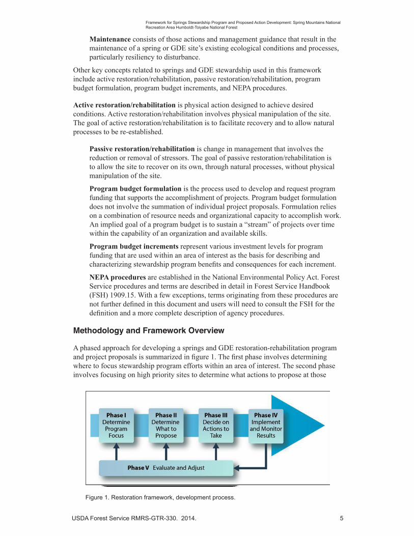
Methodology and Framework Overview
A phased approach for developing a springs and GDE restoration-rehabilitation program and project proposals is summarized in figure 1. The first phase involves determining where to focus stewardship program efforts within an area of interest. The second phase involves focusing on high priority sites to determine what actions to propose at those
Figure 1. Restoration framework, development process.

6 USDA Forest Service RMRS-GTR-330. 2014.
Framework for Springs Stewardship Program and Proposed Action Development: Spring Mountains National Recreation Area Humboldt-Toiyabe National Forest
sites. The third phase involves deciding on what actions to take and the fourth phase involves implementation of actions and monitoring results at specific sites. The fifth phase provides information that can be used to evaluate and adjust the other phases of the process.
The procedural steps associated with each phase of the restoration program development process are outlined in figure 2 and described in detail in the remainder of this document. Phase I of these methods was tested by using data from the SMNRA and Ashley National Forest.
The process presented here employs many concepts presented in the Watershed Condition Framework (USDA Forest Service 2011) and addresses similar needs to consistently represent conditions and restoration needs within the National Forest System (NFS), but at the site scale.
Key Point: Information presented for Phases II—V have not been tested and are provided to illustrate how the information used in program budget formulation (Phase I) can be used to develop agency proposed actions and their subsequent NEPA analysis and documentation. Because of time and contract limitations, Phase I analysis has relied on available information and will need to be reviewed and verified by SMNRA staff before these steps are considered as being completed.
Figure 2. Spring stewardship program formulation and proposed action development process.
Phase I—Determine Springs/GDE Stewardship Program Focus and Budget
Step 1—Determine Site Condition Class
Step 2—Determine Site Relative Significance
Step 3—Determine Site Stewardship Priority
Step 4—Characterize Stewardship Program Funding Needs
Step 5—Formulate Springs/GDE Stewardship Program Budgets
Phase II—Determine What Actions to Propose at Priority Springs/GDE Sites
Step 6—Determine Existing Condition
Step 7—Describe Desired Condition
Step 8—Determine the Purpose and Need for Action
Step 9—Develop a Proposed Action
Phase III—Decide Which Actions to Take
Step 10—Assess Environmental Effects
Step 11—Document Environmental Analysis (DM, EA or EIS)
Step 12—Issue NEPA Decision (DM, DN, or ROD)
Phase IV—Implement and Monitor Results
Step 13—Develop Implementation Guidance
Step 14—Implement Stewardship Actions
Step 15—Report Accomplishments
Step 16—Monitor Implementation and Effectiveness
Phase V—Evaluate and Adjust

USDA Forest Service RMRS-GTR-330. 2014. 7
Framework for Springs Stewardship Program and Proposed Action Development: Spring Mountains National Recreation Area Humboldt-Toiyabe National Forest
Springs Stewardship Program Formulation and Proposed Action Development Process
This document describes procedures used to develop a spring’s stewardship program budget and proposed actions for restoration/rehabilitation of high priority springs within the SMNRA.
Key Point: Methods described in this document are structured so that they could be used in other parts of the NFS and other public domain lands to provide a basis for consistently describing restoration program needs and a common foundation for developing maintenance and restoration-rehabilitation proposals for individual GDE sites. Program leads at the region and forest level would likely develop program funding proposals by using this process, with the goal of developing a program that leads to securing restoration project funding that could be used to implement site-specific proposals within a given are of interest.
Criteria used will need to be modified to address conditions and management concerns within the area of interest. Specific examples include: proposals for groundwater pumping or other water development that could affect GDEs or the evaluation of grazing impacts and prioritizing and planning restoration of grazed GDE sites.
This methodology is designed for application at broader scales to address needs for large numbers of GDE sites within an area of interest. Although many of the assessment and rehabilitation-restoration planning techniques described can be applied to a single GDE site, they are not designed for application at individual sites.
The framework’s methodology was designed to use existing, available data sets to assess a large number of springs and other GDEs as the basis for describing program budget needs and for prioritizing sites for maintenance and rehabilitation-restoration efforts. The methodology is designed to serve as foundation for describing restoration-rehabilitation needs and the purpose of restoration-rehabilitation project proposals used to formulate agency proposed actions that initiate the agency’s decision making under the National Environmental Policy Act (NEPA) procedures.
Phase I—Determine Springs/GDE Stewardship Program Focus and Budget
An important question facing managers on the Humboldt-Toiyabe National Forest, as in other locations, is where to focus GDE site maintenance and rehabilitation actions. Therefore, this phase was tested with actual spring inventory data from the SMNRA and the Ashley National Forest.
Ideally, site selection is done with an unbiased study design (such as systematic or random site selection) so that the data represent all of the springs for the area of interest. That was the case with the SMNRA data, which means that the data represent all of the springs of the SMNRA.
This phase involves five basic steps designed to determine relative priorities of springs or GDE sites and to characterize restoration program funding needs:
Step 1—Determine Site Condition Class
Step 2—Determine Site Relative Significance
Step 3—Determine Site Stewardship Priority
Step 4—Characterize Stewardship Program Funding Needs
Step 5—Formulate Spring/GDE Stewardship Program Budgets
8 USDA Forest Service RMRS-GTR-330. 2014.
Framework for Springs Stewardship Program and Proposed Action Development: Spring Mountains National Recreation Area Humboldt-Toiyabe National Forest
The objective of this phase is the characterization of spring/GDE site stewardship program funding needs to secure financial resources needed to accomplish spring or GDE site maintenance and rehabilitation. The premise is that without a sustained program of maintenance and rehabilitation within the area of interest, restoration efforts at individual sites will be ineffective in improving and maintaining the overall system of springs and GDE sites over time.
Key Point: Procedures described in this phase of the process were developed so they could be performed with GDE Level I Inventory data and other ancillary data and information commonly available to NFS administrative units.
Step 1: Determine Site Condition Class
The first step in the process was to assess the condition of each GDE site. This was intended to be a very general representation of the condition of the site to facilitate the prioritization process. This site condition classification was not intended to be a precise measure of a site’s condition and therefore should not be used to evaluate status or trend.
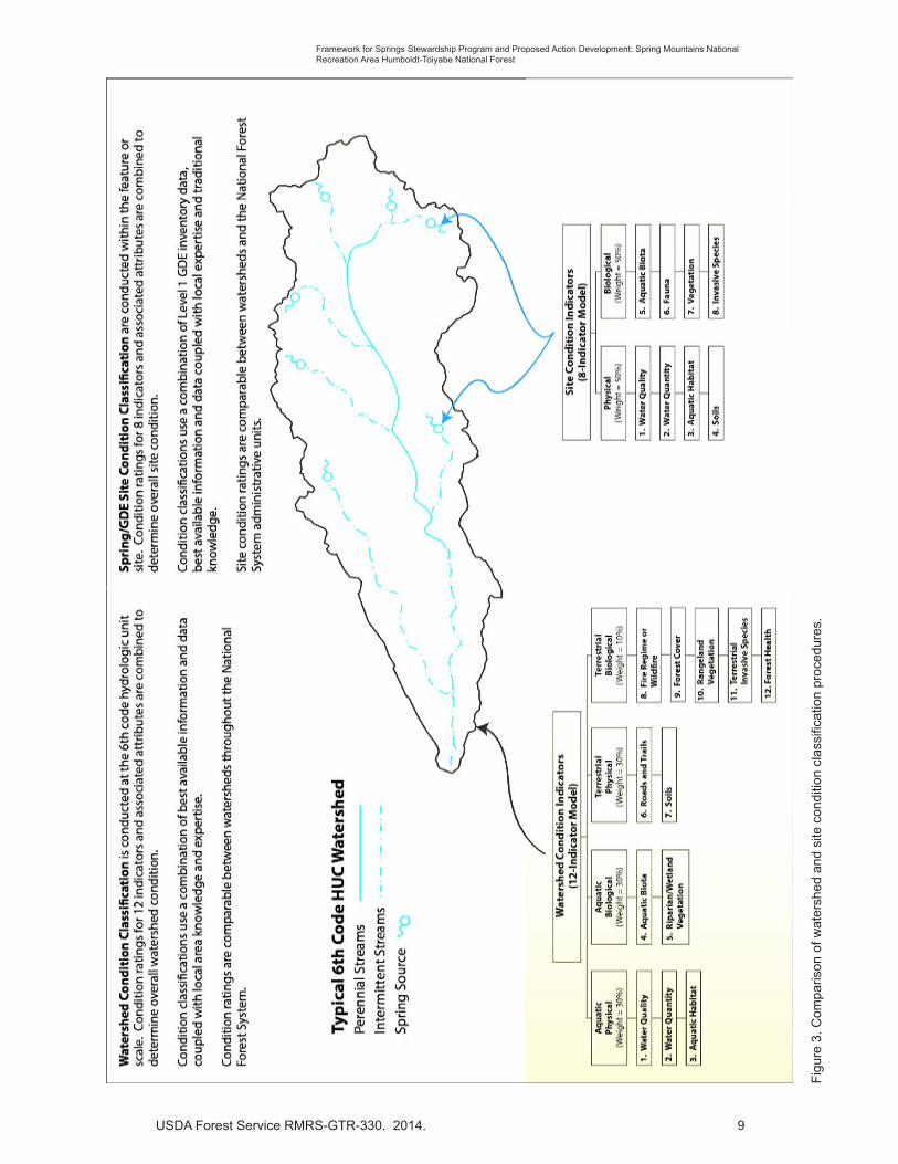
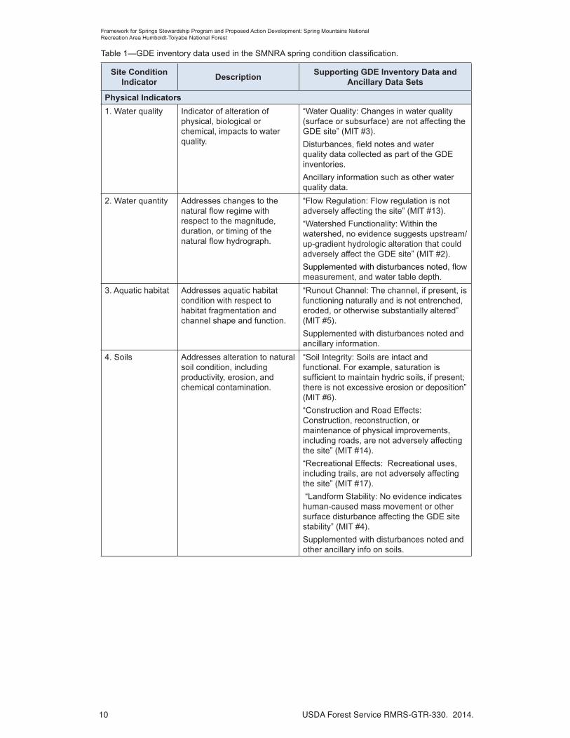
The site condition classification uses indicators similar to those used in the Watershed Condition Classification Technical Guide (Potyondy and Geier 2011) that is part of the Watershed Condition Framework (USDA Forest Service 2011). Figure 3 displays the relationships and indicator sets used in Watershed Condition Assessment and Spring/GDE Site Condition Assessments. Springs or GDE site condition classes are determined for individual sites within individual watersheds. The 12 aquatic and terrestrial indicators used in the Watershed Condition Assessment process are summarized in figure 3. A total of eight indicators of physical and biological conditions are used in the springs/GDE site classification process (table 1).
Key Point: Watershed Condition Class determinations are made at the watershed scale and assess both aquatic and terrestrial conditions, whereas site condition classifications consider indicator conditions only within the spring or GDE site.
In designing the site condition classification, seven of the twelve Watershed Condition Assessment indicators were selected for use in the springs/GDE site condition classification because they apply at the site-level (see fig. 3). The other five watershed-scale indicators (Roads and Trails, Fire Regime or Wildfire, Forest Cover, Rangeland Vegetation, and Forest Health) were not used because they apply to the terrestrial uplands at the watershed-level rather than the site-scale. An additional indicator (which makes a total of eight) related to “Fauna” was added to the site condition classification to assess non-aquatic biota (such as mammals, birds, and insects ) that may utilize the spring or GDE site. The Watershed Condition Classification indicator “Terrestrial Invasive Species” was broadened to include aquatic, as well as terrestrial, invasive species and was described as “Invasive Species” to account for invasive species effects on the condition of a spring/GDE site.
These indicators were then grouped into two categories (Physical and Biological) versus the four categories used in the Watershed Condition Assessment (Aquatic Physical, Aquatic Biological, Terrestrial Physical, and Terrestrial Biological). Weighting of indicator scores within these two categories was equal, just as the Aquatic Physical and Aquatic Biological categories had equal weight in the Watershed Condition Assessment process.
USDA Forest Service RMRS-GTR-330. 2014. 9
Framework for Springs Stewardship Program and Proposed Action Development: Spring Mountains National Recreation Area Humboldt-Toiyabe National Forest
Fig
ure
3. C
ompa
rison
of w
ater
shed
and
site
con
ditio
n cl
assi
ficat
ion
proc
edur
es.
10 USDA Forest Service RMRS-GTR-330. 2014.
Framework for Springs Stewardship Program and Proposed Action Development: Spring Mountains National Recreation Area Humboldt-Toiyabe National Forest
Table 1—GDE inventory data used in the SMNRA spring condition classification.
Site Condition Indicator
Description Supporting GDE Inventory Data and
Ancillary Data Sets
Physical Indicators
1. Water quality Indicator of alteration of physical, biological or chemical, impacts to water quality.
“Water Quality: Changes in water quality (surface or subsurface) are not affecting the GDE site” (MIT #3).
Disturbances, field notes and water quality data collected as part of the GDE inventories.
Ancillary information such as other water quality data.
2. Water quantity Addresses changes to the natural flow regime with respect to the magnitude, duration, or timing of the natural flow hydrograph.
“Flow Regulation: Flow regulation is not adversely affecting the site” (MIT #13).
“Watershed Functionality: Within the watershed, no evidence suggests upstream/up-gradient hydrologic alteration that could adversely affect the GDE site” (MIT #2).
Supplemented with disturbances noted, flow measurement, and water table depth.
3. Aquatic habitat Addresses aquatic habitat condition with respect to habitat fragmentation and channel shape and function.
“Runout Channel: The channel, if present, is functioning naturally and is not entrenched, eroded, or otherwise substantially altered” (MIT #5).
Supplemented with disturbances noted and ancillary information.
4. Soils Addresses alteration to natural soil condition, including productivity, erosion, and chemical contamination.
“Soil Integrity: Soils are intact and functional. For example, saturation is sufficient to maintain hydric soils, if present; there is not excessive erosion or deposition” (MIT #6).
“Construction and Road Effects: Construction, reconstruction, or maintenance of physical improvements, including roads, are not adversely affecting the site” (MIT #14).
“Recreational Effects: Recreational uses, including trails, are not adversely affecting the site” (MIT #17).
“Landform Stability: No evidence indicates human-caused mass movement or other surface disturbance affecting the GDE site stability” (MIT #4).
Supplemented with disturbances noted and other ancillary info on soils.

USDA Forest Service RMRS-GTR-330. 2014. 11
Framework for Springs Stewardship Program and Proposed Action Development: Spring Mountains National Recreation Area Humboldt-Toiyabe National Forest
Table 1 (continued)—GDE inventory data used in the SMNRA spring condition classification.
Site Condition Indicator
Description Supporting GDE Inventory Data and
Ancillary Data Sets
Biological Indicators
5. Aquatic Biota Addresses the distribution, structure, and density of native and introduced aquatic fauna.
Insofar as they address aquatic fauna:
“Faunal Species: Anticipated aquatic and terrestrial faunal species associated with the site environment are present” (MIT #10).
“Threatened, endangered, or sensitive species; SOI/SOC; or focal faunal species: Anticipated faunal species are present (will vary by ecological region and will require some baseline information)” (MIT #11).
Supplemented with observations and notes on aquatic fauna.
6. Fauna Addresses the distribution, structure, and density of native and introduced terrestrial fauna at the GDE site.
Insofar as they address terrestrial fauna:
“Faunal Species: Anticipated aquatic and terrestrial faunal species associated with the site environment are present” (MIT #10).
“Threatened, endangered, or sensitive species; SOI/SOC; or focal faunal species: Anticipated faunal species are present (will vary by ecological region and will require some baseline information)” (MIT #11).
Supplemented with observations and notes on terrestrial fauna.
7. Riparian-Wetland Vegetation
Addresses the function and condition of riparian vegetation along streams, waterbodies, and wetlands.
“Vegetation Composition: The site includes anticipated cover of plant species associated with the site environment, and no evidence suggests that upland species are replacing hydric species” (MIT #7).
“Vegetation Condition: Vegetation exhibits seasonally appropriate health and vigor” (MIT #8).
“Threatened, endangered, or sensitive species; SOI/SOC; or focal floral species: Anticipated floral species are present (will vary by ecological region and will require some baseline information)” (MIT #9).
Supplemented with other information on the condition and abundance of wetland and native vegetation.
8. Invasive Species
Addresses potential effects to soil, vegetation, and water resources due to invasive species (including vertebrates, invertebrates, and plants).
“Invasive Species: Invasive floral and faunal species are not established at the site” (MIT #12) in terms of non-aquatic biota.
Supplemented with observations of invasive species and Natural Resource Manager-Terra (noxious weeds and invasive species).

12 USDA Forest Service RMRS-GTR-330. 2014.
Framework for Springs Stewardship Program and Proposed Action Development: Spring Mountains National Recreation Area Humboldt-Toiyabe National Forest
Appendix 1 contains a description of springs/GDE site condition indicators and rule sets for determining conditions at individual sites using GDE Level I inventory data and information and ancillary data sets commonly available to most NFS administrative units.
The site condition classification process described in this framework was developed so the analysis could be conducted by using data collected using the GDE Level I Inventory Field Guide (USDA Forest Service 2012b), or data collected using the GDE Level II Inventory Field Guide (USDA Forest Service 2012a)
Key GDE Level I Inventory Field Guide data used in the site condition classification include the following:
• The management indicator tool or MIT that consists of a series 25 questions (answered true or false) about the effects of management and other uses and activities at a spring or GDE site for the following categories: hydrology, geomorphology and soils, biology, disturbances, and administrative context. Some of those MIT questions address the eight site condition indicators and they are listed in table 1 (the MIT question and number that applies to each indicator are in the right-hand column).
• Information on disturbances observed as part of the GDE inventory was also used to determine or refine the site condition scores as noted in table 1.
Figure 4 illustrates how data from various sources are used to develop a rating for individual indicators. Table 1 describes how information from Level I Springs/GDE site inventories is used to assess springs/GDE site indicators for an area of interest. The table also identifies other ancillary data that could also be used to refine the site condition classification for each indicator, such as other data or reports from other studies (e.g., annual aerial insect and disease surveys).
Descriptions of each indicator and detailed rule sets developed for the SMNRA spring condition classification are presented in Appendix 1.
Figure 4. Data used to develop site condition indicator ratings.

USDA Forest Service RMRS-GTR-330. 2014. 13
Framework for Springs Stewardship Program and Proposed Action Development: Spring Mountains National Recreation Area Humboldt-Toiyabe National Forest
Springs or GDE site condition class was determined using a similar process to the Watershed Condition Class Technical Guide (Potyondy and Geier 2011). That process uses qualitative data and converts it to a numeric score that is then used to calculate a composite score used to determine the condition class.
Condition classes for springs/GDE sites were determined by the following:
1. GDE Level II data and ancillary data were used to rate each of the eight indicators. A “yes” (good) answer was assigned a 1 value, and a “no” (poor) answer was assigned a 3 value. In some cases, disturbance or other ancillary data were used to change value to a 2 (from either 1 or 3).
2. The average of the indicator values within each of the Physical and Biological categories was then calculated.
3. The values for the two indicator categories were averaged (rounded to one decimal) to obtain a site condition score.
4. Sites were then assigned to a condition class based on the site condition score. The following class intervals were used to be consistent with those used in Watershed Condition Classification:
Site Condition Class 1 (Good) = 1.0 to 1.6
Site Condition Class 2 (Fair) = 1.7 to 2.2
Site Condition Class 3 (Poor) = 2.3 to 3.0
Key Point: The springs or GDE site condition scores are the result of qualitative assessment intended for determination of the site condition class. These scores or values should not be used to develop monitoring objectives or used to quantitatively describe sites and their conditions. Establishment of objectives for site or program monitoring would require quantitative data that are fully supported by and adequate statistical and sampling design.
Step 2: Determine Site Relative Significance
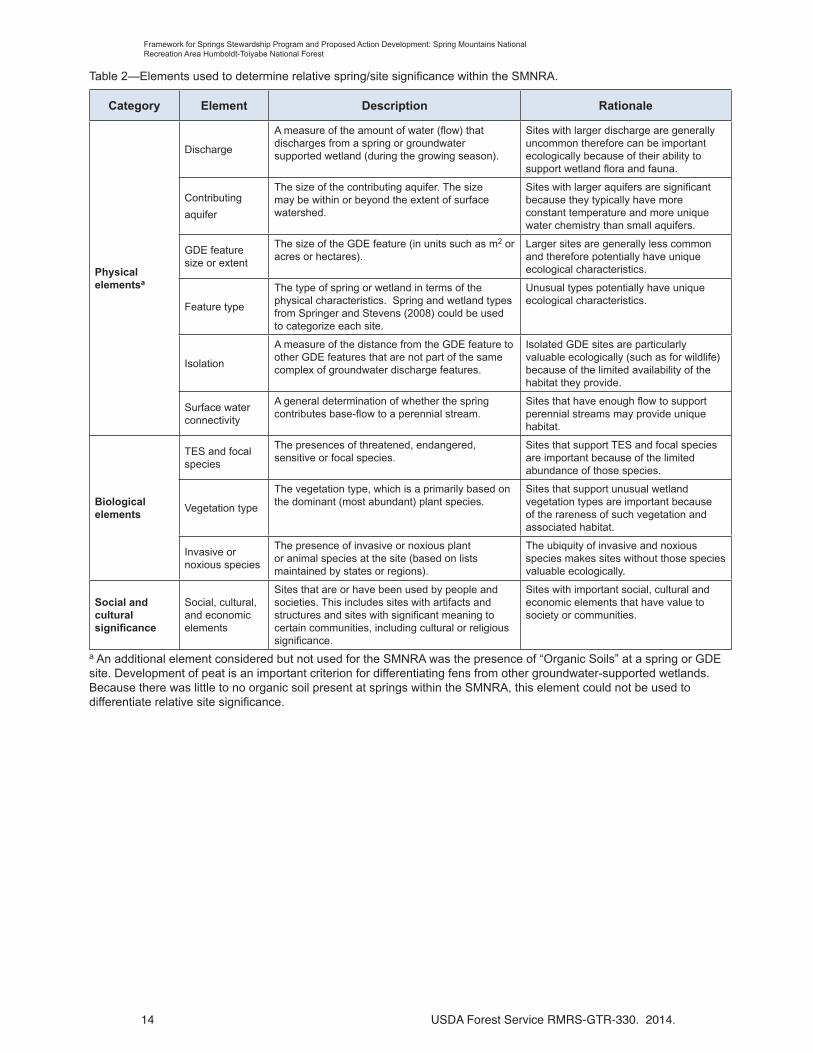
The next step was to determine the relative significance of springs/GDE sites within the area of interest to prioritize the sites for management activities. Significance “elements” appropriate to the SMNRA were developed to evaluate the rarity and importance of physical, biological, and social/cultural/economic characteristics of each site and the relationship of sites to each other (relative site significance). The significance elements are listed in table 2 and described in more detail in Appendix 2.
Because this is “relative” site significance, the scoring system was based on the range of values for the sites in the SMNRA. To determine the highest significance sites, the range of values was divided into thirds (tertiles, which is similar in concept to commonly used quartiles) and each third was associated with a relative-site significance class:
High = Total score in lowest third of range of values
Medium = Total score in middle third of range of values
Low = Total score in highest third of range of values
As with site condition, relative site significance is a qualitative assessment that was only intended for this prioritization process. Comparing site significance within the area of interest, the SMNRA in this case, is appropriate and useful; however, it would not be appropriate to compare significance for sites from different areas. Different elements would need to be developed for other geographical areas.
14 USDA Forest Service RMRS-GTR-330. 2014.
Framework for Springs Stewardship Program and Proposed Action Development: Spring Mountains National Recreation Area Humboldt-Toiyabe National Forest
Table 2—Elements used to determine relative spring/site significance within the SMNRA.
Category Element Description Rationale
Physical elementsa
Discharge
A measure of the amount of water (flow) that discharges from a spring or groundwater supported wetland (during the growing season).
Sites with larger discharge are generally uncommon therefore can be important ecologically because of their ability to support wetland flora and fauna.
Contributing
aquifer
The size of the contributing aquifer. The size may be within or beyond the extent of surface watershed.
Sites with larger aquifers are significant because they typically have more constant temperature and more unique water chemistry than small aquifers.
GDE feature size or extent
The size of the GDE feature (in units such as m2 or acres or hectares).
Larger sites are generally less common and therefore potentially have unique ecological characteristics.
Feature type
The type of spring or wetland in terms of the physical characteristics. Spring and wetland types from Springer and Stevens (2008) could be used to categorize each site.
Unusual types potentially have unique ecological characteristics.
Isolation
A measure of the distance from the GDE feature to other GDE features that are not part of the same complex of groundwater discharge features.
Isolated GDE sites are particularly valuable ecologically (such as for wildlife) because of the limited availability of the habitat they provide.
Surface water connectivity
A general determination of whether the spring contributes base-flow to a perennial stream.
Sites that have enough flow to support perennial streams may provide unique habitat.
Biological elements
TES and focal species
The presences of threatened, endangered, sensitive or focal species.
Sites that support TES and focal species are important because of the limited abundance of those species.
Vegetation type
The vegetation type, which is a primarily based on the dominant (most abundant) plant species.
Sites that support unusual wetland vegetation types are important because of the rareness of such vegetation and associated habitat.
Invasive or noxious species
The presence of invasive or noxious plant or animal species at the site (based on lists maintained by states or regions).
The ubiquity of invasive and noxious species makes sites without those species valuable ecologically.
Social and cultural significance
Social, cultural, and economic elements
Sites that are or have been used by people and societies. This includes sites with artifacts and structures and sites with significant meaning to certain communities, including cultural or religious significance.
Sites with important social, cultural and economic elements that have value to society or communities.
a An additional element considered but not used for the SMNRA was the presence of “Organic Soils” at a spring or GDE site. Development of peat is an important criterion for differentiating fens from other groundwater-supported wetlands. Because there was little to no organic soil present at springs within the SMNRA, this element could not be used to differentiate relative site significance.

USDA Forest Service RMRS-GTR-330. 2014. 15
Framework for Springs Stewardship Program and Proposed Action Development: Spring Mountains National Recreation Area Humboldt-Toiyabe National Forest
Step 3: Determine Site Stewardship Priority
After the GDE site condition and relative site significance were determined, the relative priority of GDE sites for stewardship program investments was established using a ranking process. Using the approach described in the Watershed Condition Framework (USDA Forest Service 2011), priority was placed on those sites that were in good condition. This follows the principle that “ecosystems, like Humpty Dumpty, are vastly easier to preserve than they are to reassemble” (Black 2003 as cited in Lavigne 2005) and that “it is always easier to protect ecosystems and ecological health than to restore it (Meine 2004 as cited in Lavigne 2005).
Table 3 was used to sort individual sites into different priority rankings by intersecting site condition ratings and relative site significance for the SMNRA. The highest priority ranking was given to sites that are both in good condition and have high relative ecological significance. Sites with the highest priority sites for stewardship investments are located in the upper left corner of table 3 and lowest priority sites in the lower right part of the table.
The pattern of priority ranking assignments places emphasis on stewardship actions associated with those sites with a “good” site condition rating of “high” or “medium” significance because of lower costs associated with monitoring and maintaining current conditions. The second area of focus within the priority setting process are those sites in condition class 2 with a site significance of “high” or “medium” because of a combination of their significance and the relative lower cost of restoring or rehabilitating these sites using the “Humpty Dumpty” model – easier to put back together than sites in “poor” condition. The third focus area within the priority setting process are those sites of “low” relative significance that are in “good” or “fair” condition because they are less ecologically significant than sites in the higher priority groups and can still be restored or rehabilitated with lower total investment costs. The lowest priority group consists of those sites in “poor” condition regardless of their significance because of the significantly higher cost of restoration or rehabilitation.
Table 3—Determining GDE site treatment priority rankings.
GDE Site
Significance
GDE Site Condition Class 1
(Good; Functioning Properly)
GDE Site Condition Class 2
(Fair; Functioning At Risk)
GDE Site Condition Class 3
(Poor; Impaired)
High Rank = A Rank = C Rank = G
Medium Rank = B Rank = D Rank = H
Low Rank = E Rank = F Rank = I
Note: Letters are used for the ranking to avoid confusion with condition class ratings.
Step 4: Characterize Stewardship Program Funding Needs
This step in the process considers the condition of the watershed surrounding individual sites to provide management context used to characterize program funding needs. For each spring, the watershed condition classification for the watershed in which the spring is located and the site’s condition and relative significance is used to determine the “budget class” associated with each site. Budget classes are then used to characterize stewardship program funding needs.

16 USDA Forest Service RMRS-GTR-330. 2014.
Framework for Springs Stewardship Program and Proposed Action Development: Spring Mountains National Recreation Area Humboldt-Toiyabe National Forest
The rationale for this approach stems from the management strategy outlined in the Watershed Condition Framework. Just as “good” condition watersheds are a high priority for stewardship investments, “good” condition sites have a higher priority within restoration programs. Spending time and money to maintain and restore sites within “good” condition watersheds is a wise investment because those sites are less likely to be negatively impacted by problems in the watershed. Conversely, spending time and money on “poor” condition sites in “poor” condition watersheds warrants a lower priority for expending limited resources.
Criteria for assignment of individual sites to budget classes are presented in table 4, with the highest budget class priority in the upper left portion of the table and lowest priority budget class in the lower right part of the table.
Within the area of interest, each site is assigned to a specific budget class with a similar stewardship focus and rationale for stewardship actions as described in table 5.
In addition to helping characterize restoration needs, knowledge about the relative importance of individual sites fosters protection and conservation of these sites that are in good condition and have high significance.
Table 4—Characterization of springs stewardship program budget needs using budget classes.
Watershed Condition
Class
Site Treatment Priority Rankings
A B C D E F G H I
1 M-1 M-1 R-1 R-2 R-3 R-4 R-4 R-4 R-4
2 M-1 M-1 R-2 R-3 R-4 R-4 R-4 R-4 R-4
3 M-2 M-2 R-3 R-4 R-4 R-4 R-4 R-4 R-4Note: M = Maintenance and R = Restoration. Numbers represent budget classes within each cell.

USDA Forest Service RMRS-GTR-330. 2014. 17
Framework for Springs Stewardship Program and Proposed Action Development: Spring Mountains National Recreation Area Humboldt-Toiyabe National Forest
Step 5: Formulate Springs/GDE Stewardship Program Budgets
The goal of this step in the process is to portray total stewardship (maintenance and rehabilitation) program needs for all GDE sites inventoried within the SMNRA. Program funding needs are then represented as increments within the total program that serve as the basis for requesting funding from various sources. Program levels or increments can then be represented as shown in the following example:
Base Program = Maintenance Class M-1 and M-2 + Restoration Class R-1
Program Increment 1 = Restoration Class R-2 + Base Program
Program Increment 2 = Restoration Class R-3 + Base Program + Program Increment 1
Total Program Needs = All Maintenance and Rehabilitation needs, including Restoration Class R-4
Table 5—Springs/GDE stewardship program budget class descriptions.
Stewardship program budget classes
Stewardship focus Rationale
Maintenance Class 1
(M-1)
Site condition: good
Significance: high or medium
Watershed CONDITION CLASS: good (class 1) or fair (class 2)
Departure from desired conditions is low while the significance of sites is relatively high. Maintenance costs are relatively low. These are core watershed features whose function must be maintained to sustain overall watershed condition. In some cases no action may be needed to maintain these sites. Awareness of these sites, and their unique characteristics, can facilitate their conservation and protection.
Maintenance Class 2
(M-2)
Site condition: good
Significance: high or medium
Watershed condition class: poor (WCC rating 3)
These are core watershed features whose function must be maintained to provide an anchor point for future restoration/rehabilitation of these watersheds. Without these sites remaining intact, the ability to restore proper watershed function is not feasible.
Restoration Class 1
(R-1)
Site condition: fair
Significance: high
Watershed condition class: good (WCC rating of 1)
Restoration of these high significance sites within watersheds that are functioning at risk could benefit the overall function of the watershed.
Restoration Class 2
(R-2)
Site condition: fair
Significance: high or medium
Watershed condition class: good or fair (WCC rating 1 or 2)
Efforts to improve these sites that are in fair condition, and of medium to high significance, can help improve watershed condition.
Restoration Class 3
(R-3)
Site condition: good or fair
Significance: various
Watershed condition class: various
Investments in rehabilitation and restoration could maintain or improve individual sites, but overall condition and significance of these sites and watersheds warrant a low investment priority.
Restoration Class 4
(R-4)
In combination, Site condition, Significance, and Watershed condition class are low or poor
The generally poor condition (site and watershed) and low significance of these sites warrant the lowest investment priority.

18 USDA Forest Service RMRS-GTR-330. 2014.
Framework for Springs Stewardship Program and Proposed Action Development: Spring Mountains National Recreation Area Humboldt-Toiyabe National Forest
Program increments can then be represented in both tabular and graphic form, as illustrated in figure 5 and table 6. A representation of program needs for different program funding horizons can also be displayed with 3-, 5-, and 10-year program horizons as depicted in table 6.
Figure 5. Hypothetical springs/GDE stewardship program cost representation (information presented in this table is for illustration only; program funding amounts are hypothetical and do not represent actual cost projections).
Table 6—Hypothetical springs/GDE stewardship program increments (information presented in this table is for illustration only; program funding amounts are hypothetical and do not represent actual cost projections).
Program LevelTotal
Funding Needs
Annual Needs
3-Year Program
Annual Needs
5-Year Program
Annual Needs
10-Year Program
Base program $94,550 $31,517/year $18,910/year $9,455/year
Increment 1 $308,718 $102,906/year $61,744/year $30, 872/year
Increment 2 $616,000 $205,333/year $123,200/year $61,600/year
Total program $2,275,000 $758,333/year $455,000/year $227,500/year

USDA Forest Service RMRS-GTR-330. 2014. 19
Framework for Springs Stewardship Program and Proposed Action Development: Spring Mountains National Recreation Area Humboldt-Toiyabe National Forest
Phase II—Determine What Site-Specific Actions to Propose at Priority Springs/GDEs
Phase II involves identification and proposal of actions to restore or rehabilitate a spring or other GDE site or group of sites to achieve or move toward desired conditions. Management actions designed to move springs/GDE sites toward desired conditions is important because of the valuable ecological functions of these systems including: sustaining endemic species; providing refugia for maintaining biological diversity; serving as source of individual species to recolonize adjacent sites following disturbance; sequestration of carbon; maintaining base streamflows in a watershed; providing water sources in large arid expanses; and as barometers of ecosystem health. The site condition indicators described in the steps below provide a tool to document impairment to these functions and the identification of spring/GDE site restoration-rehabilitation proposals.
Key Point: Phases II through IV have not been tested and are presented to demonstrate how information from Phase I can be used in the development, implementation, and monitoring of proposed actions.
Developing proposed restoration actions involves the following steps:
Step 6—Determine Existing Condition
Step 7—Describe Desired Condition
Step 8—Determine the Purpose and Need for Action
Step 9—Develop a Site-Specific Proposed Action
Key Point: Unlike the analysis conducted in Phase I, Phases II through IV require data from GDE Level II inventories to accomplish these analysis steps.
Information provided in the following appendices includes more detail and are referenced in one or more of the steps included in Phase II:
Appendix 1—Rule Sets for Determining Spring/GDE Site Conditions
Appendix 3—SMNRA Springs/Riparian Management Response Framework
Appendix 4—Nevada Springs Restoration Practices
Step 6—Determine Existing Condition
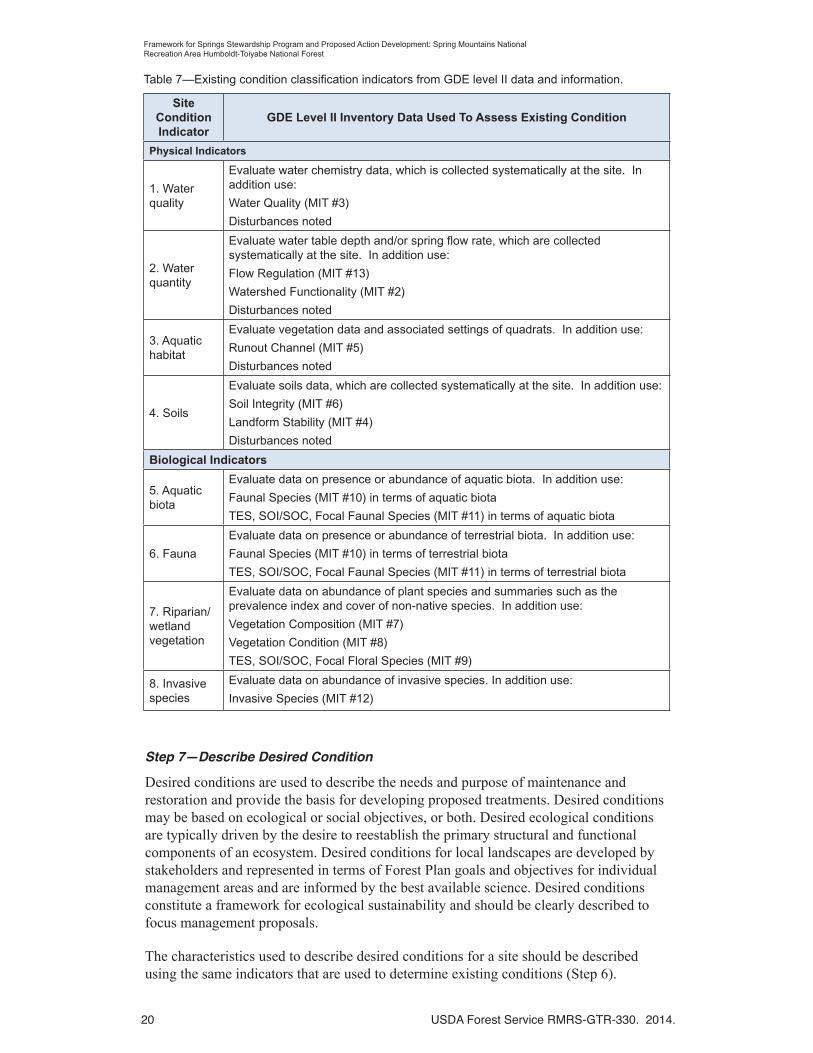
At this point in the process, more detailed data about the site should be collected using the GDE Level II Inventory Field Guide. Unlike Step 1 that uses GDE Level I data, Step 6 of the process applies this improved data set in characterizing the existing condition of an individual site using the rule sets described in Appendix 1.
The GDE Level II inventory data provide the ability to characterize vegetation, soil, hydrology, fauna, and disturbances at the site. Table 7 describes GDE Level II data and information that can be used to describe the existing condition of springs or GDE site indicators. These data can be compared to desired conditions (Step 7) to identify what needs to be done to achieve desired conditions (Step 8). The GDE Level II data can also provide a baseline of the current conditions that can be compared to conditions after management actions are implemented. This before and after comparison is a valuable tool in evaluating the success of restoration efforts (see Phase IV).
20 USDA Forest Service RMRS-GTR-330. 2014.
Framework for Springs Stewardship Program and Proposed Action Development: Spring Mountains National Recreation Area Humboldt-Toiyabe National Forest
Step 7—Describe Desired Condition
Desired conditions are used to describe the needs and purpose of maintenance and restoration and provide the basis for developing proposed treatments. Desired conditions may be based on ecological or social objectives, or both. Desired ecological conditions are typically driven by the desire to reestablish the primary structural and functional components of an ecosystem. Desired conditions for local landscapes are developed by stakeholders and represented in terms of Forest Plan goals and objectives for individual management areas and are informed by the best available science. Desired conditions constitute a framework for ecological sustainability and should be clearly described to focus management proposals.
The characteristics used to describe desired conditions for a site should be described using the same indicators that are used to determine existing conditions (Step 6).
Table 7—Existing condition classification indicators from GDE level II data and information.
Site Condition Indicator
GDE Level II Inventory Data Used To Assess Existing Condition
Physical Indicators
1. Water quality
Evaluate water chemistry data, which is collected systematically at the site. In addition use:
Water Quality (MIT #3)
Disturbances noted
2. Water quantity
Evaluate water table depth and/or spring flow rate, which are collected systematically at the site. In addition use:
Flow Regulation (MIT #13)
Watershed Functionality (MIT #2)
Disturbances noted
3. Aquatic habitat
Evaluate vegetation data and associated settings of quadrats. In addition use:
Runout Channel (MIT #5)
Disturbances noted
4. Soils
Evaluate soils data, which are collected systematically at the site. In addition use:
Soil Integrity (MIT #6)
Landform Stability (MIT #4)
Disturbances noted
Biological Indicators
5. Aquatic biota
Evaluate data on presence or abundance of aquatic biota. In addition use:
Faunal Species (MIT #10) in terms of aquatic biota
TES, SOI/SOC, Focal Faunal Species (MIT #11) in terms of aquatic biota
6. Fauna
Evaluate data on presence or abundance of terrestrial biota. In addition use:
Faunal Species (MIT #10) in terms of terrestrial biota
TES, SOI/SOC, Focal Faunal Species (MIT #11) in terms of terrestrial biota
7. Riparian/wetland vegetation
Evaluate data on abundance of plant species and summaries such as the prevalence index and cover of non-native species. In addition use:
Vegetation Composition (MIT #7)
Vegetation Condition (MIT #8)
TES, SOI/SOC, Focal Floral Species (MIT #9)
8. Invasive species
Evaluate data on abundance of invasive species. In addition use:
Invasive Species (MIT #12)
USDA Forest Service RMRS-GTR-330. 2014. 21
Framework for Springs Stewardship Program and Proposed Action Development: Spring Mountains National Recreation Area Humboldt-Toiyabe National Forest
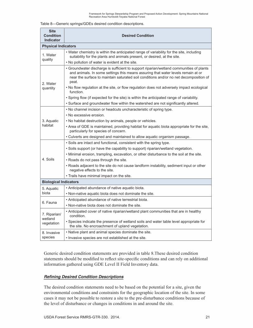
Table 8—Generic springs/GDEs desired condition descriptions.
Site Condition Indicator
Desired Condition
Physical Indicators
1. Water quality
• Water chemistry is within the anticipated range of variability for the site, including suitability for the plants and animals present, or desired, at the site.
• No pollution of water is evident at the site.
2. Water quantity
• Groundwater discharge is sufficient to support riparian/wetland communities of plants and animals. In some settings this means assuring that water levels remain at or near the surface to maintain saturated soil conditions and/or no net decomposition of peat.
• No flow regulation at the site, or flow regulation does not adversely impact ecological function.
• Spring flow (if expected for the site) is within the anticipated range of variability.
• Surface and groundwater flow within the watershed are not significantly altered.
3. Aquatic habitat
• No channel incision or headcuts uncharacteristic of spring type.
• No excessive erosion.
• No habitat destruction by animals, people or vehicles.
• Area of GDE is maintained, providing habitat for aquatic biota appropriate for the site, particularly for species of concern.
• Culverts are designed and maintained to allow aquatic organism passage.
4. Soils
• Soils are intact and functional, consistent with the spring type.
• Soils support (or have the capability to support) riparian/wetland vegetation.
• Minimal erosion, trampling, excavation, or other disturbance to the soil at the site.
• Roads do not pass through the site.
• Roads adjacent to the site do not cause landform instability, sediment input or other negative effects to the site.
• Trails have minimal impact on the site.
Biological Indicators
5. Aquatic biota
• Anticipated abundance of native aquatic biota.
• Non-native aquatic biota does not dominate the site.
6. Fauna• Anticipated abundance of native terrestrial biota.
• Non-native biota does not dominate the site.
7. Riparian/wetland vegetation
• Anticipated cover of native riparian/wetland plant communities that are in healthy condition.
• Species indicate the presence of wetland soils and water table level appropriate for the site. No encroachment of upland vegetation.
8. Invasive species
• Native plant and animal species dominate the site.
• Invasive species are not established at the site.
Generic desired condition statements are provided in table 8.These desired condition statements should be modified to reflect site-specific conditions and can rely on additional information gathered using GDE Level II Field Inventory data.
Refining Desired Condition Descriptions
The desired condition statements need to be based on the potential for a site, given the environmental conditions and constraints for the geographic location of the site. In some cases it may not be possible to restore a site to the pre-disturbance conditions because of the level of disturbance or changes in conditions in and around the site.
22 USDA Forest Service RMRS-GTR-330. 2014.
Framework for Springs Stewardship Program and Proposed Action Development: Spring Mountains National Recreation Area Humboldt-Toiyabe National Forest
Desired condition descriptions for each of the indicators for the desired level of functionality may be refined using pre-disturbance conditions where historical information is available or from reference sites. Specific sources of information on desired condition include:
• Knowledge about the site’s natural condition based on data, historic photographs, aerial photography, early site descriptions, surveys, journals, and, information gleaned from literature search, or personal accounts obtained from individuals knowledgeable about the history of the site.
• Conditions at a comparable reference site – a site that is minimally impacted by human activities or other factors such as introduced or invasive species.
It may be desirable to describe desired conditions to reflect a management determination that resulted in an irreversible condition (e.g., establishing a spring box for a community potable water supply) for some indicators or attributes. In these instances, desired conditions can be developed using the condition classification descriptions for each indicator or attribute in Appendix 1 at the “fair” or “poor” level.
Step 8—Determine the Purpose and Need for Action
Once the desired conditions are identified they can be compared to the existing conditions to determine those indicators needing improvement and the purpose of different actions. This information is used to propose actions needed to improve the site’s conditions toward the desired conditions (Step 7). Examples of conditions that prevent a site from meeting the desired condition include:
• Water quality impairment,
• Flow alteration,
• Excessive erosion and sedimentation,
• Presence of non-native or invasive plant or animal species,
• Damage to vegetation or soil (by animals, vehicles, or people),
• Structures or activities that alter the hydrology of the site, and
• Roads or trails in or near the site that affect hydrology or produce sediment.
The impairments listed above, which are used to assess and remedy conditions that are not at desired levels, will be identified and addressed using the indicators described in this framework.
Maintenance and rehabilitation needs can be identified using table 9 to describe the need and purpose associated with each of the indicators used to assess the existing condition (Step 6) and desired condition (Step 7). The agency administrator or responsible official determines which of these needs to respond to within the overall context of managing the administrative unit. Although needs may exist on an individual site, the responsible official determines which of these to pursue as part of an agency proposal.
In developing and describing proposed actions, it is important to consistently describe the purpose of restoration using common terminology. The Key Concepts and Terminology section of this framework provides terms and definitions related to restoration. An example of how to identify the need for restoration-rehabilitation actions and their purpose is presented in table 9. This information (purpose and need) is used to formulate a proposed action (Step 9).

USDA Forest Service RMRS-GTR-330. 2014. 23
Framework for Springs Stewardship Program and Proposed Action Development: Spring Mountains National Recreation Area Humboldt-Toiyabe National Forest
Table 9—Hypothetical restoration and rehabilitation project need and purpose for a rheocrene spring.
Site Condition Indicator
Existing Condition
Desired Condition
Maintenance or Rehabilitation Need and Purpose of Actions
Physical Indicators
1. Water quality
Poor Good Need: The primary factors affecting water quality are damage to vegetation and soil caused by off-highway vehicle (OHV) use and ungulates. These disturbances in and adjacent to the spring site and outflow channel have led to erosion, channel widening, sediment in the channel and associated impairment of water quality.
Purpose: Reduce unauthorized OHV use off designated routes upslope and divert overland flow from existing roads that provides sediment sources into the spring, and stabilize sediment sources. Maintain fences to limit ungulate use of riparian vegetation.
2. Water quantity
Good Good No action needed
3. Aquatic habitat
Good Good No action needed
4. Soils Poor Fair Need: Roads that are open to OHV use and the FDR # XXX traverses this site. Sedimentation and culvert blockage on the FDR # XXX road have channeled overland flow along the road, causing erosion and sediment delivery to the creek. OHV use on designated routes above the spring source is incising and deepening the roadway channeling overland flow into the spring source.
Purpose: Improve compliance with motor vehicle use restrictions. Repair road drainage and replace blocked culvert with hard native-surface low-water crossing.
Biological Indicators
5. Aquatic biota Fair Good Need: Recovery from past disturbance to the outflow channel has led to a proliferation of watercress, an aquatic colonizing species that may temporarily inhibit springsnails, but is useful for trapping sediment and re-building stream banks. Non-native fish have been introduced and may affect springsnails and may affect springsnail habitat, however, these effects are not understood.
Purpose: Time without disturbance is needed for later successional plant species to establish on the stream margins, displacing watercress, and continuing the development of a narrower, deeper channel that will support aquatic biota. Restocking of non-native fish should be discouraged.
6. Fauna Poor Good Need: Fences built in the past were not built to exclude elk. Therefore the fences need to be modified to keep elk out. Alternative water sources are available downstream from the existing exclosure.
Purpose: Prevent elk from entering the spring/riparian zone and causing damage to vegetation, soil, streambanks and aquatic organisms.
7.Riparian/wetland vegetation
Fair Good Need: Excessive disturbance in and around the spring orifice by wild horses, burros, and elk have altered the native plant communities, which has likely led to a decline in some butterfly host and nectar plant species.
Purpose: Exclude wild horses, burros, and elk from the spring site. Design the exclosure to take advantage of natural features and anchor points.
Wild horse and burro populations continue to exceed desired AMLs resulting in unacceptable impacts to riparian vegetation and aquatic biota (springsnails) therefore continued maintenance of the exclosure is needed.
8. Invasive species
Good Good No action needed

24 USDA Forest Service RMRS-GTR-330. 2014.
Framework for Springs Stewardship Program and Proposed Action Development: Spring Mountains National Recreation Area Humboldt-Toiyabe National Forest
In this example, when an indicator’s existing condition rating is the same as the desired condition, no actions other than site monitoring and maintenance are needed; therefore these actions are not carried forward as part of developing an agency proposed action since “no action” is required in the context of NEPA. In this example, the current condition for indicators of Water Quantity (#2), Aquatic Biota (#3), and Invasive Species (#8) are currently achieving desired conditions; therefore, no actions are warranted.
Step 9—Develop a Site-Specific Proposed Action1
Proposed actions for restoration/rehabilitation of a site or GDE feature are developed based on the initial site condition classification (Step 6) and the identification of desired conditions (Step 7) that are used to determine if existing conditions for a spring or site do not meet the desired conditions (Step 8). Proposed actions should be developed, evaluated, and modified based on input from stakeholders prior to initiating the NEPA process. These efforts may include on-site discussions with interested and affected stakeholders.
Design and mitigation measures used to describe a proposed spring or GDE site restoration-rehabilitation proposed action should be developed from a combination of practices described in the SMNRA Springs Management Response Framework (Appendix 3) and by the Nevada Springs Restoration Workshop Committee (Appendix 4).Best management practices (BMPs) for the HTNF and those described in the Soil and Water Conservation Practices Handbook (USDA Forest Service, in progress)2 should be incorporated into the proposed action as design measures.
Although planning restoration-rehabilitation actions for different sites will have a similar planning approach, each project presents unique requirements, challenges, constraints, and unknowns. In developing a proposed action, the strengths and weaknesses of various options should be evaluated by using considerations such as the following:
• Cost and available funding
• Constraints
ο Structures
ο Water rights
ο Land and, or, water use
ο Land ownership
ο Cultural values
• Likelihood of success
• Time required for completion
The “management response framework” presented in Appendix 3 serves as a starting point for addressing objectives, standards, and guidelines that apply to the SMNRA that are described in the Toiyabe Forest Plan and the General Management Plan for the SMNRA (Forest Plan Amendment #4).
1 The term “agency proposed action” is used here consistent with definitions in the National Environmental Policy Act (NEPA) and the FS NEPA Practices Handbook (FSH 1909.15). It represents a formal proposal made by the responsible official that initiates the NEPA process. Prior to this, point actions are considered “program proposals.”
2 The Forest Service is currently revising this Handbook, which addresses specific measures related to spring water source development.

USDA Forest Service RMRS-GTR-330. 2014. 25
Framework for Springs Stewardship Program and Proposed Action Development: Spring Mountains National Recreation Area Humboldt-Toiyabe National Forest
These practices have been evaluated and determined to be effective based on the audit of projects implemented on the SMNRA (METI2012). Interdisciplinary teams are encouraged to use the design measures and management practices described in the management response framework as a starting point for developing proposed actions.
Proposed actions can be refined using the spring restoration practices presented in Appendix 4, which describes restoration actions that have been successfully used in Nevada. Information in this appendix characterizes restoration actions as either “passive” or “active.” These terms are defined in the Key Concepts and Terminology section of this framework.
Passive restoration examples include:
√ Administrative regulations restricting or prohibiting vehicle use of a site to eliminate or reduce water pollution, site damage, and soil erosion;
√ Reduction or cessation of water diversion to increase availability of water for aquatic biota and plants, and to support habitat for terrestrial and aquatic wildlife; and
√ Reduction in livestock use to allow vegetation and soil conditions to improve, etc.
Active restoration examples include:
√ Removal (manually or with chemicals) of invasive or non-native species,
√ Fencing or barrier construction designed to prevent site access by vehicles or animals, and
√ Construction of physical improvements designed to enhance a channel or wetland function.
Additional active and passive restoration actions appropriate for Nevada are provided in Appendix 4.
Key Point: In describing an agency proposed action, the use of active or passive restoration practices should be limited to those actions that require a NEPA decision document. In some instances, passive restoration measures do not require documentation in a NEPA decision document to implement (e.g., enforcement of vehicle use restrictions or prohibitions, establishment of public information or education programs, or the use of natural revegetation to restore vegetation cover composition and structure), while others do (e.g., establishing motor vehicle use restrictions or prohibitions using a forest supervisor’s special order). Additional guidance on this point is provided in FSH 1909.15, Section 11.2.
An illustration of how to identify maintenance and rehabilitation actions for a spring is provided in table 10. Information from table 10 is used to frame the proposed action and only those site condition indicators requiring action to achieve desired conditions are included in the example of developing an agency proposed action. Active and passive restoration actions are derived from the Management Response Framework (Appendix 3) and the Nevada Springs Restoration Workshop Committee (Appendix 4).
After developing a proposed project design, a funding proposal can be developed based on the estimated cost of the restoration actions. A well-written proposal is an important tool to explain the project, including the costs and anticipated accomplishments. The proposal is used to communicate the benefits and value of the project to stakeholders, particularly to potential funders.

26 USDA Forest Service RMRS-GTR-330. 2014.
Framework for Springs Stewardship Program and Proposed Action Development: Spring Mountains National Recreation Area Humboldt-Toiyabe National Forest
Table 10—Example of developing an agency proposed restoration-rehabilitation action.
Site Condition Indicator
Restoration or Rehabilitation Need and PurposePotential Agency Restoration
Actions
Physical Indicators
1. Water quality
Need: The primary factors affecting water quality are damage to vegetation and soil caused by off-highway vehicle use and ungulates. These disturbances in and adjacent to the spring site and outflow channel have led to erosion, channel widening, sediment in the channel and associated impairment of water quality.
Purpose: Reduce unauthorized OHV use off designated routes upslope and divert overland flow from existing roads that provides sediment sources into the spring, and stabilize sediment sources. Limit ungulate use of riparian vegetation.
Passive: Allow revegetation of disturbed areas to occur naturally.
Active: Maintain the original exclosure fence design and maintain the fence. Divert channeled flow on OHV routes using rolling dips or other low maintenance drainage structures. Enforce the use of designated OHV routes within the watershed.
4. Soils Need: Roads that are open to OHV use and the FDR # XXX traverses this site. Sedimentation and culvert blockage on the FDR # XXX road have diverted flow onto the road, causing erosion and eventually transporting sediment into the spring brook/creek. OHV use on designated routes is causing incising of the roadway channeling overland flow into the spring source.
Purpose: Improve compliance with motor vehicle use restrictions. Repair road drainage structures and replace the FDR # XXX blocked culvert with hard native-surface low-water crossing.
Passive: No actions recommended.
Active: Increase law enforcement and compliance with motor vehicle use restrictions. Repair road drainage structures replace the existing culvert with a hard native-surface low-water crossing.
Biological Indicators
5. Aquatic biota
Need: Recovery from past disturbance to the outflow channel needs to continue. Rainbow trout have been introduced and may affect springsnails and their habitat; however, these effects are not understood.
Purpose: Time without disturbance is needed for later successional plant species to establish on the stream margins to maintain a narrower deeper channel that will support aquatic biota. Restocking of non-native fish should be discouraged.
Passive: Discourage restocking of non-native fish until effects on springsnails petitioned for listing are better understood.
Active: No actions recommended.
6. Fauna Need: Fences built in the past were not built to exclude elk. Therefore the fences need to be modified to keep elk out. Alternative water sources are available downstream from the existing exclosure. No gate or exit was included in the existing exclosure to facilitate removal of horses, burros, or elk.
Purpose: Prevent elk from entering the spring/riparian zone and causing damage to vegetation, soil, streambanks and aquatic organisms.
Passive: No actions recommended.
Active: Reconstruct the original exclosure to exclude elk and wild horses/burros, expand the perimeter to include all riparian areas and anchor to physical feature, exclude elk use, and maintain the fence. Observe closure effectiveness weekly. Remove any wild horses within the exclosure and repair the fence as fast as possible once horses are observed. Design a gate for horse/elk removal.
7.Riparian/
wetland vegetation
Need: Excessive disturbance in and around the spring orifice by wild horses, burros, and elk have altered native plant communities, leading to a decline in some butterfly host and nectar species as well as springsnails. A post and cable exclosure was installed to exclude use. Effectiveness of this exclosure has been compromised because of damage to posts from vehicle traffic and snow loading.
Purpose: Exclude wild horses, burros, and elk from the spring.
Passive: No actions recommended.
Active: Reconstruct the original exclosure to exclude elk and wild horses/burros, expand the perimeter to include all riparian areas and anchor to physical feature, exclude elk use, and maintain the fence. Observe closure effectiveness weekly. Remove any wild horses within the exclosure and repair the fence as fast as possible once horses are observed.
USDA Forest Service RMRS-GTR-330. 2014. 27
Framework for Springs Stewardship Program and Proposed Action Development: Spring Mountains National Recreation Area Humboldt-Toiyabe National Forest
Example of a Restoration Project Proposal
The purpose of this project is “recovery” of degraded GDE site ecosystem components to their proper function. Based on a site condition classification, specific areas of concern that need to be addressed include detrimental effects to water quality, aquatic biota, and fauna and riparian/wetland vegetation.
Water quality: The primary factors affecting water quality are damage to vegetation and soil caused by off-highway vehicle (OHV) use and ungulates. These disturbances in and adjacent to the spring site and outflow channel have led to erosion, channel widening, sediment in the channel and associated impairment of water quality. Roads that are open to OHV use and FDR # XXX, which traverses this site, are having detrimental effects on the spring and spring brook/creek. OHV use on designated routes is causing incising of the roadway and channeling overland flow into the spring source. Sedimentation and culvert blockage on the FDR # XXX road have channeled overland flow onto the road, causing erosion and sediment delivery to the stream.
Aquatic Biota: Recovery from past disturbance to the outflow channel has led to a proliferation of watercress, an aquatic colonizer species that may temporarily inhibit springsnails. Rainbow trout have been introduced and may affect springsnails and their habitat; however, these effects are not understood.
Fauna and Riparian/Wetland Vegetation: Excessive disturbance in and around the spring orifice by wild horses, burros, and elk have altered the native plant communities, which has likely led to a decline in some butterfly host and nectar species. Wild horse and elk grazing and browsing, trampling and loafing within the spring site and riparian area have caused extensive damage in the past. As a result, a post and cable exclosure was previously installed to exclude use, but designed to allow access by elk. The effectiveness of this exclosure has been compromised because of damage to posts from vehicle traffic and snow loading. Use by elk also resulted in damage to drip irrigation systems originally installed to establish riparian vegetation.
The purpose of the proposed action is to:
– Reduce unauthorized OHV use off designated routes upslope and divert overland flow from existing roads and trails that provides sediment sources into the spring;
– Limit unacceptable impacts to riparian vegetation and aquatic biota (springsnails) from wild horses, burros, and elk;
– Allow later successional plant species to establish on the stream margins to maintain a narrower deeper channel that will support aquatic biota;
– Avoid unanticipated effects to springsnails, proposed for listing under the Endangered Species Act, from non-native fish stocking; and
– Reduce delivery of sediment to the stream associated with the blocked culvert.
– Passive measures include:
– Allowing revegetation of disturbed areas to occur naturally since the use of native species is costly and has a low probability of success;
28 USDA Forest Service RMRS-GTR-330. 2014.
Framework for Springs Stewardship Program and Proposed Action Development: Spring Mountains National Recreation Area Humboldt-Toiyabe National Forest
– Discouraging restocking of non-native fish until effects on springsnails petitioned for listing are better understood; and
– Use of water sources downstream from the exclosure for elk and wild horses/burros.
Restoration of natural vegetation communities and conservation of aquatic biota will be accomplished by implementing the following actions, which are a combination of active and passive measures. Specific active restoration measures include:
– Repairing road drainage and installing a hard native-surface low-water crossing;
– Diverting channeled flow on OHV routes using rolling dips or other low maintenance drainage structures;
– Enforcing the use of designated OHV routes within the watershed by increasing law enforcement and compliance with motor vehicle use restrictions;
– Continuing to exclude wild horses, burros, and elk from the entire spring site by designing the exclosure to take advantage of natural features and anchor points using a post and 3-cable fence design;
– Maintaining and expanding the original exclosure fence to take advantage of topographic features and removing the section designed to allow access by elk; and
– Frequent monitoring of exclosure effectiveness and removing any wild horses from within the exclosure and repairing the fence as quickly as possible once horses are noted within the exclosure. A gate to facilitate removal of horses, burros, or elk will be incorporated into the fence reconstruction design.
Once the restoration measures above have been identified, determine which components of the proposal require a NEPA decision and those that can be implemented without a NEPA decision.3
Example of Proposed Project Cost Estimation
Costs used in table 11 are estimates and are only intended to provide an example of how to estimate cost elements for individual projects. Specific cost estimates should be generated using construction cost estimation guidelines for the Humboldt-Toiyabe National Forest and the Intermountain Region. Development of cost estimates and supporting information will vary by the type of funding sought and competition for funding.
3 Active or passive restoration actions do not directly translate to NEPA’s definition of a proposed action as described in FSM 1950 and FSH 1909.15. Some passive restoration actions require a NEPA decision to implement (e.g., changes in motor vehicle use restrictions). In some cases active restoration actions (e.g., increased funding for law enforcement) do not require a NEPA decision to implement.
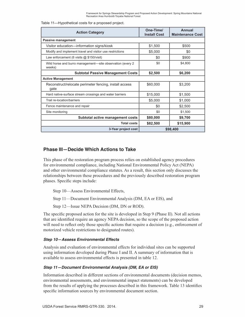
USDA Forest Service RMRS-GTR-330. 2014. 29
Framework for Springs Stewardship Program and Proposed Action Development: Spring Mountains National Recreation Area Humboldt-Toiyabe National Forest
Phase III—Decide Which Actions to Take
This phase of the restoration program process relies on established agency procedures for environmental compliance, including National Environmental Policy Act (NEPA) and other environmental compliance statutes. As a result, this section only discusses the relationships between these procedures and the previously described restoration program phases. Specific steps include:
Step 10—Assess Environmental Effects,
Step 11—Document Environmental Analysis (DM, EA or EIS), and
Step 12—Issue NEPA Decision (DM, DN or ROD).
The specific proposed action for the site is developed in Step 9 (Phase II). Not all actions that are identified require an agency NEPA decision, so the scope of the proposed action will need to reflect only those specific actions that require a decision (e.g., enforcement of motorized vehicle restrictions to designated routes).
Step 10—Assess Environmental Effects
Analysis and evaluation of environmental effects for individual sites can be supported using information developed during Phase I and II. A summary of information that is available to assess environmental effects is presented in table 12.
Step 11—Document Environmental Analysis (DM, EA or EIS)
Information described in different sections of environmental documents (decision memos, environmental assessments, and environmental impact statements) can be developed from the results of applying the processes described in this framework. Table 13 identifies specific information sources by environmental document section.
Table 11—Hypothetical costs for a proposed project.
Action CategoryOne-Time/Install Cost
Annual Maintenance Cost
Passive management
Visitor education—information signs/kiosk $1,500 $500
Modify and implement travel and visitor use restrictions $5,000 $0
Law enforcement (6 visits @ $150/visit) $0 $900
Wild horse and burro management—site observation (every 2 weeks)
$0 $4,800
Subtotal Passive Management Costs $2,500 $6,200
Active Management
Reconstruct/relocate perimeter fencing, install access gate
$60,000 $3,200
Hard native-surface stream crossings and water barriers $15,000 $1,500
Trail re-location/barriers $5,000 $1,000
Fence maintenance and repair $0 $2,500
Site monitoring $0 $1,500
Subtotal active management costs $80,000 $9,700
Total costs $82,500 $15,900
3-Year project cost $98,400

30 USDA Forest Service RMRS-GTR-330. 2014.
Framework for Springs Stewardship Program and Proposed Action Development: Spring Mountains National Recreation Area Humboldt-Toiyabe National Forest
Table 12—Sources of environmental consequence descriptions by alternative for an individual site.
Typical Project Alternatives
Applicable Phase I and II Information
No action Existing condition descriptions from Step 1 provides the basis for characterizing the consequences of taking no restoration action.
Condition ratings for individual indicators and site function are primary descriptors of these environmental consequences.
Site rehabilitation The focus of this alternative is the rehabilitation of selected condition indicators as a function of the probability of success, funding limitations, and program management emphasis.
Desired condition descriptions for site condition indicators can be used to identify environmental effects likely from implementation of proposed actions. For active management actions, short-term direct and indirect effects can be assessed based on specific project design.
Site restoration The focus of this alternative is on the restoration of all condition indicators that are currently not at desired conditions. Project cost and the probability of success are not used to limit the scope of the action.
Desired condition descriptions for specific indicators can be used to identify environmental effects likely to occur from implementation of the proposal.
For passive management actions it is important to address the rate or pace of restoration over time since natural processes are the principal mechanism.
For active management actions, short-term direct and indirect effects can be assessed based on specific project design. Address the expected rate of restoration over time because the implied purpose of management action is to accelerate the rate of change.
Table 13—Sources of information for environmental document sections.
Environmental Document Section
Information Sources
Purpose and need Derived from information developed in Step 7 (see table 8)
Environmental consequences
Derived from information from Step 10 (see table 12).
Affected environmentDerived from the GDE site condition classification conducted during Step 1 using rule sets described in appendix 1 and the resulting description of existing site conditions from Step 6.

USDA Forest Service RMRS-GTR-330. 2014. 31
Framework for Springs Stewardship Program and Proposed Action Development: Spring Mountains National Recreation Area Humboldt-Toiyabe National Forest
Step 12—Issue NEPA Decision (DM, DN, or ROD)
The final step in Phase III is to issue an agency decision, including specific project design and mitigation measures and monitoring requirements. Keep in mind that when decisions include monitoring requirements, the responsible official must assure they can be accomplished as part of the decision document.
Developing Project Monitoring Requirements
The monitoring requirements should be related to the condition indicators addressed in the decision (table 14). These attributes will be used to determine whether post-restoration conditions are moving toward or have achieved desired conditions. The attributes can include both qualitative and quantitative data and information.
Quantitative monitoring data used to detect change may be obtained using methods described in the GDE Level II Inventory Field Guide (see table 14 for specific data attributes). Use of these standard protocols allows the use of the same method for monitoring across multiple projects. Large changes can generally be detected with the methods described in Level II Inventory Field Guide; however, small changes may not be accurately discerned because of error inherent in sampling. Generic desired condition statements are provided in the center column of table 14 and are derived from the indicator condition rule sets described in Appendix 1. The generic desired condition statements described in table 8 serve as the starting point for describing desired conditions in Step 7 and in identifying potential quantitative monitoring requirements.
Qualitative monitoring information can be obtained with photos (in conjunction with notes or drawings) recorded before and after the restoration project. The GDE field guides include procedures for establishing photo points that can be used to evaluate before and after conditions at a spring/GDE feature. Implementation and monitoring audits (METI 2012) provide another example of observing implementation and the effectiveness of the project design and associated mitigation measures.
It is also important to monitor the status of physical improvements (fences, road crossings, etc.) to determine whether they were properly installed and are being maintained to original specifications.

32 USDA Forest Service RMRS-GTR-330. 2014.
Framework for Springs Stewardship Program and Proposed Action Development: Spring Mountains National Recreation Area Humboldt-Toiyabe National Forest
Table 14—Relationship of project monitoring requirements to GDE level II data attributes.
Site Condition Indicator
Generic or Typical Desired Conditions Gde Level II Data
Attributes
Physical Indicators
1. Water quality • Water chemistry is within the anticipated range of variability for the site, including suitability for the plants and animals present, or desired, at the site.
• No pollution of water is evident at the site.
- Water quality parameters
2. Water quantity • Groundwater discharge is sufficient to support riparian/wetland communities of plants and animals. In some settings this means assuring that water levels remain at or near the surface to maintain saturated soil conditions and, or, no net decomposition of peat.
• No flow regulation at the site.
• Spring flow (if expected for the site) is within the anticipated range of variability.
• Surface and groundwater flow within the watershed are not significantly altered.
- Flow rate (for springs)
- Water table depth (for wetlands)
3. Aquatic habitat • No channel incision or headcuts.
• No excessive erosion.
• No habitat destruction by animals, people or vehicles.
• Area of GDE is maintained, providing habitat for aquatic biota appropriate for the site, particularly for species of concern.
• Culverts are designed and maintained to allow aquatic organism passage.
- Extent of GDE area
4. Soils • Soils are intact and functional.
• Soils support (or have the capability to support) riparian/wetland vegetation.
• Minimal erosion, trampling, excavation, or other disturbance to the soil at the site.
• Trails have minimal impact on the site.
• Roads do not pass through the site.
• Roads adjacent to the site do not cause landform instability, sediment input or other negative effects to the site.
- Soils data—change typically takes many years
- Ground cover—particularly bare soil
Biological Indicators
5. Aquatic biota • Anticipated abundance of native aquatic biota. -- Abundance or presence of animals of interest (e.g., spring snails)
6. Fauna • Anticipated abundance of native terrestrial biota. -- Abundance or presence of animals of interest
7. Riparian/ wetland vegetation
• Anticipated cover of native riparian/wetland plant communities that are in healthy condition.
• Species indicate the presence of wetland soils and water table level appropriate for the site. No encroachment of upland vegetation.
-- Plant species abundance
-- Native species plant cover
-- Woody plant cover
-- Bryophyte abundance
-- Wetland plant abundance (e.g., prevalence index)
8. Invasive species
• Native plant and animal species dominate the site.
• Invasive species are not established at the site.
-- Cover of invasive plant species
-- Presence of invasive animals species

USDA Forest Service RMRS-GTR-330. 2014. 33
Framework for Springs Stewardship Program and Proposed Action Development: Spring Mountains National Recreation Area Humboldt-Toiyabe National Forest
Phase IV—Implement and Monitor Results
This phase of the process involves the following steps:
Step 13—Develop Implementation Guidance
Step 14—Implement Stewardship Actions
Step 15—Report Accomplishments
Step 16—Monitor Implementation and Effectiveness
Step 13—Develop Implementation Guidance
Develop contract specifications and design information or crew instructions detailing the specific actions to be taken and areas of concern that should be addressed during implementation.
Step 14—Implement Stewardship Practices
Project actions are implemented using contract, agency or partner staff, or, in the case of passive actions, the passage of time.
Step 15—Report Accomplishments
Restoration and rehabilitation accomplishments should be reported in the Watershed Classification and Assessment Tracking Tool (WCATT) database, which is used in the reporting accomplishment of essential projects and watershed improvement actions in “Step E” of the Watershed Condition Framework (USDA Forest Service 2011).
Step 16—Monitor Implementation and Effectiveness
There is often a lack of data collection on the implementation and effectiveness of restoration or rehabilitation actions (Ramstead et al. 2012). In a review of stream restoration efforts, only 10 percent of projects included monitoring data according to Bernhardt et al. (2005) and much of that monitoring did not provide information on the ecological effectiveness of the restoration actions. Therefore, it is important to monitor (a) the effectiveness of the results of restoration actions, and (b) the implementation of the restoration project to ensure the project was implemented as designed.
Implementation monitoring involves an evaluation of how well the plan was implemented (Did they do what they said they would do?). This post-project monitoring should include a review of contract or crew administration to ensure the design was implemented as planned or, if changes are made, that proper authorization for those changes are documented. An example of an implementation and effectiveness evaluation procedures is provided in the 2011 Implementation and Monitoring Audit (METI2012) that describes the implementation and effectiveness of riparian, springs, and recreation management practices in the SMNRA.
Effectiveness monitoring of the results of restoration-rehabilitation actions is intended to measure the success of the project in achieving desired conditions (Did the plan work?). Both qualitative and quantitative data are recommended for effectiveness monitoring (see Step 12). Quantitative attributes developed using methods described in the GDE Level II Inventory Field Guide can be gathered and used to evaluate changes (listed in the right column of table 14). It is important to use the same procedures or protocols for pre- and post-project conditions to provide for data consistency and change detection accuracy.
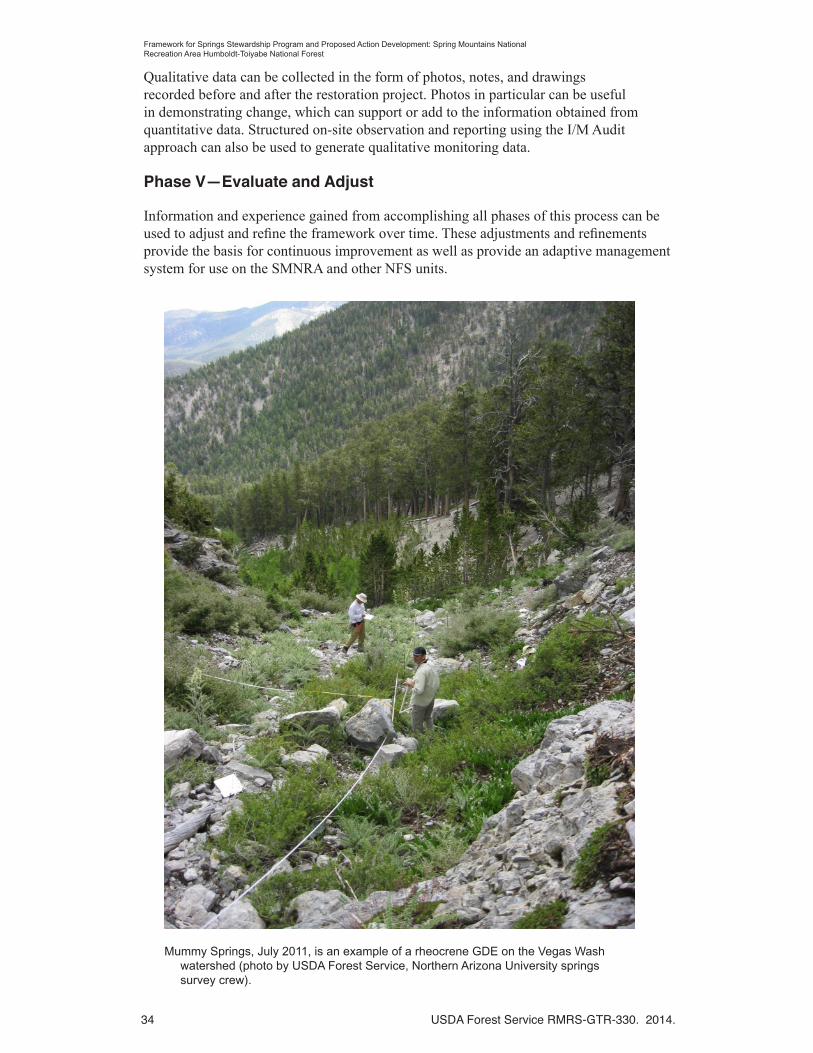
34 USDA Forest Service RMRS-GTR-330. 2014.
Framework for Springs Stewardship Program and Proposed Action Development: Spring Mountains National Recreation Area Humboldt-Toiyabe National Forest
Qualitative data can be collected in the form of photos, notes, and drawings recorded before and after the restoration project. Photos in particular can be useful in demonstrating change, which can support or add to the information obtained from quantitative data. Structured on-site observation and reporting using the I/M Audit approach can also be used to generate qualitative monitoring data.
Phase V—Evaluate and Adjust
Information and experience gained from accomplishing all phases of this process can be used to adjust and refine the framework over time. These adjustments and refinements provide the basis for continuous improvement as well as provide an adaptive management system for use on the SMNRA and other NFS units.
Mummy Springs, July 2011, is an example of a rheocrene GDE on the Vegas Wash watershed (photo by USDA Forest Service, Northern Arizona University springs survey crew).

USDA Forest Service RMRS-GTR-330. 2014. 35
Framework for Springs Stewardship Program and Proposed Action Development: Spring Mountains National Recreation Area Humboldt-Toiyabe National Forest
References
Bernhardt, E.S. [et al.]. 2005. Synthesizing U.S. river restoration efforts. Science 308 (5722): 636–637.
Black, M. 2003. Can we design ecosystems? Lessons from the California rivers. International Journal of Engineering Education 1:213–226.
Brown, J.; Wyers, A.; Aldous, A.; Bach, L. 2007. Groundwater and biodiversity conservation: a methods guide for integrating groundwater needs of ecosystems and species conservation in the Pacific Northwest. Arlington, VA: The Nature Conservancy. 51 p.
Coles-Ritchie, M.C.; Solem, S.J.; Springer, A.E.; Pendleton, B.K. [In progress]. Phase I analysis of select sites on the Spring Mountains National Recreation Area applying the framework for Springs Stewardship Program and proposed action development: Spring Mountains National Recreation Area. El Paso, TX: METI, Inc.
ENTRIX, Inc. 2008. Spring Mountains National Recreation Area landscape analysis. Unpublished report on file at: U.S. Department of Agriculture, Forest Service, Humboldt-Toiyabe National Forest, Spring Mountains National Recreation Area. Las Vegas, NV.
Lavigne, P. 2005. Humpty Dumpty and restoration policy. Natural Resources Journal 45: 495–506.
Management and Engineering Technologies International [METI], Inc. 2012. Implementation and monitoring audit report: recreation (OHV) management and springs/riparian management. El Paso, TX: METI, Inc. Unpublished report on file at: U.S. Department of Agriculture, Forest Service, Humboldt-Toiyabe National Forest, Spring Mountains National Recreation Area. Las Vegas, NV. 31 p. plus appendices.
Meine, C. 2004. Correction lines: essays on land, Leopold, and conservation. Washington, DC: Island Press.
Nevada Springs Restoration Workshop Committee. 2012. Rehabilitation and restoration of Nevada springs: A handbook. Unpublished document on file at: USDA Forest Service, Geological Resources Hazards and Surface Management, Washington, DC.
Potyondy, J.P.; Geier, T.W. 2011. Watershed condition classification technical guide. FS-978. Washington, DC: U.S. Department of Agriculture, Forest Service. 41 p.
Ramstead, K.M.; Allen, J.A.; Springer, A.E. 2012. Have wet meadow restoration projects in the southwestern U.S. been effective in restoring geomorphology, hydrology, soils, and plant species composition? Environmental Evidence 1:11.
Sada, D.W.; Pohlmann, K.F. 2006. U.S. National Park Service Mojave inventory and monitoring network spring survey protocols: level I and level II. Reno, NV: Desert Research Institute.
Society for Ecological Restoration [SER]. 2004. The SER international primer on ecological restoration. Tucson, AZ: Society for Ecological Restoration, International, Science and Policy Working Group. Online: http://www.ser.org/resources/resources-detail-view/ser-international-primer-on-ecological-restoration#3. [11 September 2013].

36 USDA Forest Service RMRS-GTR-330. 2014.
Framework for Springs Stewardship Program and Proposed Action Development: Spring Mountains National Recreation Area Humboldt-Toiyabe National Forest
Society for Ecological Restoration [SER] 2005. Guidelines for developing and managing ecological restoration projects. Washington, DC: Society for Ecological Restoration. Online: http://www.ser.org/resources/resources-detail-view/guidelines-for-developing-and-managing-ecological-restoration-projects. [16 May 2013].
Springer, A.E.; Stevens, L. 2008. Spheres of discharge of springs. Hydrogeology Journal 17:83–93.
Springer, A.E; Stevens, L.E.; Ledbetter, J.D.; Schaller, E.M.; Gill, K.; Rood, S.B. [In review]. Ecohydrology and stewardship of Alberta Springs Ecosystems. Ecohydrology.
Springs Stewardship Institute. 2013. Ecohydrology of springs on Kaibab National Forest to support forest planning. Agreement #10-CS-11030700-023. Washington, DC: U.S. Department of Agriculture, Forest Service.
Stevens, L.E.; Springer, A.E.; Ledbetter, J.D. [n.d.] SEAP: An integrated Springs Ecosystem Assessment Protocol. Online: http://www.springstewardship.org/assessment.html [23 September 2013].
USDA Forest Service. 1986. Land and resource management plan: Toiyabe National Forest. Ogden, UT: U.S. Department of Agriculture, Forest Service, Intermountain Region. 316 p. Online: http://www.fs.usda.gov/Internet/FSE_DOCUMENTS/stelprdb5143054.pdf.
USDA Forest Service. 1996. General management plan for the Spring Mountains National Recreation Area: an amendment to the land and resource management plan, Toiyabe National Forest. Ogden, UT: U.S. Department of Agriculture, Forest Service, Intermountain Region. 75 p.
USDA Forest Service. 2006. Ecosystem restoration: a framework for restoring and maintaining the national forests and grasslands. Washington, DC: U.S. Department of Agriculture, Forest Service, Restoration Framework Team. 24 p.
USDA Forest Service. 2008. Comprehensive inventory and monitoring strategy for conserving biological resources of the Spring Mountains National Recreation Area. El Paso, TX: METI, Inc.; Albuquerque, NM: U.S. Department of Agriculture, Forest Service, Rocky Mountain Research Station. 125 p.
USDA Forest Service 2011. Watershed condition framework: A framework for assessing and tracking changes to watershed condition. FS-977. Washington, DC: U.S. Department of Agriculture, Forest Service. 24 p.
USDA Forest Service. 2012a. Groundwater-dependent ecosystems: level l inventory field guide: inventory methods for assessment and planning. Gen. Tech. Report WO-86a. Washington, DC: U.S. Department of Agriculture, Forest Service. 191 p.
USDA Forest Service. 2012b. Groundwater-dependent ecosystems: level II inventory field guide: inventory methods for project design and analysis. Gen. Tech. Report WO-86b. Washington, DC: U.S. Department of Agriculture, Forest Service. 124 p.
USDA Forest Service. [In progress]. National core BMP technical guide. Vol. 1. Washington, DC: U.S. Department of Agriculture, Forest Service.
USDA Forest Service RMRS-GTR-330. 2014. 37
Framework for Springs Stewardship Program and Proposed Action Development: Spring Mountains National Recreation Area Humboldt-Toiyabe National Forest
USDI Bureau of Land Management [BLM]. 1999. Riparian area management: A user guide to assessing proper functioning condition and the supporting science for lentic areas. TR 1737-16. Denver, CO: U.S. Department of the Interior, Bureau of Land Management. 109 p.
U.S. Environmental Protection Agency [EPA]. 2011. National wetland condition assessment: field operations manual. EPA-843-R-10-001. Washington, DC: U.S. Environmental Protection Agency.
Weixelman, D.A.; Cooper, D.J. 2009. Assessing proper functioning condition for fen areas in the Sierra Nevada and Southern Cascade Ranges in California, a user guide. Gen. Tech. Rep. R5-TP-028. Vallejo, CA. U.S. Department of Agriculture, Forest Service, Pacific Southwest Region. 42 p.

38 USDA Forest Service RMRS-GTR-330. 2014.
Framework for Springs Stewardship Program and Proposed Action Development: Spring Mountains National Recreation Area Humboldt-Toiyabe National Forest

USDA Forest Service RMRS-GTR-330. 2014. 39
Framework for Springs Stewardship Program and Proposed Action Development: Spring Mountains National Recreation Area Humboldt-Toiyabe National Forest
Appendix 1—Rule Sets for Site Condition Classification
The condition classification rule sets described in this appendix are derived from the condition indicators used in the Watershed Condition Classification process as described in Step 1.
Sources of information for site condition classification include data from the Groundwater-Dependent Ecosystem (GDE) inventory gathered using the GDE Inventory Field Guides (USDA Forest Service 2012a, 2012b), ancillary information, local information and expertise, and traditional cultural knowledge (figure A.1.1).
The primary GDE inventory data used for the condition classification are the “management indicator tool” and the “disturbance” observations that were part of the GDE Level II inventory of the springs of the SMNRA. The “management indicator tool” or MIT is a series of 25 questions (answered true or false) about the effects of management or activities for the following categories: hydrology, geomorphology and soils, biology, disturbances, and administrative context. The condition rating rule sets described in the tables below list a MIT question and number as a source of information to assess site condition.
Disturbance observations acquired using the GDE Level I inventory are observations of disturbances in the following categories: hydrologic alteration, soil alteration, structures, recreational effects, animal effects, and miscellaneous. Specific disturbances from the GDE inventory are listed in many of the condition rating rule sets below (tables A.1.1-A.1.8).
The site sketch map, observer notes, and photos from the GDE Level I or II inventories can also be helpful in characterizing site conditions and identifying impairment that may need to be addressed to achieve desired conditions.
It is also advisable to look for inventory and monitoring information available from internal and external sources that could be useful in characterizing existing site conditions. Ancillary data sets common on most National Forest System (NFS) lands are identified within the rule sets when they may be useful in assessing site condition.

40 USDA Forest Service RMRS-GTR-330. 2014.
Framework for Springs Stewardship Program and Proposed Action Development: Spring Mountains National Recreation Area Humboldt-Toiyabe National Forest
Tab
le A
1.1.
Wat
er q
ualit
y co
nditi
on r
atin
g ru
le s
et.
Pu
rpo
se—
Thi
s in
dica
tor
addr
esse
s th
e ex
pres
sed
alte
ratio
n of
wat
er q
ualit
y as
soci
ated
with
phy
sica
l, bi
olog
ical
, or
chem
ical
impa
cts
to w
ater
qua
lity
asso
ciat
ed w
ith
a G
DE
site
.
Wat
er q
ual
ity
con
dit
ion
in
dic
ato
rM
inim
al t
o n
o im
pai
rmen
t to
th
e w
ater
q
ual
ity
at t
he
GD
E s
ite.
M
ino
r im
pai
rmen
t to
th
e w
ater
qu
alit
y at
th
e G
DE
sit
e.S
ign
ifica
nt
imp
airm
ent
to t
he
wat
er
qu
alit
y at
th
e G
DE
sit
e.
Att
rib
ute
sG
oo
d (
1) f
un
ctio
nin
g p
rop
erly
Fai
r (2
) fu
nct
ion
ing
at
risk
Po
or
(3)
imp
aire
d f
un
ctio
n
GD
E L
evel
I In
ven
tory
dat
a an
d in
form
atio
n
Wat
er q
ualit
y co
nditi
ons
Wat
er Q
ualit
y (M
IT #
3) is
not
ed a
s “T
rue.
”W
ater
Qua
lity
(MIT
#3)
is n
oted
as
“Fal
se.”
GD
E L
evel
I In
form
atio
n u
sed
to
co
nfi
rm o
r re
fin
e co
nd
itio
n r
atin
g
Wat
er c
hem
istr
yW
ater
che
mis
try
is w
ithin
ran
ge o
f va
riabi
lity
suita
ble
for
the
type
s of
pla
nt
and
anim
al a
ssem
blag
es p
rese
nt o
r de
sire
d at
the
site
, for
the
follo
win
g G
DE
in
vent
ory
para
met
ers;
tem
pera
ture
, pH
, sp
ecifi
c co
nduc
tanc
e, o
xida
tion-
redu
ctio
n po
tent
ial (
OR
P),
and
dis
solv
ed o
xyge
n (D
O).
Wat
er c
hem
istr
y is
not
with
in r
ange
of
varia
bilit
y su
itabl
e fo
r th
e ty
pes
of p
lant
an
d an
imal
ass
embl
ages
pre
sent
or
desi
red
at th
e si
te, f
or th
e fo
llow
ing
GD
E
inve
ntor
y pa
ram
eter
s; te
mpe
ratu
re, p
H,
spec
ific
cond
ucta
nce,
oxi
datio
n-re
duct
ion
pote
ntia
l (O
RP
), a
nd d
isso
lved
oxy
gen
(DO
).
Dis
turb
ance
s an
d P
ollu
tion
No
“pol
lutio
n” n
oted
und
er D
istu
rban
ces/
Hyd
rolo
gic
Alte
ratio
n.
No
“poi
nt s
ourc
e po
llutio
n” n
oted
und
er
Dis
turb
ance
s/ S
truc
ture
s.
“Pol
lutio
n” n
oted
und
er D
istu
rban
ces/
Hyd
rolo
gic
Alte
ratio
n.
“Poi
nt s
ourc
e po
llutio
n” n
oted
und
er
Dis
turb
ance
s/ S
truc
ture
s.
An
cilla
ry in
form
atio
n
Aba
ndon
ed o
r ac
tive
min
esA
band
oned
and
act
ive
min
es w
ithin
the
area
sho
w n
o ev
iden
ce o
f wat
er q
ualit
y co
ntam
inat
ion.
Aba
ndon
ed o
r ac
tive
min
es h
ave
docu
men
ted
evid
ence
sho
win
g so
me
adve
rse
effe
cts
to s
urfa
ce o
r gr
ound
wat
er
qual
ity w
ithin
the
area
.
Aba
ndon
ed o
r ac
tive
min
es w
ithin
the
area
ha
ve b
een
dete
rmin
ed to
be
adve
rsel
y af
fect
ing
surf
ace
or g
roun
dwat
er a
s a
resu
lt of
wat
er q
ualit
y sa
mpl
ing.
Atm
osph
eric
dep
ositi
onA
tmos
pher
ic d
epos
ition
is n
ot k
now
n to
co
ntrib
ute
to w
ater
qua
lity
conc
erns
with
in
the
area
.
Atm
osph
eric
dep
ositi
on is
kno
wn
to b
e co
ntrib
utin
g to
wat
er q
ualit
y co
ncer
ns
with
in th
e ar
ea.
Ad
dit
ion
al g
uid
ance
: N
one
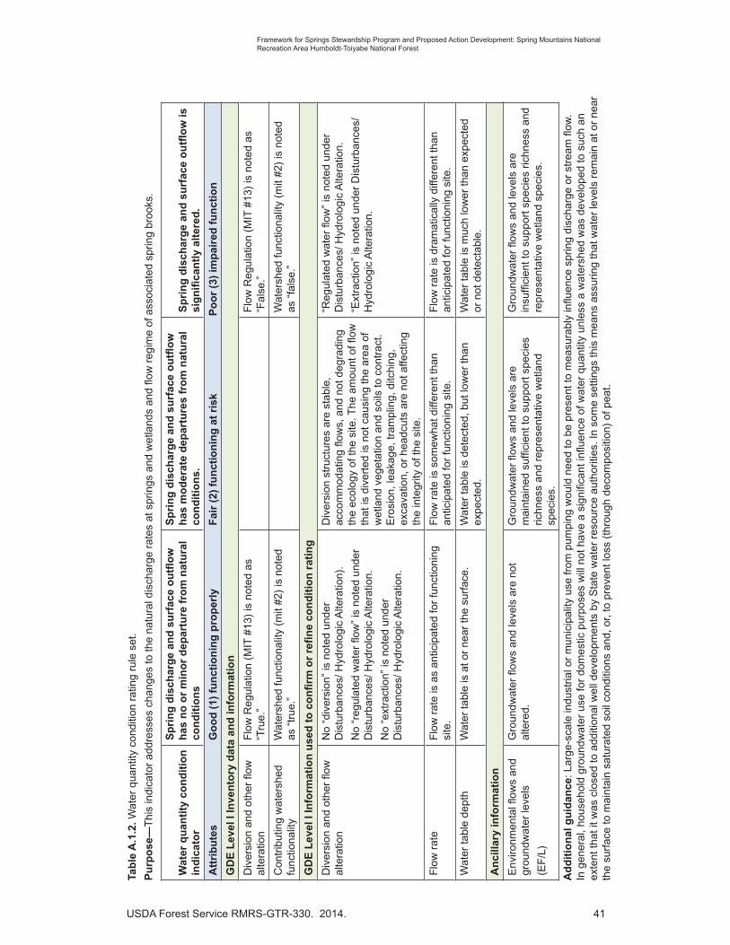
USDA Forest Service RMRS-GTR-330. 2014. 41
Framework for Springs Stewardship Program and Proposed Action Development: Spring Mountains National Recreation Area Humboldt-Toiyabe National Forest
Tab
le A
.1.2
. Wat
er q
uant
ity c
ondi
tion
ratin
g ru
le s
et.
Pu
rpo
se—
Thi
s in
dica
tor
addr
esse
s ch
ange
s to
the
natu
ral d
isch
arge
rat
es a
t spr
ings
and
wet
land
s an
d flo
w r
egim
e of
ass
ocia
ted
sprin
g br
ooks
.
Wat
er q
uan
tity
co
nd
itio
n
ind
icat
or
Sp
rin
g d
isch
arg
e an
d s
urf
ace
ou
tflo
w
has
no
or
min
or
dep
artu
re f
rom
nat
ura
l co
nd
itio
ns
Sp
rin
g d
isch
arg
e an
d s
urf
ace
ou
tflo
w
has
mo
der
ate
dep
artu
res
fro
m n
atu
ral
con
dit
ion
s.S
pri
ng
dis
char
ge
and
su
rfac
e o
utfl
ow
is
sig
nifi
can
tly
alte
red
.
Att
rib
ute
sG
oo
d (
1) f
un
ctio
nin
g p
rop
erly
Fai
r (2
) fu
nct
ion
ing
at
risk
Po
or
(3)
imp
aire
d f
un
ctio
n
GD
E L
evel
I In
ven
tory
dat
a an
d in
form
atio
n
Div
ersi
on a
nd o
ther
flow
al
tera
tion
Flo
w R
egul
atio
n (M
IT #
13)
is n
oted
as
“Tru
e.”
Flo
w R
egul
atio
n (M
IT #
13)
is n
oted
as
“Fal
se.”
Con
trib
utin
g w
ater
shed
fu
nctio
nalit
yW
ater
shed
func
tiona
lity
(mit
#2)
is n
oted
as
“tr
ue.”
Wat
ersh
ed fu
nctio
nalit
y (m
it #2
) is
not
ed
as “
fals
e.”
GD
E L
evel
I In
form
atio
n u
sed
to
co
nfi
rm o
r re
fin
e co
nd
itio
n r
atin
g
Div
ersi
on a
nd o
ther
flow
al
tera
tion
No
“div
ersi
on”
is n
oted
und
er
Dis
turb
ance
s/ H
ydro
logi
c A
ltera
tion)
.
No
“reg
ulat
ed w
ater
flow
” is
not
ed u
nder
D
istu
rban
ces/
Hyd
rolo
gic
Alte
ratio
n.
No
“ext
ract
ion”
is n
oted
und
er
Dis
turb
ance
s/ H
ydro
logi
c A
ltera
tion.
Div
ersi
on s
truc
ture
s ar
e st
able
, ac
com
mod
atin
g flo
ws,
and
not
deg
radi
ng
the
ecol
ogy
of th
e si
te. T
he a
mou
nt o
f flow
th
at is
div
erte
d is
not
cau
sing
the
area
of
wet
land
veg
etat
ion
and
soils
to c
ontr
act.
E
rosi
on, l
eaka
ge, t
ram
plin
g, d
itchi
ng,
exca
vatio
n, o
r he
adcu
ts a
re n
ot a
ffect
ing
the
inte
grity
of t
he s
ite.
“Reg
ulat
ed w
ater
flow
” is
not
ed u
nder
D
istu
rban
ces/
Hyd
rolo
gic
Alte
ratio
n.
“Ext
ract
ion”
is n
oted
und
er D
istu
rban
ces/
H
ydro
logi
c A
ltera
tion.
Flo
w r
ate
Flo
w r
ate
is a
s an
ticip
ated
for
func
tioni
ng
site
.F
low
rat
e is
som
ewha
t diff
eren
t tha
n an
ticip
ated
for
func
tioni
ng s
ite.
Flo
w r
ate
is d
ram
atic
ally
diff
eren
t tha
n an
ticip
ated
for
func
tioni
ng s
ite.
Wat
er ta
ble
dept
hW
ater
tabl
e is
at o
r ne
ar th
e su
rfac
e.W
ater
tabl
e is
det
ecte
d, b
ut lo
wer
than
ex
pect
ed.
Wat
er ta
ble
is m
uch
low
er th
an e
xpec
ted
or n
ot d
etec
tabl
e.
An
cilla
ry in
form
atio
n
Env
ironm
enta
l flow
s an
d gr
ound
wat
er le
vels
(EF
/L)
Gro
undw
ater
flow
s an
d le
vels
are
not
al
tere
d.G
roun
dwat
er fl
ows
and
leve
ls a
re
mai
ntai
ned
suffi
cien
t to
supp
ort s
peci
es
richn
ess
and
repr
esen
tativ
e w
etla
nd
spec
ies.
Gro
undw
ater
flow
s an
d le
vels
are
in
suffi
cien
t to
supp
ort s
peci
es r
ichn
ess
and
repr
esen
tativ
e w
etla
nd s
peci
es.
Ad
dit
ion
al g
uid
ance
: Lar
ge-s
cale
indu
stria
l or
mun
icip
ality
use
from
pum
ping
wou
ld n
eed
to b
e pr
esen
t to
mea
sura
bly
influ
ence
spr
ing
disc
harg
e or
str
eam
flow
. In
gen
eral
, hou
seho
ld g
roun
dwat
er u
se fo
r do
mes
tic p
urpo
ses
will
not
hav
e a
sign
ifica
nt in
fluen
ce o
f wat
er q
uant
ity u
nles
s a
wat
ersh
ed w
as d
evel
oped
to s
uch
an
exte
nt th
at it
was
clo
sed
to a
dditi
onal
wel
l dev
elop
men
ts b
y S
tate
wat
er r
esou
rce
auth
oriti
es. I
n so
me
setti
ngs
this
mea
ns a
ssur
ing
that
wat
er le
vels
rem
ain
at o
r ne
ar
the
surf
ace
to m
aint
ain
satu
rate
d so
il co
nditi
ons
and,
or,
to p
reve
nt lo
ss (
thro
ugh
deco
mpo
sitio
n) o
f pea
t.

42 USDA Forest Service RMRS-GTR-330. 2014.
Framework for Springs Stewardship Program and Proposed Action Development: Spring Mountains National Recreation Area Humboldt-Toiyabe National Forest
Tab
le A
.1.3
. Aqu
atic
hab
itat c
ondi
tion
ratin
g ru
le s
et.
Pu
rpo
se—
Thi
s in
dica
tor
addr
esse
s aq
uatic
hab
itat c
ondi
tion
with
res
pect
to h
abita
t fra
gmen
tatio
n, e
nviro
nmen
tal fl
ows
and
leve
ls, a
nd c
hann
el s
hape
and
func
tion.
Aq
uat
ic h
abit
at
con
dit
ion
ind
icat
or
Th
e G
DE
su
pp
ort
s h
igh
-qu
alit
y aq
uat
ic
hab
itat
an
d, w
her
e p
oss
ible
, hig
h-
qu
alit
y st
ream
ch
ann
el c
on
dit
ion
s.
Th
e G
DE
su
pp
ort
s so
me
hig
h-q
ual
ity
aqu
atic
hab
itat
, bu
t h
igh
-qu
alit
y st
ream
ch
ann
el c
on
dit
ion
s, if
pre
sen
t, s
ho
w
sig
ns
of
bei
ng
deg
rad
ed.
Th
e G
DE
su
pp
ort
s m
inim
al h
igh
-qu
alit
y aq
uat
ic h
abit
at, a
nd
str
eam
ch
ann
el
con
dit
ion
s, if
pre
sen
t, s
ho
w e
vid
ence
of
bei
ng
deg
rad
ed b
y d
istu
rban
ce.
Att
rib
ute
sG
oo
d (
1) f
un
ctio
nin
g p
rop
erly
Fai
r (2
) fu
nct
ion
ing
at
risk
Po
or
(3)
imp
aire
d f
un
ctio
n
GD
E L
evel
I In
ven
tory
dat
a an
d in
form
atio
n
Cha
nnel
sha
pe a
nd
func
tion
Run
out C
hann
el (
MIT
#5)
is n
oted
as
“Tru
e.”
Run
out C
hann
el (
MIT
#5)
is n
oted
as
“Fal
se.”
GD
E L
evel
I In
form
atio
n u
sed
to
co
nfi
rm o
r re
fin
e co
nd
itio
n r
atin
g
Cha
nnel
sha
pe a
nd
func
tion
No
“cha
nnel
ero
sion
” is
not
ed u
nder
Soi
l A
ltera
tion.
“Cha
nnel
ero
sion
” is
not
ed u
nder
Soi
l A
ltera
tion.
Hab
itat f
ragm
enta
tion
No
encl
osur
es, s
uch
as s
prin
g ho
use,
sp
ring
box
or c
oncr
ete
encl
osur
es a
re
note
d un
der
Str
uctu
res.
No
nega
tive
effe
cts
to a
quat
ic o
rgan
ism
pas
sage
.
May
be in
clud
e a
mid
dle
cate
gory
for
sprin
gs w
ith d
iver
sion
, but
are
man
aged
su
ch th
at s
ome
flow
is u
ndiv
erte
d an
d re
mai
ns n
ear
orifi
ce o
f spr
ing?
Enc
losu
res
such
as
sprin
g ho
use,
spr
ing
box
or c
oncr
ete
encl
osur
e ar
e no
ted
unde
r S
truc
ture
s. P
ossi
ble
nega
tive
effe
cts
to
aqua
tic o
rgan
ism
pas
sage
.
Impo
undm
ents
and
S
truc
ture
sN
o “r
egul
ated
wat
er fl
ow”
by im
poun
dmen
t/da
m”
is n
oted
und
er H
ydro
logi
c A
ltera
tion.
“Reg
ulat
ed w
ater
flow
” by
impo
undm
ent/
dam
” is
not
ed u
nder
Hyd
rolo
gic
Alte
ratio
n.
An
cilla
ry in
form
atio
n
Hyd
rolo
gyS
uffic
ient
gro
undw
ater
flow
s to
pre
vent
ch
ange
s in
trop
hic
leve
ls o
r lit
tora
l co
nditi
ons
that
wou
ld b
e de
trim
enta
l to
impo
rtan
t aqu
atic
spe
cies
or
aqua
tic li
fe
asse
mbl
ages
.
Flo
ws
prev
ent e
ncro
achm
ent o
f upl
and
or in
vasi
ve p
lant
spe
cies
and
to m
aint
ain
habi
tat f
or a
quat
ic s
peci
es o
f con
cern
.
Insu
ffici
ent g
roun
dwat
er fl
ows
to c
ause
ch
ange
s in
trop
hic
leve
ls o
r lit
tora
l co
nditi
ons
that
are
det
rimen
tal t
o im
port
ant a
quat
ic s
peci
es o
r aq
uatic
life
as
sem
blag
es.
Flo
ws
allo
w e
ncro
achm
ent o
f upl
and
or
inva
sive
pla
nt s
peci
es a
nd to
mai
ntai
n ha
bita
t for
aqu
atic
spe
cies
of c
once
rn.
Aqu
atic
hab
itat e
xten
tW
ette
d ar
ea a
nd s
prin
g br
ook
leng
th is
ad
equa
te to
mai
ntai
n bi
olog
ical
hab
itat a
nd
flow
s fo
r ba
sic
biol
ogic
al fu
nctio
n.
Wet
ted
area
and
spr
ing
broo
k le
ngth
is n
ot
adeq
uate
to m
aint
ain
biol
ogic
al h
abita
t and
flo
ws
for
basi
c bi
olog
ical
func
tion.
Ad
dit
ion
al g
uid
ance
: In
aqua
tic h
abita
ts la
ckin
g aq
uatic
bio
ta a
nd, o
r, pe
rman
ent h
abita
t (e.
g., s
ome
Sou
thw
est d
eser
t spr
ings
), e
valu
ate
cond
ition
s w
ith r
espe
ct to
w
hat w
ould
be
expe
cted
to b
e pr
esen
t und
er n
atur
al c
ondi
tions
, or
abse
nt h
uman
-indu
ced
impa
cts.

USDA Forest Service RMRS-GTR-330. 2014. 43
Framework for Springs Stewardship Program and Proposed Action Development: Spring Mountains National Recreation Area Humboldt-Toiyabe National Forest
Tab
le A
.1.4
. Soi
ls c
ondi
tion
ratin
g ru
le s
et.
Pu
rpo
se—
Thi
s in
dica
tor
addr
esse
s al
tera
tion
to n
atur
al s
oil c
ondi
tion,
incl
udin
g pr
oduc
tivity
, ero
sion
, and
che
mic
al c
onta
min
atio
n.
So
ils c
on
dit
ion
ind
icat
or
Min
or
or
no
alt
erat
ion
to
ref
eren
ce
soil
con
dit
ion
, in
clu
din
g e
rosi
on
, p
rod
uct
ivit
y, a
nd
ch
emic
al
char
acte
rist
ics
is e
vid
ent.
Mo
der
ate
amo
un
t o
f al
tera
tio
n
to r
efer
ence
so
il co
nd
itio
n is
ev
iden
t. O
vera
ll so
il d
istu
rban
ce is
ch
arac
teri
zed
as
mo
der
ate.
Sig
nifi
can
t al
tera
tio
n t
o r
efer
ence
so
il co
nd
itio
n is
evi
den
t. O
vera
ll so
il d
istu
rban
ce is
ch
arac
teri
zed
as
exte
nsi
ve.
Att
rib
ute
sG
oo
d (
1) f
un
ctio
nin
g p
rop
erly
Fai
r (2
) fu
nct
ion
ing
at
risk
Po
or
(3)
imp
aire
d f
un
ctio
n
GD
E L
evel
I in
ven
tory
dat
a an
d in
form
atio
n
Soi
l pro
duct
ivity
Soi
l Int
egrit
y (M
IT #
6) is
not
ed a
s “T
rue”
Soi
l Int
egrit
y (M
IT #
6) is
not
ed a
s “F
alse
.”
Soi
l ero
sion
Land
form
Sta
bilit
y (M
IT #
4) is
not
ed a
s “T
rue.
”
Con
stru
ctio
n an
d R
oad
Effe
cts
(MIT
#14
) is
not
ed a
s “T
rue.
”
Rec
reat
iona
l Effe
cts
(MIT
#17
) is
not
ed a
s “T
rue.
”
Land
form
Sta
bilit
y (M
IT #
4) is
not
ed a
s “F
alse
.”
Con
stru
ctio
n an
d R
oad
Effe
cts
(MIT
#14
) is
not
ed a
s “F
alse
.”
Rec
reat
iona
l Effe
cts
(MIT
#17
) is
not
ed a
s “F
alse
.”
GD
E L
evel
I in
form
atio
n u
sed
to
co
nfi
rm o
r re
fin
e co
nd
itio
n r
atin
g
Soi
l ero
sion
and
oth
er s
oil
dist
urba
nce
“Ero
sion
” un
der
Dis
turb
ance
s/ S
oil
Alte
ratio
n is
not
not
ed.
No,
or
few
, oth
er s
oil d
istu
rban
ces
unde
r D
istu
rban
ces/
Soi
l Alte
ratio
n ar
e no
ted.
“Ero
sion
” un
der
Dis
turb
ance
s/ S
oil
Alte
ratio
n is
not
ed.
Oth
er s
oil d
istu
rban
ces
unde
r D
istu
rban
ces/
Soi
l Alte
ratio
n ar
e no
ted.
An
cilla
ry in
form
atio
n
Soi
l con
tam
inat
ion
Anc
illar
y da
ta d
o no
t ind
icat
e so
il co
ntam
inat
ion
resu
lting
from
aba
ndon
ed
min
es, r
oads
, ref
use
disp
osal
, etc
.
Anc
illar
y da
ta in
dica
te s
oil c
onta
min
atio
n re
sulti
ng fr
om a
band
oned
min
es, r
oads
, re
fuse
dis
posa
l, et
c.
Atm
osph
eric
dep
ositi
onA
ncill
ary
data
do
not i
ndic
ate
atm
osph
eric
de
posi
tion.
Anc
illar
y da
ta in
dica
te a
tmos
pher
ic
depo
sitio
n.
Soi
l pro
pert
ies
Anc
illar
y da
ta d
o no
t ind
icat
e al
tera
tion
to h
ydro
logi
c cy
clin
g in
soi
l, su
ch
as c
ompa
ctio
n, d
ecre
ased
por
osity
, de
crea
sed
infil
trat
ion
capa
city
, inc
reas
ed
bulk
den
sity
, los
s of
org
anic
mat
ter,
loss
of
soi
l cov
er, l
oss
of m
icro
bial
act
ivity
, or
othe
r ap
prop
riate
indi
cato
rs.
Anc
illar
y da
ta in
dica
te a
ltera
tion
to
hydr
olog
ic c
yclin
g in
soi
l, su
ch a
s co
mpa
ctio
n, d
ecre
ased
por
osity
, de
crea
sed
infil
trat
ion
capa
city
, inc
reas
ed
bulk
den
sity
, los
s of
org
anic
mat
ter,
loss
of
soi
l cov
er, l
oss
of m
icro
bial
act
ivity
, or
othe
r ap
prop
riate
indi
cato
rs.
Ad
dit
ion
al g
uid
ance
: If a
fore
st o
r re
gion
al d
irect
ion
exis
ts fo
r so
il qu
ality
or
soil
man
agem
ent,
thes
e lo
cal t
hres
hold
s m
ay b
e us
ed to
det
erm
ine
the
appr
opria
te
ratin
g fo
r so
il at
trib
utes
. Soi
l ero
sion
sho
uld
not d
oubl
e co
unt r
oad-
rela
ted
eros
ion
effe
cts
cons
ider
ed in
the
road
s an
d tr
ails
con
ditio
n in
dica
tor.

44 USDA Forest Service RMRS-GTR-330. 2014.
Framework for Springs Stewardship Program and Proposed Action Development: Spring Mountains National Recreation Area Humboldt-Toiyabe National Forest
Tab
le A
.1.5
. Aqu
atic
bio
ta c
ondi
tion
ratin
g ru
le s
et.
Pu
rpo
se—
Thi
s in
dica
tor
addr
esse
s th
e di
strib
utio
n, s
truc
ture
, and
den
sity
of n
ativ
e an
d in
trod
uced
aqu
atic
faun
a.
Aq
uat
ic b
iota
co
nd
itio
n
ind
icat
or
All
nat
ive
aqu
atic
co
mm
un
itie
s an
d li
fe
his
tori
es a
pp
rop
riat
e to
th
e si
te a
re
pre
sen
t an
d s
elf-
mai
nta
inin
g.
So
me
nat
ive
aqu
atic
co
mm
un
itie
s an
d
life
his
tori
es a
pp
rop
riat
e to
th
e si
te a
re
pre
sen
t an
d s
elf-
mai
nta
inin
g.
Few
if a
ny
nat
ive
aqu
atic
co
mm
un
itie
s an
d li
fe h
isto
ries
ap
pro
pri
ate
to t
he
site
are
pre
sen
t an
d s
elf-
mai
nta
inin
g.
Exo
tic
and
/or
aqu
atic
inva
sive
sp
ecie
s ar
e p
erva
sive
.
Att
rib
ute
sG
oo
d (
1) f
un
ctio
nin
g p
rop
erly
Fai
r (2
) fu
nct
ion
ing
at
risk
Po
or
(3)
Imp
aire
d f
un
ctio
n
GD
E L
evel
I In
ven
tory
Dat
a an
d In
form
atio
n
Life
form
pre
senc
eF
auna
l Spe
cies
(M
IT #
10)
is n
oted
as
“Tru
e” in
term
s of
aqu
atic
bio
ta.
List
s of
aqu
atic
bio
ta o
bser
ved
indi
cate
pr
esen
ce o
f bio
ta a
ppro
pria
te to
the
site
.
Fau
nal S
peci
es (
MIT
#10
) is
not
ed a
s “F
alse
” in
term
s of
aqu
atic
bio
ta.
List
s of
aqu
atic
bio
ta o
bser
ved
indi
cate
pr
esen
ce o
f bio
ta n
ot a
ppro
pria
te to
the
site
.
Nat
ive
spec
ies
TE
S, S
OI/S
OC
, Foc
al F
auna
l Spe
cies
(M
IT #
11)
is n
oted
as
“Tru
e” in
term
s of
aq
uatic
bio
ta.
TE
S, S
OI/S
OC
, Foc
al F
auna
l Spe
cies
(M
IT #
11)
is n
oted
as
“Fal
se”
in te
rms
of
aqua
tic b
iota
.
Aqu
atic
exo
tic a
nd/o
r in
vasi
ve s
peci
esIn
vasi
ve S
peci
es (
MIT
#12
) is
not
ed a
s “T
rue”
in te
rms
of a
quat
ic b
iota
.In
vasi
ve S
peci
es (
MIT
#12
) is
not
ed a
s “F
alse
” in
term
s of
aqu
atic
bio
ta.
An
cilla
ry in
form
atio
n
Spe
cies
-spe
cific
or
proj
ect
surv
eys
Spe
cies
-spe
cific
or
proj
ect s
urve
y ob
serv
atio
ns in
dica
te p
rese
nce
of a
quat
ic
biot
a ap
prop
riate
to th
e si
te.
Spe
cies
-spe
cific
or
proj
ect s
urve
y ob
serv
atio
ns in
dica
te a
quat
ic b
iota
ap
prop
riate
to th
e si
te a
re a
bsen
t.
Ad
dit
ion
al g
uid
ance
: Avo
id fo
cus
on s
ingl
e sp
ecie
s; fo
cus
on c
omm
uniti
es. T
he p
rese
nce
of e
xotic
and
/or
aqua
tic in
vasi
ve s
peci
es is
use
d as
an
indi
cato
r of
alte
red
or im
paire
d co
nditi
ons.
Alth
ough
exo
tic a
nd/o
r aq
uatic
inva
sive
spe
cies
can
sig
nific
antly
affe
ct n
ativ
e aq
uatic
faun
al in
tegr
ity, i
ntra
-spe
cies
inte
ract
ions
are
not
co
nsid
ered
for
this
ass
essm
ent.
For
this
ass
essm
ent,
the
wid
espr
ead
pres
ence
of e
xotic
and
/or
aqua
tic in
vasi
ve s
peci
es in
dica
tes
poor
con
ditio
ns.

USDA Forest Service RMRS-GTR-330. 2014. 45
Framework for Springs Stewardship Program and Proposed Action Development: Spring Mountains National Recreation Area Humboldt-Toiyabe National Forest
Tab
le A
.1.6
. Fau
na c
ondi
tion
ratin
g ru
le s
et.
Pu
rpo
se—
Thi
s in
dica
tor
addr
esse
s th
e di
strib
utio
n, s
truc
ture
, and
den
sity
of n
ativ
e an
d in
trod
uced
terr
estr
ial f
auna
.
Fau
na
bio
ta c
on
dit
ion
in
dic
ato
r
All
nat
ive
terr
estr
ial c
om
mu
nit
ies
and
lif
e h
isto
ries
ap
pro
pri
ate
to t
he
site
are
p
rese
nt
and
sel
f-m
ain
tain
ing
.
So
me
nat
ive
terr
estr
ial c
om
mu
nit
ies
and
life
his
tori
es a
pp
rop
riat
e to
th
e si
te
are
pre
sen
t an
d s
elf-
mai
nta
inin
g.
Few
if a
ny
nat
ive
terr
estr
ial
com
mu
nit
ies
and
life
his
tori
es
app
rop
riat
e to
th
e si
te a
re p
rese
nt
and
se
lf-m
ain
tain
ing
. Exo
tic
and
, or,
aq
uat
ic
inva
sive
sp
ecie
s ar
e p
erva
sive
.
Att
rib
ute
sG
oo
d (
1) f
un
ctio
nin
g p
rop
erly
Fai
r (2
) fu
nct
ion
ing
at
risk
Po
or
(3)
Imp
aire
d f
un
ctio
n
GD
E L
evel
I In
ven
tory
dat
a an
d in
form
atio
n
Life
form
pre
senc
eF
auna
l Spe
cies
(M
IT #
10)
is n
oted
as
“Tru
e” in
term
s of
terr
estr
ial b
iota
.
List
s of
terr
estr
ial b
iota
obs
erve
d in
dica
te
pres
ence
of b
iota
app
ropr
iate
to th
e si
te.
Fau
nal S
peci
es (
MIT
#10
) is
not
ed a
s “F
alse
” in
term
s of
terr
estr
ial b
iota
.
List
s of
terr
estr
ial b
iota
obs
erve
d in
dica
te
pres
ence
of b
iota
not
app
ropr
iate
to th
e si
te.
Nat
ive
spec
ies
TE
S, S
OI/S
OC
, Foc
al F
auna
l Spe
cies
(M
IT #
11)
is n
oted
as
“Tru
e” in
term
s of
te
rres
tria
l bio
ta.
TE
S, S
OI/S
OC
, Foc
al F
auna
l Spe
cies
(M
IT #
11)
is n
oted
as
“Fal
se”
in te
rms
of
terr
estr
ial b
iota
.
An
cilla
ry in
form
atio
n
Spe
cies
-spe
cific
or
proj
ect
surv
eys
Spe
cies
-spe
cific
or
proj
ect s
urve
y ob
serv
atio
ns in
dica
te p
rese
nce
of
terr
estr
ial f
auna
app
ropr
iate
to th
e si
te.
Spe
cies
-spe
cific
or
proj
ect s
urve
y ob
serv
atio
ns in
dica
te te
rres
tria
l fau
na
appr
opria
te to
the
site
are
abs
ent.
Ad
dit
ion
al g
uid
ance
: Avo
id fo
cus
on s
ingl
e sp
ecie
s; fo
cus
on c
omm
uniti
es. T
he p
rese
nce
of e
xotic
and
, or,
terr
estr
ial i
nvas
ive
spec
ies
is u
sed
as a
n in
dica
tor
of
alte
red
or im
paire
d co
nditi
ons.
Alth
ough
exo
tic a
nd/o
r te
rres
tria
l inv
asiv
e sp
ecie
s ca
n si
gnifi
cant
ly a
ffect
faun
al in
tegr
ity, i
ntra
-spe
cies
inte
ract
ions
are
not
con
side
red
for
this
ass
essm
ent.
For
this
ass
essm
ent,
the
wid
espr
ead
pres
ence
of e
xotic
and
/or
terr
estr
ial i
nvas
ive
spec
ies
indi
cate
s po
or c
ondi
tions
.
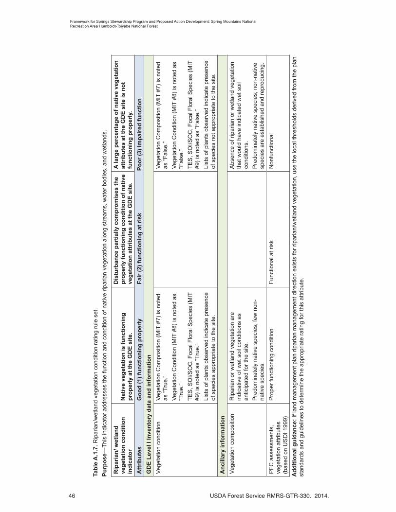
46 USDA Forest Service RMRS-GTR-330. 2014.
Framework for Springs Stewardship Program and Proposed Action Development: Spring Mountains National Recreation Area Humboldt-Toiyabe National Forest
Tab
le A
.1.7
. Rip
aria
n/w
etla
nd v
eget
atio
n co
nditi
on r
atin
g ru
le s
et.
Pu
rpo
se—
Thi
s in
dica
tor
addr
esse
s th
e fu
nctio
n an
d co
nditi
on o
f nat
ive
ripar
ian
vege
tatio
n al
ong
stre
ams,
wat
er b
odie
s, a
nd w
etla
nds.
Rip
aria
n/ w
etla
nd
ve
get
atio
n c
on
dit
ion
in
dic
ato
rN
ativ
e ve
get
atio
n is
fu
nct
ion
ing
p
rop
erly
at
the
GD
E s
ite.
Dis
turb
ance
par
tial
ly c
om
pro
mis
es t
he
pro
per
ly f
un
ctio
nin
g c
on
dit
ion
of
nat
ive
veg
etat
ion
att
rib
ute
s at
th
e G
DE
sit
e.
A la
rge
per
cen
tag
e o
f n
ativ
e ve
get
atio
n
attr
ibu
tes
at t
he
GD
E s
ite
is n
ot
fun
ctio
nin
g p
rop
erly
.
Att
rib
ute
sG
oo
d (
1) f
un
ctio
nin
g p
rop
erly
Fai
r (2
) fu
nct
ion
ing
at
risk
Po
or
(3)
imp
aire
d f
un
ctio
n
GD
E L
evel
I In
ven
tory
dat
a an
d in
form
atio
n
Veg
etat
ion
cond
ition
Veg
etat
ion
Com
posi
tion
(MIT
#7)
is n
oted
as
“T
rue.
”
Veg
etat
ion
Con
ditio
n (M
IT #
8) is
not
ed a
s “T
rue.
”
TE
S, S
OI/S
OC
, Foc
al F
lora
l Spe
cies
(M
IT
#9)
is n
oted
as
“Tru
e.”
List
s of
pla
nts
obse
rved
indi
cate
pre
senc
e of
spe
cies
app
ropr
iate
to th
e si
te.
Veg
etat
ion
Com
posi
tion
(MIT
#7)
is n
oted
as
“F
alse
.”
Veg
etat
ion
Con
ditio
n (M
IT #
8) is
not
ed a
s “F
alse
.”
TE
S, S
OI/S
OC
, Foc
al F
lora
l Spe
cies
(M
IT
#9)
is n
oted
as
“Fal
se.”
List
s of
pla
nts
obse
rved
indi
cate
pre
senc
e of
spe
cies
not
app
ropr
iate
to th
e si
te.
An
cilla
ry in
form
atio
n
Veg
etat
ion
com
posi
tion
Rip
aria
n or
wet
land
veg
etat
ion
are
indi
cativ
e of
wet
soi
l con
ditio
ns a
s an
ticip
ated
for
the
site
.
Pre
dom
inat
ely
nativ
e sp
ecie
s; fe
w n
on-
nativ
e sp
ecie
s.
Abs
ence
of r
ipar
ian
or w
etla
nd v
eget
atio
n th
at w
ould
hav
e in
dica
ted
wet
soi
l co
nditi
ons.
Pre
dom
inat
ely
nativ
e sp
ecie
s; n
on-n
ativ
e sp
ecie
s ar
e es
tabl
ishe
d an
d re
prod
ucin
g.
PF
C a
sses
smen
ts,
vege
tatio
n at
trib
utes
(b
ased
on
US
DI 1
999)
Pro
per
func
tioni
ng c
ondi
tion
Fun
ctio
nal a
t ris
kN
onfu
nctio
nal
Ad
dit
ion
al g
uid
ance
: If
land
man
agem
ent p
lan
ripar
ian
man
agem
ent d
irect
ion
exis
ts fo
r rip
aria
n/w
etla
nd v
eget
atio
n, u
se th
e lo
cal t
hres
hold
s de
rived
from
the
plan
st
anda
rds
and
guid
elin
es to
det
erm
ine
the
appr
opria
te r
atin
g fo
r th
is a
ttrib
ute.

USDA Forest Service RMRS-GTR-330. 2014. 47
Framework for Springs Stewardship Program and Proposed Action Development: Spring Mountains National Recreation Area Humboldt-Toiyabe National Forest
Tab
le A
.1.8
. Inv
asiv
e sp
ecie
s co
nditi
on r
atin
g ru
le s
et.
Pu
rpo
se—
Thi
s in
dica
tor
addr
esse
s po
tent
ial i
mpa
cts
to s
oil,
vege
tatio
n, a
nd w
ater
res
ourc
es d
ue to
inva
sive
spe
cies
(in
clud
ing
vert
ebra
tes,
inve
rteb
rate
s, a
nd
plan
ts).
8. In
vasi
ve s
pec
ies
ind
icat
or
Few
or
no
po
pu
lati
on
s o
f in
vasi
ve
spec
ies
infe
st t
he
site
th
at c
ou
ld
nec
essi
tate
rem
ova
l tre
atm
ents
th
at w
ou
ld a
ffec
t so
il an
d w
ater
re
sou
rces
.
Po
pu
lati
on
s o
f in
vasi
ve s
pec
ies
are
esta
blis
hed
wit
hin
th
e si
te a
nd
, o
r, t
he
rate
of
exp
ansi
on
an
d/o
r p
ote
nti
al f
or
imp
act
on
th
e si
te is
m
od
erat
e.
Inva
sive
sp
ecie
s p
op
ula
tio
ns
infe
st
sig
nifi
can
t p
ort
ion
s o
f th
e, a
re
exp
and
ing
th
eir
ran
ge,
an
d t
her
e is
do
cum
enta
tio
n o
f im
pac
ts t
o t
he
reso
urc
es o
f th
e si
te.
Att
rib
ute
sG
oo
d (
1) f
un
ctio
nin
g p
rop
erly
Fai
r (2
) fu
nct
ion
ing
at
risk
Po
or
(3)
imp
aire
d f
un
ctio
n
GD
E L
evel
I In
ven
tory
dat
a an
d in
form
atio
n
Ext
ent a
nd r
ate
of
spre
adIn
vasi
ve S
peci
es (
MIT
#12
) is
not
ed
as “
Tru
e.”
Inva
sive
Spe
cies
(M
IT #
12)
is n
oted
as
“Fal
se.”
GD
E L
evel
I In
form
atio
n us
ed to
con
firm
or
refin
e co
nditi
on r
atin
g
Nox
ious
and
inva
sive
sp
ecie
sN
o in
vasi
ve p
lant
s or
ani
mal
s w
ere
reco
rded
at t
he s
ite (
such
as
in th
e do
min
ant p
lant
spe
cies
list
or
othe
r ob
serv
atio
ns).
Inva
sive
pla
nts
or a
nim
als
wer
e re
cord
ed a
t the
site
(su
ch a
s in
the
dom
inan
t pla
nt s
peci
es li
st o
r ot
her
obse
rvat
ions
).
An
cilla
ry in
form
atio
n
Nox
ious
and
inva
sive
sp
ecie
sN
oxio
us w
eeds
and
or
inva
sive
sp
ecie
s ha
ve n
ot b
een
iden
tified
with
in
clos
e pr
oxim
ity to
the
GD
E s
ite b
ased
on
info
rmat
ion
in N
RM
-Ter
ra.
Nox
ious
wee
ds a
nd o
r in
vasi
ve
spec
ies
have
iden
tified
with
in c
lose
pr
oxim
ity to
the
GD
E s
ite b
ased
on
info
rmat
ion
in N
RM
-Ter
ra.
Nox
ious
wee
ds a
nd o
r in
vasi
ve
spec
ies
have
bee
n id
entifi
ed a
djac
ent
to o
r w
ithin
the
GD
E s
ite b
ased
on
info
rmat
ion
in N
RM
-Ter
ra.
Ad
dit
ion
al g
uid
ance
: T
his
indi
ctor
app
lies
only
to b
oth
aqua
tic a
nd te
rres
tria
l ver
tebr
ates
, inv
erte
brat
es, a
nd p
lant
s th
at m
ay h
ave
an a
dver
se e
ffect
on
soil
and
wat
er r
esou
rces
. In
fest
atio
n ex
tent
is u
sual
ly e
valu
ated
with
ris
k as
sess
men
ts a
nd o
ther
inve
ntor
y an
d ev
alua
tion
proc
edur
es a
t eith
er th
e sp
ecie
s le
vel,
site
leve
l, or
pro
ject
leve
l. F
or e
xam
ple,
the
exte
nt o
f the
inva
sive
spe
cies
infe
stat
ion
of a
n in
divi
dual
spe
cies
leve
l may
indi
cate
that
the
cond
ition
rat
ing
is “
good
,” b
ut w
hen
view
ed w
ithin
the
cont
ext o
f all
the
docu
men
ted
inva
sive
spe
cies
, the
ove
rall
cond
ition
rat
ing
may
be
cons
ider
ed “
poor
.”

48 USDA Forest Service RMRS-GTR-330. 2014.
Framework for Springs Stewardship Program and Proposed Action Development: Spring Mountains National Recreation Area Humboldt-Toiyabe National Forest
App
endi
x 2—
Elem
ents
Use
d to
Det
erm
ine
Rel
ativ
e Si
te S
igni
fican
ce fo
r the
SM
NR
A.
Ele
men
tsR
elat
ive
sig
nifi
can
ce r
atin
g
1—H
igh
3—M
ediu
m5—
Lo
w
Ph
ysic
al e
lem
ents
Dis
char
ge
Fo
r sp
rin
gs:
Per
enni
al fl
ow th
at is
larg
e (o
r un
usua
l) fo
r th
e ar
ea o
f int
eres
t (to
p 50
% o
f the
ra
nge
of v
alue
s; it
is a
ccep
tabl
e to
exc
lude
larg
e ou
tlier
s w
hen
dete
rmin
ing
rang
e); o
r
Fo
r g
rou
nd
wat
er-d
epen
den
t w
etla
nd
s w
ith
ou
t o
utfl
ow
ch
ann
el: E
vide
nce
of s
igni
fican
t gr
ound
wat
er d
isch
arge
, suc
h as
thic
k or
gani
c so
il de
velo
pmen
t, si
gnifi
cant
wat
er a
t sur
face
, or
wet
land
veg
etat
ion
dom
inat
es s
ite.
Fo
r sp
rin
gs:
Per
enni
al o
r se
ason
al fl
ow th
at is
m
oder
ate
for
the
area
of i
nter
est (
mid
dle
40%
of t
he
rang
e of
val
ues)
; or
Fo
r g
rou
nd
wat
er-d
epen
den
t w
etla
nd
s w
ith
ou
t o
utfl
ow
ch
ann
el: E
vide
nce
of m
oder
ate
grou
ndw
ater
dis
char
ge, s
uch
as a
sm
all a
mou
nt o
f or
gani
c so
il, th
e pr
esen
ce o
f som
e w
ater
at s
urfa
ce
and
mod
erat
e am
ount
of w
etla
nd v
eget
atio
n at
site
.
Fo
r sp
rin
gs:
Sea
sona
l (no
t per
enni
al)
flow
that
is
low
(or
com
mon
) fo
r th
e ar
ea o
f int
eres
t (bo
ttom
10
% o
f the
ran
ge o
f val
ues)
; or
Fo
r g
rou
nd
wat
er-d
epen
den
t w
etla
nd
s w
ith
ou
t o
utfl
ow
ch
ann
el: E
vide
nce
sugg
ests
sm
all a
mou
nt
of g
roun
dwat
er d
isch
arge
, suc
h as
min
imal
wat
er a
t su
rfac
e an
d m
inim
al w
etla
nd v
eget
atio
n at
site
.
Con
trib
utin
g
Aqu
ifer
Reg
iona
l – B
eyon
d th
e ex
tent
of s
urfa
ce w
ater
shed
Loca
l—W
ithin
the
surf
ace
wat
ersh
ed
GD
E fe
atur
e si
ze o
r ex
tent
Site
siz
e w
ithin
the
top
50%
of t
he r
ange
of v
alue
s w
ithin
the
area
of i
nter
est (
okay
to e
xclu
de la
rge
outli
ers
whe
n de
term
inin
g ra
nge)
.
Site
siz
e no
t with
in th
e m
iddl
e 40
% o
f the
ran
ge o
f va
lues
of t
he a
rea
of in
tere
st.
Site
siz
e w
ithin
the
botto
m 1
0% o
f the
ran
ge o
f va
lues
with
in th
e ar
ea o
f int
eres
t.
Fea
ture
type
Unu
sual
type
with
in th
e ar
ea o
f int
eres
t.S
omew
hat c
omm
on ty
pe w
ithin
the
area
of i
nter
est.
Com
mon
type
with
in th
e ar
ea o
f int
eres
t.
Isol
atio
n
Dis
tant
(gr
eate
r th
an 1
0,00
0 m
eter
s) fr
om a
noth
er
sprin
g or
sur
face
wat
er fe
atur
e (n
ot in
the
com
plex
of
gro
undw
ater
dis
char
ge fe
atur
es th
at th
e si
te is
pa
rt o
f).
Mod
erat
ely
clos
e (g
reat
er th
an 1
,000
met
ers
and
less
than
10,
000
met
ers)
to a
noth
er s
prin
g or
sur
face
wat
er fe
atur
e (n
ot in
the
com
plex
of
grou
ndw
ater
dis
char
ge fe
atur
es th
at th
e si
te is
par
t of
).
In c
lose
pro
xim
ity (
less
than
1,0
00 m
eter
s) to
an
othe
r sp
ring
or s
urfa
ce w
ater
feat
ure
(not
in th
e co
mpl
ex o
f gro
undw
ater
dis
char
ge fe
atur
es th
at th
e si
te is
par
t of)
.
Sur
face
wat
er
conn
ectiv
ity
Gro
undw
ater
dis
char
ge s
uppo
rts
or c
ontr
ibut
es
base
-flow
to a
per
enni
al s
trea
m.
Gro
undw
ater
dis
char
ge s
uppo
rts
a st
ream
that
di
sapp
ears
afte
r a
shor
t to
mod
erat
e di
stan
ce.
Gro
undw
ater
dis
char
ge d
oes
not s
uppo
rt a
n ou
tflow
st
ream
.
Bio
log
ical
ele
men
ts
TE
S a
nd fo
cal s
peci
esT
hrea
tene
d, e
ndan
gere
d, s
ensi
tive
or fo
cal s
peci
es
pres
ent.
Thr
eate
ned,
end
ange
red,
sen
sitiv
e or
foca
l spe
cies
ex
pect
ed b
ut n
ot fo
und
(req
uire
s un
ders
tand
ing
of
site
s an
d lo
cal s
prin
g an
d w
etla
nd e
colo
gy).
Thr
eate
ned,
end
ange
red,
sen
sitiv
e or
foca
l spe
cies
no
t exp
ecte
d an
d no
t fou
nd (
requ
ires
unde
rsta
ndin
g of
site
s an
d lo
cal s
prin
g an
d w
etla
nd e
colo
gy).
Veg
etat
ion
type
Unu
sual
wet
land
veg
etat
ion
type
with
in th
e ar
ea o
f in
tere
st.
Som
ewha
t com
mon
wet
land
veg
etat
ion
type
with
in
the
area
of i
nter
est.
Com
mon
wet
land
veg
etat
ion
type
with
in th
e ar
ea o
f in
tere
st, o
r no
wet
land
veg
etat
ion
pres
ent.
Inva
sive
or
noxi
ous
spec
ies
Inva
sive
or
noxi
ous
plan
t or
anim
al s
peci
es a
bsen
t.
Use
list
s m
aint
aine
d by
reg
ions
or
stat
es.
Inva
sive
or
noxi
ous
plan
t or
anim
al s
peci
es a
t ver
y lo
w a
bund
ance
. U
se li
sts
mai
ntai
ned
by r
egio
ns o
r st
ates
.
Inva
sive
or
noxi
ous
plan
ts o
r an
imal
spe
cies
es
tabl
ishe
d at
the
site
. U
se li
sts
mai
ntai
ned
by
regi
ons
or s
tate
s.
So
cial
/Cu
ltu
ral/E
con
om
ic e
lem
ents
Cul
tura
l sig
nific
ance
Det
erm
ined
in c
onsu
ltatio
n w
ith c
ultu
ral r
esou
rce
spec
ialis
t.
No
te:
See
tabl
e 2
for
desc
riptio
ns a
nd d
efini
tions
of s
igni
fican
ce e
lem
ents
.

USDA Forest Service RMRS-GTR-330. 2014. 49
Framework for Springs Stewardship Program and Proposed Action Development: Spring Mountains National Recreation Area Humboldt-Toiyabe National Forest
Appendix 3—SMNRA Springs/Riparian Management Response Framework
As a result of the 2011 SMNRA Implementation and Monitoring Audit (I/M Audit) of springs and riparian management practices a “management response framework” was developed (METI2012). The management response framework uses a combination of (1) land management plan and the SMNRA General Management Plan objectives, standards and guidelines and (2) audit team evaluation of management practice effectiveness to determine “best practices” applicable within the SMNRA.
The I/M Audits are designed and conducted to strengthen organizational learning and provide for continuous improvement. They consist of a structured evaluation of management actions, bringing together inventory information, desired conditions from the Forest Plan, project planning, and completed implementation. Documentation and on-site project review focuses on two areas: Implementation monitoring and effectiveness monitoring.
Implementation monitoring: “Did we do what we said we would do?” If changes were made at any point, were the changes appropriately documented? Included in this step is an evaluation of the planning documents for completeness and relevance, as well as an evaluation of the translation of the planning documents to the implementation direction. Over the long term, implementation monitoring helps us evaluate whether there are patterns to changes in implementation, which would indicate a need to make systemic changes in planning procedures or documents.
Effectiveness monitoring: “Do the results reflect our desired outcomes?” What parts of the action worked? What parts need modification for the next project?
I/M Audits address questions that are best evaluated by using both qualitative and quantitative methods. The Fiscal Year (FY) 2011 I/M Audit focused on: management of riparian and spring areas, and management of motorized recreation with a focus on off-highway vehicle (OHV) management. To audit the implementation and effectiveness of these management activities, the following monitoring questions (MQ) identified in the SMNRA Inventory and Monitoring Strategy were addressed:
• How effective are efforts to reduce recreation effects to riparian and spring areas? (MQ 8)
• How effective is riparian fencing in protecting springs and riparian areas? What thresholds warrant this level of mitigation? (MQ 51)
• How effective are efforts to manage motorized recreation (OHV) and limit other uses (outfitters and guides) to the protection and conservation of SOC/SOI and their habitats? (MQ 5)
This round of IM Audits was conducted on projects selected by the Deputy Forest Supervisor during a 3-day workshop held October 25-27, 2011. Participants included the line and staff personnel involved in the management of recreation activities and riparian and spring areas. Five projects were selected, representing a variety of conditions and management activities, and included: West Mud Springs, Cold Creek, Willow Spring, Carpenter Canyon, and Mountain Springs area adjacent to the Rainbow Mountain Wilderness.

50 USDA Forest Service RMRS-GTR-330. 2014.
Framework for Springs Stewardship Program and Proposed Action Development: Spring Mountains National Recreation Area Humboldt-Toiyabe National Forest
West Mud Springs, July 2011; this photo documents several types of disturbances (photo by USDA Forest Service, Northern Arizona University springs survey crew).
Willow Spring, October 2011, covers 462 square meters and is on the Sand Spring-Tikaboo Valleys watershed (photo by Larry Timchak, METI, Inc.).

USDA Forest Service RMRS-GTR-330. 2014. 51
Framework for Springs Stewardship Program and Proposed Action Development: Spring Mountains National Recreation Area Humboldt-Toiyabe National Forest
Willow Spring, October 2012, covers 462 square meters and is on the Sand Spring-Tvikaboo Valleys watershed (photo by USDA Forest Service, Northern Arizona University springs survey crew).
Concepts and Factors Used in Developing the SMNRA Springs/Riparian Management Response Framework
Given the importance of water—springs, streams, and riparian areas—to the SMNRA, it is no surprise that these areas have been used by wildlife, livestock, and people for a long time; they provide habitat for endemic plant and animal communities. Many show the wear and tear that results from long-term use and the remnants of past management activities, including watering devices, diversions, and structures.
A key factor in determining when and how to establish riparian exclosure fences is the ecological significance of the spring/riparian area. Ecological significance is determined by a combination of factors and can be determined by using the information and data being collected in the springs inventory program. Preliminary discussions indicate that the following elements should contribute to the determination of ecological significance:
• Spring type
• Riparian area/feature size
• Surface flow
• Vegetation community
• Presence of Conservation Agreement (CA) species
The potential for disturbance or damage by wild horses/burros, elk, and recreation use are other factors to be considered. In some instances, drift fences established in lower portions of canyons are more effective alternatives to reducing potential effects from wild horses/burros and should be considered before fencing individual sites.

52 USDA Forest Service RMRS-GTR-330. 2014.
Framework for Springs Stewardship Program and Proposed Action Development: Spring Mountains National Recreation Area Humboldt-Toiyabe National Forest
Elk use effects at springs are related to the distribution of the elk population across the SMNRA. Fences that effectively exclude elk are expensive to build and maintain. Use of external water sources is likely more effective in reducing use by elk than more elaborate fencing designs.
Recreation use effects can often be effectively managed by a combination of restricting use by physical barriers and designation of access routes and interpretive signing/visitor education.
Forest Plan standards and guidelines provide a starting point for developing a framework for managing recreation use at springs and in riparian areas. They also provide guidance for determining when fencing should be used to protect CA species and their habitats, as well as exclosure design. The following HTNF Forest Plan/GMP standards apply design elements included in this framework (numbers in parentheses refer to sections of the HTNF Forest plan, and Letters and numbers at the beginning of the bullet refer to the GMP):
• If a riparian area within a wild horse and burro territory is fenced, pipe water out of riparian areas for wild horse and burro use. (0.2)
• When developing water sources, pipe water from a point downstream of the source if snails or other sensitive species are present, or if the spring source has not been previously developed. (0.8)
• Remove existing water developments and debris from springs, providing they no longer serve their original purpose, are not critical to wildlife, and the items are not of historical significance. (0.13)
• Prohibit parking and camping within riparian areas. (0.2)
• MA 11—Provide protection of the riparian areas (in accordance with Nevada Revised Statute 503.660) at Cold and Willow Creeks through the use of new road alignments, vehicle barriers, and, or, signage. Redirect parking and camping away from riparian corridors. Allow only day-use, walk-in activities to occur within the riparian corridor. (11.1)
• MA 13—Develop low standard recreation facilities, including small campsites or restrooms, in Carpenter Canyon as a resource protection measure. Close the last section of road to prevent vehicle access through stream and riparian area. Make campsites walk-in access only. (13.17)
The following decision framework (table A.3.1) is recommended to determine proposed actions associated with springs/riparian management designed to reduce the effects of uses and disturbance on springs and riparian areas.

USDA Forest Service RMRS-GTR-330. 2014. 53
Framework for Springs Stewardship Program and Proposed Action Development: Spring Mountains National Recreation Area Humboldt-Toiyabe National Forest
Table A.3.1. Springs/riparian management framework.
Common Design Features
• Drift Fences—Evaluate opportunities to establish drift fences to control access to springs by wild horses/burros before proposing fencing at individual sites.
• Perimeter—Consider fencing areas larger than the spring riparian area to provide better anchor points and screening. At a minimum, exclosure fences and management efforts should approximate the perimeter of the spring riparian area. Slope breaks and vegetation should be the primary factors used to determine the perimeter and location of fences and delimiting areas of use.
• Existing Developments—Remove existing water developments and debris from springs, providing they no longer serve their original purpose, are not critical to wildlife, and the items are not of cultural significance. Restore and revegetate areas associated with these improvements.
• Maintenance and Monitoring—Adhere to maintenance schedules established for each fencing design and associated monitoring schedules and focus.
High ecological significance
wild horses & burros present/elk use
high – moderate recreation use
High ecological significance
no wild horses & burros/elk use
high – moderate recreation use
• Establish and maintain a post/wire rope exclosure
• Exclude all wild horses and burros
• Do not allow elk access
• Provide external water source(s)
• Restrict and manage recreation use/access using physical barriers/trail locations
• Provide interpretive and recreation signing
• Restrict and manage recreation use/access using physical barriers/trail locations
• Interpretive and recreation signing
Moderate ecological significance
wild horses & burros present/elk use
moderate – low recreation use
Moderate ecological significance
no wild horses & burros/elk
moderate – low recreation use
• Establish and maintain a t-post/barbed wire exclosure
• Provide external water source
• Restrict and manage recreation use/access using physical barriers/trail locations
• Provide interpretive and recreation signing
• Restrict and manage recreation use/access using physical barriers/trail locations
• Provide interpretive signing
Low ecological significance
wild horses & burros present
low recreation use
Low ecological significance
no wild horses & burros/elk
low recreation use
• No exclosure fence warranted. Site-specific exceptions may occur
• Provide interpretive signing
• No exclosure fence warranted
• No interpretive or recreation signing
54 USDA Forest Service RMRS-GTR-330. 2014.
Framework for Springs Stewardship Program and Proposed Action Development: Spring Mountains National Recreation Area Humboldt-Toiyabe National Forest
Appendix 4—Nevada Springs Restoration Practices
This appendix is based on information developed by the Nevada Springs Restoration Workshop Committee (2012), as well as text written by Joe Gurrieri, Forest Service hydrogeologist and member of that Committee. The specific text from the Nevada Springs Restoration Workshop Committee was derived from Module 4 “Springs Restoration and Spring Source Water Management” authored by Rob Andress, Kathryn Boyer, R.J. Johnson, and Abraham E. Springer.
Although a large amount of general planning and implementation guidance is available for ecological restoration, a comprehensive summary of groundwater-dependent ecosystem (GDE) restoration projects has not been prepared nor have guidance documents, manuals, or methods specific to GDE restoration been published. Stacey et al. (2011) evaluated the success of several restoration efforts. The Society for Ecological Restoration (2004, 2005) provides relevant guidance regarding general planning and implementation guidelines on the practice of ecological restoration. Abela (2011) and Sada et al. (2001) are general publications on springs conservation in the West. Wetland restoration, enhancement, and creation are covered in a handbook by the USDA Natural Resources Conservation Service (2008). Biebighauser (2011) presents wetland restoration and construction from an eastern United States perspective. The Groundwater-Dependent Ecosystems: Level I and II Inventory Field Guides (USDA Forest Service 2012a, 2012b, respectively) are assessment protocols developed specifically for GDEs and can aid in the restoration planning process. Other inventory and assessment protocols for springs have been developed by Sada and Pohlman (2002, 2006), Brown et al. (2007) and by the Springs Stewardship Institute (Stevens et al. n.d.).
Invasive aquatic species, if present, may be the single most important consideration in restoration planning and design. The presence of invasive species can have a considerable effect on a restoration project to the degree that certain concessions must be made to achieve complete restoration of pristine or pre-disturbance physical and biological conditions. For example, if the spring discharge is not sufficient to sustain open channel flow for great distances, pre-disturbance conditions may have been characterized by a shallow marsh immediately downstream from the spring source. However, given the presence of crayfish (assuming eradication is not possible) it may be necessary to design the restoration such that an open channel will be maintained for the maximum extent of distance and time to reduce the amount of habitat most suitable for the invasive species.
Invasive species eradication may be the first step of a restoration project, but may also require substantial modification of habitat prior to restoration. For example, an attempt to eradicate crayfish may require complete diversion and desiccation of the spring source and outflow. The merit of this approach must be weighed on a project-by-project basis and the feasibility of complete eradication must be carefully assessed against the potential risks of such an effort (such as species loss). If native species remain in the system they must be salvaged prior to such an effort. Such an effort can greatly increase project cost and duration as it may require more than one year and multiple desiccation events or modifications of approach to achieve the eradication. The eradication of invasive fish species may require application of a pesticide prior to restoration and may also require native species salvage.

USDA Forest Service RMRS-GTR-330. 2014. 55
Framework for Springs Stewardship Program and Proposed Action Development: Spring Mountains National Recreation Area Humboldt-Toiyabe National Forest
Passive Restoration
There are three types of passive restoration management actions: (1) protection of natural sites, (2) eliminating identified stressors to reduce impairment, and (3) management actions to prevent or alleviate potential, future threats. Common stressors impacting GDEs include groundwater extraction, impacts to groundwater quality, livestock grazing, surface water diversion, invasive species, or recreation impacts. Examples of management actions for the prevention or elimination of stressors are provided below.
Groundwater Extraction
Impacts due to groundwater extraction may include decreased or cessation of spring flow, reduction in overall wetland and aquatic habitat area, or changes in plant and animal composition. Methods to eliminating stressors related to groundwater extraction could include a management strategy to reduce impacts to spring source discharge by varying the pumping schedule or pumping location.
Impacts to Groundwater Quality
Impacts to groundwater quality could be due to nearby industrial or agricultural activities. Stagnation or eutrophication may also result in diminished water quality. Management strategies for stagnation could include improving nutrient flushing and removal by eliminating outflow blockage and improving source and outflow area flushing. Groundwater quality may also be impacted by the presence of livestock at the spring source and within the outflow habitat. Reducing impacts to groundwater quality may require the closure of the spring and outflow to livestock access. Management strategies could include monitored natural attenuation, removal of pollution source, and pollution source control and isolation.
Livestock Grazing
Changes in the duration, season, or intensity of grazing may be sufficient to eliminate impacts at a given site. In certain instances, it may also be necessary to
• Provide off-site watering away from GDEs to ensure they are protected;
• Install or repair float valves on water troughs to ensure flow does not run when not needed;.
• Construct or repair exclosure fences around spring/seep sources;
• Trail livestock away, rather than through, GDEs; or
• Discontinue use of water resources in critical GDEs.
Surface Water Diversion
Diversion of surface water may result in decreased flow to a GDE or outflow stream. Impacts due to surface water diversion could include loss of overall wetland or aquatic habitat or area, and changes in plant and animal species composition. Management strategies to reduce impacts due to surface water diversion include changing the location of the diversion, reducing the quantity of water diverted, or allowing an increased amount of flow to discharge to the spring outflow habitat.
Invasive Species
Impacts due to invasive species may include changes in native plant and animal species composition, reduction or extirpation of native plant and animal species, or changes in
56 USDA Forest Service RMRS-GTR-330. 2014.
Framework for Springs Stewardship Program and Proposed Action Development: Spring Mountains National Recreation Area Humboldt-Toiyabe National Forest
plant community composition and structure. Invasive species removal could include the mechanical removal of invasive plants, trapping of invasive animal species, or the application of herbicide and pesticide. In wetlands, raising the water table by filling ditches may decrease the competitive advantage of some invasive plants and favor native wetland species.
Recreation Impacts
Restoration of springs from recreational activities is generally similar to those for grazing impacts. Impacts due to recreation may include site trampling, soil compaction, surface water diversion, and accumulation of refuse. Reducing impacts due to recreation may range from complete site closure to building trails and boardwalks, and elimination of onsite camping and vehicular access.
Active Restoration
In general, the primary approach to active restoration of GDEs is the reshaping, reconstructing, or rehabilitation of the spring source and outflow channel or wetland. Most restoration designs are based on moderately to well-informed assumptions and species habitat requirement data. Undisturbed reference sites are rarely discovered but inferences can be made based on habitat requirements and preferences by target species, hydrology, geomorphology, historical documents and photographs, and occasionally paleoecology. Most restoration projects are initiated due to a decline in a single species or group of target species and focus on the reconstruction or rehabilitation of “pre-disturbance” physical conditions with the assumption that reconstructing or rehabilitating the physical conditions will result in improved biological conditions, species recovery and species preservation.
The specific actions required for restoration may range from the removal of manmade infrastructure such as spring boxes, tanks and piping to complete physical manipulation, and reconstruction of site conditions. Where natural topography, drainage, and geomorphology is determined to be largely intact and physical conditions will allow the desired conditions to be achieved, it may only be necessary to remove or modify infrastructure in a way that alleviates impacts and stressors. Complete physical reconstruction is typically required at sites where all pre-disturbance topography and natural drainage has been obliterated by site development and modification.
The overall approach to restoration will differ due to the GDE type, such as limnocrenes (pool-forming springs), rheocrenes (forming or discharging in distinct channels), and helocrenes (wetlands). It is necessary to recognize that the desired condition should match the GDE type and characteristics of the pre-disturbance condition as closely as possible. The site assessment should determine the overall feasibility of achieving the pre-disturbance spring condition based on the degree of physical alteration and impact at any given site. Careful consideration should be given to the expected trajectory of recovery for both biological and physical factors and processes when selecting the desired conditions and restoration design/strategy. Example approaches to the restoration of each type of spring are discussed below.
For the purpose of restoration planning, GDEs are divided into those that have water flowing in channels and those that do not. For GDEs that do not have flowing water in channels, groundwater level is the driver of ecological health. Springs that have water flowing in channels can be evaluated in a similar way to streams. However, a few differences exist in the geomorphic, biologic, and flow regime of spring channels that

USDA Forest Service RMRS-GTR-330. 2014. 57
Framework for Springs Stewardship Program and Proposed Action Development: Spring Mountains National Recreation Area Humboldt-Toiyabe National Forest
differentiates them from streams. The low variability in the hydroperiod in springs results in habitats with specific community composition and relatively static spatial extent. This differs from streams, where the stream flow energy is essential for the maintenance of geomorphic and riparian processes and where the ecosystem is more dynamic.
Limnocrene
Pool-forming (limnocrene) springs are influenced by groundwater pumping, and may be subjected to stagnation, eutrophication, and deoxygenation changes that reduce habitat quality and functionality. Restoration challenges for limnocrenes may involve recreating natural water quality and desired pool area and pool habitat. Where a limnocrene spring has been over excavated in the past, it may be determined that a reduction in pool diameter similar to that of its pre-disturbance dimensions is preferable for improving habitat for target species or eliminating habitat for invasive species such as shallow margins where cattail, bullfrog, and crayfish may be prevalent. Without historical documentation (historical descriptions or photographs), it is difficult to determine the pre-disturbance pool size. However, it may be possible to use other limnocrene springs as an analog if the springs are relatively undisturbed, occur in similar substrate, and exhibit similar discharge. Similarly, springs of unequal discharge but occurring in similar substrate can be used to scale to the desired discharge. Be aware that many springs appear as limnocrenes today because they have been excavated to create a pool for watering of livestock or wildlife. Limnocrenes are more common on flat valley floors and rare in steeper mountainous terrain.
Rheocrene
A rheocrene is a spring where discharge emerges into a defined channel. Rheocrenes and associated spring brooks are often important for springs-specialist plants and animals. Modification of flow regulation structures (e.g., dams, diversions, spring boxes) may be necessary to restore the flow at the source and to restore the functionality of downstream spring brooks or wetlands. For example, installing a flow splitter, shifting the point of diversion downstream from the source, removing a dam, or modifying a spring box and pipes may help ensure flow at the spring’s source, with the amount of diverted flow to be evaluated based on goals for the site.
Restoration of rheocrene springs can range from streambank stabilization to complete channel reconstruction. In circumstances where spring flow has been diverted from the historical channel, and the historic channel has not been obliterated, it may be possible to return flows to the historical channel. Where the historic outflow channel has been obliterated, it is necessary to reconstruct the stream channel by excavating or constructing a new channel. Selection of the appropriate channel dimension and morphology (width, depth, slope, sinuosity, substrate, single or multiple thread channel, etc.) is largely dependent on an analysis of drainage basin hydrology, historic channel form, habitat requirements of target species, and desired conditions.
The flow variability of springs is generally much smaller than streams making concepts such as channel geomorphology, bankfull flows, overbank flows, and sediment transport relatively less important in restoration. The dampened hydrograph and limited sediment input characteristics of springs leads to the formation of channels with steep, well-vegetated banks; armored beds; higher sinuosity values; and lower width-to-depth values (Griffiths et al. 2008). Springs with channelized flow can be divided into runoff-dominated springs that are located in perennial or intermittent channels and undergo periodic scouring, and spring-dominated channels that are on uplands and are never

58 USDA Forest Service RMRS-GTR-330. 2014.
Framework for Springs Stewardship Program and Proposed Action Development: Spring Mountains National Recreation Area Humboldt-Toiyabe National Forest
scoured by flood flows. The disturbance regime has a large effect on the types of biota that inhabit the spring ecosystem. Discharge regime and sediment input are the major differences in controls on channel morphology that are found between spring-dominated and runoff-dominated channels.
Runoff-dominated springs are characterized by frequent flood events and considerable inter-annual flux in vegetation cover and diversity. Frequent scouring is a natural stressor that decreases species richness of aquatic communities. These springs therefore have lower resource value and recovery potential. Moderate to high variability in the size and spatial arrangement of vegetation patches or aquatic invertebrate composition in such settings is a normal system attribute; resilience to disturbance may be the only useable metric of ecosystem health other than wetted area or flow. Flow regulation may stabilize normally highly disturbed streamside spring ecosystems altering structural, functional, and trophic characteristics of springs. Spring-dominated channels are highly stable environments characterized by dampened hydrographs, and low erosion, sediment, and disturbance rates.
Helocrene
Wetland, wet meadows, cienegas or fen habitats (helocrene) are characterized by diffuse flow across shallow-gradient landscapes. The feasibility of restoring helocrene springs depends largely on existing site conditions and degree of alteration. Restoration of such habitats often involves filling in ditches, preventing erosional head-cutting with grade control structures, eliminating erosional channels, removing drainage tiles or subgrade water diversion structures to decrease groundwater depth, and replanting native wetland plant species. The goal of fen restoration is often to regenerate peat formation by recreating conditions that characterize an undisturbed fen. Where surface water diversion or ditching has reduced the overall wetland habitat area or lowered the water table, but the natural topography of the wetland remains, it may be sufficient to return flow to the original wetland area or raise the water table. However, where the original topography and wetland has been eliminated in its entirety it may be necessary to recreate the topography necessary to allow the development and recovery of wetland habitat.
All efforts should be made to recreate topography that will sustain wetland types and characteristics that would have been present prior to alteration of the site. A thorough analysis of drainage basin hydrology, analog wetland sites, and feasibility of achieving desired conditions should be made prior to selecting the final restoration design and strategy. For example, the feasibility of restoring a fen requires that suitable conditions are created for the development of a permanently saturated peat layer. If it is not possible to create the necessary site conditions for sustaining the desired condition, an alternative approach or restoration strategy should be considered.
The most important parameters to which helocrenes and dependent species respond are: (1) maintenance of a water table level within a natural range of variation (generally at or near the surface, which generates peat accumulation), (2) groundwater flux to the feature, (3) upward head gradients in the aquifer, and (4) water quality.
Spring Source Water Management
Guidance Documents on Spring Source Water Development
The Natural Resources Conservation Service has a number of handbooks that present information and engineering designs for source water development at springs (USDA

USDA Forest Service RMRS-GTR-330. 2014. 59
Framework for Springs Stewardship Program and Proposed Action Development: Spring Mountains National Recreation Area Humboldt-Toiyabe National Forest
NRCS, 2006, 2010, 2011). These references, however, do not focus on conservation or restoration of spring habitats and use of the designs could result in ecosystem damage if conservation measures are not taken into account during the design phase.
Forest Service revised Best Management Practices (BMPs) that apply to National Forest System lands, as documented in the Soil and Water Conservation Practices Handbook, are currently under development (USDA Forest Service 2012c). At the time of publication, these practices had undergone internal review, but the formal process for adoption through the Administrative Procedures Act, including notification in the Federal Register and establishment of a public comment period on the draft BMPs, had not been initiated.
Environmental Flows and Levels Analysis
An environmental flows and levels analysis should be undertaken whenever a spring or spring-fed wetland is to be developed, redeveloped, restored or is to undergo maintenance of diversion or collection facilities. Determining quantitative environmental flows and levels (EF/L) for groundwater is critical for ensuring adequate water to sustain GDEs in cases where management activities, such as mining, wells for municipal water supply, and water withdrawals for livestock operations, affect groundwater flow to GDEs. EF/L for groundwater takes into account the ability of the site to adjust to changes in the water regime. Therefore, EF/L allows for an acceptable level of change to occur relative to the existing hydrologic conditions. When use of water resources shifts the hydrologic conditions below that defined by the EF/L, irreversible ecological harm may occur, including impairment or loss of ecological structure and function.
GDEs, by definition, are supported by aquifers. Any activity that lowers or raises the water table, piezometric surface, or groundwater discharge rate or timing, or alters the groundwater chemistry can affect the integrity of aquatic habitat. An EF/L establishes the limit to water level change for an aquifer or water body. It is the limit at which further withdrawals or flooding would be significantly harmful to the site. The establishment of an EF/L for a discharge wetland or phreatophyte community generally defines a limit on water-table drawdown or increase, or a reduction in discharge feeding the feature from the aquifer. If monitoring indicates the actual water levels or flows are below the defined EF/L, a recovery plan can be developed to reach acceptable levels. A strategy for developing EF/Ls for groundwater-dependent wetlands will be presented in the forthcoming USDA Forest Service, Groundwater Inventory, Monitoring, and Assessment Technical Guide (in development).
Approaches to Spring Source Water Development
Flow regulation structures at springs and wetlands are designed to capture and divert water for uses such as livestock watering, domestic use, or irrigation. Water developments are more common at springs than wetlands. Forms of spring flow alteration include diversion from the pre-orifice (prior to the point of emergence) or post-orifice (after emergence) environment. Pre-source diversion is often achieved by (1) sealing the springs orifice from bedrock (and sometimes sealing the surrounding bedrock fractures) and installing piping, or (2) excavating the springs source, installing a slotted pipe catchment system, back-filling the excavation, and piping the water. Post-orifice diversion is also common, particularly for livestock watering and development of ponds. Spring flows are commonly captured into open troughs or into covered tanks and then piped to troughs or ponds. These alterations may preserve some ecological function at the spring’s source, but often eliminate spring channel and wetland functions. The most common types of spring source development are:

60 USDA Forest Service RMRS-GTR-330. 2014.
Framework for Springs Stewardship Program and Proposed Action Development: Spring Mountains National Recreation Area Humboldt-Toiyabe National Forest
• Complete diversion;
• Spring source excavation;
• Fencing and offsite watering;
• Spring source capture, gravel trench, perforated pipe, tank, spring box;
• Spring source capture, drilling, piping, tank, spring box;
• Flow splitting;
• Float valve filling and discharge to natural outflow; and
• Spring source enclosure and offsite watering.
Extraction of groundwater from the aquifer may partially or wholly dewater individual springs or entire complexes of springs resulting in fragmentation of habitat, increasing isolation of springs ecosystems, and interruption of biogeographic processes. Groundwater augmentation may occur when aquifers are artificially recharged by urban runoff, when reservoirs, ditches, or irrigation increase water tables, or through climate changes that increase precipitation. Increased springs flow is often accompanied by a change in flow chemistry and pollutants.
Diversions that remove very small amounts of water may minimally affect biota. Activities that occur infrequently and involve small disturbances may also minimally affect biota if sufficient time passes for the site to naturalize after each disturbance (it may take decades to naturalize after these types of disturbances). In general, species richness declines as diversion increases, and there are functional shifts in the structure of aquatic and riparian communities. Modification of flow regulation structures (e.g., dams, diversions, spring boxes) may be necessary to restore the flow at the source and the functionality of downstream spring brooks or wetlands. For example, installing a flow splitter, shifting the point of diversion downstream from the source, removing a dam, or modifying a spring box and pipes may help ensure flow at the spring’s source, with the amount of diverted flow to be evaluated based on goals for the site.
Unlike streams, springs exhibit a relatively constant, year round temperature and chemistry. As groundwater emerges from the subsurface and flows down the spring brook channel, chemical changes take place as the water exchanges gases with the atmosphere and the temperature changes. Spring specific biota has evolved to require these stable aquatic conditions. Pre-orifice extraction of groundwater and post-orifice diversion and changes in channel geometry modify the pre-disturbance chemical and temperature regime.
Implementation of Spring Source Water Management Projects
Natural Resources Conservation Service guidance (USDA NRCS 2006, 2010, 2011) provides environmental compliance requirements and planning and installation guidelines for two primary types of spring source diversion or capture devices: spring boxes and capture trenches. These guides do not, however, present least impact alternatives.
The following items should be considered prior to the implementation of a spring source development project to ensure the least amount of impact to groundwater-dependent resources.
• Are native and, or, sensitive species present at or adjacent to the site?

USDA Forest Service RMRS-GTR-330. 2014. 61
Framework for Springs Stewardship Program and Proposed Action Development: Spring Mountains National Recreation Area Humboldt-Toiyabe National Forest
• Are there steps that can be taken to increase the level of protection for native and sensitive species and adjacent habitat?
• Is there a project design that will ensure flow for native species and habitat?
• Are there alternative methods and solutions available that (1) will eliminate the need to modify the spring and associated habitat or (2) will allow the development of the spring source while protecting native species and habitat?
Sites with sensitive species (threatened, endangered, species of interest, species of concern) will require a more specialized and thorough assessment of site conditions and impact prevention/mitigation measures. However, due to the common occurrence of unique or rare species at springs and adjacent habitats, it should be assumed that sensitive species could very likely be present.
Each spring source development or rehabilitation project will present unique conditions and challenges. Therefore, the site assessment process will provide information regarding the condition of the site and will provide critical information necessary for decision making prior to implementation of spring source development or rehabilitation actions. Regardless of whether the primary project goal is site rehabilitation or spring source development, certain sites may benefit from the removal of infrastructure, while others may incur unnecessary disturbance if abandoned infrastructure is removed. For example, a historically developed site may have naturalized and ecological function may be largely intact after decades of abandonment. Conversely, if ecological function is impacted it would be desirable to remove infrastructure. Most spring source development projects will fall under the following categories:
• Development of a new source and associated installation of infrastructure
• Removal of existing infrastructure and replacement with new infrastructure
• Removal of existing infrastructure and site rehabilitation
• Site rehabilitation without removal of existing infrastructure
Avoiding Unnecessary Impacts
Species abundance and diversity is typically greatest at and immediately downstream from the spring source. Therefore, diversion of water downstream from the source provides for the greatest level of native species, habitat, and resource protection. Furthermore, the use of float valves or other mechanisms that divert water only when a demand is present will allow water to support habitat and prevent waste due to spillage or runoff from troughs and tanks. The following precautions can assist in the prevention of unnecessary impacts:
• Diversion of water downstream from the source area
• Flow splitting, or leaving the greatest percentage of flow in the existing outflow and associated habitat as possible
• The use of float valves or other flow control devices to provide flow only when a demand is present
• Minimization of source area disturbance
• Returning unused portions of flow diversion to outflow habitat
• Avoiding methods that utilize trenching or installation of grout walls or perforated pipe systems near spring sources

62 USDA Forest Service RMRS-GTR-330. 2014.
Framework for Springs Stewardship Program and Proposed Action Development: Spring Mountains National Recreation Area Humboldt-Toiyabe National Forest
ReferencesAbela, S.L., ed. 2011. Nevada springs conservation plan. . Reno, NV: The Nature Conservancy,
Springs Conservation Plan Working Group.
Biebighauser, T.R. 2011. Wetland restoration and construction: a technical guide. [Place of publication unknown]: Upper Susquehanna Coalition. 186 p.
Brown, J.; Wyers, A.; Aldous, A.; Bach, L. 2007. Groundwater and biodiversity conservation: a methods guide for integrating groundwater needs of ecosystems and species conservation in the Pacific Northwest. Arlington, VA: The Nature Conservancy. 51 p.
Griffiths, R.E.; Springer, A.E.; Anderson D.E. 2008. The morphology and hydrology of small spring-dominated channels. Geomorphology. 102: 511–521.
Nevada Springs Restoration Workshop Committee. 2012. Rehabilitation and restoration of Nevada springs: A handbook. Unpublished document on file at: USDA Forest Service, Geological Resources Hazards and Surface Management, Washington, DC.
Sada, D.W.; Pohlman, K.F. 2002. Spring inventory and monitoring protocols. Conference Proceedings. Spring-fed wetlands: important scientific and cultural resources of the Intermountain Region. Reno, NV: Desert Research Institute.
Sada, D. W.; Pohlman, K. F. 2006. U.S. National Park Service Mojave inventory and monitoring network spring survey protocols: level I and level II. Reno, NV: Desert Research Institute.
Sada, D.W.; Williams, J.E.; Silvey, J.C.; Halford, A.; Ramakka, J.; Summers, P.; Lewis, L. 2001. Riparian area management: a guide to managing, restoring, and conserving springs in the western United States. Technical Reference 1737–17. Denver, CO: U.S. Department of the Interior, Bureau of Land Management. 70 p.
Society for Ecological Restoration [SER]. 2004. The SER international primer on ecological restoration. Tucson, AZ: Society for Ecological Restoration, International, Science and Policy Working Group. http://www.ser.org/resources/resources-detail-view/ser-international-primer-on-ecological-restoration#3. [1 September 2013].
Society for Ecological Restoration [SER] 2005. Guidelines for developing and managing ecological restoration projects. Washington, DC. http://www.ser.org/resources/resources-detail-view/guidelines-for-developing-and-managing-ecological-restoration-projects. [16 May 2013].
Stacey, C.J.; Springer, A.E.; Stevens, L.E. 2011. Have arid land springs restoration projects been effective in restoring hydrology, geomorphology, and invertebrate and plant species composition comparable to natural springs with minimal anthropogenic disturbance? CEE review 10-002 (SR87). Collaboration for Environmental Evidence. http://www.environmentalevidence.org/SR87.html. [30 September 2013].
Stevens, L.E.; Springer, A.E.; Ledbetter, J.D. [n.d.] SEAP: An integrated Springs Ecosystem Assessment Protocol. Online: http://www.springstewardship.org/assessment.html [23 September 2013].
USDA Forest Service. 2012a. Groundwater-dependent ecosystems: level l inventory field guide: inventory methods for assessment and planning. Gen. Tech. Report WO-86a. Washington, DC: U.S. Department of Agriculture, Forest Service. 191 p.
USDA Forest Service. 2012b. Groundwater-dependent ecosystems: level II inventory field guide: inventory methods for project design and analysis. Gen. Tech. Report WO-86b. Washington, DC: U.S. Department of Agriculture, Forest Service. 124 p.
USDA Forest Service. [In progress]. National core BMP technical guide. Vol. 1. Unpublished document on file at: U.S. Department of Agriculture, Forest Service, Washington, D.C.
USDA Natural Resources Conservation Service [USDA NRCS]. 2006. Conservation practice standard: Spring Development Code 574. Washington, DC: U.S. Department of Agriculture, Natural Resources Conservation Service.
USDA Forest Service RMRS-GTR-330. 2014. 63
Framework for Springs Stewardship Program and Proposed Action Development: Spring Mountains National Recreation Area Humboldt-Toiyabe National Forest
USDA Natural Resources Conservation Service [USDA NRCS]. 2008. Chapter 13: Wetland restoration, enhancement, or creation. In: Engineering Field Handbook, Part 650. Washington, DC: U.S. Department of Agriculture, Natural Resources Conservation Service.
USDA Natural Resources Conservation Service [USDA NRCS]. 2010. Chapter 32: Well design and spring development. In: Engineering Field Handbook, Part 631. Washington, DC: U.S. Department of Agriculture, Natural Resources Conservation Service.
USDA Natural Resources Conservation Service [USDA NRCS]. 2011. Chapter 12: Springs and wells. In: Engineering Field Handbook, Part 650. Washington, DC: U.S. Department of Agriculture, Natural Resources Conservation Service.
USDI Bureau of Land Management [BLM]. 1999. Riparian area management: A user guide to assessing proper functioning condition and the supporting science for lentic areas. TR 1737-16. Denver, CO: U.S. Department of the Interior, Bureau of Land Management. 109 p.

United States Department of AgricultureForest Service
Rocky Mountain Research Station
The U.S. Department of Agriculture (USDA) prohibits discrimination against its customers, employees, and applicants for emploment on the bases of race, color, national origin, age, disability, sex, gender identity, religion, reprisal, and where applicable, political beliefs, marital status, familial or parental status, sexual orientation, or all or part of an individual’s income is derived from any public assistance program, or protected genetic information in employment or in any program or activity conducted or funded by the Department. (Not all prohibited bases will apply to all programs and/or employment activities.)