four historical landscapes of the merchant’s house museum
TRANSCRIPT

Northeast Historical Archaeology
Volume 45 Article 7
2016
Four Historical Landscapes of the Merchant’sHouse Museum Backlot, Manhattan Island, NewYork, Identified through Pollen AnalysisGerald K. Kelso
Diana diZerega Wall
Follow this and additional works at: https://orb.binghamton.edu/nehaPart of the Archaeological Anthropology Commons
This Article is brought to you for free and open access by The Open Repository @ Binghamton (The ORB). It has been accepted for inclusion inNortheast Historical Archaeology by an authorized editor of The Open Repository @ Binghamton (The ORB). For more information, please [email protected].
Recommended CitationKelso, Gerald K. and Wall, Diana diZerega (2016) "Four Historical Landscapes of the Merchant’s House Museum Backlot, ManhattanIsland, New York, Identified through Pollen Analysis," Northeast Historical Archaeology: Vol. 45 45, Article 7.Available at: https://orb.binghamton.edu/neha/vol45/iss1/7

156 Kelso and diZerega Wall/Merchant’s House Museum
Historical Background The Merchant’s House Museum is in New York City, at 29 East Fourth Street between Lafayette Street and the Bowery (fig. 1). It is the sole, remaining, intact 19th-century family home in the city with original, period furnishings. The site first appears in the historical record in the 1630s as part of the tobacco plantation of Wouter van Twiller (fig. 2). After his death the plantation reverted to the colonial government (Stokes 1926: 133). In 1659 Director-General Peter Stuyvesant granted the plot to an unnamed individual among a group of 13 formerly enslaved persons who had been freed by the Dutch West India Company. This grant was apparently later vacated for unknown reasons because the parcel, including what later became the Merchant’s House Museum lot, was given to a white man, named Otto Grim, by British governor Nicolls in 1664 (Stokes 1926: 123). A long subsequent gap in the official records is partially bridged by a 1736 will (probated 1754), in which Richard Perron left the property to his wife and children. The deed for a later sale indicates that this is the same 6.4 acre plot granted to Otto Grim in 1664, and tax records suggest that Perron owned the property, with a house, as early as 1722 (Wall 1991: 4). The property passed through a series of owners and in 1802 was taxed for a house, stable, and ground; for one
house in 1808–1809; two houses in 1810–1814; and one house, which the assessment suggests was new construction, in 1815–1825. It was acquired by hatter Joseph Brewster in 1831, who constructed the Merchant’s House Museum building and sold it to merchant Seabury Tredwell in 1835. Members of the Tredwell family lived in the house until the youngest Tredwell child died in 1933. The house was bought by a nephew, George Chapman, and made into a museum (Sharp 1968: 15, 18–19, 75). No documentary data relevant to the configuration and vegetation of the Merchant’s House Museum backyard during the Treadwell occupation have survived, but a number of alterations were made to the backlot during the 1930s, 1960s, and 1980s (Wall 1991: 10–11).
Methods Forty-five contiguous pollen samples were collected in 1 in. increments from the north wall of an excavation unit in the southernmost central parterre (fig. 3) of the Merchant’s House Museum backlot. Thirty-eight of these samples yielded adequate pollen to permit analysis. Pollen extraction followed a variation of the mechanical/chemical procedure developed for arid-lands alluvium by Mehringer (1967: 136–137). Mehringer’s first two hydrochloric acid (HCL) washes and his nitric acid (HNO3) step were eliminated. The
Four Historical Landscapes of the Merchant’s House Museum Backlot, Manhattan Island, New York, Identified through Pollen Analysis
Gerald K. Kelso and Diana diZerega Wall The Merchant’s House Museum is on Manhattan Island in New York City, at 29 East Fourth Street, between Lafayette Street and the Bowery. It is the sole, remaining, intact 19th-century family home in the city with original, period furnishings. An archaeological study of the Merchant’s House backyard was undertaken in 1991–1995 in conjunction with an historical-structure study of the house. This pollen analysis of a soil profile from a central parterre was part of the backlot study.
Le Merchant’s House Museum, un musée qui présente la maison d’un commerçant fortuné, est situé au 29 rue East Fourth, entre la rue Lafayette et l’arrondissement Bowery sur l’île de Manhattan à New York. Le musée offre au public la seule maison familiale du 19e siècle intacte à New York ainsi que son mobilier d’origine. Une étude archéologique de la cour arrière de la vieille maison a été entreprise entre 1991 et 1995, en même temps qu’une étude historique de la structure de la maison. Cet article porte sur les analyses du pollen ayant été prélevé des couches stratigraphiques lors des interventions au parterre central.

Northeast Historical Archaeology/Vol. 45, 2016 157
final sodium hydroxide (NaOH) wash was reduced to 0.05% (a few of drops of 5–7% NaOH in a 50 ml test tube). The pollen was identified at 430 power with a compound transmitted-light microscope, and 400 pollen grains were tabulated for each sample, except those in the deepest portion of the column, where only 100–200 grain counts were economically feasible. Pollen concentrations per gram of matrix were computed following Benninghoff’s (1962) exotic-pollen addition method as an aid in evaluating pollen-record formation processes. Pollen concentrations were not computed for individual taxa. These
would not be meaningful in the absence of chronological control over sedimentation rate and might be mistaken for pollen-inf lux data . Dung spores (Sporormiella spp.), charcoal fragments, peat-moss spores (Sphagnum spp.), and carbon spherules were tabulated, and concentrations per gram of matrix were computed for these pa lynomorphs as a ids in identifying specific cultural activities. These palynomorphs were not included in the sums from which pollen percentages were calculated.
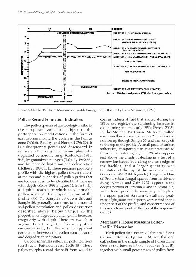
Sediment Description Two inches of dark brown humus (Stratum 1) capping the sediment sequence (fig. 4) had been removed before pollen sampling took place. Stratum 2, a dark brown sandy silt, overlies the irregular surface of the Stratum 3 medium-brown sandy silt and constitutes the fill of a pit feature that had been excavated from the surface of Stratum 3 through Strata 4 and 5 into the upper portion of Stratum 6. This suggests that Stratum 2 is a landscaping fill. It contained no datable artifacts. Stratum 3 consisted of a medium-brown sandy silt containing a mix of ceramics, the most recent
of which was a sherd of a type introduced around 1820. Three other pit features starting at the surface of this stratum were noted (Matamoros 1991: 15–16), and the irregular surface of this stratum suggests considerable human activity before Stratum 2 was deposited. Stratum 4 was an orange-brown mottled sandy silt containing no artifacts, while Stratum 5 consisted of red sand lenses. The most recent of the two ceramic sherds found here was of a type introduced ca. 1762. Stratum 6 consists of the same orange-brown mottled sandy silt as Stratum 4. Several sherds of a ceramic type introduced ca. 1795 were
Figure 1. Merchant’s House Museum facade. (Photo by Jook Lang, 2006.)

158 Kelso and diZerega Wall/Merchant’s House Museum
found among the numerous sherds in the upper 4 in. of this stratum, a sherd postdating ca. 1780 was found near the center of the deposit, and sherds introduced during the middle to early 18th century were found near the bottom of the stratum. Stratum 7 at the bottom of the sequence consisted of orange silty clay containing no artifacts and was classified as preoccupation subsoil (Matamoros 1991: 17). It had been partially disrupted, and single sherds of ceramic types introduced ca. 1720 and 1762 were found at the upper boundary of the stratum.
Pollen-Spectra Description Five pollen zones reflecting significant, culturally driven vegetation changes through time are evident among the Merchant’s House Museum pollen spectra (figs. 5, 6). The deepest
of these (Pollen Zone One) consists of the high percentage (75.5%) of oak (Quercus spp.) pollen in Sample 1. It is accompanied by small percentages of birch (Betula spp.), hickory (Carya spp.), pine (Pinus spp.), cedar family (Cupressaceae), and elm (Ulmus spp.), and also ragweed-type (wind-pollinated aster family, Asteraceae) and aster-type (insect-pollinated aster family) pollen. Pollen Zone Two records the decline in the oak contribution in Sample 2 and above, as chestnut (Castanea dentata) percentages increase up through Sample 7, remain high but irregular through Sample 14, and then drop off abruptly. The increase in chestnut percentages is initially accompanied by the appearance of hazel (Corylus spp.), alder (Alnus spp.), goosefoot/amaranth type (Chenopodiaceae/Amaranthus spp. type), grass (Poaceae), black
Figure 2. Merchant’s House Museum location (Rhys 1911: 134.). (MHM location added by Gerald Kelso, 2013.)

Northeast Historical Archaeology/Vol. 45, 2016 159
locust (Robinia spp.), and modest increases in the birch, hickory, and pine frequencies. These secondary pollen types mostly decline or level off as the chestnut-pol len contribution increases as one proceeds upward in the zone, and are probably products of release and reapplication of statistical constraint in a fixed numerical sum as the oak percentages decline and those of chestnut subsequently rise. Only goosefoot/amaranth-type and ragweed-type percentages increase parallel to the rise in the chestnut contribution. Pollen Zone Three is distinguished by the abrupt increase in the grass-pol len contribution between Sample 15 and Sample 26. Brief spikes of high ragweed-type, aster-type, wormwood, dandelion- (Taraxacum) type, goosefoot/amaranth-type, parsley-family (Apiaceae), and red clover– (Trifolium) type pollen percentages are evident in Samples 16 through 18 at the bottom of this zone. The pollen contributions of these herbs decline above Samples 17 to 18, but most remain present in significant percentages into the pollen zone above. The horizon marker of Pollen Zone Four is a second sudden, larger and more irregular increase in the grass-pollen contributions between Sample 26 and Sample 34. The increase in grass percentages is accompanied by an equally precipitous increase in Eurasian cereal–type percentages and the appearance of sedge (Cyperaceae) and broadleaf plantain– (Plantago major) type pollen as regular elements in the spectrum. Red clover–type and dandelion-type pollen percentages decline in this pollen zone. A decline in grass-pollen percentages is the hallmark of Pollen Zone Five in Samples 35 through 38 at the top of the pollen sequence. It is accompanied by decreases in contributions of aster-type, dandelion-type, Eurasian cereal–type, goosefoot/amaranth-type, parsley-family, red clover–type, sedge-family, and chestnut pollen. An increase in the pollen percentages of oak, hazel, birch, pine, white-spruce (Picea glauca), and total arboreal pollen parallels the herb decline at the top of the profile, and a small block of heath-family (Ericaceae) percentages is evident in the upper two samples.Figure 3. Field-note plan of the Merchant’s House Museum backlot at the time of pollen sampling. (Figure by Diana diZerega Wall, 1995; Computer traced by Gerald Kelso, 2013)
160 Kelso and diZerega Wall/Merchant’s House Museum
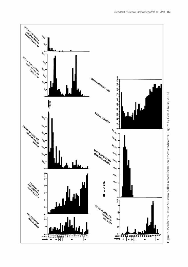
coal as industrial fuel that started during the 1830s and register the continuing increase in coal burning into the early 1950s (Freese 2003). In the Merchant’s House Museum pollen spectrum they appear in Sample 27, increase in number up through Sample 35, and then drop off to the top of the profile. A small peak of carbon spherules, comparable in concentrations to those in Samples 27, 28, and 29, also appear just above the chestnut decline in a test of a narrow landscape bed along the east edge of the backlot, and a larger quantity was tabulated at the top of the same sequence (Kelso and Wall 2014: figure 16). Large quantities of Sporormiella fungal spores from herbivore dung (Ahmed and Cain 1972) appear in the deeper portion of Stratum 6 and in Strata 2–5, with a lesser peak of the same palynomorph in the upper part of Stratum 6. Scattered peat-moss (Sphagnum spp.) spores were noted in the upper part of the profile, and concentrations of this microfossil peak at the top of the sequence (fig. 6).
Merchant’s House Museum Pollen-Profile Discussion Herb pollen does not travel far into a forest (Janssen 1973: 36, figures 3, 6), and the 75% oak pollen in the single sample of Pollen Zone One at the bottom of the sequence (fig. 5), together with small percentages of pollen from
Pollen-Record Formation Indicators The pollen spectra of archaeological sites in the temperate zone are subject to the postdeposition modifications in the form of earthworms mixing the pollen in the humus zone (Walch, Rowley, and Norton 1970: 39). It is subsequently percolated downward in rainwater (Dimbleby 1985: 5) and physically degraded by aerobic fungi (Goldstein 1960: 543), by groundwater oxygen (Tschudy 1969: 95), and by repeated hydration and dehydration (Holloway 1989: 131). These processes produce a profile with the highest pollen concentrations at the top and quantities of pollen grains that are too degraded to be identified that increase with depth (Kelso 1993a: figure 1). Eventually a depth is reached at which no identifiable pollen remains. The upper portion of the profile (fig. 7), Samples 38 down through Sample 26, generally conforms to the normal soil-pollen percolation and pollen destruction described above. Below Sample 26 the proportion of degraded pollen grains increases irregularly with depth. There are two short segments o f s l ight ly h igher po l l en concentrations, but there is no apparent correlation between the pollen concentration and degradation indicators. Carbon spherules reflect air pollution from fossil fuels (Patterson et al. 2005: 35). These palynomorphs record the shift from wood to
Figure 4. Merchant’s House Museum soil profile (facing north). (Figure by Elena Matamora, 1992.)

Northeast Historical Archaeology/Vol. 45, 2016 161
Figu
re 5
. Mer
chan
t’s H
ouse
Mus
eum
arb
orea
l-pol
len
spec
tra.
(Fig
ure
by G
eral
d K
elso
, 201
3.)

162 Kelso and diZerega Wall/Merchant’s House Museum
sprout woodland. Charcoal (fig. 8) appears after the oak-pollen contribution declines, peaks in Sample 8, and remains high through Sample 14, where the chestnut percentages decline. This reflects burning of excess wood in the field, as recommended by the New Netherland secretary to the director and council, Van Tienhoven (Bidwell and Falconer 1941: 9). Ragweeds tolerate the harsh temperatures and moisture regimen of cleared ground better than most other weedy taxa (Bazzaz 1974), and an increase in ragweed-type pollen in lake- and marsh-pollen profiles is generally interpreted as the horizon marker for the advent of European plow agriculture in eastern North America (M. Davis 1983: 179). The steady rise
other arboreal- and herb-pollen types, is consistent with the preclearance pollen spectra of the geographically closest palaeobotanical record (E. Russell 1997: 114). It reflects a local example of the oak-dominated, preclearance forest described by Van der Donck (1968: 19) for New Netherland in general. Chestnut-tree stumps sprout prolifically (Braun 1950: 38; Fowells 1965: 252), and many flower in cleared areas as early as six to ten years after cutting (Hebard 1991: 1). The block of this pollen type, up to 66% between Samples 6 and 14 of Pollen Zone Two, indicates forest clearance by girdling (Smith 1631) or felling the trees with the stumps left in place (Bidwell and Falconer 1941: 8), and the subsequent development of a
Figure 6. Merchant’s House Museum non-arboreal-pollen spectra. (Figure by Gerald Kelso, 2013.)
Northeast Historical Archaeology/Vol. 45, 2016 163
Figu
re 7
. Mer
chan
t’s H
ouse
Mus
eum
pol
len-
reco
rd fo
rmat
ion
proc
ess i
ndic
ator
s. (F
igur
e by
Ger
ald
Kel
so, 2
013.
)

164 Kelso and diZerega Wall/Merchant’s House Museum
Figure 8. Chestnut-pollen percentages and charcoal concentrations in the profile. (Figure by Gerald Kelso, 2013.)
Eurasian-cereal type, other than rye, were noted in the deeper portion of the profile (fig. 9). This cereal-size pollen could be derived from a number of North American grasses producing larger pollen grains, beardgrass (Andropogon spp.) or wild rye (Elymus spp.), for instance. Plowing should also have homogenized the ragweed-type contribution, and the chestnut stumps on the future Merchant’s House Museum locus flourished, rather than rotting out as they were reported to do on cropland. Dung spores appear in significant amounts in the chestnut-dominated spectra of Pollen Zone Two (figs. 6, 7). These might reflect fertilizer applied to an agricultural field. Van der Donck (1968: 30), however, reported that he “had never seen the land manured, and it is seldom done.” Strickland (1971: 72–73), 140 years later, does not mention manure and indicates that farmers simply wore the land out and abandoned it. Between 1748 and 1762, Eliot (1934: 29) complained about the same lack of manure discussed earlier by Van der Donck, and the land depletion and abandonment described later by Strickland (1971: 73). The dung spores among the chestnut-pollen grains probably originated with livestock on the land, rather than with intentionally applied agricultural fertilizer. Livestock were very important to both English and Dutch colonial era farmers (H. Russell 1976; Cohen 1992), and the presence of
in the contribution of ragweed-type pollen from Sample 7 up through Sample 17 (fig. 9), above the top of the block of high chestnut percentages, suggests continuous soil disturbance in the locus. This might indicate plowing between girdled trees or stumps. Observations made in northern New Jersey during the mid-1790s suggest that this was probably not the case. In that area the practice was to break up the ground as much as possible between yard-high stumps and sow wheat or rye the first year. Maize, reputed to encourage rotting of the stumps by providing shade, was sown the second year. Consequently, the stumps were reported to have decomposed rapidly, and when the ground was clear, the regimen of wheat or rye alternating with maize was followed until the ground would not yield anything. It was then abandoned for new clearings (Strickland 1971: 72–73). Maize- (Zea mays) and rye- (Secale cereale) pollen grains are distinguishable from each other and from those of wheat (Triticum spp), oats (Avena spp.), and barley (Hordeum vulgare) by their sizes (Fægri and Iversen 1964: 197). Both are wind transported, but maize, at least, is so poorly dispersed that significantly larger amounts have been recovered from the rows than from the furrows of a prehistoric agricultural field (Berlin et al. 1977: 544). Neither maize pollen nor rye pollen was found in the chestnut-dominated pollen spectra, and only two pollen grains identified by size as

Northeast Historical Archaeology/Vol. 45, 2016 165
appear to be too low and consistent to reflect progressive development of sod. The peak of dung-spore concentrations and increasing percentages of goosefoot/amaranth-type pollen may reflect the introduction of additional livestock to facilitate final clearance. Red clover (Trifolium pratense) is notable among the “English grasses” introduced to improve grazing during the colonial period (H. Russell 1976: 129–131; E. Russell 1997: 96), and there was a flourishing New England market for “English grass” seed from the 1640s on (Romani 1996: 33). The sudden appearance of this pollen type in Pollen Zone Three, other than a single grain of red-clover pollen in Sample 13, together with the abrupt increase in the grass percentages in Sample 16, suggest that the pollen spectrum of the profile segment between Samples 16 and 26 registers planted pasture after sprout-woodland clearance. The large pollen grains of native grasses, diagrammed as Eurasian-cereal type, that are prominent in grass-dominated Pollen Zone Four above are not well represented here, and their low percentages here support the inference that the grass dominating this profile segment was deliberately planted with seed selected to create pasture. The goosefoot/amaranth-type, aster-type, dandelion-type, wormwood, parsley-family, and red clover–type contributions peak immediately after grass-pollen percentages
dung spores in historical era sediment is proportional to the previous abundance of livestock in a locus (O. Davis and Shafer 2006: 41). The quantities of herbivore-dung spores in the deeper portion of the Merchant’s House Museum profile increase upward through the matrix parallel to the chestnut contribution and peak slightly before the chestnut contribution begins its precipitous decline (fig. 9). This indicates that the chestnut-sprout forest was a grazed woodland, and that the soil disturbance registered in the ragweed-type counts was caused by cattle. A number of nitrophilic plants contribute pollen to the goosefoot/amaranth-pollen category (Behre 1983: 236), and the percentages of this pollen type increase up through deeper Stratum 6 parallel to the rising dung-spore concentrations that reflect escalating manure deposition (fig. 10). Cattle grazing on a woodlot create a distinct browse line within 5 to 10 years and destroy the trees, facilitating the development of a complete grass sod within 20 to 40 years (Whitney 1994: 167). The precipitous decline of the chestnut-pollen contribution above Sample 14 and the equally abrupt increase in the grass spectrum in Sample 15 do not, however, fit this model of gradual conversion of grazed woodland to pasture. The grass-pollen percentages in the chestnut-dominated portion of the profile should have increased as browsing opened the woodland to light, but
Figure 9. Spectra of chestnut, ragweed-type, and Eurasian cereal–type pollen. (Figure by Gerald Kelso, 2013.)

166 Kelso and diZerega Wall/Merchant’s House Museum
tall. Equally high grass-pollen percentages (Kelso 1993a: figure 19) were deposited by the well-kept lawn (Kelso 1993b: figure 9A) photographed ca. 1895 at the Kirk Street Agents’ House. Rapid burial preserves pollen spectra from percolation (Kelso et al. 1998: 71; Kelso 2014: 48), and deposition of Stratum 2 reset the pollen-record formation processes, preserving the pollen spectra of Strata 6 and 7 in place, while renewed percolation, dated by carbon spherules, from the 1830s until sampling in 1991 replaced the original pollen content of Strata 2, 3, 4, and 5 with mostly grass pollen from the surface. The spike of dung-spore concentrations in the middle of this profile segment reflect fertilization of the grass in the parterre (fig. 10), while the presence of sedge pollen, which generally reflects moist conditions, indicates that the plot was well watered. The presence of pollen resembling that of broadleaf plantain, which is most common on rich, somewhat-moist soils (Muenscher 1955: 409), is consistent with the presence of both sedge pollen and dung spores. The grass in the center of the backlot and the appearance of a quantity of carbon spherules deep in a side bed, comparable to those deposited in the center of the yard during the 1830s, implies an urban backlot landscape similar to the 1830–1850 layouts of a central grass bed with paths and property-edge flower beds described by Disponzio (1991: 6)
abruptly increase in Sample 16, following a decrease in dung-spore concentrations. The parent plants of these pollen types are all characteristic of ruderal spaces (Muenscher 1955: 430–433, 501), and the brief period of prominence of their pollen suggests a short interval in which the ground was relieved of grazing pressure. The minor peak in dung-spore concentrations in Samples 20 and 21 (fig. 11) of Pollen Zone Three indicates some livestock on the plot, and the presence of a stable on the property by at least 1802 (Wall 1991: 5) supports this inference. A ceramic sherd recovered from the deeper sediment in this first grass-dominated portion of the profile was of a type introduced in 1780, while a second sherd from the upper portion of the grass-dominated portion dates after 1795 (Matamoros 1991: 16). A second abrupt increase in grass percentages (Pollen Zone Four) occurs in the Sample 26 to Sample 28 portion of the profile (fig. 6). The advent of carbon spherules just above the second increase in the grass contribution (fig. 12) indicates that the upper block of high grass percentages originated with a plot of grass established during the 1830s. This was lawn created by either Brewster or Tredwell, possibly with sod, as was the case in the sideyard of the upper middle-class Kirk Street Agents’ House at Lowell, Massachusetts (Robbins 1979: 16–23). The grass standing here need not have been
Figure 10. Chestnut-pollen and dung-spore spectra. (Figure by Gerald Kelso, 2013.)

Northeast Historical Archaeology/Vol. 45, 2016 167
New York City in 1905 (Anderson 1974). The heath-family pollen near the top of the profile is probably derived from ornamentals recorded on the property during the 1960s and 1980s (Wall 1991: 11, 12), and the spike in peat-moss spores in the same pollen zone reflects landscaping products applied to those ornamentals planted during recent decades.
as common for the mid-19th century. The decreases in the pollen contributions of grass, sedge, and broadleaf plantain (Pollen Zone Five) in the most shallow three samples record landscaping changes since 1960 (Wall 1991: 8), while the progressive decrease in the chestnut-pollen percentages in the upper four samples registers the chestnut blight that appeared in
Figure 11. Spectra of grass pollen, other major-herb pollen, and dung spores. (Figure by Gerald Kelso, 2013.)
Figure 12. Grass-family and carbon-spherule spectra. (Figure by Gerald Kelso, 2013.)

168 Kelso and diZerega Wall/Merchant’s House Museum
collecting additional samples, and numerous students at the City College of New York for their work on the project over the years. Myra Harrison, former NPS Northeast Region cultural resources director, and Dwight Pitcaithley, former NPS Northeast Region historian, encouraged archaeological palynology. Brett Keniston of the Denver Public Library and Edward Bell of the Massachusetts Historical Commission provided valuable reference material. The Boston University Department of Archaeology provided laboratory facilities, and pollen laboratory equipment was provided by the National Science Foundation under Grant No. BNS 7924470 to Boston University.
References CitedAhmed, S. Fitkhar, and R. F. Cain 1972 Revision of the Genera Sporormia and
Sporormiella. Canadian Journal of Botany 50(2): 419–477.
Anderson, T. W. 1974 The Chestnut Pollen Decline as a Time
Horizon in Lake Sediments in Eastern North America. Canadian Journal of Earth Science 1 (5): 678–685.
Bazzaz, F. A. 1974 Ecophysiology of Ambrosia artemisiifolia: A
Successional Dominant. Ecology 55(1): 112–119.
Behre, Karl-Ernst 1983 The Interpretation of Anthropogenic
Indicators in Pollen Diagrams. Pollen et Spores 23(2): 225–245.
Benninghoff, William S. 1962 Calculation of Pollen and Spores Density
in Sediments by Addition of Exotic Pollen in Known Amounts. Pollen et Spores 6(2): 332–333.
Berlin, G. L., J. R. Ambler, R. Hevly, and G. Schaber 1977 Identification of a Sinagua Agricultural
Field by Aerial Thermography, Soil Chemistry, Pollen/Plant Analysis, and Archaeology. American Antiquity 42(3): 588–600.
Bidwell, Percy Wells, and John I. Falconer 1941 History of Agriculture in the Northern United
States, 1620–1860. Petyer Smith, New York.
Braun, E. L. 1950 Deciduous Forests of Eastern North America.
Blakiston, Philadelphia.
The Merchant’s House Museum Chestnut Pollen in a Wider Context Small, temporary increases in the chestnut-pollen percentages are visible in a number of historical era lake and marsh spectra from the northeastern United States (Niering 1953: figures 18, 19; Brugam 1978: figures 3, 4; E. Russell et al. 1993: figure 2; Fuller et al. 1998: figure 21). The sampling intervals at which the profiles were collected are too large, the published diagrams of most projects are too small, and the chestnut-pollen data originated too far from the sampling site to identify details of associated changes in the nonarboreal vegetation. Most peaks in the chestnut-pollen contribution were, however, accompanied by contemporaneous increases in ragweed type (Kelso 1994b: figure 3). The Merchant’s House Museum pollen spectra suggest that the transitory periods of prominent chestnut-pollen contributions near the top of northeastern environmental pollen sequences are visible in the regional pollen spectra because chestnut-stump sprouts flower relatively rapidly after the trees were cut, and they reflect temporary, stump-sprouted woodlands that were destroyed by browsing to create pasture during the last step of land clearance.
Summary The Merchant’s House Museum pollen spectrum records an oak-dominated forest that was cleared before the mid-18th century to produce a chestnut-dominated coppice woodland used for grazing. The woodlot was succeeded sometime during the late 18th century by pasture supporting a lesser number of livestock, and the sampled portion of the pasture was converted during the fourth decade of the 19th century to an urban backlot that primarily supported grass.
Acknowledgments Many individuals and organizations have contributed to this research effort. The authors particularly wish to thank Merchant’s House Museum executive director Margaret Halsey Gardiner for support of the project, curator Tina Cuadrado for providing the museum facade photograph by Jook Leung, Elena Matamoros for recording the soil profile and
Northeast Historical Archaeology/Vol. 45, 2016 169
Holloway, Richard G. 1 9 8 9 E x p e r i m e n t a l M e c h a n i c a l P o l l e n
Degradation and Its Application to Quaternary Age Deposits. Texas Journal of Science 41(1): 131–145.
Janssen, C. R. 1973 Local and Regional Pollen Deposition. In
Quaternary Plant Ecology, ed. by H. B. J. Birks and R. G. West, pp. 31–42. Blackwell Scientific, London.
Kelso, Gerald K. 1993a Pollen-Record Formation Processes,
Interdisciplinary Archaeology, and Land Use by Mill Workers and Managers: The B o o t t M i l l C o r p o r a t i o n , L o w e l l Massachusetts, 1836–1942. Historical Archaeology 27(1): 70–94.
1993b The Kirk Street Agents’ House Lowell, Massachusetts: Interdisciplinary Analysis of the Historic Landscape. Landscape Journal 12(2): 143–155.
1994 Palynology in Rural Historical Landscape Studies: Great Meadows Pennsylvania. American Antiquity 59(2): 359–372.
2014 Land Clearance at the ca. 1658–1710 Lieutenant David Fiske Homestead, Lexington, Massachusetts. North American Archaeologist 35(1): 37–54.
Kelso, Gerald K., Andrew C. Edwards, Audrey J. Horning, Marley R. Brown III, and Martha W. McCartney
1998 Exploratory Pollen Analysis of the Ditch of the 1665 Turf Fort, Jamestown, Virginia. Northeast Historical Archaeology 17: 63–84.
Kelso, Gerald K., and Diana diZerega Wall 2014 Pollen Analysis of Two Soil Profiles
Taken in the Merchant’s House Museum Backlot. Manuscript, Merchant’s House Museum, New York.
Matamoros, Ilena M. 1991 Test Cut A. In The Archaeological
Excavations at the Old Merchant’s House, 29 East 4th Street, New York, New York, ed. by Diana di Zerega Wall, pp. 15–17. Manuscript, Merchant’s House Museum, New York.
Mehringer, Peter J., Jr. 1967 Pollen Analysis of the Tule Springs Area,
Nevada. In Pleistocene Studies in Southern Nevada, ed. by H. M. Wormington and D. Ellis, pp. 120–200. Nevada State Museum Anthropological Papers, 13. Carson City.
Muenscher, Walter Conrad 1955 Weeds. Cornell University Press, Ithaca, NY.
Brugam, Richard B. 1978 Pollen Indicators of Land-Use Change in
Southern Connecticut. Quaternary Research 9(3): 349–362.
Cohen, David Steven 1992 The Dutch-American Farm. New York
University Press, New York.
Davis, M. B. 1983 Holocene Vegetational History of the Eastern
United States. In Late-Quaternary Environments of the United States. Vol. 2. The Holocene, ed. by Herbert E. Wright, Jr., pp. 166–181. University of Minnesota Press, Minneapolis.
Davis, Owen K., and David S. Shafer 2006 S p o r o r m i e l l a F u n g a l S p o r e s : A
Palynological Means of Detect ing Herbivore Density. Palaeogeography, Paleoclimatology, Paleoecology 237(1): 40–50.
Dimbleby, Geoffrey W. 1985 The Palynology of Archaeological Sites.
Academic Press, London.
Disponzio, Joseph 1992 The Old Merchant’s House Historic
L a n d s c a p e R e p o r t . M a n u s c r i p t , Merchant’s House Museum, New York.
Eliot, Jared 1934 Essays Upon Field Husbandry in New England
and Other Papers: 1748–1762, ed. by Harry J. Carmon and Rexford G. Tugwell. Columbia University Press, New York.
Fægri, Knut, and Johs. Iversen 1964 Textbook of Pollen Analysis. Hafner, New York.
Fowells, H. A. 1965 Silvics of Forest Trees of the United States.
U.S. Department of Agriculture, Forest Service, Washington, DC.
Freese, Barbara 2003 Coal: A Human History, Penguin, New York.
Fuller, Janice L., David R. Foster, Jason S. McLachlan, and Natalie Drake
1998 Impact of Human Activity on Regional Forest Composition and Dynamics in Central New England. Ecosystems 1: 76–95.
Goldstein, Solomon 1960 Degradation of Pollen by Phycomycetes.
Ecology 41(3): 543–545.
Hebard, Frederick V. 1991 Locating Flowering American Chestnut
Trees. Journal of the American Chestnut Foundation 6(2): 98–100.

170 Kelso and diZerega Wall/Merchant’s House Museum
Strickland, William 1971 Journal of a Tour in the United States of
America, 1794–1795, ed. by T. E. Strickland. New-York Historical Society, New York.
Tschudy, R. S. 1969 Relat ionship of Palynomorphs to
Sedimentation. In Aspects of Palynology, ed. by R. H. Tschudy and R. S. Scott, pp. 79–96. John Wiley & Sons, New York.
Van der Donck, Adriaen 1968 Description of the New Netherlands, trans. by
Jeremiah Johnson. Syracuse University Press, Syracuse, NY.
Walch, K. M., J. R. Rowley, and N. J. Norton 1970 Displacement of Pollen Grains by
Earthworms. Pollen et Spores 12(1): 39–44.
Wall, Diana di Zerega 1991 The Archaeological Excavations at the Old
Merchant’s House, 29 East 4th Street, New York, New York. Manuscript, Merchant’s House Museum, New York.
Whitney, Gordon G. 1994 From Coastal Wilderness to Fruited Plain.
Cambridge University Press, Cambridge, UK
Author InformationGerald K. Kelso earned a Ph. D in anthropology at the University of Arizona, while serving as a research assistant/research associate at the Laboratory of Paleoenvironmental Studies at that Institution. He currently studies the palynology of archaeological sites in northeastern North America.
Gerald K. Kelso.2865 East Cinnabar Ave.Phoenix, [email protected].
Diana diZerega Wall is a professor at the City College and the Graduate Center, CUNY. She studies the archaeology of New York City from the time of the European and African arrivals in the 17th century up through the 19th.
Diana diZerega WallThe City College of New YorkAnthropology Department160 Convent AveNew York, NY [email protected]
Niering, William A. 1953 The Past and Present Vegetation of High
Point State Park, New Jersey. Ecological Monographs 23(2): 127–148.
Patterson, William A., Julie A. Richburg, Kennedy H. Clark, and Sally Shaw
2005 Paleoecology of Calf Island in Boston’s Outer Harbor. Northeastern Naturalist 12(S3): 31–48.
Robbins, John 1979 Historic Structure Report: Architectural Data,
Boott Cotton Mills and Massachusetts Cotton Mills Agents’ Houses, 67 and 63 Kirk Street, Lowell National Historical Park, Lowell, Middlesex County, Massachusetts. Manuscript, U.S. Department of the Interior, National Park Service, Denver Service Center, Denver, CO.
Romani, Daniel A., Jr. 1996 “Our English Clover-grass Sowen Thrives
Very Well”: The Importation of English Grasses and Forages into Seventeenth Century New England, In Plants and People, ed. by Peter Benes, pp. 25-37. Boston University, Boston, MA.
1997 People and the Land Through Time: Linking Ecology and History. Yale University Press, New Haven, CT.
Russell, Emily W. B., Ronald B. Davis, R. Scott Anderson, Thomas E. Rhodes, and Dennis S. Anderson
1993 Recent Centuries of Vegetational Change in the Glaciated North-Eastern United States. Journal of Ecology 81: 647–664.
Russell, Howard S. 1976 A Long Deep Furrow. University Press of
New England, Hanover, NH.
Rhys, Ernst, ed. 1911 A Literary and Historical Atlas of North and
South America. E. P. Dutton & Co., New York.
Sharp, Lewis Inman 1968 The Old Merchant’s House: An 1831/32
Row House. MA thesis, University of Delaware, Newark.
Smith, John 1631 Advertisements for the Unexperienced
Planters of New England, or Anywhere. John Haviland, London.
Stokes, Isaac Newton Phelps 1926 The Iconography of Manhattan Island. Vol. 6.
Robert H. Dodd, New York.