fort collins science center invasive species science branch · pacific ocean, across the united...
TRANSCRIPT

U.S. Department of the InteriorU.S. Geological Survey
Fact Sheet 2014–3076March 2015
FORT COLLINS SCIENCE CENTER Invasive Species Science BranchResearch and Management Tools for Controlling Invasive Species
Biology, Impacts, and Control of Invasive Reptiles
Invasive species are considered to be second only to habitat degradation in terms of negative impacts on the Earth’s ecosystems, and our scientists make up a significant propor-tion of the global expertise in the rapidly-growing problem of invasive reptiles. Long-term research on Guam has led to development and validation of numerous effective control tools, while more recent research in Florida and elsewhere focuses on understanding impacts and control opportunities for
Photograph from USGS.
CapabilitiesInvasive, nonnative species of plants, animals, and disease organ-
isms adversely affect the ecosystems they enter. Like “biological wildfires,” they can quickly spread and affect nearly all terrestrial and aquatic ecosystems. Invasive species have become one of the greatest environmental challenges of the 21st century in economic, environmen-tal, and human health costs, with an estimated effect in the United States of more than $120 billion per year. Managers of the Department of the Interior (DOI) and other public and private lands often rank invasive spe-cies as their top resource management problem. The Invasive Species Science (ISS) Branch of the Fort Collins Science Center (FORT) provides research and technical assistance relating to management concerns for invasive species, including understanding how these species are intro-duced, identifying areas vulnerable to invasion, forecasting invasions, and developing control methods. To disseminate this information, branch scientists are developing platforms to share invasive species information with DOI cooperators, other agency partners, and the public. From these and other data, branch scientists are constructing models to understand and predict invasive species distributions for more effective management. The branch also has extensive herpetological and population biology expertise that is applied to harmful reptile invaders such as the Brown Treesnake on Guam and Burmese Python in Florida.
Photograph from Björn Lardner, Colorado State University.
Burmese pythons and other recent invaders. Branch scientists combine extensive herpetological expertise with cutting-edge quantitative skills to estimate detection probability, population size, and eradication prospects for a range of invasive reptiles. Projects and collaborators span the globe, from the western Pacific Ocean, across the United States mainland, to Puerto Rico and beyond.
Species Distribution Modeling
A requirement for managing a species, be it a common native species, a species of conservation concern, or an inva-sive species, is having some information on its distribution and potential drivers of distribution. Branch scientists have been tackling the question of where these types of species are and where they might be in the future. Focus species are as varied as the invasive tamarisk, Russian olive, Africanized honey bee and nutria to the federally threatened Lesser Prairie chicken and others. These and other species are modeled at a variety of spatial scales, from park or wildlife refuge to global levels. Models use various predictor layers that can include current and future climate layers (near- and long-term projec-tions), remote-sensing derivatives (such as MODIS phenology metrics), land cover, topography, and anthropogenic features.
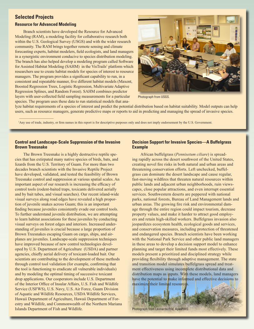
Selected ProjectsResource for Advanced Modeling
Branch scientists have developed the Resource for Advanced Modeling (RAM), a modeling facility for collaborative research both within the U.S. Geological Survey (USGS) and with the wider research community. The RAM brings together remote sensing and climate forecasting experts, habitat modelers, field ecologists, and land managers in a synergistic environment conducive to species distribution modeling. The branch has also helped develop a modeling program called Software for Assisted Habitat Modeling (SAHM) in the VisTrails1 platform which researchers use to create habitat models for species of interest to resource managers. The program provides a significant capability to run, in a consistent and repeatable manner, five different habitat models (Maxent, Boosted Regression Trees, Logistic Regression, Multivariate Adaptive Regression Splines, and Random Forest). SAHM combines predictor layers with user-collected field sampling measurements for a particular species. The program uses these data to run statistical models that ana-lyze habitat requirements of a species of interest and predict the potential distribution based on habitat suitability. Model outputs can help users, such as resource managers, generate predictive maps or reports to aid in predicting and managing the spread of invasive species.
Photograph from USGS.
1Any use of trade, industry, or firm names in this report is for descriptive purposes only and does not imply endorsement by the U.S. Government.
Control and Landscape-Scale Suppression of the Invasive Brown Treesnake
The Brown Treesnake is a highly destructive reptile spe-cies that has extirpated many native species of birds, bats, and lizards from the U.S. Territory of Guam. For more than two decades branch scientists with the Invasive Reptile Project have developed, validated, and tested the feasibility of Brown Treesnake control and suppression at various spatial scales. An important aspect of our research is increasing the efficacy of control tools (rodent-baited traps, toxicants delivered aerially and by bait tubes, and visual searches). Our recent island-wide visual surveys along road edges have revealed a high propor-tion of juvenile snakes across Guam; this is an important finding because juveniles consistently evade our control tools. To further understand juvenile distribution, we are attempting to learn habitat associations for these juveniles by conducting visual surveys on forest edges and interiors. Increased under-standing of juveniles is crucial because a large proportion of Brown Treesnakes escaping Guam on cargo, ships, and air-planes are juveniles. Landscape-scale suppression techniques have improved because of new control technologies devel-oped by U.S. Department of Agriculture (USDA) and partner agencies, chiefly aerial delivery of toxicant-loaded bait. Our scientists are contributing to the development of these methods through control tool validation (for example, confirming that the tool is functioning to eradicate all vulnerable individuals) and by modeling the optimal timing of successive toxicant drop applications. Our cooperators include U.S. Department of the Interior Office of Insular Affairs, U.S. Fish and Wildlife Service (USFWS), U.S. Navy, U.S. Air Force, Guam Division of Aquatic and Wildlife Resources, USDA Wildlife Services, Hawaii Department of Agriculture, Hawaii Department of For-estry and Wildlife, and Commonwealth of the Northern Mariana Islands Department of Fish and Wildlife.
Decision Support for Invasive Species—A Buffelgrass Example
African buffelgrass (Pennisetum ciliare) is spread-ing rapidly across the desert southwest of the United States, creating novel fire risks in both natural and urban areas and threatening conservation efforts. Left unchecked, buffel-grass can dominate the desert landscape and cause regular, fast-moving wildfires that threaten natural resources within public lands and adjacent urban neighborhoods, ruin views-capes, close popular attractions, and even interrupt essential services. Southwestern deserts are peppered with national parks, national forests, Bureau of Land Management lands and urban areas. The growing fire risk and environmental dam-age through the entire region could impact tourism, decrease property values, and make it harder to attract good employ-ers and retain high-skilled workers. Buffelgrass invasion also jeopardizes ecosystem health, ecological goods and services, and conservation measures, including protection of threatened and endangered species. Branch scientists have been working with the National Park Service and other public land managers in these areas to develop a decision support model to enhance planning and target their limited funds most effectively. These models present a prioritized and disciplined strategy while providing flexibility through adaptive management. The state and transition model simulates buffelgrass spread and treat-ment effectiveness using incomplete distributional data and distribution maps as inputs. With these models, land managers have the potential to make informed and effective decisions to maximize their limited resources.
Photograph from Leonardo Frid, ApexRMS.

Ecology and Control of Invasive Reptiles in Florida
The Florida Everglades encompass a vast subtropical ecosystem including Everglades National Park, which is the only place in the United States designated as a World Heritage Site, an International Biosphere Reserve, and a Wetland of International Significance. Bil-lions of dollars have been committed to the long-term restoration of this ecosystem, but burgeoning populations of introduced and inva-sive reptiles threaten prospects for restoration. The Burmese python is the most widely known of these invaders, and this giant snake appears to have contributed to drastic declines among several species of mid-sized mammals in the Everglades. However, other large predatory species including the Argentine tegu and Northern African Python are also established in southern Florida, and the potential impacts of these species are not widely understood. FORT scientists are conduct-ing research on a range of detection and control tools for invasive reptiles in Florida, including environmental DNA sampling methods, trap development and field testing, and validation of visual searching efficacy. Scientists are also conducting basic ecological research to better understand impacts of these invasive predators and to identify ecological or behavioral vulnerabilities that can be exploited by control tools.
Modeling Invasive Species Distribution—A Nutria Example
Nutria or coypu (Myocastor coypus) are invasive rodents native to South America that cause wetland degradation and have become established in many parts of the world, including the South-east and the Pacific Northwest within the United States. Large-scale management of the species requires knowledge of its potential dis-tribution. Working with researchers at the USGS National Wetlands Research Center, we are developing models of potential distribution in the United States. Branch scientists have created a physiological model built on cold temperature limitations and a statistical model based on creating relationships between observations and environ-mental characteristics at the locations. Using these base models, our objective is to develop a comprehensive model of potential suitable habitat for nutria globally and within the United States. This model can be applied to future climate scenarios to determine how nutria distribution may change, guiding management efforts including highlighting areas for early detection.
Photograph from Paul Andreadis, Denison University.
Photograph from USGS.
Brown Treesnake Rapid Response Team
Brown Treesnakes continue to cause major problems for the ecology, economy, and quality of life on Guam. In 2002, a multi-agency Rapid Response Team (RRT) led by USGS was established to assist with detection and capture of Brown Treesnakes on recipient islands if a snake was accidentally transported from Guam. The RRT has incorporated a wide range of research results from the USGS Invasive Reptiles Project, such as means to improve snake detectability at low densities, effectiveness of control tools in rodent-rich environments, and predicting movements of snakes translocated accidentally. The primary RRT activities are conducting training courses on Guam for team members stationed on other islands and conducting and managing multi-agency responses when a snake is sighted on an island other than Guam. Training courses on Guam include extensive visual searching to develop the ability to find and capture snakes, as well as instruction on use of snake traps and proper interview techniques when gathering snake observation data from the public. The Rapid Response Team coordinator also performs outreach and public education on Brown Treesnakes throughout the Pacific region. Cooperators include the DOI Office of Insular Affairs, USFWS, U.S. Commonwealth of the Northern Mariana Islands, U.S. Department of Defense, USDA Wildlife Services, Guam Division of Aquatic and Wildlife Resources, Hawaii’s Coordinating Group on Alien Pest Species and Invasive Species Committees, Hawaii Department of Agriculture, and Hawaii Department of Forestry and Wildlife. Additional quarantine, agriculture, and natural resources cooperators include officials from the Federated States of Micronesia, the Republic of the Marshall Islands, and the Republic of Palau.

Contact InformationBob Reed, Ph.D., Branch Chief
U.S. Geological Survey Fort Collins Science Center2150 Centre Avenue, Building CFort Collins, Colorado 80526-8118Tel. 970.226.9464 Fax [email protected]
Learn more about FORT science, products, and resources at http://www.fort.usgs.gov
Invasive Species Science Branch Web site: http://fort.usgs.gov/ISS/
Photograph from Leá Bonewell, USGS.
Research to Support Bird Restoration and Recovery on Guam
On Guam, the endangered Mariana swiftlet is a bird species restricted to three caves on Naval Base Guam while many other native birds are either extinct or awaiting reintroduction (for example, Guam Rail). The invasive Brown Treesnake (BTS) played a major role in the loss of native avifauna and may be pre-venting swiftlet population recovery and limiting the potential for reintroductions. Operational BTS trapping by the USDA Animal and Plant Health Inspection Service (APHIS) Wildlife Services reduces BTS in areas of concern across Guam. For example, trapping occurs in the vicinity of swiftlet-occupied caves, but surveys suggest that BTS frequently penetrate the trap ring and access caves. If the few BTS that penetrate the trap ring become resident after entering the cave, a small number of BTS could have a disproportionate impact on swiftlet populations. Similarly, the Guam National Wildlife refuge has recently installed a fence to exclude BTS and initiated a trapping program to reduce snake populations and create conservation space for potential avian reintroductions. Branch scientists are working with these Federal agencies to assess the efficacy of control tool deployment in areas of conservation concern. Research focuses on (1) the best control tool deployment methods for optimizing BTS intercep-tion rates and decreasing predation on prey of conservation con-cern; and (2) understanding levels of BTS suppression required to reduce snake predation on birds to levels that allow persistence of native bird populations.
Photograph from Björn Lardner, Colorado State University.
StaffBranch Chief: Bob Reed, Ph.D., Supervisory Research Wildlife Biologist, [email protected]
Colorado-based staff:Bonewell, Lea, B.S., Project Manager, [email protected] Jarnevich, Catherine, Ph.D., Ecologist, [email protected], Page, Ph.D., Ecologist, [email protected] Yackel Adams, Amy, Ph.D., Statistician, [email protected], Mark, Ph.D., Contracted Ecologist, [email protected]
Florida-based staff:Falk, Bryan, Ph.D., Biologist, [email protected] McEachern, Michelle, B.S., Biological Science Technician, [email protected]
Guam-based staff:Knox, Adam, M.S., Rapid Response Coordinator, [email protected] Tadevosyan, Tigran, Ph.D., Contracted Research Manager, [email protected] Contracted Biologists: Barnhart, Patrick, B.S., Hinkle, Thomas, B.S., Hogan, Michael, B.S., Holldorf, Elden, B.S., Kaseman, Justine, B.S., Robinson, Charlotte, B.S.St. Aublin, Gregory, Contracted BiologistMarijoy Viernes, Contracted Biologist
Colorado State University cooperators:Savidge, Julie, Ph.D., Ecologist, [email protected], Björn, Ph.D., Ecologist, [email protected], Shane, Ph.D., Ecologist, [email protected]
ISSN 2327-6932 (online)http://dx.doi.org/10.3133/fs20143076