forrestfield airport link project survey of floristic ......confidential forrestfield airport link...
TRANSCRIPT
CONFIDENTIAL
Forrestfield Airport Link Project
Survey of Floristic Community Types
East of Dundas Road – Addendum
Report Prepared by
RPS
FAL-PTAWA-EN-RPT-00015

2 Forrestfield Airport Link: Report Name | Date
Version control
Version No. Date Document Status
Prepared By Endorsed By
0 06-05-15 Approved RPS Chris Watts
A 23-04-15 Draft RPS Chris Watts
Approvals
The signatures below certify that this report has been reviewed, endorsed and approved, and that
the signatories are aware of all the requirements contained herein and are committed to ensuring
their provision.
Reviewed
………………………………………………Signature Date
Paul Monaghan Environmental Manager
Approved
………………………………………………Signature Date
Dave Thomas Delivery Manager

SURVEY OF
FLORISTIC COMMUNITY TYPES
EAST OF DUNDAS RD,
FOR THE
FORRESTFIELD AIRPORT LINK
PROJECT
ADDENDUM REPORT:
ADDITIONAL ANALYSIS
Prepared for Public Transport Authority of Western Australia
by
Brian Morgan Consultant Botanist
May 2015

TABLE OF CONTENTS
1.0 INTRODUCTION ................................................................................................................... 1 1.1 Background ............................................................................................................................ 1 1.2 Scope of the study.................................................................................................................... 1 2.0 METHODS AND LIMITATIONS ............................................................................................. 3 2.1 PATN analyses of vegetation units and Floristic Community Types (FCTs) ..................................... 3 2.1.1 Introduction.......................................................................................................................... 3 2.1.2 Data compatibility ................................................................................................................. 3 2.1.3 Data preparation ................................................................................................................... 3 2.1.4 PATN analyses and determination of FCT ................................................................................ 4 2.1.5 Limitations of the floristic analysis .......................................................................................... 4 3.0 FLORISTIC COMMUNITY TYPES, THREATENED ECOLOGICAL COMMUNITIES AND PRIORITY ECOLOGICAL COMMUNITIES ................................................................................... 6 3.1 Floristic analysis ...................................................................................................................... 6 3.1.1 PATN analysis and FCTs ....................................................................................................... 6 3.1.2 Status of the FCTs in the survey area: Threatened Ecological Communities and Priority Ecological Communities ................................................................................................................. 7 4.0 CONCLUSION ..................................................................................................................... 12 5.0 ACKNOWLEDGEMENTS..................................................................................................... 13 6.0 REFERENCES...................................................................................................................... 14 APPENDICES ............................................................................................................................ 15 APPENDIX ONE. PATN Analysis: survey area data and Gibson et al. SCP datasets, weed species removed ..................................................................................................................................... 16 APPENDIX TWO. PATN Analysis: inclusion of supplementary SCP data, weed species removed ........ 17

1
1.0 INTRODUCTION 1.1 Background The Forrestfield-Airport Link project aims to construct a spur rail line from the Bayswater Station/Midland line through to the eastern suburb of Forrestfield and includes a station servicing the Perth airport. In 2014 a study that included 10 quadrats in two areas in the High Wycombe locality (Areas 3 and 4, Figure 1), was undertaken for the Public Transport Authority (PTA) to confirm the vegetation Floristic Community Types (FCTs) and hence the presence of Threatened Community Types (TECs) in those areas. However, the statistical results of the study were not definitive and were not consistent with mapped TECs east of the study area and in the same locality. In addition, a review of the results suggested that the higher number of weed species present in the study area sites than in Gibson et al. (1994) FCT sites suggested that weed species may be biasing the results. It was also considered that the inclusion of DPaW data collected on the SCP after the Gibson et al. (1994) SCP study and subsequently analysed with the Gibson et al. (1994) dataset (‘supplementary data’) and which included additional sites on the eastern SCP, could improve the accuracy and clarity of the results. 1.2 Scope of the study The PTA directed that further analysis be undertaken on the data collected during the 2014 survey and that the additional analysis should include re-running PATN analysis of field data against the Gibson et al. (1994) SCP dataset following:
• The removal of weed taxa from both data sets. • Inclusion of DPaWs ‘supplementary data’ and the removal of weed taxa from
all datasets.

DUNDAS ROADDUNDAS ROAD
MAIDA VALE ROADMAIDA VALE ROAD
KEWDALEKEWDALEFREIGHTFREIGHT
TERMINALTERMINAL
AREA 4
AREA 3
Figure 1
Site Location0 100 20050m
°Job Number: I1323907Doc Number: 004Date: 20.04.15
Created by: RASource: Orthophoto - Landgate, Nov 2014
LEGENDSurvey Area
38 Station Street, Subiaco | T +61 8 92111111 | F +61 8 92111122 |www.rpsgroup.com.au
Scale: 1:5,000 @ A3 GDA 1994 MGA Zone 50
20 km 10 km
CANNING VALECANNING VALE
MORLEYMORLEY
ELLENBROOKELLENBROOK
HILLARYSHILLARYS
MIDLANDMIDLAND
FREMANTLEFREMANTLE
SCARBOROUGHSCARBOROUGH
PERTHPERTH
0 105km
Site Location

3
2.0 METHODS AND LIMITATIONS 2.1 PATN analyses of vegetation units and Floristic Community Types (FCTs) 2.1.1 Introduction The PATN analyses (numerical classification techniques) compared the similarity of species presence data collected at the 10 survey quadrats with the 509 site SCP dataset (Gibson et al., 1994). The methodology for the two analyses undertaken for this report was the same as that outlined in detail in the main report (Morgan, 2015), with the exception that in the first analysis weed species were removed from the combined datasets, while in the second analysis the dataset included an additional 590 DPaW supplementary sites in the SCP dataset (total of 1098 sites) and weed species were removed from all datasets (Keighery, 2012). Mr Ted Griffin undertook the analyses and has outlined and detailed the methods used in his reports (Appendices 1 and 2). 2.1.2 Data compatibility The survey data was reasonably compatible with the SCP dataset, in that both datasets were based on data collected from quadrats of the same size (10 metres by 10 metres) from two visits per site including one in optimal season (Spring). Most of the survey quadrats were also recorded in vegetation that was in ‘Very Good’ condition and had high species counts. The exceptions to this were three quadrats in Area 3 (ARQ7, ARQ8 and ARQ11 ) on the Poison Gully creek banks and adjacent slopes. Overall, the differences in quadrat sampling with the DPaW datasets were kept to a minimum, with the exceptions noted above (particularly quadrat ARQ7). 2.1.3 Data preparation Plant taxa names were reconciled between the survey data, the Gibson et al. (1994) data and the Keighery et al. (2012) dataset. This process was outlined in Morgan (2015). Weed species were removed from the datasets.

4
2.1.4 PATN analyses and determination of FCT Two analyses were undertaken with the following characteristics:
• Dataset of 10 survey quadrats with the 509 site Gibson et al. (1994) SCP dataset, with weed species removed from the combined dataset.
• Dataset of 10 survey quadrats with the 1098 Keighery et al. (2012) SCP dataset (comprised of 508 Gibson et al. (1994) SCP dataset and 590 supplementary sites, reconciled to 2005 taxonomy).
The PATN analyses used dendrogram classification (with both an ‘all site’ classification and a single site insertion (SSI) classification) and a nearest neighbour (NNB) analysis as methods to determine site FCTs. The SSI classification analysis involved running the cluster analysis for each survey site, one at a time, with the respective SCP datasets. SSI is considered a more powerful and reliable means of deriving a dendrogram classification for each survey site as it causes less ‘disruption’ of the clustering of the SCP datasets. When all survey sites are included together in a clustering analysis with the SCP dataset sites ‘all site analysis’, it can cause disruption and some reorganisation of the SCP sites. The SSI classification analysis is closely analogous to the Gibson et al. (1994) analysis that determined the FCTs because it uses the same algorithm for the classification used by Gibson et al. (1994), with only the one additional site considered. The NNB analysis isn’t a classification process, but is an indirect process for assigning a SCP FCT to a survey site by determining which SCP dataset sites are most floristically similar to it (measured by an index of dissimilarity). Each of the survey sites could, in turn, be assigned to the same FCT as that of the most similar SCP dataset sites. DPaW undertook their study of the SCP supplementary sites with the Gibson et al. (1994) sites, using the PATN module ALOC, which ‘fixed’ the groupings of Gibson et al. (1994) sites (FCTs) and allocated the supplementary sites to those FCTs or, where site groups were too dissimilar, to new FCTs (see descriptions in Appendices 1 and 2). For this study, Griffin did not use the ALOC module. 2.1.5 Limitations of the floristic analysis It has been found in other floristic analyses that the addition of new sites to the Gibson et al. (1994) SCP dataset to produce a combined classification, may disrupt

5
the original Gibson et al. (1994) classification of sites (Griffin and Trudgen, 2004). The more data that is added, the higher the level of disruption. If this occurs it can make it difficult to assign the new sites to a Gibson et al. (1994) FCT (Griffin and Trudgen, 2004). The application of a SSI classification largely overcame this limitation. Another limitation in conducting a PATN floristic analysis using the above methods may arise depending on the degree of success in reconciling the data sets. A further limitation may arise from any significant differences in data collection methods between the two surveys. However, the data sets were considered reasonably compatible for this data analysis. Finally, the success of the PATN analysis to assign a SCP FCT to survey sites can be limited to the extent that the type of vegetation in the study area was sampled in the Gibson et al. (1994) SCP survey, allowing comparison with the outcomes of the SCP dataset analysis. The inclusion of the supplementary data significantly moderated this limitation since it included numerous sites from the eastern SCP and more particularly, from the study area locality.

6
3.0 FLORISTIC COMMUNITY TYPES, THREATENED ECOLOGICAL COMMUNITIES AND PRIORITY ECOLOGICAL COMMUNITIES This section outlines the results of additional floristic analysis conducted by Mr Ted Griffin on the survey data and the SCP datasets. It is based on two reports prepared by Ted Griffin, which are included in Appendices 1 and 2. 3.1 Floristic analysis 3.1.1 PATN analysis and FCTs The results for the Area 3 and Area 4 sites from the PATN ‘all sites’ and SSI classifications and NNB analysis of all survey sites (10 in Areas 3 and 4 and 6 in adjacent areas (not covered in this report)) for the ‘no weeds’ and ‘supplementary & no weeds’ analyses, are presented in Table 1. Results from the initial study (Morgan 2015) are also included in Table 1 for comparison. It can be seen from Table 1 that the analysis with the weeds removed (‘no weeds analysis’) resulted in some, mostly small, changes in the FCT results, with a small shift towards FCT20a observed in some cases (sites ARQ5, ARQ10 and ARQ13). The detailed results for the ‘no weeds analysis’ are shown in Table 2 in Appendix 1. The inclusion of the supplementary data (‘supplementary & no weeds analysis’) caused a very significant change in the results. In Area 3, the creek and gully vegetation sites (ARQ7 and ARQ8) firmed towards FCT3c, while the sites on the plain adjacent to Poison Gully moved towards FCT20a (ARQ5, ARQ6 and ARQ11). In Area 4 there was a significant change with four of five sites found to be FCT20a and the other site, ARQ14, found to be FCT20a/21a. The significant shift in the results towards FCT20a is due to vegetation floristics in survey area sites being similar to that in numerous FCT20a supplementary sites recorded in vegetation in the survey area locality and adjacent areas. For example, four of the five nearest neighbours to site ARQ5 were all FCT20a supplementary sites and seven of the ten nearest neighbours to ARQ5 were FCT20a supplementary sites (Table 1 in Appendix 2). The FCTs mapped in Areas 3 and 4 were: FCT3c, FCT20a, FCT20b and FCT21c (Figures 2 and 3). Two of the quadrat FCTs presented problems for mapping FCTs. These problems and the resolution of the mapped FCTs were as follows.
7
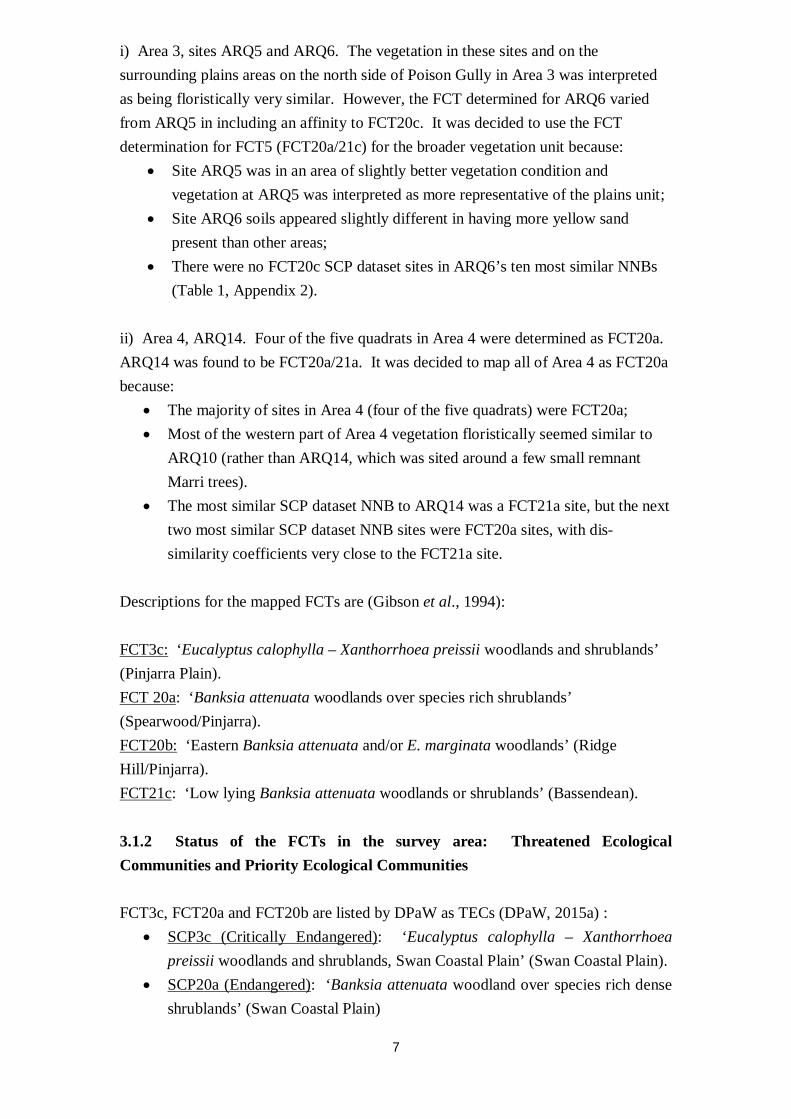
i) Area 3, sites ARQ5 and ARQ6. The vegetation in these sites and on the surrounding plains areas on the north side of Poison Gully in Area 3 was interpreted as being floristically very similar. However, the FCT determined for ARQ6 varied from ARQ5 in including an affinity to FCT20c. It was decided to use the FCT determination for FCT5 (FCT20a/21c) for the broader vegetation unit because:
• Site ARQ5 was in an area of slightly better vegetation condition and vegetation at ARQ5 was interpreted as more representative of the plains unit;
• Site ARQ6 soils appeared slightly different in having more yellow sand present than other areas;
• There were no FCT20c SCP dataset sites in ARQ6’s ten most similar NNBs (Table 1, Appendix 2).
ii) Area 4, ARQ14. Four of the five quadrats in Area 4 were determined as FCT20a. ARQ14 was found to be FCT20a/21a. It was decided to map all of Area 4 as FCT20a because:
• The majority of sites in Area 4 (four of the five quadrats) were FCT20a; • Most of the western part of Area 4 vegetation floristically seemed similar to
ARQ10 (rather than ARQ14, which was sited around a few small remnant Marri trees).
• The most similar SCP dataset NNB to ARQ14 was a FCT21a site, but the next two most similar SCP dataset NNB sites were FCT20a sites, with dis-similarity coefficients very close to the FCT21a site.
Descriptions for the mapped FCTs are (Gibson et al., 1994): FCT3c: ‘Eucalyptus calophylla – Xanthorrhoea preissii woodlands and shrublands’ (Pinjarra Plain). FCT 20a: ‘Banksia attenuata woodlands over species rich shrublands’ (Spearwood/Pinjarra). FCT20b: ‘Eastern Banksia attenuata and/or E. marginata woodlands’ (Ridge Hill/Pinjarra). FCT21c: ‘Low lying Banksia attenuata woodlands or shrublands’ (Bassendean). 3.1.2 Status of the FCTs in the survey area: Threatened Ecological Communities and Priority Ecological Communities FCT3c, FCT20a and FCT20b are listed by DPaW as TECs (DPaW, 2015a) :
• SCP3c (Critically Endangered): ‘Eucalyptus calophylla – Xanthorrhoea preissii woodlands and shrublands, Swan Coastal Plain’ (Swan Coastal Plain).
• SCP20a (Endangered): ‘Banksia attenuata woodland over species rich dense shrublands’ (Swan Coastal Plain)

8
• SCP20b (Endangered): ‘Banksia attenuata and/or E. marginata woodlands of the eastern side of the Swan Coastal Plain’ (Swan Coastal Plain).
FCT3c is listed under the Commonwealth EPBC Act of Threatened Ecological Communities (Australian Govt, 2015):
• ‘Corymbia calophylla – Xanthorrhoea preissii woodlands and shrublands of the Swan Coastal Plain’, Endangered
FCT21c is listed as a Priority Ecological Community by DPaW (DPaW, 2015b):
• ‘Low lying Banksia attenuata woodlands or shrublands (‘community type 21c’), Priority 3’.

9
Table 1. FCTs estimated from the all-sites PATN dendrogram classification and nearest neighbours analysis (NNB) and from a single site insertion (SSI) PATN dendrogram classification (see Appendices 1 and 2).
Project Area Site
Previous Results: Griffen
Summary FCT
(Table 2, Morgan 2015) d
Previous Results: Authors
Final FCT Determina
tion (Table 2, Morgan 2015) d
No weeds analysis: Griffen
Summary FCTc
Supplement-ary & No
weeds analysis:
Dendrogram FCT e
Supplement-ary & No
weeds analysis:
NNB a FCT
Supplement-ary & No
weeds analysis:
SSI b FCT
Supplement-ary & No
weeds analysis: Griffen
Summary FCTe
Area 3 ARQ5 ?28/21c 21c/28/20c ??21c/20a 20a 20a 21c/20a 20a/21c Area 3 ARQ6 ?28 21c/28/20c ??3b/21c 20a 20a 21c/20c 20a/20c/21c Area 3 – creek banks ARQ7 ?11 ?11 ???11/21a 3c ??3c 3c ??3c Area 3 – gully slopes ARQ8 ?3c ?3c ?3c 3c ?3c 3c ?3c Area 3 – gully slopes ARQ11 ?3b ?3b/20c ?3b 20a 20a 20b/28/3b 20a/20b Area 4 - west ARQ9 21a/20b/20c 20c/21a 21a/20b 20a 20a 20a 20a Area 4 - west ARQ10 20a/21a 20c/21a 20a 20a 20a 20a 20a Area 4 - west ARQ14 20c 20c/21a 21a/3b 20a 21a/20a 21a/3b/20b 20a/21a Area 4 - east ARQ13 4/21c/20c 3b/20c 20c/20a 20a 20a/?20c 20a 20a Area 4 - east ARQ15 3b 3b/20c 3b/20c/21a 20a 20a 20a 20a
a NNB Nearest neighbour analysis b SSI Single site insertion dendrogram classification c From ‘Recommended to Consider’, Table 2, Appendix 1. d Results from first stage of study (Morgan, 2015) e From, Table 2, Appendix 2.
")
")
")
")
")
FCT?3cFCT?3c
CDCD
DD
FCT20a/21cFCT20a/21c
CDCD
DD
DD
CDCD
FCT20a/20bFCT20a/20b
FCT20a/21cFCT20a/21c
FCT20a/20bFCT20a/20b
CDCD
CDCD
CDCD
FCT20a/21cFCT20a/21c
FCT20a/21cFCT20a/21c
ARQ8
ARQ7
ARQ6
ARQ5
ARQ11
AREA 3
Figure 2
Area 3 Updated Floristic Community Type Map0 40 8020m
°Job Number: I1323907Doc Number: 005Date: 20.04.15
Created by: RASource: Orthophoto - Landgate, Nov 2014 RPS 2013 Threatened Flora - GDH, 2014 and DPaW, 2014
LEGEND") Survey Quadrats
Survey Area (2.95ha)Floristic Community Types
Eucalyptus calophylla - Xanthorrhoea preissii woodlands and shrublands(1.22ha)Banksia attenuata woodlands over species rich dense shrublandsLow lying Banksia attenuata woodlands or shrublandsBanksia attenuata woodlands over rich dense shrublandsEastern Banksia attenuata and/or Eucalyptus marginata woodlandsDegraded (0.20ha)Completely Degraded (0.64ha)
38 Station Street, Subiaco | T +61 8 92111111 | F +61 8 92111122 |www.rpsgroup.com.au
Scale: 1:1,250 @ A3 GDA 1994 MGA Zone 50
FCT3cFCT3c
FCT21cFCT21c
DDCDCD
FCT20aFCT20a
FCT20aFCT20aFCT20bFCT20b (0.16ha)
(0.73ha)

")
")
")
")
")
")
")
ARQ10
ARQ9
ARQ8
ARQ7
ARQ15
ARQ14
ARQ13AREA 4
AREA 3
CDCD
FCT20aFCT20a
FCT20aFCT20a
DD
Job Number: I1323907Doc Number: 006Date: 20.04.15
Created by: RASource: Landgate, Nov 2014
Figure 3Area 4
Updated Floristic Community Type Map
LEGEND") Survey Quadrats
Survey Area (3.51ha)Floristic Community Types
Banksia attenuata woodlands over species rich dense shrublands (2.95ha)Completely Degraded (0.56ha)
0 10 20 30 405m
°
38 Station Street, Subiaco | T +61 8 92111111 | F +61 8 92111122 |www.rpsgroup.com.au
GDA 1994 MGA Zone 50Scale: 1:2,000 @ A4
FCT20aFCT20aCDCD
CDCD

12
4.0 CONCLUSION The analysis of the survey data combined with the Gibson et al. (1994) dataset with weeds removed, resulted in some small changes to determined site FCTs. However, analysis of the survey data combined with the Gibson et al. (1994) dataset and SCP supplementary sites (Keighery et al., 2012) with weeds removed resulted in very significant changes to the results. In Area 3, the creek and gully vegetation sites (ARQ7 and ARQ8) firmed towards FCT3c, while the sites on the plain adjacent to Poison Gully moved towards FCT20a (ARQ5, ARQ6 and ARQ11). In Area 4 there was a significant change with four of five sites found to be FCT20a and the other site, ARQ14, found to be FCT20a/21a. This analysis is considered to be a more complete and accurate analysis, mostly due to the inclusion of the additional 590 DPaW SCP supplementary sites. After interpretation of the PATN analysis results for all ten quadrats, the FCTs mapped in Areas 3 and 4 were: FCT3c, FCT20a, FCT20b and FCT21c. FCT3c (Critically Endangered), FCT20a (Endangered), FCT20b (Endangered) are TECs listed by DPaW. FCT21c is a PEC (Priority 3). FCT3c is also listed under the Commonwealth EPBC Act as a TEC (Endangered).
13
5.0 ACKNOWLEDGEMENTS Ted Griffin conducted the PATN analysis and provided a report on the analysis, included in the Appendices. Mandy Angove (RPS) did the GIS mapping.

14
6.0 REFERENCES Australian Govt. Dept of Environment website (January 2015). Biodiversity. ‘EPBC Act List of Threatened Ecological Communities’ (http://www.environment.gov.au/cgi-bin/sprat/public/publiclookupcommunities.pl). DPaW website (January, 2015a): “List of Threatened Ecological Communities endorsed by the Western Australian Minister for Environment (May 2014).” (http://www.dpaw.wa.gov.au/images/documents/plants-animals/threatened-species/tecs/Threatened_ecological_communities_endorsed_by_the_Minister_for_Environment_May2014.pdf) DPaW website (January, 2015b): “Conservation Codes For Western Australian Flora and Fauna” (http://www.dpaw.wa.gov.au/images/documents/plants-animals/threatened-species/Listings/Conservation_code_definitions.pdf) Gibson, N., Keighery, B.J., Keighery, G.J., Burbidge, A.H., and Lyons, M.N. (1994) A Floristic Survey of the Southern Swan Coastal Plain. Unpublished report for the Australian Heritage Commission prepared by the Department of Conservation and Land Management and the Conservation Council of Western Australia (Inc). Griffin, T. and Trudgen, M. (2004). Floristic analysis of quadrat data from remnant native vegetation at Pearce RAAF Airbase. (Unpublished report prepared for Ecoscape (Australia) Pty Ltd). Keighery, B., Keighery, G., Longman, V.M., and Clarke, K.A. 2012. Data compiled for the Departments of Environmental Protection and Conservation and Land Management. ‘Weed and native flora data for the Swan Coastal Plain’. Sourced from Nature Map, Department of Parks and Wildlife. Morgan, B. R. (2015). Targeted survey of vegetation floristic community types in High Wycombe for the Forrestfield-airport link project. (Unpublished report prepared for Strategen Environmental Consultants).

15
APPENDICES

16
APPENDIX ONE. PATN Analysis: survey area data and Gibson et al. SCP datasets, weed species removed
Report by Ted Griffin

FCT Analysis Airport Rail Link Rail Quadrats No Weeds for BR Morgan Ted Griffin April 2015
1
1.1 INTRODUCTION 1.2 Purpose of this report The current report is intended to help clarify the assignment of Floristic Community type (FCT) designation to vegetation community (site) data. FCTs were defined by Gibson et al (1994) based on site data collected from vegetation on the Swan Coastal Plain. In particular, the potential that a Threatened Ecological Community (English and Blyth 1997) is represented by the data collected needs to be clarified.
The Gibson et al (1994) SCP dataset included weed species. A floristic classification and FCT determination of study sites with the Gibson et al (1994) SCP dataset was undertaken in December 2014 (Morgan 2015a; Morgan 2015b). However, it was noted that, while the study area quadrat vegetation was considered to mostly be in ‘Very Good’ or ‘Excellent’ condition, there were much higher number of weed species in these quadrats than average numbers recorded in the Gibson et al (1994) SCP quadrats of comparable FCTs. This was due to the considerable disturbance and high weed cover around the study area sites, which in turn mostly had low weed cover but relatively high numbers of weed species. Since the average weed species numbers varies between the Gibson et al. FCTs, it was thought that the high weed species numbers in the study area sites may be biasing the PATN classification results. Therefore it was decided to run the PATN classification again, excluding weed species. 1.3 Location of Airport Rail Link Sites The sites were from four areas adjacent to Dundas Rd in the area around the Dundas Rd-Maida vale Rd intersection, on the east side of the Kewdale rail freight yards.
1.4 Brief background to floristic analysis of vegetation on the Swan Coastal Plain Floristic analysis (ie., analysis of variation in vegetation based on the species present, rather than description of structural variation and dominance) as a significant component of the understanding of the variation present in the native vegetation of the Swan Coastal Plain dates to Gibson et al (1994 – all references to the SCP survey in the current report refer to this publication), the first publication to document the floristics of the vegetation of a large part of the Swan Coastal Plain. While the SCP survey is based on a very significant amount of work, it must be viewed as a “first pass” survey, limited, in the context of the great variety of vegetation present in the very large area surveyed, by the relatively limited number (509) of sites (quadrats) it is based on. To a limited degree, this limitation has subsequently been addressed in an “update” to the work of the SCP survey (which describes additional units). However, there is no detailed publication of the results of this update available and the additional data used are not readily available in an appropriate form (ie., one that would enable ready comparison of new data to the overall data set).
The units described by the SCP survey are a series of “floristic community types”, a “unit” whose rank is defined by the use within a study. The SCP survey surveyed a very large survey area and defined a relatively small number of floristic community types. Consequently, the floristic community types they have described are of a very high order (see Trudgen 1999, volume 1, for further discussion of this point). This is an extremely important point to fully grasp in interpreting the analysis presented by the SCP survey and in understanding the meaning of analysis of other data sets when they are compared to the floristic community types of the SCP survey.
The important effects of the limited size data set used by the SCP survey and of the

FCT Analysis Airport Rail Link Rail Quadrats No Weeds for BR Morgan Ted Griffin April 2015
2
relatively small number of floristic community types defined by them, can be summarised by the following points:
1. the definition of all but six of the Threatened Ecological Communities for
vegetation on the Swan Coastal Plain (DPAW 2014) has been based on the floristic community types of the SCP survey. It therefore follows, that with six exceptions, only vegetation units from one study that are different at a very high order of floristics are treated as rare by Government. No account is taken of other important differences, such as differences in structure and dominance;
2. for the definition of floristic community types to be robust, a sufficient sized database is needed to give adequate precision in their definition. About half of the floristics community types (or sub types) of the SCP survey are based on less than 10 sites. It is likely that with a larger data set there would be significant alteration in the classification of those floristic community types from the SCP survey based on small numbers of sites.
3. as noted above, many (if not most) of the floristic community types defined by
the SCP survey are very broad. They contain very significant variation in floristics, structure and dominance. Some (or in more highly cleared parts of the Swan Coastal Plain much) of this variation may be rare by any reasonable definition, but it is currently “buried” within larger groups;
4. there is likely to be significant variation not sampled by the SCP survey. This includes some variation at a high level of floristic difference (see Trudgen 1999, volume 1, for an example of this) and undoubtedly quite significant (large!) amounts of variation at “medium” and “low” levels.
5. the document, and its use by Government, has focussed attention in the
environmental impact assessment process on the high level of units described, deflecting attention from the layers of variation beneath these units that also have significant conservation value.
From these points it is obvious that there is a need for a major “upgrade” to the floristic analysis of the vegetation of the Swan Coastal Plain to provide a more detailed floristic classification that considers not only more of the variation present, but explicitly recognises more of the variation present in formally described units.
Obviously, such a reworking would have some effect on what vegetation is considered rare on the Swan Coastal Plain. It needs to be stressed that it would be very unlikely to find that any of the vegetation currently considered to be rare on the basis of the SCP survey’s classification was not rare. On the other hand, it is likely that such a review would very probably consider to be rare some vegetation which is not currently considered rare.
1.5 Data provided It is very important in comparing different sets of floristic data that they are comparable in the application of names, in the intensity of the survey (ie, the effort of searching resulting in similar proportion of the flora at sites being recorded) and in the size of the site recorded. If the data from different data sets is not comparable in these ways, it reduces the clarity of the results of the analyses carried out. If the discrepancy in the comparability of the data sets is large, the results may become meaningless.

FCT Analysis Airport Rail Link Rail Quadrats No Weeds for BR Morgan Ted Griffin April 2015
3
2.1 METHODS 2.2 Data Preparation The data from the Airport Rail Link sites were provided into a standard MS Access based database designed for this type of data. One virtue of the database is that the species recorded at each site are stored against standard codes (numbers, those used by the Western Australian Herbarium) for each species. This facilitates ready comparison of data from different surveys stored in the same system.
After the data were incorporated into the database (containing the data from other projects), a process of reconciliation of flora species names with those used in the SCP survey was undertaken. This step was necessary at least because of changes in nomenclature over the last ten years and the potential of survey specific variations in the application of names. The reconciliation involved: • reducing some infra-specific names to the relevant species name, • combining some taxa where confusion is known to have occurred in field
observations and identifications, and • omitting some names (mostly, where a species had only been identified to genus).
The reconciliation process was relatively straight forward as most of the names had already been standardised. Most reconciliation was to conform with the methods that the SCP survey used to manage confusing taxa plus some nomenclatural changes (see Appendix).
Weed species were then removed from the combined study area sites and Gibson et al. (1994) dataset. 2.3 Comparability of datasets It was not easy to make any firm conclusions about the compatibility of the data from general summaries.
2.4 Comparisons made The data from the 16 sites plus the 509 sites from the SCP survey of the southern part of the Swan Coastal Plain (south of Gingin) were combined. This enabled various analyses to be performed.
The main purpose was intended to assign the individual sites to the Floristic Community Types (FCTs) defined in the SCP survey.
These data are provided in BM_Airport.mdb.)
2.5 Analyses carried out The approach was the use of numerical classification techniques (PATN) based on the similarity of the floristic composition of the Airport Rail Link sites to sites in the SCP survey data set.
FCT Analysis Airport Rail Link Rail Quadrats No Weeds for BR Morgan Ted Griffin April 2015
4
2.4.1 PATN Several modules of the numerical classification package PATN (Belbin 1987) were used for the analyses. The parameter values were the same as used by the SCP survey used to ensure consistency of analysis with that study.
The PATN modules used were ASO (calculation of similarity matrix), FUSE (classification based on the results of ASO), DEND (representation of classification) and NNB (determination of sites most similar to each site – nearest neighbours). The results of the analyses were imported into a database (BM_airport.mdb) so that site characteristics and previous classifications (eg., Floristic Community Types derived in earlier classifications) could be associated and various analyses based on these data could be performed.
The assignment of floristic community types to the Airport Rail Link sites was made by summarising the results of two different methods: • the classification, (all site classification and ‘single site insertion’ (SSI)
classification) and • the forty nearest neighbours.
Experience demonstrates that the results of these are likely to vary, but that from nearest neighbours is likely to make more sense than the ‘all site’ classification.
To the classification dendrogram of the combined dataset, the FCT assigned by the SCP survey was associated with the SCP survey sites. The apparent FCTs were assigned to the Airport Rail Link sites by interpreting the position of these sites in the dendrogram (particularly by the way they joined to the SCP sites. (FCTs were assigned for the ‘single site insertion’ classifications in the same way, and were considered more reliable than the ‘all site’ classification because SSI is less disruptive to the groupings of the 509 sites in the Gibson et al. (1994) datset.)
The 40 sites in the combined data set that were most similar to each of the Airport Rail Link sites were obtained from the nearest neighbour method (NNB). By associating those nearest neighbours from the SCP survey, the most likely FCTs for each of the Airport Rail Link sites were determined.
An attempt was then made to reconcile these different assignments of a Floristic Community Type.
3.0 LIMITATIONS It has been found in earlier projects that the addition of new sites to the SCP survey data set to produce a combined classification disrupts the original classification. The more data added, the higher the level of the disruption. This problem can make it difficult to assign Floristic Community Types to new sites using this method.
Secondly, it is common for new data to group to their cohorts. In some cases this has proven to result from common deficiencies in the data, ie. whole groups of species missing. This absence tends to draw them together. The more sites in the added batch, the tighter they draw together.
The analyses are conducted without personal knowledge of the sites and no photographs were provided.

FCT Analysis Airport Rail Link Rail Quadrats No Weeds for BR Morgan Ted Griffin April 2015
5
4.1 RESULTS 4.2 Determination of floristic community type by classification The classifications were strongly influenced by the new sites being much more similar to each other than to the SCP sites (Figure 1). Thus, determining the FCT from this classification was impossible.
Figure 1. Relevant portions of Dendrogram
site FCT sp dendrogram
0.2310 0.3987 0.5663 0.7340 0.9017
| | | | | ARQ8 36 _________________________________ WATER-3 3c 38 __________________________ | yarl01 3c 20 _________________________|______|_______
ARQ7 28 ___________________________________________________ CARAB-3 11 30 _______________________________ | PAGA-6 25 28 ______________________________|________ | rowe01 11 15 ______________________________________|__________ | ELLEN-7 6 23 __________________________________________ | | low10b 11 24 _________________________________________|______|_|__
APBF-1 20a 75 ______ APBF-2 20a 70 _____|_________________________ GOLF-1 20a 60 _____________________ | KOON-1 20a 65 ______ | | KOON-2 20a 63 _____|_____ | | LAND-1 20a 71 __________|_________|_____ | M53 20a 64 _________________________|____|___________ talb10 20c 79 __________ | talb11 20c 49 _________|________ | talb3 20c 63 ______________ | | talb5 20c 60 _____________|__ | | talb7 20c 51 _______________|_|________ | talb8 20c 73 __________ | | talb9 20c 70 _________|_______________|______ | talb2 20c 79 ____________________ | | talb6 20c 49 ___________________|___________|___ | YULE-3 21c 53 __________________________________|______|__ BULL-1 28 51 ________________ | BULL-4 28 75 _______________|_____________ | BULL-10 28 58 __________________ | | BULL-11 28 58 _________________|__________|_ | BULL-9 28 57 _____________________________|_____________|_____ brick2 20b 64 _______________________ | card1 20b 63 ___________________ | | card2 20b 73 ______________ | | | card5 20b 65 ______ | | | | card6 20b 59 _____|_______|____|___|___________ | BURNRD01 20b 70 __________________ | | yarl04 20b 67 _________________|_______ | | yarl03 3b 52 ________________________|_____ | | BURNRD02 3b 45 _____________________________|___|___ | card12 3b 58 _________ | | card13 3b 66 ________|________________ | | waro 01 3b 74 ________________________|___ | | card3 21a 49 ______________________ | | |

FCT Analysis Airport Rail Link Rail Quadrats No Weeds for BR Morgan Ted Griffin April 2015
6
Figure 1. Relevant portions of Dendrogram (continued)
site FCT sp dendrogram waro 02 3b 77 _____________________|_____|_______ | | card8 20b 46 __________________ | | | card9 20b 54 _________________|________________|_|___________|_ ARQ1 80 ___ | ARQ4 80 __|____ | ARQ12 78 ______| | ARQ16 82 _____||____ | ARQ2 87 __________|______ | ARQ10 64 _____ | | ARQ9 63 ____|___ | | ARQ3 64 _______|_______ | | ARQ13 98 ____ | | | ARQ15 88 ___|__________|_|_____ | ARQ14 67 _____________________|__ | ARQ11 49 ___________________ | | ARQ5 67 ____________ | | | ARQ6 71 ___________|______|____|_________________________|_
(Airport Rail Link quadrats ARQ*) Inserting one new site at a time is an alternate way of assessing the possible FCT. The relevant segments of these are compiled into Figure 2 and inferences in Table 2. Figure 2. Relevant portions of Single Site insertion Dendrogram site FCT sp dendrogram 0.2310 0.3987 0.5663 0.7340 0.9017 | | | | | APBF-1 20a 75 ______ APBF-2 20a 70 _____|_______________________ ARQ1 80 ________________________ | M53 20a 64 _______________________|____|____ ARQ2 87 ________________________ talb8 20c 73 __________ | talb9 20c 70 _________|_____________|____ talb2 20c 79 ____________________ | talb6 20c 49 ___________________|_______|___ ARQ3 64 _________________________________ YULE-3 21c 53 ________________________________|___ talb10 20c 79 __________ | talb11 20c 49 _________|________ | talb3 20c 63 ______________ | | talb5 20c 60 _____________|__ | | talb7 20c 51 _______________|_|________ | talb8 20c 73 __________ | | talb9 20c 70 _________|_______________|______ | talb2 20c 79 ____________________ | | talb6 20c 49 ___________________|___________|___|____

FCT Analysis Airport Rail Link Rail Quadrats No Weeds for BR Morgan Ted Griffin April 2015
7
Figure 2 (cont). Relevant portions of Single Site insertion Dendrogram
site FCT sp dendrogram ARQ4 80 ____________________ card3 21a 49 ___________________|_________ brick2 20b 64 _______________________ | card1 20b 63 ___________________ | | card2 20b 73 ______________ | | | card5 20b 65 ______ | | | | card6 20b 59 _____|_______|____|___|_____|_____ APBF-1 20a 75 ______ APBF-2 20a 70 _____|__________________________ GOLF-1 20a 60 _____________________ | KOON-1 20a 65 ______ | | KOON-2 20a 63 _____|_____ | | LAND-1 20a 71 __________|_________|______ | M53 20a 64 __________________________|____|______ ARQ5 67 ____________________________ | YULE-3 21c 53 ___________________________|_________|___ ARQ6 71 ________________________________ YULE-3 21c 53 _______________________________|________ talb10 20c 79 __________ | talb11 20c 49 _________|________ | talb3 20c 63 ______________ | | talb5 20c 60 _____________|__ | | talb7 20c 51 _______________|_|________ | talb8 20c 73 __________ | | talb9 20c 70 _________|_______________|______ | talb2 20c 79 ____________________ | | talb6 20c 49 ___________________|___________|_______|_ ARQ7 28 ___________________________________________________ CARAB-3 11 30 _______________________________ | PAGA-6 25 28 ______________________________|________ | rowe01 11 15 ______________________________________|__________ | ELLEN-7 6 23 __________________________________________ | | low10b 11 24 _________________________________________|______|_|__ ARQ8 36 _________________________________ WATER-3 3c 38 __________________________ | yarl01 3c 20 _________________________|______|_______ DUCK-1 3c 38 ____________ | DUCK-2 3c 44 ___________|______________________ | ELLEN-6 3c 42 _________________________________|_____|_________ ARQ9 63 ______________________ card3 21a 49 _____________________|_________ brick2 20b 64 _______________________ | card1 20b 63 ___________________ | | card2 20b 73 ______________ | | | card5 20b 65 ______ | | | | card6 20b 59 _____|_______|____|___|_______|____

FCT Analysis Airport Rail Link Rail Quadrats No Weeds for BR Morgan Ted Griffin April 2015
8
Figure 2 (cont). Relevant portions of Single Site insertion Dendrogram
site FCT sp dendrogram APBF-1 20a 75 ______ APBF-2 20a 70 _____|_________________________ ARQ10 64 _______________________ | M53 20a 64 ______________________|_______|___ ARQ11 49 ________________________________ card12 3b 58 _________ | card13 3b 66 ________|________________ | waro 01 3b 74 ________________________|___ | card3 21a 49 ______________________ | | waro 02 3b 77 _____________________|_____|___|_____ APBF-1 20a 75 ______ APBF-2 20a 70 _____|_________________________ ARQ12 78 ______________________ | M53 20a 64 _____________________|________|_ APBF-1 20a 75 ______ APBF-2 20a 70 _____|__________________________ ARQ13 98 __________________________ | M53 20a 64 _________________________|_____| GOLF-1 20a 60 _____________________ || KOON-1 20a 65 ______ | || KOON-2 20a 63 _____|_____ | || LAND-1 20a 71 __________|_________|_________||________ ARQ14 67 ________________________ card3 21a 49 ______________________ | waro 02 3b 77 _____________________|_|______ card12 3b 58 _________ | card13 3b 66 ________|________________ | waro 01 3b 74 ________________________|____|_____ ARQ15 88 _______________________ card12 3b 58 _________ | card13 3b 66 ________|_____________|____ card3 21a 49 ______________________ | waro 02 3b 77 _____________________|____|__ waro 01 3b 74 ____________________________|_______ ARQ16 82 _________________________ card3 21a 49 ______________________ | waro 02 3b 77 _____________________|__|____ card12 3b 58 _________ | card13 3b 66 ________|________________ | waro 01 3b 74 ________________________|___|______
(Airport Rail Link quadrats ARQ*)

FCT Analysis Airport Rail Link Rail Quadrats No Weeds for BR Morgan Ted Griffin April 2015
9
4.3 Determination of floristic community type using Nearest Neighbour method The nearest neighbours of a site tends to be its geographically proximal neighbours and sites from its cohort study. Thus, most of the nearest neighbours of the ARQ sites are other ARQ sites. The 10 nearest from the SCP are presented in Table 1. The nearest neighbour analysis (based on the dissimilarity value) suggests that the sites may also belong to related communities.
Table 1. Results of Nearest Neighbour analysis (only SCP sites)
s s1 fct1 v1 s2 fct2 v2 s3 fct3 v3 s4 fct4 v4 s5 fct5 v5 ARQ1 M53 20a 0.541 APBF-1 20a 0.563 talb9 20c 0.564 YULE-3 21c 0.566 talb2 20c 0.581 ARQ2 talb9 20c 0.496 talb2 20c 0.545 waro 02 3b 0.557 talb8 20c 0.557 card1 20b 0.561 ARQ3 card3 21a 0.565 talb5 20c 0.575 M53 20a 0.592 talb9 20c 0.6 talb11 20c 0.622 ARQ4 card3 21a 0.5 M53 20a 0.533 waro 02 3b 0.539 card5 20b 0.55 APBF-1 20a 0.557 ARQ5 YULE-3 21c 0.604 card5 20b 0.625 M53 20a 0.625 APBF-1 20a 0.626 talb8 20c 0.627 ARQ6 waro 02 3b 0.606 KING-2 28 0.613 BULLER-1 21a 0.630 yarl03 3b 0.645 card12 3b 0.649 ARQ7 WELL-1 21a 0.777 yarl01 3c 0.793 rowe01 11 0.809 low06b 21c 0.811 CRAMPT-2 21a 0.820 ARQ8 WATER-3 3c 0.615 card12 3b 0.643 card1 20b 0.647 yarl03 3b 0.666 BULL-1 28 0.685 ARQ9 card3 21a 0.516 talb9 20c 0.522 M53 20a 0.551 card13 3b 0.568 talb5 20c 0.571 ARQ10 M53 20a 0.531 card3 21a 0.536 talb9 20c 0.557 talb11 20c 0.569 talb5 20c 0.588 ARQ11 card12 3b 0.586 card13 3b 0.604 card1 20b 0.616 M53 20a 0.623 talb2 20c 0.629 ARQ12 M53 20a 0.521 card3 21a 0.524 waro 02 3b 0.577 talb9 20c 0.579 talb2 20c 0.580 ARQ13 talb2 20c 0.510 talb9 20c 0.550 card13 3b 0.557 waro 02 3b 0.563 M53 20a 0.573 ARQ14 card3 21a 0.541 M53 20a 0.553 waro 02 3b 0.559 CRAMPT-2 21a 0.576 talb9 20c 0.578 ARQ15 card13 3b 0.5 talb9 20c 0.526 card12 3b 0.530 card3 21a 0.539 brick8 3a 0.553 ARQ16 card3 21a 0.532 M53 20a 0.561 low06a 21c 0.567 waro 02 3b 0.581 APBF-1 20a 0.582
Table 1 (cont) s s6 fct6 v6 s7 fct7 v7 s8 fct8 v8 s9 fct9 v9 s10 fct1 v10
ARQ1 WELL-2 21a 0.593 card5 20b 0.606 talb8 20c 0.609 APBF-2 20a 0.609 waro 02 3b 0.609 ARQ2 card3 21a 0.578 YULE-3 21c 0.578 M53 20a 0.584 APBF-1 20a 0.588 brick8 3a 0.589 ARQ3 talb7 20c 0.622 waro 02 3b 0.631 TWIN-7 21c 0.638 APBF-2 20a 0.649 card13 3b 0.650 ARQ4 BULLER- 21a 0.564 APBF-2 20a 0.571 talb9 20c 0.573 card1 20b 0.576 card2 20b 0.578 ARQ5 APBF-2 20a 0.627 talb9 20c 0.631 KOON-2 20a 0.636 card1 20b 0.636 WARI-2 28 0.64 ARQ6 WIRR-2 23a 0.654 WARI-2 28 0.656 MANEA-3 21b 0.66 card13 3b 0.660 MTB-1 24 0.662 ARQ7 TRIG-4 28 0.822 PAGA-8 25 0.826 yarl03 3b 0.833 TRIG-3 28 0.836 low06a 21c 0.836 ARQ8 BULL-9 28 0.688 SHENT-1 28 0.689 DUCK-1 3c 0.7 card11 6 0.7 AMBR-1 1b 0.706 ARQ9 talb2 20c 0.578 BULLER-1 21a 0.590 waro 02 3b 0.592 talb11 20c 0.595 card1 20b 0.6 ARQ10 card13 3b 0.603 waro 02 3b 0.606 card12 3b 0.608 TWIN-8 21c 0.609 MANEA-3 21b 0.62 ARQ11 talb9 20c 0.631 KOOLJ-5 3b 0.641 BULL-1 28 0.642 APBF-1 20a 0.642 waro 02 3b 0.644 ARQ12 low06a 21c 0.582 card7 21a 0.582 card13 3b 0.607 talb3 20c 0.610 talb5 20c 0.611 ARQ13 FL-1 4 0.575 BULL-10 28 0.590 talb8 20c 0.591 MILT-4 28 0.594 LAND-1 20a 0.597 ARQ14 GUTHR-3 21a 0.588 card13 3b 0.588 TWIN-8 21c 0.590 talb2 20c 0.596 LAND-1 20a 0.6 ARQ15 card1 20b 0.559 waro 02 3b 0.570 FL-1 4 0.584 talb8 20c 0.585 talb2 20c 0.588 ARQ16 talb2 20c 0.584 MILT-4 28 0.585 AUSTRA-1 21a 0.588 card13 3b 0.593 card12 3b 0.596
s – the site being compared s1 to s10 – the 1st to 10th most similar sites f1 to f10 – the FCT of the similar sites (only for SCP sites) v1 to v10 – the dissimilarity value between the site and the similar sites (values above 0.6 tend to indicate low similarity)

FCT Analysis Airport Rail Link Rail Quadrats No Weeds for BR Morgan Ted Griffin April 2015
10
4.4 Combining the results It is common for the classification to indicate a simple result and the nearest neighbour analysis to be less conclusive. This is more a product of the classification process often suggesting an over simplified view than of inconsistency of the analyses.
It is important to appreciate that classification cannot be absolute; evidence for which is that when new sites are added to an analysis set some clusters can change. It remains to be demonstrated to what degree a new site should belong to an existing community even if it is quite similar to one or more members of another community. But commonly a new site is quite similar to more than one existing community.
Table 2 Summary of results Site Dendrogram FCT NNB FCT SSI FCT Recommend to Consider ARQ1 20/3b 20a/20c 20a 20a/20c ARQ10 20/3b 20a/21a/20c 20a 20a ARQ11 20/3b ?3b ?3b/21a ?3b ARQ12 20/3b 20a/21a 20a 20a ARQ13 20/3b 20c 20a 20c/20a ARQ14 20/3b 21a/20a/3b ?21a/3b 21a/3b ARQ15 20/3b 3b/20c ?3b/21a 3b/20c/21a ARQ16 20/3b 21a/20a ?21a/3b 21a/20a ARQ2 20/3b 20c 20c 20c ARQ3 20/3b ?21a/20c ?21c/20c 20c/21a/21c ARQ4 20/3b 21a/20a/3b 21a/20b 21a/20a ARQ5 20/3b ??21c/20b/20a ?21c/20a ??21c/20a ARQ6 20/3b ??3b/28 ?21c/20c ??3b/21c ARQ7 11 ???21a/3c/11 ???11/6 ???11/21a ARQ8 3c ??3c 3c ?3c ARQ9 20/3b 21a/20c 21a/20b 21a/20b
For the most part, the Single Site insertion is consistent with the nearest neighbor inferences. The FCT recommended to consider are largely from Single Site insertion, but modified by the NNB .
FCT Analysis Airport Rail Link Rail Quadrats No Weeds for BR Morgan Ted Griffin April 2015
11
4.0 REFERENCES Belbin, L. (1987) PATN Reference Manual (313p), Users Guide (79p), Command
Manual (47p), and Example Manual (108p). CSIRO Division of Wildlife and Ecology, Lynham, ACT.
DPAW (2014) http://www.dpaw.wa.gov.au/images/documents/plants-
animals/threatened-species/tecs/Threatened_ecological_communities_endorsed_by_the_Minister_for_Environment_May2014.pdf
English, V., and Blyth, J. (1997) Identifying and conserving threatened ecological
communities (TECs) in the South West Botanical Province. ANCA National Reserves System Cooperative Program: Project Number N702, Australian National Conservation Agency, Canberra
Gibson, N.G., Keighery, B.J., Keighery, G.J., Burbidge, A.H. and Lyons, M (1994). A
Floristic Survey of the Southern Swan Coastal Plain. Unpublished report by the Department of Conservation and Land Management and the Conservation Council of Western Australia to the Australian Heritage Commission.
Trudgen, M.E. (1999). A flora and vegetation survey of Lots 46 and 47 Maralla Road
and Lexia Avenue, Ellenbrook. Volumes 1-4. Unpublished report prepared for the Crown Solicitors Office, Government of Western Australia. December 1999.

FCT Analysis Airport Rail Link Rail Quadrats No Weeds for BR Morgan Ted Griffin April 2015
12
5.0 APPENDIX Appendix 1 Species combinations made to assist in reconciling taxonomic changes and identification difficulties between this survey and SCP data.
Species Lookup
Triglochin nana Triglochin centrocarpum Aira cupaniana Aira caryophyllea/cupaniana group Austrostipa campylachne Austrostipa semibarbata/campylachne Avena barbata Avena barbata/fatua Lolium perenne x rigidum Lolium perenne Pentameris airoides subsp. airoides Pentaschistis airoides/pallida Rytidosperma occidentale Austrodanthonia occidentalis Vulpia myuros forma myuros Vulpia myuros Lepidosperma aff. pubisquameum Lepidosperma angustatum/squamatum Lepidosperma pubisquameum 'flat form' Lepidosperma angustatum/squamatum Schoenus caespititius Schoenus aff. brevisetis Schoenus sp. omitted Alocasia brisbanensis Schoenus nanus Lepyrodia sp. omitted Lyginia imberbis Lyginia barbata Calectasia narragara Calectasia cyanea Chamaescilla corymbosa var. corymbosa Chamaescilla spiralis/corymbosa Thysanotus manglesianus Thysanotus patersonii/manglesianus Thysanotus manglesianus/patersonii Thysanotus patersonii/manglesianus Burchardia congesta Burchardia umbellata/congesta Anigozanthos manglesii subsp. manglesii Anigozanthos manglesii Conostylis aculeata subsp. aculeata Conostylis aculeata Conostylis setigera subsp. setigera Conostylis setigera Freesia alba x leichtlinii Freesia aff. leichtlinii Patersonia occidentalis var. occidentalis Patersonia occidentalis Watsonia meriana Watsonia meriana/bulbifera Caladenia flava subsp. flava Caladenia flava Caladenia sp. omitted Microtis media subsp. media Microtis media Monadenia bracteata Disa bracteata Pterostylis sp. omitted Adenanthos cygnorum Adenanthos cygnorum subsp. cygnorum Banksia dallanneyi var. dallanneyi Dryandra nivea Grevillea bipinnatifida subsp. bipinnatifida Grevillea bipinnatifida Synaphea spinulosa subsp. spinulosa Synaphea spinulosa Petrorhagia dubia Petrorhagia velutina Polycarpon tetraphyllum omitted Drosera erythrorhiza subsp. erythrorhiza Drosera erythrorhiza Drosera macrantha subsp. macrantha Drosera macrantha Drosera porrecta Drosera stolonifera Crassula closiana Crassula pedicellosa Crassula colorata var. colorata Crassula colorata Billardiera fraseri Pronaya fraseri Acacia applanata Acacia willdenowiana Acacia pulchella var. pulchella Acacia pulchella Gompholobium glutinosum Gompholobium aristatum Hovea trisperma Hovea trisperma var. trisperma Isotropis cuneifolia subsp. cuneifolia Isotropis cuneifolia Nemcia capitata Gastrolobium capitatum Templetonia biloba Cristonia biloba Trifolium arvense var. arvense Trifolium arvense Trifolium campestre var. campestre Trifolium campestre Oxalis sp. omitted Boronia ramosa subsp. anethifolia Boronia ramosa Monotaxis grandiflora var. grandiflora Monotaxis grandiflora Baeckea camphorosmae Babingtonia camphorosmae Eucalyptus calophylla Corymbia calophylla Eucalyptus marginata subsp. marginata Eucalyptus marginata
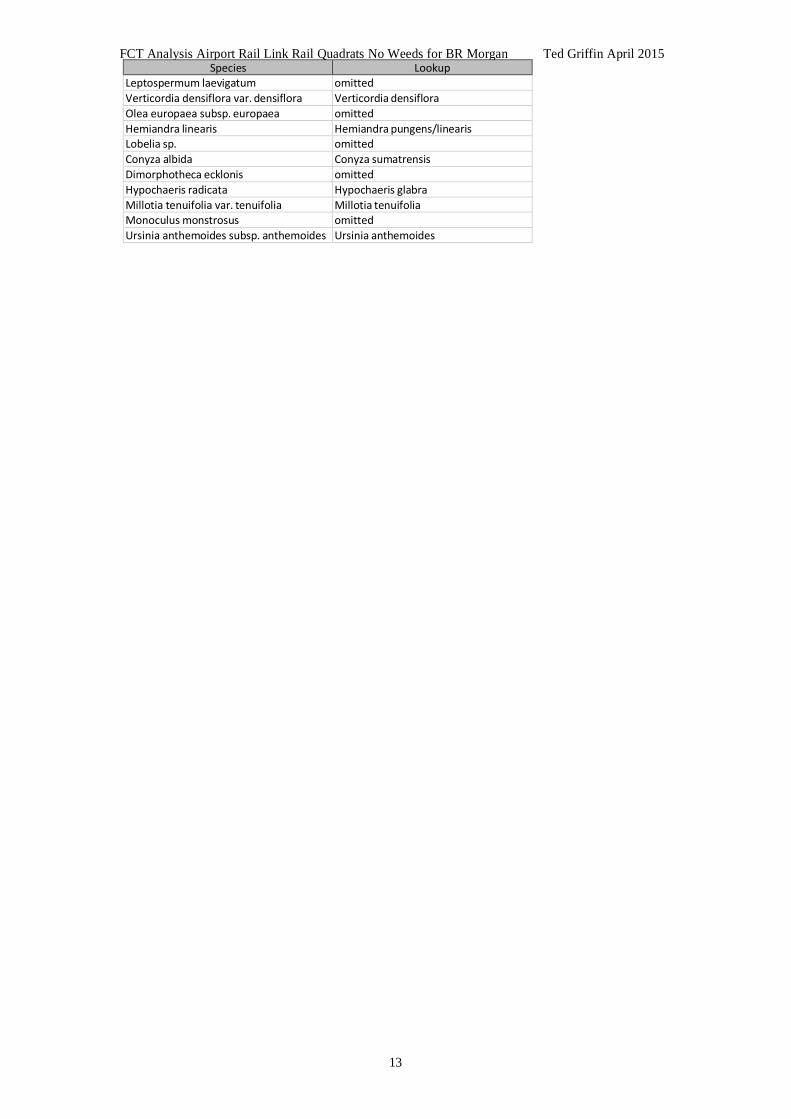
FCT Analysis Airport Rail Link Rail Quadrats No Weeds for BR Morgan Ted Griffin April 2015
13
Species Lookup Leptospermum laevigatum omitted Verticordia densiflora var. densiflora Verticordia densiflora Olea europaea subsp. europaea omitted Hemiandra linearis Hemiandra pungens/linearis Lobelia sp. omitted Conyza albida Conyza sumatrensis Dimorphotheca ecklonis omitted Hypochaeris radicata Hypochaeris glabra Millotia tenuifolia var. tenuifolia Millotia tenuifolia Monoculus monstrosus omitted Ursinia anthemoides subsp. anthemoides Ursinia anthemoides

17
APPENDIX TWO. PATN Analysis: inclusion of supplementary SCP data, weed species removed
Report by Ted Griffin
FCT Supplement Analysis Airport Rail Link Rail Quadrats No Weeds for BR MorganTed Griffin April 2015
1
1.1 INTRODUCTION 1.2 Purpose of this report The current report is intended to help clarify the assignment of Floristic Community type (FCT) designation to vegetation community (site) data. FCTs were defined by Gibson et al (1994) based on site data collected from vegetation on the Swan Coastal Plain. In particular, the potential that a Threatened Ecological Community (English and Blyth 1997) is represented by the data collected needs to be clarified. The Gibson et al (1994) SCP dataset included weed species.
Under Bush Forever (eg Government of Western Australia 2000) 590 additional sites ‘supplementary data’) were considered and allocated to the Gibson et al. (1994) FCTs or to 20 new FCTs that were recognized through the process used. The data from Keighery et al. (2012) was used in this study (Gibson et al. (1994) SCP dataset plus ‘supplementary data’).
This report sought to improve the accuracy of the study site FCT determinations by both including the ‘supplementary data’ and excluding weed species. By including the ‘supplementary data’ in the PATN analysis, the study sites could be compared to many more SCP sites and in particular, many more eastern SCP sites, some of which were local to the study area. Weed species were excluded from the analysis in case the higher number of weed species in the study site quadrats was biasing the FCT allocation. 1.3 Location of Airport Rail Link Sites The sites were from four areas adjacent to Dundas Rd in the area around the Dundas Rd-Maida vale Rd intersection, on the east side of the Kewdale rail freight yards.
1.4 Brief background to floristic analysis of vegetation on the Swan Coastal Plain Floristic analysis (ie., analysis of variation in vegetation based on the species present, rather than description of structural variation and dominance) as a significant component of the understanding of the variation present in the native vegetation of the Swan Coastal Plain dates to Gibson et al (1994 – all references to the SCP survey in the current report refer to this publication), the first publication to document the floristics of the vegetation of a large part of the Swan Coastal Plain. While the SCP survey is based on a very significant amount of work, it must be viewed as a “first pass” survey, limited, in the context of the great variety of vegetation present in the very large area surveyed, by the relatively limited number (509) of sites (quadrats) it is based on. To a limited degree, this limitation has subsequently been addressed in an “update” to the work of the SCP survey (which describes additional units). However, there is no detailed publication of the results of this update available and the additional data used are not readily available in an appropriate form (ie., one that would enable ready comparison of new data to the overall data set).
The units described by the SCP survey are a series of “floristic community types”, a “unit” whose rank is defined by the use within a study. The SCP survey surveyed a very large survey area and defined a relatively small number of floristic community types. Consequently, the floristic community types they have described are of a very high order (see Trudgen 1999, volume 1, for further discussion of this point). This is an extremely important point to fully grasp in interpreting the analysis presented by the SCP survey and in understanding the meaning of analysis of other data sets when they are compared to the floristic community types of the SCP survey.
The important effects of the limited size data set used by the SCP survey and of the

FCT Supplement Analysis Airport Rail Link Rail Quadrats No Weeds for BR MorganTed Griffin April 2015
2
relatively small number of floristic community types defined by them, can be summarized by the following points:
1. the definition of all but six of the Threatened Ecological Communities for
vegetation on the Swan Coastal Plain (DPAW 2014) has been based on the floristic community types of the SCP survey. It therefore follows, that with six exceptions, only vegetation units from one study that are different at a very high order of floristics are treated as rare by Government. No account is taken of other important differences, such as differences in structure and dominance;
2. for the definition of floristic community types to be robust, a sufficient sized
database is needed to give adequate precision in their definition. About half of the floristics community types (or sub types) of the SCP survey are based on less than 10 sites. It is likely that with a larger data set there would be significant alteration in the classification of those floristic community types from the SCP survey based on small numbers of sites.
3. as noted above, many (if not most) of the floristic community types defined by
the SCP survey are very broad. They contain very significant variation in floristics, structure and dominance. Some (or in more highly cleared parts of the Swan Coastal Plain much) of this variation may be rare by any reasonable definition, but it is currently “buried” within larger groups;
4. there is likely to be significant variation not sampled by the SCP survey. This includes some variation at a high level of floristic difference (see Trudgen 1999, volume 1, for an example of this) and undoubtedly quite significant (large!) amounts of variation at “medium” and “low” levels.
5. the document, and its use by Government, has focussed attention in the
environmental impact assessment process on the high level of units described, deflecting attention from the layers of variation beneath these units that also have significant conservation value.
From these points it is obvious that there is a need for a major “upgrade” to the floristic analysis of the vegetation of the Swan Coastal Plain to provide a more detailed floristic classification that considers not only more of the variation present, but explicitly recognises more of the variation present in formally described units.
Obviously, such a reworking would have some effect on what vegetation is considered rare on the Swan Coastal Plain. It needs to be stressed that it would be very unlikely to find that any of the vegetation currently considered to be rare on the basis of the SCP survey’s classification was not rare. On the other hand, it is likely that such a review would very probably consider to be rare some vegetation which is not currently considered rare.
The “supplementary” FCT study was undertaken largely using the PATN module ALOC with the Gibson et al (1994) groups “fixed” and new sites allocated to those if within a user defined tolerance. Any sites “outside” that tolerance were allocated to new FCTs. One limitation of this approach is the presumption that the Gibson el al (1994) FCTs were reasonably well defined. Probably reasonable for where many sites have contributed, but not reasonable where few sites define diverse groups such as wetland FCTs. (More than a sixth of the FCTs had less than five sites and nearly a half had less than 10 sites.)

FCT Supplement Analysis Airport Rail Link Rail Quadrats No Weeds for BR MorganTed Griffin April 2015
3
1.5 Data provided It is very important in comparing different sets of floristic data that they are comparable in the application of names, in the intensity of the survey (ie, the effort of searching resulting in similar proportion of the flora at sites being recorded) and in the size of the site recorded. If the data from different data sets is not comparable in these ways, it reduces the clarity of the results of the analyses carried out. If the discrepancy in the comparability of the data sets is large, the results may become meaningless.
2.1 METHODS 2.2 Data Preparation The data from the Airport Rail Link sites were provided into a standard MS Access based database designed for this type of data. One virtue of the database is that the species recorded at each site are stored against standard codes (numbers, those used by the Western Australian Herbarium) for each species. This facilitates ready comparison of data from different surveys stored in the same system.
After the data were incorporated into the database (containing the data from other projects), a process of reconciliation of flora species names with those used in the SCP survey (Keighery et al 2012) was undertaken. This step was necessary at least because of changes in nomenclature over the last ten years and the potential of survey specific variations in the application of names. The reconciliation involved: • reducing some infra-specific names to the relevant species name, • combining some taxa where confusion is known to have occurred in field
observations and identifications, and • omitting some names (mostly, where a species had only been identified to genus).
The reconciliation process was relatively straight forward as most of the names had already been standardised. Most reconciliation was to conform with the methods that the SCP survey used to manage confusing taxa plus some nomenclatural changes (see Appendix). Weed species were then removed from the combined study area sites and Gibson et al. (1994) dataset.
2.3 Comparability of datasets It was not easy to make any firm conclusions about the compatibility of the data from general summaries.
2.4 Comparisons made The data from the 16 sites plus the 1098 (508 SCP, 590 sup) sites from the SCP survey of the southern part of the Swan Coastal Plain (south of Gingin) (including the ‘supplementary data’) were combined. This enabled various analyses to be performed.
The main purpose was intended to assign the individual sites to the Floristic Community Types (FCTs) defined in the SCP supplementary survey.
These data are provided in BM_Airport.mdb.)
2.5 Analyses carried out The approach was the use of numerical classification techniques (PATN) based on the similarity of the floristic composition of the Airport Rail Link sites to sites in the SCP supplementary survey data set.

FCT Supplement Analysis Airport Rail Link Rail Quadrats No Weeds for BR MorganTed Griffin April 2015
4
2.4.1 PATN Several modules of the numerical classification package PATN (Belbin 1987) were used for the analyses. The parameter values were the same as used by Gibson et al (1994) to ensure consistency of analysis with that study. The ALOC (a non-hierarchal classification use to allocate the supplementary sites to the SCP FCTs and where apparently different from the existing, create new ones) was not used because it is likely that some SCP FCTs were inadequately defined.
The PATN modules used were ASO (calculation of similarity matrix), FUSE (classification based on the results of ASO), DEND (representation of classification) and NNB (determination of sites most similar to each site – nearest neighbours). The results of the analyses were imported into a database (BM_airport.mdb) so that site characteristics and previous classifications (eg. Floristic Community Types derived in earlier classifications) could be associated and various analyses based on these data could be performed.
The assignment of floristic community types to the Airport Rail Link sites was made by summarising the results of two different methods: • the classification (all site classification and ‘single site insertion’ (SSI) classification),
and • the forty nearest neighbours.
Experience demonstrates that the results of these are likely to vary, but that from nearest neighbours is likely to make more sense than the ‘all site’ classification.
To the classification dendrogram of the combined dataset, the FCT assigned by the SCP survey was associated with the SCP survey sites. The apparent FCTs were assigned to the Airport Rail Link sites by interpreting the position of these sites in the dendrogram (particularly by the way they joined to the SCP sites. (FCTs were assigned for the ‘single site insertion’ classifications in the same way, and were considered more powerful than the ‘all site’ classification because SSI is less disruptive to the groupings of the previous classifications.)
The 40 sites in the combined data set that were most similar to each of the Airport Rail Link sites were obtained from the nearest neighbour method (NNB). By associating those nearest neighbours from the SCP survey, the most likely FCTs for each of the Airport Rail Link sites were determined.
An attempt was then made to reconcile these different assignments of a Floristic Community Type.
3.0 LIMITATIONS It has been found in earlier projects that the addition of new sites to the SCP survey data set to produce a combined classification disrupts the original classification. The more data added, the higher the level of the disruption. This problem can make it difficult to assign Floristic Community Types to new sites using this method.
Secondly, it is common for new data to group to their cohorts. In some cases this has proven to result from common deficiencies in the data, ie. whole groups of species missing. This absence tends to draw them together. The more sites in the added batch, the tighter they draw together.

FCT Supplement Analysis Airport Rail Link Rail Quadrats No Weeds for BR MorganTed Griffin April 2015
5
The analyses are conducted without personal knowledge of the sites and no photographs were provided.
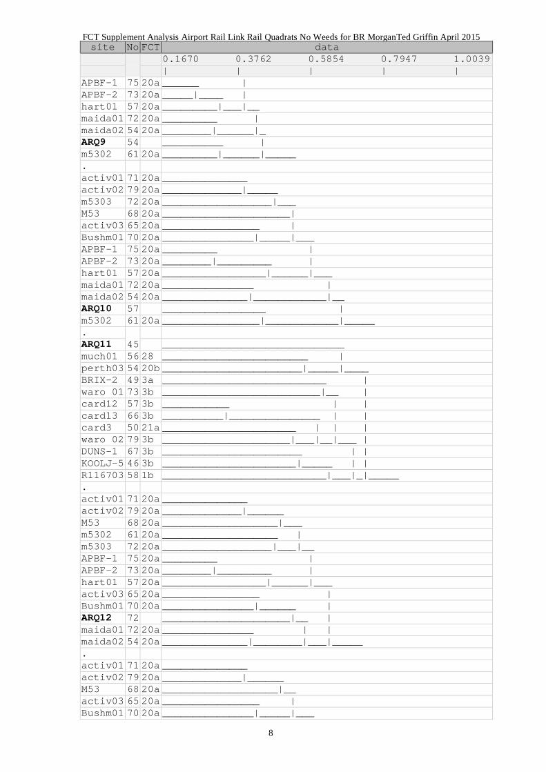
4.1 RESULTS 4.2 Determination of floristic community type by classification The classifications were strongly influenced by the new sites being much more similar to each other than to the SCP sites (Figure 1). Thus, determining the FCT from this classification was impossible.
Figure 1. Relevant portions of Dendrogram
site No FCT data
0.1670 0.3773 0.5877 0.7980 1.0083
| | | | | activ01 71 20a ______________ activ02 79 20a _____________|______ M53 68 20a ___________________|__ activ03 65 20a ________________ | Bushm01 70 20a _______________|_____|__ m5302 61 20a ___________________ | m5303 72 20a __________________|____|_ APBF-1 75 20a _________ | APBF-2 73 20a ________|_________ | hart01 57 20a _________________|______|___ maida01 72 20a _______________ | maida02 54 20a ______________|____________|_________ ARQ1 71 _______ | ARQ4 71 ______|___ | ARQ12 72 _________| | ARQ16 76 ________||___ | ARQ2 77 ____________|____ | ARQ10 57 ________ | | ARQ9 54 _______|___ | | ARQ3 57 __________|_____| | ARQ13 88 _______ || | ARQ15 78 ______|________||_____ | ARQ14 60 _____________________|_ | ARQ11 45 ___________________ | | ARQ5 63 _____________ | | | ARQ6 61 ____________|_____|___|_____________|______ .
ARQ7 25 _____________________________________________ ARQ8 34 ____________________________ | WATER-3 38 3c ________________________ | | yarl01 20 3c _______________________|___|________ | DUCK-1 38 3c ______________ | | DUCK-2 43 3c _____________|__________________ | | ELLEN-6 40 3c _______________________________|___|________|____
(Airport Rail Link quadrats ARQ*)

FCT Supplement Analysis Airport Rail Link Rail Quadrats No Weeds for BR MorganTed Griffin April 2015
6
Figure 2 Relevant portions of Single Site insertion Dendrogram
site No FCT data
0.1670 0.3762 0.5854 0.7947 1.0039
| | | | | activ01 71 20a ______________ activ02 79 20a _____________|______ M53 68 20a ___________________|___ m5302 61 20a ___________________ | m5303 72 20a __________________|___|__ APBF-1 75 20a _________ | APBF-2 73 20a ________|_________ | hart01 57 20a _________________|______|___ activ03 65 20a ________________ | Bushm01 70 20a _______________|______ | ARQ1 71 _____________________|_ | maida01 72 20a _______________ | | maida02 54 20a ______________|_______|____|__________ .
activ01 71 20a ______________ activ02 79 20a _____________|______ M53 68 20a ___________________|___ m5302 61 20a ___________________ | m5303 72 20a __________________|___|__ APBF-1 75 20a _________ | APBF-2 73 20a ________|_________ | hart01 57 20a _________________|______|___ activ03 65 20a ________________ | Bushm01 70 20a _______________|_____ | ARQ2 77 ____________________|___ | maida01 72 20a _______________ | | maida02 54 20a ______________|________|___|__________ .
activ01 71 20a ______________ activ02 79 20a _____________|______ M53 68 20a ___________________|__ activ03 65 20a ________________ | Bushm01 70 20a _______________|_____|__ m5302 61 20a ___________________ | m5303 72 20a __________________|____|__ APBF-1 75 20a _________ | APBF-2 73 20a ________|_________ | hart01 57 20a _________________|_______|__ maida01 72 20a _______________ | maida02 54 20a ______________|____________|__ ARQ3 57 _____________________________|__________ .
activ01 71 20a ______________ activ02 79 20a _____________|______ M53 68 20a ___________________|___ m5302 61 20a ___________________ | m5303 72 20a __________________|___|_ activ03 65 20a ________________ | ARQ4 71 _______________|___ | Bushm01 70 20a __________________|____|__ APBF-1 75 20a _________ | APBF-2 73 20a ________|_________ |

FCT Supplement Analysis Airport Rail Link Rail Quadrats No Weeds for BR MorganTed Griffin April 2015
7
site No FCT data
0.1670 0.3762 0.5854 0.7947 1.0039
| | | | | hart01 57 20a _________________|_______|__ maida01 72 20a _______________ | maida02 54 20a ______________|____________|__________ .
activ01 71 20a ______________ activ02 79 20a _____________|______ M53 68 20a ___________________|__ activ03 65 20a ________________ | Bushm01 70 20a _______________|_____|__ m5302 61 20a ___________________ | m5303 72 20a __________________|____|_ APBF-1 75 20a _________ | APBF-2 73 20a ________|_________ | hart01 57 20a _________________|______|___ maida01 72 20a _______________ | maida02 54 20a ______________|____________|_____ ARQ5 63 __________________________ | YULE-3 53 21c _________________________|______|_____ .
ARQ6 61 ______________________________ YULE-3 53 21c _____________________________|______ Bushm02 32 20c __________________________________ | card11 23 6 _________________________________|_|____ talb10 79 20c ____________ | talb11 50 20c ___________|_______ | talb3 63 20c ________________ | | talb5 61 20c _______________|__|__ | talb7 46 20c ____________________|___ | talb8 73 20c ____________ | | talb9 70 20c ___________|___________|______ | talb2 78 20c ____________________ | | talb6 49 20c ___________________|_________|_________|_ .
ARQ7 25 _____________________________________________ DUCK-1 38 3c ______________ | DUCK-2 43 3c _____________|__________________ | ELLEN-6 40 3c _______________________________|______ | Redh05 24 S15 ___________________________________ | | WATER-3 38 3c ________________________ | | | yarl01 20 3c _______________________|__________|__|______|___ .
ARQ8 34 ____________________________ WATER-3 38 3c ________________________ | yarl01 20 3c _______________________|___|________ DUCK-1 38 3c ______________ | DUCK-2 43 3c _____________|__________________ | ELLEN-6 40 3c _______________________________|___|_____ .
activ01 71 20a ________ activ02 79 20a _______|___ m5303 72 20a __________|__ M53 68 20a ____________| activ03 65 20a __________ | Bushm01 70 20a _________|__|_
FCT Supplement Analysis Airport Rail Link Rail Quadrats No Weeds for BR MorganTed Griffin April 2015
8
site No FCT data
0.1670 0.3762 0.5854 0.7947 1.0039
| | | | | APBF-1 75 20a ______ | APBF-2 73 20a _____|____ | hart01 57 20a _________|___|__ maida01 72 20a _________ | maida02 54 20a ________|______|_ ARQ9 54 __________ | m5302 61 20a _________|______|_____ .
activ01 71 20a ______________ activ02 79 20a _____________|_____ m5303 72 20a __________________|___ M53 68 20a _____________________| activ03 65 20a ________________ | Bushm01 70 20a _______________|_____|___ APBF-1 75 20a _________ | APBF-2 73 20a ________|_________ | hart01 57 20a _________________|______|___ maida01 72 20a _______________ | maida02 54 20a ______________|____________|__ ARQ10 57 _________________ | m5302 61 20a ________________|____________|_____ .
ARQ11 45 ______________________________ much01 56 28 ________________________ | perth03 54 20b _______________________|_____|____ BRIX-2 49 3a ___________________________ | waro 01 73 3b __________________________|__ | card12 57 3b ___________ | | card13 66 3b __________|_______________ | | card3 50 21a ______________________ | | | waro 02 79 3b _____________________|___|__|___ | DUNS-1 67 3b _______________________ | | KOOLJ-5 46 3b ______________________|_____ | | R116703 58 1b ___________________________|___|_|_____ .
activ01 71 20a ______________ activ02 79 20a _____________|______ M53 68 20a ___________________|___ m5302 61 20a ___________________ | m5303 72 20a __________________|___|__ APBF-1 75 20a _________ | APBF-2 73 20a ________|_________ | hart01 57 20a _________________|______|___ activ03 65 20a ________________ | Bushm01 70 20a _______________|______ | ARQ12 72 _____________________|__ | maida01 72 20a _______________ | | maida02 54 20a ______________|________|___|_____ .
activ01 71 20a ______________ activ02 79 20a _____________|______ M53 68 20a ___________________|__ activ03 65 20a ________________ | Bushm01 70 20a _______________|_____|___

FCT Supplement Analysis Airport Rail Link Rail Quadrats No Weeds for BR MorganTed Griffin April 2015
9
site No FCT data
0.1670 0.3762 0.5854 0.7947 1.0039
| | | | | APBF-1 75 20a _________ | APBF-2 73 20a ________|_________ | hart01 57 20a _________________|______|__ ARQ13 88 ______________________ | m5302 61 20a ___________________ | | m5303 72 20a __________________|__|____|_ maida01 72 20a _______________ | maida02 54 20a ______________|____________|_____ .
ARQ14 60 ________________________ card3 50 21a ______________________ | waro 02 79 3b _____________________|_|____ card8 47 20b _________________ | card9 54 20b ________________|__________|_____ .
activ01 71 20a ______________ activ02 79 20a _____________|_____ m5303 72 20a __________________|___ M53 68 20a _____________________| activ03 65 20a ________________ | Bushm01 70 20a _______________|_____|___ APBF-1 75 20a _________ | APBF-2 73 20a ________|_________ | hart01 57 20a _________________|______|___ maida01 72 20a _______________ | maida02 54 20a ______________|____________|_____ ARQ15 78 __________________ | m5302 61 20a _________________|_______ | m5306 62 3a ________________________|____ | xlamb01 95 20b ____________________________|___|_____ .
activ01 71 20a ______________ activ02 79 20a _____________|______ M53 68 20a ___________________|___ m5302 61 20a ___________________ | m5303 72 20a __________________|___|_ activ03 65 20a ________________ | Bushm01 70 20a _______________|______ | ARQ16 76 _____________________|_|__ APBF-1 75 20a _________ | APBF-2 73 20a ________|_________ | hart01 57 20a _________________|_______|___ maida01 72 20a _______________ | maida02 54 20a ______________|_____________|__________ (Airport Rail Link quadrats ARQ*)

FCT Supplement Analysis Airport Rail Link Rail Quadrats No Weeds for BR MorganTed Griffin April 2015
10
4.3 Determination of floristic community type using Nearest Neighbour method The nearest neighbours of a site tends to be its geographically proximal neighbours and sites from its cohort study. Thus, most of the nearest neighbours of the ARQ sites are other ARQ sites. The 10 nearest from the SCP are presented in Table 1. The nearest neighbour analysis suggests that the sites may also belong to related communities. It is interesting that most of the ARQ sites are most similar to active03, a site within 3 km. The majority of the ARQ sites are most similar to those from FCT 20a. This is an FCT localised to the eastern side of the coastal plain (Figure 3).
Table 1. Results of Nearest Neighbour analysis (only SCP sites)
s s1 fct v1 s2 fct v2 s3 fct v3 s4 fct4 v4 s5 fct v5 ARQ1 n_activ03 20a 0.5085 n_m5302 20a 0.5304 n_Bushm01 20a 0.536 n_m5303 20a 0.5433 n_maida02 20a 0.5495 ARQ2 n_activ03 20a 0.4876 n_m5302 20a 0.5085 s_talb9 20c 0.5276 n_Bushm01 20a 0.5313 n_maida01 20a 0.5504 ARQ3 n_activ03 20a 0.5385 n_m5302 20a 0.5446 n_activ02 20a 0.5763 s_card3 21a 0.587 s_talb5 20c 0.6 ARQ4 n_activ03 20a 0.431 n_m5302 20a 0.4867 n_Bushm01 20a 0.5122 n_Cresw01 23a 0.5185 s_card3 21a 0.5192 ARQ5 n_activ03 20a 0.514 n_hart01 20a 0.5769 n_maida02 20a 0.58 n_Cresw01 23a 0.596 n_maida01 20a 0.6 ARQ6 n_activ03 20a 0.5327 n_leda02 28 0.5922 s_KING-2 28 0.5955 s_waro 02 3b 0.6134 s_BULLER-1 21a 0.6304 ARQ7 s_yarl01 3c 0.7241 s_WELL-1 21a 0.7778 n_bold17 S15 0.7778 n_much04 25 0.8 s_rowe01 11 0.8095 ARQ8 s_WATER-3 3c 0.6154 n_bold17 S15 0.641 s_card1 20b 0.6471 s_card12 3b 0.6486 s_yarl01 3c 0.6585 ARQ9 n_m5302 20a 0.46 n_activ03 20a 0.4757 s_card3 21a 0.5385 s_talb9 20c 0.5413 s_M53 20a 0.5856 ARQ10 n_m5302 20a 0.4476 n_activ03 20a 0.5185 s_card3 21a 0.5625 s_M53 20a 0.569 s_talb9 20c 0.5789 ARQ11 n_activ03 20a 0.4845 n_perth03 20b 0.5862 s_card12 3b 0.6136 s_card1 20b 0.6162 n_m5302 20a 0.617 ARQ12 n_activ03 20a 0.469 n_m5302 20a 0.5091 n_perth08 23a 0.5192 s_card3 21a 0.5446 s_M53 20a 0.5537 ARQ13 n_m5302 20a 0.4884 s_talb2 20c 0.5245 n_activ03 20a 0.5303 n_m5306 3a 0.552 n_maida01 20a 0.5571 ARQ14 s_card3 21a 0.5464 n_activ03 20a 0.5596 n_m5302 20a 0.566 s_waro 02 3b 0.5702 s_M53 20a 0.5726 ARQ15 n_m5302 20a 0.459 n_activ03 20a 0.504 s_card13 3b 0.52 n_perth03 20b 0.5304 s_talb9 20c 0.542 ARQ16 n_activ03 20a 0.479 n_Cresw01 23a 0.5135 n_m5302 20a 0.5172 n_Kens01 23a 0.5424 n_m5303 20a 0.5469
s s6 fct6 v6 s7 fct v7 s8 fct v8 s9 fct v9 s10 fct v10 ARQ1 s_M53 20a 0.555 n_maida01 20a 0.555 n_Cresw01 23a 0.563 n_perth04 23a 0.569 s_YULE-3 21c 0.570 ARQ2 n_m5303 20a 0.553 s_talb2 20c 0.560 n_perth04 23a 0.563 n_perth03 20b 0.567 s_talb8 20c 0.572 ARQ3 s_M53 20a 0.607 s_talb9 20c 0.618 n_perth08 23a 0.621 n_Bushm01 20a 0.621 s_talb7 20c 0.623 ARQ4 s_M53 20a 0.548 s_card5 20b 0.55 n_activ02 20a 0.553 s_waro 02 3b 0.562 s_BULLER-1 21a 0.564 ARQ5 n_activ02 20a 0.603 n_m5303 20a 0.603 n_Kens01 23a 0.603 s_YULE-3 21c 0.604 n_Bushm0 20a 0.614 ARQ6 n_MGK03 21b 0.642 s_card12 3b 0.653 s_yarl03 3b 0.653 s_WIRR-2 23a 0.654 n_Cresw01 23a 0.656 ARQ7 s_low06b 21c 0.811 n_vines01 25 0.818 n_leda02 28 0.820 s_TRIG-4 28 0.822 s_CRAMPT-2 21a 0.823 ARQ8 n_perth03 20b 0.671 s_yarl03 3b 0.675 s_SHENT-1 28 0.689 s_BULL-1 28 0.690 s_BULL-9 28 0.692 ARQ9 n_m5303 20a 0.589 s_BULLER-1 21a 0.590 n_dian01 23a 0.592 s_card13 3b 0.592 n_perth08 23a 0.595 ARQ10 n_Kens01 23a 0.588 n_m5303 20a 0.589 s_TWIN-8 21c 0.595 n_MGK03 21b 0.604 s_talb11 20c 0.604 ARQ11 n_maida02 20a 0.622 s_card13 3b 0.628 n_maida01 20a 0.638 n_hart01 20a 0.638 s_KOOLJ-5 3b 0.641 ARQ12 n_Cresw01 23a 0.561 n_perth04 23a 0.567 n_Bushm01 20a 0.583 s_low06a 21c 0.587 n_perth03 20b 0.592 ARQ13 n_m5303 20a 0.560 s_talb9 20c 0.565 s_FL-1 4 0.575 s_card13 3b 0.575 s_waro 02 3b 0.583 ARQ14 n_wire01 28 0.572 s_TWIN-8 21c 0.576 s_talb9 20c 0.582 s_CRAMPT-2 21a 0.584 s_REDL-1 21a 0.589 ARQ15 n_m5306 3a 0.542 s_card12 3b 0.551 s_card3 21a 0.557 s_card1 20b 0.559 n_maida01 20a 0.578 ARQ16 s_card3 21a 0.551 s_AUSTRA-1 21a 0.570 s_low06a 21c 0.571 n_Bushm01 20a 0.571 s_M53 20a 0.574
Columns s – the site being compared s1 to s10 – the 1st to 10th most similar sites (prefix ‘s’ original SCP sites, ‘n’ supplement sites)
f1 to f10 – the FCT of the similar sites (only for SCP sites) v1 to v10 – the dissimilarity value between the site and the similar sites (values above 0.6 tend to indicate low similarity)

FCT Supplement Analysis Airport Rail Link Rail Quadrats No Weeds for BR MorganTed Griffin April 2015
11
Figure 3 Distribution of ARQ sites (blue) with FCT 20a sites (white).

FCT Supplement Analysis Airport Rail Link Rail Quadrats No Weeds for BR MorganTed Griffin April 2015
12
4.4 Combining the results It is common for the classification to indicate a simple result and the nearest neighbour analysis to be less conclusive. This is more a product of the classification process often suggesting an over simplified view than of inconsistency of the analyses.
It is important to appreciate that classification cannot be absolute; evidence for which is that when new sites are added to an analysis set some clusters can change. It remains to be demonstrated to what degree a new site should belong to an existing community even if it is quite similar to one or more members of another community. But commonly a new site is quite similar to more than one existing community.
Table 2 Summary of results Site Dendrogram FCT NNB FCT SSI FCT Recommend to Consider ARQ1 20a 20a 20a 20a ARQ2 20a 20a 20a 20a ARQ3 20a 20a 20a 20a ARQ4 20a 20a 20a 20a ARQ5 20a 20a 21c/20a 20a/21c ARQ6 20a 20a 21c/20c 20a/20c/21c ARQ7 3c ??3c 3c ??3c ARQ8 3c ?3c 3c ?3c ARQ9 20a 20a 20a 20a ARQ10 20a 20a 20a 20a ARQ11 20a 20a 20b/28/3b 20a/20b ARQ12 20a 20a 20a 20a ARQ13 20a 20a/?20c 20a 20a ARQ14 20a 21a/20a 21a/3b/20b 20a/21a ARQ15 20a 20a 20a 20a ARQ16 20a 20a 20a 20a
For the most part, the Single Site insertion is consistent with the nearest neighbor inferences. The FCT recommended to consider are largely from Single Site insertion.
FCT Supplement Analysis Airport Rail Link Rail Quadrats No Weeds for BR MorganTed Griffin April 2015
13
4.0 REFERENCES
Belbin, L. (1987) PATN Reference Manual (313p), Users Guide (79p), Command Manual (47p), and Example Manual (108p). CSIRO Division of Wildlife and Ecology, Lynham, ACT.
DPAW (2014) http://www.dpaw.wa.gov.au/images/documents/plants-animals/threatened-
species/tecs/Threatened_ecological_communities_endorsed_by_the_Minister_for_Environment_May2014.pdf
English, V., and Blyth, J. (1997) Identifying and conserving threatened ecological
communities (TECs) in the South West Botanical Province. ANCA National Reserves System Cooperative Program: Project Number N702, Australian National Conservation Agency, Canberra
Government of Western Australia (2000). Bush Forever: Keeping the Bush in the City.
Volume 2:.Directory of Bush Forever Sites. Department of Environmental Protection, Perth Western Australia
Gibson, N.G., Keighery, B.J., Keighery, G.J., Burbidge, A.H. and Lyons, M (1994). A
Floristic Survey of the Southern Swan Coastal Plain. Unpublished report by the Department of Conservation and Land Management and the Conservation Council of Western Australia to the Australian Heritage Commission.
Keighery, B., Keighery, G., Longman, V.M., and Clarke, K.A. 2012. Data compiled
for the Departments of Environmental Protection and Conservation and Land Management.
Trudgen, M.E. (1999). A flora and vegetation survey of Lots 46 and 47 Maralla Road
and Lexia Avenue, Ellenbrook. Volumes 1-4. Unpublished report prepared for the Crown Solicitors Office, Government of Western Australia. December 1999.

FCT Supplement Analysis Airport Rail Link Rail Quadrats No Weeds for BR MorganTed Griffin April 2015
14
5.0 APPENDIX
Appendix 1 Species combinations made to assist in reconciling taxonomic changes and identification difficulties between this survey and SCP supplementary data. FAMILY Species_LUP.name Species_LUP_1.name Anarthriaceae Lyginia imberbis Lyginia barbata Apiaceae Xanthosia huegelii Xanthosia huegelii subsp. huegelii Asparagaceae Thysanotus manglesianus Thysanotus manglesianus/patersonii complex Asparagaceae Thysanotus manglesianus/patersonii Thysanotus manglesianus/patersonii complex Asparagaceae Thysanotus patersonii Thysanotus manglesianus/patersonii complex Brassicaceae Raphanus raphanistrum omitted Campanulaceae Lobelia sp. omitted Cyperaceae Lepidosperma aff. pubisquameum Lepidosperma angustatum/squamatum Cyperaceae Lepidosperma pubisquameum 'flat form' Lepidosperma angustatum/squamatum Cyperaceae Lepidosperma squamatum Lepidosperma angustatum/squamatum Cyperaceae Schoenus caespititius Schoenus brevisetis Cyperaceae Schoenus sp. omitted Droseraceae Drosera porrecta Drosera stolonifera subsp. porrecta Droseraceae Drosera porrecta Drosera stolonifera subsp. porrecta Euphorbiaceae Monotaxis grandiflora var. grandiflora Monotaxis grandiflora Fabaceae Acacia lasiocarpa var. lasiocarpa Acacia lasiocarpa Fabaceae Acacia pulchella var. glaberrima Acacia pulchella Fabaceae Acacia pulchella var. pulchella Acacia pulchella Fabaceae Daviesia decurrens Daviesia decurrens subsp. decurrens Fabaceae Gompholobium glutinosum Gompholobium aristatum Fabaceae Hovea trisperma Hovea trisperma var. trisperma Fabaceae Templetonia biloba Cristonia biloba Fabaceae Vicia sativa subsp. sativa Vicia sativa Haemodoraceae Conostylis aculeata subsp. aculeata Conostylis aculeata Haemodoraceae Conostylis aculeata subsp. breviflora Conostylis aculeata Haemodoraceae Conostylis aculeata subsp. bromelioides Conostylis aculeata Haemodoraceae Conostylis aculeata subsp. cygnorum Conostylis aculeata Haemodoraceae Conostylis aculeata subsp. preissii Conostylis aculeata Hemerocallidaceae Johnsonia pubescens Johnsonia pubescens subsp. pubescens Iridaceae Patersonia occidentalis var. occidentalis Patersonia occidentalis Juncaginaceae Triglochin nana Triglochin centrocarpum Lamiaceae Hemiandra linearis Hemiandra pungens/linearis Lamiaceae Hemiandra pungens Hemiandra pungens/linearis Moraceae Ficus carica omitted Myrtaceae Baeckea camphorosmae Babingtonia camphorosmae Myrtaceae Eremaea asterocarpa subsp. asterocarpa Eremaea asterocarpa Myrtaceae Eucalyptus calophylla Corymbia calophylla Myrtaceae Eucalyptus marginata Eucalyptus marginata subsp. marginata Myrtaceae Verticordia densiflora Verticordia densiflora var. densiflora Myrtaceae Verticordia plumosa var. brachyphylla Verticordia plumosa Myrtaceae Verticordia plumosa var. pleiobotrya Verticordia plumosa Myrtaceae Verticordia plumosa var. vassensis Verticordia plumosa Onagraceae Epilobium billardiereanum subsp. billardiereanum Epilobium billardiereanum Onagraceae Epilobium billardiereanum subsp. intermedium Epilobium billardiereanum Orchidaceae Caladenia longicauda subsp. albella Caladenia longicauda Orchidaceae Caladenia longicauda subsp. calcigena Caladenia longicauda Orchidaceae Caladenia longicauda subsp. longicauda Caladenia longicauda Orchidaceae Caladenia sp. omitted Orchidaceae Microtis media subsp. media Microtis media Orchidaceae Pterostylis sp. omitted Orchidaceae Thelymitra graminea Thelymitra macrophylla Pittosporaceae Billardiera fraseri Pronaya fraseri Plantaginaceae Veronica sp. omitted Poaceae Pentameris airoides subsp. airoides Pentaschistis airoides/pallida Poaceae Pentaschistis airoides Pentaschistis airoides/pallida Poaceae Pentaschistis pallida Pentaschistis airoides/pallida Poaceae Pentaschistis sp. scps Pentaschistis airoides/pallida Poaceae Rytidosperma occidentale Austrodanthonia occidentalis Proteaceae Banksia dallanneyi var. dallanneyi Dryandra lindleyana

FCT Supplement Analysis Airport Rail Link Rail Quadrats No Weeds for BR MorganTed Griffin April 2015
15
FAMILY Species_LUP.name Species_LUP_1.name Proteaceae Grevillea bipinnatifida subsp. bipinnatifida Grevillea bipinnatifida Proteaceae Grevillea sp. omitted Proteaceae Synaphea petiolaris Synaphea petiolaris subsp. petiolaris Restionaceae Lepyrodia sp. omitted Rhamnaceae Trymalium odoratissimum subsp. odoratissimum Trymalium floribundum Rutaceae Boronia ramosa subsp. anethifolia Boronia ramosa Rutaceae Boronia ramosa subsp. ramosa Boronia ramosa Scrophulariaceae Eremophila glabra subsp. albicans Eremophila glabra Scrophulariaceae Verbascum sp. scsp omitted