forests and trees - national park service · parks as classrooms forests and trees ... type...
TRANSCRIPT

Parks as Classrooms Forests and Trees �
Unit RationaleGreat Smoky Mountains National Park offers examples of relationships in its forest, geology, and ecosystems. Students can observe patterns in life (forest growth) as well as death (forest decomposition).The Carlos Campbell Overlook provides students with a picture of forest types and the patterns of geology typical of the park. Among the ridges and valleys students can see Cove hardwood, Northern hardwood, Spruce-Fir, Hemlock, and Pine-Oaks. Heath-balds can also be observed from this point.The Appalachian Trail can be utilized to examine patterns in nature in a variety of ways. Climatic and forest type differences can be observed with the gaps beginning cooler and wetter hosting hardwood trees and the nearby ridge tops beginning warmer and dryer providing more habitat for coniferous forests. Patterns of growth and reproduction of trees and other plants can be examined.
Forests and trees
Theme: History and ForestsGrade Level: FourthBest Time to Plan Trip: Fall
State Education StandardsTennessee
ScienceInterdependence GLE 0407.2.� Analyze the effects of changes in the environment on the stability of an ecosystem.
Flow of Matter and Energy GLE 0407.3.� Demonstrate that plants require light energy to grow and survive.GLE 0407.3.2 Investigate different ways that organisms meet their energy needs.
//2009// standards

Parks as Classrooms Forests and Trees 2
Unit Rationale .......................................................................................... �State Learning Standards ........................................................................ 2Planning Your Trip ................................................................................. 4Safety Considerations and Other Important Information ............... 5
Pre-Site ActivitiesPre-test ...................................................................................................... 6Pre-test Teacher Key............................................................................... 7Name that Tree ........................................................................................ 8
On-Site ActivitiesA Hike Along Indian Gap Trail ............................................................ 9Soil Study .................................................................................................. ��Forest Types and Landforms ................................................................ �3
Post-Site ActivitiesChestnut Blight Game ............................................................................ �5Decomposing Logs ................................................................................. �4Explore Your National Parks ................................................................ �6
AppendixPark Essentials to Know Before You Go ........................................... �7What to Carry/ How to Pack for Your Trip....................................... �9Resources and References ...................................................................... 20
table oF Contents
Activity Page

Parks as Classrooms Forests and Trees 3
Planning a Successful Trip•Check the weather before you go. The �.7 mile hike from Indian Gap trail to Newfound Gap parking area is in a high elevation forest.
•There is parking for school busses at both the Newfound Gap parking are and the Indian Gap trail. Be sure your bus driver knows to drop you off at the Indian Gap trail head and then pick your group back up at Newfound Gap. The �.7 hike takes approximately one hour. It is safest to visit the Carlos Campbell overlook on the way down highway 44� after your visit to the Chimneys picnic area. Be sure to use your turn signal and be aware of the location of the pull off.
•Plenty of chaperones are recommended for the purposes of supervision on the trail. We recommend that for the purposes of safety, one adult should be available for every eight students. On the hike in particular, one adult must act as the sweep at the back of the group while several adults act as leaders for each sub-group.
Planning a suCCessFul triPForests and trees
Schedule for a day of activities in Great Smoky Mountains National Park
Travel to Newfound Gap for restrooms Arrive at Indian Gap TrailComplete �.7 mile hikeUse restrooms at Newfound GapTravel to Chimneys Picnic area for lunchConduct soil and decomposition searchVisit Carlos Campbell OverlookReturn to School
3

Parks as Classrooms Forests and Trees 4
Forests and treessaFety Considerations and other imPortant inFormation
•Park Rules and RegulationsGreat Smoky Mountains National Park is a federally protected public use area. Certain activities are prohibited by visitors. Be sure to read the rules and regulations of the National Park found in the appendix of this lesson. For further information or questions, you may contact the National Park at 865-436-�7�3. Please use common sense and appropriate planning whenever you participate in outdoor activities.
•Dressing for the WeatherPlease remind your students to wear appropriate footwear and clothing for an extended outdoor program. Short pants, flip flops, or sandals aren’t recommended. Temperatures in the mountains can be �0-�5 degrees colder than at your school. You may wish to alter portions of the program should inclement weather appear.
•Restrooms and WaterRestrooms and seasonal water fountains are located at the Sugarlands Visitor Center as well as Newfound Gap overlook and parking area.
•Packing LunchesLunches may be eaten at the Newfound Gap parking area, but we suggest traveling back down the mountain to the Chimneys Picnic Area. For ease of planning and for safety, teachers may wish to pack lunches and drinks in coolers and keep them on the bus until lunch. Outdoor grills are available at each picnic site in the Chimneys picnic area. If you decide to grill out, NEVER leave food unattended.
•Group SizeThe location and parking lot oat this area can accommodate a large group (several classes). For safety and enjoyment of the trail, we recommend a maximum group size of 60 students.
•Cell Phones and Emergency ContactsWithin the National Park, cell phones are not always reliable. Be sure to stick to your agenda. Certain cell phones will pick up at the Newfound Gap parking area or clear overlooks. In case of emergency call 9��. For non-emergencies, contact Park Rangers at 865-436-�294. Again, if you do not have phone reception, contact the nearest park employee and they can assist using the park’s radio communication system.
4

Parks as Classrooms Forests and Trees 5
Forests and Trees of the Smokies Name: ___________________ 4th Grade Indian Gap/Chimney’s Picnic Area 1.Who was Carlos Campbell?
2.Name 3 forest types found in Great Smoky Mountains National Park.
3.Which forest type is found at the highest elevation?
4.Name 3 organisms that might be found living in or growing on a decomposing log.
5.Name one native tree found in the Park that has simple leaves?
6.Name one native tree found in the Park that has compound leaves?
7.Name one tree that might be dominant in a Cove Hardwood Forest.
8.One of the most important creatures in the decomposition process is__________.
9.Which high elevation, evergreen tree has short, stiff needles that feel prickly?
10. The __________________ ________________ tree was once considered the queen of Eastern Forest until it was virtually wiped-out by a fungus from Asia. Animals depended on its nuts and settlers used the wood for homes and furniture.
11.Why do millions of people visit Great Smoky Mountains National Park in the fall?
What is your favorite tree? Why?
Pre-site testPre Score:_______Post Score:______

Parks as Classrooms Forests and Trees 6
Forests and Trees of the Smokies Unit 4th Grade Indian Gap/Chimney’s Picnic Area
1.Who was Carlos Campbell?A naturalist, photographer, and author who fought for the establishment of GSMNP
2.Name 3 forest types found in Great Smoky Mountains National Park.Cove Hardwood, Hemlock, Oak-Pine, Spruce-fir, Northern Hardwood
3.Which forest type is found at the highest elevation?Spruce-fir
4.Name 3 organisms that might be found living in or growing on a decomposing log.Worms, sowbugs, bacteria, centipede, milipedes, moss, fungus, etc.
5.Name one native tree found in the Park that has simple leaves?Oak, Maple, Dogwood, Tulip Poplar and many others
6.Name one native tree found in the Park that has compound leaves?Walnut, Ash and Many others
7.Name one tree that might be dominant in a Cove Hardwood Forest.Beech, Maple, and Oak to name a few.
8.One of the most important creatures in the decomposition process is_______________.Earthworm
9. Which high elevation, evergreen tree has short, stiff needles that feel prickly? Spruce
10.The _______American Chestnut___________ tree was once considered the queen of Eastern Forest until it was virtually wiped-out by a fungus from Asia.
11.Why do millions of people visit Great Smoky Mountains National Park in the fall?To see the leaves changeWhat is your favorite tree? Why?Almost any answer is correct
(Teachers: Administer this test once before teaching the pre-visit activities and once after the post site activities for comparable results of comprehension and retention )
Pre-site test

Parks as Classrooms Forests and Trees 7
Pre-site aCtivityname that tree
The Smokies are home to over �20 different species of trees. To expect anyone to learn to identify all of them without aid of a guide or key is unrealistic. This activity will help to narrow the student’s focus in the study of trees to assist them on their trip to the park.
Tell students that they will play a game that helps them learn a few of the trees in the Park. Divide students into two teams. Assign a score keeper for each team. Have the two teams line up in a row and face each other. Have each team count off, so that each child has a number between � and 9. Arrange 9 different leaf cards in a row in the center of the 2 teams. Call the name of a tree species represented on one of the leaf cards. Call out a number between � and 9. The two students with this number compete to be the first one to find the correct leaf. Whoever gets the leaf first wins a point for his or her team. Call out several more tree species until each pair of students has had at least one turn. The team with the most points wins the game. You can make it more challenging by subtracting a point each time a team member selects the wrong tree species.
Leaf key for the following pages:p. 8 Dogwood p. �5 Hickoryp. 9 Oak p. �6 Hemlockp. �0 Red Budp. �� Tulip Treep. �2 Magnoliap.�3 Sasafrassp.�4 Buckeye
7
Duration: 30 minutes Class Size: anyMaterials: Leaf Silhouettes on 8x�� pages (oak, tulip poplar, hemlock, sycamore, maple, hickory, sweetgum, holly, beech, redbud)

Parks as Classrooms Forests and Trees 8

Parks as Classrooms Forests and Trees 9

Parks as Classrooms Forests and Trees �0

Parks as Classrooms Forests and Trees ��

Parks as Classrooms Forests and Trees �2

Parks as Classrooms Forests and Trees �3

Parks as Classrooms Forests and Trees �4

Parks as Classrooms Forests and Trees �5

Parks as Classrooms Forests and Trees �6

Parks as Classrooms Forests and Trees �7
on-site aCtivitya hike along indian gaP trail
Information for the TeacherIndian Gap Trail Length (�.7 miles)Bus Driver should drop students off at the trail head for Indian gap along Clingmans Dome Road. The students and adults will hike back to Newfound Gap Overlook where the bus will be waiting. Use extreme caution when crossing back in to the Newfound Gap parking lot.
Adults must keep track of the entire group assigned to them. Never walk faster than your slowest hiker.
Cell phones may not be reliable on this portion of the trip. Short wave walkie talkies are suggested, or simply carrying a whistle is a good safety measure. Coordinate a plan for communication if there is a safety situation (a slow walker, trip or fall, etc).
Directions for This ActivityAsk students how Indian Gap looks/feels different than where they began their day (colder, windier, spruce-fir trees, wetter). Tell students how Indian Gap was named. (Indian Gap was thought to be the lowest gap through the mountains from NC to TN. A road was built in �839 and used until Newfound Gap was discovered. The unpaved, rocky road went through this gap that was used by traders, farmers, and even the Confederate Army. The road was named after the old Cherokee Indian trail which parallels the road.)
Tell students that as they hike to Newfound Gap, they will be looking for the items on their data sheet. Students should hike in small groups (ideally �0 or fewer) with a teacher or adult volunteer. Allow
some space between each group. The teacher/volunteer should stop several times along the trail and explain items on the data sheet. (nurse trees, chestnut stumps, beech gap, etc.) Students will complete data sheet.
Duration: 90 minutesClass Size: 30 -50 in sub groupsMaterials: Data Sheets (provided)

Parks as Classrooms Forests and Trees �8
Fraser Fir Evergreen, 2 rows of needles with rounded tips and white band underneath; bark is gray or brown with many resin blisters
Red Spruce
Evergreen, needles are stiff, 4 angled and sharp pointed; bark is reddish brown and scaly.
Mountain Maple Small tree with large leaves with short 3-5 broad lobes and hairy beneath.
Yellow Birch Leaves are elliptical and sharply saw- toothed turn-ing yellow in the fall; bark is silvery with paper curly strips.
American Beech Leaves are elliptical and sharply saw- toothed turning copper brown in the fall; buds are cigar-shaped; bark is smooth and gray.
Eastern Hemlock
Evergreen, needles are flat and round at the tip with two whitish bands beneath; bark is cinnamon brown, thick and deeply furrowed
Rhododendron Evergreen shrub; leaves large, elliptical, thick and dark shiny green.
Fern
Ground Pine
Moss
Mushroom
Nurse Log
Prop Tree
Shallow Root System
As you see the following items, write three words to describe them. (Example: Dead Tree- rotting, dark brown, smelly)
Indian Gap Trail Hike Checklist
Put a check in the box when you find the tree.

Parks as Classrooms Forests and Trees �9
Directions for this Activity:Ask students what happens to trees when they die. (trees will be decomposed my parts of the forest community, some become “nurse trees”, dead trees create soil nutrients) Ask students what helps decomposition occur. (weather, fungi, insects, earthworms, bacteria) Tell students that you are going to more closely examine decomposing logs and see if you can identify some decomposers. Have students work in teams to collect data about the numbers and kinds of decomposers. Use the worksheet on the following page to complete this assignment. Students should work in small groups with an adult. Groups should never be allowed to explore on their own. Adults must be familiar with poison ivy (a three leaved plant and vine), as well as use caution and identify other potential hazards.
Remind Students: When investigating under a log or a rock, do NOT lift the log or rock up directly in front of you. Instead, approach it from the back and have another student look. If you do see a live animal, DO NOT PICK IT UP. Gently place the log or rock back into it’s exact placement without crushing the organism (this will prevent any loss of moisture from the microhabitat).
on site aCtivitysoil study
Location: Chimneys Picnic ArealDuration: 20 minutesClass Size: 30 - 50 students in small groupsMaterials: Data Sheets (provided)

Parks as Classrooms Forests and Trees 20
Organism TallyEarthworms
Snail or Slug
Insect (6 Legs)
Spiders or Mites (8 Legs)
Millipedes and Centipedes
Larval Insects
Salamanders
Other
Chimney’s Picnic Area Decomposer Search
When you find something under leaves or a fallen log, mark it in the proper space
Parks as Classrooms Forests and Trees 2�
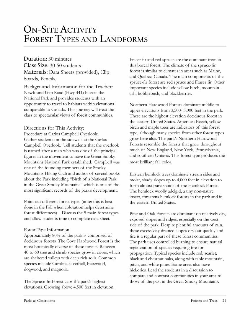
on-site aCtivityForest tyPes and landForms
Background Information for the Teacher:Newfound Gap Road (Hwy 44�) bisects the National Park and provides students with an opportunity to travel to habitats within elevations comparable to Canada. This journey will treat the class to spectacular views of forest communities.
Directions for This Activity:Procedure at Carlos Campbell Overlook: Gather students on the sidewalk at the Carlos Campbell Overlook. Tell students that the overlook is named after a man who was one of the principal figures in the movement to have the Great Smoky Mountains National Park established. Campbell was one of the founding members of the Smoky Mountains Hiking Club and author of several books about the Park including “Birth of a National Park in the Great Smoky Mountains” which is one of the most significant records of the park’s development.
Point out different forest types (note: this is best done in the Fall when coloration helps determine forest differences). Discuss the 5 main forest types and allow students time to complete data sheet.
Forest Type InformationApproximately 80% of the park is comprised of deciduous forests. The Cove Hardwood Forest is the most botanically diverse of these forests. Between 40 to 60 tree and shrub species grow in coves, which are sheltered valleys with deep rich soils. Common species include Carolina silverbell, basswood, dogwood, and magnolia.
The Spruce-fir Forest caps the park’s highest elevations. Growing above 4,500 feet in elevation,
Fraser fir and red spruce are the dominant trees in this boreal forest. The climate of the spruce-fir forest is similar to climates in areas such as Maine, and Quebec, Canada. The main components of the spruce-fir forest are red spruce and Fraser fir. Other important species include yellow birch, mountain-ash, hobblebush, and blackberries.
Northern Hardwood Forests dominate middle to upper elevations from 3,500- 5,000 feet in the park. These are the highest elevation deciduous forest in the eastern United States. American Beech, yellow birch and maple trees are indicators of this forest type, although many species from other forest types grow here also. The park’s Northern Hardwood Forests resemble the forests that grow throughout much of New England, New York, Pennsylvania, and southern Ontario. This forest type produces the most brilliant fall color.
Eastern hemlock trees dominate stream sides and moist, shady slopes up to 4,000 feet in elevation to form almost pure stands of the Hemlock Forest. The hemlock woolly adelgid, a tiny non-native insect, threatens hemlock forests in the park and in the eastern United States.
Pine-and-Oak Forests are dominant on relatively dry, exposed slopes and ridges, especially on the west side of the park. Despite plentiful amounts of rain, these excessively drained slopes dry out quickly and fire is a regular part of these forest communities. The park uses controlled burning to ensure natural regeneration of species requiring fire for propagation. Typical species include red, scarlet, black and chestnut oaks, along with table mountain, pitch, and white pines. Some areas also have hickories. Lead the students in a discussion to compare and contrast communities in your area to those of the past in the Great Smoky Mountains.
Duration: 30 minutes Class Size: 30-50 studentsMaterials: Data Sheets (provided), Clip boards, Pencils,
Parks as Classrooms Forests and Trees 22
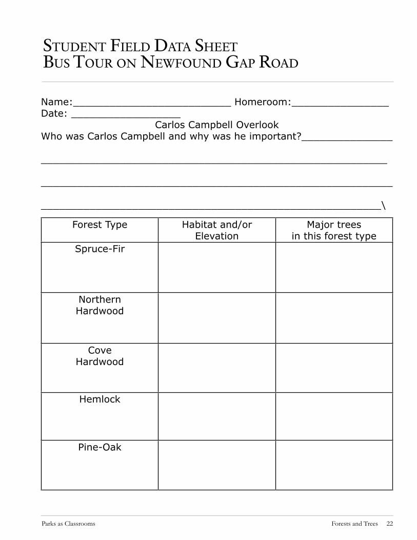
student Field data sheetbus tour on newFound gaP road
Forest Type Habitat and/or Elevation
Major trees in this forest type
Spruce-Fir
Northern Hardwood
CoveHardwood
Hemlock
Pine-Oak
Name:__________________________ Homeroom:________________Date: __________________
Carlos Campbell OverlookWho was Carlos Campbell and why was he important?_______________
_________________________________________________________
__________________________________________________________
________________________________________________________\
Parks as Classrooms Forests and Trees 23
Post-site aCtivityChestnut blight game
Background Information for the TeacherOnce a giant in the forests of the Eastern US , the American Chestnut tree contributed to 25 % of the forest community. This tree was not only an economic resource for loggers in pre-park days- being a light-weight wood in massive size and extremely rot-resistant, but it had been a major food source for nut consuming animals. An imported “blight” or airborne fungus from Asia killed all of the seed producing Chestnut Trees in the early 1900’s. The following activity will illustrate the demise of this ecological treasure.
Directions for this Activity�. Students divide into 2 large groups: one group becomes the chestnut blight and the other group is chestnut trees.2. The two groups will form lines that face each other about 30 ft apart. The blight group is given 3 balls (which represent the blight being stronger than the trees resistance); the tree group is given only � ball. Balls should be small enough to fit in the palm of a students hand and rather soft. Water balls work well and can be slightly damp. 3. The groups are asked to turn around and secretly hand the balls to their some of their players so that the other group does not know who has the balls.4. When the teacher says “go” the two groups turn back around to face each other and try to hit members of the opposite team with the ball. Naturally the blight group will hit more trees than tree group. Team members that are struck with a ball must go to the opposite team. If a tree team member hits a blight team member it means that the tree was genetically resistant to the blight and was
able to reproduce.5. Play at least 5 rounds. Eventually all the trees will be overcome by blight.6. Ask one student to keep a chart of the number of trees that died each year (represents each round).
Review:Despite the damage the blight causes, non-profit foundations are studying issue and determined to cultivate trees which show resistance to the fungus. One such group - the American Chestnut Foundation cultivated blight resistant Chestnuts in 2005 and hopes to further the reestablishment of American Chestnuts in the wild.
Duration: 30 minutes Class Size: anyMaterials: 4 fist sized soft balls (i.e aqua balls)
Resources and References
American Chestnut Foundation. http://www.acf.org/index.php �3 January, 2009.
Dulin, Judy. Chestnut Blight Game. Pi Beta Phi Elementary school, 2003..

Parks as Classrooms Forests and Trees 24
The Great Smoky Mountains are world renowned for their diversity of plant and animal species. This great variety makes the park an exemplary outdoor laboratory for the study of relatively undisturbed native flora, fauna, physical environs and processes of the Southern Appalachians. The park is the largest federally preserved and protected upland area east of the Mississippi River offering park visitors a refuge from the stresses of everyday life.
You and your students can learn more about this special place as well as participate in on-line activities to further your knowledge of the National Park Service and other federally protected lands. Please check out the following web addresses:
Especially for Kids
To become a web ranger for the National Park Service, got to:www.nps.gov/webrangers
To become a Junior Park Ranger at Great Smoky Mountains National Park or other parks, go to:www.nps.gov/learn/juniorranger.htm
Especially for Teachers
For a comprehensive understanding of the background and development of the National Park Service that is perfect for teachers and others those who need the maximum amount of accurate information in the minimum amount of time, go to: http://wwwParkTraining.orgThe U.S. Department of Education is pleased to announce the newly remodeled and updated Federal Resources for Education Excellence (FREE)
Post-site aCtivity
exPlore your national Parks
Duration: 30 minutesClass Size: anyMaterials: internet access
website. It now provides richer, more expansive resources to teachers and students alike. There are over �500 resources to take advantage of at FREE, ranging from primary historical documents, lesson plans, science visualizations, math simulations and online challenges, paintings, photos, mapping tools, and more. This easily accessible information is provided by federal organizations and agencies such as the Library of Congress, National Archives, NEH, National Gallery of Art, National Park Service, Smithsonian, NSF, and NASA. Go to:http://www.free.ed.gov/

Parks as Classrooms Forests and Trees 25
Traffic and Travel TipsRestrictions on Large VehiclesTrailers, RVs, and buses are prohibited on some sec-ondary roads in the park, including Balsam Moun-tain Road, Greenbrier Road past the ranger station, Heintooga Ridge Road, Rich Mountain Road, Roar-ing Fork Motor Nature Trail, and the road exiting the park at Metcalf Bottoms Picnic Area. Caution is also advised when traveling on Little River Road between the Townsend entrance to the park and Elkmont Campground, and on the road leading into Cataloochee Valley.
Overheated Engines and BrakesWhen traveling uphill on hot days, watch your engine temperature carefully to make sure it is not overheating. If overheating occurs, stop at a pullout to allow your vehicle to cool down before continu-ing.When driving downhill on steep mountain roads, it is important that you shift to a lower gear to use the braking power of your engine to prevent your brakes from over heating and failing. If your vehicle has an automatic transmission, use “L” or “2.” (Overheated brakes smoke and give off an acrid smell.) Keep an extra cushion of distance between you and the vehicle in front of you as protection against sudden stops.
Avoid Collisions with Animals Watch for animals crossing roads, especially at night. Scores of bears and other animals are killed by mo-torists every year. Following posted speed limits will reduce your chances of hitting wildlife.
Use Pullouts if Driving SlowlyAs a courtesy to other park visitors, slow moving vehicles should use pullouts to let other cars pass. Pullouts are located every mile or so on most park roads.
Gas StationsThere are no gas stations or other related services available in the park. Complete services are available in Cherokee, NC, Gatlinburg, TN, and Townsend, TN.
Emergency NumberIn the event of an emergency, call 9��. For non-emergency calls to park headquarters, dial (865) 436-�200.
PetsDogs are allowed in campgrounds, picnic areas, and along roads, but must be kept on a leash at all times. The leash must not exceed 6 feet in length. Dogs are only allowed on two short walking paths—the Gatlinburg Trail and the Oconaluftee River Trail. Pets are not allowed on any other park trails. Pet excrement must be immediately collected by the pet handler and disposed of in a trash receptacle. Pets should not be left unattended in vehicles or RVs.Large national parks that have extensive backcoun-try areas as a rule do not allow dogs on trails. These include parks such as Yellowstone, Yosemite, Grand Canyon, Glacier, Rocky Mountains, and several others. Great Smoky Mountains National Park has prohibited dogs in the backcountry since the park was first established in the 1930’s.
Hiking SafetyYour are responsible for your own safety! Travel in Great Smoky Mountains backcountry areas has inherent risks and hikers assume complete responsi-bility for their own safety. Rescue is not a certainty! Carry a current park trail map and know how to read it. •Carry 2 small flashlights or headlamps—even on a day hike. If you have trouble on the trail, darkness may fall before you can finish your hike.Take adequate water—minimum 2 quarts per person
aPPendix a Park essentials to know beFore you go

Parks as Classrooms Forests and Trees 26
per day. All water obtained from the backcountry should be treated either by filtering or boiling.•Carry a small first aid kit.•Check the current weather forecast and be prepared for quickly changing conditions.•Wear shoes or boots that provide good ankle sup-port. •Avoid hypothermia (the dangerous lowering of body temperature) by keeping dry. Avoid cotton clothing. Dress in layers that can be easily removed or added as you heat up or cool down. Always carry a wind-resistant jacket and rain gear—even on sunny days!•Don’t attempt to cross rain-swollen streams; they will recede rapidly after precipitation stops and the wait may save your life! When crossing any stream more than ankle-deep: unbuckle the waist strap of your pack, wear shoes, and use a staff to steady yourself.
Ice and Wet LeavesIn winter, most trails at high elevation will be cov-ered with ice. Use crampons or other traction devic-es for your boots. In autumn, loose, slick leaves on the trail cause many hikers to fracture their ankles. Be certain to wear ankle supporting boots.
Safety Around WildlifeEncounters With BearsBears in the park are wild and their behavior is unpredictable. Although extremely rare, attacks on humans have occurred, inflicting serious injuries and death. Treat bear encounters with extreme caution.Venomous SnakesTwo species of poisonous snakes live in the Smok-ies, the northern copperhead and timber rattlesnake. Although very few snake bites occur here, visitors should be cautious where they place their hands and feet, especially around old buildings and stone fences. No fatalities from snakebites have ever been recorded in the park.
InsectsYellow jacket wasps are the insects of greatest concern. They build nests in the ground along trails and streams and are aggressive when disturbed. Avoid perfume, powder, and scented deodorants which may attract yellow jackets. Stings cause local swelling and can lead to severe allergic reactions in a few sensitive individuals. Such persons should carry epinephrine kits.
aPPendix a Continued
Park essentials to know beFore you go

Parks as Classrooms Forests and Trees 27
what to Carry/ how to PaCk For your triP
The following information is recommended to assist students in packing for their trip.From experience is has been found that stu-dents will often bring too many items on a class trip, or not enough of the right items.
For the Forests and Trees trip,
Students should wear:• Sturdy walking shoes. Hiking boots are alwas the best choice. Flip flops or slip on shoes are not appropriate for the waking portion of this trip.•Long pants are suggested any time you visit the National Park. This is the best precaution against cool temperatures, bee stings and ticks.
Students should bring:A lunch which includes water to drink, and healthy meal to provide them with energy for extended periods of walking and learning.These lunches will be packed and kept on the bus until lunch time.Students should bring additional water and a snack to take on their hike.
Other reminders:Students will need to carrya back pack for their water and snack. It is recommended that students share the load with a partner and carry one pack between the two of them. They can take turns carrying the pack on the hike. iPods or other electronic devices (if permit-
ted on the bus) should not be brought off the bus during any part of the program. •Cameras are recommended to preserve memories of the trip and to share with fam-ily members.

Parks as Classrooms Forests and Trees 28
resourCes and reFerenCes
American Chestnut Foundation. http://www.acf.org/index.php �3 January, 2009.
Johnson, Elizabeth A. and Catley, Kefyn M. Life in the Leaf Litter. American Museum of Natural History, 2002.
Dulin, Judy. Chestnut Blight Game. Pi Beta Phi Elementary school, 2003..
Larson, Gary. There’s a Hair in my Dirt. HarpersCollins Publishers, New York,. �998.