forested wetlands effectiveness project best available ... · the forested wetlands effectiveness...
TRANSCRIPT

1
Forested Wetlands Effectiveness Project
Best Available Science and Study Design Alternatives Document
Forested Wetlands Effectiveness Project Technical Writing and Implementation Group (TWIG):
Leah Beckett (CMER Staff, NWIFC), Paul Adamus (Adamus Resource Assessment, Inc. and Oregon
State University), R. Dan Moore (University of British Columbia), Dan Sobota (Oregon Department of
Environmental Quality), Howard Haemmerle (Project Manager, Washington Department of Natural
Resources)
Cooperative Monitoring, Evaluation and Research Committee
Washington Department of Natural Resources
Adaptive Management Program
November 2016

2
Background
Washington State Forest Practices are regulated by means of the Forest Practices Act (Title 222 WAC)
and Forest Practices Rules adopted by the Washington Forest Practices Board (WFPB). The WFPB is
charged with developing rules that protect the state’s public resources while maintaining a viable timber
industry. The WFPB established a formal science-based Adaptive Management Program (AMP) to
provide technical information and science-based recommendations to assist the WFPB in determining
when it is necessary or advisable to adjust rules and guidance to achieve the 1999 Forests & Fish Report
resource objectives. The resource objectives are to ensure that forest practices will not significantly
impair the capacity of aquatic habitat to: a) support harvestable levels of salmonids; b) support the long-
term viability of other covered species; or c) meet or exceed water quality standards, including
protection of beneficial uses, narrative and numeric criteria, and anti-degradation (WAC 222-12-045).
The Cooperative Monitoring, Evaluation, and Research Committee (CMER) is one arm of the AMP, and is
responsible for developing and executing studies that aid in answering the questions of whether
resource objectives are being met. Rule-based Projects are listed and described in the CMER Workplan,
which is updated every two years. Additionally, CMER has scientific advisory groups (SAGs) that focus on
developing sections of the workplan based on rule groups, as well as prioritizing projects. The Wetlands
Scientific Advisory Group (WetSAG) updates and prioritizes projects in the CMER workplan that pertain
to the Wetlands Rule Group. WetSAG prioritized the Forested Wetlands Effectiveness Project, following
an inter-agency field trip and subsequent discussion on the largest knowledge gaps as well as the
potentially largest impact to resources that forest practices may have on wetlands and wetland
functions. WetSAG requested and received funding for the Forested Wetlands Effectiveness Project
from the policy arm of the AMP, the Timber Fish and Wildlife Policy Committee (Policy). Policy
determined that the Forested Wetlands Effectiveness Project would follow a Lean pilot process, the
Lean Process, and thatwhereby the initial development of the project would be conducted by a
Technical Writing and Implementation Group (TWIG), made up of experts in the fields of wetland
ecology, hydrology, biogeochemistry, and forest practices. The TWIG (Table 1) was formed in late 2014,
and began with the first task of adapting the critical questions from the CMER Workplan and writing the
study objectives. The critical questions and objectives were approved by Policy in January 2016.
Following the approval of the critical questions and objectives, the TWIG met twice in the spring of 2016
to discuss study design alternatives and to begin reviewing and synthesizing the Best Available Science
to inform the study design alternatives.
Table 1: Composition of the Forested Wetlands Effectiveness Project TWIG
Name Affiliation
Howard Haemmerle- Project Manager Washington Department of Natural Resources
Paul Adamus Adamus Resource Assessment, Inc.
Oregon State University
3
R. Dan Moore University of British Columbia
Dan Sobota Oregon Department of Environmental Quality
Leah Beckett- CMER Staff Northwest Indian Fisheries Commission
Forested Wetlands Effectiveness Project
Forested Wetlands are one of three types of wetlands under Forest Practices Rules (i.e., Forested, Type
A, and Type B). Under Forest Practices Rules, forested wetlands are defined as wetlands with at least
30% canopy cover of merchantable tree species. The Forested Wetlands Effectiveness Project will
investigate whether forest practices rules, as they apply to forested wetlands (Appendix A), are effective
at restoring key wetland ecosystem functions as well as meeting performance targets laid out in the
Forest and Fish Report (FFR) (Appendix B) within a timber rotation cycle.
Problem Statement
Effects of timber harvest and other forest practices on forested wetland structure and function remain
poorly understood. Forested wetlands receive the least amount of protection among wetland types
defined in the current Forest Practices Rules. Low-impact timber harvest is permitted in these wetlands
where there is, or would be if trees were mature, a live-crown canopy closure of at least 30% of
merchantable species.
Purpose of the Project
The TWIG proposes the following primary research objectives for this project:
1. To examine how well current forest practices rules meet the performance target of no-net-loss
of wetland functions by half of a timber rotation cycle
2. To develop study design(s) that, when implemented, will yield information on the changes in
wetland functions and associated aquatic resources due to implementation of forest practices
rules
Critical Questions
1. What are the effects, and their magnitudes and durations, of forest practices on water regimes,
water quality, plant and animal habitats, and watershed resources in forested wetlands and
linked (via surface or subsurface flow) downstream waters?

4
i. How does timber harvest in forested wetlands alter processes that influence
hydrologic regimes in those wetlands, in downgradient waters, and the
connectivity between them?
ii. How does timber harvest in forested wetlands alter processes that influence
water quality in those wetlands and in downgradient waters?
iii. How does timber harvest in forested wetlands alter processes that influence
plant and animal habitat functions in wetlands, in connected waters, and in
surrounding uplands?
2. How well do current forest practices rules in forested wetlands meet the Forest and Fish aquatic
resource objectives and performance targets, and the goal of no-net-loss of functions of those
wetlands by half of a timber rotation cycle?

5
Best Available Science and Literature Review
The purpose of the Best Available Science review is to summarize what is known about the responses of
forested wetlands and linked downgradient waters to timber harvest, and to present that information as
it applies to, and organized by, each critical question. The Best Available Science review provides a
framework to anticipate wetland hydrologic and ecosystem responses to timber harvest and to highlight
knowledge gaps. This document organizes summaries of applicable studies by critical questions and by
response variables (sub- to critical question).
To our knowledge, few studies have focused on forested wetlands, and the effects of forest harvesting,
in the Pacific Northwest. In fact, very little characterization of forested wetlands in the Pacific
Northwest has been done (e.g., Janisch et al. 2011). Despite this lack of research, a body of literature
and research exists for other regions that cultivate large swaths of forested wetlands for timber. These
areas include the U.S. Southeast, the U.S. Upper Mid West, Canada, northern Europe, China, and Russia.
Many of these systems differ in geology, tree species, soils, and climate from the Pacific Northwest.
Nevertheless, results from the wide array of forested wetland types from different regions may provide
insight on expected responses in the Pacific Northwest. Additionally, Adamus (2014) conducted a
literature synthesis on behalf of CMER on the effects of forest practices on wetlands in the Pacific
Northwest, and though no studies were found pertaining to forested wetlands, the author reviewed
hundreds of studies on changes in headwater streams and riparian areas and other similar aquatic
ecosystems in Washington, Oregon, British Columbia, and southwest Alaska, and some of those findings
are included in this synthesis.
Numerous studies have examined the effects of forest practices in the Pacific Northwest on systems
closely related to forested wetlands, including headwater streams and riparian forests. Many effects
reported for streams and riparian areas also are expected to apply to forested wetlands, specifically
hydrologic and temperature effects. These trends are summarized here. Many riparian habitats contain
forested wetlands, are adjacent to forested wetlands, and have some features in common with forested
wetlands such as anaerobic soils. For these reasons, a review of relevant literature on riparian and
headwater stream dynamics is included here.
Introduction
Forested wetlands are common ecosystems across the landscape and provide many functions. These
systems provide habitat for fish and wildlife, retain, remove, and transform nutrients and pollutants,
sequester carbon in soils and biomass, export carbon to support aquatic food webs, recharge
groundwater in dry summer months, capture groundwater discharge in wet months, attenuate storm
flows, protect water quality through sediment capture, provide opportunities for hunting, trapping, and
foraging of native plants, and provide a source for forest products such as Cedar and hemlock wood
(Rubec 1997). Forested wetland functions are created and controlled by landscape position and water
movement into and out of the wetland, and are affected by water chemistry, water movement rates,
water table position, water phase (e.g., snow/ice vs. water), and solar energy (Verry 1997). Wetland

6
formation requires available water and physiography that slows water movement (Verry 1997). This is
important to keep in mind for consideration of where on the landscape forested wetlands occur, as well
as what functions and services they foster.
Forested wetlands are wetlands with dense canopy cover from trees, and more specifically, from trees
with larger growth forms in maturity (differentiated from wetlands with scrub-shrub or small trees such
as Cascara, willow, crabapple, etc.). They are often used for timber production. Primary effects of forest
harvesting on forested wetlands include direct impacts of canopy removal, machinery, and regeneration
inhibition. Secondary effects, primarily those that disrupt the hydrology of a site, include rutting,
ponding, impediment of water flow, and soil erosion, as well as those effects on soil and water
temperature such as solar radiation. These responses to forest harvest potentially affect water quality
within and downstream of the wetland, which may also be affected by tertiary factors such as
inappropriate equipment storage (e.g., oil, gas) or poor practices in landing and hauling timber (Rubec
1997).
Harvesting of forested wetlands causes changes in the microclimate which may affect the magnitudes
and durations of a range of response variables. "Microclimate" refers to site-level thermal and moisture
conditions of the soil, vegetation and lower atmosphere, which are controlled by the interaction
between regional-scale weather and climate (e.g., precipitation, air temperature, wind, cloud cover)
with the soil and vegetation at a given location. Harvest can shift energy exchange dynamics by
increasing ground-level solar radiation and wind speed (Guenther et al. 2012). Forest harvest also
changes hydrologic regimes, for example by reducing canopy interception loss and transpiration. As a
consequence, forest harvest modifies near-surface air temperature and humidity, soil moisture and
temperature, water table dynamics, and intra-site heterogeneity (Adamus 2014).
Critical Question: How does timber harvest in forested wetlands alter processes that influence
hydrologic regimes in those wetlands, in downgradient waters, and the connectivity between them?
Hydrologic regime, the hydrologic processes and patterns of a forested wetland, includes water depth,
duration of inundation, frequency and presence of saturation or inundation, as well as description of
water budgets: the fluxes and storage dynamics of water. Because water drives all wetland functions,
changes in hydrology associated with harvest in and upslope of a wetland can set off a cascade of
secondary and tertiary effects such as changes in biogeochemical processes, water quality, terrestrial
and aquatic productivity, sedimentation, and habitat functions.
Few studies have focused on forested wetlands, and the effects of forest harvesting, in the Pacific
Northwest. Therefore, this review draws heavily upon past research on the hydrologic effects of forest
harvesting at non-wetland sites in the Pacific Northwest (Moore and Wondzell 2005; Winkler et al. 2010;
Perry et al. 2016), as well as wetland-related research in other regions. In addition, the hydrologic
regimes for British Columbia, as described by Eaton and Moore (2010), also apply broadly to
Washington. Results from non-wetland sites can provide qualitative insight into the hydrologic response
7
of wetlands to forest harvest. Furthermore, the results from non-wetland sites provide insight into the
effects of upslope harvest on wetland hydrology.
Hydrologic regimes of Washington State
Washington State includes a diversity of climatic, topographic and ecological conditions, resulting in a
range of hydrologic regimes. Broadly, it is useful to distinguish between climatically mild coastal regimes
(dominated by rain and rain-on-snow inputs) and colder high-elevation and interior regimes, in which
seasonal accumulation and melt of snow play an important role in the timing and magnitude of soil
moisture, water table levels and streamflow. In coastal parts of the state, it is conventional to identify
three hydrologic zones: a rain-dominated zone at lower elevations (less than about 300 meters above
sea-level (masl), a transient snow zone between about 300 and 900 masl, and a continuous snow zone
above about 900 masl (Perry et al. 2016). These zone boundaries are appropriate for the Chehalis River
basin, and would decrease somewhat toward the north and increase toward the south. They also vary
from winter to winter, being lower in cooler years and higher in warmer years.
In the lowest elevation zone, snowfall occurs infrequently and the regime is dominated by rainfall. In
this zone, soil moisture storage, water table elevation and streamflow generally remain high through
winter and spring (but vary within and among storms), when rainfall inputs are high and
evapotranspiration low, and decline through late spring, summer and into early autumn, characterized
by less rainfall and high evapotranspiration losses. Peak streamflow events coincide with major
rainstorms.
In the transient snow zone, snowfall occurs several times per winter and periodically melts away. The
seasonal patterns of snow and soil moisture storage, water table level and streamflow in this transient
snow zone are similar to those in the lower-elevation rain-dominated zone. One difference is that peak
streamflow often occurs during rain-on-snow events, with melting of the transient snow pack enhancing
storm runoff. This enhancement is especially noted in clearcuts, where there is a higher probability of
snow on the ground, and the snow is exposed to higher wind speed and thus greater energy inputs via
sensible and latent heat (Harr and Coffin 1992).
In the highest elevation zone, a seasonally continuous snowpack forms in most years. In this zone, high
stream flows often occur during mid-winter rain-on-snow events, especially those associated with
atmospheric river events. The melting of the seasonal snowpack during spring and early summer
maintains higher soil moisture, water table and streamflow relative to the lower elevation zones.
However, once the seasonal snow disappears, sites tend to dry out and streamflow declines through late
summer and early autumn, prior to the onset of the autumn-winter wet season.
In the more continental climate of Washington's interior, a larger portion of winter precipitation falls as
snow, forming a seasonally continuous snowpack that melts during spring and early summer. Especially
at higher elevations, mid-winter melt and rain-on-snow events are infrequent. Due to the infrequent
moisture inputs during the cold season, soil moisture, water table levels and streamflow typically exhibit
a slow decline from autumn to late winter or early spring. Soil moisture, water table levels and
8
streamflow tend to peak during the spring snowmelt period, then decline through summer and early
autumn.
It should be noted that the amount of precipitation falling as snow, and thus the hydrological role of
snow, varies from year to year, as do the elevational limits of the rain-dominated, transient snow and
continuous snow zones on the coast. In the context of climatic change, it is expected that there will be a
shift to more rain and less snowfall throughout Washington. Indeed, such a shift has been documented
at Reynolds Creek in Idaho (Marks et al. 2013).
Effects of forest operations on vertical water inputs and losses in the PNW
In coastal areas, removal of the forest canopy reduces interception losses and thus increases the
amount of precipitation reaching the soil surface. For rain events, on the order of 10 to 30% of annual
precipitation can be intercepted and evaporated back to the atmosphere. The fraction is higher during
summer, when there is more energy available for evaporation (Spittlehouse 1998).
For snowfall in coastal regions, fewer measurements are available, but it is expected that evaporation of
intercepted snow would be lower than for rainfall considering the lower temperature, and thus vapor
pressure, of snow compared to liquid water. Because air temperatures during and following snowfall
events typically vary above and below freezing, a substantial amount of intercepted snow can melt in
the canopy and reach the ground or snow surface below as canopy drip (Berris and Harr 1987; Storck et
al. 2002). Removal of forest cover allows more snow to accumulate on the ground, where it is less
exposed to melt energy compared to snow in a canopy. As a result, more snow accumulates in a clearcut
than under a forest canopy.
Interior snow-dominated regions receive less precipitation than coastal regions, and interception loss
can represent up to about 40% of seasonal snowfall, substantially reducing the amount of snow
available to melt during spring and summer (e.g., Winkler et al. 2005). The fraction of snowfall lost by
interception tends to be higher in low-snowfall winters. Removal of the forest canopy thus results in
greater snow accumulation in clearcuts relative to under forest cover. The magnitude of increase
depends on a number of factors, including aspect, the size of the harvest unit, and weather during and
between storms (Golding and Swanson, 1986; Wheeler, 1987). Because the removal of the canopy
exposes the snow in a clearcut to greater energy inputs via solar radiation and sensible heat transfer
(the latter due to the higher wind speed), snow in a clearcut tends to begin melting earlier and it melts
at a higher rate than snow under a forest canopy. Consequently, even though there may be up to 40%
more snow in a clearcut, it tends to disappear several days to two weeks earlier than under a forest,
producing a shorter and more intense period of water input to the soil.
In coastal areas subject to fog, condensation of atmospheric water vapor onto the forest canopy results
in canopy drip that reaches the ground surface, a phenomenon called occult precipitation. Harr (1982,
1983) demonstrated that forest harvesting reduced water inputs via fog drip in a catchment in coastal
9
Oregon and resulted in reduced annual catchment water yield. The temporal aspect of these hydrologic
changes depends on vegetation regrowth variables including tree height, leaf area, and canopy density,
and varies by these factors but can be on the order of three to four decades (Coffin and Harr 1992, Harr
and Coffin 1992, Hicks et al. 1991).
Although the effects of forest harvest on transpiration have not been measured directly, evidence from
studies of post-harvest changes in soil moisture and summer streamflow are consistent with the
hypothesis that transpiration would decrease following tree removal, at least for the first five to ten
years. However, longer-term changes in transpiration would depend on the tree species, their stocking
density and rates of growth, and may not be uniform. For example, Moore et al. (2004) found that a 40-
year-old stand in Oregon had higher transpiration rates than an old-growth forest.
Effects of forest harvesting on soil moisture and hillslope hydrology in the PNW
In hydrology, the term "runoff processes" is commonly used to refer to all the processes that convey
water down hillslopes to a stream channel. These processes include infiltration-excess overland flow,
shallow subsurface flow, deeper subsurface flow, and saturation-excess overland flow.
Undisturbed forest soils in the Pacific Northwest have high infiltration capacities, in large part due to
root channels and other preferential flowpaths (De Vries and Chow 1978; Cheng 1988). As a result,
infiltration of rainfall and snowmelt is essentially unrestricted and infiltration-excess overland flow is
virtually non-existent. Hauling logs with skidders, tractors, or other ground-based equipment can cause
compaction of the soil surface to depths of 30 cm or greater (Froehlich et al. 1985; Cullen et al. 1991;
Chamberlin et al. 1991), which reduces hydraulic conductivity and soil infiltration capacity (Startsev &
McNabb 2011). However, soil infiltration capacities may remain high enough, even following logging, to
prohibit generation of infiltration-excess overland flow (Cheng et al. 1975). McNabb et al. (1989)
reported infiltration capacities in excess of 11 cm/hr in a clearcut prior to slash burning in southwest
Oregon. Even where local soil compaction can generate infiltration-excess overland flow, much of that
water may flow over undisturbed or less-disturbed soil and infiltrate prior to reaching a stream channel.
Following harvest, soil moisture tends to be higher than for pre-logging conditions during summer and
early autumn due to the reduction in transpiration, especially in cases where slash burning removes
herbaceous and shrubby vegetation (McNabb et al. 1989; Adams et al. 1991). Adams et al. (1991) found
that this increase in soil moisture lasted four years. After that initial period, soil moisture in the clearcut
was lower than expected, presumably due to establishment of herbaceous, shrubby and tree species.
Unfortunately, longer-term effects on soil moisture were not monitored by Adams et al. (1991) and, to
our knowledge, effects of forest harvesting on soil moisture have not documented in other studies
relevant to the state of Washington. The magnitude and duration of post-harvest changes in soil
moisture would depend on post-harvest vegetation succession.

10
Under conditions of higher soil moisture, less rainfall would be retained as soil moisture storage, and
more would be available to flow downslope to recharge wetland storage and/or become streamflow.
However, this effect should enhance downslope flow only during summer and early autumn, when the
differences in soil moisture between clearcut and forest sites is greatest (Harr et al. 1975; Ziemer 1981;
Jones 2000).
Effects of forest roads on hillslope hydrology in the PNW
Roads and their drainage systems enhance infiltration-excess overland flow over relatively impervious
road surfaces and intercept subsurface flow from upslope. The hydrologic effect of these processes
depends on the road's drainage system. In some cases, water can be conveyed directly to a stream
channel and thus reduce water inputs to downslope portions of the hillslope (Tague and Band 2001).
However, the subsurface flow captured by a ditch may be directed onto a slope below a drainage relief
culvert and re-infiltrate to become subsurface flow (Wemple et al. 1996). In Washington State, this re-
infiltration of ditch flow is the goal of current forest practice rules. In the context of wetlands, re-routing
of subsurface flow could either augment or diminish wetland recharge, depending on the road layout
and locations of drainage relief culverts relative to a wetland.
Hydrologic recovery
"Hydrologic recovery" refers to processes by which establishment and development of vegetation
following harvest influences hydrologic processes and eventually reduces the magnitude of harvesting-
related impacts (Stednick and Kern 1992). Washington's forest practices rules are based on the
requirement that recovery occurs by mid-rotation. Hydrologic recovery (HR) can be quantified based on
how an individual stand relates to fresh clearcuts and reference stands, with HR ranging from 0% for a
fresh clearcut and up to 100% for a stand that functions like the reference stand. Depending on the
context, the reference stand could be old growth or a second- or later-growth stand at the time of
harvest, or some other specified stand condition. The trajectory of recovery depends on the types of
vegetation, their rates of growth and successional processes (Jones and Post, 2004).
Lewis and Huggard (2010) synthesized a number of studies that quantified recovery of snow
accumulation and melt processes for forest stands in British Columbia, eastern Canada and Montana,
which should be broadly applicable to recovery of snow processes in eastern Washington. The synthesis
led to a quantitative model of hydrologic recovery as a function of stand height, assuming canopy cover
was equal to the average value among stands included in the study. The model predicted 50% recovery
in about 20 years for two clearcut (salvage logged following Mountain Pine Beetle attack) and planted
stands, and full recovery by 40 years.
11
Hudson (2000) quantified recovery in peak seasonal snow accumulation and post-peak snow ablation
rate relative to an old growth stand in the snow-dominated zone of the southern Coast Mountains of
British Columbia, which would be applicable to the higher-elevation forests in the Olympic and Cascade
mountains. The post-harvest stands were naturally regenerated, consisting of a mixture of subalpine fir,
western hemlock, mountain hemlock, western red-cedar, and yellow-cedar. Based on a curve fitted to
the hydrologic recovery for each stand, tree heights of 4, 6 and 8 m were associated with 53%, 75% and
83% recovery, respectively. Ages for the stands were not specified.
Spittlehouse (unpublished)1 measured interception loss in the low-elevation rain-dominated zone at
Carnation Creek, British Columbia, located on the west coast of Vancouver Island. Forest stands there
are dominated by coastal western hemlock, western red-cedar, Douglas-fir and Sitka spruce. The data
suggest hydrologic recovery of 53% and 73% for stand ages of 15-20 and 30-35 years, respectively, using
a 130-year-old stand as a reference. Based on these stand-level studies, it can be inferred that forestry
influences on streamflow may persist for decades following harvest.
A number of paired-catchment studies in the coastal region of the PNW have included post-harvest
monitoring over multiple decades, which sheds light on rates of catchment-scale post-harvest hydrologic
recovery. Most studies that addressed low flows reported an increase in streamflow, at least for the first
five to ten years following harvesting (Harris 1977; Harr et al. 1982; Hetherington 1982; Keppeler and
Ziemer 1990; Hicks et al. 1991). After this initial period, post-harvest trajectories varied among
catchments. At HJ Andrews Watershed 3, August water yield remained above levels predicted using the
pre-harvest calibration model for about 16 years before returning to pre-harvest levels (Hicks et al.
1991). In HJ Andrews Watershed 1, on the other hand, August water yield was higher than predicted
levels for eight years, then dropped below pre-harvest levels for the next 18 years. Hicks et al. (1991)
hypothesized that the decreased August water yield was associated with increased evapotranspiration
due to the establishment of alder in the riparian zone, which was corroborated by evapotranspiration
measurements (Moore et al. 2004). These changes in low flows may be indicative of post-harvest
changes in wetland recharge via subsurface flow from adjacent uplands.
As touched upon above, an important consideration in quantifying hydrologic recovery is the choice of
reference conditions. For example, Hudson (2000) used old growth stands as his reference. In many
parts of Washington, however, much of the forest land base has been subject to at least one harvest
cycle, and, from an experimental design perspective, mature second or later growth would constitute
the reference conditions.
Implications of non-wetland forest hydrology results for harvesting in and upslope of forested wetlands
The effects of forest harvesting in forested wetlands should be quantitatively different from those of
harvesting in uplands because of differences in stand characteristics between wetland and upland sites
1 D.L. Spittlehouse, Research Climatologist, British Columbia Ministry of Forests, Lands and Natural Resource Operations. Personal communication, March 23, 2015.
12
(especially in relation to species, tree density and canopy closure). However, the effects should be
qualitatively similar, and can be used as a guide to generate hypotheses about the directions, timing and
duration of changes.
Based on this review, we would expect that harvesting forested wetlands in the rain-dominated and
transient snow zones of coastal Washington would produce greater vertical water inputs during autumn
and winter (due to reduced interception loss), and reduced transpiration and somewhat greater vertical
water inputs in summer. However, it is possible that harvesting in a forested wetland could increase
evaporation from exposed water surfaces or near-saturated soils to the point that it (more than)
compensates for the reduced transpiration. The basis for this comment is that some conifer species
regulate transpiration via stomatal closure under atmospheric conditions such as high vapour pressure
deficit and air temperature, conditions that would promote high evaporation from open water or soil.
The expected net effect of harvesting in forested wetlands would be higher water tables, greater depth
of and more persistent inundation (especially in winter) and possibly higher soil moisture content in
summer and early autumn. There would be enhanced connectivity between the uplands and
downgradient surface water bodies in both winter and summer. Harvesting in the adjacent uplands
would increase recharge from upslope during winter and summer, adding to the effect of harvesting in
the wetland itself.
The effects on winter conditions are likely to last at least three decades, based on the work by
Spittlehouse (unpublished) on recovery of interception loss at Carnation Creek, described above. The
effects of upslope harvesting during summer conditions are likely to persist for up to two decades,
based on paired-catchment studies of low-flow response to harvesting as reviewed by Moore and
Wondzell (2005). The recovery from harvesting in a wetland would depend on silvicultural operations,
and could conceivably occur either more quickly or more slowly than for harvesting in the uplands.
In snow-dominated hydrologic regimes, the main influence of both within-wetland and upland
harvesting would be a slightly earlier recharge during spring snowmelt, with a higher volume of input
over a shorter duration. Similar to the coastal region, there should be somewhat increased rainfall input
and reduced transpiration during summer to early autumn, resulting in higher water tables and/or soil
moisture content. The effect of harvesting would gradually diminish through winter, prior to the spring
snowmelt period. These effects are likely to last up to four decades, although the recovery period would
depend on site conditions and silvicultural operations.
Effects of forestry on wetland hydrology outside the PNW
A primary anticipated response, based on studies conducted on small streams and wetlands in more
northern regions, is a rise in the local water table (increases in mean annual rise) (Sun et al. 2001) and,
at the catchment scale, greater water yield post timber harvest [(Winkler et al. 2010, Palike et al. 2001,
Palik and Kastendick 2010, Hanson et al. 2009, 2010, Kolka et al. 2011) reviewed in Adamus 2014].

13
Precipitation reaching the ground surface increases significantly following harvest. This increased input,
in addition to decreased water losses from transpiration, which are also significant, cause the site to wet
up. Once soil water storage capacity is exceeded, surface inundation results (the water table rises above
soil surfaces). Infiltration rates can also be retarded by decreases in soil porosity and saturated hydraulic
conductivity because of compaction from equipment and harvest activities, as well as the development
of hydrophobic conditions (Aust et al. 1993). Roy et al. (1996) summarized knowledge regarding
“watering-up” (i.e., rises in water table level post-harvest):
Hydrological studies to investigate watering-up have been conducted in many countries. An
extensive review can be found in Dube et al. (1995). The general conclusions from these studies
are that decreases in the rate of transpiration and interception are responsible for watering-up
(Heikurainen 1967). Also, the magnitude of rise is directly related to the percentage of wood cut
(Heikurainen and Paivanen 1970; Paivanen 1980), to the depth of the original water table
(Heikurainen 1967; Paivanen 1980), and to the time water is available near the soil surface
(Verry 1980).
In rare occurrences, water tables may drop post harvest due to increased evaporation from increased
wind speeds (convection), and higher soil temperatures from increased solar radiation (Sun et al. 2001).
The water table may also drop after harvest in areas dominated by fog. In cloud forests, or areas where
significant fog is trapped among tree canopies, removal of trees may result in lowered fog condensation
(lower precipitation) and water table elevations and stream flows may be lowered due to loss of this
hydrologic input (Harr 1982). Sun et al. (2001) summarized the effects of forest management on
forested wetland water table levels:
Changes in water table levels are most significant the first two years post harvest and drop
rapidly as evapotranspiration increases from seedlings and herbaceous vegetation
establishment (Lockaby et al. 1997, Wang 1996); however return to pre-harvest levels may take
decades (e.g., Marcotte et al. 2008,). Increases in water table level also lead to lower site
productivity. As water tables rise, the aerated zone of the soil is reduced, and root growth
decreases or ceases as a result (Roy et al. 2007). With increases in water table level and water
yield come increases in water outflow from the wetland. In a large-scale study in Florida,
outflow from wetlands increased 21%--27% when wetlands alone were harvested and when
wetlands were harvested in addition to the basin harvest (Sun et al. 2000, Crownover et al.
1995).
The magnitude of hydrologic regime response will vary by site conditions, size and type of harvest,
climate, and changes in microclimate, to name a few factors. Forested wetlands with differing soils will
have different hydrologic responses. Soil characteristics including organic or peat content and depth,
depth to an impermeable layer, clay and mineral content, and soil grain size affect water storage,
retention, and hydraulic conductivity, as well as magnitude and duration of effects. For example,
Marcotte et al. (2008) found that forested wetland sites with organic soils were initially drier (deeper
water table depth) compared to those with mineral soils, and that water table depth increases occurred

14
in all harvested forested wetlands, including those with peat soils and those with mineral soils, but that
changes in water table depth three years post-harvest were greater in mineral soils.
Precipitation interception plays an important role in the hydrologic balance of forested wetlands,
especially those with dense canopies. Dube et al. (1995) concluded that reduced interception was the
most important parameter contributing to a rise in water after a 1 ha clearcut in forested wetlands of St.
Lawrence lowlands. Interception rate-recovery is variable, and depends not only on vegetation re-
establishment, but on the amount of slash remaining on site, which serves to boost the post-harvest
interception rate [8-15% interception rate first year post-harvest, Marcotte et al. 2008]. Marcotte et al.
(2008) found that at 8 forested wetland sites in eastern Canada, interception and water table levels had
not returned to pre-harvest levels ten years post-harvest. In cases where post-harvest watering up leads
to decreased seedling establishment, and exclusion of water-intolerant conifer seedlings in favor of
deciduous broadleaves like alder (Roy et al. 2000), interception rates may be permanently reduced. In
general, deciduous tree cover provides less interception than conifer cover in mature stands (Marcotte
et al. 2008).
Harvesting trees results in increases in water yield. A review of 39 catchment experiments examining the
effects of vegetation changes on water yield led Hibbert (1967) to conclude the following: removal of
forest vegetation increases water yield, revegetation or establishment of vegetation decreases water
yield, and the magnitude and durations of responses to forest cover removal are difficult or impossible
to predict (Bosch and Hewlett 1982; Hibbert 1967). Compared to uplands, wetlands have higher water
storage capacities and higher evapotranspiration rates (Sun et al. 2001). Because of this, the magnitude
of increase in water yields post-harvest may be lower from forested wetlands compared to uplands
which have water yields of >50% of precipitation (Very 1997). Additionally, upland harvests result in 20-
30% increases in water yield, driven by reductions in canopy interception and tree transpiration (Verry
1997).
Forest type has an effect on the magnitude of response. Removal of conifer-dominated forest cover
results in greater changes in water yield compared to removal of deciduous- or shrub-dominated forest
cover. Water yields increased in greater volumes when conifer cover was removed (Bosch and Hewlett
1982). Additionally, changes in yield due to deforestation and afforestation differ in regions with
different rainfall regimes—wetter climates have greater fluxes in yield (Bosch and Hewlett 1982).
Regeneration rates of tree cover are higher in high rainfall areas, however, resulting in shorter durations
of changes in yield compared to low-rainfall areas (Bosch and Hewlett 1982).
Many factors will influence the magnitude of change in water regime including size of harvest, local
geomorphic conditions, etc. (Adamus 2014). Water regimes often return to pre-harvest levels during
regeneration, but may take decades for pre-harvest levels to be met as trees mature. Water regime
rebound may begin as soon as 3-7 years post-harvest, depending on extent of harvest (longer delay time
when forest is clearcut vs. selectively harvested). The probability of harvest operations having an effect
on a wetland water regime increases if the harvest is in the wetland compared to outside of or upslope

15
of the wetland. Autumnal water levels may also be lower in clearcut forested wetlands compared to
those that are uncut [(Harr et al. 1975) reviewed in Adamus 2014].
Harvesting forested wetlands may also affect hydrologic regimes in streams within harvested basins. In
particular, base flows and peak flows may be affected by forested wetland harvest. Harvest will likely
result in elevated base flows for several years post forest harvest (Batzer and Sharitz 2006). Peak flows
are also likely to increase post harvest. In small headwater basins, harvesting resulted in increases in
peak flows 13-40% greater than pre-harvest levels (Moore and Wondzell 2005). Basins with forested
wetlands harvest may respond similarly, especially in those basins with hydrologic connectivity to
streams, resulting in increases in peak flows post wetland harvest.
Storm flows in catchments with significant soil compaction may be higher. Runoff rates during storm
events increase in catchments where there is has been much soil compaction due to heavy equipment.
Runoff is correlated with infiltration rates, and when infiltration rates are lowered due to soil
disturbance or compaction, run off rates increase. Increased water table levels can result in greater
amounts of saturated overland flow, which in turn can result in greater amounts of surface discharge,
especially during storm events.
Wetlands may respond differently hydrologically to timber harvest if they are seasonally wet compared
to permanently inundated. Their contribution to streamflow depends on whether they are at storage
capacity (permanently inundated and connected) or whether they have more accommodation space for
inflows and precipitation events. Seasonally flooded wetlands may require repeated rainfalls to fill to
capacity before contributing to streamflows; comparatively, permanently inundated wetlands which are
more continuously inundated may contribute to stream flows year round. (Verry 1997). The hydrologic
response of these more permanently inundated forested wetlands may be more immediate post-
harvest, with greater contributions to stream flows while seasonally flooded wetlands may have delayed
responses, or may accommodate increases in water table levels and may not ever contribute to stream
flow, even post-harvest.
Critical Question: How does timber harvest in forested wetlands alter processes that influence water
quality in those wetlands and in downgradient waters?
Water quality refers to the physical, chemical, and biological characteristics of water. In a regulatory
context, water quality is important for determining the capacity of water bodies (or aquatic resources)
to sustain beneficial uses, including the support of aquatic species, protection of designated recreational
uses such as swimming and fishing, and provision of drinking water. Water quality is regulated through
federal (Clean Water Act) and state standards (numeric and narrative criteria along with) and
antidegradation provisions) (Schedule L-1, Forest and Fish Report). Changes in hydrologic regimes,
vegetation cover, and soil dynamics resulting from forest harvest can influence multiple aspects of water
quality. Excess sedimentation and thermal loading from forestlands are important water quality issues in
the Pacific Northwest and will be the focal aspects of water quality in this project. Nutrient and organic

16
matter processes that influence dissolved oxygen and drinking water quality will be secondary
considerations.
Factors influencing in-stream water temperatures include solar energy inputs, temperature of inflowing
groundwater, temperature of inflowing surface water, and depth of flow in the channel. Several studies
indicate that streams fed by wetlands may be particularly sensitive to forest harvesting. Working in
coastal British Columbia, Gomi et al. (2006) found that harvesting without a riparian buffer along a
headwater stream containing a small wetland increased daily maximum temperature by up to 8 C with
little evidence of recovery over the four-year post-harvest monitoring period. This was the highest
response recorded for all of the study streams, including three other streams with no riparian buffer.
Janisch et al. (2012) documented stream temperature changes following harvest in headwater
catchments in western Washington, and found that the magnitude of increase was strongly correlated
with the occurrence of wetlands along the stream. In a snow-dominated region in the interior of British
Columbia, Rayne et al. (2008) examined changes in stream temperatures in streams originating from
wetlands (“headwater wetlands”) and found that when vegetation in and around the headwater
wetland was cut, stream temperatures rose 1-2° C relative to the control watershed (Rayne et al. 2008).
Moreover, temperature changes extended spatially downstream from the wetland for several hundred
meters. These temperature changes were relatively short-term (approximately 2 years) and were
spatially diminished by an underlying downstream cooling effect (Rayne et al. 2008).
Given the complexity of factors controlling stream and wetland temperature, predicting the magnitude
of warming of surface water in a wetland exposed to greater amounts of solar energy from post-harvest
canopy loss remains difficult. The impact of wetland warming on nearby stream temperatures will
depend on whether there is a hydrologic connection to the stream as well as the rate of delivery of the
warmed surface water to the stream. In some cases, shallow groundwater may also be warmed,
especially in soils of darker color (Lockaby et al. 1994), and may discharge into adjacent streams.
Guenther et al. (2014) documented such warming of shallow groundwater following partial-retention
harvesting along a headwater stream. Despite the warming, the groundwater generally remained cooler
than the stream during summer days and thus continued to have a (reduced) cooling effect on the
stream even after harvest.
The amount of sediment delivered to downstream waters from forested wetland harvests should
depend on site geology and geomorphology, the size and type of harvest and the level of surface water
connectivity (Beschta 1978, Reneau et al. 1991, May and Gresswell 2003). Sediment erosion increases
with intensity of soil disturbance, as well as with the level of soil compaction, and can vary by site
because of differences in soil type and depth. Additionally, soil particles become less cohesive as soils
become more saturated. Therefore, in harvested sites that exhibit rises in water table levels, sediment
export may increase due to the soil disturbance from harvesting as well as the increased soil saturation
and hydrologic connectivity. However, in depressional forested wetlands that do not have a surface
connection to a stream, it is unlikely that much sediment erosion will occur to adjacent or downstream
waters positioned outside the depression.
17
Wetlands typically occur on flat or depressional areas of the landscape which are less prone to run-off
and sediment erosion compared to upland areas with greater slopes (Shepard 1994). A primary function
of wetlands is sediment retention due to flood water attenuation, vegetation which slows the velocity of
overland flows causing sediment deposition, and low relief which maintains lower velocities of surface
discharge. Wetlands filter sediment from overland flow and surface erosion from surrounding hillslopes,
and prevent it from entering streams. However, alterations in hydrologic regime such as increases in
surface flows, volumes and velocities, may decrease sediment retention and cause a shift from sink to
sediment source. Harvesting within forested wetlands may decrease sediment retention within the
wetland due to increases in surface run off from the wetland to an adjacent or connected stream, as
well as increased water tables and runoff in conjunction with sediment disturbance from harvesting
activities. Sediment may be more likely to run off from forested wetlands that occur on slopes. Sloped
forested wetlands are more likely to have lower infiltration rates of precipitation, and may therefore
have higher overland flow which carries sediment more effectively. Compaction and rutting resulting
from harvest activities may increase surface flows and erosion, and may impair sediment retention in
forested wetlands. Increases in sediment export, and the associated sediment-bound phosphorus, from
forested wetlands resulting from harvest likely decreases upon revegetation of the wetland which would
slow velocities of surface flows and would also decrease water table level and surface inundation.
Forest harvest can influence concentrations of nutrients, dissolved organic carbon, and suspended
solids. Organic litter from the surrounding watershed contributes a significant proportion of the carbon
in small woodland streams. Changes in litter type may influence carbon dynamics in streams (Bonin et
al. 2003). Fine benthic organic matter collected from basins with old growth forest in Oregon
decomposed slower (higher C:N ratios) compared to organic matter collected in settling ponds from
catchments that had been harvested and replanted (Bonin et al. 2003). Revegetating catchments post
harvest, especially those with greater proportions of alder and maple compared to conifers, contribute
greater amounts of soluble organic compounds, which are more palatable to microbes (Bonin et al.
2003).
Pacific Northwest forests, and associated aquatic resources, may be particularly sensitive to small
changes in nutrient loads because they are often nutrient poor (Pardo et al. 2011; Baron et al. 2011).
Slight changes in catchment nutrient loading resulting from forest harvest may strongly affect aquatic
productivity in wetlands and downstream waters in nutrient poor areas, with implications for dynamics
of dissolved oxygen, pH, nutrient export, and DOC export. The effects may differ depending on factors
influencing nutrient abundance in catchments throughout Washington, such as the abundance of N
fixing plant species (e.g., Alnus rubra; red alder, common in wetlands throughout western Washington),
geologic P levels (abundant in volcanic areas throughout Washington), and hydrologic regimes that
influence nutrient transport and wetland redox states.

18
Critical Question: What are the effects, and their magnitudes and durations, of forest practices on
water regimes, water quality, plant and animal habitats, and watershed resources in forested
wetlands and linked (via surface or subsurface flow) downstream waters?
Response variables that impact water quality, water regime, and habitat functions include soil
temperature and redox state. These factors are important for understanding water quality attributes
such as nutrient export, dissolved oxygen concentrations, organic carbon dynamics, and soil and water
pH.
Site attributes that drive organic matter decomposition rates include soil temperature and moisture
(Trettin et al. 1996, Bridgham et al. 1991). Specifically, increases in soil temperatures can increase decay
rates. Canopy removal allows for increased solar radiation. This radiation can increase surface soil and
water temperatures, and in dark colored organic soils can raise midday temperatures up to 11°C [Sun et
al. 2001 (Wang 1996, Lockaby et al. 1997)]. Trettin et al. (1997) found that whole-tree harvesting led to
increases in soil temperatures and soil decomposition and a 30% reduction in soil carbon 12 months
after harvesting compared to the uncut control. Additionally, forested wetland sites became carbon
sources as decomposition caused DOC and CO2 exports to increase, and organic matter decay decreased
soil pH through acidification. The magnitude of soil temperature increase corresponds to the level of soil
disturbance during harvest and site preparation and vegetation removal (Trettin et al. 1996); the greater
the vegetation removal, and the greater the soil disturbance (such as in bedding and draining which
increase soil aeration), the greater the increases in soil carbon loss. Higher decomposition rates and
resultant effects generally persist until canopy closure facilitates decreases in soil temperature (Trettin
et al. 1997). Additionally, soil temperatures directly influence tree root growth and water uptake, as well
as rates of microbial activity, and nitrogen cycling (mineralization, denitrification) (Hokka et al. 1997).
Soil temperature is affected by bulk density, water content and soil composition, and thermal properties
of soils change with changing water content/water levels (Hokka et al. 1997). Increases in soil
temperature and water table level can increase soil carbon decomposition and lead to more reduced
soil conditions (Trettin et al. 1996).
Forested wetlands play important roles in carbon and nutrient cycling in forested watersheds. They can
act as sources, sinks, or transformers of elements, and can also switch from sources to sinks and vice
versa depending on concentrations and timing of inputs and hydrologic regime (Hill and Devito 1997).
Anaerobic soils are an important feature of wetlands. This soil conditions slows decomposition rates,
carbon accumulation, and microbially-mediated reduction transformations of oxidized nutrient forms
such as nitrate and sulfate, as well as adsorption properties to reduced forms of iron and manganese.
Nutrient cycling is strongly related to hydrology and soil temperature and pH, as well as availability of
organic carbon which acts as a substrate (electron donor) for reactions. The slow decomposition rates
and high carbon accumulation rates of wetlands make them repositories for much of the world’s carbon
(Mitsch and Gosselink 2000). Wetland soils in the northern latitudes account for 3% of terrestrial soils,
but they contain approximately 24% of the total global carbon pool (Maltby and Immirzi 1993). An
additional role of forested wetland soils is reducing the amount of carbon fluxes into streams through
adsorption which regulates in-stream productivity and moderates stream acidification (McLaughlin et al.
19
2011); however, catchments with lower slopes and more wetlands can have comparatively higher
dissolved organic carbon export compared to those with steep slopes and few or no wetlands (Harms et
al. 2016).
Whole-tree harvesting can decrease DOC sorption by 50% (McLaughlin et al. 2011), increasing the
amount of DOC exported to streams post-harvest. Rates of sulfate reduction dramatically increased
post-harvest, resulting in elevated amounts of hydrogen sulfide. The reduced sulfides bind to DOC and
are exported to streams, contributing to stream acidification (McLaughlin et al. 2011). These effects
likely diminish over time. McLaughlin et al. (2011) found that 14 years after harvest, whole-tree
harvesting had no effects on stream acidification.
Critical Question: How does timber harvest in forested wetlands alter processes that influence plant
and animal habitat functions in wetlands, in connected waters, and in surrounding uplands?
Depending on the species and life stage, many animals and plants depend on wetlands for all or part of
their life cycle. Parameters that contribute to habitat value include surface soil and water temperatures;
water presence, depth, and spatial distribution; amount and distribution of large woody material; and
type and pattern of vegetation forms. Combinations of these create different ecological niches which
allow more species to thrive. Few studies have looked at the role of forested wetlands for supporting an
array of animal and plant species, especially in the Pacific Northwest. Forest harvest effects on habitat
functions will be tied to changes in physicochemical conditions such as water quantity and timing,
temperature of surface water and soil, solar radiation, relative humidity, water quality, and vegetation
composition and pattern. A more thorough review of habitat functions as related to potential impacts of
timber harvest on forested wetlands can be found in Adamus’s literature synthesis (2014). Potential
impacts of perhaps greatest interest are increases in connectivity, especially during winter months when
juvenile Coho may use stream adjacent forested wetlands as habitat. Habitat functions may also be
expanded post-harvest in the event that larger areas become wetter and more sunlight allows for
greater amounts of algae and macroinvertebrate food sources. Changes in amounts of large woody
material within forested wetlands post-harvest may also affect a few species.
Critical Question: How well do current forest practices rules in forested wetlands meet the Forest and
Fish aquatic resource objectives and performance targets, and the goal of no-net-loss of functions of
those wetlands by half of a timber rotation cycle?
The Forested Wetlands Effectiveness Project falls under the Schedule L-1 category of effectiveness
monitoring which should address the question of, “Will the prescriptions produce forest conditions and
processes that achieve the performance targets in appropriate time frames?” (Forest and Fish Report,
Schedule L-1 Key Questions). Performance targets that can be addressed, as they relate to forested
wetlands, are whether harvesting forested wetlands impairs water quality, including water temperature
and sediment, maintains surface and groundwater hydrologic regimes and the hydrologic continuity of
[forested] wetlands. Specifically, the cool water, sediment, and hydrology resource objectives, and the
20
performance target of no net loss in hydrologic function of wetlands will be addressed through this
project (Table 6).
The goal of no net loss of functions, as a state mandate, has no time frame associated with it, no
specified functions, and no numeric criteria for those functions. Under Forest Practices Rules, there
should be no net loss of functions by half a timber rotation cycle; however no functions are specifically
listed. Despite this, the forested wetlands study can track changes within the study period in functions
critical to water quality and habitat, as well as those functions that are inherent to wetlands and drive
wetland extent and condition such as hydrologic regime and connectivity. This study will not occur for
the duration of a timber harvest cycle; however, initial post-harvest and revegetation trends will be
identified for a suite of functions (Tables 2 and 3), and long-term trends (over a timber rotation) can be
inferred from modeling. Additionally, long-term monitoring is suggested as a means to capture how
functions change over time. Initial data collection during pre-treatment (pre-harvest) years may serve as
baseline data for comparison to post-harvest data and to calibrate models for projecting long-term
effects.
Conclusion
Timber harvest within forested wetlands will likely result in changes in water regime lasting up to
decades and dependent on rates of revegetation, and it is unclear whether there will be ecologically
significant changes in water quality resulting from harvest. There will likely be a warming of surface
water temperatures with resulting changes in decomposition and carbon dynamics, and the warming of
surface water may have implications for habitat functions. Based on the literature review, study design
alternatives should have a large focus on water regime and hydrologic variables.
Summary of Findings
Harvesting in and upslope of forested wetlands will likely result in wetter conditions: a higher water
table and greater water yields in the watershed. Post-harvest watering-up will result in lower tree
seedling regeneration growth rates, lower site productivity due to reduction in the aerated zone
necessary for root growth, and in some cases conversion of conifer stands to regenerated deciduous
stands dominated by nitrogen-fixing red alder, with greater cover of sedges and grasses. Watering-up
will result from loss of interception and evapotranspiration, and hydrologic recovery will be driven by
vegetation re-establishment.
Post-harvest carbon dynamics are difficult to predict. Greater amounts of carbon may be stored in soils
due to increased soil saturation (low decomposition); however, soil disturbance and the increased soil
temperatures resultant of canopy loss may increase soil respiration and decomposition of soil organic
carbon. Additionally, changes in nutrient cycles and associated water quality parameters (temperature,
dissolved oxygen and pH) will depend partly on alterations to timing, frequency, and magnitude of
nutrient inputs into the wetland from the watershed. Soil fertility could decline if more soil nitrogen is

21
exported due to increased denitrification rates (due to warmer soil resulting from loss of shade, and
more reducing conditions associated with watering-up) as well as from higher downstream export from
releases of organically bound nitrogen. Forested wetlands should export greater amounts of dissolved
organic carbon post-harvest, which could stimulate primary production in connected streams and water
bodies, though this effect could be short term (1-3 years).
Surface water temperature increases will depend on how close to the surface the water table is, with
deeper water tables having smaller temperature increases. Changes in adjacent stream temperatures
will depend partly on stream flow and duration of connection to the wetland, the proportion of the
wetland discharge which is subsurface as opposed to surface, and the distance and time it takes for
water to reach a stream.
Sediment inputs associated with timber harvest will vary based on type of equipment used during
harvest, extent and proximity of the harvest, and the level of soil compaction and harvest effects on
magnitude of overland flow, and sediment load changes will be short term (1-3 years), and will depend
on whether the wetland is at full storage capacity (more surface flow and sediment transport),
especially during storm events (wetlands with drawn--down water tables will be able to store storm run-
off and sediment).

22
Study Design Alternatives
The Alternatives section of this document is organized first by study design rationale, followed by
discussion of response variables, descriptions of the alternatives, and estimates of cost.
Designs
Three of the five design alternatives are Before-After-Control-Impact (BACI) designs, one design is a
chronosequence (aka Space-for-Time) design, and the final design is a combination design of a BACI and
a chronosequence.
BACI is one of the most powerful study designs for detecting changes due to impacts that are discrete in
time and space. They are widely used in ecology, forestry and hydrology. Much of the literature
reviewed for this document came from BACI studies.
The downside to a BACI design is that multiple years of pre- and post- harvest data are required,
stretching the study timelines to approximately 7 years. For changes in hydrologic variables, 3 years of
pre-harvest data are recommended as well as 3 years of post-harvest data. Additionally, to address the
issue of long-term changes in functions post-harvest, a modeling component is proposed for each of the
study design alternatives. We also recommend long-term monitoring be done at infrequent intervals for
the duration of half a timber rotation cycle, if not longer.
Chronosequence designs are used less commonly, but can potentially provide more immediate and cost-
effective information. This design has been used, for example, to track post-harvest recovery of
processes controlling snow accumulation and melt (Hudson 2000; Winkler et al. 2005). Chronosequence
designs sample multiple sites or populations that are as similar as possible in relation to soil,
topography, microclimate, etc., and at differing time stages post impact. For example, instead of
monitoring the same site repeatedly at 1, 2, 5 and 10 years post-harvest, a researcher can look at 4
different sites that were harvested 1, 2, 5 and 10 years prior to the sampling date. The benefit of this
approach is that data can be collected over a year or two rather than waiting for a full 7 years to do a
BACI design. Furthermore, this approach potentially provides insights into rates and trajectories of post-
harvest recovery. The downside of observational chronosequence designs is that inherent inter-site
differences can make comparison difficult, and it is often difficult to find sites that match well (e.g.,
minimizing environmental noise). Furthermore, the inherent assumption that all sites follow the same
successional pathway following disturbance may be incorrect (Johnson and Miyanishi 2008).
For three of the proposed alternatives, a randomized complete block design (RCBD) is proposed. This
design involves replicating treatments across heterogeneous units to account for response differences
that may be due to inherent climatic or regional factors rather than differences in treatment effects.
Each treatment would be executed within each block, and blocks can be located either in heterogeneous
climatic, topographic, and ecologic zones (e.g., if blocked by ecoregion, for example, then one block per
ecoregion), or they can be grouped in a single homogeneous climatic, topographic, and ecologic zone
(e.g., three blocks in one ecoregion, for example). Establishing blocks is determined by the area of

23
interest for inference; inferences can be drawn in locations where blocks are located. For example, there
may be one block on the Olympic peninsula that has one forested wetland that is a control (uncut), one
forested wetland that is harvested, and one forested wetland that is harvested as well as the
surrounding upland. This would be one complete block (each treatment is represented within the block).
Another block may be in the northeast corner of the state, and in that block each treatment would also
be represented (one forested wetland uncut, one forested wetland with wetland harvest only, and one
forested wetland that is harvested in addition to the surrounding upland). Alternately, all three blocks
could be located in a homogeneous climatic, topographic and ecologic area on the Olympic peninsula.
Blocking accounts for the effect of within-block similarity (i.e., the forested wetlands in the Olympics will
be more similar to each other than any of them are to those in the northeast), and allows the estimation
of treatment effects across blocks.
A minimum of three blocks are needed in order for minimum replication of treatments (n=3); however,
in some cases three blocks may be insufficient to detect significant differences among treatment groups,
and further analysis needs to be done during study design to determine how many blocks, or how many
replicates within each block, are ideal for yielding meaningful results.
Consideration of treatments will include size of harvest, including size of harvest in surrounding unit
(size of upland harvest in watershed) as well as harvest method (e.g., equipment type and harvest
intensity). The TWIG will choose treatments with commonly executed harvest sizes and methods, as well
as minimum harvest size to evaluate treatment effects (i.e., determining whether there is a harvest size
that is too small to yield meaningful information on treatment effects) in mind.
Addressing Time Scale of Functional Changes
Both the BACI and chronosequence approaches are empirical and their inferential domain can be limited
by the pool of available sample sites (e.g., limited access to sufficient replication of local topographies
and stand ages). In particular, it may be difficult, if not impossible, to assess the degree to which
hydrological and ecological functions have recovered midway through a timber rotation.
One avenue for expanding the inferential domain is through the application of process-based
ecohydrological models. A recent review (Golden et al. 2014) examined the suitability of several such
models for addressing the question of wetland hydrologic connectivity with streams. Process models
can also simulate water, energy and (in some models) nutrient fluxes in relation to post-disturbance
succession. One example of such a model is VELMA (Abdelnour et al., 2013). The field data collected as
part of the BACI and/or chronosequence approaches could be used to calibrate and validate a model
such as VELMA, which then could be run to simulate the effects of forest stand establishment on
wetland functions. The process-based model could also be used to evaluate sensitivities of various
wetland functions to different management strategies and to identify critical periods in which
monitoring is needed to better constrain model parameters. One approach to incorporating a modeling
component to the study would be to engage university faculty members as partners and provide funding
for PhD students to conduct do the modeling component of the study as a thesis project. A modeling
24
component is proposed for inclusion in all five study design alternatives to begin understanding how
functions may change and recover over a multi-dacadal scale (half a timber rotation cycle).
In addition to addressing the recovery-by-half-a-timber-rotation timeframe (language that comes from
the Forest Practices Rules), long-term monitoring is also suggested. We recognize that long-term
monitoring poses the problems of budget constraints (no funding for long-term monitoring), as well as
the need for ongoing landowner co-operation (long-term permission to visit sites); however we
recommend that if possible, response variables, at least a select few, be measured for half a timber
rotation, at least 30 years, in few-year intervals. In the meantime, we propose using modeling to project
responses into the multi-decadal future as a means to address some of the uncertainty of long-term
response and recovery.
Rationale for Studying Stream-Adjacent Forested Wetlands
A survey of over 200 Forest Practices Applications in Washington indicated that the majority of forested
wetlands affected by timber harvest are stream-adjacent (Appendix C). Additionally, in the southeastern
United States, another region that harvests forested wetlands and that has information available on
those harvests, the majority of those harvested were riverine bottomland forests (Sun et al. 2001;
Cubbage and Flather 1993), indicating that riverine forested wetlands may be affected by forest
practices more frequently than depressional or hydrologically isolated forested wetlands.
In addition to frequency of impacts, a study examining stream-adjacent forested wetlands would allow
for downstream impacts of wetland harvest to be evaluated, and potentially for a greater proportion of
Forest and Fish Schedule L-1 performance targets and resource objectives to be evaluated (i.e., in-
stream).
Argument for Type N Adjacent
Buffering rules are less restrictive for Type N streams, and Type N streams can be clearcut to the stream
channel for portions of their lengths. Comparatively, Type F streams are always buffered, and are
buffered in greater widths. Because of these buffering rules, forested wetlands along Type N streams
are exposed to more harvest opportunities than those that fall, at least partially or fully, within a Type F
buffer. In addition to being more likely to be harvested due to buffer rules, forested wetlands along
Type N streams likely have more sensitive hydrologic budgets, and changes in hydrologic regime due to
timber harvest may be more pronounced in them. Forested wetlands along Type F waters, which are
inherently larger bodies of water, are more linked with the hydrologic regime of the stream itself, and
changes in stream hydrology are affected more by upstream practices and changes, and less to localized
harvest. Because of this, changes in hydrology and the resultant linked functional changes would occur
with less intensity in Type-F stream-adjacent forested wetlands.
Argument for Type F Adjacent

25
Changes in forested wetlands adjacent to Type F streams may be more likely to have an effect on
salmonid species because of their greater connection to fish-bearing waters. Consequently, it may be
more important to study the impacts of changes within and downstream of Type F stream adjacent
forested wetlands.
Forested wetlands associated with Type F streams may be larger than those adjacent to Type N streams.
Type F streams occur lower in the watershed, and have greater discharges and typically larger hyporheic
zones and more complex channels—thus there is greater discharge.
Response Variables
Many response variables were considered for this study, and the following were considered to be
priorities, either because they are likely to be the most sensitive to forest harvest, according to the
literature reviewed as well as the collective experience of the TWIG, or because they have the greatest
impact and applicability to Forest Practices rules and performance targets (e.g., considerations of
habitat functions such as downstream water temperature changes). The primary prioritized response
variables (Table 2) address the critical questions of how timber harvest affects the water regimes within
and downstream of forested wetlands (connectivity, water table dynamics, hydroperiod), as well as
factors related to habitat functions (canopy shade, soil temperature). The secondary response variables
Table 3) the TWIG suggests collecting information on help to answer the questions of how timber
harvest affects biogeochemical and nutrient functions (temperature, redox state, conductivity, and
dissolved organic carbon) as well as additional habitat functions.
Table 2: Primary priority response variables and where in the study site response will be measured
Primary Priority
Variable Location of Response
Connectivity Wetland/Stream: above and below connection to
wetland
Water Table Depth Wetland/Connection pathway to stream
Soil Temperature Wetland/Connection pathway to stream
Stream Temperature Stream: above and below connection to wetland

26
Canopy Shade Wetland/Connection pathway to stream/stream:
above and below connection to wetland
Surface Water Occurrence (hydroperiod) Wetland/Connection pathway to stream
Sediment Concentration and turbidity Connection pathway to stream/Stream: above and
below connection to wetland
Table 3: Secondary priority response variables and where in the study site the response will be
measured
Secondary Priority
Variable Location of Response
Stream Flow (peak flow, low flow, water yield, etc.) Stream: above and below connection to wetland
Vegetation (Dominant species, shrub height, etc.) (Co-
variate of soil and water temperature)
Wetland
Soil dissolved oxygen, reduction-oxidation state (redox),
pH, conductivity
Wetland/Connection pathway to stream/Stream: above
and below connection to wetland
Dissolved Organic Carbon Wetland/Connection pathway to stream/Stream: above
and below connection to wetland
Stream dissolved oxygen and pH Stream: above and below connection to wetland
Nitrogen and Phosphorus concentrations (dissolved
inorganic, organic, and particulate forms)
Wetland/Connection pathway to stream/Stream: above
and below connection to wetland

27
Site Selection
For all proposed study design alternatives, site selection will include as extensive a review using remote
sensing and GIS techniques as there are data available for. For identifying both controls as well as
treatment wetlands, considerations of landscape position and slope of wetland (orientation to adjacent
streams), relative size, geology, hydrology, topography, etc. will be evaluated to the extent allowed by
available GIS data. Control wetlands and treatment wetlands will be assigned randomly from the pool of
possible sites (once homogeneous—or as homogeneous as can be identified--sites are identified and
selected).
Alternative 1: BACI (Before-After, Control-Impacted), Randomized Complete Block Design, Basin-Scale
Responses in Small Headwater Basins (Type N Basins)
Description: Alternative 1 is a basin-scale BACI design which would look at the impacts of forested
wetland timber harvest in small headwater basins, and basin-scale response variables such as water
yield, peak and low flows would be measured before and after timber harvest. Catchments would be
selected based on location, catchment area, elevation, catchment aspect, soil type, vegetation, mean
annual streamflow, mean annual precipitation, percent catchment area harvested, percent of
catchment of forested wetland, water yield, and hydrologic regime (Stednick 1996), as can be inferred
by available data, with a focus on homogeneity of sites to prevent confounding treatment effects with
inter-site differences.
The treatments for this study would be harvesting the forested wetlands and no harvest (control).
Benefits: The benefits of a basin-scale study are that basin-level hydrologic responses such as stream
flow, yield, peak and low flows, etc. could be measured, as well as water quality parameters. A major
category of responses the FWEP TWIG is anticipating to result from forested wetland harvest are
hydrological, and a major function of wetlands in a watershed is to store water, recharge groundwater
and maintain base flows during dry months. A basin-scale study will allow for more accurate gauging of
basin-level hydrological responses. Additionally, a whole-basin study will allow for minimizing “noise”
and will maximize detection of a wetland harvest effect.
Challenges: Basin-scale harvest poses logistical challenges for gaining multi-landowner cooperation, or
for finding single-ownership basins. Additionally, headwater basins are generally small so finding basins
with sufficient forested wetlands may be challenging. Identifying homogeneous basins will also pose a
problem given that many variables need to be close to uniform in order to use particular basins as
replicates. Furthermore, it would be challenging to separate the effects of the wetland harvest from any
other harvest-related activity (e.g. roads) within the catchment.
28
[PREFERRED] Alternative 2: BACI, Stream-adjacent (hydrologically connected) Forested Wetlands and
Primary Response Variables, Randomized Complete Block Design (RCBD)
Description: Alternative 2, the preferred alternative, is a BACI RCBD that would focus on stream adjacent
forested wetlands that are hydrologically connected by surface or subsurface flow to streams and the
effects of timber harvest within and upslope of the forested wetland on wetland function as well as
downstream function. This alternative has three treatments applied over a minimum of three blocks
including the control and will measure the response variables in Table 2—those that were deemed most
likely to occur based on best available science and that have the greatest applications for the Adaptive
Management Program. Additionally, it would not be a basin-scale study, but would look at response
variables within the forested wetland, within the connection pathway to the stream, and at points in the
stream above and below the connection. The treatments for this alternative would be forested wetland
harvest (i.e., harvest only within forested wetland), harvest occurring in the wetland as well as upslope
of the wetland, and uncut forested wetland (control). The response variables would focus on those of
high priority, including hydrologic variables, water quality and habitat variables.
Benefits: The benefit of this option is that it focuses on responses within forested wetlands, as well as
some immediate impacts of harvesting forested wetlands on stream attributes such as temperature.
Additionally, this option would cost less relative to alternatives that include a greater number of blocks
or response variables (e.g., Alternative 3), and would be more feasible than Alternative 1 given that
single ownership basins (or cooperative ownership basins) are not necessary (which allows for studying
forested wetlands in larger basins as well). Finding study sites that do not require single ownership or
cooperative ownership basins may provide a greater number of possible study sites and may allow for
more replicates per treatment.
The Wetland-only Harvest treatment will aid in isolating the impacts of forested wetlands harvest and
teasing out those effects from whole-unit harvest. The Wetland+Upland harvest option is necessary for
the treatments being applicable to what operations typically occur. It is rare that forested wetlands are
the only portion of a harvested unit. According to a survey of FPAs, it is far more common that forested
wetlands form patches that are part of a greater harvested unit. The wetland-only harvest treatment,
however, is necessary to isolate the impacts of wetland harvest. For the purposes of the Adaptive
Management Program, it provides more useful information in evaluating the effectiveness of current
practices such as harvesting forested wetlands in the context of larger units, than isolating the effects of
a harvest practice rarely or never done (wetland only harvest).
Response variables differ within forested wetlands because of environmental gradients. For example,
Trettin et al. (1996) found that within forested wetlands, soil oxidation depth decreased with distance
away from a stream. The effects of these gradients can be minimized by using transect sampling and by
treating the environmental gradient (distance from stream) as a covariate.

29
Challenges: Focusing on the priority response variables (Table 2) may reduce the possibility of detecting
other important effects of harvesting on wetland function and associated stream function. Additionally,
BACI designs will require more years of data (pre- and post-) compared to doing a space-for-time study
(Alternative 4) which doesn’t require special harvesting or pre-harvest data.
Alternative 3: BACI, Stream-adjacent forested wetlands, Primary and Secondary Response Variables,
RCBD
Description: Alternative 3 is a similar and expanded option compared to Alternative 2. It is a BACI RCBD
looking at the effects of timber harvest on forested wetland function and near downstream functions in
connected streams. Alternative 3 differs from Alternative 2 in that it has one additional treatment
(upland harvest only), and would look at not just the suite of priority primary response variables (Table
2), but additional response variables as well (Table 3). The treatments for Alternative 3 would include an
uncut control, wetland only harvest, upland only harvest, and wetland and upland (both) harvest. As in
Alternative 2 (and all complete block designs) one of each treatment would be replicated in each block.
Alternative 3 would include at least 3 blocks, and may have more blocks depending on finding available
sites and budget constraints.
Benefits: The benefits of Alternative 3 are greater amounts of information (more response variables and
an additional treatment) and potentially greater replication (more blocks). Each block serves as a
replicate for each treatment—so a minimum of three blocks is required, but the more blocks the more
replicates and an improved ability to detect significant treatment differences. Not only would we be
able to isolate the effects of wetland harvest, we will also look at a wider suite of response variables
which would give us a more complete picture ecologically.
Challenges: The downsides of Alternative 3 are that it would be more costly and would take more
resources to sample more sites and more response variables. We would need more sites because the
additional treatment will need to be replicated in each block (1 additional forested wetland site per
block). Some of the additional costs can be mitigated by having fewer blocks, but this risks having
insufficient replication.
Alternative 4: Space-for-Time Chronosequence
Description: Alternative 4 is a proposal to measure functional levels in forested wetlands that have
already been harvested, and to look at sites that have an array of ages (years post-harvest), but similar
tree species compositions and similar pre-harvest forest types, climate, geomorphic conditions, etc. This
study design is an observational design rather than an experimental (manipulative) design.
Response Variables: The suite of response variables for the chronosequence design will need to be
unique from BACI designs given the limitations of no pre-harvest data. Additionally, a greater number of
replicate sites will be required compared to a BACI design in order to minimize among-site variation and
noise. Because of the need to monitor a greater number of sites, a simpler list of response variables will
be more necessary. In addition to a spatial data (GIS) analysis run to identify attributes of the sites,

30
response variables will also include soil and surface water temperatures (can be measured over a year
using dataloggers), hydrologic variables including maximum and minimum surface and groundwater
levels in a year, surficial connectivity, leaf area index, basal area, solar radiation, organic matter content
of soils, and stream water chemistry (pH and conductivity).
Benefits: The benefit of a space-for-time design is that the timeline for such a study is comparatively
brief (e.g., 3 years). Additionally, because it is an after-the-fact study design, there is no need to request
landowners to comply with certain harvest prescriptions, and so may have greater landowner
participation and feasibility. Because of these reasons, more sites (i.e., more replicates) could be
sampled, and the geographic range could span a greater a greater area. Additionally, site classes could
span a wider range of post-harvest time frames and could extend to sites that were harvested decades
ago (to address the half a timber rotation cycle timeframe).
Challenges: The downside of this study design alternative is that it will have the greatest amount of
environmental noise which may interfere with observing meaningful effects of harvest. The longer it has
been since harvest, the greater the challenge will be to get meaningful data and to draw appropriate
conclusions—the longer the sites go post-harvest, the more other external factors will influence
response variables and muddle the effects of harvest.
This is also an observational approach and cause-effect cannot be directly inferred as in a BACI (though
cause-effect inference in a BACI is limited to some extent too). Additionally, only a select suite of
variables can be measured (or inferred) through this design given the inter-site differences. Effects to
stream temperature and water chemistry, for example, would be difficult to determine using a
chronosequence given the high spatial and temporal variability in these variables among streams in the
same geographic region. Another downside is that accurate information may be lacking on the exact
timing, location, and practices associated with past harvests in the selected sites, and whether or not a
site was a wetland prior to historical harvests. Finally, by the very nature of space-for-time studies,
multiple sites need to be visited - the number to be determined from a power analysis - to characterize
the fixed effects of interest. Thus, the cost for this type of study may approach or be equal to that of a
BACI study.
Alternative 5: Hybrid BACI and Chronosequence
This alternative would combine Alternative 2 and Alternative 4, the chronosequence design. A BACI
would be conducted in a minimum of three blocks, which as in Alternative 2, can be concentrated either
in a homogeneous climatic, topographic and ecologic area or in heterogeneous climatic, topographic,
and ecologic zones, and a chronosequence design will be conducted simultaneously (with a staggered
start-year) in the same blocks as the BACI (to add further information and clarification to BACI results) as
well as regions not addressed by the BACI study.

31
Benefits: The benefits of a hybrid approach include expansion of regions covered during the studies
(compared to a BACI alone), as well as better addressing the aspect of half-a-timber-rotation-cycle by
looking at forested wetlands that were harvested up to decades ago. Additionally, the benefits combine
those of Alternatives 2 and 4, including the ability to make causal inferences (Alternative 2), as described
above.
Challenges: Cost-- equipment will be needed to sample for both the BACI portion, as well as the
chronosequence portion since some of the response variables are discreet between the two design
types. Additionally, a large number of sites will be needed, as well as the greatest amount of planning
(finding sites, arranging access, organizing two sets of response variables, acquiring equipment for both,
etc. Finally, the accuracy of conclusions drawn from a chronosequence study design may be low, as
discussed above.
Summary
Table 4: Comparative summary of two sub-basin scale BACI design alternatives
Sub-Watershed, Forested-Wetland and Stream Segment-Scale BACIs
Alternative 3: BACI RCBD: Expanded Alternative 2: BACI RCBD: Basic
1 control: uncut, 3 treatments: wetland only
harvest, wetland+ upland harvest, upland harvest
only (upslope of forested wetland)
1 control: uncut, 2 treatments: wetland only
harvest, wetland+ upland harvest
RCBD: Blocks: At least 3 focused in one
homogeneous climatic, topographic, and ecologic
zone (e.g., within one ecoregion)
OR
RCBD: Blocks: At least 3 established in
heterogeneous climatic, topographic, and ecologic
zones (e.g., one block per ecoregion for a
minimum of 3 ecoregions—if blocking by
ecoregion) with 1 replicate for each treatment and
1 control in each block
Primary response variables (Table 2) + secondary
response variables (Table 3)
Primary response variables (Table 2)
Greater number of sites required (to replicate
more treatments)
Fewer sites required

32
High cost Medium Cost
Table 5: Summary of three additional design alternatives: space-for-time, basin-scale BACI, and hybrid
BACI + Chronosequence
Other Alternatives
Alternative 4: Space for
Time/Chronosequence
Alternative 1: Basin-wide BACI Alternative 5: Hybrid
BACI+Chronosequence
(-) Limited suite of response variables
(-) Limited ability to draw conclusions
due to inter-site differences
(-) Limited to small forested
wetlands and small basins
(otherwise too much “noise” for
large basins and large basins are
multi-owner so impractical to get
synchronized cooperation)
(+) Greater geographic
span possibleand longer
timeframe post-harvest
effects
(-) Limited inference ability
comparing BACI and
Chronosequence data
(+) Greatest Number of Replicates
(+) Shortest timeline
(+) Ability to measure basin wide
changes such as stream flow
dynamics, more likely to find
single ownership
(-) Not able to draw cause-
and-effect conclusions for
chronosequence portion
(+) Causal inferences for
BACI portion
(+) Lowest Cost Medium Cost (-) High Cost
Resource Objectives and Performance Targets Addressed by Alternative
Resource objectives and performance targets to be evaluated through this study are listed in Table 6.
The response variables are the proposed metrics that answer how resource objectives and performance
targets will be evaluated, and Table 6 indicates which study design alternatives will address the varying
resource objectives.
Table 6: Resource objectives and performance targets addressed by each alternative by the inclusion of
response variables
Resource Proposed Response Response Variables Included in Each Alternative
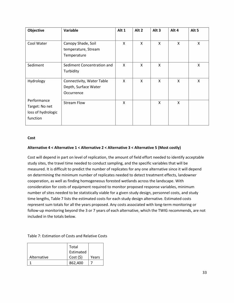
33
Objective Variable Alt 1 Alt 2 Alt 3 Alt 4 Alt 5
Cool Water Canopy Shade, Soil
temperature, Stream
Temperature
X X X X X
Sediment Sediment Concentration and
Turbidity
X X X X
Hydrology
Performance
Target: No net
loss of hydrologic
function
Connectivity, Water Table
Depth, Surface Water
Occurrence
X X X X X
Stream Flow X X X
Cost
Alternative 4 < Alternative 1 < Alternative 2 < Alternative 3 < Alternative 5 (Most costly)
Cost will depend in part on level of replication, the amount of field effort needed to identify acceptable
study sites, the travel time needed to conduct sampling, and the specific variables that will be
measured. It is difficult to predict the number of replicates for any one alternative since it will depend
on determining the minimum number of replicates needed to detect treatment effects, landowner
cooperation, as well as finding homogeneous forested wetlands across the landscape. With
consideration for costs of equipment required to monitor proposed response variables, minimum
number of sites needed to be statistically viable for a given study design, personnel costs, and study
time lengths, Table 7 lists the estimated costs for each study design alternative. Estimated costs
represent sum totals for all the years proposed. Any costs associated with long-term monitoring or
follow-up monitoring beyond the 3 or 7 years of each alternative, which the TWIG recommends, are not
included in the totals below.
Table 7: Estimation of Costs and Relative Costs
Alternative
Total Estimated Cost ($) Years
1 862,400 7

34
2 867,350 7
3 878,900 7
4 380,600 3
5 1,296,800 7
Budget
The following project budget is from the CMER Master Schedule reviewed and approved in spring 2016.
The budget includes funds for the Forested Wetlands Effectiveness Project, as well as for the sub-
questions of temperature and connectivity.
Budget
2016 2017 2018 2019 2020 2021 2022
25000 150000 350000 460000 460000 460000 460000
35
References
Abdelnour, A., McKane, R., Stieglitz, M. , Pan, F., Cheng, Y., 2013. Effects of harvest on carbon and
nitrogen dynamics in a Pacific Northwest forest catchment.,Water Resour. Res., 49, 1292–1313,
doi:10.1029/2012WR012994.
Adams, P.W., Flint, A.L., Fredriksen, R.L., 1991. Long-term patterns in soil moisture and revegetation after a clearcut of a Douglas-fir forest in Oregon. Forest Ecology and Management 41, 249-263.
Adamus, P., 2014. Effects of Forest Roads and Tree Removal In or Near Wetlands of the Pacific Northwest: A Literature Synthesis. Cooperative Monitoring, Evaluation, and Research Committee Washington Department of Natural Resources.
Aust, W.M., Reisinger, T.W., Burger, J.A., Stokes, B.J., 1993. Soil Physical and Hydrological Changes Associated with Logging a Wet Pine Flat with Wide-Tired Skidders. Southern Journal of Applied Forestry 17, 22-25.
Baron, J.S., Driscoll, C.T., Stoddard, J.L., Richer, E.E., 2011. Empirical critical loads of atmospheric
nitrogen deposition for nutrient enrichment and acidification of sensitive US lakes. Bioscience, 61 (8),
602-613.
Batzer, D.P., Sharitz, R.R. 2014. Ecology of Freshwater and Estuarine Wetlands, 2 ed. University of California Press.
Berris, S.N. and R.D. Harr, 1987. Comparative snow accumulation and melt during rainfall in forested and clear-cut plots in the Western Cascades of Oregon. Water Resources Research 23:135-142.
Beschta, R.L., 1978. Long-term patterns of sediment production following road construction and logging in the Oregon Coast Range. Water Resources Research 14, 1011-1016.
Bonin, H.L., Griffiths, R.P., Caldwell, B.A., 2003. Nutrient and microbiological characteristics of fine benthic organic matter in sediment settling ponds. Freshwater Biology 48, 1117-1126.
Bosch, J.M., Hewlett, J.D., 1982. A review of catchment experiments to determine the effect of vegetation changes on water yield and evapotranspiration. Journal of Hydrology 55, 3-23.
Bradley, C., 2001. Wetlands (third edition) by W.J. Mitsch and J.G. Gosselink. John Wiley & Sons, New York, 2000. 920 pp.
Bridgham, S.D., Richardson, C.J., Maltby, E., Faulkner, S.P., 1991. Cellulose Decay in Natural and Disturbed Peatlands in North Carolina. Journal of Environmental Quality 20, 695.

36
Chamberlin, T.W., Harr, R.D., Everest, F.H., 1991. Timber harvesting, silviculture, and watershed processes, in: Meehan, W.R. (Ed.), Influences of forest and rangeland management on salmonid fishes and their habitats. American Fisheries Society, Bethesda, MD.
Cheng, J.D., 1988. Subsurface stormflows in the highly permeable forested watersheds of southwestern British Columbia. Journal of Contaminant Hydrology 3, 171-191.
Cheng, J.D., Black, T.A., deVries, J., Willington, R.P., Goodell, B.C., 1975. The evaluation of initial changes in peak streamflow following logging of a watershed on the west coast of Canada, Proceedings of the Tokyo Symposium. IAHS.
Coffin, B.A., Harr, R.D., 1992. Effects of forest cover on volume of water delivery to soil during rain-on-snow. Final report for Project SH-1, Sediment, Hydrology, and Mass Wasting Steering Committee, Timber, Fish, and Wildlife Program Washington. Seattle, WA: College of Forest Resources, AR-10, University of Washington.
Cole, C.A., 2002. The assessment of herbaceous plant cover in wetlands as an indicator of function. 2, 287-293.
Cubbage, F.W., Flather, C.H., 1993. Forested wetland area and distribution: a look at the south. J. For. 91.
Cullen, S.J., Montagne, C., Ferguson, H., 1991. Timber harvest trafficking and soil compaction in western Montana. Soil Science Society of America Journal 55, 1416-1421.
De Vries, J., Chow, T.L., 1978. Hydrologic behavior of a forested mountain soil in coastal British Columbia. Water Resources Research 14, 935-942.
Dubé, S., Plamondon, A.P., Rothwell, R.L., 1995. Watering up After Clear-Cutting on Forested Wetlands of the St. Lawrence Lowland. Water Resources Research 31, 1741-1750.
Eaton, B.C., Moore, R.D., Giles, T.R., 2010. Forest fire, bank strength and channel instability: the ‘unusual’ response of Fishtrap Creek, British Columbia. Earth Surface Processes and Landforms 35, 1167-1183.
Engineers, U.S.A.C.o., 1987. Corps of Engineers Wetlands Delineation Manual., in: Environmental Laboratory U.S. Army Corps of Engineers, W.E.S., Wetlands Research Program Technical Report (Ed.), Vicksburg, MS.
Ensign, S.H., Mallin, M.A., 2001. Stream water quality changes following timber harvest in a coastal plain swamp forest. Water Research 35, 3381-3390.
Froehlich, H.A., Miles, D.W.R., Robbins, R.W., 1985. Soil bulk density recovery on compacted skid trails in central Idaho. Soil Science Society of America Journal 49, 1015-1017.

37
Golden, H. E., Lane, C. R., Amatya, D. M., Bandilla, K. W., Kiperwas, H. R., Knightes, C. D., & Ssegane, H. 2014. Hydrologic connectivity between geographically isolated wetlands and surface water systems: a review of select modeling methods. Environmental Modelling & Software, 53, 190-206.
Golding, D. L. and Swanson, R. H., 1986. Snow distribution patterns in clearings and adjacent forest, Water Resources Research 22, 1931–1940, doi:10.1029/WR022i013p01931.
Gomi, T., Moore, R.D., Dhakal, A.S., 2006. Headwater stream temperature response to clear-cut harvesting with different riparian treatments, coastal British Columbia, Canada. Water Resources Research 42, n/a-n/a.
Guenther, S.M., Gomi, T., Moore, R.D., 2014. Stream and bed temperature variability in a coastal headwater catchment: influences of surface-subsurface interactions and partial-retention forest harvesting. Hydrological Processes 28, 1238-1249.
Guenther, S.M., Moore, R.D., Gomi, T., 2012. Riparian microclimate and evaporation from a coastal headwater stream, and their response to partial-retention forest harvesting. Agricultural and Forest Meteorology 164, 1-9.
Hanson, M.A., Bowe, S.E., Ossman, F.G., Fieberg, J., Butler, M.G., Koch, R., 2009. Influences of forest harvest and environmental gradients on aquatic invertebrate communities of seasonal ponds. Wetlands 29, 884-895.
Hanson, M.A., Palik, B.J., Church, J.O., Miller, A.T., 2010. Influences of upland timber harvest on aquatic invertebrate communities in seasonal ponds: efficacy of forested buffers. Wetlands Ecology and Management 18, 255-267.
Harms, T.K., Edmonds, J.W., Genet, H., Creed, I.F., Aldred, D., Balser, A., Jones, J.B., 2016. Catchment influence on nitrate and dissolved organic matter in Alaskan streams across a latitudinal gradient. Journal of Geophysical Research: Biogeosciences 121, 350-369.
Harr, R.D., Harper, W.C., Krygier, J.T., Hsieh, F.S., 1975. Changes in storm hydrographs after road building and clear-cutting in the Oregon Coast Range. Water Resources Research 11, 436-444.
Harr, R.D., 1982. Fog drip in the Bull Run Municipal Watershed, Oregon. Water Resources Bulletin 18, 785-789.
Harr, R.D., 1983. Potential for augmenting water yield through forest practices in western Washington and western Oregon. Water Resources Bulletin 19:383-392.
Harr, R.D., Coffin, B.A. 1992. Influence of timber harvest on rain-on-snow runoff: a mechanism for cumulative watershed effects. In: Jones, Mikeal E.; Laenen, Antonius, eds. Interdisciplinary approaches in hydrology and hydrogeology. [Place of publication unknown]: American Institute of Hydrology: 455-469.
38
Harr, R.D., A. Levno, and R. Mersereau, 1982. Streamflow changes after logging 130-year-old Douglas Fir in two small watersheds. Water Resources Research 18: 637-644.
Harr, R.D., Coffin, B.A., 1992. Influence of timber harvest on rain-on-snow runoff: a mechanism for cumulative effects. Presented at the Annual Meeting of the American Institute of Hydrology. Portland, Oregon. October 1992.
Harris, D.D., 1977. Hydrologic Changes After Logging in Two Small Oregon Coastal Watersheds. Water-Supply Paper 2037, U.S. Geological Survey, Washington, D.C., 31 pp.
Hetherington, E.D., 1982. Effects of forest harvesting on the hydrologic regime of Carnation Creek Experimental Watershed: a preliminary assessment. Canadian Hydrology Symposium. National Research Council of Canada, Ottawa, pp. 247-267.
Hibbert, A.R., 1967. Forest treatment effects on water yield, in: Sopper, W.E., Lull, H.W. (Eds.), International Symposium on Forest Hydrology. Pergamon, Oxford.
Hicks, B.J., Beschta, R.L., Harr, R.D., 1991. Long-term changes in streamflow following logging in Western Oregon and associated fisheries implications. Water Resources Bulletin 27, 217-226.
Hill, A.R., Devito, K.J., 1997. Hydrological-Chemical Interactions in Headwater Forest Wetlands, in: Trettin, C.C., Jurgensen, M.F., Grigal, D.F., Gale, M.R., Jeglum, J.K. (Eds.), Northern Forested Wetlands: Ecology and Management. CRC Press, Inc., Boca Raton, pp. 213-230.
Hudson, R., 2000. Snowpack recovery in regenerating coastal British Columbia clearcuts. Canadian Journal of Forest Research 30, 548-556.
Janisch, J.E., Foster, A.D., Ehinger, W.J., 2011a. Characteristics of small headwater wetlands in second-growth forests of Washington, USA. Forest Ecology and Management 261, 1265-1274.
Janisch, J.E., Foster, A.D., Ehinger, W.J., 2011b. Characteristics of small headwater wetlands in second-growth forests of Washington, USA. Forest Ecology and Management 261, 1265-1274.
Janisch, J.E., Wondzell, S.M., Ehinger, W.J. 2012. Headwater stream temperature: interpreting response after logging, with and without riparian buffers, Washington, USA. Forest Ecology and Management 270, 302–313.
Johnson, E.A., Miyanishi, K., 2008. Testing the assumptions of chronosequences in succession. Ecology Letters 11, 419-431.
Jones, J.A., 2000. Hydrologic processes and peak discharge response to forest removal, regrowth, and roads in 10 small experimental basins, western Cascades, Oregon. Water Resources Research 36, 2621-2642.
Jones, J.A., Post, D.A., 2004. Seasonal and successional streamflow response to forest cutting and regrowth in the northwest and eastern United States. Water Resources Research 40.

39
Keppeler, E.T., Ziemer, R.R., 1990. Logging effects on streamflow: Water yield and summer low flows at Caspar Creek in northwestern California. Water Resources Research 26, 1669-1679.
Kolka, R.K., Palik, B.J., Tersteeg, D.P., Bell, J.C., 2011. Effects of riparian buffers on hydrology of northern seasonal ponds. Transactions of the ASABE 54, 2111-2116.
Lewis, D., Huggard, D., 2010. A model to quantify effects of mountain pine beetle on equivalent clearcut area. Streamline Watershed Management Bulletin 13, 42-51.
Lockaby, B.G., Clawson, R.G., Flynn, K., Rummer, R., Meadows, S., Stokes, B., Stanturf, J., 1997a. Influence of harvesting on biogeochemical exchange in sheetflow and soil processes in a eutrophic floodplain forest. Forest Ecology and Management 90, 187-194.
Lockaby, B.G., Jones, R.H., Clawson, R.G., Meadows, J.S., Stanturf, J.A., Thornton, F.C., 1997b. Influences of harvesting on functions of floodplain forests associated with low-order, blackwater streams. Forest Ecology and Management 90, 217-224.
Lockaby, B.G., Stanturf, J.A., Messina, M.G., 1997c. Effects of silvicultural activity on ecological processes in floodplain forests of the southern United States: a review of existing reports. Forest Ecology and Management 90, 93-100.
Lockaby, B.G., Thornton, F.C., Jones, R.H., Clawson, R.G., 1994. Ecological responses of an oligotrophic floodplain forest to harvesting. Journal of Environmental Quality 23, 901-906.
Lugo, A.E., Brown, S., Brinson, M.M., 1988. Forested wetlands in freshwater and salt-water environments. Limnology and Oceanography 33, 894-909.
Maltby, E., Immirzi, P., 1993. Carbon dynamics in peatlands and other wetland soils regional and global perspectives. Chemosphere 27, 999-1023.
Marcotte, P., Roy, V., Plamondon, A.P., Auger, I., 2008. Ten-year water table recovery after clearcutting and draining boreal forested wetlands of eastern Canada. Hydrological Processes 22, 4163-4172.
Marks, D., Winstral, A., Reba, M., Pomeroy, J., Kumar, M., 2013. An evaluation of methods for determining during-storm precipitation phase and the rain/snow transition elevation at the surface in a mountain basin. Advances in Water Resources 55, 98-110.
May, C.L., Gresswell, R.E., 2003. Processes and rates of sediment and wood accumulation in headwater streams of the Oregon Coast Range, USA. Earth Surface Processes and Landforms 28, 409-424.
McGuire, K.J., McDonnell, J.J., 2010. Hydrological connectivity of hillslopes and streams: Characteristic time scales and nonlinearities. Water Resources Research 46, n/a-n/a.
McLaughlin, J.W., Calhoon, E.B.W., Gale, M.R., Jurgensen, M.F., Trettin, C.C., 2011. Biogeochemical cycling and chemical fluxes in a managed northern forested wetland, Michigan, USA. Forest Ecology and Management 261, 649-661.

40
McNabb, D.H., Gaweda, F., Froehlich, H.A., 1989. Infiltration, Water Repellency, and Soil Moisture Content After Broadcast Burning a Forest Site in Southwest Oregon. Journal of Soil and Water Conservation 44, 87-90.
Moore, G.W., Bond, B.J., Jones, J.A., Phillips, N., Meinzer, F.C., 2004. Structural and compositional controls on transpiration in 40-and 450-year-old riparian forests in western Oregon, USA. Tree physiology 24, 481-491.
Moore, R.D., Wondzell, S.M., 2005. Physical hydrology and the effects of forest harvesting in the Pacific Northwest: A review.. JAWRA Journal of the American Water Resources Association 41, 763-784.
Palik, B., Batzer, D.P., Buech, R., Nichols, D., Cease, K., Egeland, L., Streblow, D.E., 2001. Seasonal pond characteristics across a chronosequence of adjacent forest ages in northern Minnesota, USA. Wetlands 21, 532-542.
Palik, B.J., Kastendick, D., 2010. Response of seasonal pond plant communities to upland forest harvest in northern Minnesota forests, USA. Forest ecology and management 260, 628-637.
Pardo, L. H., Robin-Abbott, M.J., Driscoll. C. 2011. Assessment of nitrogen deposition effects and
empirical critical loads of nitrogen for ecoregions of the United States. Gen. Tech. Rep. NRS 80: 291
Perry, G., Lundquist, J., Moore, R.D., 2016. Review of the potential effects of forest practices on stream flow in the Chehalis River Basin. Report submitted to the Chehalis Flood Damage Reduction Technical Committee.
Phillips, P.J., Denver, J.M., Shedlock, R.J., Hamilton, P.A., Effect of forested wetlands on nitrate concentrations in ground water and surface water on the Delmarva Peninsula. Wetlands 13, 75-83.
Post, D.A., Jones, J.A., 2001. Hydrologic regimes of forested, mountainous, headwater basins in New Hampshire, North Carolina, Oregon, and Puerto Rico. Advances in Water Resources 24, 1195-1210.
Rayne, S., Henderson, G., Gill, P., Forest, K., 2008. Riparian Forest Harvesting Effects on Maximum Water Temperatures in Wetland-sourced Headwater Streams from the Nicola River Watershed, British Columbia, Canada. Water Resources Management 22, 565-578.
Reneau, S.L., Dietrich, W.E., 1991. Erosion rates in the southern Oregon Coast Range: Evidence for an equilibrium between hillslope erosion and sediment yield. Earth Surface Processes and Landforms 16, 307-322.
Rex, J., Dubé, S., 2006. Predicting the risk of wet ground areas in the Vanderhoof Forest District: Project description and progress report. Journal of Ecosystems and Management; Vol 7, No 2 (2006).
Roy, V., 1996. Water table fluctuations following clearcutting and thinning on Wally Creek wetlands. Northern forested wetlands: ecology and management. Edited by C.C. Trettin, P.239-251.
41
Roy, V., Ruel, J.-C., Plamondon, A.P., 2000. Establishment, growth and survival of natural regeneration after clearcutting and drainage on forested wetlands. Forest Ecology and Management 129, 253-267.
Rubec, C.D.A., 1997. Policy for conservation of the functions and values of forested wetlands. Northern forested wetlands: ecology and management. Edited by C.C. Trettin, P.45-59.
Shepard, J.P., Effects of forest management on surface water quality in wetland forests. Wetlands 14, 18-26.
Slesak, R.A., Lenhart, C.F., Brooks, K.N., D’Amato, A.W., Palik, B.J., 2014. Water table response to harvesting and simulated emerald ash borer mortality in black ash wetlands in Minnesota, USA. Canadian Journal of Forest Research 44, 961-968.
Spittlehouse, D.L., 1998. Rainfall interception in young and mature conifer forests in British Columbia. In: Proc. 23rd Conference on Agricultural and Forest Meteorology (Albuquerque, New Mexico). American Meteorological Society, Boston, Massachusetts, pp. 171-174.
Startsev, A.D. and D.H. McNabb, 2000. Effects of skidding on forest soil infiltration in west-central
Alberta. Canadian Journal of Soil Science 80:617-624.
Startsev, A.D., McNabb, D.H., 2001. Skidder Traffic Effects on Water Retention, Pore-Size Distribution, and van Genuchten Parameters of Boreal Forest Soils. Soil Science Society of America Journal 65, 224.
Stednick, J.D., 1996. Monitoring the effects of timber harvest on annual water yield. Journal of Hydrology 176, 79-95.
Stednick, J.D., Kern, T.J., 1992. Long term effects of timber harvesting in the Oregon Coast Range: The New Alsea Watershed Study (NAWS), Interdisciplinary Approaches to Hydrology and Hydrogeology. American Institute of Hydrology, Smyrna, GA, pp. 502-510.
Storck, P., D.P. Lettenmaier, and S.M. Bolton, 2002. Measurement of Snow Interception and Canopy Effects on Snow Accumulation and Melt in a Mountainous Maritime Climate, Oregon, United States. Water Resources Research 38: 1223, doi:10.1029/2002WR001281, 2002.
Sun, G., McNulty, S.G., Shepard, J.P., Amatya, D.M., Riekerk, H., Comerford, N.B., Skaggs, W., Swift Jr, L., 2001. Effects of timber management on the hydrology of wetland forests in the southern United States. Forest Ecology and Management 143, 227-236.
Tague, C., Band, L., 2001. Simulating the impact of road construction and forest harvesting on hydrologic response. Earth Surface Processes and Landforms 26, 135-151.
Trettin, C.C., Davidian, M., Jurgensen, M.F., Lea, R., 1996. Organic Matter Decomposition following Harvesting and Site Preparation of a Forested Wetland. Soil Science Society of America Journal 60.
42
Trettin, C.C., Jurgensen, M.F., Gale, M.R., McLaughlin, J.W., 2011. Recovery of carbon and nutrient pools in a northern forested wetland 11 years after harvesting and site preparation. Forest Ecology and Management 262, 1826-1833.
Trettin, C.C., Jurgensen, M.F., McLaughlin, J.W., Gale, M.R., 1997. Effects of forest management on wetland functions in a sub-boreal swamp. In, in: Trettin, C.C., Jurgensen, M.F., Grigal, D.F., Gale, M.R., Jeglum, J. (Eds.), Northern Forested Wetlands: Ecology and Management. CRC/Lewis Publishers, Boca Raton, FL, pp. 411-428.
Verry, E.S., 1997. Hydrological processes of natural, northern forested wetlands. Northern forested wetlands: Ecology and management, 163-188.
Walbridge, M.R., Lockaby, B.G., Effects of forest management on biogeochemical functions in southern forested wetlands. Wetlands 14, 10-17.
Wemple, B.C., Jones, J.A., Grant, G.E., 1996. Channel network extension by logging roads in two basins, Western Cascades, Oregon. JAWRA Journal of the American Water Resources Association 32, 1195-1207.
Wheeler, K. 1987. Interception and redistribution of snow in a subalpine forest on a storm-by-storm basis. Proceedings of the 55th Annual Western Snow Conference (Vancouver, B.C.), Colorado State University, Fort Collins, Colorado, pp. 78-87.
Winkler, R.D., Moore, R.D., Redding, T.E., Spittlehouse, B.D.S., Carlyle-Moses, D.E., 2010. The effects of forest disturbance on hydrologic processes and watershed response., in: Pike, R.G., Redding, T.E., Moore, R.D., Winkler, R.D., Bladon, K.D. (Eds.), Compendium of Forest Hydrology and Geomorphology in British Columbia. B.C. Min. For. Range, For. Sci. Prog., Victoria, B.C.
Winkler, R.D., Spittlehouse, D.L., Golding, D.L., 2005. Measured differences in snow accumulation and melt among clearcut, juvenile, and mature forests in southern British Columbia. Hydrological Processes 19, 51-62.
Zarnetske, J.P., Haggerty, R., Wondzell, S.M., Baker, M.A., 2011. Dynamics of nitrate production and removal as a function of residence time in the hyporheic zone. Journal of Geophysical Research 116.
Ziemer, R.R., 1981. Storm flow response to road building and partial cutting in small streams of northern California. Water Resources Research 17, 907-917.

43
Appendix A
Forest Practices Rules Addressed
The following section summarizes, or details, the forest practices rules pertaining to forested wetlands
and timber harvest. With respect to wetlands, a major goal is no-net-loss of spatial extent and function.
In 1989, the Washington state governor adopted a statewide policy of no net loss of area and function
of wetlands, and this included forest practices.
Rules
WAC 220-30-010: Wetland areas serve several significant functions in addition to timber production:
Providing fish and wildlife habitat, protecting water quality, moderating and preserving water quantity.
Wetlands may also contain unique or rare ecological systems. The wetland management zone and
wetland requirements specified in this chapter are designed to protect these wetland functions when
measured over the length of a harvest rotation, although some functions may be reduced until the
midpoint of the timber rotation cycle. Landowners are encouraged to voluntarily increase wetland
acreage and functions over the long-term.
WAC 220-30-020 (6): Forested wetlands. Within the wetland, unless otherwise approved in writing by
the department, harvest methods shall be limited to low impact harvest or cable systems. Where
feasible, at least one end of the log shall be suspended during yarding.
Landowners are encouraged to retain leave-trees in forested wetlands
If the RMZ or WMZ lies within a forested wetland, leave tree requirements for those areas may
be counted toward percentages of this subsection
Approximate determination of the boundaries and mapping of forested wetlands greater than 3
acres shall be required.
The department shall consult with the department of fish and wildlife and affected Indian tribes
about site specific impacts of forest practices on wetland-sensitive species in forested wetlands.
WAC 222-24-035: Minimize placement and size of landings within forested wetlands
WAC 222-30-070: Where harvest in wetlands is permitted, ground-based logging systems shall be
limited to low impact harvest systems. Ground-based logging systems operating in wetlands shall only
be allowed during period of low soil moisture or frozen soil conditions.
WAC 222-12-045 (Forest Practices Rules): Adaptive Management Program, Program Elements, Key
questions and resource objectives: Resource objectives are intended to ensure that forest practices,

44
either singularly or cumulatively, will not significantly impair the capacity of aquatic habitat to: a)
support harvestable levels of salmonids b) support the long-term viability of other covered species; or c)
meet or exceed water quality standards (protection of beneficial uses, narrative and numeric criteria,
and antidegradation).

45
Appendix B
Forest and Fish Report Performance Targets
The performance targets are also listed in WAC 222-12-045 (Forest Practices Rules).
Resource Objectives (Schedule L-1):
-Maintain surface and groundwater hydrologic regimes (magnitude, frequency, timing, and
routing of stream flows) by disconnecting road drainage from the stream network, preventing
increases in peak flows causing scour, and maintaining the hydrologic continuity of wetlands.
Target: No net loss in the hydrologic functions of wetlands
-Provide cool water by maintaining shade, groundwater temperature, flow, and other
watershed processes controlling stream temperature.
- Prevent the delivery of excessive sediment to streams by protecting stream bank integrity,
providing vegetative filtering, protecting unstable slopes, and preventing the routing of
sediment to streams
-Provide complex in- and near-stream habitat by recruiting large woody debris and litter fall to
streams.
-Use forest chemicals in a manner that meets or exceeds water quality standards and label
requirements by buffering surface water and otherwise using best management practices.
46
Appendix C
October 2015
Leah Beckett, CMER Wetland Scientist
FPARS Survey for Forested Wetlands
Introduction
A survey of forest practices applications (FPA) was undertaken in order to gather information that may
inform a study on the effectiveness of forest practices rules at maintaining or restoring wetland function
in harvested forested wetlands.
Survey Objectives:
1. To characterize the population of forested wetlands that were reported on forest practices
applications (FPA) between July 10, 2010 and July 10, 2015. In order to:
2. Identify regional patterns in the occurrence and harvest of forested wetlands during that time
period, to identify the average size of forested wetlands that were harvested, and to determine
whether the majority of forested wetlands occurred adjacent to streams
Methods
A survey of forest practices applications (FPAs) was conducted between July-October 2015 utilizing the
Forest Practices Application Review System (FPARS). FPARS is a searchable database of PDFs of all
applications submitted by landowners planning to conduct forest practices on their land. Applications in
the FPARS database with harvest units containing forested wetlands can be identified by sorting by the
data field “Activity occurring in or near a forested wetland”.
A date range was selected: July 10, 2010-July 10, 2015, and all FPAs submitted during that time were
counted by DNR region. To determine what region has more forest practices activities affecting forested
wetlands, the count was repeated for all FPAs submitted during the same time that had forested
wetlands flagged.
For each DNR region, 30 FPAs containing forested wetlands were randomly selected using a random
number generator (random numbers corresponded to a position on the list of FPAs containing forested
wetlands in each region), and information was collected from each of the 30 randomly selected FPAs.
Caveats:
The FPARs database includes information on the subset of forested wetlands occurring in timber harvest
units on state or private lands under jurisdiction of the state forest practices rules. The population of
forested wetlands identified on FPARS is a subset of the overall population of forested wetlands in WA
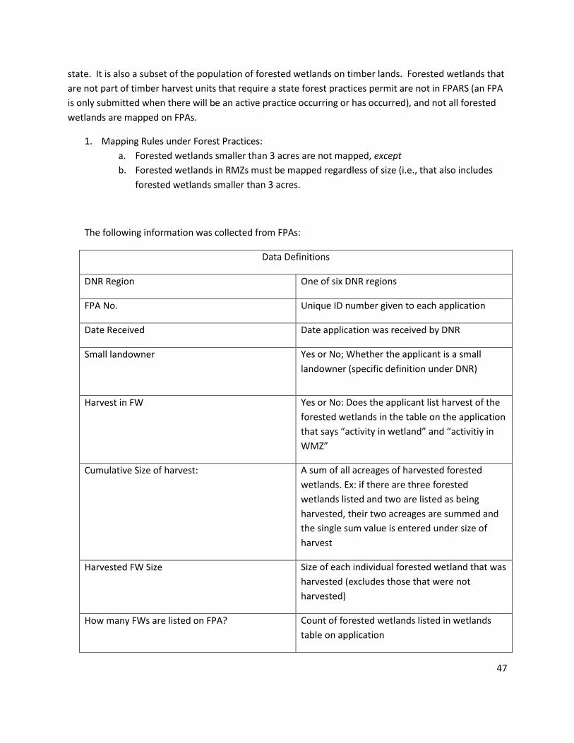
47
state. It is also a subset of the population of forested wetlands on timber lands. Forested wetlands that
are not part of timber harvest units that require a state forest practices permit are not in FPARS (an FPA
is only submitted when there will be an active practice occurring or has occurred), and not all forested
wetlands are mapped on FPAs.
1. Mapping Rules under Forest Practices:
a. Forested wetlands smaller than 3 acres are not mapped, except
b. Forested wetlands in RMZs must be mapped regardless of size (i.e., that also includes
forested wetlands smaller than 3 acres.
The following information was collected from FPAs:
Data Definitions
DNR Region One of six DNR regions
FPA No. Unique ID number given to each application
Date Received Date application was received by DNR
Small landowner
Yes or No; Whether the applicant is a small
landowner (specific definition under DNR)
Harvest in FW Yes or No: Does the applicant list harvest of the
forested wetlands in the table on the application
that says “activity in wetland” and “activitiy in
WMZ”
Cumulative Size of harvest: A sum of all acreages of harvested forested
wetlands. Ex: if there are three forested
wetlands listed and two are listed as being
harvested, their two acreages are summed and
the single sum value is entered under size of
harvest
Harvested FW Size Size of each individual forested wetland that was
harvested (excludes those that were not
harvested)
How many FWs are listed on FPA? Count of forested wetlands listed in wetlands
table on application
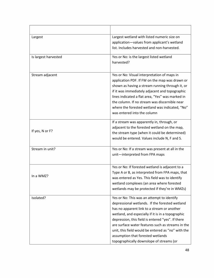
48
Largest
Largest wetland with listed numeric size on
application—values from applicant’s wetland
list. Includes harvested and non-harvested.
Is largest harvested
Yes or No: is the largest listed wetland
harvested?
Stream adjacent
Yes or No: Visual interpretation of maps in
application PDF. If FW on the map was drawn or
shown as having a stream running through it, or
if it was immediately adjacent and topographic
lines indicated a flat area, “Yes” was marked in
the column. If no stream was discernible near
where the forested wetland was indicated, “No”
was entered into the column
If yes, N or F?
If a stream was apparently in, through, or
adjacent to the forested wetland on the map,
the stream type (when it could be determined)
would be entered. Values include N, F and S.
Stream in unit?
Yes or No: If a stream was present at all in the
unit—interpreted from FPA maps
In a WMZ?
Yes or No: If forested wetland is adjacent to a
Type A or B, as interpreted from FPA maps, that
was entered as Yes. This field was to identify
wetland complexes (an area where forested
wetlands may be protected if they’re in WMZs)
Isolated?
Yes or No: This was an attempt to identify
depressional wetlands. If the forested wetland
has no apparent link to a stream or another
wetland, and especially if it is in a topographic
depression, this field is entered “yes”. If there
are surface water features such as streams in the
unit, this field would be entered as “no” with the
assumption that forested wetlands
topographically downslope of streams (or
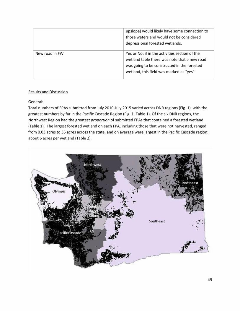
49
upslope) would likely have some connection to
those waters and would not be considered
depressional forested wetlands.
New road in FW Yes or No: if in the activities section of the
wetland table there was note that a new road
was going to be constructed in the forested
wetland, this field was marked as “yes”
Results and Discussion
General:
Total numbers of FPAs submitted from July 2010-July 2015 varied across DNR regions (Fig. 1), with the
greatest numbers by far in the Pacific Cascade Region (Fig. 1, Table 1). Of the six DNR regions, the
Northwest Region had the greatest proportion of submitted FPAs that contained a forested wetland
(Table 1). The largest forested wetland on each FPA, including those that were not harvested, ranged
from 0.03 acres to 35 acres across the state, and on average were largest in the Pacific Cascade region:
about 6 acres per wetland (Table 2).

50
Figure 1: DNR Regions and density of all active FPAs in the state. FPA unit boundaries are in black (Arc
GIS, WA DNR data)
Table 1: Total number of FPAs submitted during July 2010-July 2015 by DNR region. Proportion of those
FPAs that contain forested wetlands
Region Total FPAs FPAs with FW flagged %
Northeast 4247 294 7
Northwest 3473 691 20
Olympic 3236 387 12
Pacific Cascade 8846 735 8
South Puget Sound 4354 534 12
Southeast 1270 80 6
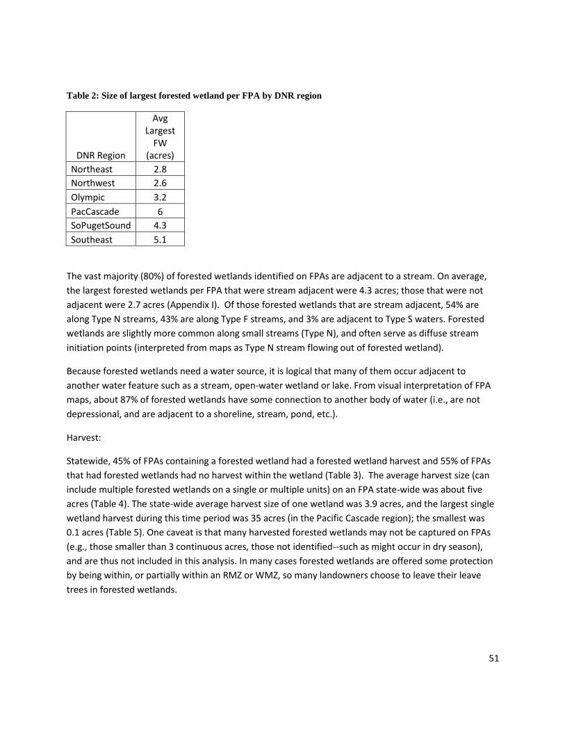
51
Table 2: Size of largest forested wetland per FPA by DNR region
DNR Region
Avg Largest
FW (acres)
Northeast 2.8
Northwest 2.6
Olympic 3.2
PacCascade 6
SoPugetSound 4.3
Southeast 5.1
The vast majority (80%) of forested wetlands identified on FPAs are adjacent to a stream. On average,
the largest forested wetlands per FPA that were stream adjacent were 4.3 acres; those that were not
adjacent were 2.7 acres (Appendix I). Of those forested wetlands that are stream adjacent, 54% are
along Type N streams, 43% are along Type F streams, and 3% are adjacent to Type S waters. Forested
wetlands are slightly more common along small streams (Type N), and often serve as diffuse stream
initiation points (interpreted from maps as Type N stream flowing out of forested wetland).
Because forested wetlands need a water source, it is logical that many of them occur adjacent to
another water feature such as a stream, open-water wetland or lake. From visual interpretation of FPA
maps, about 87% of forested wetlands have some connection to another body of water (i.e., are not
depressional, and are adjacent to a shoreline, stream, pond, etc.).
Harvest:
Statewide, 45% of FPAs containing a forested wetland had a forested wetland harvest and 55% of FPAs
that had forested wetlands had no harvest within the wetland (Table 3). The average harvest size (can
include multiple forested wetlands on a single or multiple units) on an FPA state-wide was about five
acres (Table 4). The state-wide average harvest size of one wetland was 3.9 acres, and the largest single
wetland harvest during this time period was 35 acres (in the Pacific Cascade region); the smallest was
0.1 acres (Table 5). One caveat is that many harvested forested wetlands may not be captured on FPAs
(e.g., those smaller than 3 continuous acres, those not identified--such as might occur in dry season),
and are thus not included in this analysis. In many cases forested wetlands are offered some protection
by being within, or partially within an RMZ or WMZ, so many landowners choose to leave their leave
trees in forested wetlands.
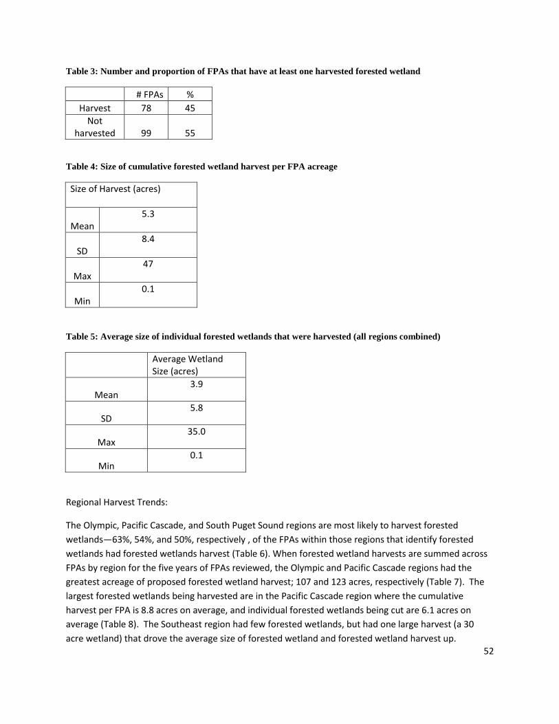
52
Table 3: Number and proportion of FPAs that have at least one harvested forested wetland
# FPAs %
Harvest 78 45
Not harvested 99 55
Table 4: Size of cumulative forested wetland harvest per FPA acreage
Size of Harvest (acres)
Mean 5.3
SD 8.4
Max 47
Min 0.1
Table 5: Average size of individual forested wetlands that were harvested (all regions combined)
Average Wetland Size (acres)
Mean 3.9
SD 5.8
Max 35.0
Min 0.1
Regional Harvest Trends:
The Olympic, Pacific Cascade, and South Puget Sound regions are most likely to harvest forested
wetlands—63%, 54%, and 50%, respectively , of the FPAs within those regions that identify forested
wetlands had forested wetlands harvest (Table 6). When forested wetland harvests are summed across
FPAs by region for the five years of FPAs reviewed, the Olympic and Pacific Cascade regions had the
greatest acreage of proposed forested wetland harvest; 107 and 123 acres, respectively (Table 7). The
largest forested wetlands being harvested are in the Pacific Cascade region where the cumulative
harvest per FPA is 8.8 acres on average, and individual forested wetlands being cut are 6.1 acres on
average (Table 8). The Southeast region had few forested wetlands, but had one large harvest (a 30
acre wetland) that drove the average size of forested wetland and forested wetland harvest up.
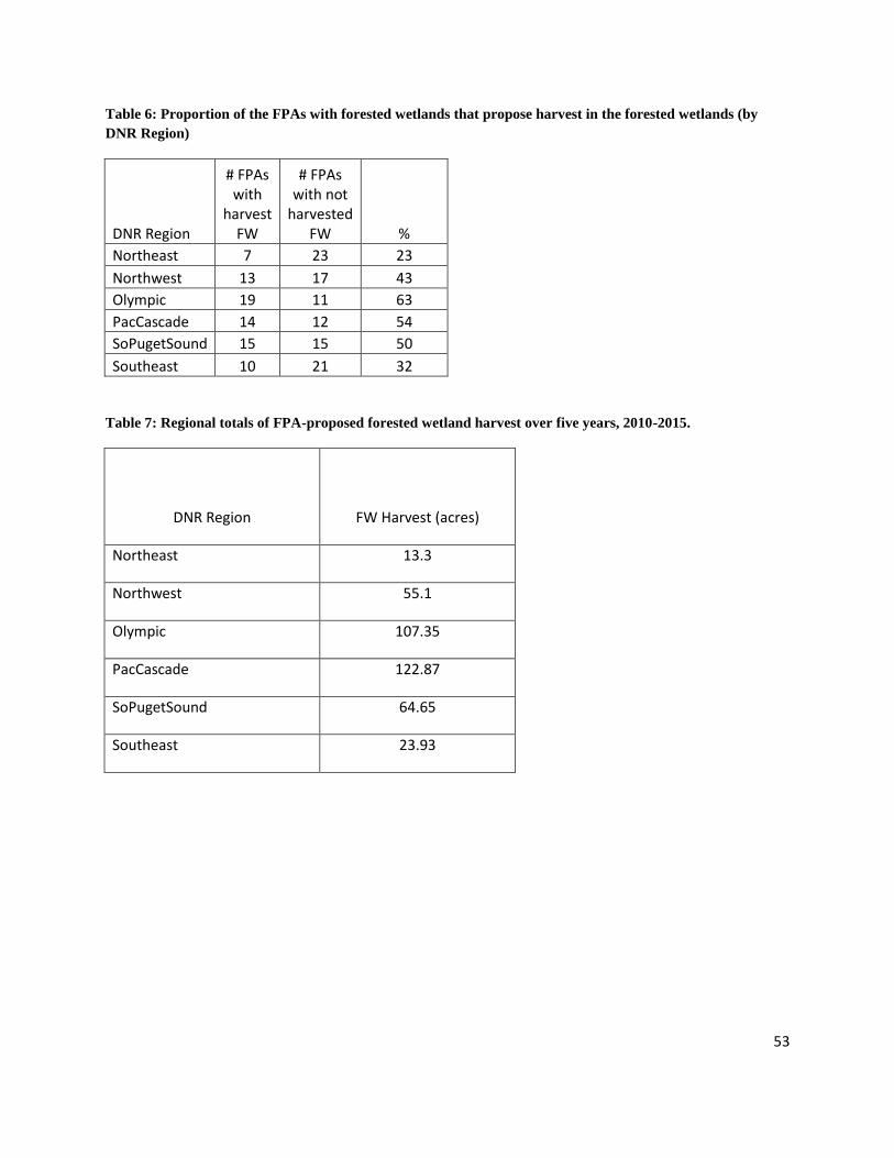
53
Table 6: Proportion of the FPAs with forested wetlands that propose harvest in the forested wetlands (by
DNR Region)
DNR Region
# FPAs with
harvest FW
# FPAs with not
harvested FW %
Northeast 7 23 23
Northwest 13 17 43
Olympic 19 11 63
PacCascade 14 12 54
SoPugetSound 15 15 50
Southeast 10 21 32
Table 7: Regional totals of FPA-proposed forested wetland harvest over five years, 2010-2015.
DNR Region FW Harvest (acres)
Northeast 13.3
Northwest 55.1
Olympic 107.35
PacCascade 122.87
SoPugetSound 64.65
Southeast 23.93

54
Table 8: Average total area of forested wetland harvest per FPA and average size of individual forested
wetlands that were harvested by DNR region
DNR Region
Avg per-FPA
Harvest (acres)
Avg Size of One Forested Wetland Harvest (acres)
Northeast 2.7 2.7
Northwest 3.9 2.4
Olympic 6.0 3.8
PacCascade 8.8 6.1
SoPugetSound 4.3 4.3
Southeast 3.4 3.4
The Pacific Cascade Region had the largest single wetland harvest (a 35 acre forested wetland), and has
on average the largest harvest sizes of forested wetlands and the largest individual forested wetlands;
however, of all the FPAs submitted within the last five years for the Pacific Cascade region, only about
8% had a forested wetland listed. Within the last five years, the total acreage of forested wetland
harvest proposed in FPAs was also greatest for the Pacific Cascade region; however, this may not mean
that there is a higher occurrence of forested wetlands on the landscape, but rather, that the probability
of encountering a forested wetland harvest in this region is higher because a greater proportion of the
land area is in timber production and/or is being harvested. The Pacific Cascade region had the greatest
number of FPAs submitted, indicating more proposed harvests and total harvest area compared to other
regions. Despite this, few FPAs had a forested wetland harvest, so though the total acreage of forested
wetland harvest is higher than other areas, it is small compared to the total harvest acreage.
The Northwest Region had a greater proportion of FPAs submitted with forested wetlands and 43% had
forested wetland harvest; however, the forested wetlands in the Northwest that are harvested are
smaller compared to other regions and total forested wetland harvest area (sum area of all harvested
forested wetlands per FPA) by FPA was smaller comparatively. On average, the size of forested wetlands
that are harvested in the Northwest Region is 2.4 acres, compared to 3.9 acres statewide. One
hypothesis about why the Northwest Region has more forested wetlands affected by forest practices,
and why they harvest more of their forested wetlands is grounded in the soil. During site visits, the
majority of soils in forested wetlands (as mapped on FPAs) were coarse sandy soil with few
redoxomorphic features. NRCS Web Soil Survey maps indicate that a random sample of FPAs with
forested wetland harvests in the Northwest Region contained soils that were predominantly gravelly
loam. These soils are likely well drained which may allow trees to grow faster (since they aren’t under
water stress), and it may also allow a greater range of water-tolerances in tree species—in other words,

55
it is possible that trees that don’t like wet feet may still be able to grow in forested wetlands of the
Northwest Region. By contrast, the forested wetlands visited in the Olympic region had fine silty clay
loam soils that retained water better which may contribute to lower growth rates and limit the variety
of tree species to those that can tolerate perennially saturated growing conditions (i.e., harvested less
often).
Landowner Harvest Trends:
A slightly greater proportion of the forested wetlands are on large landowners’ FPAs (55%) compared to
small landowners (45%), and on average, small forest landowners are more likely to submit FPAs with
forested wetlands harvest compared to large landowners (Table 9). Large landowners may have more
training in identifying forested wetlands and therefore may be more likely to identify them and include
them on FPA maps, a possible explanation for more forested wetlands appearing on lands owned by
large landowners. Another possible explanation is that small landowners whose property is primarily
forested wetland may be less likely to harvest any portion of their property (and so would not submit an
FPA) due to operation costs, compared to large landowners who may have forested wetlands embedded
in larger units that as a whole are more profitable to harvest. Additionally, since small forest
landowners have much smaller harvests, they may be more likely to harvest their forested wetlands to
ensure that their profits exceed operating costs, and to ensure that they cut all marketable trees.
Table 9: Proportion of FPAs with forested wetland harvest by landowner category
Harvested Not
Harvested %
Small Landowner 40 39 51
Large Landowner 38 60
39

56
Implications for the design of the Forested Wetlands Effectiveness Project
The information derived from the FPARS survey is a start for understanding forested wetland
characteristics and harvest patterns. Below are a few considerations, based on the FPARS survey
results, to inform a study design for the Forested Wetlands Effectiveness Project.
Considerations and Suggestions:
Regional Patterns
1. Regions to consider including in the study, or distributing more study sites in, include those that
have the greatest number of forested wetlands (more forested wetlands across a landscape
likely increases the probability of encountering one during forestry operations), those where
harvest is more likely, and those with the largest acreage of forested wetland harvest. These
regions may include Pacific Cascade (largest forested wetlands and largest harvests, high
likelihood of forested wetland harvest), Olympic (many medium-sized forested wetlands, large
total forested wetland harvest, and most likely to harvest forested wetlands), South Puget
Sound (many medium-sized, oft-harvested forested wetlands), and Northwest (large number of
small, harvested forested wetlands).
Landownership Patterns
2. Another consideration is what proportion of the timber land in each region is owned by small
forest landowners compared to larger landowners. It may be difficult to obtain permission to
access sites, so basin-scale studies in regions with many small forest landowners may be
impractical. For this reason, considering regions that have more large landowners who may also
be more willing to participate may be more practical.
Types of Forested Wetlands
3. Another consideration for planning a study is type of forested wetland, in particular, functional
type, which can be inferred by landscape position as well as hydrologic signature (what sources
dominate, and at what time of year, etc.). FPARS is insufficient for gathering such data; however,
a rough approximation can be collected by interpretation of maps to determine whether the
forested wetland has an apparent surface connection with a stream, and if so, roughly what size
that stream is (i.e., Type N or F). Connection is inferred when streams run directly through or
out of forested wetlands as shown on FPARS maps. In other cases, interpreting approximate
distance from a stream or slope position according to topographic lines is useful in
approximating hydrologic sources of forested wetlands.
With that in mind, the majority of forested wetlands on FPARS maps were stream adjacent. As
previously mentioned, this may be because small, isolated forested wetlands are not always
shown on FPAs due to the minimum area criteria for showing forested wetlands on FPAs.
However, any large forested wetlands (>3 acres) that were not stream adjacent would have
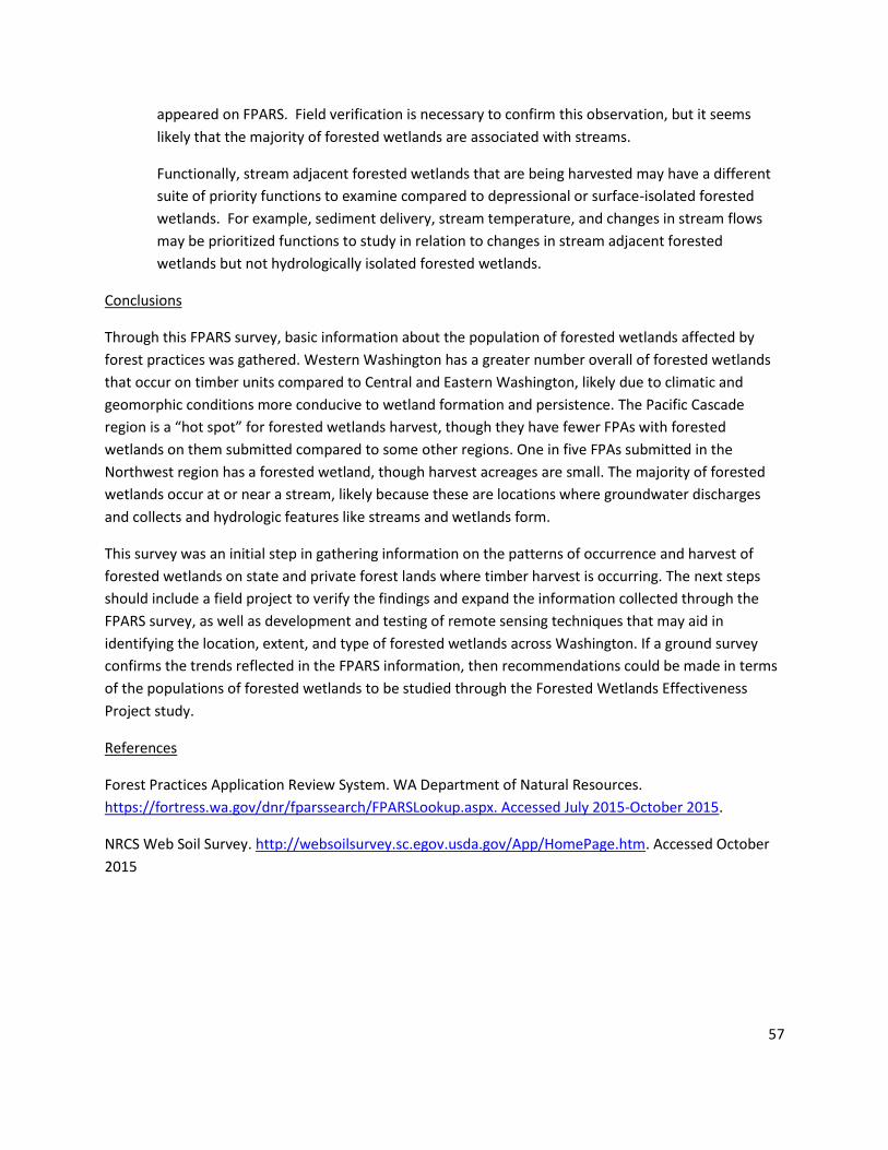
57
appeared on FPARS. Field verification is necessary to confirm this observation, but it seems
likely that the majority of forested wetlands are associated with streams.
Functionally, stream adjacent forested wetlands that are being harvested may have a different
suite of priority functions to examine compared to depressional or surface-isolated forested
wetlands. For example, sediment delivery, stream temperature, and changes in stream flows
may be prioritized functions to study in relation to changes in stream adjacent forested
wetlands but not hydrologically isolated forested wetlands.
Conclusions
Through this FPARS survey, basic information about the population of forested wetlands affected by
forest practices was gathered. Western Washington has a greater number overall of forested wetlands
that occur on timber units compared to Central and Eastern Washington, likely due to climatic and
geomorphic conditions more conducive to wetland formation and persistence. The Pacific Cascade
region is a “hot spot” for forested wetlands harvest, though they have fewer FPAs with forested
wetlands on them submitted compared to some other regions. One in five FPAs submitted in the
Northwest region has a forested wetland, though harvest acreages are small. The majority of forested
wetlands occur at or near a stream, likely because these are locations where groundwater discharges
and collects and hydrologic features like streams and wetlands form.
This survey was an initial step in gathering information on the patterns of occurrence and harvest of
forested wetlands on state and private forest lands where timber harvest is occurring. The next steps
should include a field project to verify the findings and expand the information collected through the
FPARS survey, as well as development and testing of remote sensing techniques that may aid in
identifying the location, extent, and type of forested wetlands across Washington. If a ground survey
confirms the trends reflected in the FPARS information, then recommendations could be made in terms
of the populations of forested wetlands to be studied through the Forested Wetlands Effectiveness
Project study.
References
Forest Practices Application Review System. WA Department of Natural Resources.
https://fortress.wa.gov/dnr/fparssearch/FPARSLookup.aspx. Accessed July 2015-October 2015.
NRCS Web Soil Survey. http://websoilsurvey.sc.egov.usda.gov/App/HomePage.htm. Accessed October
2015
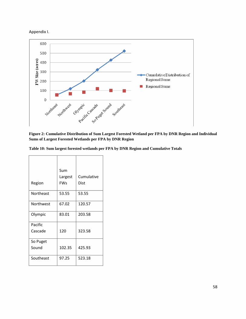
58
Appendix I.
Figure 2: Cumulative Distribution of Sum Largest Forested Wetland per FPA by DNR Region and Individual
Sums of Largest Forested Wetlands per FPA by DNR Region
Table 10: Sum largest forested wetlands per FPA by DNR Region and Cumulative Totals
Region
Sum
Largest
FWs
Cumulative
Dist
Northeast 53.55 53.55
Northwest 67.02 120.57
Olympic 83.01 203.58
Pacific
Cascade 120 323.58
So Puget
Sound 102.35 425.93
Southeast 97.25 523.18

59
Table 11: Sum and Average acreage of largest forested wetlands per FPA , separated by stream adjacency
Sum
Acreage
of
Largest
FW per
FPA
Average
Acreage
of Largest
FW per
FPA
Stream adjacent 429.8 4.255446
Not Stream
adjacent 78.42 2.704138