for the former nellis small arjw range -...
TRANSCRIPT

US Army Corps of Engineers Rock Island District
Defense Environmental Restoration Program For
Formerly Used Defense Sites Ordnance and Explosives
Archives Search Report
FINDINGS for the former
NELLIS SMALL ARJW RANGE LAS VEGAS, NEVADA
Project Number JO9NVO51001
July 1996
Moving Target Ranges at the Las Vegas Gunnery School
DEFENSE ENVIRONMEXTAL RESTORATION PROGRAM
for FORMERLY USED DEFENSE SITES
FINDINGS
ORDNANCE AND EXPLOSIVES ARCHIVES SEARCH REPORT
for the former NELLIS SMALL ARMS RANGE
LAS VEGAS, NEVADA PROJECT NUMBER JOSNVO51001
July 1996
Prepared For U.S. Army Engineering and Support Center, Huntsville
ATTN: CEHNC-OE P-0. BOX 1600
Huntsville, Alabama 35807-4301
Prepared By U.S. Army Corps. of Engineers
Rock Island District ATTN: CENCR-ED-DO
P.O. Box 2004 Rock Island, Illinois 61204-2004
and
U.S. Army Defense Ammunition Center and School ATTN: SIOAC-ESL
Savanna, Illinois 61074-9639
ORDNANCE AND EXPLOSIVES ARCHIVES SEARCH REPORT
for the former NELLIS SMALL ARMS RANGE
LAS VEGAS, NEVADA PROJECT NUMBER JO9NVO51001
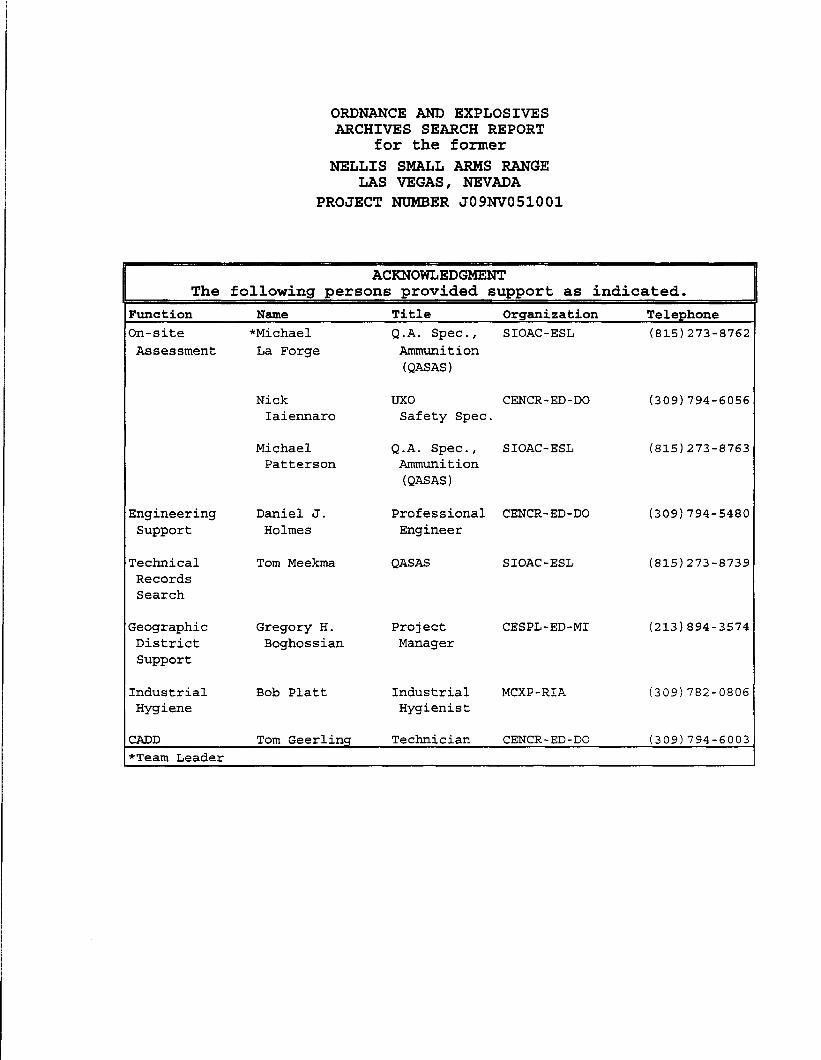
ACKNOWLEDGMENT The following persons provided support as indicated.
knction Name Title Organization Telephone In-site Assessment
Zngineering Support
rechnical Records Search
Zeographic District Support
Industrial Hygiene
*Michael La Forge
Nick Iaiennaro
Michael Patterson
Daniel J. Holmes
Tom Meekma
Gregory H. Boghossian
Bob Platt
Q.A. Spec., SIOAC-ESL (8151273-8762 Ammunition (QASAS)
TJXO CENCR-ED-DO (309) 794-6056 Safety Spec.
Q.A. Spec., SIOAC-ESL (8151273-8763 Ammunition (QASAS)
Professional CENCR-ED-DO (309) 794-5480 Engineer
QASAS SIOAC-ESL (815)273-8739
Project Manager
CESPL-ED-MI (2131894-3574
Industrial MCXP-RIA (309) 782-0806 Hygienist
ZADD Tom Geerling Technician CENCR-ED-DO (309) 794-6003 rTeam Leader

1.
2.
3.
4.
5.
6.
ORDNANCE AND EXPLOSIVES ARCHIVES SEARCH REPORT
for the former NELLIS SMALL ARMS RANGE
LAS VEGAS, NEVADA PROJECT NUMBER JO9NVO51001
FINDINGS
TABLE OF CONTENTS
Section
INTRODUCTION...............................
it: Subject and Purpose Scope
PREVIOUS INVESTIGATIONS/PROJECTS........
:: 1994 Preliminary Assessment Other Investigations
SITE DESCRIPTION.........,..............
2 Existing Land Usage Climatic Data
:: Topography Geology and Soils
e. Hydrology f. Natural Resources 53. Historical/Cultural Resources
. .
. .
HISTORICAL ORDNANCE PRESENCE..............
it: Chronological Site Summary Ordnance Related Records Review
C. Interviews with Site Related Personnel
SITE ELIGIBILITY......................-...
:: Confirmed Formerly Used Defense Site Potential Formerly Used Defense Site
VISUAL SITE INSPECTION....................
E: General Procedures and Safety Area A: Buried 37mm HE Area
2 Area B: Bomb Jettison Area Area C: Bomb Jettison Area
e. Area D: Bomb Jettison Area f. Area E: Bomb Jettison Area
. .
. .
. I
. .
. .
, . .
, . .
. . .
. .
. I
. ,
. .
, . .
, . .
. .
. .
. .
Page
. . . 1
. . . -2
. . . 2
, . . . . , . . 6 . . . .
. . . . . . . . . . . . 9
. . . . . . . . . . . . 9

7. EVALUATION OF ORDNANCE HAZARDS. . . . . . . . . . .
8.
2 General Procedures Area A: Buried 37mm Area
:: Area B: Bomb Jettison Area Area C: Bomb Jettison Area
e. Area D: Bomb Jettison Area f. Area E: Bomb Jettison Area
SITE ORDNANCE TECHNICAL DATA... . . . . .
a. End Item Technical Data b. Chemical Data of Ordnance Fillers
9. OTHER ENVIRONMENTAL HAZARDS...........
. . . . .
. . . .
Waste
. . .
. . .
. . .
. . .
. . .
. . .
. . .
. . .
. . .
. .
. .
. .
;: Hazardous, Toxic, and Radiological Building Demolition/Debris Removal
APPENDICES
A. REFERENCE SOURCES ....................................... B. GENERAL REFERENCES AND ABSTRACTS ........................ C. GLOSSARY ................................................ D. TEXTS/MANvALS ........................................... E. REPORTS/STUDIES ......................................... F. LETTERS/MEMORANDUMS/MISCELLANEOUS ITEMS ................. G. REAL ESTATE DOCUMENTS ................................... H. NEWSPAPERS/JOURNALS ..................................... I. INTERVIEWS .............................................. J. PRESENT SITE PHOTOGRAPHS ................................ K. HISTORICAL PHOTOGRAPHS .................................. L. REFERENCE MAPS/DRAWINGS ................................ M. ARCHIVES SEARCH REPORT CORRESPONDENCE ................... N. REPORT DISTRIBUTION LIST......................-.- .......
TABLES
2-1 DERP-FUDS PRELIMINARY ASSESSMENT PROJECTS ............... 3-1 CURRENT LAND USAGE ...................................... 3-3 NATURAL RESOURCES ....................................... 8-1 AMMUNITION USED AND EXPLOSIVES/CHEMICAL FILLERS .........
11
13
16
8-2 CHEMICAL DATA OF EXPLOSIVE/ORDNANCE FILLERS.............

REPORT PLATES
1. SITE MAP ................................................ 2. FACILITY LAYOUT CIRCA 1943 .............................. 3. PROJECT AREAS ........................................... 4. CURRENT OWNERSHIP/PHOTO LOCATIONS .......................

ORDNANCE AND EXPLOSIVES ARCHIVES SEARCH REPORT
For the former NELLIS SMALL ARMS RANGE
LAS VEGAS, NEVADA PROJECT NUMBER JO9NVO51001
1. INTRODUCTION
a. Subject and Purpose
(1) This report presents the findings of an historical records search and site inspection for ordnance and explosives (OE) presence located at the former Nellis Small Arms Range. The investigation was performed under the authority of the Defense Environmental Restoration Program for Formerly Used Defense Sites (DERP funs) .
(2) The investigation focused on 36,378.28 acres of land that was used initially by the Army Air Force as a ground gunnery range during WW-II and later by the Air Force as an emergency jettison area and explosive ordnance disposal (EOD) area.
(3) The purpose of this investigation was to characterize the site for potential OE contamination, to include conventional ammunition and chemical warfare material (CWM) . The investigation was conducted by experienced ordnance experts through thorough evaluation of historical records, interviews, and on-site visual inspection results.
b. Scope
(1) This report presents the site history, site description, real estate ownership information, and confirmed ordnance presence (prior to and after site closure), based on available records, interviews, site inspections, and analyses. The analyses provide a complete evaluation of all information to assess current day potential ordnance contamination, where actual ordnance presence has not been confirmed.
(2) For the purpose of this report, OE contamination consists of live ammunition, live ammunition components, CWM, or explosives which have been lost, abandoned, discarded, buried, fired or thrown from demolition pits or burning pads. These items were either manufactured, purchased, stored, used, and/or disposed of by the War Department/Department of Defense. Such ammunition/components are no longer under accountable record control of any DOD organization or activity.
(3) Expended small arms ammunition t.50 cal or smaller) is not considered OE contamination. OE further includes
I

"explosive soil" which refers to any mixture in soil, sands, clays, etc., such that the mixture itself is explosive. Generally, 10 percent or more by weight of secondary explosives in a soil mixture is considered explosive soil.
2. PREVIOUS INvESTIGATI~N~~PR~J~~~S
a. 1994 Preliminary Assessment
(1) A Preliminary Assessment of the Nellis Small Arms Range was conducted under the Defense Environmental Restoration Program, Formerly Used Defense Sites (DERP FUDS) by th;,C;;g; of Engineers, Los Angeles Division (see reference B-l). time, the Findings and Determination of Eligibility (FDE), dated 30 August 1994, concluded that 36,378.28 acres had been formerly owned or used by the Army Air Force/Department of Defense.
(2) The FDE concluded that there were eligible categories under the DERP/FUDS program. Since the site was found to have been used as a training, demolition, and jettison area, an Ordnance and Explosives (OE) project was recommended, DERP FUDS Project Number JO9NVO51001, which is the subject of this report (see document E-3).
Present
JO9NVO51001 OE SI Ordnance and See plate 3 Explosives
BD/DR None Recommended
HTRW None
b. Other Investigations
No other investigations or studies relevant to DERP-FUDS were discovered during this Archives Records Search.
3. SITE
a. Existing Land Usage
(1) The former Nellis Small Arms Range is located in Clark County, 6 miles northeast of Las Vegas, Nevada and 2 miles north of Nellis Air Force Base.
2

(2) Part of the property is used by the U.S. Fish and Wildlife Service as part of the Desert Game Range; the remainder of the property is owned by the Bureau of Land Management and is used primarily for public access and recreational activity. An active U.S. Air Force small arms range abuts this area on the southeast corner but is not considered part of the FUDS (see plate 3).
(3) Table 3-l shows current land usage.
TABLE 3-l CURRENT LAND USAGE
AREA FORMER PRESENT PRESENT SIZE/ COMMENTS USAGE OWNER USAGE ACRES
A 37mm Burial BLM Wildlife 2,782 See plates 3,4 Area Mgmt.
B Bomb FWS Wildlife 9,267 See plates 3,4 Jettison Mgmt.
Area
C Bomb BLM Wildlife 8,016 See plates 3,4 Jettison Mgmt.
Area
D Bomb BLM Recreation 1,094 See plates 3,4 Jettison
Area
E Bomb BLM Recreation 15,219.28 See plates 3,4 Jettison
Area
b. Climatic Data
(1) Material in paragraphs 3-b.(2) through (4) was extracted primarily from the Local Climatological Data, Annual Summary With Comparative Data for Las Vegas, Nevada, dated 1993 (see reference B-7).
(2) Clark County is located in the southwestern portion of the state. Weather factors for the Las Vegas recording station are used in this assessment. The factors that determine weather patterns include location of Nevada on the eastern, lee weather patterns include location of Nevada on the eastern, lee side of the Sierra Nevada Mountains, side of the Sierra Nevada Mountains, prevailing winds from the prevailing winds from the west that drop precipitation on the western side of the Sierras, west that drop precipitation on the western side of the Sierras, and wild local variations due to differences in topography and and wild local variations due to differences in topography and elevation.

(3) The annual precipitation averages 4.21 inches (1964-1993 avg. mean). The wettest months are usually March and January. The months with the least amounts of precipitation are May and June (see reference B-8).
(4) The average temperature ranges from daily minimums in January and December of 32.7 to 33.6' F to daily mean high temperatures of 83.5-89.8' F in June, July, and August. The lowest temperature observed was 8'F in January and the highest temperature was 116' F in July (see reference B-8). Mean number of days with temperatures over 90' F is 132. Mean number of days 32O F and below is less than one-half (see reference B-7).
(5) The average snowfall each winter is from a trace to up to 16.7 inches. The relative humidity averages from 21 to 40 percent throughout the course of the day (see references B-7 and B-8).
(6) Flooding, especially flash flooding, is likely to occur in the area of the site after thunderstorms due to the topography and soil consistencies (see reference B-7).
C. Topography
(1) (1) Clark County lies on the southern edge of the state Clark County lies on the southern edge of the state and is part of the Great Basin. and is part of the Great Basin. Average elevations in the area Average elevations in the area of the site are from 3,000 to 7,800 feet. of the site are from 3,000 to 7,800 feet. The terrain varies The terrain varies quite sharply from steep, quite sharply from steep, craggy mountains to broad alluvial fans craggy mountains to broad alluvial fans on the valley floor. on the valley floor.
(2) The site is traversed by gullies, canyons, and arroyos making transportation difficult. Roads are generally jeep tracks and impassable during certain portions of the year.
d. Geology and Soils
(1) Material in paragraphs 3.d.(2) and 3.d.(3) was extracted from the current Soil Survey of Clark County, Nevada (see reference B-40).
(2) Regional Geology/Soils
(a) The geology of Clark County is generally categorized by beginning with the sedimentary formations in the mountains that have gravitated to the basin floor. This in turn becomes alluvial fan Piedmont characterized by coalescing fans dissected by numerous drainage channels. Sedimentary formations of dolomite and limestone from the early Cambrian to the early Devonian are present, with the occasional appearance of interbedded quartzite, and shale beds. The Tertiary rock in the mountains ringing the site area are mainly basalt, rhyolite and latite and classified as volcanic extrusions. The valley floors
4

that make up the main portion of the site are quarternary in nature, made up of a detritus from the bedrock areas carried by intermittent flash flooding to the margins of valleys and alluvial fans. Larger amounts of coarse debris are deposited along the edges of dry watercourses (see reference B-40).
(b) The soil is of all sizes of rock debris ranging from clay-sized fragments to boulders. The soil is not suited for agricultural purposes and lack of water kills all but the hardiest desert shrubs.
(3) Site Specific Geology/Soils
The soil on this site is Weiser extremely gravelly fine sandy loam with 2 to 8 percent slopes (see reference B-40). the Weiser series consists of very deep, well drained soils on erosional fan remnants. The soil is largely derived from limestone. About 80 percent of this soil type is actually small pebbles. A dark desert varnish is found on the exposed surfaces of these rock fragments. Calcium carbonate content ranges 40 to 60 percent, confirming the limestone foundation of this soil. The fine earth fraction averages fine sandy loam or sandy loam and has a clay content of 5 to 18 percent. The profile is moderately or strongly alkaline. This is the only soil type on the site.
e. Hydrology
The 4.21 inch average rain fall for the Las Vegas area is a reliable estimate for this area due to proximity of the site to Las Vegas. (see reference B-11). Surface water on this site is runoff from the mountainous areas to the north and northeast of the site. Small springs and seeps are located in several places on the site but these are largely seasonal and provide no steady supply of water.
f. Natural Resources
(1) There are several endangered animals and plants listed as endangered species to be protected in this portion of Nevada by the Department of the Interior, U.S. Fish and Wildlife Service (see reference B-6).
(2) The following species are recognized as threatened, endangered, or sensitive by the State of Nevada or the Federal Government and are presented in tabular form in table 3-3:
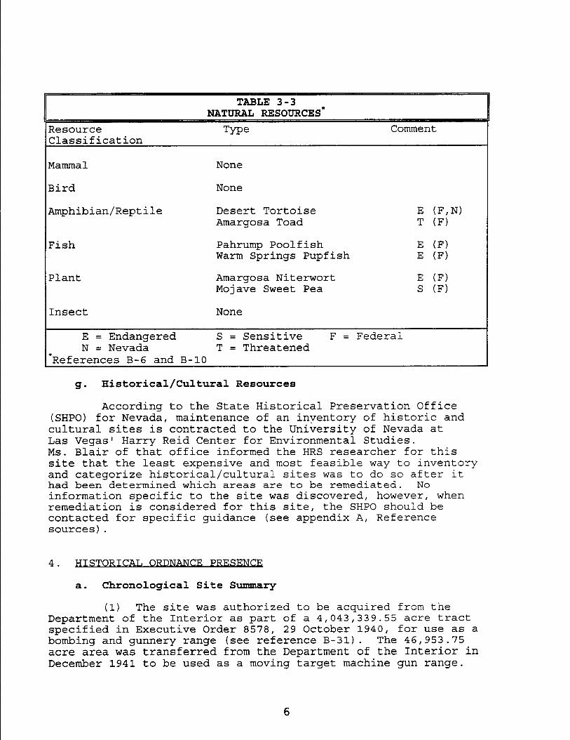
Resource Classification
TABLE 3-3 NATURAL RESOURCES*
Tme Comment
c
Mammal None
Bird None
Amphibian/Reptile Desert Tortoise E o?,N) Amargosa Toad T (F)
Fish Pahrump Poolfish E (F) Warm Springs Pupfish E (I?)
Plant Amargosa Niterwort E (F) Mojave Sweet Pea S (F)
Insect None
E = Endangered S = Sensitive F = Federal N= Nevada T = Threatened
*References B-6 and B-10
g- Historical/Cultural Resources
According to the State Historical Preservation Office (SHPO) for Nevada, maintenance of an inventory of historic and cultural sites is contracted to the University of Nevada at Las Vegas' Harry Reid Center for Environmental Studies. Ms. Blair of that office informed the HRS researcher for this site that the least expensive and most feasible way to inventory and categorize historical/cultural sites was to do so after it had been determined which areas are to be remediated. No information specific to the site was discovered, however, when remediation is considered for this site, the SHPO should be contacted for specific guidance (see appendix A, Reference sources).
4. HISTORICAT, ORDNANCE PRESENCE
a. Chronological Site Summary
(1) The site was authorized to be acquired from the Department of the Interior as part of a 4,043,339.55 acre tract specified in Executive Order 8578, 29 October 1940, for use as a bombing and gunnery range (see reference B-31). The 46,953.75 acre area was transferred from the Department of the Interior in December 1941 to be used as a moving target machine gun range.
6

Approximately 25,620 acres were relinquished to the Bureau of Land Management (BLM) in August 1954. An additional 10,758.27 acres were relinquished to the Fish and Wildlife Service in July 1961. The site was used by Air Force, Marine Corps and Navy personnel from Nellis Air Force Base and Lake Mead Base for small arms weapons ranges. The site was also used as an emergency drop area for hung bombs, wing-tip tanks and pylons. The Air Force also utilized a portion of the area as an explosive ordnance disposal area. Numerous range clearances have been conducted and are documented in appendix F. OE continues to be discovered on the site. The Air Force Small Arms Range which is adjacent to this site is active and still in use. Its acreage is not considered in this report.
b. Ordnance Related Records Review
(1) Sources checked in the search for any OE contamination included:
[a] National Archives [bl Regional Archives [cl The Military History Institute Cd] U.S. Army Center for Military History kl Emergency Ordnance Disposal (EOD) Units [f] Local Police Department bl Local Sheriff's Department [hl County Courthouse
(2) For a complete list of sources checked, see appendix A, Reference Sources.
(3) Documentation discovered in the course of the Archives Search showed that the former Nellis Small Arms Range was first envisioned before World War II for training flexible machine gunners assigned to the Las Vegas Bombing and Gunnery School (see F-l). Numerous documents refer to construction of ranges and ammunition supply and logistics matters (see F-2 to F-4) necessary to properly run a training area. Power turrets were requested in December 1941 (see F-5). References F-6 and F-7 discuss a request for the delivery of 20mm and 37mm AA guns. The use of tracer shotgun ammunition is discussed in reference F-8. The moving target ranges and numbers of students expected to be trained are discussed in reference F-9. The aforementioned documents all date from World War II. The next two references discuss the construction of a 600 yard rifle range in 1955 to be jointly shared by Nellis Air Force Base and Lake Mead Base (see F-9).
(4) Explosive Ordnance Disposal team range clearance documents exist and were carefully studied to determine areas of confirmed and potential OE contamination, as well as density of that contamination. Clearances were conducted in 1972, 1977, 1978 and 1995.

Large amounts of OE were recovered (see references F-10, F-11, F- 12, and F-13). These documents were responsible in part for the risk assessments for this site.
(5) A declaration of excess dated June 1971 details the types of munitions items that could be expected to be found on the range (see reference G-2 and map L-3). Included were practice bombs and HE rockets.
(6) Review of newspaper microfilm, clipping files, and vertical files at the Nevada Room of the Las Vegas Central Library revealed no evidence of the discovery of OE at the former Nellis Small Arms Range.
C. Interviews with Site Related Personnel
(1) CPT Swoboda, Nellis AFB EOD, had a wealth of information concerning OE at the former Nellis Small Arms Range. His unit does the range clearances on the active portions of the Nellis Range and would be the responders if ordnance was discovered in/on FWS/BLM lands, like Nellis Small Arms Range, that border the active Range. He was the officer in charge of the last range clearance of the area and his final report with OE recovered and map of their locations is at reference F-13. He stated that OE items discovered off range are recovered by Nellis ordnance personnel in the interest of public safety (see interview I-l).
(2) SSG Quinn, 259th EOD, Fort Irwin was the staff duty NC0 . SSG Quinn had no information on discovery or removal of ordnance and munitions items in the former Nellis Small Arms Range area. He acknowledged that his unit does have responsibility for the area in which Nellis Small Arms Range is located, but, in practice, leave discoveries of Air Force munitions for the Air Force's disposition. He suggested I speak with Air Force EOD personnel and gave me a POC (see interview I-l). He had no other pertinent information (see interview I-2).
(3) Dr. Wilman is the Staff Historian for WTC and is very familiar with all aspects of the Nellis Range Complex. She was familiar with instances of OE being discovered in the area where Nellis Small Arms Range is located. She has intensively searched the archives for us in this respect after prior coordination with the HRS team's Mr. Meekma. She directed us to
8

EOD Captain Swoboda (interview I-l) (see interview I-3).
(4) Mr. Cook is currently an employee of the Bureau of Land Management in Las Vegas and is quite familiar with the property in question at the former Nellis Small Arms Range. He has visited the property several times in the course of his duties and has never seen any evidence of OE in the area. He is familiar with OE from his time in the military and spoke knowledgeably about military activities in the surrounding areas including other FUDS sites now under study (see interview I-4).
5. SITE
a. Confirmed Formerly Used Defense Site
(1) Former land usage by the Army was previously confirmed for the entire 36,378.28 acre site as summarized in section 4 of this report.
(2) There are no recapture or restricted use documents on record for the former Nellis Small Arms Range.
b. Potential Formerly Used Defense Site
No previously unknown potential Formerly Used Defense Sites were identified by the site inspectors during the course of the visual inspection and review of historical documents.
6. VISUAJ, SITE INSPECTION
a. General Procedures and Safety
(1) During the period 15-21 February 1996, members of the Site Inspection (SI) team traveled to Nevada to assess several FUDS including the portion of the former Nellis Small Arms Range returned to the public domain. The team did not visit the fenced, active range which is not a part of this report. The primary task of the SI team was to assess OE presence and potential due to the usage of the site as a machine gun range and emergency jettison area for the Las Vegas Bombing and Gunnery Schoolduring World War II. Contamination from present day usage of ordnance in areas adjacent or in the sky above the FUDS is not within the purview of the DERP-FUDS program and must be addressed separately.
(2) A site safety plan was developed and used by the SI team to assure an injury-free site inspection of the Former Nellis Small Arms Range. A briefing was conducted prior to the SI which stressed that OE would only be handled by military EOD personnel. Site safety and strict adherence to nonintrusive
9

investigation methods were maintained by the inspection team at all times during the on-site inspection.
(3) Prior to the site visit, a thorough review was made of available reports, historical documents, texts, and technical ordnance manuals (see materials referenced in Appendix A gathered during the ASR historical records search). This review was made to ensure team awareness of potential ordnance types and hazards.
(4) The actual inspection of the former Nellis Small Arms Range began on 16 February 1996, when the SI team visited the area of the site.
b. Area A: Buried 37mm HE Area
(1) The site was surveyed with the aid of a 4-wheel-drive vehicle and existing maps and drawings provided by Nellis EOD (see map L-3).
(2) The SI team first surveyed the portion of the site indicated as a potential ammunition burial site for 37mm HE by the INPR. This survey was conducted on foot with all appropriate cautions taken to avoid injury and heat fatigue. No of evidence of OE was noted. The area was walked by the assessment team three abreast, taking care to carefully inspect gullies similar to the ones mentioned in the EOD reports of 37mm found in the area (see plate 3, photograph J-l and map L-3). Other OE items have also been discovered in this area (see reference F-13) but are most likely illicit dumps by disaffected individuals.
C. Area B: Bomb Jettison Area
This area is mountainous and not vehicle accessible; it was not inspected on foot. EOD personnel who have surveyed the area by helicopter verify the presence of OE such as rockets, practice bombs, and expended wing-tip tanks.
d. Area C: Bomb Jettison Area
This area is mountainous and not vehicle accessible; it was not inspected on foot. EOD personnel who have surveyed the area by helicopter verify the presence of OE such as rockets, practice bombs and expended wing-tip tanks.
e. Area D: Bomb Jettison Area
This area is mountainous and not vehicle accessible; it was not inspected on foot. EOD personnel who have surveyed the area by helicopter could not verify the presence of OE such as rockets, practice bombs and expended wing-tip tanks but think it likely due to it's designation as an emergency drop area and proximity to the air base.
10

f. Area E: Bomb Jettison Area
This large area was walked east to west by the assessment team members three abreast. Three of the former moving target berms are located on the southern edge of the site. No evidence of OE was noted. This area had large numbers of expended .50 caliber machine gun bullets from its use as an moving target machine gun range (see photographs J-2 and J-3). This area has had one inert Ml17 practice bomb removed by Nellis Air Force Base EOD (See reference F-13).
7. )DS
a. General Procedures
(1) The site was evaluated to determine confirmed, potential, or uncontaminated ordnance presence. Confirmed ordnance contamination is based on verifiable historical evidence or direct witness of ordnance items. Verifiable historical records evidence consists of ordnance items located on site and documented by the local bomb squad, Air Force and Army Explosive Ordnance Disposal teams, newspaper articles, correspondence, current findings, etc. Direct witness of ordnance items consists of the inspection team directly locating ordnance items by visual inspection. Additional field data is not needed to identify a confirmed subsite.
(2) Potential ordnance contamination is based on a lack of confirmed ordnance. Potential ordnance contamination is inferred from records or indirect witness. Inference from historical records would include common practice in production, storage, usage, or disposal, at that time, which could have allowed present day ordnance contamination. Potential ordnance contamination could also be based on indirect witness or from present day site features. Additional field data is needed to confirm potential ordnance subsites.
(3) Uncontaminated ordnance subsites are based on a lack of confirmed or potential ordnance evidence. Historical records evidence and present day site inspections do not indicate confirmed or potential ordnance contamination. There is no reasonable evidence, either direct or inferred, to suggest present day ordnance contamination. Additional field data is not needed to assess uncontaminated ordnance subsites.
b. Area A: Buried 37mm HE Area
(1) Based on the site visual inspection, review of historical documents, and reports of found OE since site closure,
11

this area is considered contaminated in accordance with the standards of paragraph 7.a. (1).
(2) OE has been recovered from this site by Nellis Air Force Base EOD personnel but the precise location was not detailed on a clearance map. 37mm HE projectiles show up after heavy rains and will probably continue to surface due to weather or real estate development. A portion of this area, section 17, also may have served as an EOD demolition area (see map L-3). The area must be treated as contaminated due to pit kick-outs, buried misfires, and the common practice of illicit burial of items.
C. Area B: Bomb Jettison Area
(1) Based on review of historical documents, and interviews with Nellis Air Force Base EOD personnel this area is considered contaminated in accordance with the standards of paragraph 7.a.(l).
(2) OE has been noted on the ground by EOD personnel doing aerial surveys of the area. The rugged, nearly inaccessible terrain complicates disposal and removal by Nellis AFB EOD.
d. Area C: Bomb Jettison Area
(1) Based on review of historical documents and interviews with Nellis Air Force Base EOD personnel this area is considered contaminated in accordance with the standards of paragraph 7.a.(l).
(2) OE has such as practice bombs have been noted on the ground by EOD personnel doing aerial surveys of the area. The rugged, nearly inaccessible terrain complicates disposal and removal by Nellis AFB EOD.
e. Area D: Bomb Jettison Area
(1) This area was broken out from Area C based on its accessibility. As a result of the site visual inspection, review of historical documents, and common practices of the time, this area is considered potentially contaminated in accordance with the standards of paragraph 7.a. (2).
(2) No OE was noted on the site. Individuals familiar with the site have found no evidence of OE contamination (see interviews I-l and I-4). This area is adjacent to known contaminated and active use areas. This area could have been utilized if required to drop hung bombs and rockets, wing-tip tanks and weapons pylons. It would have been common practice to utilize the area as an emergency drop site; the possibility for contamination by OE exists and must be taken into consideration.
12
f. Area E: Bomb Jettison Area
(1) Based on the site visual inspection, review of historical documents, and reports of found OE since site closure, this area is considered potentially contaminated in accordance with the standards of paragraph 7 .a.(2).
(2) Although three of the moving targets berms are located in this area, expended small arms are not the primary focus of study in this area since it is not considered OE. No OE was noted on the site during the assessment. One inert Ml17 practice bomb has been removed by EOD and is considered scrap metal and not OE. However, since the area is adjacent to known contaminated areas and an active training range the potential for buried and impacted OE items exists in this area. This area was also available for emergency jettisoning of bombs and racks and may be contaminated with OE.
8. SITE ORDN?QJCF, TECHNICATI DATA
a. End Item Technical Data
(1) There is historical evidence to indicate that ordnance was used at the Nellis Small Arms Range over a 20-year period.
(2) Table 8-1 is a listing of OE items most likely to have been expended for gunnery training based on the scopes of the training missions and the timeframe 1941-1965as well as observed OE on-site:
TABLE 8-1
Cartridge, -30 caliber, Ml Ball Lead antimony Carbine Ml6 Tracer Tracer composition
Cartridge, .45 caliber, M1911, Ball 5.6 grains Powder 4648 Pistol Copper Plated Steel
Cartridge, .50 caliber, M2, Ball Soft steel/lead
Bullet
Machine Gun M2, AP Tungsten chrome steel
13

AN-MK 23 MK4
AN-MK43 MK 4
AN-MK 5 MK4
MK 105 MK4
MK 76 MK 4
c
TABLE 8-1 AMMUNITION USED AND EXPLOSIVES/CHEMICAL FILLERS
rype Model Projectile, 20mm HE1 MK IV
Filler/Weight .0171 lb. Tetryl .0072 lb. Intend. mix.
Projectile, 37mm, HE-T
Fuze
Srenade, Incendiary
Narhead, Rocket 2.75"
M54
M56 PD
AN-Ml4
M229 HE
.lO lb. Tetryl
.025 lb. Tracer Comp. Tetryl booster
1.75 lbs. thermite
15.5 lbs. Comp. B
Block, Demolition
Block, Demolition
Cord, Detonating
M3
M4
2.25 lb. Comp. C-3
.50 lb. Comp. C-3
7 lb./100 feet PETN
Bomb, Practice 3 lb. w/signal
Cast iron 10 gm zinc oxide 3 gm black powder 3 gm smokeless powder Titanium tetrachloride
Bomb, Practice 4.5 lb. w/signal
Cast lead 10 gm zinc oxide 3 gm black powder 3 gm smokeless powder Titanium tetrachloride
Bomb, Practice 2.68 lb. w/signal
Zinc Alloy 10 gm zinc oxide 3 gm black powder 3 gm smokeless powder Titanium tetrachloride
Bomb Practice 5 lb. w/signal
Bomb, Practice 25 lb. w/signal
Sheet steel 10 gm zinc oxide 3 gm black powder 3 gm smokeless powder Sheet steel 10 gm zinc oxide 3 gm black powder 3 gm smokeless powder Titanium tetrachloride
14

TABLE 8-1
Bomb, Practice 100 lb. w/signal
M38A2 Sheet steel 10 gm zinc oxide 3 gm black powder 3 gm smokeless powder Titanium tetrachloride water/sand mix
I Rocket, 5", HE MK 1 Mod 0 8.6 lbs. TNT
b. Chemical Data of Ordnance Fillers
Table 8-2 has been developed to establish a list of typical explosive/chemical compounds used in the ordnance and chemical items cited in Table 8-1.
Table 8-2 CHEMICAL DATA OF EXPLOSIVE/ORDNANCE FILLERS
EXPLOSIVE MATERIEL SYNONYM(S) CHEMICAL FORMULA Smokeless Powder PNH Powder Various percentages of: Nitrocellulose Nitrocotton C3H5(0N02)3
Dinitrotoluene DNT C@$C$ (NO2) 2
Dibutylphthalate Gelling Agent C6H4 (CO2CqHg) 2
Diphenylamine DPA; Stabilizer (C6H5 12N.H
Black Powder 74% Potassium
Nitrate 11% Sulfur 16% Charcoal
Niter, Salt Peter KNo3 S C
TNT 2,4,6 Trinitrotolulene C&/=3 (NO21 3
RDX %-&%O,
15
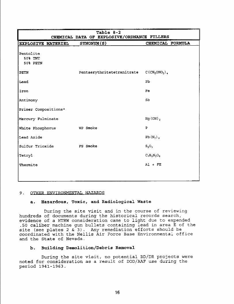
Pentaerythritetetranitrate C ( CH,ONO, ) 4
Pb
Fe
Sb
WP Smoke
Hg (ON) 2
P
Pb(N,),
Table 8-2 CHEMICAL DATA OF EXPLOSIVE/ORDNANCE FILLERS
EXPLOSIVE MATERIEL SYNONYM IS) CHEMICAL FORMULA
Pentolite 50% TNT 50% PETN
PETN
Lead
Iron
Antimony
Primer Compositions*
Mercury Fulminate
White Phosphorus
Lead Azide
Sulfur Trioxide
Tetryl
FS Smoke s2°3
GH,N,O,
Thermite Al + FE
9. -R ENVIRONMENTAL HA7rrsRDS
a. Hazardous, Toxic, and Radiological Waste
During the site visit and in the course of reviewing hundreds of documents during the historical records search, evidence of a HTRW consideration came to light due to expended
50 caliber machine gun bullets containing lead in area E of the site (see plates 2 & 3). Any remediation efforts should be coordinated with the Nellis Air Force Base Environmental office and the State of Nevada.
b. Building Demolition/Debris Removal
During the site visit, no potential BD/DR projects were noted for consideration as a result of DOD/AAF use during the period 1941-1963.
16