for review only - rdo.psu.ac.thrdo.psu.ac.th/sjstweb/ar-press/2018may/22.pdf · pemetaan (jupem)....
TRANSCRIPT

For Review O
nly
Statistical Analysis of Topographic Characteristics and Nest-
site Preference Analysis of the White-Bellied Sea-Eagle (Haliaeetus leucogaster) in Penang National Park, Malaysia.
Journal: Songklanakarin Journal of Science and Technology
Manuscript ID SJST-2016-0046.R1
Manuscript Type: Original Article
Date Submitted by the Author: 01-Mar-2017
Complete List of Authors: Dauda, Taofik; Institute of Agricultural Research and Training, Obafemi
Awolowo University Mohd Sah, Shahrul Anuar; Universiti Sains Malaysia, School of Biological Sciences Masduqi, M., Siyafiq; Universiti Sains Malaysia, School of Biological Sciences W.I., Wan Mohd Muhiyuddin; Universiti Sains Malaysia, School of Humanities. A.L., Nurul Salmi; Universiti Sains Malaysia, School of Biological Sciences
Keyword: Agricultural and Biological Sciences, Environmental and Natural Resources
For Proof Read only
Songklanakarin Journal of Science and Technology SJST-2016-0046.R1 Dauda
For Review O
nly
1
Statistical Analysis of Topographic Characteristics and Nest-site
Preference of the White-Bellied Sea-Eagle (Haliaeetus leucogaster) in
Penang National Park, Malaysia.
T. O. Dauda 1,2*
A. M.S. Shahrul 1,3
, Syafiq Masduqi, M.1
Wan Mohd Muhiyuddin, W. I.4
and Nurul Salmi, A.L.1.
1. School of Biological Sciences, Universiti Sains Malaysia, Pulau, Penang, 11800, Malaysia.
2. Institute of Agricultural Research and Training, Obafemi Awolowo University, PMB 5029,
Ibadan, Nigeria.
3. Center for Marine and Coastal Studies, Universiti Sains Malaysia, 11800, Penang, Malaysia
4.School of Humanities, Universiti Sains Malaysia, 11800, Penang, Malaysia.
* Corresponding author – [email protected] Telephone - +60173276774
The corresponding author is on the TWAS - USM Post Doctoral Fellowship at 1 above
Abstract
Penang National Park was surveyed to model White-Bellied Sea-Eagle’s (WBSE) nest
sites selection using Geographic Information System of the study site (latitude N8250′
and longitude E011000′ ). Using 2 habitat variables (Topographic and disturbance) nest-
site selection analysis was carried out to examine significant difference between the sites
used by WBSE. Digital elevation model (DEM) showed that the study area was
characterized by high elevation (4500) with pockets of low elevation at the edges. Higher
percentages of the elevation clusters were obtained at southern region of the study area
(mean elevation = 92m) and it is significantly lower than the mean elevation of the entire
Park (147). The average slope of the nest sites (22.5 ± 7.0°) was significantly higher than
the general average slope of random points (18.6 ± 9.4°) in the entire Park. The
occupation-model gives a parsimonious prediction of the WBSE population in an area for
biodiversity conservation.
Keywords. ASPECT, slope, ruggedness, proximity, regrowth± 6.3m
Introduction
Haliaeetus leucogaster (White Belly Sea Eagle -WBSE) which prey on animal from
aquatic and marine environment can be used to measure eco-system stability (Dennis et
Page 2 of 22
For Proof Read only
Songklanakarin Journal of Science and Technology SJST-2016-0046.R1 Dauda
123456789101112131415161718192021222324252627282930313233343536373839404142434445464748495051525354555657585960
For Review O
nly
2
al., 2011). In Malaysia, WBSE occupies coastal environment including coastal
dipterocarp forest and other Island group (Wiersma and Richardson 2009). Habitat-
association approach to ecological study has been found inevitable to conservation and
management (Johansson, 2001). Habitat selection analysis was widely employed to
understudy and manage wildlife resources. Habitat selection theory (HST) has been
formed based on the fact that animals have predictable habitat preferences which form
part of their identity otherwise known as ‘niche’ (Jones, 2001). It (habitat selection) is
also the foundation for the use of statistical models in assessing multivariate species-
habitat relationships (Karl et al., 2000; Vogiatzakis, 2003). Limited studies are available
on habitat selection (particularly nest site selection) by raptors in Malaysia since early
1980. These studies include, Andrew and Mosher (1982); Marks (1986); Hayward and
Escano (1989). However, with advancement in computer programme and Geographic
information system (GIS), such studies have become more quantitative (Suarez et al.,
2000; Bisson et al., 2002; Tapia et al., 2007).
Geographical Information Systems (GIS) organize, synthesize and analyze habitat
features from several sources relative to species or breeding site locations and other
physiographic data. This thus enhances the understanding of both spatial and non-spatial
relationships (Mathieu et al., 2006). This approach would allowed the prediction of
species requirements when designing strategies for the conservation and management of
endangered species like WBSE (Suarez et al., 2000). WBSE are known to construct and
re-use nest in tall trees in coastal and near coastal areas of Penang National Park.
However, little or no known objective study on the nest site preference analysis of WBSE
in Penang National Park and it’s environ has been conducted. Nest-site selection analysis
Page 3 of 22
For Proof Read only
Songklanakarin Journal of Science and Technology SJST-2016-0046.R1 Dauda
123456789101112131415161718192021222324252627282930313233343536373839404142434445464748495051525354555657585960

For Review O
nly
3
of the species may provide useful information on the relationships between this species
and its environment. Such relationship would be useful for conservation and management
strategies especially in the phase of dynamic habitat status. The main objective of this
study was thus to analyze the nest-site characteristics and habitat preference by the
White-bellied sea eagle in Penang National Park using GIS.
Materials and Methods
Study area
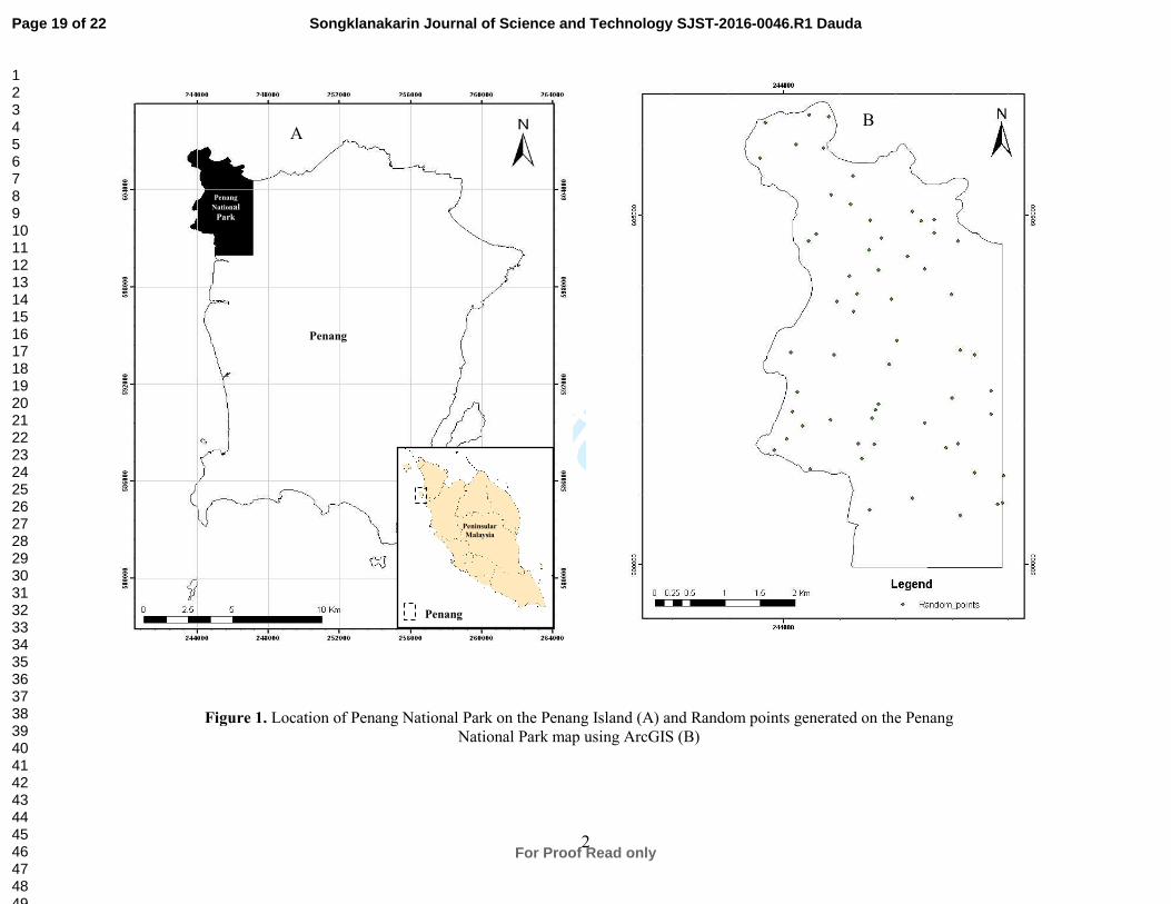
This study was carried out at Penang National Park (latitude N8250′ and longitude
E011000′ - Figure 1A) between December 2007 and July 2009. It covers an
approximately 2562.963 ha (1182 ha of land - primarily coastal hill dipterocarp forest,
coastal mangrove forest, sandy beaches and rocky shores and 1381 ha of sea areas –
(Yusop, 2004). Most of the land areas are made up of granite rocks (Chan et al., 2003).
The lowlands are narrow and small in size, occupying only the immediate coastal areas
on the north and the west of the Penang National Park. The reserve was gazetted as
Permanent Forest Reserve (PFR) under the Forestry Ordinance 1928 and as national park
since April 2003. The vegetation cover of the study area include, Dipterocarpaceae,
Leguminosae, Apocynaceae and Burseraceae. Some woody/tree species found in the
area were Shore curtisi (Seraya), Hope asp (Resak) and Agathis dammara (Damar
minyak).
Page 4 of 22
For Proof Read only
Songklanakarin Journal of Science and Technology SJST-2016-0046.R1 Dauda
123456789101112131415161718192021222324252627282930313233343536373839404142434445464748495051525354555657585960

For Review O
nly
4
Nest-site Survey and GIS Mapping.
Nest sites survey was conducted by counting the occupied and unoccupied WBSE nests
during a complete breeding and non-breeding season of the specie (December, 2007 –
July, 2008). Also a validation survey was conducted between October, 2008 and April
2009. Two habitat variables (Topographic and disturbance) were used to characterize the
nest site in this study (Table 1). Sixty Random points were generated and placed across
the landscape using Arc-GIS 9.3 software (Apriso Corporation, California, USA-Dauda
et al., 2015) for ease of sufficient model generation (Olivier, 2006) and comparative
study of the objects. These random points were measured as available habitat for the
WBSE. Characteristics of each selected random point were measured, computed and
differences between selected habitat and available habitat (except for ASPECT variable)
were tested using studentised t-tests and contingency analysis. Relationship between
assessed (x) and occupied nest (y) was investigated using polynomial model of the form;
y = f(x,x2) - - - (i)
Ratio of the assessed nest at a particular time xi to the mean of all the assessed nest x was
obtained for each assessed nest using; x
xx i
r = . Also, the ratio of the occupied nest a
particular time yi to the mean of all the occupied nest y was obtained for each occupied
nest using; y
yy i
r = . Relationship between the ratio of the 2 nesting variables (assessed
and occupied) was investigated using cubic regression model.
An algorithm for GIS study of the WBSE nest-site was constructed (Figure 2) using
1:50000 topographic digital maps of Pulau Pinang produced by Jabatan Ukur dan
Pemetaan (JUPEM). The topographic variables were generated using the spatial and 3D
Page 5 of 22
For Proof Read only
Songklanakarin Journal of Science and Technology SJST-2016-0046.R1 Dauda
123456789101112131415161718192021222324252627282930313233343536373839404142434445464748495051525354555657585960

For Review O
nly
5
analyst extensions of ArcGIS 9.2 software and a 25m resolution Digital Elevation Model
(DEM) was produced from the digitized contour map. Height point data were extracted
from topographical digital map while elevation, slope and aspect were derived from the
DEM. ASPECT was tested with chi-square statistics while the disturbance indices
(distance to road, distance to water and distance to building) were obtained using
reconnaissance survey.
Results
Nest Occupation Model and Nest Characteristics
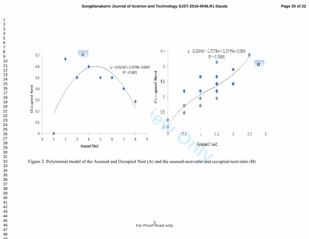
Relationships between the assessed and occupied nest of the WBSE gave a parabolic
model form (Figure 2A) and it can be expressed as;
0839.0298.00323.0 2−+−= xxy - - - (ii)
Where y was the number of nest occupied and y was the number of occupied nest.
The model statistics include 3.454 (F-statistics), 0.5801 (R2) and corrected Akaike
Information Criteria (AICC) of 495.129. However, the relationship between the ratio of
the assessed nest and ratio of the occupied nest (Figure 2B) produced a cubic relationship
and it is expressed thus;
064.05745.1778.0203.0 23−+−= xxxy - - - (iii)
Where y = yr and x = xr as defined in (i) earlier.
The model statistics returned significant F statistics of 37.092 and coefficient of
determination (R2) of 0.789. The AICC returned for this model was 482.87 and it was
lesser than AICC returned for (ii). The implication of this result is that model (iii) would
Page 6 of 22
For Proof Read only
Songklanakarin Journal of Science and Technology SJST-2016-0046.R1 Dauda
123456789101112131415161718192021222324252627282930313233343536373839404142434445464748495051525354555657585960

For Review O
nly
6
give a more parsimonious model than model (ii). Hence, the cubic model is therefore
chosen for predicting the frequency of nest occupation by WBSE.
The algorithm of nest site selection include, integration of relevant information into a GIS
database in an appropriate format like polygon, line, point, or grid layers and processing
same to produce new grid layer for each criterion (Figure 3). Similarly, all the WBSE
nests were found in tall emergent trees of the forest. They were fond of nesting in low
dipterocarp forests (0-300 meters) in the study area. This dipterocarp consist of mature
tree and regrowth with dense canopy cover. The nest site features based on this study can
be partitioned into; topographic and disturbance characteristics.
Topographic Characteristics of the nest sites
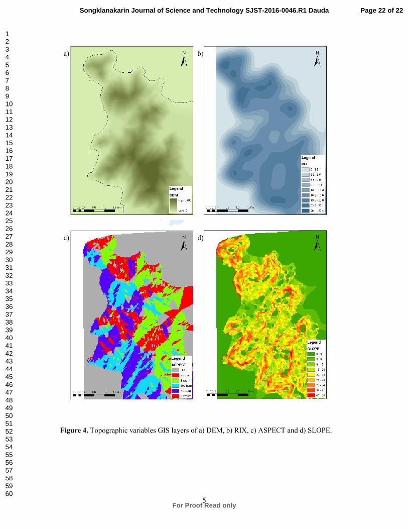
The digital elevation model (DEM) showed that the study area (Figure 4A) was
characterized by high elevation (4500) with pockets of low or zero elevation at the edges.
Higher percentages of these elevation clusters were obtained at the southern region of the
study area (Figure 4A). The mean elevation of the nest sites was generally 92m ± 6.3m
above sea level and it was significantly (P < 0.05) lower than the mean elevation (147 ±
9.7m) obtained for the entire Penang National Park (Table 3). Most nests (59%) were at
low altitude, below 100 meters above sea level. The nesting points ranged between the
elevation of 13m and 219m. WBSE were found to nest in steep areas with an up to 35.5°
slopes. The average slope of the nest sites (22.50 ± 7.0°) was significantly higher than the
general average slope of random points (18.6 ± 9.4°) in the entire Penang National Park.
This result was also significant (P < 0.05).
Page 7 of 22
For Proof Read only
Songklanakarin Journal of Science and Technology SJST-2016-0046.R1 Dauda
123456789101112131415161718192021222324252627282930313233343536373839404142434445464748495051525354555657585960

For Review O
nly
7
The ruggedness map showed that majority of the sections of the study area has RIX
greater than 6.5 – 9.8 (Figure 4B). RIX less than 6.5 were however patchily available in
the study area. In addition, the area supported few flat surfaces (Figure 4C) while other 4
regions (Northern, Eastern, Southern and Western) were sufficiently and randomly
distributed. Most of the nest sites were established against east-ward direction with a
bearing of 450-135
0. Nine percent (9%) of the nest sites were found on east-ward facing
the slopes while 36% were found on south-ward direction. Also, 29% were found on the
west–ward direction and 27% on the north-ward direction. The result of the contingency
analysis of the nest directions showed that there was no significant difference (χ2
3, 0.05 =
5.294) between the observed nests’ direction against the expected nests’ direction (P <
0.05).
Similarly, the slopes generally fall between 20 and 29 (Figure 4d) indicating moderate
steepness of the area. However, pockets of very steep and zero slopes were scattered
throughout the entire study area. The steepness of the nest sites using ruggedness index
based on the density of the contours revealed that most nest were located on steep sides
of cliffs overlooking water body. The contours density around nest sites was 18.2 ± 4.4
km/km² and it is not significantly different from the contour density (17.8 ± 3.7 km/km²)
of the entire study area (P > 0.05). The contour density around the WBSE nest could
therefore be said to be 0.225 more than the contour of the entire study sites
Disturbance characteristics
The average distance between nest sites and the nearest house or building was 920 ±
60.4m. This was also less than the average distance (1002m ± 46.2m) of random points to
Page 8 of 22
For Proof Read only
Songklanakarin Journal of Science and Technology SJST-2016-0046.R1 Dauda
123456789101112131415161718192021222324252627282930313233343536373839404142434445464748495051525354555657585960

For Review O
nly
8
the nearest house or building in the entire study area and this result was not significant (P
> 0.05 – Table 3). The average proximal nest was 2083m ± 66.1m and the minimum was
513m. This was however significantly less than the average nest distance (1557m ±
73.0m) to the nearest roads in the study area (P < 0.05 – Table 3). The average distance
to the nearest water body or large river for all nest sites was 219 ± 15.7m with a
minimum distance of 18m. The average general distance between random sites to the
nearest water (821.0m ± 63.8m) in Penang National Park area was significantly higher (P
< 0.01). The implication of this result was that nests location was nearer to water body in
comparison with the other facilities (buildings and roads) in the entire study area.
Discussions
Topography was found to be one of the most significant landscape property selected by
the WBSE in this nest-site selection study. Altitude was found to be a topographic index
that discriminate the nest sites from the entire habitat. The choice of low elevation to
build nest by the sea eagles may be hinged on the need to minimize the energy use in
reaching their nests when returning from foraging at sea level (Thurstans, 2009). WBSE’s
preference for lower altitude and larger tree is also attributable to protection against wind
speed and evaporation and it is in concord with Appanah and Turnbull (1998). Similarly,
the nesting against east ward of WBSE could be hinged on protection against solar
radiation. It had been established that south-wards nest (Brown and Mooney, 1997) gives
less solar radiation and evaporation thereby contributing to greater soil moisture as well
as support greater tree densities. Similarly, some of the nests were found on the sheltered
Page 9 of 22
For Proof Read only
Songklanakarin Journal of Science and Technology SJST-2016-0046.R1 Dauda
123456789101112131415161718192021222324252627282930313233343536373839404142434445464748495051525354555657585960
For Review O
nly
9
section probably to serve as shield against the prevailing weather. Harsh weather
condition is deleterious to the eggs and nestling (Janes, 1985).
The preference of the WBSE’s nesting on steep terrain of the cliff could be due to the
provision of dominant viewing position for catching prey. This conforms to Mathieu et
al. (2006) which established that steep terrain provides a dominant position with good
views of the surrounding landscape for observing prey. Steep terrain was also said to
provide better opportunities for nest defense as well as reduce the chances of encounter
with predators (Mathieu et al., 2006).
From this study, proximity to water was equally found to be the best discriminant
variable of the nest sites from the entire habitat. This is due to the fact that proximity to
water provides better access to food. The minimum distance to water body from nest sites
at this study area was far well below the previously recorded minimum distance of 1
kilometer (within 13 kilometers) in Victoria, Australia (Emison and Bilney, 1982). The
presence of most of the nests within 605m radius of the coast areas of forest on cliffs near
the shoreline also supported this assertion. WBSE did not tend to nest further away from
houses and buildings compared to from roads in the study area. Houses and buildings
were present throughout the study area with a variety of human activity while roads are
present only at the outskirt of the Penang National Park. The minimum distance of nests
to houses or building as obtained in this study was greater than 50m reported for
Kangaroo Island, Australia (Dennis et al., 2005). The presence of houses however was
found to constitute zero threat to the WBSE possibly due to lack of physical presence of
human being. This also suggests that provided other features are available, WBSE might
Page 10 of 22
For Proof Read only
Songklanakarin Journal of Science and Technology SJST-2016-0046.R1 Dauda
123456789101112131415161718192021222324252627282930313233343536373839404142434445464748495051525354555657585960

For Review O
nly
10
not necessarily or actively avoid human presence, especially when their (human)
population density is low.
The dense forest was attractive to the WBSE due to array of benefits derivable from it.
These include shade from the canopy cover and protection from wind thereby reducing
chill factor (Thurstans, 2009) as well as protection from direct sunlight (Reynold et al.,
1982). Although there existed stretch of mangrove habitat at southern part of the study
area where WBSE can be sighted, no nest was however found in the area. The nest-site
assessment in conclusion divulged several significant variables and well-defined ranges
(of parameters) that were not visible from simple observation of nests. The availability of
relatively high number of nest data and other spatial data, along with the tools to analyze
and manipulate data from several sources within GIS systems, were vital for such
assessment (Livingston et al., 1990).
Implication for Ecological and Biodiversity Conservation.
This nest-site study provides information on location and composition of WBSE nest of
the study area. Also, the occupation-model gives a parsimonious prediction of the WBSE
population in any area and this is vital for biodiversity conservation through population
monitoring and control. The algorithm for GIS study of the nest site study was been
constructed and it would be found useful for periodic update of WBSE nest information.
This study thus provides an objective basis for strategic conservation and management of
WBSE. It is therefore recommended that this study should be aggregated with similar
study from other areas and countries of the world to form a global WBSE nest
characteristics.
Page 11 of 22
For Proof Read only
Songklanakarin Journal of Science and Technology SJST-2016-0046.R1 Dauda
123456789101112131415161718192021222324252627282930313233343536373839404142434445464748495051525354555657585960
For Review O
nly
11
Acknowledgments.
The authors hereby appreciate the support provided by the School of Biological Sciences,
Universiti Sains Malaysia for the field work facilitation and the TWAS-USM
PostDoctoral Fellowship provided to Dauda T.O.
REFERENCES
Appanah, S. and Turnbull, J.M. 1998. A Review of Dipterocarps; Taxonomy, ecology and
silviculture. Bogor; Center for International Forestry Research 79pp.
Andrew, J.M. and Mosher, J.A. 1982. Bald Eagle Nest Site Selection and Nesting
Habitat in Maryland. The Journal of Wildlife Management, 46 (2), 382- 390.
Barri, F.R., Martella, M.B. and Navarro, J.L. 2009. Nest-site habitat selection by Lesser
Rheas (Rhea pennata pennata) in northwestern Patagonia, Argentina. Journal of
Ornithology. 150 (2), 511 – 514.
Bisson, I.A., Ferrer, M. and Bird, D.M. 2002. Factors influencing nest-site selection by
Spanish Imperial Eagles. Journal of Field Ornithology. 73(3), 298–302.
Brown, W. E. and Mooney, N. J. 1997. Modelling of the Nesting Habitat of the Wedge-
tailed Eagle (Aquila audax fleayi) in Tasmania. Report to the Tasmanian RFA
Environment and Heritage Technical Committee. Tasmanian Public Land Use
Commission, 65pp.
Chan, N.W., Ismail, W.R. and Ibrahim, A.L. 2003. The Geography, Climate and
Hydrology of Pantai Acheh Forest Reserve, Penang, Malaysia. In Pantai Acheh
Page 12 of 22
For Proof Read only
Songklanakarin Journal of Science and Technology SJST-2016-0046.R1 Dauda
123456789101112131415161718192021222324252627282930313233343536373839404142434445464748495051525354555657585960

For Review O
nly
12
Forest Reserve: The Case for a State Park. L. K. Chan, (Ed.). Penerbit Universiti
Sains Malaysia, Penang, 37pp.
Dauda, T.O., Shahrul A. M. S., Liyana K. and Wan Mohd, M. W. (2015). Range
Measurement and a Habitat Suitability Map for the Norway Rat in a Highly
Developed Urban Environment. Tropical Life Sciences Research, 26(2), 27–44.
Dennis, T. E., Kinloch, M. A., Pisanu, P. and King, C. 2011. The distribution and
breeding status of White-bellied Sea-Eagle and Osprey populations on Kangaroo
Island in 2005. Report to Kangaroo Island Natural Resources Management Board
and Department for Environment and Heritage, South Australia. Kingscote,
152pp.
Donazar, J. A., Hiraldo, F. and Bustamante, J. 1993. Factors influencing nest site
selection, breeding density and breeding success in the Bearded Vulture
(Gypaetus barbatus). Journal of Applied Ecology. 30, 504–514.
Edwards, T. C. Jr. and Collopy, M. W. 1988. Nest tree preference of Ospreys in
northcentral Florida. Journal of Wildlife Management. 52, 103–107.
Emison, W.B. and Bilney, R.J. 1982. Nesting habitat and nest characteristics of the
White-bellied Sea-Eagle in the Gippsland Lakes region of Victoria, Australia.
Raptor Research. 16(2), 54-58.
Fielding, A.H. and Haworth, P.F. 1995. Testing the generality of bird-habitat models.
Conservation Biology. 9, 1466-1481.
Hayward, G.D. and Escano, R.E. 1989. Goshawk nest-site characteristics in western
Montana and northern Idaho. The Condor. 91, 476-479.
Janes, S.W. 1985. Habitat selection in raptorial birds. In: Cody, M.L. (Ed.) Habitat
Selection in Birds. New York: Academic Press, 159-187.
Page 13 of 22
For Proof Read only
Songklanakarin Journal of Science and Technology SJST-2016-0046.R1 Dauda
123456789101112131415161718192021222324252627282930313233343536373839404142434445464748495051525354555657585960

For Review O
nly
13
Johansson, T. 2001. Habitat Selection, Nest Predation and Conservation Biology in a
Black-tailed Godwit (Limosa limosa) Population. PhD. Thesis of Uppsala
University, Sweden.
Jones, J. 2001. Habitat Selection Studies in Avian Ecology: A Critical Review. The Auk.
118, 556-562.
Karl, J.W., Heglund, P.J., Garton, E.O., Scott, J.M., Wright, N.M. and Lutto, R.L. 2000.
Sensitivity of species-habitat relationship model performance to factors of scale.
Ecological Applications. 10, 1690-1705.
Licoppe, A.M. 2006. The diurnal habitat used by red deer (Cervus elaphus L.) in the
Haute Ardenne. European Journal of Wildlife Research. 52, 164-170.
Livingston, S. A., Todd, C. S., Krohn, W. B. and Owen, R. B. Jr. 1990. Habitat models
for nesting Bald Eagles in Maine. Journal of Wildlife Management. 54, 644–
653.
Marks, J.S. 1986. Nest-site Characteristics and reproductive success of Long Eared Owls
in Southwestern Idaho. Wilson Bull. 98(4), 547-560.
Mathieu, R., Seddon, P. and Leiendecker, J. 2006. Predicting the Distribution of Raptors
Using Remote Sensing Techniques and Geographic Information Systems: A Case
Study with the Eastern New Zealand Falcon (Falco novaeseelandiae). New
Zealand Journal of Zoology. 33, 73-84.
Olivier, F. 2006. Nesting Habitat Preferences of Snow Petrels (Pagodroma nivea) and
Wilson’s Storm petrels (Oceanites oceanicus) in East Antarctica - A Modelling
Approach to Predict Species Distribution. PhD Thesis of University of Tasmania.
Page 14 of 22
For Proof Read only
Songklanakarin Journal of Science and Technology SJST-2016-0046.R1 Dauda
123456789101112131415161718192021222324252627282930313233343536373839404142434445464748495051525354555657585960

For Review O
nly
14
Reynolds, R. T., Meslow, E. C. and Wight, H. M. 1982. Nesting habitat of coexisting
Accipiter in Oregon. Journal of Wildlife Management. 46, 124–138.
Shiraki, S. 1994. Characteristics of White-tailed Sea Eagle nest sites in Hokkaido, Japan.
Condor. 96, 1003–1008.
Suarez, S., Balbontin, J. and Ferrer, M. 2000. Nesting habitat selection by Booted Eagles
Hieraaetus pennatus and implications for management. Journal of Applied
Ecology. 37, 215–223.
Tapia, L., Domínguez, J. and Rodríguez, L. 2007. Modelling habitat use and distribution
of golden eagles Aquila chrysaetos in a low-density area of the Iberian Peninsula.
Biodiversity Conservation. 16, 3559-3574.
Thurstans, S.D. 2009. A survey of White-bellied Sea-Eagle Haliaeetus leucogaster nests
in Tasmania in 2003. Corella. 33(3), 66-70.
Vierling, K.T. 1997. Habitat Selection of Lewis' Woodpeckers in Southeastern Colorado.
The Wilson Bulletin. 109(1), 121-130.
Vogiatzakis, I.N. 2003. GIS-based Modelling and Ecology: A Review of Tools and
Methods. Geographical Paper No. 170. Whiteknights; University of Reading
29pp.
Wiersma, J. M. and Richardson, A. 2009. Foraging of White-Bellied Sea-Eagles
Haliaeetus leucogaster In Relation To Marine Fish Farms In Tasmania. Corella.
33(3), 71-79.
Yusop, H. 2004. Laporan Bengkel Pelan Pengurusan Taman Negara Pulau Pinang.
PERHILITAN, Pulau Pinang, 27pp.
Page 15 of 22
For Proof Read only
Songklanakarin Journal of Science and Technology SJST-2016-0046.R1 Dauda
123456789101112131415161718192021222324252627282930313233343536373839404142434445464748495051525354555657585960

For Review O
nly
1
Table 1. Test of variance for Different Areas and Mean Separation for the Assessed and
Occupied Nest Parameters Option Assessed Nest Occupied Nest
F-statistics 10.18** 4.90**
Df 7 7
Teluk Bahang 0 0
Mean Separation Teluk Aling 21.00cd
14.00bc
Teluk Duyung 14.00ed
7.00cd
Muka Head 35.00bc
21.00ab
Teluk Ketapang 28.00cd
14.00bc
Pantai Kerachut 56.00a 28.00
a
Teluk Kampi 35.00bc
14.00bc
Pantai Mas 49.00ab
14.00bc
Table 2. Habitat variables used to characterize White-bellied Sea-Eagle nest-site selection.
Variables Description
Topographic variables Elevation Nest tree altitude above sea level
(a.s.l. - m)
Slope Slope gradient (°)
Aspect Slope azimuth (°)
Ruggedness index (RIX) Density of contours (km/km²)
Disturbance variables Distance to road Minimum distance from nest tree to
any roads (m)
Distance to building
Minimum distance from nest tree to
building (m)
Distance to water Distance from nest tree to nearest
water body (m)
Page 16 of 22
For Proof Read only
Songklanakarin Journal of Science and Technology SJST-2016-0046.R1 Dauda
123456789101112131415161718192021222324252627282930313233343536373839404142434445464748495051525354555657585960

For Review O
nly
2
Table 3. Summary of results from nest-site selection analysis tests on White-bellied
Sea-Eagle habitat parameters.
Parameter Nest sites (mean) Random sites (mean) Result
Elevation 92 ± 63 147 ± 97 t-test, P = 0.004*
Slope 22.5 ± 7.0 18.6 ± 9.4 t-test, P = 0.038*
Aspect
Southern (35.3%),
Tested against random
distribution (34 ÷ 4) χ² = 5.294, P = 0.151**
Western (29.4%),
Northern (26.5%),
Eastern (8.8%)
RIX 18.2 ± 4.4 17.8 ± 3.7 t-test, P = 0.654**
Distance to
building 920 ± 604 1002 ± 462 t-test, P = 0.461**
Distance to
road 2083 ± 661 1557 ± 730 t-test, P = 0.001*
Distance to
water 219 ± 157 821 ± 638 t-test, P = 0.0001*
Page 17 of 22
For Proof Read only
Songklanakarin Journal of Science and Technology SJST-2016-0046.R1 Dauda
123456789101112131415161718192021222324252627282930313233343536373839404142434445464748495051525354555657585960

For Review O
nly
1
LIST OF FIGURE TITLE
Figure 1. Location of Penang National Park on the Penang Island (A) and Random
points generated on the Penang National Park map using ArcGIS (B)
Figure 2. Polynomial model of the Assesed and Occupied Nest (A) and the assesed-
nest-ratio and occupied-nest-ratio (B)
Figure 3. Algorithm of nest-site selection analysis.
Figure 4. Topographic variables GIS layers of a) DEM, b) RIX, c) ASPECT and d) SLOPE.
Page 18 of 22
For Proof Read only
Songklanakarin Journal of Science and Technology SJST-2016-0046.R1 Dauda
123456789101112131415161718192021222324252627282930313233343536373839404142434445464748495051525354555657585960
For Review Only
2
Penang
National
Park
Peninsular
Malaysia
Penang
Island
Penang
Island
Figure 1. Location of Penang National Park on the Penang Island (A) and Random points generated on the Penang
National Park map using ArcGIS (B)
A B
Page 19 of 22
For Proof Read only
Songklanakarin Journal of Science and Technology SJST-2016-0046.R1 Dauda
123456789101112131415161718192021222324252627282930313233343536373839404142434445464748495051525354555657585960
For Review Only
3
Figure 2. Polynomial model of the Assesed and Occupied Nest (A) and the assesed-nest-ratio and occupied-nest-ratio (B)
A
B
Page 20 of 22
For Proof Read only
Songklanakarin Journal of Science and Technology SJST-2016-0046.R1 Dauda
123456789101112131415161718192021222324252627282930313233343536373839404142434445464748495051525354555657585960

For Review O
nly
4
Figure 3. Algorithm of nest-site selection analysis.
Selection of
Habitat
Features
DEM
Construction
Elevation RIX Aspect Slope
GIS
Database
Topographical
Map
Water, Road,
& Building
Data
Nest-site Selection
Analysis
White-bellied Sea Eagles
Habitat Preferences
Field
Survey
Nest Data
t-test &
Chi-square test
Selected
Habitat
(34 nest sites)
Available Habitat
(60 random points)
comparism
Page 21 of 22
For Proof Read only
Songklanakarin Journal of Science and Technology SJST-2016-0046.R1 Dauda
123456789101112131415161718192021222324252627282930313233343536373839404142434445464748495051525354555657585960
For Review O
nly
5
Figure 4. Topographic variables GIS layers of a) DEM, b) RIX, c) ASPECT and d) SLOPE.
a)
c)
b)
d)
Page 22 of 22
For Proof Read only
Songklanakarin Journal of Science and Technology SJST-2016-0046.R1 Dauda
123456789101112131415161718192021222324252627282930313233343536373839404142434445464748495051525354555657585960