for personal use only figure 1: location of the mcarthur river project… · 2013-09-15 ·...
TRANSCRIPT

ASX
16th September
ASX CODE:
REGISTERED TNG Level 1, 282 Rokeby Subiaco, Western Australia
T +61 8 9327 F +61 8 9327
W E
ABN 12 000 817
Jianrong Paul Michael Stuart Rex Wang
COMPANY Simon
Mount Peake: Manbarrum: East Rover: McArthur: Mount Hardy Sandover
CONTACT
Paul Burton | +61 8 9327 Nicholas Read | +61 419 929 Simon Robertson | +61 8 9327
EXTENSIVE COPPER-LEAD-ZINC TARGETS IDENTIFIED AT TNG’s McARTHUR RIVER PROJECT, NT
Central geochemical anomaly over 3km long and up to 450m wide
with coincident IP anomalies Highlights: • Three large geochemical anomalous zones with geophysical
anomalies outlined from a review of historical data at McArthur River Project, 60km south of the world-class McArthur River Zinc Mine (Xstrata).
• A central continuous geochemical zone 3,000m long and up
to 450m wide with anomalous analytical values up to 1,400ppm Zn and 670ppm Pb from soil samples.
• Two other extensive zones of Zn-Pb-Cu anomalism with soil
sample results to 1,150ppm Cu and 800ppm Zn. • In addition geophysical IP anomalies identified which are
coincident with the geochemical anomalies and structural targets.
• An adjoining tenement acquired increasing the Company’s
tenure to 223km2 now including 17 strike kilometres of highly prospective stratigraphy.
• New tenement is located adjacent to TNG’s existing EL 27711
in the highly prospective Batten Trough and south of the Xstrata mine.
• Field program to commence shortly to refine target areas. Australian resources company TNG Limited (ASX: TNG) is pleased to report that it has identified a large, extensive and strong geochemical zone with coincident geophysical targets following a review of historical exploration data from its McArthur River Project in the Northern Territory, located 60km south of the world-class McArthur River Zinc Mine. The targets include a very large central continuous geochemical anomaly extending over a strike length of 3km and up to 450m wide containing laboratory analytical values of up to 1,400ppm Zn and 670ppm Pb from soil samples plus two other zones of strong surface geochemical anomalism, with existing coincident strong geophysical targets from Induced Polarisation (IP) surveys. TNG has applied for additional tenure as a result, adjacent to the existing McArthur River tenements to secure its strategic position along this prospective trend (Figure 1), increasing its total land-holding in the region to 223km2.
For
per
sona
l use
onl
y
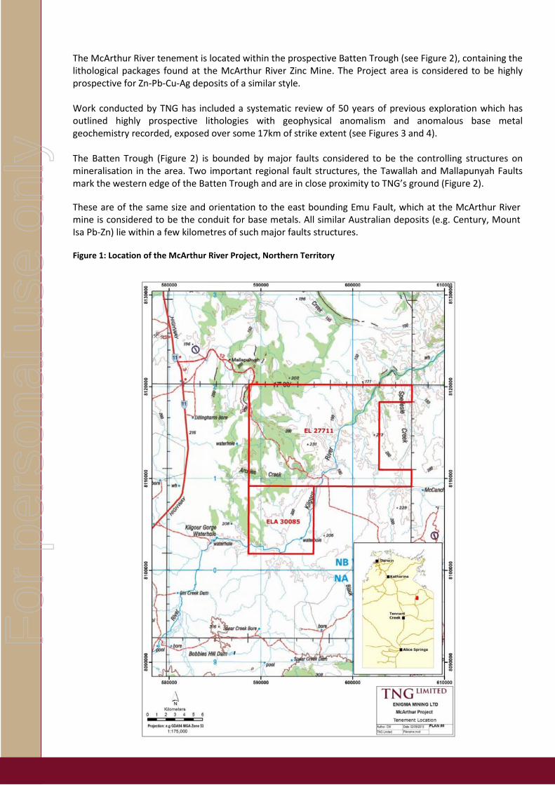
The McArthur River tenement is located within the prospective Batten Trough (see Figure 2), containing the lithological packages found at the McArthur River Zinc Mine. The Project area is considered to be highly prospective for Zn-Pb-Cu-Ag deposits of a similar style. Work conducted by TNG has included a systematic review of 50 years of previous exploration which has outlined highly prospective lithologies with geophysical anomalism and anomalous base metal geochemistry recorded, exposed over some 17km of strike extent (see Figures 3 and 4). The Batten Trough (Figure 2) is bounded by major faults considered to be the controlling structures on mineralisation in the area. Two important regional fault structures, the Tawallah and Mallapunyah Faults mark the western edge of the Batten Trough and are in close proximity to TNG’s ground (Figure 2).
These are of the same size and orientation to the east bounding Emu Fault, which at the McArthur River mine is considered to be the conduit for base metals. All similar Australian deposits (e.g. Century, Mount Isa Pb-Zn) lie within a few kilometres of such major faults structures. Figure 1: Location of the McArthur River Project, Northern Territory
For
per
sona
l use
onl
y

Figure 2: Location of the McArthur River Project in relation other deposits in the district and regional structures.
TNG’s collated information revealed a large semi-continuous zone of highly anomalous zinc-lead-copper results close to the western fault structures.
Figure 3 shows the areas with anomalous soil geochemistry delineated by TNG’s work from extensive sampling conducted by Australian Geophysical Pty Ltd. (AGPL) in 1967. Three large coincident multi-element anomalous areas have been identified:
1. A central zinc zone (straddling the tenements)
o 3000m long and up to 450m wide,
o with results up to 1400ppm Zn that has
o coincident Pb (to 670ppm), and
o partially coincident Cu with
o IP anomalies.
For
per
sona
l use
onl
y

2. A north-eastern zinc-copper zone
o 800m long
o zinc results up to 600ppm,
o Copper results up to 1000ppm and lead to 520ppm
o coincident (down dip) IP geophysical anomaly
3. A south-west zinc-copper zone
o 1200m long
o Results up to 800ppm Zn and
o 1150ppm Cu.
AGPL also carried out extensive Induced Polarisation (IP) geophysical surveys based on the soil geochemical results. These have been reviewed and confirmed by TNG’s external consulting geophysicist. Figure 4 shows the prospective stratigraphy together with the areas of geophysical anomalism.
Areas with low resistivity and moderate to high chargeability are highlighted. These are coincident with the strongest geochemical anomalies shown in Figure 3 and are likely to represent sulphides and or base metal mineralisation within the central/upper prospective Woologorang rock Formation.
This large area of strongly anomalous geochemistry, together with IP anomalism in a favourable structural setting, may indicate the presence of significant mineralisation within the tenement package. AGPL did not follow up with any drilling for unknown reasons.
TNG is planning a limited field programme to check the anomalous area and targets.
TNG’s Managing Director, Mr Paul Burton, said: “The internal review work we have completed in recent months has revealed a hidden exciting opportunity within historic data from a highly prospective and under-explored area, adding value to our McArthur River Project. It ticks a lot of boxes given the geological location and proximity to structures that run through it, and the strong coincident geophysical and geochemical results we have identified.
“We will continue to conduct strategic reviews of this nature to add value to our exploration tenure followed by low-cost reconnaissance exploration activity before considering the best way to move the project to the next stage. This includes our existing reviews of the extensive position we hold in the emerging prospective Arunta region where our Mt Hardy, Sandover and Wallabanba Projects are located.
“Our focus remains on completing the current Feasibility Study on the Mount Peake strategic metals project,” he added. “However, increasing value for shareholders by low cost reviews of our extensive tenement position in the Northern Territory also remains an important strategic focus for the company.”
TNG LIMITED Paul E Burton Managing Director 6 February 2013
For
per
sona
l use
onl
y

Figure 3: Location of prospective stratigraphy and geochemical anomalies in the central McArthur River Project area
For
per
sona
l use
onl
y
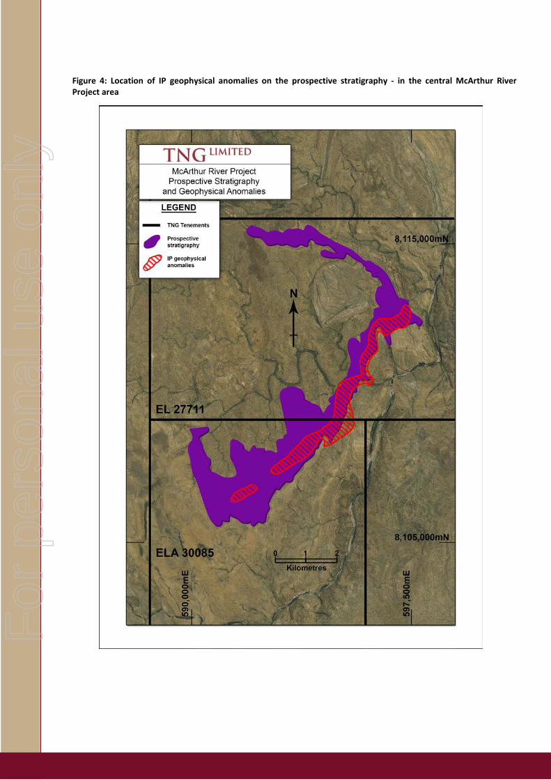
Figure 4: Location of IP geophysical anomalies on the prospective stratigraphy - in the central McArthur River Project area
For
per
sona
l use
onl
y

Enquiries: Paul E Burton,
Managing Director + 61 (0) 8 9327 0900 Nicholas Read Read Corporate + 61 (0) 8 9388 1474
Competent Person Statement
The information in this report that relates to Exploration Results and Exploration Targets is based on, and fairly represents, information and supporting documentation compiled by Exploration Manager Mr Kim Grey B.Sc. and M. Econ. Geol. Mr Grey is a member of the Australian Institute of Geoscientists, and a full time employee of TNG Limited. Mr Grey has sufficient experience relevant to the style of mineralisation and type of deposit under consideration and to the activity which he is undertaking to qualify as a Competent Person as defined in the 2012 Edition of the ‘Australasian Code for Reporting of Exploration Results, Mineral Resources and Ore Reserves’. Mr Grey consents to the inclusion in the report of the matters based on his information in the form and context in which it appear.
Exploration results reported here combine of recent TNG work (which has been conducted to industry-standard practice) and work by previous explorer AGPL in the 1960’s. This older work was done to a high standard for the day and is considered to be of good quality. TNG sampling was analysed by ALS laboratories and samples received total prep (100% of sample to >85% <75 um) with four acid digest and ICP/OES finish for a suite of 33 elements, including Cu, Zn, Pb, Ag. AGPL -80 mesh soil sampling was analysed by AAS technique for Cu, Zn, Pb, Ni, and Co.
Forward-Looking Statements This announcement has been prepared by TNG Ltd. This announcement is in summary form and does not purport to be all inclusive or complete. Recipients should conduct their own investigations and perform their own analysis in order to satisfy themselves as to the accuracy and completeness of the information, statements and opinions contained. This is for information purposes only. Neither this nor the information contained in it constitutes an offer, invitation, solicitation or recommendation in relation to the purchase or sale of TNG Ltd shares in any jurisdiction. This does not constitute investment advice and has been prepared without taking into account the recipient's investment objectives, financial circumstances or particular needs and the opinions and recommendations in this presentation are not intended to represent recommendations of particular investments to particular persons. Recipients should seek professional advice when deciding if an investment is appropriate. All securities transactions involve risks, which include (among others) the risk of adverse or unanticipated market, financial or political developments. To the fullest extent permitted by law, TNG Ltd, its officers, employees, agents and advisers do not make any representation or warranty, express or implied, as to the currency, accuracy, reliability or completeness of any information, statements, opinions, estimates, forecasts or other representations contained in this announcement. No responsibility for any errors or omissions from this arising out of negligence or otherwise is accepted. This may include forward looking statements. Forward looking statements are only predictions and are subject to risks, uncertainties and assumptions which are outside the control of TNG Ltd. Actual values, results or events may be materially different to those expressed or implied. About TNG: TNG Ltd is a junior exploration company with a focus on exploration and development of projects in the Northern Territory of Australia. The company is currently developing its 100% owned world class Mount Peake Vanadium –Titanium – Iron project in the which is currently in the Definitive Feasibility Stage, with anticipated production in 2015. In addition it is also actively exploring its copper projects including its 100% owned Mt Hardy project which is emerging as a potential major Copper/Gold and polymetalic project. The company has joint ventures on its other projects with Rio Tinto, Norilsk, and Western Desert Resources and strategic investment from Ao-Zhong Ltd., a 100% owned subsidiary of China’s ECE Ltd. For more information please see the company’s website at www.tngltd.com.au
For
per
sona
l use
onl
y

The following section is provided to ensure compliance with the JORC 2012 requirements for the reporting of Exploration Results.
Section 1 Sampling Techniques and Data Criteria JORC Code explanation Commentary
Sampling techniques
• Nature and quality of sampling (eg cut channels, random chips, or specific specialised industry standard measurement tools appropriate to the minerals under investigation, such as down hole gamma sondes, or handheld XRF instruments, etc). These examples should not be taken as limiting the broad meaning of sampling.
• Include reference to measures taken to ensure sample representivity and the appropriate calibration of any measurement tools or systems used.
• Aspects of the determination of mineralisation that are Material to the Public Report.
• In cases where ‘industry standard’ work has been done this would be relatively simple (eg ‘reverse circulation drilling was used to obtain 1 m samples from which 3 kg was pulverised to produce a 30 g charge for fire assay’). In other cases more explanation may be required, such as where there is coarse gold that has inherent sampling problems. Unusual commodities or mineralisation types (eg submarine nodules) may warrant disclosure of detailed information.
• Existing work reported here consists of geological mapping and soil and rock chip sampling by TNG and previous explorers. Discussion of work by TNG is provided in bold font and that by previous companies (essentially AGPL in 1967) in normal font.
• TNG sampling consists of rock chip samples taken in 2011 with a 1-4 kilogram sample delivered to the laboratory
• Reported previous work by AGPL was soil sampling utilizing -80 mesh sieving to provide an industry standard 100-300gram fine fraction sample to the laboratory
• Limited details are now available on the QA/QC undertaken by AGPL
Drilling techniques
• Drill type (eg core, reverse circulation, open-hole hammer, rotary air blast, auger, Bangka, sonic, etc) and details (eg core diameter, triple or standard tube, depth of diamond tails, face-sampling bit or other type, whether core is oriented and if so, by what method, etc).
• Not relevant
Drill sample recovery
• Method of recording and assessing core and chip sample recoveries and results assessed.
• Measures taken to maximise sample recovery and ensure representative nature of the samples.
• Whether a relationship exists between sample recovery and grade and whether sample bias may have occurred due to preferential loss/gain of fine/coarse material.
• Not relevant
Logging • Whether core and chip samples have been geologically and geotechnically logged to a level of detail to support appropriate Mineral Resource estimation, mining studies and metallurgical studies.
• Whether logging is qualitative or quantitative in nature. Core (or costean, channel, etc) photography.
• The total length and percentage of the relevant intersections logged.
• Not relevant
For
per
sona
l use
onl
y

Criteria JORC Code explanation Commentary
Sub-sampling techniques and sample preparation
• If core, whether cut or sawn and whether quarter, half or all core taken. • If non-core, whether riffled, tube sampled, rotary split, etc and whether
sampled wet or dry. • For all sample types, the nature, quality and appropriateness of the
sample preparation technique. • Quality control procedures adopted for all sub-sampling stages to
maximise representivity of samples. • Measures taken to ensure that the sampling is representative of the in
situ material collected, including for instance results for field duplicate/second-half sampling.
• Whether sample sizes are appropriate to the grain size of the material being sampled.
• Soil and rock sampling utilized industry standard sub-sampling techniques and is considered of good quality
• TNG rock samples were oven dried, coarse crushed, and fully pulverised to >85% <75 micron
• Certified Standards were inserted into the TNG sampling batches (1 in 20) and results considered adequate
• AGPL -80 mesh soil samples did not require coarse crushing • QC regime for the AGPL sampling is not known • Sample sizes are considered to be adequate to represent
the material sampled and the style of mineralisation expected
Quality of assay data and laboratory tests
• The nature, quality and appropriateness of the assaying and laboratory procedures used and whether the technique is considered partial or total.
• For geophysical tools, spectrometers, handheld XRF instruments, etc, the parameters used in determining the analysis including instrument make and model, reading times, calibrations factors applied and their derivation, etc.
• Nature of quality control procedures adopted (eg standards, blanks, duplicates, external laboratory checks) and whether acceptable levels of accuracy (ie lack of bias) and precision have been established.
• TNG pulverized rock samples had a four acid digest (near total) and were analysed by ICP technique (ICP/OES and ICP/MS) for a 33 element suite of elements including Cu, Zn, Pb
• AGPL soil samples were anaysed by AAS for Cu, Zn, Pb, Co, and Ni only with results reported only on plans plotting values above 50ppm for Pb and above 100ppm for Cu and Zn only.
• Both sets of laboratory data are considered to be adequate for defining the geochemical anomalism shown on Figure 3
Verification of sampling and assaying
• The verification of significant intersections by either independent or alternative company personnel.
• The use of twinned holes. • Documentation of primary data, data entry procedures, data
verification, data storage (physical and electronic) protocols. • Discuss any adjustment to assay data.
• Results reported here have been scrutinized by both TNG’s project exploration geologist and Exploration Manager
• Data has been recorded into Excel spreadsheet with visual/plotting validation performed
Location of data points
• Accuracy and quality of surveys used to locate drill holes (collar and down-hole surveys), trenches, mine workings and other locations used in Mineral Resource estimation.
• Specification of the grid system used. • Quality and adequacy of topographic control.
• TNG sampling located by GPS to around 3m accuracy • AGPL data from open file reporting located by georeferencing
plans in GIS package (MapInfo) – likely better than 50 metres absolute accuracy
Data spacing and distribution
• Data spacing for reporting of Exploration Results. • Whether the data spacing and distribution is sufficient to establish the
degree of geological and grade continuity appropriate for the Mineral Resource and Ore Reserve estimation procedure(s) and classifications applied.
• Whether sample compositing has been applied.
• Original AGPL soil samples were collected on a 120 foot by 500 foot grid (ca. 31m x 150m). Some additional infill lines reduced this spacing over anomalous areas
• No compositing has been applied
For
per
sona
l use
onl
y

Criteria JORC Code explanation Commentary
Orientation of data in relation to geological structure
• Whether the orientation of sampling achieves unbiased sampling of possible structures and the extent to which this is known, considering the deposit type.
• If the relationship between the drilling orientation and the orientation of key mineralised structures is considered to have introduced a sampling bias, this should be assessed and reported if material.
• Sample orientation is appropriate for this type of mineralisation, with closer spaced sampling across the strike
Sample security
• The measures taken to ensure sample security. • Chain of custody was managed by TNG. Samples were delivered to the laboratory by TNG staff.
Audits or reviews
• The results of any audits or reviews of sampling techniques and data. • Due to the early stage of prospect evaluation at McArthur River there has been no audit of the sampling protocols to date. TNG follows its own industry-standard procedures
• It is not known what review was undertaken by AGPL
Criteria JORC Code explanation Commentary
Mineral tenement and land tenure status
• Type, reference name/number, location and ownership including agreements or material issues with third parties such as joint ventures, partnerships, overriding royalties, native title interests, historical sites, wilderness or national park and environmental settings.
• The security of the tenure held at the time of reporting along with any known impediments to obtaining a licence to operate in the area.
• EL 27711 is held 100% by Enigma Mining Limited, a wholy owned subsidiary of TNG Limited.
• ELA 30085 was pegged by Enigma Mining Limited, a wholy owned subsidiary of TNG Limited.
Exploration done by other parties
• Acknowledgment and appraisal of exploration by other parties. • Some of the commentary on the work completed on the McArthur River project refers to work by Australian Geophysical Pty Ltd in the late 1960’s, and can be found on the NTGS Open File system @ CR19670090
Geology • Deposit type, geological setting and style of mineralisation. • The tenement package is being explored for deposits similar to that mined at McArthur River 60km to the north. These Zn-Pb-Ag dominated systems are variably referred to as Sedex, or Stratiform Sediment-Hosted Zn-Pb-Ag Deposits, with well know examples being Mount Isa Pb-Zn and Century in Queensland
• Sedex deposits are found in Proterozoic marginal marine sedimentary basins of northern Australia
Section 2 Reporting of Exploration Results
For
per
sona
l use
onl
y

Criteria JORC Code explanation Commentary
Drill hole Information
• A summary of all information material to the understanding of the exploration results including a tabulation of the following information for all Material drill holes: o easting and northing of the drill hole collar o elevation or RL (Reduced Level – elevation above sea level in
metres) of the drill hole collar o dip and azimuth of the hole o down hole length and interception depth o hole length.
• If the exclusion of this information is justified on the basis that the information is not Material and this exclusion does not detract from the understanding of the report, the Competent Person should clearly explain why this is the case.
• Not relevant
Data aggregation methods
• In reporting Exploration Results, weighting averaging techniques, maximum and/or minimum grade truncations (eg cutting of high grades) and cut-off grades are usually Material and should be stated.
• Where aggregate intercepts incorporate short lengths of high grade results and longer lengths of low grade results, the procedure used for such aggregation should be stated and some typical examples of such aggregations should be shown in detail.
• The assumptions used for any reporting of metal equivalent values should be clearly stated.
• No averaging, weighting or metal equivalent calculations have been used
• Figure 3 shows areas with geochemical anomalism above the following cut off values
Zn 250ppm Cu 250ppm Pb 100ppm • These cut off values represent significant anomalism and
are 2-4 times background • Due to the scale of data presentation single samples within
the anomalous outline with below the cut off values have been included
Relationship between mineralisation widths and intercept lengths
• These relationships are particularly important in the reporting of Exploration Results.
• If the geometry of the mineralisation with respect to the drill hole angle is known, its nature should be reported.
• If it is not known and only the down hole lengths are reported, there should be a clear statement to this effect (eg ‘down hole length, true width not known’).
• The stratigraphy dips at a shallow angle (10-40 degrees) away from the centre of the Mallapunyah Dome
Diagrams • Appropriate maps and sections (with scales) and tabulations of intercepts should be included for any significant discovery being reported These should include, but not be limited to a plan view of drill hole collar locations and appropriate sectional views.
• See Announcement Figures
Balanced reporting
• Where comprehensive reporting of all Exploration Results is not practicable, representative reporting of both low and high grades and/or widths should be practiced to avoid misleading reporting of Exploration Results.
• All areas of the prospective stratigraphy have been soil sampled (see Figure 3). All geochemical anomalies are closed off, with background values for Cu, Zn, and Pb being less than 50ppm.
For
per
sona
l use
onl
y

Criteria JORC Code explanation Commentary
Other substantive exploration data
• Other exploration data, if meaningful and material, should be reported including (but not limited to): geological observations; geophysical survey results; geochemical survey results; bulk samples – size and method of treatment; metallurgical test results; bulk density, groundwater, geotechnical and rock characteristics; potential deleterious or contaminating substances.
• Individual IP geophysical traverses have results summarized in Figure 4
• Existing detailed geological mapping is represented by the “prospective stratigraphy” unit in Figure 3 and 4 .
• More detailed reporting need await further detailed prospect work
Further work • The nature and scale of planned further work (eg tests for lateral extensions or depth extensions or large-scale step-out drilling).
• Diagrams clearly highlighting the areas of possible extensions, including the main geological interpretations and future drilling areas, provided this information is not commercially sensitive.
• Work by previous exploration companies to be confirmed with TNG field sampling duplicating/confirming locations and tenor/grade of anomalism
• Confirmatory geological mapping including determining the mineralisation styles present is planned for 2013
• Follow up geophysical work planned for 2014
For
per
sona
l use
onl
y