foghive paper
DESCRIPTION
fog collection, water irrigation, desertTRANSCRIPT

made
at wsa31
Dr. Cristian Suau
FogHive©: Fog Collection and Sustainable Architecture in the Atacama Coast
It seems imperative to integrate renewable energy and climatic design in zero-carbon buildings in arid lands by employing natural and social science-based innovations applied in natural or built environs. The aim of this initial study is twofold: on one hand, to establish general climatic design codes for potential fog collection in different scales and, on another hand, to augment the rate and yield of fog collection used for irrigation and also drinking water in natural and urban areas.
The purpose is to incorporate zero-carbon design in sustainable landscape and architectural design and thus envision potential inhabitation through autonomous space-frame configurations along the coast of Tarapacá Region in Chile. In a sequential way, this study distinguishes three scales of interventions: territorial, local and domestic.
This research integrates climatic, structural and constructional factors by employing agile space-frame fogtraps;
implementing appropriate low-passive energy technologies; and combining hydrophobic and shading fabrics. The design upgrades the following aspects:
1. Increasing rate and yield of advection fog by taking into account harvesting rate and climatic parameters
2. Structural reinforcement of fog collectors through lightweight, modular and deployable polygonal space-frames
3. Reducing installation and maintenance of fog collection (material research)
4. Purification of drinking water due to concentrations of pollutants
5. Lowering frame impacts on ground and surrounding mainly in lomas
The survey methods consist of a literature review; fieldwork; a comparative analysis of existing fog collection’s techniques; and climatic design simulations.
The Coast Of Atacama Desert: A Hydro-Eolic Lab
It is well-known that the phenomenon of desertification is caused by both climate change and the actions of man (United Nations Environment Programme). In the case of Chile, the land degradation of arid, semi-arid and dry sub-humid areas is the result of two main variables: El Niño’s climatic performance and massive mining activities along the Andes Range, which require large amounts of surface and subterranean water resources for extracting, processing and transporting minerals.
Parts of Atacama Desert have not reported a drop of rain since recordkeeping began. Somehow, more than a million people squeeze life from this parched land.
Stretching 1000 kilometres from Peru’s southern border into northern Chile, the Atacama Desert rises from a thin coastal shelf to the ‘pampas’1. There are sterile, intimidating stretches where
(left) Sunset in the Atacama Desert and its ‘Camanchaca’ phenomenon in Alto Patache, Chile.(above) Map of coastal fog oases in the Region of Tarapaca, Chile: Alto Patache and Cerro Guanaco (nearby Alto Hospicio, Iquique). Source: Suau, 2010.

made
at wsa
mad
e
at wsa 32 33
in the landscape, urban and domestic scale. This initial study is determined as much by climatic and geographic factors as by any alternative for appropriate technologies. The main aim is stopping desertification by repairing endangered fog oases ecosystems, and harvesting water for drinking and irrigation and fostering potential inhabitation in self-sufficient polyhedral configurations along the coast of the Tarapacá Region, Chile. Due to intermittent winds, we also can obtain regular wind-based electricity.
Decades of pioneer applied research developed by University del Norte (1957) and recently continued by the Centro del Desierto de Atacama (CDA) have demonstrated that some of the most influential responses to these scarcities have been mounted at the level of fog oasis, farming fields, local villages and impoverished neighbourhoods.
The initial research stage (2010) has critically revised the studies made by the hydrologist Christiaan Gischler2 and three-dimensional fogtrap prototypes (so called macro-diamonds) developed by Carlos Espinosa and Ricardo Zuleta in Camanchaca laboratory. Based on these precedents, this survey updated and collected climatic and geographic data provided by CDA combining meeting
with experts and fieldwork in two fog oases: Alto Patache and Cerro Guanaco. Both are unique natural environments, although the latter is close to an urban settlement and is more vulnerable.
The final stage was to elaborate standard design codes for 3D fog catchers and integrate the principles of polyvalence in each design. To achieve the fog collectors’ shape, frame and components, I took into account three main climatic factors: wind (direction and speed), humidity and temperature. Parametric design was used to test various solutions of water collection in different scales, from landscape to domestic.
A Glance On Conventional Two-Dimensional Fogtraps
The more fog, the more wind. Fog catchers are structurally fragile devices. Nets tear, pipes leak, and wind can blow the whole structure over. Metal frames and tensors normally corrode, and birds attack nets, ruining the process of fog trapping. The conventional fog collectors3 utilised in Chile are two-dimensional tensile devices waving delicately on the tops of coastal arid cliffs. These structures use long and light nets mostly made with polypropylene; glistening with moisture, they transform
fog into precious water for reforestation, cultivation fields or small communities on the slopes below. Fog collection deals with horizontal precipitation. It actually imitates the missing link of trees. Once trees grow, they serve as natural fog catchers. A forest in a waterless area can trap and drip as much water into the dry soil as any idyllic rainfall.
These nets stand perpendicular to the prevailing wind, which blows fog into the woven plastic mesh. From there, droplets group and then fall into gutters that carry the water to collection tanks. The collector itself is completely passive, and the water is conveyed to the storage system by gravity. If topographic conditions are favourable, the stored water can also be conveyed by gravity to the point of use. The storage and distribution system usually consists of a plastic channel or PVC pipe approximately 110 mm in diameter which can be connected water hose for conveyance to the storage site/point of use. Storage is usually in a closed cistern. Chlorination of storage tanks may be necessary if the water is used for drinking purposes. Nevertheless there are some technical aspects that need to be upgraded:
The current technology represents a significant risk investment unless a pilot
rain has never been measured. Without moisture, nothing rots. Everything turns into perpetual vastness.
Settlements are established into coastal cities, mining complexes, fishing villages, and oasis towns. Along much of the coast of northern Chile, rainfall is so scarce that remote communities have long had to import water by trucks, a quite expensive and inefficient supply process, in order to survive. In the Atacama’s coastline, a dense fog known as ‘Camanchaca’ is abundant. Despite its aridity, the Atacama Desert hosts an impressive variety of plant life. The fog feeds flora called ‘ lomas’, isolated islands of vegetation that can contain a wide variety of species, from cactuses to ferns.
According to environmentalist and activist groups, about 34% of the Atacama’s total land surface is affected by this dehydration process. With no rainfall, the depletion and pollution of freshwater sources, and the existing pressures of urban population densities in the port cities, the current administration seems in weak in the attempt to mitigate and trim down the precious water exploitation caused by the mining sector.
Demographic data shows how rural settlements are shrinking, or simply depopulating and immigrating to port cities such as Antofagasta or Iquique. It is urgent to develop a map that shows how this territory is at risk by exposing current water resources and the shrinkage of rural
settlements and degradation of fertile hectares used for agriculture.
Water scarcity intrudes just as harmfully on communities less accustomed to managing with freshwater shortages, from the high valleys of the mountains to coastal hillside of slums. As a result, this fragile ecological linkage is experiencing the loss of regional biodiversity.
Research By Design
We have to find new ways to tackle climate into sustainable living by providing a more effective and holistic management of renewable energies like solar, wind and water supplies, particularly when it is reinforced by science-based innovations
Options of three-dimensional fog collector’s arrays in the fog oasis of Alto Patache. Option A: attached; option B: detached; and option C: stacked. Source: Suau.
The hexagonal footprint seems the most efficient way to response climatically to shading and fog water capture aspects. It secures the best length/height ratio for 3D fog collectors, which is 1:1 or 1:2 (proportional dimensions). Source: Suau.
The coldest months are from June to September. The highest frequency of fog is during September.
The mean month relative humidity is constantly high at over 80%. The highest mean value is 86%.
From 700m to 850m altitudes showed the best fog water collection potential. From 650m down slope, fog water collection is negligible during all months of the year.
Wind almost always blows from the South. Wind speeds at 1400 are 5.6 m/s. In winter months at 0800 AM windless or light breezes frequently prevail from the East and Northeast.
atacama coastal desert - chileaxo-sectionoptions of fog-catchers
pacific ocean
plain
SUAU©
windS-SW

made
at wsa
mad
e
at wsa 34 35
project is first carried out to quantify the potential rate and yield that can be anticipated from the fog harvesting rate and the periodicity of the fog within the area.
Community participation in the process of developing and operating these technologies to reduce installation, operating and maintenance costs.
If the harvesting area is not close to the points of use, the installation of the pipeline needed can be very pricey, especially in abrupt areas.
The technology is very sensitive to changes in climatic conditions, which could affect the water content and frequency of occurrence of
fogs. A backup water supply to be employed during low-harvest periods is recommended.
In Chile, fog water has failed to meet drinking water quality standards because of concentrations of chlorine, nitrate, and some minerals derived from mining sector. It is mostly used for horticulture and forestry.
Design Factors For Fogtraps In The Atacama Desert
It is well-known that the occurrence of fogs can be assessed from reports compiled by climatic stations (i.e.: airports, research units, etc). To be successful, this
technology should be located in areas where favourable climatic conditions exist such as the fog oases along the Atacama coast. Since fogs are carried to the harvesting site by intermittent winds, the topographic shape and orientation towards prevailing winds, solar position and wind speeds/directions will be prominent in determining the success of fog collectors. In order to increase the yield and harvesting of water collection, we have to augment the size and material properties of nets (colours, patterns, filaments types and hydrophobic features). The study highlights several factors that should be considered in selecting an appropriate site for fog harvesting in Atacama coast:
Plans and axonometric models of FogHive© - model 4. Source: Suau.
Climatic parameters, fog water collection and yield applied in 4 FogHive© models. Source: Suau.
Across section of FogHive©. Source: Suau.
FOGHIVE©: stationary polyhedral fog collector

made
at wsa
mad
e
at wsa 36 37
Wind speed and velocityThe high-pressure area in the eastern part of the South Pacific Ocean produces onshore, southwest winds in northern Chile for most of the year. Prevailing/secondary winds (S-SW) are ideal for advent fog collection. Wind almost always blows from the South. Wind speeds at 14.00pm rise to 5.6 m/s. In winter months at 08.00am, conditions are windless or with light breezes, below 2m/s in April.
Air temperature and fog water contentThe higher the formation, the lower the air temperature. In the coast of Tarapacá Region, the cooler months are from May to October. Hot seasons are from November to March4. For instance, in Alto Patache the high average temperature reaches 18C and the low temperature reaches roses 9.9C; the daily temperature lap is 7.7 C. The highest frequency of fog condensation occurs during September. There is a relationship between temperature and fog collecting: the cooler the mesh surface, the more water is collected.
Relative humidityThe higher is the formation the high is the relative humidity. The mean month relative humidity is constantly high at over 80%. The highest mean value is 86% in hot season (July).
TopographyIt is necessary to have sufficient topographic relief to intercept the fogs/clouds; in terms of continental scale, it includes the coastal cliffs of Atacama Desert, and, in a local scale, isolated high obstacles or coastal lomas.
Relief in the surrounding areasIt is imperative that there are no major blockages to the wind within a few kilometres upwind of the site (i.e.: Alto Patache and Cerro Guanaco). In arid coastal regions, the presence of an inland depression or basin that heats up during the day can be advantageous, as the localized low pressure area thus created can enhance the sea breeze and increase the wind speed at which marine cloud decks flow over the collection devices.
AltitudeThe breadth of the stratocumulus clouds and the height of their bases vary with location. As a rule of thumb, a desirable altitude is at two-thirds of the cloud thickness above the base. This portion of the cloud will normally have the highest
liquid water content. In Atacama coast, the best fog water collection potential favourable altitudes range from 700m to 850m above sea level. From 700m to 850m altitudes showed the best fog water collection potential. From 650m down slope, fog water collection is negligible during all months of the year.
Orientation of the topographic features:It is vital that the longitudinal axis of the formations be perpendicular to the direction of the dominant winds that convey the clouds from the ocean. The advent clouds flow over the ridge lines and pass through, often dissipating onto the downwind side.
Distance from the coastlineThere are many high-elevated coastal formations with frequent fog covered by transport of upwind advent or orographic clouds. In both cases, the distance to the coastline is irrelevant. However, highlands near the coastline are generally preferred sites for fog harvesting.
Length/height ratio and spacing between collectorsThe best length/height ratio of any fog collectors is 1:1 or 1:2 (as proportional dimensions)5. If we increase the length, it diminishes the relative yield. Ridge lines and the upwind edges of flat-topped formations are high-quality fog harvesting zones. When long fog water collectors are installed, these should be placed at intervals of at least 5 meters to allow airflows in-between.
Crestline and upwind locationsSlightly lower-altitude upwind locations are as acceptable as constant-altitude locations on a flat terrain. Locations behind a front ridge or hill, especially where the wind is flowing down slope, should be avoided.
Design Factors For Polyhedral Fogtraps: The Foghive© Prototype
The earth sciences have taught us that due to the occurrence of water in three phases - gas, liquid and solid - solar energy keeps the hydrological cycle going, shaping the earth surface while regulating the climate and thus allowing smart technologies to interfere in the natural process by rerouting water and employing its yield for natural and human environments’ subsistence. This is the case of traditional fog collectors implemented along the Atacama coast
through vertical tensile mesh or macro-diamonds structures.
Nevertheless, these basic prototypes require urgently to be upgraded, mainly through new shapes, fabrics and frameworks’ types by following the principles of lightness, transformability, portability and polyvalence.
It is necessary to establish new design alternatives; not just alternative forms but also alternative sites, fabrics, and arrays. This study questions how this varies as we adapt the alternative forms and so on. These alternatives are variables under our control; there are other variables affecting the deposition rate over which we have no control. These include wind speed, air temperature, and humidity. There are several routes to understanding the relationship between the variables. One is based on experience from tradition, which might be able to affirm which materials work well in which specific locations. Another one is through experiments that researchers have done which have yielded empirical relationships, such as wind speed, fog density, and deposition rates.
For instance, canvas in a conventional fog collector contains too much stress at each joint, and as a result it becomes vulnerable. So this initial research has explored the relative yield obtained in parallel flat screens of polyhedral systems with hexagonal footprints, by optimizing fabric area and selecting alternative types.
In order to increase the yield of collected fog water, this study has searched for suitable natural and semi-urban placements that contain high rates of fog’s accumulation, and has focused on Alto Patache and Cerro Guanaco. As important as the chosen sites is the construction and structural reliability of the collectors that will be installed. Both frames and skins have to provide an optimal shape that can deal with dynamic wind directions and be resistant against high speed and rust. The fabric used necessitates increasing its hydrophobic condition, being elastic and containing lighter colours (high emittance) to ease dripping/drainage and thus avoid ultra-violet deterioration. In addition, structural supports should be well braced and lightweight.
FogHive© (Suau) explores climatic design parameters combined with the agile structural principles of Tensegrity and Geodesic principles widely developed
by the American engineer Buckminster Fuller –geodesic domes (1948-49)- and the German structural engineer Frei Otto, with his lightweight, tensile and membrane structures developed in the late 1950’s. The design methods mainly consisted of a literature review; fieldwork;
a comparative analysis of existing fog collection’s techniques, and climatic design simulations.
FogHive© is a lightweight, polyvalent and modular space-frame, fully wrapped with a light hydrophobic mesh, which
can collect water fog. It also performs like a shading/cooling device and a soil humidifier for greenery and potential inhabitation. Being a transformable construction, it can easily be installed on flatten or uneven grounds. Its footprint is hexagonal.
Pallette of hydrophobic skins applied in FogHive©. Source: Suau.
FogHive© harvests 672 l x M2 per day. It means it can irrigate almost 27 times its hexagonal surface average. The cultivating surface varies according to the type of greenery established. Source: Suau.
made
at wsa
mad
e
at wsa 38 39
Regarding the scale of intervention, FogHive© unit varies its dimensions. The landscape model has a 12m side; the local model a 9m side and the domestic model has a 6m side.
A. Territorial scale model:
This is a large polyhedral telescopic fog catchers (hexagonal footprint, side equal to 12m) aligned in strategic sides of natural creeks or valleys, which will impede desertification in rural settlement or natural landscapes. Those devices bring micro-agriculture back and repair fragile ecosystems (native flora and fauna) by harvesting and distributing mainly crop water. Study area: Fog oasis in Tarapacá Region.
The strategic allocation of fog collectors can not only bring local agriculture back and decrease rural emigration but also repair existing fragile ecosystems in several fog oases by harvesting and distributing mainly crop water.
B. Local scale model:
This is a mid-size polyhedral standing alone fog catcher (hexagonal footprint, side equal 9m) to supply both water and electricity to small communities (sustainable micro-agriculture and rural electrification) in natural and urban environments. Study area: Cerro Guanaco – Alto Hospicio. This space-frame fog collector can be allocated in Cerro Guanaco, a fog oasis nearby Alto Patache, a low-income sprawl. It can provide water and electricity to small communities through forestation, sustainable micro-agriculture and electrification.
C. Domestic scale model:
This is an autonomous small polyhedral space-frame (hexagonal footprint, side equal 6m) manufactured with timber, galvanised steel or carbon fibre. This inhabitable unit is modular, deployable and lightweight, with an adjustable textile system that performs as a water-repellent skin when it faces South and SW winds and shading fabrics (mainly roof and North–NE-NW sides), plus blades plugged in the base frame. The water collector, filtering (purification) and irrigation network considers available materials and techniques.
Perhaps the most revealing aspect of FogHive© is that it can be also understood as a polyvalent measurement device. Prior to implementing any prototype, a pilot-scale assessment of the water fog collection, humidity, and shading systems should be undertaken. It cannot replace the role of CDA neblinometers6. However it should be equipped with an anemometer to measure wind speed and a vane to measure wind direction. FogHive© can be connected to a data logger.
New Questions
Despite the fact that the technology currently meets the requirement for small volumes of water, future development work should be directed toward increasing the yield from the harvesters for small, intermediate and large applications. In particular, if this goal is to be achieved, studies need to be aimed at design principles that might increase the flows of fog towards the collection area.
In addition, it is important to bear in mind that, while the technology has proved satisfactory, its successful implementation depends on the existence of the correct intersection of geographical and meteorological conditions.
Thus, a rigorous study of meteorological parameters must precede any further proposed application of polyhedral systems, not only to determine if the correct combination of geographic and climatic conditions exists, but also to contribute to the understanding the complexity of these factors so that their occurrence may be predicted properly. When needed, a socio-cultural development project should also be conducted at the same time to ensure that an appropriate organization exists to manage the system in an appropriate and efficient manner.
We need to be able to make some quite simple judgements, such as the form of the catchers. The more we know, the more challenging are the possibilities which can be explored. What climatic factors we need to ask for, or what properties of cloth we need to study, cannot be answered confidently until we understand in-depth geographic and climatic parameters.
In terms of climatic issues, we need to know more about the timing and nature of the fog events. There are no climatic stations in our chosen sites, and the existing data is primarily averages, either aggregates of several events or averaged over a long period. If it is known that the current fog water efficiency of the two dimensional fogtrap is low, then there is scope for improvement. According to the literature review, we require more dynamic climatic
data to understand the Camanchaca phenomena in order to exploit it.
Hence the suggestion of a time lapse film, ideally attached with accurate atmospheric measurement might help as well. This study still has to establish the efficiency of the capture; e.g. of the total latent water in the air, and how much can be extracted. That would give us an idea of how far the FogHive© concept could be pushed. One way to establish this is to measure the total water content of the air during any fog episode so-called total water content (TWC), expressed in g/m3. One simple method to do this is from a measure of visibility: the denser the fog, the greater the water. Based on the initial research of hydrophobic fabrics, we still have to research the size (or range of sizes) of the droplets. It could be useful in deciding on the mechanisms for fog capture, and so inform on the size of net filaments, level of porosity, etc.
The polyhedral structures’ meshes do not just respond to fog catching collection but also allow the potential inhabitation for
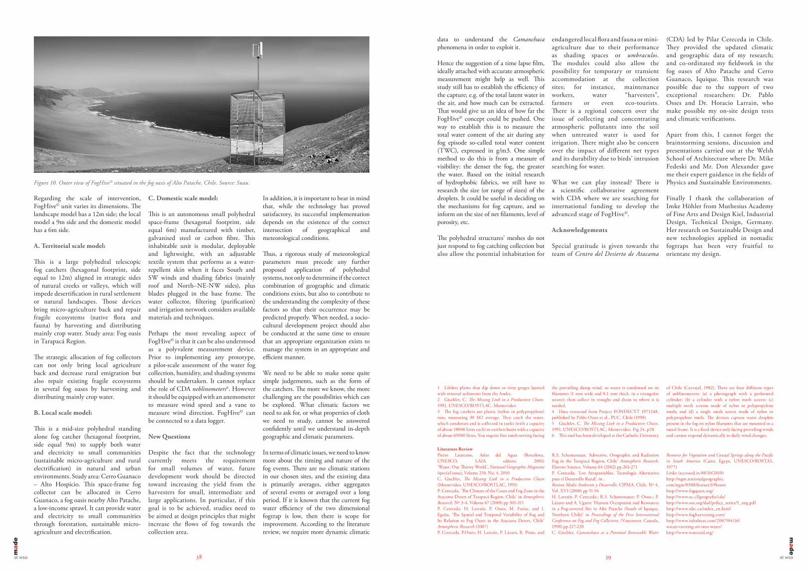
Figure 10. Outer view of FogHive© situated in the fog oasis of Alto Patache, Chile. Source: Suau.
endangered local flora and fauna or mini-agriculture due to their performance as shading spaces or umbraculos. The modules could also allow the possibility for temporary or transient accommodation at the collection sites; for instance, maintenance workers, water “harvesters”, farmers or even eco-tourists. There is a regional concern over the issue of collecting and concentrating atmospheric pollutants into the soil when untreated water is used for irrigation. There might also be concern over the impact of different net types and its durability due to birds’ intrusion searching for water.
What we can play instead? There is a scientific collaborative agreement with CDA where we are searching for international funding to develop the advanced stage of FogHive©.
Acknowledgements
Special gratitude is given towards the team of Centro del Desierto de Atacama
(CDA) led by Pilar Cereceda in Chile. They provided the updated climatic and geographic data of my research; and co-ordinated my fieldwork in the fog oases of Alto Patache and Cerro Guanaco, Iquique. This research was possible due to the support of two exceptional researchers: Dr. Pablo Osses and Dr. Horacio Larrain, who make possible my on-site design tests and climatic verifications.
Apart from this, I cannot forget the brainstorming sessions, discussion and presentations carried out at the Welsh School of Architecture where Dr. Mike Fedeski and Mr. Don Alexander gave me their expert guidance in the fields of Physics and Sustainable Environments.
Finally I thank the collaboration of Imke Höhler from Muthesius Academy of Fine Arts and Design Kiel, Industrial Design, Technical Design, Germany. Her research on Sustainable Design and new technologies applied in nomadic fogtraps has been very fruitful to orientate my design.
1 Lifeless plains that dip down to river gorges layered with mineral sediments from the Andes.2 Gischler, C. The Missing Link in a Production Chain. 1991, UNESCO/ROSTLAC, Montevideo3 The fog catchers are plastic (nylon or polypropylene) nets, measuring 30 M2 average. They catch the water, which condenses and is collected in tanks (with a capacity of about 18000 litres each) or earthen basin with a capacity of about 65000 litres. You require fine mesh netting facing
the prevailing damp wind, so water is condensed on its filaments (1 mm wide and 0.1 mm thick, in a triangular weave); then collect in troughs and drain to where it is needed.4 Data extracted from Project FONDECYT 1971248, published by Pablo Osses et al., PUC, Chile (1998)5 Gischler, C. The Missing Link in a Production Chain. 1991, UNESCO/ROSTLAC, Montevideo. Fig 24, p286 This tool has been developed at the Catholic University
of Chile (Carvajal, 1982). There are four different types of neblinometers: (a) a pluviograph with a perforated cylinder; (b) a cylinder with a nylon mesh screen; (c) multiple mesh screens made of nylon or polypropylene mesh; and (d) a single mesh screen made of nylon or polypropylene mesh. The devices capture water droplets present in the fog on nylon filaments that are mounted in a metal frame. It is a fixed device only facing prevailing winds and cannot respond dynamically to daily wind changes.
Literature ReviewPietro Laureano, Atlas del Agua (Barcelona, UNESCO, LAIA editors: 2001) ‘Water: Our Thirsty World’, National Geographic Magazine (special issue), Volume 210, No. 4, 2010C. Gischler, The Missing Link in a Production Chain (Montevideo, UNESCO/ROSTLAC, 1991)P. Cereceda, ‘The Climate of the Coast and Fog Zone in the Atacama Desert of Tarapacá Region, Chile’ in Atmospheric Research, Nº 3-4, Volume 67 (2008) pp 301-311P. Cereceda, H. Larraín, P. Osses, M. Farías, and I. Egaña, ‘The Spatial and Temporal Variability of Fog and Its Relation to Fog Oases in the Atacama Desert, Chile’ Atmospheric Research (2007)P. Cereceda, P.Osses, H. Larraín, P. Lázaro, R. Pinto, and
R.S. Schemenauer, ‘Advective, Orographic and Radiation Fog in the Tarapacá Region, Chile’ Atmospheric Research, Elsevier Science, Volume 64 (2002) pp 261-271P. Cereceda, ‘Los Atrapanieblas, Tecnología Alternativa para el Desarrollo Rural’, in .Revista Medio Ambiente y Desarrollo, CIPMA, Chile. Nº 4, Vol. XVI (2000) pp 51-56H. Larraín; P. Cereceda.; R.S. Schemenauer; P. Osses.; P. Lázaro and A. Ugarte ‘Human Occupation and Resources in a Fog-covered Site in Alto Patache (South of Iquique, Northern Chile)’ in Proceedings of the First International Conference on Fog and Fog Collection, (Vancouver, Canada, 1998) pp 217-220C. Gischler, Camanchaca as a Potential Renewable Water
Resource for Vegetation and Coastal Springs along the Pacific in South America (Cairo, Egypt, UNESCO/ROSTAS, 1977)Links (accessed in 08/10/2010)http://ngm.nationalgeographic.com/ngm/0308/feature3/#know http://www.fogquest.org/ http://www.uc.cl/geografia/cda/ http://www.oas.org/dsd/policy_series/5_eng.pdf http://www.idrc.ca/index_en.html http://www.fogharvesting.com/ http://www.inhabitat.com/2007/04/16/watair-turning-air-into-water/ http://www.wateraid.org/